Design Guidelines. Gardnerville Plan for Prosperity
|
|
|
- Alice Horn
- 6 years ago
- Views:
Transcription


1 Design Guidelines Gardnerville Plan for Prosperity June 2006
2
3 Contents SECTION ONE: Introduction 1.1 Purpose 1.2 Relationship to other Policies and Documents 1. Organization of the Design Guidelines 1.4 Using the Guidelines 1.5 Understanding Context and Defining Features 1.6 Submittal Requirements SECTION TWO: Overall Design Guidelines 2.1 Site Planning Guidelines 2.2 Architectural Guidelines 2. Signage Guidelines SECTION THREE: Character District Guidelines.1 Old Town.2 S Curve. Millerville.4 Commercial Quad.5 South-Central.6 South Entry


4 then 1940 now 1970 then 2002 Gardnerville s History The Town of Gardnerville was founded in 1879 by Lawrence Gilman of Genoa when he moved the Kent House from the Genoa area to a 7-acre tract of land on the East Fork of the Carson River. Gilman had purchased the land from a homesteader, John M. Gardner, in whose honor he named the new town. In its new location, the Kent House was renamed the Gardnerville Hotel. The hotel is no longer standing, but its site was just west of the present J & T Bar, near the intersection of Eddy and Main Streets (US Highway 95). Gilman added a blacksmith shop and a saloon to his hotel to ensure his town s utility and popularity with the ranchers. As the town prospered, a number of hotels, shops, and saloons sprang up. By 1899, Main Street was lined with two livery stables, a woodworking shop, a boarding house, a tin shop, three general merchandising stores, a hall, four saloons, one meat market, one furniture store, a drug and confectionary store, and two hotels. The Valhalla Society-a Danish organization whose purpose was to disseminate information to immigrantswas formed in 1885, making Gardnerville an important social center in the valley as well as a commercial center. Because of its location, Gardnerville came to serve as feed stop for the 24-horse freight teams passing between Carson City and Bodie. (Dangberg, Grace. Carson Valley: Historic Sketches of Nevada s First Settlement. Carson Valley Historical Society. Carson Valley, Nevada, 1972.) now then now


5 Introduction Gardnerville is located in one of the most quickly urbanizing counties in the West. The Town realizes it has the responsibility to plan and develop commercial and mixed-use districts to support higher standards for investment. The community s expectations for more livable neighborhoods have motivated the Town s leadership to press forward with design policies to be included in the Douglas County Master Plan and design guidelines. These guidelines, and the community discussion that guided their preparation, demonstrate this commitment. Above: New investment should contribute to the preservation, enhancement, and creation of livable mixed-use neighborhoods. 1.1 Purpose of Guidelines The Gardnerville Town Board views the quality of the built and natural environment as an important priority. Participants in the Plan for Prosperity process stressed raising expectations for reinvesting along US 95. In newly developed areas, the pattern of development is replicating many of the same undesirable patterns and design issues found in the aging auto-oriented commercial districts. These guidelines, and the associated design review process, are intended to support the Town s efforts to improve community design and encourage reinvestment. The Guidelines communicate the community s qualitative expectations for new commercial and mixed-use development. The Guidelines are a tool used by project sponsors, Town Board, County staff, the County Planning Commission and Board of Commissioners to support policies in the County Master Plan. The document provides: Gardnerville Plan for Prosperity In 2005, the Town of Gardnerville prepared the Plan for Prosperity. The Plan included land use, circulation and community design policies and a supporting action plan for vacant and underutilized land along US 95. The Plan provides additional flexibilpage 1 A general description of expectations for investment in Gardnerville s Mixed-use Overlay areas; Design criteria for site planning; Architectural design guidelines; Signage design guidelines; and The submittal requirements that support design review process. 1.2 Relationship to other Plans and Policies The Guidelines are part of the Town s and County s planning and development review system that includes the policies in the Douglas County Master Plan; policies and strategies found in the Gardnerville Plan for Prosperity; and standards in the County s development code.
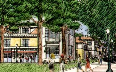
 Sketch of the corner of Gilman")
 Sketch of South")

6 Gardnerville Plan for Prosperity Design Guidelines 1 Above and Right: (1) Sketch of the corner of Gilman and Heritage Park (2) Sketch of commercial service frontage at Stodick Parkway 2 () Sketch of South Valley Plaza a mixed-use neighborhood with commercial frontage and plaza that serves as Gardnerville s southern entry page 2


7 Introduction The Gardnerville Plan for Prosperity makes recommendations for existing non-residential areas along US 95. The Plan provides added detail for three important opportunity sites Old Town, Stodick Parkway/US 95, and the South Gateway. 1 2 KEY 1. Old Town 2. Stodick Parkway/US 95. South Gateway page

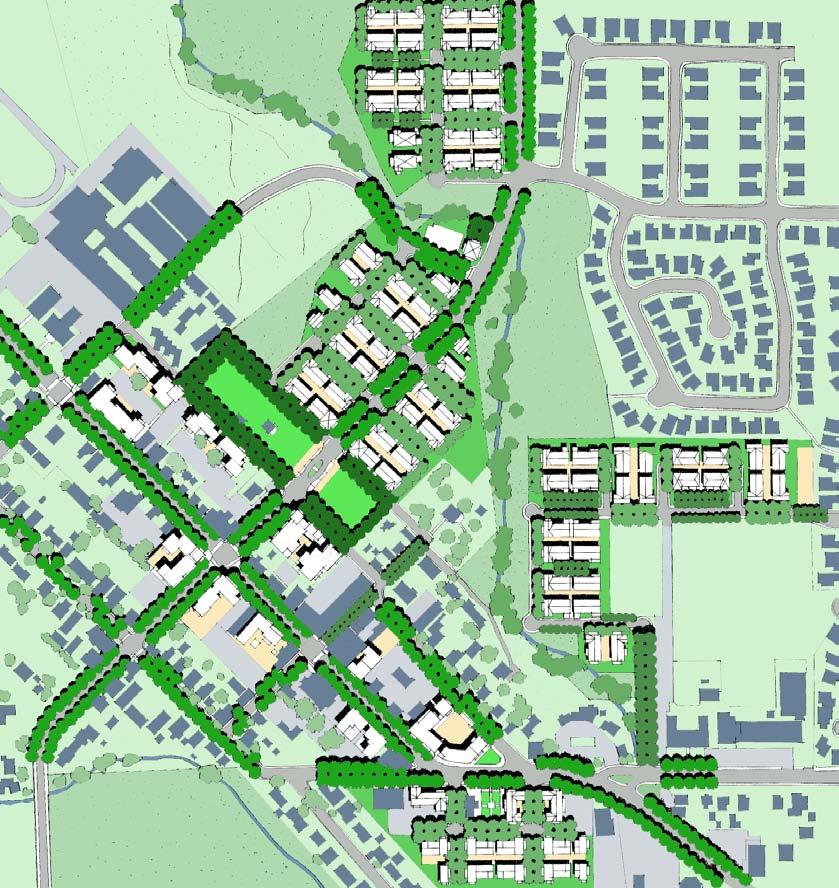
8 Gardnerville Plan for Prosperity Design Guidelines ity for property owners and investors to mix residential and commercial uses. These policies are expressed in a Mixed-use Overlay where new standards are intended to be more flexible and the Guidelines communicate the expected quality for new investment. The goals and policies were integrated into the County Master Plan 10-year update. Gardnerville Mixed-use Overlay The Guidelines convey qualitative criteria for new development in the Gardnerville s Mixed-use Overlay. The Mixed-use Overlay is an area identified in the Plan for Prosperity where mixing of residential and commercial uses are encouraged. In this area connections and interface with adjacent residential neighborhoods is critically important meeting then Town s objectives for building a community that is walkable. The Mixeduse Overlay policy is identified in the County s Master Plan. County Master Plan The Douglas County Master Plan is the blueprint for future public and private investment. It contains urban planning policies for Minden- Gardnerville that establishes regulatory and implementation criteria for the Towns. The Minden-Gardnerville section of the Master Plan has been updated to reflect policies identified in Minden s and Gardnerville s local visioning and strategic planning efforts. County Development Standards and Guidelines The County s development standards provide the quantitative criteria for projects. These include allowable uses, height and setback requirements, parking standards and other measurable criteria. The standards are to be updated to reflect new Master Plan polices and emphasis on pedestrian-friendly development. Gardnerville Mixed- Use Overlay Design Guidelines supercede Douglas County design guidelines. 1. Organization of the Guidelines The Design Guidelines are organized into three sections. Section One Organization The first section is the Introduction. It contains a summary of the Guideline s purpose and process, how they are organized, how to use them, how to look at context, and submittal requirements. The section includes overall guidelines for site planning, architecture and signage. The third section provides guidelines that pertain to sub-areas with their own unique character. Section Two Organization The second section includes principles, design goals and guidelines. The principles are the most important. Every project should be able to demonstrate that they meet these. The design goals are also important, but may not apply to every project. The guidelines provide greater detail and apply to specific issues and types of projects based on their scope and context. Not all guidelines necessarily apply to each project. Section Three Organization The third section provides primary principles for six character areas or sub-areas in the Mixed-use Overlay. These principles come from the Gardnerville Plan for Prosperity Design Policies. Supporting these is a list of important urban design concepts and guidelines that reflect the planning objectives identified by the Town for each character area. 1.4 Using the Guidelines Below and Right: This overhead view of Old Town shows new development around Heritage Park (1), redevelopment of the S' Curve (2), and infill development along Main Street (). The concept locates parking in the interior of blocks and places commercial storefronts along streets. Residential development happens above or behind commercial storefronts. Gilman 1 2 Main Street page 4

9 Introduction 1 The Design Guidelines define Gardnerville s and Douglas County s expectations for site planning, architectural design and signage. They do not add steps to the development review process but increase the amount of discussion about HOW projects address the design policies in the County Master Plan. The Guidelines are a tool for project sponsors, the Town and County that frames the design discussion. Who Reviews the Design of Projects? The Town Board currently reviews projects in Gardnerville. The Board makes a recommendation to the County Planning Commission and County Commission. The County is required to implement the Master Plan design policies, which are the basis for the Guidelines. Project sponsors can take advantage of the more flexible development standards in the Mixed-use Overlay by demonstrating to the Town how they have applied the Guidelines to their projects. Do the Guidelines Apply to Your Project? If your project falls within the Mixeduse Overlay, then they apply except if the project is exempt from development review. Exempt projects include interior renovations, singlefamily homes not requiring subdivision, and minor renovations. What Sections Apply? The Guidelines includes Overall Guidelines (Section One) and Character District Guidelines (Section Two). Overall Guidelines apply to every project in the Mixeduse Overlay. The Character District Guidelines provide criteria for different neighborhoods in the Mixed-use Overlay. For example, if your project is located in Old Town, you would use sections 2.1 (overall site planning guidelines), 2.2 (overall architectural design guidelines), 2. (overall signage guidelines) and.1 (guidelines for Old Town). 1.5 Focus on Fitting Projects into Their Context The Town expects each project to contribute to implementing circulation, architectural and signage objectives for the site and surrounding area. Each project should be planned and designed to fit existing and anticipated investment with a particular focus on the pedestrian experience. Project sponsors need to consider the following questions. Site connections: How can driveway and sidewalks design increase the connectivity and accessibility between the commercial and residential portions of the project and the district? Building alignments and orientation: How can building alignments, orientation and transparency contribute to pedestrian connections? What are friendly building and landscape setbacks along public streets? How are building storefronts, residential yards and entries oriented? Streetscape and landscape design: What type trees exist along public streets? Is there a landscape plan for the neighborhood or district? How can the landscape plan help to knit the project together and link it to the surrounding community? Roadway and parking lot design: How can parking lots and driveways be designed to increase pedestrian comfort, safety and connectivity? How can trees be used to reduce heat generated by parking lots? Architectural context: What are the page 5


10 Gardnerville Plan for Prosperity Design Guidelines strongest architectural features in the adjacent neighborhoods and buildings and how can the project complement them? Signage design: How can an overall signage concept contribute to the graphic identity of the project and the area? 1.6 Submittal Requirements The development review process already requires basic project information. The Guidelines require additional information about the development site context. The Town s design and development review submittal requirements require the following exhibits: Context Analysis for Design Review Board with photos showing site and adjacent structures Map including adjacent neighborhoods, site features (existing buildings, trees, creeks, views, slopes, etc) and adjacent structures One page written description of how the project has responded to its current and future context Development Program Summary Site plan, size and dimensions Existing and proposed square feet and unit count Existing and proposed parking Multifamily private and any common usable open areas Subdivision Design Information (Subdivision only) Subdivision lot layout Grading plan/contours and site sections Any proposed improvements such as landscaping or fences/walls Design Information Typical building elevations Typical floor plans and roof plans Site cross sections Site landscape plan Fence/wall details Color and material board Typical street sections Sketches of public elements (as requested by the Town) The Design Guidelines are part of the Gardnerville Plan for Prosperity. They were developed through a community process. Above Top: Planning Opportunities and Options Workshop, April 6, 2005 Above Bottom: Preliminary Concepts, May 25, 2005 Left: Preliminary Framework Plan Review, October 20, 2005 page 6
SECTION TWO: Urban Design Concepts
 SECTION TWO: Urban Design Concepts The Gardnerville Plan for Prosperity shapes economic opportunities presented by regional growth. The Urban Design Concepts provide policies and concepts for land use,
Status Update (2006 vs. Now) Citizen s Advisory Committee February Plan for Prosperity
 Citizen s Advisory Committee February Plan for Prosperity") Status Update (2006 vs. Now) Citizen s Advisory Committee February 2018 Plan for Prosperity 2000 2017 2000 2017 Gardnerville Population 6,000 5,760 5746 5,500 5,000 5,067 5,550 5,165 5,394 5,412 5,250
Status Update (2006 vs. Now) Citizen s Advisory Committee February 2018 Plan for Prosperity 2000 2017 2000 2017 Gardnerville Population 6,000 5,760 5746 5,500 5,000 5,067 5,550 5,165 5,394 5,412 5,250
SECTION TWO: Overall Design Guidelines
 SECTION TWO: Overall Design Guidelines This section provides overall design principles and guidelines for the Gardnerville Mixed-use Overlay. They provide criteria for mixed-use places consisting of residential,
PROSPERITY. A Strategic Framework Plan for Investing in Minden s Future. January 2003
 MINDEN PLAN PROSPERITY FOR A Strategic Framework Plan for Investing in Minden s Future January 2003 prepared by: Minden Plan for Prosperity Citizens Advisory Committee with assistance by: RACESTUDIO and
Corridors. Re-vitalize our Corridors and Gateways
 Corridors Re-vitalize our Corridors and Gateways Artist s rendering from the 287 Strategic Plan, 2015 Corridors are the major throughways of Loveland but they also provide important commercial, community
4.1.3 LAND USE CATEGORIES
 4.1.3 LAND USE CATEGORIES a. City Center District The City Center District incorporates the existing character and mix of uses in downtown Belmont to encourage redevelopment and new development in keeping
INSTITUTIONAL USE DESIGN COMPATIBILITY TECHNIQUES
 INSTITUTIONAL USE DESIGN COMPATIBILITY TECHNIQUES INTRODUCTION Community institutions are an important part of the character and vitality of neighborhoods in Forsyth County. Institutional uses include
Hockessin Community Redevelopment Plan
 Hockessin Community Redevelopment Plan 3.1 Introduction The Community Redevelopment Plan for the Village of Hockessin is the result of the people s vision for a distinct village center that serves as the
Lower Merion Commercial Districts Issues and Characteristics Handbook November 2013
 Lower Merion Commercial Districts Issues and Characteristics Handbook November 2013 DRAFT TOWNSHIP-WIDE VISION: To maintain and enhance commercial areas to complement the surrounding high-quality residential
NEC of Central Avenue and Indian School Road
 NEC of Central Avenue and Indian School Road For this location, there are two applicable plans that provide guidance on development. The two plans include the Indian School Specific Plan (1991) and the
NEIGHBORHOOD DESIGN ELEMENT
 NEIGHBORHOOD DESIGN ELEMENT INTRODUCTION The following recommendations constitute an urban design oriented "neighborhood analysis" of Plantation. It is an optional Comprehensive Plan Element. The five
A BLUEPRINT FOR BROCKTON A CITY-WIDE COMPREHENSIVE PLAN
 A BLUEPRINT FOR BROCKTON A CITY-WIDE COMPREHENSIVE PLAN Public Meeting October 2016 1 Plan Summary and Discussion Public Meeting May 4 2017 City of Brockton Bill Carpenter, Mayor Department of Planning
Mark-up of the effect of the proposed Bronte Village Growth Area OPA No.18 on the text of section 24, Bronte Village, of the Livable Oakville Plan
 Mark-up of the effect of the proposed Bronte Village Growth Area OPA No.18 on the text of section 24, Bronte Village, of the Livable Oakville Plan Notes: This document is provided for information purposes
WELCOME and introduction
 1 WELCOME and introduction Mobility Hub Locations within Burlington STUDY OVERVIEW STUDY OBJECTIVES The City of Burlington is developing four Area Specific Plans, one for each of Burlington s Mobility
124 Subarea Visions. Vision Plan. A. Nelessen Associates, INC I Visioning I Planning I Urban Design
 Subareas 124 Subarea Visions The next seven sections describe specific recommendations tailored to each subarea. Each subarea is discussed separately except for certain aspects of 95th Street and Antioch
URBAN DESIGN BRIEF 181 Burloak Drive, Oakville
 URBAN DESIGN BRIEF 181 Burloak Drive, Oakville February 2017 Our File: 1730B 230-7050 WESTON ROAD / WOODBRIDGE / ONTARIO / L4L 8G7 / T: 905 761 5588/ F: 905 761 5589/WWW.MHBCPLAN.COM TABLE OF CONTENTS
Table of Contents. Elm Avenue Improvement Plan City of Waco, Texas. Introduction 1. Existing Context 1 Figure 1 2.
 Table of Contents Introduction 1 Existing Context 1 Figure 1 2 Plan Guidelines 3 Future Urban Form 4 The West-End 4 Main Street 6 The East-End 7 Figure 2 9 Public Improvement Recommendations 7 General
CHAPTER 12 IMPLEMENTATION
 CHAPTER 12 IMPLEMENTATION The 2010 Town of Denton Comprehensive Plan is intended to capture a vision of the future of Denton. As such, it provides a basis for a wide variety of public and private actions
PUBLIC RIGHT-OF-WAY IN THIS CHAPTER PUBLIC REALM
 PUBLIC RIGHT-OF-WAY This section provides design guidelines for improvements in the public right-of-way. The public right-of-way refers to streets, sidewalks, non-vehicular thoroughfares, parks and greenways
Future Five. Design/ Development Guidelines. January 2008 Amended June 08 per City Council motion
 Future Five Design/ Development Guidelines January 2008 Amended June 08 per City Council motion 5-Points Design Guidelines Table of Contents I. Introduction 3 II. Area boundaries 4 III. Review Process
City of Farmington. Downtown Plan. Amendment to the 1998 Master Plan Adopted October 11, 2004
 City of Farmington Amendment to the 1998 Master Plan Adopted October 11, 2004 Introduction Planning Background 1 Scope and Components of the Plan Amendment 2 Concept Introduction 3 Plan Concepts 3 Conceptual
Small Area Plan. South Gateway
 Small Area Plan Adopted May 12, 2008 South Gateway Purpose. The South Gateway Small Area Plan defines the City s expectations for the future of the southern entrance to the City at Interstate 85 and Highway
PINE CURVE REZONING. BACKGROUND Purchased as two parcels in 2001 and 2002
 BACKGROUND Purchased as two parcels in 2001 and 2002 WHAT THE PROJECT IS AND IS NOT A Rezoning establishes the land use standards for Annexed and Zoned Greater Downtown District Historic Center September
DRAFT Northeast Quadrant of Kipling Avenue and Highway 7 DRAFT AUGUST 29, Goals Land Use. The goals of this Plan are to:
 AUGUST 29, 2017 12.15 Northeast Quadrant of Kipling Avenue and Highway 7 12.15.1 Goals 12.15.2 Land Use The goals of this Plan are to: 12.15.2.1 General Provisions: a) Ensure the development of a compact
About Momentum Midland
 About Momentum Midland Achieving a community s full potential in terms of economic development and quality of life is critically important to its long term sustainability. Core to achieving this is a vibrant
QUEEN-RIVER SECONDARY PLAN
 34 QUEEN-RIVER SECONDARY PLAN 34. QUEEN RIVER SECONDARY PLAN 1. INTRODUCTION The Queen-River area is approximately 6.4 hectares and is located at the eastern edge of the Downtown as shown on Map 34-1.
CITY OF CHARLOTTESVILLE, VIRGINIA CITY COUNCIL AGENDA
 CITY OF CHARLOTTESVILLE, VIRGINIA CITY COUNCIL AGENDA Agenda Date: December 16, 2013 Action Required: Adoption of Resolution Presenter: Staff Contacts: Title: James E. Tolbert, AICP, Director of NDS James
Pedestrian and Bike Bridge LOGO
 6.2.2 Pedestrian and Bike Bridge The proposed pedestrian and bike crossing re-envisions the existing bridge at Pismo Creek on Cypress Street. The bridge is currently underutilized by vehicular through
FLORIN ROAD CORRIDOR Site Plan and Design Review Guidelines Checklist
 FLORIN ROAD CORRIDOR Site Plan and Design Review Guidelines Checklist Applicant s Name: Project Address: Phone: Email: Applicant shall fill out the design guidelines checklist for all guidelines applicable
expectations for new development W A T E R F R O N T D R I V E
 expectations for new development W A T E R F R O N T D R I V E 1 April 2004 W A T E R F R O N T D R I V E expectations for new development Introduction and Intent This statement of expectations for development
URBAN DESIGN BRIEF. 2136&2148 Trafalgar Road. Town of Oakville
 URBAN DESIGN BRIEF 2136&2148 Trafalgar Road Town of Oakville Prepared By: METROPOLITAN CONSULTING INC For 2500674 Ontario Inc November 2016 TABLE OF CONTENTS Page No. 1.0 Introduction/Description of Subject
TUSTIN RED HILL DEVELOPMENT TUSTIN CITY COUNCIL WORKSHOP
 TUSTIN RED HILL DEVELOPMENT TUSTIN CITY COUNCIL WORKSHOP 7-6-15 CONTEXT MAP PREVIOUS CHURCH AND ADJACENT RETAIL SITE EXISTING RETAIL CENTER SITE CONDITIONS PREVIOUS SITE CONDITIONS PREVIOUSLY APPROVED
A Context-Based Design Code for Pedestrian & Transit-Oriented Development RAIL~VOLUTION NOVEMBER 2006
 A Context-Based Design Code for Pedestrian & Transit-Oriented Development RAIL~VOLUTION NOVEMBER 2006 Palo Alto Zoning Ordinance Update. Project Overview City of Palo Alto Palo Alto Zoning Ordinance Update.
NORTHGATE AREA. Design Guidelines. Effective, final draft: 2 may 02. City of Seattle Department of Design, Construction & Land Use
 NORTHGATE AREA neighborhood urban village Design Guidelines Effective, final draft: 2 may 02 City of Seattle Department of Design, Construction & Land Use Design Review: Northgate Area Neighborhood Design
Gold Line Bus Rapid Transit Transit Oriented Development (BRTOD) Helmo Station Area Plan
 Helmo Station Area Plan") Appendix F Gold Line Bus Rapid Transit Transit Oriented Development (BRTOD) Helmo Station Area Plan Introduction and Purpose of the Plan The Gold Line Bus Rapid Transit facility is an eleven-mile dedicated
Appendix F Gold Line Bus Rapid Transit Transit Oriented Development (BRTOD) Helmo Station Area Plan Introduction and Purpose of the Plan The Gold Line Bus Rapid Transit facility is an eleven-mile dedicated
ARTICLE 6: Special and Planned Development Districts
 ARTICLE 6: Special and Planned Development Districts 6-10 Traditional Neighborhood Development (TND) District 6-10.10 Purpose and Intent The Traditional Neighborhood Development (TND) District provides
Town Center (part of the Comprehensive Plan)
") Town Center (part of the Comprehensive Plan) Mercer Island Town Center Looking North (2014) In 1994, a year-long process culminated in a set of design guidelines and code requirements for the Town Center
Town Center (part of the Comprehensive Plan) Mercer Island Town Center Looking North (2014) In 1994, a year-long process culminated in a set of design guidelines and code requirements for the Town Center
URBAN DESIGN BRIEF REPORT
 URBAN DESIGN BRIEF REPORT PREPARED FOR 2568401 ONTARIO INC NEW GASBAR, CONVENIENCE STORE & CARWASH DEVELOPMENT @ 1509 FANSHAWE PARK ROAD WEST LONDON, ONTARIO GAMA ENGINEERING INC. PROJECT NUMBER 1669 PREPARED
Urban Design Manual PLANNING AROUND RAPID TRANSIT STATIONS (PARTS) Introduction. Station Study Areas
 Introduction. Station Study Areas") 111111 PLANNING AROUND RAPID TRANSIT STATIONS (PARTS) Introduction The ION rapid transit system will link Waterloo, Kitchener and Cambridge through a central transit corridor (CTC). There are a number
111111 PLANNING AROUND RAPID TRANSIT STATIONS (PARTS) Introduction The ION rapid transit system will link Waterloo, Kitchener and Cambridge through a central transit corridor (CTC). There are a number
Clairtrell Area Context Plan
 Clairtrell Area Context Plan March 2005 Urban Development Services City Planning Contents 1. Introduction... 4 2. Development Structure... 6 2.1 Streets... 7 2.1.1 Sheppard Avenue and Bayview Avenue...
Urban Design Brief. 875 Wellington Road. Proposed One-Storey Fast Food Restaurant and Two-Storey Restaurant. Wellington Harlech Centre Inc.
 Urban Design Brief 875 Wellington Road Proposed One-Storey Fast Food Restaurant and Two-Storey Restaurant Wellington Harlech Centre Inc. Prepared By: (519) 433-7587 info@yorkdev.ca May 3 rd 2013 1 Table
EXHIBIT A. Tax Increment Reinvestment Zone No. 1 (Town Center) First Amended Project Plan 1
 First Amended Project Plan 1") EXHIBIT A Tax Increment Reinvestment Zone No. 1 (Town Center) First Amended Project Plan 1 1 As amended by Resolution No. 2008-02-001(TR1R) of the Tax Increment Reinvestment Zone No.1, and approved to
EXHIBIT A Tax Increment Reinvestment Zone No. 1 (Town Center) First Amended Project Plan 1 1 As amended by Resolution No. 2008-02-001(TR1R) of the Tax Increment Reinvestment Zone No.1, and approved to
Draft Plan Recommendations
 Draft Plan Recommendations Sponsored by Henry County and the Atlanta Regional Commission T S W TEAM Tunnell-Spangler-Walsh & Associates URS Corporation Marketek Study Area 1,300 acres Includes parts of
Policies and Code Intent Sections Related to Town Center
 Policies and Code Intent Sections Related to Town Center The Town Center Vision is scattered throughout the Comprehensive Plan, development code and the 1994 Town Center Plan. What follows are sections
URBAN DESIGN BRIEF URBAN DESIGN BRIEF 721 FRANKLIN BLVD, CAMBRIDGE August 2018
 URBAN DESIGN BRIEF URBAN DESIGN BRIEF 721 FRANKLIN BLVD, CAMBRIDGE August 2018 DESIGN BRIEF CONTENTS PART A 1.0 INTRODUCTION 2.0 DESCRIPTION & ANALYSIS OF SITE CONTEXT 3.0 DESIGN CONSTRAINTS AND OPPORTUNITIES
A. Background Summary of Existing Challenges and Potential Possibilities. 1. Summary of Existing Assets and Potential Opportunities
 A. Background 1 A Main Street Master Plan Study was performed and completed in October of 2007. The study was initiated to review current land uses and development patterns along Main Street, from Parrish
Planning Districts INTRODUCTION
 INTRODUCTION To facilitate detailed examination of development prospects for all areas of the community, Delano has been divided into 14 planning districts. The location of these planning districts is
Derry Green Corporate Business Park
 Town of Milton Derry Green Corporate Business Park Urban Design Guidelines BMI/Pace - June 2010 Draft 3 Prepared by: Brook McIlroy Planning + Urban Design / Pace Architects Suite 300-51 Camden Street Toronto,
Community Design Plan
 Gardena General Plan 2006 Authority While the is not a required element of a General Plan, it is included because improving the community appearance and image is paramount to the overall quality of life
September 30, 2014 Ms. Lorraine Weiss Department of Community Development City of San Mateo 330 West 20th Avenue San Mateo, CA
 ARCHITECTURE PLANNING URBAN DESIGN September 30, 2014 Ms. Lorraine Weiss Department of Community Development City of San Mateo 330 West 20th Avenue San Mateo, CA 94403-1388 RE: Station Park Green Dear
CHAPTER 3 VISION, GOALS, & PLANNING PRINCIPLES. City of Greensburg Comprehensive Plan. Introduction. Vision Statement. Growth Management Goals.
 CHAPTER 3 VISION, GOALS, & PLANNING PRINCIPLES Introduction The Greensburg Comprehensive Plan is intended as a working community document. A combination of long and short-term goals, this document is intended
Cobb County Design Guidelines Mableton Parkway & Veterans Memorial Highway Community Design Workshop January 12, 2017
 Community Design Workshop January 12, 2017 Agenda Opening Remarks / Introductions Scope of Work Existing Conditions Key Issues / Opportunities VPS Summary Draft Vision & Goal Statement Implementation Concepts
Blueprint Denver A BLUEPRINT FOR AN INCLUSIVE CITY. Executive Summary
 Blueprint Denver A BLUEPRINT FOR AN INCLUSIVE CITY Executive Summary PUBLIC REVIEW DRAFT 2 1/7/2019 DENVERIGHT BLUEPRINTDENVER Blueprint Denver: A Blueprint for an Inclusive City An Equitable City Planning
PLANNING COMMISSION. Agenda Item # 6.
 PLANNING COMMISSION Agenda Item # 6. LAND DEVELOPMENT CODE AMENDMENT Planning Commission: October 5, 2016 Case: LDC-6-1016 Staff Contact: Eryn K. Moller; eryn.moller@wilmingtonnc.gov 910-341-4695 Staff
Asbury Chapel Subdivision Sketch Plan
 Asbury Chapel Subdivision Sketch Plan PART 1: PROJECT SUMMARY Applicant: NVR Inc. Project Size: +/- 76.13 acres Parcel Numbers: 02101112,02116101,02116112, 02116113 Current Zoning: Transitional Residential
GUIDING PRINCIPLES IN THIS CHAPTER
 GUIDING PRINCIPLES The guiding principles and design concepts in this chapter work together with the Chapel Hill 2020 Comprehensive Plan to support new public places that can be enjoyed by all while also
DENVER DESIGN DISTRICT GDP
 DENVER DESIGN DISTRICT GDP Urban Design Standards and Guidelines November 17, 2008 Amended February 3, 2016 City and County of Denver CF Property Management, Inc. C/O Denver Design District - Starboard
SH 199 Corridor Master Plan. Community Meeting No. 2 May 31, 2017
 Community Meeting No. 2 May 31, 2017 Transportation Projects On or Near SH 199 SH 199 from 0.3 miles south of FM 1886 to south end of Lake Worth bridge Construct freeway mainlanes and frontage roads 10-Year
REVIEW AND EVALUATION OF REGIONAL LAND USE
 REVIEW AND EVALUATION OF REGIONAL LAND USE AND TRANSPORTATION SCENARIOS #220831 Environmental Justice Task Force October 7, 2014 VISION 2050 Process Development of Guiding Vision for Land Use and Transportation
Design Guidelines Strategy
 DRAFT Design Guidelines Strategy FARRAGUT ARCHITECTURAL DESIGN GUIDELINES PROJECT Design Guidelines Strategy July 28, 2014 The Town of Farragut is drafting a comprehensive set of architectural design guidelines
Hopkins. Development Guidelines May Overview. Sponsored by: Blake Road Corridor Collaborative City of Hopkins
 Hopkins Blake Road LRT Station Area Development Guidelines May 2015 Sponsored by: Blake Road Corridor Collaborative City of Hopkins Overview Hopkins is a dynamic community of over 17,000 residents located
Danvers High Street I-1 District Study
 Danvers High Street I-1 District Study Presentation of Final Recommendations Planning Board Presentation June 26 th, 2018 1 Introductions Metropolitan Area Planning Council Sam Cleaves AICP, Principal
Strategic Growth Area #1 Northampton Boulevard Corridor Area
 Strategic Growth Area #1 Northampton Boulevard Corridor Area Description Strategic Growth Area #1 has established itself as a major employment center in Southside Hampton Roads. Opportunities exist to
Downtown North Las Vegas Demonstration Site Project. Project Update
 Downtown North Las Vegas Demonstration Site Project Project Update 7.16.14 Presentation Overview Project Purpose and Process Planning Context Opportunities and Barriers Summary Community Input Preliminary
Appendix A COMMUNITY IMPROVEMENT PLAN DESIGN GUIDELINES
 Appendix A COMMUNITY IMPROVEMENT PLAN DESIGN GUIDELINES INTRODUCTION The continuous and desirable improvement of Arnprior requires a clear understanding of what is envisioned for the Town. These Design
Town of Oakville Streetscape Strategy
 Town of Oakville Streetscape Strategy Endorsed by PDC on February 10, 2014 (PD-011-14) Town of Oakville Streetscape Strategy [endorsed by PDC February 10, 2014] 0 Town of Oakville Streetscape Strategy
Planning Commission Staff Report June 5, 2008
 Owner/Applicant Taylor Village Sacramento Investments Partners, LP c/o Kim Whitney 1792 Tribute Road #270 Sacramento, CA 95815 Staff Recommendation Planning Commission Staff Report Project: File: Request:
THE 355/270 CORRIDOR:
 THE 355/270 CORRIDOR: Strategic Ideas for Sustaining a Livable Work Place Project Summary ACCESS LIFE DESIGN HEALTH WORK Montgomery County Planning Department The Maryland-National Capital Park and Planning
SECTION ONE: INTRODUCTION. introduction
 introduction 1 INTRODUCTION Since it was first established in 1843 as a trading post for the Hudson s Bay Company, Victoria has evolved into a Provincial capital city that is recognized across Canada and
Status Report: MD 355 Project
 Status Report: MD 355 Project OCTOBER 2006 M-NCPPC MONTGOMERY COUNTY PLANNING DEPARTMENT Summary of Community Comments, and break to the Results of the MD 355 Participation Session Brookside Gardens -
Implementation Guide Comprehensive Plan City of Allen
 Implementation Guide 2030 Comprehensive Plan City of Allen DRAFT 2015 Implementation Guide Allen 2030 Comprehensive Plan INTRODUCTION The Comprehensive Plan serves as a guide for the growth and development
Long Branch Neighbourhood Character Guidelines Final Report
 STAFF REPORT ACTION REQUIRED Long Branch Neighbourhood Character Guidelines Final Report Date: October 26, 2017 To: From: Wards: Reference Number: Etobicoke York Community Council Director, Community Planning,
I-35 CORRIDOR VISION PLAN INTRODUCTION. Purpose. Background
 INTRODUCTION Purpose The Interstate 35-E Corridor Plan is intended to work conjunctively with the 2010 Red Oak Comprehensive Plan to promote positive and quality development and redevelopment along Interstate
Workshop 3. City of Burlington Waterfront Hotel Planning Study. September 14, The Planning Partnership
 Workshop 3 City of Burlington Waterfront Hotel Planning Study September 14, 2017 The Planning Partnership The Waterfront Hotel Planning Study 01 The Brant & Lakeshore Planning Study will establish a Strategic
A P P E N D I X B - O P P O R T U N I T Y S I T E S
 A P P E N D I X B - O P P O R T U N I T Y S I T E S OPPORTUNITY SITES As listed in the Land Use Element, the City has identified 15 Opportunity Sites expected to be the focus of change and revitalization
Presentation to Town Council in association with Kubilins Transportation Group Rose & Associates Equinox Environmental
 Presentation to Town Council 03.03.09 in association with Kubilins Transportation Group Rose & Associates Equinox Environmental Vision Statement: Boone 2030 is...a friendly, vibrant, attractive community...financially,
Broadway District Specific Plan. Community Workshop #2 February 23,2016
 Broadway District Specific Plan Community Workshop #2 February 23,2016 1 Agenda Introductions Project Progress Status Upcoming Milestones Emerging Framework Land Use Urban Design Circulation Infrastructure
I. Introduction. Prior Approvals
 Statement of Justification First National Bank 19790 Crystal Rock Drive, Germantown, Maryland Application for Site Plan and Limited Preliminary Plan Amendment I. Introduction DPH Architecture, for First
PINE CURVE REZONING. Property does not meet criteria for open space preservation and is not a candidate for a park
 PINE CURVE REZONING BACKGROUND Purchased as two parcels in 2001 and 2002 Annexed and Zoned Greater Downtown District Historic Center September 25, 2002 and October 7, 2002 WHAT THE PROJECT IS AND IS NOT
Town of Avon Village Center. A New Village Center for Avon October, 2015
 Town of Avon Village Center A New Village Center for Avon October, 2015 A busy Avon Center approx. 1940 The Avon Town Center Study: In 2004 the Planning and Zoning Commission (PZC) undertook the Avon
B. Blocks, Buildings and Street Networks
 B. Blocks, Buildings and Street Networks Figure IV.4 A rational block pattern with connected streets Introduction The single most important element in the physical and functional integration of mixed use
ESTABLISH AN EFFICIENT TOWN CENTER
 ESTABLISH AN EFFICIENT TOWN CENTER 4 Overview Lisbon residents are proud of the history of Newent and at the same time recognize its current importance as a centralized location for a variety of municipal
13. New Construction. Context & Character
 13. New Construction Context & Character While historic districts convey a sense of time and place which is retained through the preservation of historic buildings and relationships, these areas continue
Design Guidelines. Roosevelt. Mike Podowski DPD Design Guidelines Ordinance ATT 13 August 13, 2012 Version #1
 Roosevelt Design Guidelines The Roosevelt Neighborhood Design Guidelines apply within the Neighborhood Boundary. Map 1 2 Map 2 3 Map 3 4 CS1 Natural Systems and Site Features Citywide Guideline: Use natural
(APN: );
;") Gardnerville Town Board AGENDA ACTION SHEET 1. For Possible Action: Discussion to approve, approve with modifications or deny a project review application for Chase Bank located South of Lampe Drive, East
Gardnerville Town Board AGENDA ACTION SHEET 1. For Possible Action: Discussion to approve, approve with modifications or deny a project review application for Chase Bank located South of Lampe Drive, East
WATERFORD Plan of Preservation, Conservation and Development Supplement Part 1 - Policy Element
 WATERFORD 2012 Plan of Preservation, Conservation and Development 2015 Supplement Part 1 - Policy Element Effective June 11, 2015 2015 Plan Update GOAL To respond to the evolving land use needs and continually
FRASER LANDS CD-1 GUIDELINES (BLOCKS 68 AND 69) Adopted by City Council April 1989
 Adopted by City Council April 1989") $1 City of Vancouver Land Use and Development Policies and Guidelines Community Services, 453 W. 12th Ave Vancouver, BC V5Y 1V4 F 604.873.7344 fax 873.7060 planning@city.vancouver.bc.ca FRASER LANDS CD-1
$1 City of Vancouver Land Use and Development Policies and Guidelines Community Services, 453 W. 12th Ave Vancouver, BC V5Y 1V4 F 604.873.7344 fax 873.7060 planning@city.vancouver.bc.ca FRASER LANDS CD-1
Royal Thai Embassy Ottawa. Major Zoning Amendment Proposal for 180 Island Park Drive. Planning Rationale
 Royal Thai Embassy Ottawa Major Zoning Amendment Proposal for INTRODUCTION This has been prepared in support of a Major Zoning Amendment for lands located at and currently occupied by Royal Thai Embassy.
Preliminary Plan Framework: Vision and Goals
 Preliminary Plan Framework: Vision and Goals Draft: May 2015 Introduction Since the Town of Milliken s comprehensive plan was last updated in 2010, the community was heavily impacted by the 2013 flood,
Section 9 NEIGHBORHOOD DESIGN
 Section 9 NEIGHBORHOOD DESIGN City of Lancaster Comprehensive Plan D u n k i n, S e f k o & A s s o c i a t e s, I n c. NEIGHBORHOOD DESIGN INTRODUCTION There are many ways in which a neighborhood can
1.0 Circulation Element
 5/9/18 1.0 Circulation Element 1.1 Introduction As growth and development occur in Apache County, enhancements to its circulation system will be necessary. With time, more roads will be paved and air and
VILLAGE OF CLEMMONS PLANNING BOARD DRAFT STAFF REPORT
 VILLAGE OF CLEMMONS PLANNING BOARD DRAFT STAFF REPORT PETITION INFORMATION Docket # C-226 Staff Megan Ledbetter Petitioner(s) JBJH Properties, LLC Owner(s) JBJH Properties, LLC Subject Property 5892-49-1766
PLAN ELEMENTS WORKSHOP. April 5, 2016
 PLAN ELEMENTS WORKSHOP April 5, 2016 needs more housing. But there is no one-size fits-all solution. Every neighborhood has its own character. In some places, density is not only appropriate it is badly
WEST LOOP DESIGN GUIDELINES CHECKLIST
 WEST LOOP DESIGN GUIDELINES CHECKLIST Section 1.0 General Strategies 1.1 DESIGN EXCELLENCE: ENCOURAGE HIGH QUALITY AND INNOVATIVE DESIGN OF NEW BUILDINGS WITHIN THE WEST LOOP WITHOUT BEING PRESCRIPTIVE
CONTENTS 8.0 LAND USE 8.1 GENERAL LAND USE 8.2 RESIDENTIAL 8.3 MIXED USE 8.4 COMMERCIAL 8.5 EMPLOYMENT LANDS
 8-2 Land Use 8.0 LAND USE CONTENTS 8.1 GENERAL LAND USE 8.1.1 Uses provided for in all Land Use Designations 8.1.2 Uses prohibited in Hazardous Lands, Hazardous Sites and Special Policy Areas 8.1.3 Uses
Downtown Streetscape Manual & Built Form Standards
 City of Guelph Downtown Streetscape Manual & Built Form Standards July 2014 Prepared by Brook McIlroy Inc. in association with Unterman McPhail Associates and McCormick Rankin Inc. City of Guelph Downtown
Integrating Land Use and Transportation
 FEATURE Integrating Land Use and Transportation For years the transportation profession has emphasized mobility in the development of plans, programs, and projects. This emphasis on mobility moving people
CITY OF PUYALLUP. Background. Development Services
 CITY OF PUYALLUP Development Services 333 South Meridian Puyallup WA 98371 To: City Council From: Katie Baker, AICP, Planning Division Re: South Hill Neighborhood Plan Adoption Date: (Meeting date: February
The University District envisions, in its neighborhood
 Envisioning the University District Link Light Rail in Seattle s neighborhoods CIY OF SEALE CONCEP-LEVEL SAION AREA PLANNING RECOMMENDAION RESOLUION # 30165 EXHIBI L Vision 08.2000 he University District
EXISTING COMPREHENSIVE PLAN
 EXISTING COMPREHENSIVE PLAN Town Center Land Use Element: V. LAND USE POLICIES Town Center Mercer Island's business district vision as described in "Your Mercer Island Citizen-Designed Downtown" was an