The Humber Bay Shores. Urban Design Guidelines Update and Public Realm Plan. January, 2008
|
|
|
- Lynn Bradley
- 6 years ago
- Views:
Transcription

1 The Humber Bay Shores Urban Design Guidelines Update and Public Realm Plan January, 2008 prepared by Brook McIlroy Planning and Urban Design / Pace Architects
2
3 Content i EXECUTIVE SUMMARY KEY RECOMMENDATIONS iii ONE INTRODUCTION Purpose of the Study 1.2. The Study Team 1.3. The Consultation Process TWO STUDY BACKGROUND AND ANALYSIS Introduction 2.2. The City of Toronto Official Plan 2.3. The Zoning By-Law 2.4. Tall Buildings Guidelines 2.5. Motel Strip Secondary Plan 2.6. Existing Motel Strip Urban Design Guidelines THREE THE STUDY AREA - ANALYSIS OF EXISTING CONDITIONS Analysis Introduction 3.2. Built Form Building Massing Ground Floor Design Building Separation 3.3. Circulation Pedestrian Connections Roads and Streetscapes Parking, Access and Servicing 3.4. Parks and Open Spaces 3.5. Heritage and Public Art 3.6. Zoning and Density FOUR SHAPING FUTURE DEVELOPMENT - RECOMMENDATIONS The Study Area 4.2. Guiding Principles 4.3. Community Elements - General Guidelines Streets and Street Hierarchy Marine Parade Drive Lake Shore Boulevard West Intermediate North-South Streets Minor North-South Streets Intermediate East West Street Minor East-West Lane
4
5 Content Public Realm Structure Pedestrian Circulation Court Yards and Mid-Block Connections Open Spaces The Village Court Land Uses Building Massing and Siting Height & Massing Building Base Design Tower Articulation Shadow Studies Sustainable Design 4.5. Landscape Elements and Pedestrian Amenities Pedestrian Walkways Streetscapes 4.6. Preferred Master Plan Block Specific Guidelines The Lake Shore Blvd. Block The Mid-Block The Marine Parade Block Private Open Space Block FIVE IMPLEMENTATION Next Steps Policy Updates and Amendments Development of Land Owner Precinct Plan City of Toronto Design Review Panel Review Existing Motel Strip Urban Design Guidelines 5.2. Recommended Official Plan, Secondary and Zoning Amendments 5.3. Updates and Reviews 5.4. Glossary of Key Terms 5.4. Document References APPENDICES a. Charrette Summary (as previously submitted) b. Minutes from Design Review Panel Discussion
6
7 Executive Summary KEY RECOMMENDATIONS In late summer 2007 the City of Toronto initiated a study to review and update the existing urban design guidelines for the Humber Bay Shores Area (2002). This document is the result of that study and outlines the key recommendations which are the product of a collaborative process involving City staff, land owner s, their consultants and local residents. The study area is located in the western portion of the Motel Strip Secondary Plan Area between the Gardiner Expressway Off Ramp, Lake Shore Boulevard West and Marine Parade Drive and includes several properties that are outside of the existing secondary plan boundary. There are approximately 12 properties with 8 different owners. Some properties are a deep as 80 metres and some as narrow as 15 metres. The entire area is 420 metres long with an overall potential development area of 6.5 hectares or 650,000 sq.m. At the current allowable densities the development of these lands could result in a new mixed-use high density community that has the potential to provide the surrounding area with a new waterfront destination. In the original design guidelines it was anticipated that property consolidation would be required for these lands to be developed. As consolidation has yet to occur, this guideline update was undertaken to address the existing property ownership pattern. This does not preclude future consolidation if it was to occur and assumes that all allowable densities remain the same. Appropriate high quality development is possible with the existing property ownership configurations but will require a high degree of cooperation and design coordination between adjacent property owners. A recommended Master Plan is provided in this document but it is a central recommendation of this study that land owners (in consultation with the City) develop a Precinct Plan based on the Master Plan and the guidelines. The Land Owner s Precinct Plan is intended ensure land owner coordination and to assist future development approvals. In developing the guideline update for the Humber Bay Shores Area several guiding principles have emerged through an analysis of the existing conditions and discussions with stakeholders and City Staff. The following is a list of those principles, Plan vibrant pedestrian-oriented streetscapes; Balance taller and more slender buildings with low-rise buildings facing public streets and sidewalks; Create well articulated transition zones between public and private areas; Encourage at-grade residential uses with multiple front entrances along public streets and private courtyards; Create a connected community framework through public streets, private sidewalks and mid-block connections between Lake Shore Boulevard West and Marine Parade Drive; Support a diversity of building forms and activities; Make energy efficiency and sustainable design a priority; Provide for reasonable access to sunlight and sky views; Optimize opportunities for retail and restaurants uses along critical points of Marine Parade Drive; Provide on-street parking wherever possible to promote retail viability; and, 11. Build on the Humber Bay Shores Area heritage. The Humber Bay Shores

8 The Humber Bay Shores Context Plan vi


9 01 Introduction ONE 1.1. Purpose of the Study In late summer 2007 the City of Toronto initiated a study to review and update the existing urban design guidelines for the Humber Bay Shores Area (2002). This document is the result of that study and outlines the key recommendations which are the product of a collaborative process involving City staff land owner s, their consultants and local residents. The Humber Bay Shores area has an established presence in the imagination of Toronto Residents with its open views to the City Skyline and abundance of passive recreational parks and trails. New development within the study has the opportunity to build on this legacy by enhancing connections to the waterfront with visual and physical connections to Lake Ontario, the surrounding parkland and the Waterfront Trail. With new development comes a responsibility to create a new high quality public realm that serves a new compact community within the study area. Properties within Humber Bay Shores study area have unique development challenges. The lands typically have relatively high development rights but very constrained property dimensions which are generally narrow and deep spanning from Lake Shore Boulevard West to Marine Parade Drive. In many cases properties with high densities have been given density transfers for lands that have been incorporated in to the waterfront parkland flanking Marine Parade Drive. Within the context of the existing urban design guidelines land owners will struggle to meet the existing policy framework. More importantly, the ability to create high quality urban development and public spaces cannot be achieved within the existing policy framework. The objective of this guideline update is to provide the best possible development model for the area. However, these urban design guidelines will not result in a positive urban form solution in the absence of a high degree of cooperation and joint design coordination amongst property owners. The scope of this document is to develop a built form and public realm vision for the remaining developable lands within the study area. Existing densities prescribed by the City of Toronto Zoning By- y Area Extent of analysis Extent of study area Diagram of current land ownership, matching colours indicate the same owner and number indicates the by-law lot numbers The Humber Bay Shores 1


 was undertaken by the consultant team of Brook McIlroy Planning + Urban Design/Pace Architects")
10 ONE The Humber Bay Shores Law and the existing Secondary Plan density transfers are used as the basis for all built form studies and proposed community structures. This document is divided into 5 sections. Section One: Introduction - provides an overview of the study and its consultation process. Section Two: Policy Background and Analysis - outlines the existing policy context that shapes development in the area and describes some potential amendments that might be required to implement the recommended vision. The Third Section: The Secondary Plan Area - undertakes an analysis of the existing secondary plan area. Section Four: Shaping Future Development - provides a description of the study area central to this guidelines update and describes the recommended updates to the existing urban design guidelines. Lastly, Section Five: Implementation - identifies key implementation steps that will be required to coordinate the existing policy framework and realize the recommendations contained within this document. For the purpose of this study, north is considered to be Lake Shore Boulevard West and south is Marine Parade Drive The Study Team The Urban Design Guidelines Update for the Humber Bay Shores Study Area (show on page 1) was undertaken by the consultant team of Brook McIlroy Planning + Urban Design/Pace Architects (BMI/Pace). Upon completion of the study, and in consultation with the local community, City Planning staff may prepare areaspecific zoning by-law and Secondary Plan amendments to further guide future development and implement the vision outlined in this document. The updated policies would identify the preferred mix of uses, heights, setbacks and other zoning standards. These policy changes may be supplemented with the public realm and built form guidelines outlined in this document. Based on the recommendations of this Update, a Land Owner Precinct Plan should be developed for the whole of the area and should be based on the Master Plan recommended in this document The Consultation Process On November 8, 2007, a Charrette was held to examine recent development in the Humber Bay Shores Secondary Plan area and to establish the priorities for future development within the Study Area. The charrette provided an important opportunity for the City and their team to consult with key stakeholders about their vision for the Humber Bay Shores area and the remaining lands to be developed. The objective of the charrette was to gather feedback and Informal connections through the study area from Lake Shore Blvd. W. to Marine Parade Dr. have already been established. The area benefits from extensive and well established landscaping along the waterfront. Amazing views from Marine Parade Drive to the skyline. Some original motels still remain. 2


11 01 Introduction ONE ideas on the development to date and the successes and failures of the existing policy framework, as well as to determine guiding principles for the remaining undeveloped lands. The charrette scope was designed to assist in the review and update of the existing Urban Design Guidelines and the Public Realm Plan. For the charrette, the following key design principles were determined. #1- Building Design Allow for taller, slender, well-designed buildings and a high quality public realm, new public open spaces and to facilitate views to the lake # 2- Public Open Spaces Build on the strength of the existing open spaces with new connections including new public spaces within new developments # 3- Pedestrian Realm Increase overall pedestrian connections throughout the area especially between Lake Shore Boulevard West and Marine Parade Drive # 4- Street Design Create high quality streetscapes with well designed ground floors and retail at-grade where appropriate, with increased activity along Marine Parade Drive #5- Traffic and Transportation Minimize curb cuts and private access along Lake Shore Boulevard West to minimize traffic impacts as well as ameliorate the existing traffic issues within the area. The charrette was attended by area residents, land owners, land owner representatives, city staff and the consulting team lead by BMI/Pace. There were approximately fifty participants in attendance who participated in the day s events. A full summary of the Charrette findings can be found in Appendix A to this document. The findings of the Charrette and the resulting directions were presented to the City of Toronto Design Review Panel on November 22, 2007 for review and comment in Appendix B. The minutes of that discussion are attached to this document. In summary, the Panel highlighted the importance of achieving a high quality public realm and generally supported the charrette directions as outlined above. Charrette Teams worked through a series of questions related to the study area and to the existing development. Charrette Teams presented their findings to the group at the end of the day. The Humber Bay Shores
12 TWO 02 Study Background & Policy Analysis The Humber Bay Shores Introduction To shape development, land-use and built form, the City of Toronto employs policies that express the long-term vision of an area. Throughout this update to the Humber Bay Shores Urban Design Guidelines there are some recommendations that require amendments to the overarching policy structure. Lands within the Humber Bay Shores Study Area are subject to a number of these policies including the City of Toronto s Official Plan and Site Specific Zoning By-Law, The Motel Strip Secondary Plan and the Motel Strip Urban Design Guidelines. These recommendations can be found in Section 5 Implementation. It is also important to note that within the study area (map shown on page 6) there are a variety of existing policy areas and land use designations. The map indicates the study area properties that fall within the area s existing Secondary Plan. The areas indicated in dark green are outside of the Secondary Plan area, and have no existing as-of-right development opportunities as they are zoned Open Space. The following sub-sections provide a general overview of the key policy documents that describe the City s existing vision for the Humber Bay Shores Areas. Also outlined is a brief summary of key changes that might be required to implement the vision outlined in this document The City of Toronto Official Plan The Greater Toronto Area (GTA) is one of the fastest-growing urban regions in North America. Toronto is growing so quickly that it is predicted that the Region will grow by 2.6 million people and 1.6 million jobs between 1996 and Accommodating new growth will require building about 1.25 million new homes. The City of Toronto s Official Plan mirrors the conceptual framework introduced in the Province s Place to Grow Document. The Official Plan is both visionary and strategic as it departs from the traditional land use approach, focusing on opportunities for renewal and reinvestment, and finding new ways to direct and manage physical, social, and economic development for the City. The purpose of the City s Official Plan is to direct physical growth by: Identifying areas where the City wishes to see that growth occur (Downtown, Centres and Avenues, and job growth in Employment Districts); Focusing civic resources to ignite that change; and, Creating a new regulatory framework (i.e. zoning by-law and design guidelines) that allows development to proceed in a timely manner with a degree of design flexibility while continuing to provide the broader community with a level of certainty about the character and form of development The Zoning By-Law A zoning by-law contains provisions that regulate the use, size, height, density and location of buildings on properties within the City. The basic purpose of a zoning bylaw is to regulate what you can build and how big the building can be on a property. Zoning regulates the size of buildings including their density or bulk, building height and setbacks. Density, which is a number often expressed in floor area or density ratio such as the Floor Space Index (FSI), determines the bulk of the building. FSI is calculated by dividing the floor area of the building by the property s land area. Since one of the primary directions of the Humber Bay Urban Design Guidelines is to achieve taller and more slender buildings the existing Site Specific Zoning By-law will potentially need to be updated to reflect this preferred building form for the area Tall Buildings Guidelines The City of Toronto s Tall Building Guidelines were recently completed in These guidelines provide a general outline for the design of tall buildings in the City of Toronto. The guidelines make recommendations on maximum floor plate sizes; minimum distance separation between tall buildings; the design of the ground floor plane; and, the articulation of a building s base, middle and top. In addition, the Tall Building Guidelines make recommendations towards: Tall building forms; Site Context; Site Organization; Tall Building Massing; Pedestrian Realm; and, Sustainable Design.


13 TWO The Tall Building Guidelines are general in nature and apply to the Humber Bay Shores area. In any conflicts of interpretations between the Tall Building Guidelines and this document these site specific guidelines should prevail. The Humber Bay Shores Urban Design Guidelines Update is intended to provide additional design guidance on issues specific to this study area. Some additional guidelines include increased tower distance separation to allow for views to the lake, a variety of more specifically recommended ground floor conditions to address the streets and open spaces and a transition zone from public to private spaces within developments Motel Strip Secondary Plan The Motel Strip Secondary Plan was established in 1991 and is used to guide the development or redevelopment of the area. Secondary plans provide specific schedules and policies for areas of the city where more detailed directions for land use, infrastructure, transportation, environment, urban design or similar matters are required beyond the general framework provided by the Official Plan. The boundary for the Secondary Plan area is shown on page 6. It should be noted that some of the western sites of the study area, along Marine Parade Drive at Park Lawn Road, are not included within the secondary plan area and are currently zoned Open Space within the zoning by-law. The Secondary Plan establishes a planning framework for the Humber Bay Shores (formerly Motel Strip) Area. Key elements discussed in the plan include: An overall development structure and, site and area specific policies for public amenities areas, open spaces, streets, land uses, view corridors and connections; A determination of development densities such as existing density transfer and allocation, buildings heights and building massing; Development recommendations for parking, environmental standards, land acquisitions, land consolidations and public lands allocation; Transportation recommendations including the hierarchy of roads, pedestrian access, public access areas and public realm treatments; and, Secondary Plan implementation recommendations. The existing By-Law and Secondary Plan identify a combination of land-uses in the study area. Views to the surrounding areas from the Humber Bay Parks highlight the visibility of development in the area. The Humber Bay Shores 5
 may need to be updated to")
14 02 Study Background & Policy Analysis The Motel Strip Secondary Plan contains a preferred structure for future land use and open space, and road structure. Many of these policy recommendations are consistent with the recommendations of this document, although the overall area structure plans (map 11-1, 11-2, 11-3 and 11-4) may need to be updated to better reflect the area s vision outlined in this document Existing Motel Strip Urban Design Guidelines All new development within the Study Area must conform to the existing Motel Strip Urban Design Guidelines. This document updates and replaces those guidelines. The guidelines provide direction on the design of new buildings including site planning, tall building configuration and how buildings should address the street. Within the original Motel Strip Urban Design Guidelines there are recommendations regarding: View corridors along residential street; Appropriate building heights along a hierarchy of streets; A central corridor along the length of the development (Right-of-Way B); A park wall of buildings along the central green space; A pedestrian only Village Court area at the base of Brookers Lane; Minimum and maximum building heights; Build-to boundaries for new development; Tools for shaping building forms such as Sky Exposure Plane; and, A regional view corridor from the Gardiner Expressway. The lands within the Secondary Plan area are almost 50% built out as per the existing Urban Design Guidelines. There is a unique opportunity to test the implementation of the guidelines and recommend new tools by which development can be better shaped. Although the majority of the principles outlined in these guidelines are still relevant there is a need to readdress the overall development structure and tall building design. Due to the fragmented nature of the remaining properties to be developed, new guidelines are needed. This update introduces maximum floor plate sizes for tall buildings, a more flexible model for building design to encourage development diversity, and a variety of location of mixed-use development and additional guidance on the design of transition zones from public to private. The Humber Bay Shores TWO The study area is made up of lands both within (purple) and outside (green) of the existing secondary plan area.

15 03 Analysis of Existing Conditions Three The massing of existing development is densely clustered, which forms a continuous wall along Lake Shore Boulevard and along the waterfront Analysis Introduction In considering an appropriate urban design framework for new development an analysis of both positive and negative attributes of existing developments was undertaken in the Humber Bay Shores Area. The following sections analyze the existing conditions of the Humber Bay Shores Secondary Plan Area, shown on the adjacent map, and provides a summary of new directions that are expanded in the Urban Design Guidelines. The analysis of the existing developments informs recommendations in the Urban Design Guidelines Update, the Recommended Master Plan and underscores the need for a much higher level of coordination and cooperation between adjacent land owners Built Form Building Massing There are three predominant types of development massing within the Secondary Plan Area. The first type occurs in the building found on the east side of the Palace Pier. These two towers were constructed in a building in the park typology, have a minimal foot print and are significantly taller then the more recent developments to the west. Through the design of taller buildings, an expansive open space is created at the base of each building. This open space is a visual extension of the waterfront park but does not contribute to an urban street condition. This design typology, when appropriately located, can provide much needed relief in the street wall and should be considered appropriate in some locations. The second and third types of development massing are similar in massing but vary in height. Both of these buildings are found in the recently developed areas and are the intended result of the previous guidelines. With lower buildings along Marine Parade Drive and taller building along Lake Shore Boulevard West, there is a central transition zone between these two developments along Right-of-Way C. Both development types step back after the first 4-5 storeys along the adjacent major roads and have a terraced form that addresses the view to the lake. The building forms have large floor plates which result in a building massing that is short and wide. This building type creates a powerful street wall condition that can limit sky views and result in a continuous building wall along the property lines. Lessons Learned: The guideline update incorporates the best of both of these massing types with the goal to diversify building typologies that work together to encourage a visual transparency of the development and a well placed vibrant urban street condition. The Humber Bay Shores 7
 requires a much higher degree of articulation than was previously")


16 The Humber Bay Shores Three Ground Floor Design The interface of the lower floors of all buildings with the public realm (sidewalks and open spaces) requires a much higher degree of articulation than was previously prescribed in the existing design guidelines. There are conditions at the base of many buildings throughout the area which detract from the quality of adjacent public spaces. Within the existing development there are several ground floor conditions. Along some areas of Marine Parade Drive and Lake Shore Boulevard West, a continuous street wall has been established with the intent for service retail and restaurants. These businesses are starting to establish themselves but they are somewhat limited by the nature of the adjacent roads and limited convenience parking. A semi-private transition zone for residential uses is lacking for ground floors in the Secondary Plan area. A transition zone would facilitate the shift from private units to public spaces and ensure that the sidewalks and open spaces feel public and inviting for pedestrians. This transition zone will also make it possible for owners to utilize outdoor terraces in a manner that provides greater comfort and privacy. Lessons Learned: The guideline update provides direction on creating transition zones for both commercial and residential uses at-grade Building Separation In general the form of the developed areas of Humber Bay Shores is characterized by buildings with large floor plates located close together. The visual impact of this built form is a solid urban wall along the Lake Shore Boulevard West boundary of the site. This creates an impermeable visual boundary between the City and the waterfront. Lessons Learned: Allow for buildings that are taller with smaller, narrower floor plates and with a greater separation between buildings to achieve the existing allowable densities while creating a more permeable massing for the taller portions of buildings. To achieve greater separation between buildings there should be a relative relationship between the height of the buildings and the distance separation between buildings e.g. as buildings get taller they should be located further apart. The inability to park along Lake Shore Blvd. W. limits the viability of commercial uses. Transitions between public and private uses are unmitigated. Large floor plates minimize views through the site.


17 03 Analysis of Existing Conditions Three The existing pedestrian pathways are often gated Circulation Pedestrian Connections Pedestrian connections along the shoreline are used intensely by area residents and visitors. Within existing developed areas sidewalks are, at times, non-continuous and pedestrians are forced to cross the street to maintain their path of travel. Connections in the north-south direction between buildings are unreliable and sometimes non-existent. Many smaller northsouth streets do not have sidewalks and dead-end at private gates preventing pedestrian access from Lake Shore Boulevard West to Marine Parade Drive. It is essential that pedestrians have connections through the development to encourage walking and cycling, direct connections to transit stops and to create a safe and vibrant public realm. Lessons Learned: Open spaces within the development area should provide additional opportunities for walking and cycling in the form of through block connections, expanded sidewalks and dedicated bike lanes and trails. See the Public Realm Plan in Section Streets through the sites area not continuous. Sidewalks are not continuous along roadways. The Humber Bay Shores


18 The Humber Bay Shores Three Roads and Streetscapes The recent development area is framed by Marine Parade Drive and Lake Shore Boulevard West, both of which have wide rightof-way conditions. North-south street conditions are minimal and can make the area difficult to manoeuvre. Within the existing development vehicular access to buildings is provided along the north-south streets in the Secondary Plan. In its conception this access was intended to be a continuous private right-of-way, however in reality its non-continuous nature makes it difficult to access if you are unfamiliar with the area. These conditions contribute to an overall private feel to the areas around buildings and discourage a high quality public realm. This could potentially contribute to economic difficulties for retail in the area as it becomes more difficult to attract clients from other locations. The one way street condition on the western portion of the Secondary Plan area also contributes to poor orientation conditions for drivers. Marine Parade Drive has a well planted and established median (to the west) and tree planting along both sides for its entire length. Most of the trees are recently planted and, once established, will form a positive element along this roadway. Within the developed area of Humber Bay Shores, buildings fronting onto Lake Shore Boulevard West have not successfully accommodated retail and other uses that would animate the street. A grass boulevard and trees have recently been installed along the street. Lessons Learned: In the study area the entire frontage of Lake Shore Boulevard West is zoned for commercial uses. In support of this commercial zoning, on-street parking along Lake Shore Boulevard West is recommended to provide convenience parking in addition to structured parking garages. Surface parking lots are not recommended anywhere in the study area. An interconnected system of vehicular, pedestrian and cycling circulation should be provided throughout the study area. A fine grain fabric of circulation will ensure that the area becomes open and accessible to all modes of travel. High quality streetscaping and landscaping along Marine Parade Drive will contribute to a successful public realm. The wide asphalt surface of Marine Parade Drive is not conducive to the park like setting.

19 03 Analysis of Existing Conditions Three Parking, Access and Servicing Currently parking and servicing is accessed from the east-west right-of-way C that runs parallel to Lake Shore Boulevard West. The central lane helps to minimize curb cuts on Marine Parade Drive and Lake Shore Boulevard West and organizes functional building elements such as visitor parking, loading and garage areas. In future development, the same technique should be used but through a continuous east-west public road and/or laneway that act as the organizing feature which can fulfill the same access and service requirements. Currently through out the development there is minimal at-grade parking. Strategically located on-street parking can support retail areas, give pedestrian life to the street with people moving to and from their cars while encouraging use of residential at-grade entrances along streets. Lessons Learned: For new development, properties should have parking and services access from a centrally located continuous street. Site access for parking, servicing and garbage is located midblock within developments. Access through the entire area is not continuous. The Humber Bay Shores 11


20 3.4. Parks and Open Spaces The design of the Central Park (D) currently has a private feel that is not inviting to the general public. The park edges would benefit from a transition zone between public and private uses to clearly express the intended use of the park area as a public amenity zone. Currently open spaces within existing development are interpreted primarily as the backyards of existing development. For properties adjacent to park areas it is preferred that development create a front yard instead. This same transition is required for any potential open spaces along Marine Parade Drive. Lessons Learned: Public parks and open spaces should be framed by public roads or well defined public walkways along its parameter. Year-round activities within all public open space and park areas should be encouraged Heritage and Public Art Within the Secondary Plan area some decorative landmark elements has been installed. Some of these locations include areas within the shoreline park and along the Marine Parade Drive Median. Additional locations are identified in the public realm plan. New public art installations may provide a greater focus on interpretation of the history of the area and could include reference to the old motel strip, the original shoreline, the original farm house and/or highlight the history of the area as a recreation area for the City. Lessons Learned: New public art would highlight the area s history and provide visual interest to pedestrians and drivers. Locations for new Public Art, including the reuse of the old motel strip signage, could include: along the north side of Lake Shore Boulevard West by the Gardiner Barrier, within the Village Court and within the public park and open space areas. The Humber Bay Shores Three Existing parks have undefined edges and are often confused for private amenity spaces. 12 There are many examples of decorative landmark elements within the existing development.


21 03 Analysis of Existing Conditions 3.6. Zoning and Density Existing zoning within study area dictates a +/- 38 metre commercial strip along Lake Shore Boulevard West to buffer residential from the Kraft Factory on the north side of the street. Currently in the developed area there is a mix of uses at-grade that does not benefit from the convenience of on-street parking. On-street parking is critical to support the commercial uses along the entire length of Lake Shore Boulevard West and within the study area. The built form and massing within the Secondary Plan area are partially a result of a conflict between the allowed heights in the Urban Design Guidelines and the allowed densities in the Secondary Plan. Lessons Learned: Throughout the study area, there is a great range of development densities due to density transfers that were undertaken to secure the continuous waterfront park. To achieve the best possible built form the guidelines should reflect these as-ofright densities. Two sided commercial streets are preferred for economic viability. For this reason the long term viability of creating street front commercial along the northern side of the study area should be examined. The Humber Bay Shores Three The existing zoning, density and height limits encourage shorter buildings with large floor plates. Central Park Area D The existing by-law and secondary plan identify a combination of land-uses in the study area. 13
, Lake Shore Boulevard West and Marine Parade Drive, and")


22 04 Shaping Future Development The Humber Bay Shores FOUR 4.1. The Study Area The study area is located in the western portion of the Secondary Plan Area between the Queen Elizabeth Ramp (Brookers Lane), Lake Shore Boulevard West and Marine Parade Drive, and contains properties that are outside of the existing secondary plan boundary. There are approximately 12 properties with 8 different owners. Some properties are as deep as 80 metres and some as narrow as 15 metres. The entire area is 420 metres long with an overall potential development area of 6.5 hectares or 650,000 sq.m. At the current allowable densities the development of these lands could result in a new mixed-use high density community that has the potential to provide the surrounding area with a new waterfront destination. In the original design guidelines it was anticipated that property consolidation would be required for these lands to be developed. As consolidation has yet to occur, this guideline update was undertaken to address the existing property ownership pattern. It has been determined that high quality development is possible with the existing property ownership configurations but will require a high degree of cooperation and design coordination between adjacent property owners. If consolidation can not be achieved then cooperation/coordination is required. To regulate, encourage and guide coordination it is recommended that land owners develop (in consultation with City Staff) and submit a Precinct Plan. A recommended Master Plan is provided in this document that highlights the preferred direction for the development of the site. Spaces in podium buildings could be used for community facilities such as daycares, libraries and medical clinics. Create front doors instead of back doors along public areas. 14 The project study area is 420 metres long and is 6.5 hectares.


23 FOUR 4.2. Guiding Principles In developing the guideline update for the Humber Bay Shores Area several guiding principles have emerged through an analysis of the existing conditions and discussions with stakeholders and city staff. The following is a list of those principles Plan vibrant pedestrian-oriented streetscapes; Balance taller and more slender buildings with low-rise buildings facing public streets and sidewalks; Create well articulated transition zones between public and private areas; Encourage at-grade residential uses with multiple front entrances along public streets and private courtyards; Create a connected community framework through public streets, private sidewalks and mid-block links between Lake Shore Boulevard West and Marine Parade Drive; Support a diversity of building forms and activities; 6. Make energy efficiency and sustainable design a 7. priority; Provide for reasonable access to sunlight and sky views; 8. Optimize opportunities for retail and restaurants uses 9. along critical points of Marine Parade Drive; Provide on-street parking wherever possible to promote 10. retail viability; and, Build on the Humber Bay Shores Area heritage. 11. These guiding principles direct and shape the development of the urban design guideline update and the public realm plan. They are used to evaluate the structure plan options outlined on the following pages, to assist in the determination of an eventual preferred structure plan. Well-defined urban streets with commercial opportunities and sidewalk life. Narrow towers with smaller floor plates maximize views to the lake. Internal courtyards create safe and comfortable landscaped spaces between buildings. The Humber Bay Shores 15

24 04 Shaping Future Development FOUR 4.3. Community Elements Throughout the project process it has been recognized that there are multiple potential community structures that would fulfill these guidelines and the charrette recommendations. When evaluating the preferred structure there were several key elements that needed to be considered, most specifically was the hierarchy of roads and public realm elements. The following sub-sections summarizes the key recommendations that make up the base community structure for the Recommended Master Plan Streets and Street Hierarchy Marine Parade Drive Marine Parade Drive is undoubtedly the central public organizing street for all development in this area. With the waterfront park on the south side and new development on the north, the design of the streetscape greatly influences the character of the entire community. Within the study area, buildings fronting onto Marine Parade Drive should combine a mix of residential, retail, restaurant, café and common-area uses to provide destination uses for park users and residents. The preferred location of retail and restaurant uses is adjacent to the existing village court on the eastern edge of the study area. It is recommended to vary the location and setback of the street wall based on the associated land use as shown in the adjacent diagram. Outlined below are the guidelines specific to the design of a vibrant public realm along Marine Parade Drive. While commercial uses are generally desirable as a way of reinforcing the public character of Marine Parade Drive, it is anticipated that there will be a limit to the amount of retail that is viable in this location. At-grade residential uses will continue to plan a major role in the defining of the character of the street edge. It is therefore critical that careful consideration be made in the design of residential at-grade uses. The Humber Bay Shores 16 The Street Structure, which is the basis for the Preferred Master Plan, has a variety of streets and street hierarchies that are informed by the adjacent land uses and ground floor designs.


25 The Humber Bay Shores FOUR Preferred Section for Residential Buildings along Marine Parade Drive. Preferred Section for Commercial Buildings along Marine Parade Drive. 17

26 04 Shaping Future Development FOUR Lake Shore Boulevard West Lake Shore Boulevard West is a major arterial road that provides an important transportation function for the area. With future plans for a dedicated street car right-of-way and improved pedestrian amenities this street will play an important long-term role in connecting this area to the City. Within the study area along Lake Shore Boulevard West, a +/- 38 metre deep area is zoned for commercial uses only. Given the adjacencies to light industrial across the street, this zoning is intended to provide a buffer between the Kraft factory and residential uses. In the future it would be ideal to see Kraft locate auxiliary retail uses on Lake Shore Boulevard West to create a two sided retail wall. It is also strongly recommended that on-street parking be provided on Lake Shore Boulevard West to support potential retail uses. The built form recommendations for Lake Shore Boulevard West guidelines are specific to the design of the Lake Shore Boulevard West Corridor. To allow on-street parking, an additional right-of-way width of 2.8 metres will need to be secured in addition to the existing required transit right-of-way requirements Intermediate North-South Streets Within the study area there is one street that has the potential for a new signalized intersection. This street is considered to be a major north-south connection with on-street parking and right/left turns onto Lake Shore Boulevard West. The design of the streetscape for this street should incorporate a high level of streetscape amenities and should play its public role as a gateway to the park and the waterfront. On-street parking should be provided on one side of the street. Retail is recommended at the corner of this major north-south street and Marine Parade Drive. Outdoor overflow areas, like patios, are also recommended. The built form recommendations for northsouth streets are specific to this north-south major road connection. The recommended right-of-way dimension for Street B is 18.5 metres (D.I.P.S. Intermediate Local Street - Option A). The Humber Bay Shores 18 Preferred Section for Commercial Buildings along Lake Shore Blvd. W. with on-street parking and a rear service lane.

27 The Humber Bay Shores FOUR Intermediate North-South Street B has a right-of-way width of 18.5 metres and an asphalt width of 8.5 metres. 19


28 04 Shaping Future Development Minor North-South Streets FOUR It is anticipated that at least 2 minor north-south streets are required to ensure that blocks within the area are pedestrian scaled and adequate view corridors are maintained. In the long-term these streets will have limited turning movements as the dedicated Street Car Right-of-Way will prevent left turns onto Lake Shore Boulevard West. The design of these streets should be consistent with that of a minor street within a typical residential neighbourhood with continuous residential building entrances facing the street, unless public open spaces are provided. On-street parking should be allowed on one side of the street. The use of unit pavers at crosswalks and permeable parking lanes is encouraged. The built form recommendations for north-south streets are specific to the design of community supportive minor north-south road connection. The recommended right-of-way dimension for Street D and A is 16.5 metres (D.I.P.S. Minor Local Street - Option A). Podium buildings humanize the scale of highrises, resulting in more comfortable pedestrian oriented streets and public space. The Humber Bay Shores 20 Landscaped entrances appeal to home buyers and can enhance the value of the community for all residents.
29 The Humber Bay Shores FOUR Minor North-South Streets D and A have right-of-way widths of 16.5 metres and an asphalt width of 8.0 metres. 21


30 04 Shaping Future Development Intermediate East-West Street A connected major east-west street is recommended to connect Brookers Lane to the east and to Lake Shore Boulevard West and Marine Parade Drive to the west. This road is intended to work similarly to Right-of-Way C from the previous urban design guidelines and the Existing Secondary Plan. The design of this road should be public in nature and somewhat similar to the major north-south street. There should be parking on one side and the street should provide access, parking and servicing entrances for new development to the south. The built form recommendations for east-west streets are specific to the design of a public street that will connect and organize future area development. The recommended right-of-way dimension for Street C is 18.5 metres (D.I.P.S. Intermediate Local Street - Option A) Minor East-West Lane In addition to a major east-west street a continuous minor public east-west lane is recommended within the +/- 38 metre commercial zone along Lake Shore Boulevard West. This laneway is intended to service the commercial uses along Lake Shore Boulevard West and provide access to structured parking for these commercial uses as required. This laneway is also intended to serve the residential uses however it should not have the primary frontage of residential facing onto it or the units at-grade. The built form guidelines for east-west lanes are specific to the design of a continuous public laneway that services future businesses to the north and residential to the south. The recommended right-of-way dimension for Lane E is 7 metres and its design is to be similar to D.I.P.S. Rear Lane - Option A but with additional width for loading and services. The Humber Bay Shores FOUR The intermediate East-West Street should have a mix of atgrade residential units, vehicular buildings entrances, court yards and mid-block connections. Designs similar to the large format vehicular entrances that are employed in existing Humber Bay Shores development will not conform to the pedestrian friendly requirements of Street D. 22
31 The Humber Bay Shores FOUR The Intermediate East-West Street C has a right-of-way width of 18.5 metres and an asphalt width of 8.5 metres. 23

32 04 Shaping Future Development FOUR Public Realm Structure Pedestrian Circulation Easy and accessible pedestrian circulation routes are a key goal of these urban design guidelines and should be considered as a primary consideration in all new development. Within the Preferred Master Plan there are multiple pedestrian zones. These include the sidewalks along Marine Parade Drive, Lake Shore Boulevard West and on the streets internal to the study area. The design and treatment of these sidewalks should be consistent with the adjacent uses. See Section 4.5 for additional guidelines on the design of landscape elements and pedestrian amenities. In residential areas sidewalks should be buffered from the residential units at-grade. When sidewalks are adjacent to retail or commercial uses wider sidewalks should be employed to encourage retail and restaurant spill out spaces and provide space for additional pedestrian amenities such as benches, tables and/or plantings. All sidewalks and pedestrian routes should be continuous and should always be designed in a public manner with proper separation from private uses. These can be height transitions, low fencing or plantings or a combination of all three. There should be a seamless and connected transition from public pedestrian to private pedestrian connections; this transition can be denoted with changes in paving material or planting. The Humber Bay Shores 24 The Public Realm Structure, which is the basis for the Preferred Master Plan, has a variety of public and private open spaces with an interconnected pedestrian circulation.


33 FOUR Courtyards and Mid-Block Connections Within the Preferred Master Plan there are several opportunities for shared courtyards and mid-block connections between buildings. Although shared courtyards are private development areas, their treatment and design should be undertaken in a manner that is beneficial to the public realm and is complementary/coordinated between adjacent developments. Private open space including courtyards and mid-block connections should be designed in a manner that facilitates access through the site and should provide adequate public private transition areas. Shared courtyards should have a coordinated design that is seamless between developments. Courtyards can be a combination of hardscaped and landscaped areas with entrances off of the courtyard area. Courtyard spaces between developments should be designed as one space with consistent landscape and hardscape designs. Mid-block connections between buildings should be designed as publicly accessible private space with public/private transitions. The Humber Bay Shores 25


34 04 Shaping Future Development The Humber Bay Shores FOUR Open spaces Opportunities exist to create new public and private open spaces within the study area. These should be incorporated in a variety of manners including, private open spaces such as paved piazza with water features, green spaces, hardscaped courtyards, etc. Within the open spaces there should be a priority for pedestrian and cyclist connections to the waterfront. City Parks, Forestry and Recreation have identified this area as deficient in active recreation facilities and would potentially like to see a portion of the parkland dedication allocated to these uses. This would be coordinated at the time of site plan application or during the development of the Land Owners Precinct Plan. The diagram on the facing page identifies some potential locations for open spaces within the study area. Area A, as highlighted on the Open Space Structure Plan, is identified as open space in the Official Plan. The requirements for park land in this specific area should be reviewed as part of a development application for the site and would need to conform to parkland dedication requirements. Outlined below are the guidelines specific to the design of all new public and private open spaces. Create and/or enhance visual and physical connections to existing and/or new open spaces. This will encourage use of mid-block private and public open spaces. Provide small private parkettes and other private civic plazas at building bases and in the courtyards of new development. The provision of these spaces will allow for formal and informal gathering and will be especially effective at high profile sites, such as corner sites or T-intersections. All Publicly owned open space should be consolidated in one larger parcel to assist with maintenance and usability. This park should have roads on at least 3 sides with defined pedestrian walkways to clearly demonstrate that the park is a public community amenity area. Entrances to residential units facing open space and parks should be designed as front doors with formal entrance ways. 26 Landscaping can be used to buffer high traffic pedestrian paths from residential developments.


35 The Humber Bay Shores FOUR A variety of land uses can face onto public/private open space areas. Area A The Open Space Structure, which is the basis for the Preferred Master Plan, has a variety of public and private parks and open spaces located throughout the study area. 27

36 04 Shaping Future Development The Humber Bay Shores FOUR The Village Court A central urban open space designated as the Village Court is provided on axis with the Gardiner Expressway access road on the eastern portion of study area. This Village Court was conceived in the Secondary Plan and the previous Motel Strip Urban Design Guidelines - its general function continues to be supported in this update. The eastern portion of the Village Court has been built out as per the previous urban design guidelines. In recognition of the unique characteristics of the centre of the site, the size of the assembled development parcel and its crucial urban role within the Secondary Plan Area as a whole, additional building height adjacent to the Gardiner Expressway has been allowed for redeployment of density. For consistency the development to occur on the western portion of the Village Court should have the same pedestrian amenities and ground floor treatments. Appliquéd façade elements should be avoided and building façades should be determined by the structure of the buildings, its canopies and a cohesive design philosophy. The following conditions will apply to the Central Corridor. No parking ramps, building obstructions or landscape barriers. The surface will be at or below the grade existing at the correlating position on Lake Shore Boulevard West. The design of the space will be unified in appearance and free of unnecessary changes in level except where required to facilitate access to the lower elevation of the Marine Parade Drive. The space will be barrier free throughout. The space is accessible to the public at all times. Notwithstanding the requirements for public access and appearance outlined above, private underground uses will be permitted within the corridor providing that they are consistent with public utility requirements. Lake Shore Boulevard West Marine Parade Drive Gardiner Off-Ramp Village Court The design of the Village Court should be consistent with a pedestrian only area similar to a piazza. A central feature should organize the space and it should be framed by retail and/or restaurants on both sides. Brookers Lane 28


37 FOUR No truck docks or other service facilities will occur within the building faces along the corridor. The covered pedestrian walkways, located continuously along both sides of the corridor will have a clear passage width of a minimum of 4 metres and a height of a minimum of 4.5 metres. The walkways will be regular in form and straight in alignment. The area may be enclosed in winter but will be open in warmer weather. Opportunities for a vehicular route through the southern portion of the Village Court should be investigated. This area is to have a pedestrian priority without conventional curbs or gutters and if allowed a vehicular route would be denoted with bollards only. Retail and restaurants uses should be clustered around the southern portion of the Village Court Area. Ground floor uses with summer spill out are encouraged. If vehicles are allowed within the Village Court Area, pedestrian priority should be maintained throughout the entire area. Paving can be used to give the area a consistent feel that is different from the streetscape and bollards can be used to direct flow. The Humber Bay Shores 29

38 04 Shaping Future Development FOUR Land Uses A mix of residential and commercial land uses are recommended throughout the study area. This mix is essential in achieving a high quality vibrant streetscape condition. The general land use recommendations for the study are as follows. The existing +/- 38 metre commercial buffer is to be retained along Lake Shore Boulevard West. Predominately residential development is recommended mid-block with some service retail as required. All north-south streets should have multiple grade entrances for townhouse units or individual entrances for a group of apartments. The preferred locations for major residential tower entrances are on the major east-west street and/or along Marine Parade Drive. A mix of residential and retail uses are recommended for Marine Parade Drive. Retail destinations should be clustered around the Village Court (as identified in the Motel Strip Secondary Plan) to support economic viability. Commercial along the entire length of Marine Parade Drive is unlikely so a rhythm of multiple building entrances should be created with a semi-private transition zone. It is recommended that the entrances services multiple apartment clusters as opposed to single family residential dwellings. This is to encourage additional street life with more people coming and going. The Humber Bay Shores 30 The allocation of ground floor retail should strategically create clustered community destination areas with shops and restaurants, especially adjacent to the Village Court Area.

 is")
39 FOUR 4.4. Building Massing and Siting The existing Urban Design Guidelines for the Humber Bay Shores Area identifies several tools for shaping development form. Many of the principles behind these tools are still applicable. For example, the existing Urban Design Guidelines preclude buildings that are taller than 75 metres west of existing Right-of-Way C and building that are taller than 45 metres east of Right-of-Way C. The basic principle that lower buildings should be located along Marine Parade Drive and taller buildings should be located in the central areas of the site (as outlined in the diagram below) is consistent with the recommendation of this document. The key difference is that to achieve the preferred taller and more slender building typology, building heights will need to be increased throughout the entire study area with a maximum 743 sq.m. floor plate for building over 10 storeys. The floor plate is measured from the exterior face of all exterior walls. The following sub-sections provide guidelines for the design and siting of new buildings and developments Height & Massing A variety of 6 taller building sites have been located (maintaining the same allowable densities) throughout the study area (page 32). These taller buildings will allow for increased views toward the lake, minimize shadow impacts and create a unique and striking skyline for the area. It is recommended that the tallest buildings be located within the mid-block area (as shown on page 30). A greater separation distance is recommended for buildings along Marine Parade Drive to provide ample views to the lake. The allocation of these taller buildings is relative to the existing allowable densities and does not suggest that additional density should be added. Preferred locations for tall buildings are identified on the Master Plan (Section 4.6). Criteria for locating tall buildings includes a minimum distance separation of 35 metres in the mid-block area, and 50 metres in the block area adjacent to Marine Parade Drive. This increased separation distance ensures that the views toward the lake open up with the creation of a series of view cones. Buildings taller then 10 storeys are to have a maximum building base of 4 storeys with a maximum of 3 storeys directly adjacent to any street. Where tall buildings meet the ground (without stepbacks) the façade and articulation of the building must fulfill a special design condition, this could include entrance courtyards, ground floor plaza, primary building entrance, etc. Tall buildings along Marine Parade Drive should have a minimum distance separation of 50 metres. Tall buildings within the Mid-Block should have a minimum distance separation of 35 metres. The Humber Bay Shores 31


40 04 Shaping Future Development FOUR Taller buildings should meet the ground with an articulated building entrance, in some situations building bases are not preferred. See pages 31, for exceptions Building Base Design A well designed building adds visual interest to a street and responds to the existing streetscape conditions through its architectural expression. It is recommended that a variety of building base conditions be created with clearly defined semi-private transition zones. Site plan applications should include a description of each transition zone and how it mediates between public and private realms. Transition zones could include an expanded front yard area and a change in grade. Where retail at-grade is recommended, a flexible building façade setback area is recommended to allow for patios and outdoor spill out locations. Outlined below are guidelines for contributing towards a vibrant public realm through a well designed building base. All new buildings and developments that occupy a corner site should acknowledge the corner condition through architectural expression and should feature fully developed façades along both frontages including display windows located at the corner of the building. All building façades facing onto streets and public spaces should incorporate vestibules, frequent building entrances, covered walkways, canopies and awnings at the ground floor level to provide weather protection and to add life to adjacent pedestrian areas. The Humber Bay Shores 32 Entrances can be articulated with over-hangs. Potential locations for taller buildings are identified above. Tallest buildings (High-Rise Towers) are recommended for the mid-block area with medium-tall (Mid-High Towers) buildings along Marine Parade Drive.


41 FOUR All new buildings and developments should integrate mechanical building elements, such as vents or rainwater leaders, within the wall plane or other façade features during the architectural design process to mitigate any potential negative impacts on public and pedestrian areas. All new buildings and developments shall be designed with continuous street façades that incorporate well-designed breaks featuring opportunities for public open space, midblock pedestrian walkways, and/or central entrance ways. These are also potential locations where tall buildings meet the ground without stepbacks. New buildings and developments should maximize opportunities to create new public pedestrian routes throughout the site to connect with the public sidewalk network and with transit stops on Lake Shore Boulevard West or the waterfront park trails. These connections will help to achieve greater connectivity and encourage pedestrian actively throughout the area. Buildings should not have blank façades. Where buildings are prohibited from using windows, e.g. where future adjacent development is anticipated, the side façades should still incorporate a minimum level of articulation. This may include, detailed brick work ornamentation or murals Tower Articulation As recommended in the Tall Building Guidelines, the floor plates ( of tall buildings (above 10 storeys) should not exceed 743 sq.m. In addition to this requirement, tall buildings should also have articulated building tops. The tops of buildings should taper to minimize shadow impacts on adjacent properties. Each building tower should be unique but should also fit within its surrounding context. A recessed entrance way can also be appropriate, with the goal of achieving a diversity of building designs and massings. Terraced buildings can provide private open space opportunities for residents. The Humber Bay Shores 33


42 04 Shaping Future Development FOUR Shadow Studies Shadows cast by tall buildings greatly influence the spaces that surround the building. Strategically determining building heights based on predetermined shadowing goals will help ensure the area s surrounding buildings get an adequate amount of sun exposure. Shown on the right is an example of how rearranging the massing on a site can benefit the adjacent public realm. The following conditions should be considered when arranging buildings within the study area. Tall buildings should be oriented in a manner that minimizes cast shadows. Building density should be located to avoid shadows on public open space and where possible, sunlight should be maintained on open spaces between 10am and 2pm. All buildings should receive direct sunlight at some time during the day. The interior courtyards of buildings should be designed to receive the maximum amount of sun exposure possible. The smallest possible floor plate should be used to allow more sunlight to reach the ground plan and the public realm The shadow studies on these two pages demonstrate the shadows that would be cast by the development forms proposed in the Preferred Master Plan. Shadow studies were taken on September 21 between the hours of 10am to 2pm. The Land Owners Precinct Plan would have to demonstrate that shadows impacts on private and public open spaces are minimized wherever possible. Taller and more slender building forms cast longer shadows but they move faster throughout the day allowing for a greater diversity of light access on the ground plane. This can be seen by comparing the shadows cast by the existing development (shown in dark brown) with the Master Plan buildings (shown in tan). Village Court Village Court Massing studies for the Village Court shows (left) how moving the density to the other side of the site minimizes shadows (11am) The Humber Bay Shores Shadow Study of Concept Plan at 10am, on September


43 The Humber Bay Shores FOUR Shadow Study of Concept Plan at 11am, on September 21. Shadow Study of Concept Plan at 12pm, on September 21. Shadow Study of Concept Plan at 1pm, on September 21. Shadow Study of Concept Plan at 2pm, on September


44 04 Shaping Future Development FOUR Sustainable Design New development should incorporate the City of Toronto s Green Development Standard calling for the integration of environmental sustainability principles from the early design phase through to implementation. Key considerations for the design of new buildings include water quality, consumption and runoff, the preservation of natural and built features, the reduction of hard surfaces, and reductions in the building footprint to create public open spaces and extensive landscaped areas. For the Humber Bay Shores Area it is recommended that new development specifically consider centralized district heating and cooling with geothermal technology, green roofs and permeable paving for all on-street and at-grade parking. Other key considerations for achieving sustainable building designs are outlined in the City s Green Development Standard include: Building orientation; Sustainable landscape design; Urban heat island mitigation; Storm water management; Alternate transportation options; Renewable energy; Green roofs; Building envelope design; Natural ventilation; Day light design; Dark sky design; Waste management; and, Water use reduction and waste water technologies. Naturalized drainage systems can be urban in design while still minimizing storm water management infrastructure. The Humber Bay Shores Naturalized green roofs are easy to maintain, reduce heat island effect and minimize water runoff. 36


45 The Humber Bay Shores FOUR Access to the outdoors and daylight allows buildings to be naturally ventilated and creates positive residential environments. Programmed green roofs can provide essential community spaces while mitigating the environmental effects of new development. 37
46 04 Shaping Future Development FOUR The Humber Bay Shores 4.5. Landscape Elements and Pedestrian Amenities Pedestrian amenities and landscape elements are central to creating any successful new community development. Pedestrian connections are considered to be a priority throughout the entire development. This includes mid-block connections through public and private sites as identified in the Public Realm Plan in Section Pedestrian Walkways An essential step in creating a pedestrian friendly community is to create streets and walkways that have pedestrian first design. This means that all travel routes must be continuous and must connect to anticipated destinations such as the waterfront, Humber Bay Parks and/or Lake Shore Boulevard West. Outlined below are guidelines for ensuring a connected community. Pedestrian walkways should be a minimum of 3 metres wide. Pedestrian walkways should have adequate sight lines from neighbouring properties. Pedestrian walkways that are accessible and visible from the public street or other public areas are preferred. The appropriate amount of lighting should be determined on a case-by-case basis. Shrub or other landscaping and fencing heights should not obscure views through to private or public development to preserve sight lines and safety. In all pedestrian areas, a consistent application of accent paving and pedestrian lighting shall be used to clearly define pedestrian areas (sidewalks and walkways) and clearly identify areas where pedestrians may encounter vehicles along their route (at drive aisles, crosswalks and intersections). All new buildings and developments should incorporate building features and amenities (awnings, canopies and other walkway coverings) on façades facing sidewalks, onsite pedestrian areas and along mid-block connections to provide adequate protection from the elements Streetscapes A vibrant and active pedestrian-friendly streetscape is the primary requirement for new streets within the Humber Bay Shores Study area. Pedestrian friendly means a clearly defined pedestrian route that is identified separately from vehicular traffic areas such as easily navigated, barrier-free sidewalks, open spaces, walkways and well-marked crosswalks. It is preferable that Pedestrian Areas are identified and then fostered through buffering from street traffic by the use of on-street parking and street trees and by including streetscape elements and street furniture/amenities. Street trees shall be planted within each sidewalk boulevard and adjacent to walkways facing a street and open space. Tree planting locations, separation distances and installation techniques shall be consistent with the City of Toronto Streetscape Standards. New buildings and developments shall clearly identify and locate areas intended for the sale of merchandise, and ensure that such areas will not hinder pedestrian movement. Where traffic conditions permit, new developments should incorporate boulevard bump-outs with landscaping treatment as an element of the sidewalk design. This area should be a minimum of 2 metres deep by 10 metres long. In an effort to reduce pedestrian-vehicular conflict, curb cuts and vehicular access points, associated with new and existing developments, shall be consolidated wherever possible and at a frequency not exceeding one driveway every 30.0 m especially along Street D as identified in Section All new buildings and developments shall include sidewalks at a minimum width of 4.0 m and maximum width of 5.5 metres adjacent to all public streets and along all façades with public building entrances. Where opportunities exist, new buildings, developments, infill and additions shall frame streets and public open spaces. All new buildings and developments should incorporate 38

47 FOUR building features and design elements that achieve a sense of arrival to the building. These design elements provide the necessary amenities for pedestrians, including entry awnings, covered setbacks, landmark elements, and transparent glazing that allow a view from the street into interior spaces. Pedestrians and pedestrian-friendly environments are essential components to a successful urban area. All new and existing building and developments shall maximize opportunities to create, define and enhance pedestrian areas. This can be achieved through the consistent use of materials and other cues for safe, predictable and comfortable pedestrian movement. Lower floors of highrise buildings need interesting, active streets and public spaces to obtain increase real estate value. Mid-block connections between buildings should have a minimum width of 15 metres between building bases, 25 metres between mid-rise buildings and a 6 metre pedestrian pathway. The Humber Bay Shores 39

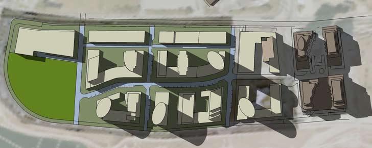
48 04 Shaping Future Development 4.6. Preferred Master Plan Based on the guidelines outlined on the previous pages a Preferred Master Plan was developed. This plan articulates the recommendations of these guidelines and highlights key design opportunities within the study area. The plan is just one way of achieving the goals of these guidelines but given the constrained nature of the sites, this Preferred Master Plan could assist land owners in developing a coordinated Precinct Plan for the area. Also contained within this section is a block-by-block description of the design criteria for the concept plan. The Humber Bay Shores FOUR The distribution of density, height, urban from and massing are structured in accordance with the urban design guidelines outlined in this document. Four zones are identified in the plan and are referred to as a) the Lake Shore Blvd. Block; b) the Mid-Block; c) the Marine Parade Block; and d) Private Open Space Area. The following detailed guidelines outline the recommended treatments in accordance with these 4 block areas (map on page 42). These guidelines should be followed in addition to the general overall guidelines from the previous sections. Village Court 40 Preferred Master Precinct Plan

49 The Humber Bay Shores FOUR 41


50 04 Shaping Future Development The Humber Bay Shores FOUR 3D view of the Preferred Master Plan, using existing as-of-right densities, existing buildings are shown in dark brown - view looking southwards 3D view of the Preferred Master Plan, using existing as-of-right densities, existing buildings are shown in dark brown - view from Gardiner Expressway at Grand Avenue. 42


51 The Humber Bay Shores FOUR 3D view of the Preferred Master Plan, using existing as-of-right densities, existing buildings are shown in dark brown - view looking northwards. 43

52 04 Shaping Future Development FOUR Block Specific Guidelines The Lake Shore Blvd. Block The blocks fronting onto Lake Shore Boulevard West are the commercially-zoned areas which average 38 metres in depth. The depth of buildings should generally allow for the provision of a 7 metre curb-to-curb laneway flanking the south side of the buildings within the boundary of the commercially zoned property. The laneway should be a publicly accessible but privately owned, continuous and dedicated laneway providing unobstructed public access to public streets at the east and west ends of the lane. The laneway should provide service and parking access for both commercial uses to the north and residential/mixeduses to the south. No vehicular access to building services or parking shall be provided from Lake Shore Boulevard West As residential uses will overlook the laneway its design should be of a high quality incorporating attractive paving, lighting and street trees where possible. Buildings abutting an adjoining development property within the Lake Shore Blvd. Block should be designed as party wall buildings and the general floor heights, massing, and rhythm of façade articulation should be consistent between adjacent developments. Building heights are recommended to be a minimum of 2 floors and a maximum of 7 floors or 27.0 metres All ground floors should be a minimum of 4.25 metres in height. The Humber Bay Shores 44 The study area was further divided into 4 district blocks, design guidelines for each block is identified in this Section and should be considered in addition to the previous general guidelines.


53 FOUR Floor-to-floor heights for commercial uses above the ground floor should generally be a minimum of 3.65 metres with the exception of hotel uses which may be a minimum of 3.0 metres floor-to-floor. A setback above the 5th floor should occur for buildings 6 and 7 floors in height. Exceptions to this setback guideline should be considered where variety in façade massing is appropriate for a minor portion of the façade width. Structured parking is generally encouraged below-grade. The design of the streetscape on the south side of Lake Shore Boulevard West should accommodate a minimum of 4.0 metres from the building wall to the curb. Street trees planted a minimum of every 5-7 metres should be provided and supported by a below-grade, connected, linear trench. Pedestrian-scaled downcast street lights should be provided in addition to downcast street lighting. Shared-use poles combining street lights and signals should be used where possible. Banner attachments should be provided on-street light poles. To support the existing and remaining commercial uses along Lake Shore Boulevard West an on-street parking lane with a width of 2.8 metres should be provided on the south side. The parking areas should be designated by the use of unit pavers. Bump-outs should be provided at all intersections and places of pedestrian crossings. Street benches, decorative planters and high quality paving should be provided as part of the streetscape treatment of Lake Shore Boulevard West. Some appropriate streetfront commercial uses for the Lake Shore Boulevard West Block include hotels, outdoor cafés, restaurants, art galleries, service retail and destination retail. Lake Shore Blvd. W. has the potential to become a street front commercial area that services the entire area. New and innovative building designs and façades will provide visual interest along the streetscape, side street patios should be created where possible. The Humber Bay Shores 45

54 04 Shaping Future Development FOUR The Humber Bay Shores The Mid-Block The Mid-Block area is located between the proposed eastwest laneway (described in section 4.3) and Street C. It is recommended that Street C have a right-of-way dimension of 18.5 metres. As illustrated in the Preferred Master Plan, Street C should be located further south relative to the location of Right-of- Way C as configured in the existing developed portion of the Humber Bay Shores area. This provides for a deeper block depth which can accommodate the tallest buildings in the area. Street C has a curved road configuration which adds complexity and interest to building form and streetscape. Tall Point Tower buildings with a maximum floor plate of 743 sq. m. are proposed to be located in the Mid-Block area. Building heights shall be based on allocated densities, with a portion of density utilized to create street-related base buildings that consistently form an active street wall along Street C as illustrated in the draft Precinct Master Plan. The minimum separating distance between buildings over 24 floors in height should be 35 metres. The minimum separating distance between buildings between floors in height should be 30 metres. The minimum separating distance between buildings 8-14 floors in height should be 25 metres. All ground floor lobby or commercial uses should be a minimum of 4.25 metres in floor-to-floor height. Floor-to-floor heights for commercial uses above the ground floor should generally be a minimum of 3.65 metres with the exception of hotel uses which may be a minimum of 3.0 metres floor-to-floor. Residential floor-to-floor heights should be a minimum of 3.0 metres Entrances to tall buildings should be expressed through a variety of possible treatments as illustrated in Section 4.4 Building Massing and Siting. Street-related buildings fronting onto the north side of Street C should be a minimum of 3 floors and maximum of 8 floors. Generally a minimum setback of 1.5 metres should occur above the 2nd or 3rd floor of street-related buildings. Exceptions to the setback guideline should be considered where variety in façade massing is appropriate for a minor portion of the façade width. A transition zone of 4 to 6 metres from the street rightof-way is required for all portions of buildings containing residential units at-grade. A diversity of building designs and shared courtyard spaces will contribute to a high quality public realm. 46


55 FOUR Residential units at-grade shall incorporate street facing entrances and a ground floor elevation that is a minimum of between 0.6 and 1.1 metres above sidewalk level. Individual expression of at-grade residential units should be designed through a variety of treatments including a rhythm of individual unit entrances, bay windows, overhangs, front terraces, setbacks and material change. Transition treatments including landscape screening for residential buildings should be designed in accordance with the Section Streets and Street Hierarchy. Access to servicing, loading, garbage rooms and parking garages for development on the north side of Street C shall, to the greatest extent possible, be located in the laneway on the north boundary of the Mid-Block. Access to servicing, loading, garbage rooms and parking garages for development on the south side of Street C shall be from the Street C, however, the width and visibility of entrances should be minimized as much as possible. The design of the streetscape on the north side of Street C and on the north-south streets should accommodate a minimum of 4.0 metres from the building wall to the curb at its tightest condition. Street trees planted a minimum of every 5-7 metres should be provided and supported by a below-grade, connected, linear trench. Pedestrian-scaled downcast street lights should be provided in addition to downcast street lighting. An on-street parking lane with a width of 2.8 metres should be provided on the north side of Street C and where possible on north-south streets. On-Street parking lanes should be designated by the use of permeable unit pavers. Bump-outs should be provided at all intersections and places of pedestrian crossings. Street benches and decorative planters should be provided as part of the streetscape treatment of Street C. Mid-block connections provide hardscaped connections within new development. Innovative landscaping and storm water management techniques should be used to minimize new infrastructure. The Humber Bay Shores 47


56 04 Shaping Future Development The Humber Bay Shores FOUR The Marine Parade Block Mid-Tall Point Tower buildings with a maximum floor plate of 743 sq. m. are proposed to be located in the Marine Parade Block area in three locations as illustrated in the Preferred Master Plan. The maximum height for Mid-Tall buildings within the Marine Parade Block is 24 floors to a maximum of 75 metres not including mechanical penthouse. Mid-Rise Terrace buildings with a maximum north-south floor plate width of 20 metres are proposed to be located in 4 locations in the Marine Parade Block area. Mid-Rise Terrace buildings range in height from 7 to 14 floors to a maximum of 45 metres. Building heights shall be based on allocated densities, with a portion of density utilized to create street-related base buildings that consistently form an active street wall along Marine Parade Drive as illustrated in the draft Precinct Master Plan. Street related base buildings facing Marine Parade Drive shall generally be a maximum of 4 floors. Generally a minimum setback of 1.5 metres should occur at the 4th floor of these street-related buildings. Exceptions to the setback guideline should be considered where variety in façade massing is appropriate for a minor portion of the façade width. All ground floor lobbies or commercial areas should be a minimum of 4.25 metres floor-to-floor height. Floor-to-floor heights for commercial uses above the ground floor should generally be a minimum of 3.65 metres with the exception of hotel uses which may be a minimum of 3.0 metres floor-to-floor. Residential floor-to-floor heights should be a minimum of 3.0 metres Entrances to Mid-Tall and Mid-Rise Terrace buildings should be expressed through a variety of possible treatments as illustrated in Section 4.4. A transition zone of 4 to 6 metres from the street right-of way is required for all portions of buildings containing residential units at-grade. Spill out space for retail and restaurants should be provided along Marine Parade Drive. Building bases along Marine Parade should be 2-3 storeys with a 1.5 metre setback above the 3rd storey to a maximum of 4.

57 FOUR Residential units at-grade shall incorporate street facing entrances and a ground floor elevation that is a minimum of between 0.6 and 1.1 metres above sidewalk level. Individual expression of at-grade residential units should be designed through a variety of treatments including a rhythm of individual unit entrances, bay windows, overhangs, front terraces, setbacks and material changes. Transition treatments including landscape screening for residential buildings should be designed in accordance with Section 4.3. Access to servicing, loading, garbage rooms and parking garages shall be from Street C located on the north boundary of the Marine Parade Block. No vehicular access to building services or parking shall be provided from Marine Parade Drive. The design of the streetscape on the north side of Marine Parade Drive should accommodate a minimum of 6.0 metres from the building wall to the curb at its tightest condition. The design of the streetscape on the north-south streets in the Marine Parade Block should accommodate a minimum of 4.0 metres from the building wall to the curb at its tightest condition. Street trees planted a minimum of every 5-7 metres should be provided and supported by a below-grade, connected, linear trench. Pedestrian-scaled downcast street lights should be provided in addition to downcast street lighting. An on-street parking lane with a width of 2.8 metres should be provided on the north side of Marine Parade Drive and where possible on north-south streets. On-Street parking lanes should be designated by the use of permeable unit pavers. Bump-outs should be provided at all intersections and places of pedestrian crossings. Street benches and decorative planters should be provided as part of the streetscape treatment of Marine Parade Drive. Residential uses should be located above an active ground floor. The Humber Bay Shores 49

58 04 Shaping Future Development FOUR Private Open Space Block The Private Open Space Block is identified as parkland in the Official Plan. The requirements for parkland in this specific area should be reviewed as part of a development application for the site and would need to conform to parkland dedication requirements. Outlined below are the guidelines specific to the design buildings and open spaces within this area. All applicable guidelines for public realm, streets and street hierarchy that are outlined in this document should also apply to any development that is to occur within this area. Taller buildings, if allowed, are to have a maximum floor plate of z sq. m. Parkland dedication in the area should be amalgamated into a single open space. Key views through the site towards the Lake and the Humber Bay Parks should be maintained and observed. Any new development proposed for the area would have to clearly demonstrate the key view corridors. Street related base buildings facing Marine Parade Drive shall generally be a maximum of 2-3 floors. Generally a minimum setback of 1.5 metres should occur at the 4th floor of these street-related buildings. Exceptions to the setback guideline should be considered where variety in façade massing is appropriate for a minor portion of the façade width. All ground floor lobby or commercial area should be a minimum of 4.25 metres floor-to-floor height. Floor-to-floor heights for commercial uses above the ground floor should generally be a minimum of 3.65 metres with the exception of hotel uses which may be a minimum of 3.0 metres floor-to-floor. Residential floor-to-floor heights should be a minimum of 3.0 metres Entrances to taller buildings should be expressed through a variety of possible treatments as illustrated in Section 4.4. A transition zone of 4 to 6 metres from the street right-of-way is required for all portions of buildings containing residential units at-grade. Residential units at-grade shall incorporate street facing entrances and a ground floor elevation that is a minimum of between 0.6 and 1.1 metres above sidewalk level. Individual expression of at-grade residential units should be designed through a variety of treatments including a rhythm of individual unit entrances, bay windows, overhangs, front terraces, setbacks and material change. Transition treatments including landscape screening for residential buildings should be designed in accordance with Section 4.3. Access to servicing, loading, garbage rooms and parking garages shall be from a continued Street C. No vehicular access to building services or parking shall be provided from Marine Parade Drive. The Humber Bay Shores 50 The Private Open Space Block is located along the western curve of Marine Parade Drive. The study area is heavily vegetated, existing trees should be retained where possible.


59 FOUR The design of the streetscape on the north side of Marine Parade Drive should accommodate a minimum of 6.0 metres from the building wall to the curb at its tightest condition. A combination of public and private pedestrian connections should be established through the entire site. The design of the streetscape on the north-south streets should accommodate a minimum of 4.0 metres from the building wall to the curb at its tightest condition. Street trees planted a minimum of every 5-7 metres should be provided and supported by a below-grade, connected, linear trench. Pedestrian-scaled downcast street lights should be provided in addition to downcast street lighting. An on-street parking lane with a width of 2.8 metres should be provided on where possible. On-street parking lanes should be designated by the use of permeable unit pavers. Bump-outs should be provided at all intersections and places of pedestrian crossings. Street benches and decorative planters should be provided as part of the streetscape treatment of any new streets. Built form should transition changes in height and where possible should be articulated with exterior staircases and ramps. Completing the road network would create an interconnected community structure. A cul-de-sac design would minimize roads and would increase availability of land for a large public open space but would also limit accessibility through the site. There is a large transition is height that is currently bermed or contained with retaining walls. This option would create another connection to Marine Parade Drive but has to be further investigated as the changes in elevation might not make it feasible. The Humber Bay Shores 51
60 05 Implementation FIVE The Humber Bay Shores Next Steps Policy Updates and Amendments The City By-laws, the Toronto Official Plan, and the Secondary Plan do not reflect the recommendations of these Urban Design Guidelines. It is recommended that the policy framework be updated to reflect the recommendations of this document. As to present a consistent vision for the Humber Bay Shores Area Development of Land Owner Precinct Plan A Land Owner Precinct Plan should be developed by the study area land owner and their representatives, in consultation with the City. This precinct plan is intended to guide future development and development applications. The Precinct Plan must reflect the recommendations of this document and should refer to the Preferred Master Plan as a guide. The Preferred Master Plan demonstrates how the area can be developed through cooperation and coordination between land owners. Consolidation is not precluded within the Preferred Master Plan but the existing land ownership configurations were observed. A demonstration of ongoing coordination between study area land owners should be required for future development approvals City of Toronto Design Review Panel Review The final Urban Design Guidelines for Humber Bay Shore should be presented to the Design Review Panel for their comment and consideration. The Land Owner Precinct should also be presented to the committee as the tool to that will guide coordination between properties as future development applications come forward Existing Motel Strip Urban Design Guidelines The Motel Strip Urban Design Guidelines that are superseded by this document should be reviewed, evaluated and if applicable rescinded Recommended Official Plan, Secondary and Zoning Amendments In order to coordinate the existing policy framework with the Updated Humber Bay Shores Urban Design Guidelines the following policy and implementation issues should be addressed: Coordination of Land Use Designations; Existing land uses including properties with a hold designation should be evaluated and updated; Maintaining existing density allocations; Determination of Public Open Space Requirements; Assessment of On-Street Parking Locations; Height Amendments; Introduction of a Continuous Rear Lane System along Lake Shore Boulevard West; and, Introduction of Public Parking Spaces in New Development Updates and Reviews A periodic review of these urban design guidelines, the Preferred Master Plan and the Land Owners Precinct Plan should be undertaken at the completion of each substantial portion of development Glossary of Key Terms Preferred Master Plan - The concept plan developed to reflect these Humber Bay Shore Urban Design Guidelines Land Owners Precinct Plan - A precinct plan for the study area that is developed through a coordinated and collaborative process between land owner, based on these guidelines,. The precinct plan is to be accepted by the City and review by the City of Toronto Design Review Plan. The Preferred Master Plan can be the basis for the Land Owners Precinct Plan Document References City of Toronto Green Development Standard City of Toronto Tall Building Guidelines City of Toronto Standards for Local Roads index.htm

61 Appendices The Humber Bay Shores APPENDICES a. Charrette Summary - Nov 8, 2007 b. Design Review Panel Minutes - Nov 22,

62 Prepared by BMI/Pace Working Together... Humber Bay Shore Urban Design Guideline Update & Public Realm Plan CHARRETTE SUMMARY REPORT November 8, 2007
63
64 Table of Contents 1.0 Introduction Visioning Exercise 4 Group 1: concept & presentation Group 2: concept & presentation Group 3: concept & presentation Group 4: concept & presentation Group 5: concept & presentation Group 6: concept & presentation 3.0 Concluding Remarks Appendix 18


65 2 1.0 Introduction This document is a summary of the Humber Bay Shores Design Charrette held on November 8, The charrette provided an important opportunity for the City and consultant team to consult with key stakeholder about their vision for the Humber Bay Shores area and the remaining lands to be developed. The objective of the charrette was to gather feedback and ideas on the development that has happened to date and the successes of existing policy framework as well as to determine guiding principles for the remaining developable land. The charrette scope was designed to assist in the review and update of the existing Urban Design Guidelines and the Public Realm Plan. The charrette was attended by area residents, land owners, land owner representatives, city staff and the consulting team lead by BMI/Pace. Approximately fifty participants attended and participated in the days events. The day s events followed the schedule outlined below (a detailed charrette schedule in located in appendix A): Introductions Context and Background Presentations Post-It note Visioning Exercise Site Tour Lunch (provided) First Exercise: A Framework for the Future Second Exercise: Area Visioning and Development Concepts Group Presentations A Visioning Post-It notes exercise was conducted by BMI/Pace after Context Presentations. Each participant was asked to write their top three issues or ideas for the area. The participant s top priorities are as follows: #1- Building Design Allow for taller, slender, well-designed buildings to achieve a high quality public realm, new public open spaces and to facilitate views to the lake # 2- Public Open Spaces Build on the strength of the existing open spaces with new connections including new public spaces within new developments # 3- Pedestrian Realm Increase overall pedestrian connections throughout the area especially between Lake Shore Boulevard West and Marine Parade Drive Image of Study Area looking North Image of Secondary Plan area looking east BMI/Pace Nov 2007


66 # 4- Street Design Create high quality streetscapes with well designed ground floors and retail at grade where appropriate, with increased activity along Marine Parade Drive #5- Traffic and Transportation Minimize curb cuts and private access along Lake Shore Boulevard West to minimize traffic impacts Other Key Comments Maximize views Consolidate properties Accommodate existing land uses In the afternoon, the participants were divided in to six groups to undertake a visioning exercise. Each of groups was provided with aerial photographs, key maps and other materials to be used for the duration of the charrette. In the first exercise A Framework for the Future groups discussed and developed their recommendations for key guiding principles, key opportunities, transportation framework, access and egress, key views and green spaces. Charrette Study Area In the second exercise Area Visioning and Development Concepts groups focused on developing site plan designs and typical block layouts, street design and hierarchy, public open space design, building design: height, massing, architectural characters, etc. At the end of the day, each group presented their sketches, plans and sections and summarized their common overviews. BMI/Pace conclude the charrette by presenting the summary of Post-It notes, concluding remarks and next step schedules The Urban Design Guidelines Update and Public Realm Plan is anticipate for completion early 2008, the study s recommendations are intended to shape future growth/redevelopment and potential civic improvements and will identify an implementation strategy for achieving a high quality public and private realm for the remaining Humber Bay Shores Lands. Working Group Image Charrette Summary Report - Humber Bay Shores Urban Design Guideline Update and Public Realm Plan 3


67 4 2.0 Visioning Exercises The following section provides a summary of the recommendations made by each of the charrette groups Group 1 Summary Group 1 focused on the west end of the site suggesting a new configuration of open space. The group proposed a north-south open space corridor. The new configuration of this open space would allow for better integrated development at the surrounding sites. This group also identified the on-street parking as a key issue for successful commercial uses along Lake Shore Blvd. West. EXERCISE 1: A FRAME WORK FOR THE FUTURE Key Direction Strategic configuration of open space at the west end North-south open space corridor as opposed to flanking Marine Parade Is Marine Parade angular plane setback necessary? Commercial at 38 metre depth is not a problem BUT could be considered differently Commercial allocation 500,000 sq. ft. need on-street parking could be off-peak if commuter traffic is an issue Examine the cross section of Lake Shore Where can we get 2.8 metres for on-street parking from streetcar row or setback of properties? Current land ownership Potential relocation of open spaces BMI/Pace Nov 2007


68 EXERCISE 2: AREA VISIONING & DEVELOPMENT CONCEPTS Key Directions Rear vehicular access to commercial not from Lake Shore Blvd. West Don t replicate the park flanking Marine Parade Drive Dip right of way C to the south to facilitate development site on the west side of study area Taller building along Lake Shore Blvd. West and lower Building along Marine Parade Drive Potential block confi guration 1 Potential block confi guration 2 Charrette Summary Report - Humber Bay Shores Urban Design Guideline Update and Public Realm Plan 5

69 6 Group 2 Summary Group 2 focused on creating a pedestrian friendly environment. They suggested minimizing the private access along Lake Shore Blvd. West while providing more public accesses to waterfront. The group identified the appropriate signage, street furniture and multi-seasonal uses as critical to achieve pedestrian friendly streets. This group also suggested Monarch s building as the most important landmark at the site. Other buildings should step down toward Marine Parade Drive. EXERCISE 1: A FRAME WORK FOR THE FUTURE Key Direction Signage and way finding is critical Co-ordination of common vision for the corner area No private access along Lake Shore (Minimize curb cuts) Green landscaped street (with trees) Multi-seasonal use of park area Pedestrian friendly waterfront connections are recommended Streetscape at Marine Parade Drive should be improved by providing more active uses Site analysis BMI/Pace Nov 2007

70 EXERCISE 2: AREA VISIONING & DEVELOPMENT CONCEPTS Key Direction Buildings should tier up from low-rise on Marine Parade Drive Monarch should be the highest building at site (37 storeys) Buildings should step down from this height A East-West access road should be considered as a main access to site Another East-West service road should be considered for commercial use along Lake Shore Blvd. West Terraced low rise buildings are preferred along Marine Parade Drive North-South streets should be landscaped and combined with public space Continuous building street wall along Marine Parade Drive Potential block confi guration Charrette Summary Report - Humber Bay Shores Urban Design Guideline Update and Public Realm Plan 7

71 8 Group 3 Summary Group 3 focused on green. They suggested park spaces within blocks linking to the waterfront and most of the residential units facing open space and waterfront. This team also thought a variety of uses along Marine Parade Drive was critical for active street life. EXERCISE 1: A FRAME WORK FOR THE FUTURE Key Direction Marine Parade Drive should allow for varied uses such as parking, markets, festivals etc and should not be dominated by cars. Marine Parade Drive and waterfront park should be programmed with year round uses such as Jazz festival, book market and art exhibition in the park etc. Park space within the block should link to the waterfront Grade access/related units should face the park spaces Servicing, commercial access and resident access should be thoroughly resolved and considered Pedestrian/bicycle friendly development is a must Potential character of the site BMI/Pace Nov 2007
")

72 EXERCISE 2: AREA VISIONING & DEVELOPMENT CONCEPTS Key Direction The orientation of blocks is important An internal east-west road is needed for service and parking Access to residential units ( condo/townhomes) preferred facing open space or waterfront Regular block and open space pattern was recommended Potential block orientation Potential block layout Charrette Summary Report - Humber Bay Shores Urban Design Guideline Update and Public Realm Plan 9

73 10 Group 4 Summary Group 4 focused on the 38m commercial strip along Lake Shore Blvd. West. The group suggested other uses such as parking structures with retails at ground level. They also suggested integrating the school site with community amenity areas. The team also identified preferred high-rise and low-rise zones in the site. In this team s vision, North-south streets are more important than east-west streets. These streets should be well landscaped with full movements. More over, the group thought the Village-Court should serve as a vibrant retail street rather than just a green space. EXERCISE 1: A FRAME WORK FOR THE FUTURE Key Direction Integrate school site (if required) with community amenities in a joint-use facility. Require double sided retail uses along Lake Shore Blvd. West with on street parking, if retail is expected. Consider relocation of TTC loop. Improve the quality of existing open space with better programming and amenities Respect and incorporate the heritage (i.e. past motel use) of the site Consider other uses on Lake Shore Blvd. West such as parking structures with retail at ground as opposed to pure commercial uses Site analysis and potential use along Lake Shore Blvd. West BMI/Pace Nov 2007


74 EXERCISE 2: AREA VISIONING & DEVELOPMENT CONCEPTS Key Direction Mid-block east-west street may not be required if north-south streets are closely spaced and have a strong character Perhaps Village-Court could serve as a retail street with shops along both sides leading to a plaza at waterfront View is an important issue of the site. Design of building should allow view toward & from the lake. Buildings visible from Gardiner requires high quality of architecture Maximize the space between buildings. Local roads need full movement at Lake Shore Blvd Minimum separation of high-rise building is 30m High-rise zone should be considered to provide flexibility for design of towers. Potential block confi guration - option 1 Potential block confi guration - option 2 Charrette Summary Report - Humber Bay Shores Urban Design Guideline Update and Public Realm Plan 11

75 12 Group 5 Summary Group 5 expressed the importance of pedestrian accesses to waterfront and suggested making entire development pedestrian friendly. The group also recommended incorporating sustainable elements such as rooftop garden and making Park Lawn more park like. In this group s vision, there should be a variety of built forms with different heights and styles. These buildings should tier up from the waterfront with at least 30m separations. EXERCISE 1: A FRAME WORK FOR THE FUTURE Key Direction Provide street furniture at public open space Make Park Lawn Road more park like Create green area with year-round uses such as playgrounds, skating rinks, markets and other activities Make entire development pedestrian friendly Improve the transit and traffic infrastructures before planning major development Consider school site at west side of the site Have landscaping and retail on both side of Lake Shore Blvd. West Site analysis and potential use along Lake Shore Blvd. West BMI/Pace Nov 2007


76 EXERCISE 2: AREA VISIONING & DEVELOPMENT CONCEPTS Key Direction Buildings should tier up from the waterfront. Variety of height/ styles is preserved The space between buildings should be about 30-40m. Rooftop gardens and other sustainable elements should be incorporated 4-6 storey high buildings are preferred along Marine Parade Drive Theme based public art and green spaces is recommended Potential block and building confi guration Potential road section of Marine Parade Drive Charrette Summary Report - Humber Bay Shores Urban Design Guideline Update and Public Realm Plan 13


77 14 Group 6 Summary Group 6 concentrated on the importance of street walls and podiums. The group felt the continuous podiums would create an unsightly wall blocking the views towards waterfront. They suggested pushing buildings back from streets with varying setbacks, which would create opportunities for sidewalk café, restaurants, etc and bring active street life. EXERCISE 1: A FRAME WORK FOR THE FUTURE Key Direction Development should incorporate community services and ensure the continuity of open public space. Number of streets could be reduced through private-to-private lots with public easements Community services could be integrated in school site Is Monarch to be the central iconic development in terms of height, or can there are buildings over 37 stories? The Lake Shore Blvd. West street edge does not need to be continuous; there could be setbacks of varying depth. This would create opportunities for sidewalk cafés and weather protection Make streets more narrow and more pedestrian friendly Site analysis Potential road sections BMI/Pace Nov 2007


78 EXERCISE 2: AREA VISIONING & DEVELOPMENT CONCEPTS Key Direction Continuous podiums can create an unsightly wall Variety of building types and unique landmarks North-South streets for access, East-West streets for service connections Prefer 12-15m podium height Consideration of 38m zone with mix of uses Location of central area should be rethought Lower buildings along Lake Shore; taller buildings along Marine Parade Drive Potential block and building confi guration Potential block and building confi guration Charrette Summary Report - Humber Bay Shores Urban Design Guideline Update and Public Realm Plan 15
79 Concluding Remarks The future success of the Humber Bay Shores Areas depends largely on the collaboration between the City of Toronto and area landowners and their commitment to development that contributes to a unified vision for the area. The city itself can also demonstrate its commitment to renewal in the area though investment in the public realm and support for desirable proposals The ideas developed over this charrette have been summarized in this document. These ideas are intended to guide future discussion with the City and the development of the urban design guideline update. This charrette provided an opportunity for a variety of stakeholders to express their views on what constitutes desirable development in the area. The intent of this charrette was to shape the long term vision of the area, not to develop finalized designs, and this session was merely one step in the process of engaging landowners and other stakeholders in a discussion about important issues within the area. BMI/Pace Nov 2007
80 4.0 Appendix The Charrette Groups 1 Calvin Brook (BMI) Sol Wassermulh (Page + Steele) Nick Rassenti (Page + Steele) Larry Field (TRCA) Sal Vitiello (E.I. Richmond Architects Ltd.) Ted Shore (Quadrangle Architects) Moiz Behar (2175 Lake Shore) Steven Warsh (S&R Development) Stephen Fagyas (Planner) Bob Johnson (Landowner) 2 David McKillop (City of Toronto) Jessica Hawes (BMI) Mike Wehkind (City of Toronto) Nancy Gaffney (TRCA) Gabriel DiMartino (Graywood) Shirley Hitchcock (Resident) 3 Nathaniel Llyod (BMI) Brian Mercer (City of Toronto) Victor Gottwald (City of Toronto) Mary-Ann George (TTC) Frank Vona Daniel Guizzetti (Empire) Angie Chiu (Resident) Josie Petrolo (Resident) 4 Lorna Day (City of Toronto) Zhongwei Shi (BMI) Antonella Nicaso (City of Toronto) Al Smithies (City of Toronto) Mario Silva (TDSB) Ed Gadzala (Hillcrest) David Gadzala (Hillcrest) Kurt Franklin (Weston Consulting) Peter Swinton 5 Emilia Floro (City of Toronto) Adriana Gomes (City of Toronto) Laura Nash (Resident) Leo Blindenbach (Resident) 6 Anne McIlroy (BMI) Edna Cuvin (City of Toronto) Karen Harris (City of Toronto) Enzo Corazza (Monarch s Architect) Craig Hunter (Monarch s Planner) Thanh Le (City of Toronto) Lino Pellicano Ken Young (Landowner) Charrette Summary Report - Humber Bay Shores Urban Design Guideline Update and Public Realm Plan 17
81 18 The Charrette Schedule 11/28/2007 Schedule prepared by BMI DESIGN CHARRETTE SCHEDULE November 8, 2007 Urban Design Guidelines Update and Public Realm Plan Humber Bay Shores 9:00 9:15 Sign-In and Charrette Team Allocation 9:20 9:35 Introductions (City Staff) 9:35 9:40 Opening Remarks 9:40 9:50 Post-It Note Exercise (BMI) Name your top 3 priorities for redevelopment of the remaining Humber Bay Shore Lands 9:50 10:50 Context and Background Presentations Area context and background (City Staff) How the charrette will work: Overview of Agenda (BMI) Best practices: successful examples from other places (BMI) Development opportunities and constraints (BMI) Transportation overview and update (City Staff) 10:50 11:20 Land Owner Site Concept Presentations 5 minutes each 11:20 12:15 Site Tour (Groups 1, 2 and 3 with Cal and Groups 4, 5, and 6 with Anne) 12:15 12:45 LUNCH Teams assemble at their stations 12:45 2:00 First Team Exercise: A Framework for the Future Key guiding principles Key opportunities Transportation framework, access and egress Key views Green spaces Pedestrian and cyclist connections 2:00 4:00 Second Exercise: Area Visioning and Development Concepts Sustainable site plan design and block layouts Streetscape design and hierarchy Public open space design Building design: height, massing, architectural characters Public art & green spaces 11/28/2007 Schedule prepared by BMI Groups are to prepare for presentation: Key guiding principles Key opportunities Plans Sections Sketches Development criteria: What is required to make the area a great place? 4:00 5:00 Team Presentations: Frameworks for the Future Each group presents overview for 5-10 minutes Final comments 5:00 5:15 Concluding Remarks and Next Steps BMI/Pace Nov 2007


 Introductions Context and Background Presentations Post-It note Visioning Exercise Site Tour Lunch")
82 The Charrette Invitation INVITATION TO A DESIGN CHARRETTE THE HUMBER BAY SHORE URBAN DESIGN GUIDELINE UPDATE AND PUBLIC REALM PLAN As local landowners/key stakeholders the City of Toronto invites you to participate in a day long Design Charrette and Visioning exercise for the Humber Bay Shores Area. The Charrette will provide a unique opportunity to shape the long term vision of the area. The charrette will gather feedback and ideas to assist in the review and update of the existing Urban Design Guidelines and the development of a Public Realm Plan that will shape future area development and potential civic improvements. Several key opportunities that the Charrette will address include: Review and update existing Urban Design Guidelines. Optimize and enhance existing open spaces. Harmonize new development with existing uses. Improve the pedestrian environment. How new buildings can be best integrated on the remaining lands. Where public spaces can be created. Improve existing open spaces with better connections. Where landscaping should happen and green strategies This is your opportunity to contribute to the vision for the Humber Bay Shores Urban Design Guidelines and Public Realm Plan. The Charrette is scheduled for Thursday November 8, The Charrette INVITATION TO A DESIGN CHARRETTE The Design Charrette will include presentations highlighting the study area and examples of successful areas from similar communities. Discussion groups of 6-8 will be formed, each with a facilitator, and asked to discuss the opportunities outlined above. The discussion will be aided by plans of the study area. The resulting input will be summarized to guide the work of the Consultant Team for the remainder of the project. The preliminary schedule for the Charrette is as follows: Draft Schedule: (9:00 am to 5:00 pm) Introductions Context and Background Presentations Post-It note Visioning Exercise Site Tour Lunch (provided) First Exercise: A Framework for the Future Second Exercise: Area Visioning and Development Concepts Third Exercise: Site Specific Concepts: Presentation Materials Group Presentations As space is limited please confirm your attendance with the City by Nov 2, 2007 Emilia Floro Senior Urban Designer, City of Toronto City Planning, Urban Design tel fax efloro@toronto.ca THE HUMBER BAY SHORE URBAN DESIGN GUIDELINE UPDATE AND PUBLIC REALM PLAN Map of Charrette Study Area Charrette Summary Report - Humber Bay Shores Urban Design Guideline Update and Public Realm Plan 19
The Humber Bay Shores. Urban Design Guidelines Update and Public Realm Plan. July, 2008
 Urban Design Guidelines Update and Public Realm Plan July, 2008 prepared by Brook McIlroy Planning and Urban Design / Pace Architects Content i EXECUTIVE SUMMARY KEY RECOMMENDATIONS iii ONE INTRODUCTION
DRAFT Northeast Quadrant of Kipling Avenue and Highway 7 DRAFT AUGUST 29, Goals Land Use. The goals of this Plan are to:
 AUGUST 29, 2017 12.15 Northeast Quadrant of Kipling Avenue and Highway 7 12.15.1 Goals 12.15.2 Land Use The goals of this Plan are to: 12.15.2.1 General Provisions: a) Ensure the development of a compact
East Bayshore Road Neighbourhood
 East Bayshore Road Neighbourhood Northridge Property Management Urban Design Brief 3195 East Bayshore Road City of Owen Sound January 2016 East Bayshore Road Neighbourhood Northridge Property Management
Clairtrell Area Context Plan
 Clairtrell Area Context Plan March 2005 Urban Development Services City Planning Contents 1. Introduction... 4 2. Development Structure... 6 2.1 Streets... 7 2.1.1 Sheppard Avenue and Bayview Avenue...
Uptown Rideau Street Secondary Plan [Amendment #166, January 12, 2016]
![Uptown Rideau Street Secondary Plan [Amendment #166, January 12, 2016]](/thumbs/76/73760497.jpg "Uptown Rideau Street Secondary Plan [Amendment #166, January 12, 2016]") [Amendment #166, January 12, 2016] The policies of this Secondary Plan are in effect, save and except for the property at 560 Rideau Street, for which there remains a site specific appeal to this Secondary
[Amendment #166, January 12, 2016] The policies of this Secondary Plan are in effect, save and except for the property at 560 Rideau Street, for which there remains a site specific appeal to this Secondary
ELMVALE ACRES SHOPPING CENTRE MASTER PLAN
 ELMVALE ACRES SHOPPING CENTRE MASTER PLAN Contents 1.0 INTRODUCTION... 2 2.0 LOCATION... 2 3.0 EXISTING CONTEXT... 2 4.0 VISION & GUIDING PRINCIPLES... 2 5.0 LAND USE AND BUILT FORM... 4 5.1 St. Laurent
Urban Design Manual PLANNING AROUND RAPID TRANSIT STATIONS (PARTS) Introduction. Station Study Areas
 Introduction. Station Study Areas") 111111 PLANNING AROUND RAPID TRANSIT STATIONS (PARTS) Introduction The ION rapid transit system will link Waterloo, Kitchener and Cambridge through a central transit corridor (CTC). There are a number
111111 PLANNING AROUND RAPID TRANSIT STATIONS (PARTS) Introduction The ION rapid transit system will link Waterloo, Kitchener and Cambridge through a central transit corridor (CTC). There are a number
QUEEN-RIVER SECONDARY PLAN
 34 QUEEN-RIVER SECONDARY PLAN 34. QUEEN RIVER SECONDARY PLAN 1. INTRODUCTION The Queen-River area is approximately 6.4 hectares and is located at the eastern edge of the Downtown as shown on Map 34-1.
Official Plan Review: Draft Built Form Policies
 PG.30.1 REPORT FOR ACTION Official Plan Review: Draft Built Form Policies Date: May 15, 2018 To: Planning and Growth Management Committee From: Chief Planner and Executive Director, City Planning Division
URBAN DESIGN BRIEF. 2136&2148 Trafalgar Road. Town of Oakville
 URBAN DESIGN BRIEF 2136&2148 Trafalgar Road Town of Oakville Prepared By: METROPOLITAN CONSULTING INC For 2500674 Ontario Inc November 2016 TABLE OF CONTENTS Page No. 1.0 Introduction/Description of Subject
Complete Neighbourhood Guidelines Review Tool
 Complete Neighbourhood Guidelines Review Tool Prepared By: City of Regina Planning Department October 2014 Page 1 of 14 Community Development Review Checklist for Secondary Plans and Concept Plans The
Workshop 3. City of Burlington Waterfront Hotel Planning Study. September 14, The Planning Partnership
 Workshop 3 City of Burlington Waterfront Hotel Planning Study September 14, 2017 The Planning Partnership The Waterfront Hotel Planning Study 01 The Brant & Lakeshore Planning Study will establish a Strategic
appendix and street interface guidelines
 appendix five: building and street interface guidelines appendix 5 building and street interface guidelines BOULEVARDS Boulevards are generally characterized by higher levels of traffic movement at higher
5.1 Site Plan Guidelines
 5. Community Core Guidelines Development of the Community Core will take place by plan of subdivision and site plan approval. It will occur in a phased manner that will reflect the timing of residential
Wide asphalt driveway abutting school property. garage built with incompatible materials, too close to park. incompatible fencing materials
 Wide asphalt driveway abutting school property incompatible fencing materials garage built with incompatible materials, too close to park Lack of plantings as a buffer between private property and open
SCHEDULE 'A' TO BY-LAW as Amended by AMENDMENT NO. 90 TO THE WHITBY OFFICIAL PLAN
 SCHEDULE 'A' TO BY-LAW 6413-10 as Amended by 6553-11 AMENDMENT NO. 90 TO THE WHITBY OFFICIAL PLAN SECTION A: GROWTH PLAN CONFORMITY PURPOSE: LOCATION: BASIS: The purpose of this Amendment is to: conform
CONTENTS 8.0 LAND USE 8.1 GENERAL LAND USE 8.2 RESIDENTIAL 8.3 MIXED USE 8.4 COMMERCIAL 8.5 EMPLOYMENT LANDS
 8-2 Land Use 8.0 LAND USE CONTENTS 8.1 GENERAL LAND USE 8.1.1 Uses provided for in all Land Use Designations 8.1.2 Uses prohibited in Hazardous Lands, Hazardous Sites and Special Policy Areas 8.1.3 Uses
1.0 Purpose of a Secondary Plan for the Masonville Transit Village
 Report to Planning and Environment Committee To: Chair and Members Planning & Environment Committee From: John M. Fleming Managing Director, Planning and City Planner Subject: Masonville Transit Village
Urban Design Guidelines Townhouse and Apartment Built Form
 Urban Design Guidelines Townhouse and Apartment Built Form Town of Wasaga Beach Table of Contents 1. Introduction 1.1. Purpose 1.2. Urban Design Principles 1.3. Application of Guidelines 2. Site Design,
The Master Plan Framework
 The Master Plan Framework The East Harbour Master Plan advances the development of 60 acres of former industrial lands east of the Don River. The Master Plan outlines a vision for a vibrant, transit-oriented
Regency Developments. Urban Design Brief. Holyrood DC2 Rezoning
 Regency Developments Urban Design Brief Holyrood DC2 Rezoning Stantec Consulting Ltd. 7-31-2017 1. Overview Regency Developments intends to rezone the lands located at 8510 and 8511 93 Avenue, within the
New-Cast Mixed-use Development Proposal King Street West, Newcastle, Ontario
 URBAN DESIGN BRIEF New-Cast Mixed-use Development Proposal King Street West, Newcastle, Ontario TABLE OF CONTENTS: 1.0 Executive Summary 2.0 Creating Vibrant and Sustainable Urban Places: Excerpts from
Mark-up of the effect of the proposed Bronte Village Growth Area OPA No.18 on the text of section 24, Bronte Village, of the Livable Oakville Plan
 Mark-up of the effect of the proposed Bronte Village Growth Area OPA No.18 on the text of section 24, Bronte Village, of the Livable Oakville Plan Notes: This document is provided for information purposes
[PLANNING RATIONALE] For Site Plan Control and Lifting of Holding Zone By-Law 101 Champagne Avenue. May 23, 2014
![[PLANNING RATIONALE] For Site Plan Control and Lifting of Holding Zone By-Law 101 Champagne Avenue. May 23, 2014](/thumbs/75/71599615.jpg "[PLANNING RATIONALE] For Site Plan Control and Lifting of Holding Zone By-Law 101 Champagne Avenue. May 23, 2014") [PLANNING RATIONALE] For Site Plan Control and Lifting of Holding Zone By-Law 101 Champagne Avenue May 23, 2014 Contents 1.0 Introduction... 2 2.0 Site Context... 2 2.1 Adjacent Uses... 2 Figure 1: Site
[PLANNING RATIONALE] For Site Plan Control and Lifting of Holding Zone By-Law 101 Champagne Avenue May 23, 2014 Contents 1.0 Introduction... 2 2.0 Site Context... 2 2.1 Adjacent Uses... 2 Figure 1: Site
WINDSOR GLEN DESIGN GUIDELINES
 WINDSOR GLEN DESIGN GUIDELINES Adopted by Council, 2006 WINDSOR GLEN REDEVELOPMENT DESIGN GUIDELINES August 2006 1.0 Master Plan Organization For this area of the Coquitlam Town Centre, a mix of high,
Highland Village Green Design Guidelines
 Highland Village Green Design Guidelines Publishing Information Title Highland Village Green Design Guidelins Author The City of Calgary Status DRAFT - Proposed document subject to changes Additional Copies
URBAN DESIGN BRIEF URBAN DESIGN BRIEF 721 FRANKLIN BLVD, CAMBRIDGE August 2018
 URBAN DESIGN BRIEF URBAN DESIGN BRIEF 721 FRANKLIN BLVD, CAMBRIDGE August 2018 DESIGN BRIEF CONTENTS PART A 1.0 INTRODUCTION 2.0 DESCRIPTION & ANALYSIS OF SITE CONTEXT 3.0 DESIGN CONSTRAINTS AND OPPORTUNITIES
Welcome. Walk Around. Talk to Us. Write Down Your Comments
 Welcome This is an information meeting introducing the applications for proposed redevelopment of the Yorkdale Shopping Centre site at 3401 Dufferin Street and 1 Yorkdale Road over the next 20+ years,
Public Consultation Summary: Lakeview Place Making Workshop January 30, 2008.
 Page 1 of 11 Public Consultation Summary: Lakeview Place Making Workshop January 30, 2008. 1.0 Introduction: On January 30, 2008 the City of Mississauga, in conjunction with the consulting team of Brook
Derry Green Corporate Business Park
 Town of Milton Derry Green Corporate Business Park Urban Design Guidelines BMI/Pace - June 2010 Draft 3 Prepared by: Brook McIlroy Planning + Urban Design / Pace Architects Suite 300-51 Camden Street Toronto,
PUBLIC RIGHT-OF-WAY IN THIS CHAPTER PUBLIC REALM
 PUBLIC RIGHT-OF-WAY This section provides design guidelines for improvements in the public right-of-way. The public right-of-way refers to streets, sidewalks, non-vehicular thoroughfares, parks and greenways
Cit of Kitchener Ur 6 an Design Manual PARTA. Desi n for _--::
 Cit of Kitchener Ur 6 an Design Manual Date PARTA Year ) Desi n for k Nodes Corridors _--:: Section Page 01 of 12 2 INTRODUCTION Purpose & Application Nodes and Corridors have been identified as key intensification
King-Spadina Secondary Plan Community Consultation Meeting. Michelle Knieriem, City Planner October 11, 2017
 King-Spadina Secondary Plan Community Consultation Meeting Michelle Knieriem, City Planner October 11, 2017 Agenda 6:30 Welcome 6:35 Presentation 7:15 Question and Answer Session 8:15 Closing Remarks HOW
Hamilton Pier 7&8 Draft Urban Design Plan
 Hamilton Pier 7&8 Draft Urban Design Plan Public Open House October 29, 2015 Contents 1. Study Overview 2. Area Design Goals 3. Urban Structure 4. Public Realm 5. Urban Design Plan Options 6. Next Steps
Tel: (705) Fax: (705)
 Fax: (705)") 521 and 525 Essa Road City of Barrie Tel: (705) 812-3281 Fax: (705) 812-3438 Email: INFO@IPSCONSULTINGINC.com 1 5 0 D U N L O P S T R E E T E A S T, S U I T E 2 0 1, B A R R I E O N T A R I O L 4 M 1 B
521 and 525 Essa Road City of Barrie Tel: (705) 812-3281 Fax: (705) 812-3438 Email: INFO@IPSCONSULTINGINC.com 1 5 0 D U N L O P S T R E E T E A S T, S U I T E 2 0 1, B A R R I E O N T A R I O L 4 M 1 B
Figure 3-1: Public Realm Plan
 3 Public Realm Figure 3-1: Public Realm Plan 3.1 Public Realm Concept The public realm concept for the Little Mountain site integrates a clear and accessible movement network with public spaces for social
WEST LOOP DESIGN GUIDELINES CHECKLIST
 WEST LOOP DESIGN GUIDELINES CHECKLIST Section 1.0 General Strategies 1.1 DESIGN EXCELLENCE: ENCOURAGE HIGH QUALITY AND INNOVATIVE DESIGN OF NEW BUILDINGS WITHIN THE WEST LOOP WITHOUT BEING PRESCRIPTIVE
FORMER CANADIAN FORCES BASE (CFB) ROCKCLIFFE SECONDARY PLAN. Official Plan Amendment XX to the Official Plan for the City of Ottawa
 ROCKCLIFFE SECONDARY PLAN. Official Plan Amendment XX to the Official Plan for the City of Ottawa") FORMER CANADIAN FORCES BASE (CFB) ROCKCLIFFE SECONDARY PLAN Official Plan Amendment XX to the Official Plan for the City of Ottawa 1 INDEX THE STATEMENT OF COMPONENTS PART A THE PREAMBLE PAGE Purpose...
FORMER CANADIAN FORCES BASE (CFB) ROCKCLIFFE SECONDARY PLAN Official Plan Amendment XX to the Official Plan for the City of Ottawa 1 INDEX THE STATEMENT OF COMPONENTS PART A THE PREAMBLE PAGE Purpose...
TABLE OF CONTENTS 1.0 INTRODUCTION... 3
 TABLE OF CONTENTS 1.0 INTRODUCTION... 3 1.1. BACKGROUND... 3 1.2. THE PROPOSAL... 5 2.0 EXISTING POLICY FRAMEWORK... 5 2.1. PROVINCIAL POLICY STATEMENT (PPS)... 5 2.2. CITY OF LONDON OFFICIAL PLAN (OP)...
Director, Community Planning, Toronto and East York District
 Lower Yonge Precinct Plan Update STAFF REPORT ACTION REQUIRED Date: October 16, 2012 To: From: Wards: Reference Number: Toronto and East York Community Council Director, Community Planning, Toronto and
(DC1) Direct Development Control Provision DC1 Area 4
 Direct Development Control Provision DC1 Area 4") . General Purpose (DC) Direct Development Control Provision DC Area 4 The purpose of this Provision is to provide for an area of commercial office employment and residential development in support of the
. General Purpose (DC) Direct Development Control Provision DC Area 4 The purpose of this Provision is to provide for an area of commercial office employment and residential development in support of the
TALL BUILDING GUIDELINES
 TALL BUILDING GUIDELINES Urban Design Guidance for the Site Planning and Design of Tall Buildings in Milton May, 2018 A Place of Possibility Contents 1.0 INTRODUCTION 1 1.1 What is a Tall Building? 2
Westwind Developments Ltd. PIONEER LANDS AREA STRUCTURE PLAN - PROPOSED AMENDMENT
 FEBRUARY 2013 TABLE OF CONTENTS 1.0 BACKGROUND... 1 1.1 Amendment... 1 2.0 LOCATION & CONTEXT... 2 2.1 Land Ownership... 2 3.0 POLICY CONTEXT... 3 3.1 Municipal Development Plan... 3 3.2 Capital Region
GUIDELINES. Transit Oriented Development. Approved by Edmonton City Council on February 15, 2012 in tandem with City Policy C565
 Transit Oriented Development GUIDELINES Prepared by the City of Edmonton Sustainable Development and Transportation Services Departments Approved by Edmonton City Council on February 15, 2012 in tandem
URBAN DESIGN BRIEF 305, 309, & 315 SOUTHDALE ROAD WEST LONDON ONTARIO
 URBAN DESIGN BRIEF 305, 309, & 315 SOUTHDALE ROAD WEST LONDON ONTARIO CARVEST PROPERTIES LTD. December 2013 Section 1 - Land Use Planning Context 1.1 Subject Lands The subject lands are located immediately
CHAPTER 5: GUIDING PRINCIPLES
 CHAPTER 5: GUIDING PRINCIPLES The following 10 principles were developed based on public consultation, planning policy and the background analysis conducted during Phase 1. The Guiding Principles significantly
City of Vaughan Urban Design Guidelines for Infill Development in Established Low-Rise Residential Neighbourhoods
 City of Vaughan Urban Design Guidelines for Infill Development in Established Low-Rise Residential Neighbourhoods DRAFT - September 2016 Contents 1. Introduction 1 2. Policy Context 3 3. Characteristics
CONTENTS 6.1 URBAN DESIGN
 6-2 Urban Design and Sustainable Development 6.0 URBAN DESIGN AND SUSTAINABLE DEVELOPMENT CONTENTS 6.1 URBAN DESIGN 6.1.1 General Policies 6.1.2 The Public Realm 6.1.3 Streets and Blocks 6.1.4 Streetscapes
KEY MAP DEVELOPMENT PERMIT AREA MAP. Sunnymede North Sub-Area Plan
 Richmond Official Community Plan BROADMOOR AREA SUNNYMEDE NORTH SUB-AREA PLAN Bylaw 7100 Schedule 2.6C SUNNYMEDE NORTH SUB-AREA PLAN SUNNYMEDE NORTH SUB-AREA PLAN SUNNYMEDE NORTH SUB-AREA PLAN KEY MAP
MAIN STREET DESIGN GUIDELINES CONTEXT
 MAIN STREET DESIGN GUIDELINES CONTEXT VISION The re-imagining of Main Street offers an unparalleled opportunity to strengthen and link Fredericton North through the integration of local neighbourhoods,
URBAN DESIGN BRIEF. Terms of Reference. Purpose. When is an Urban Design Brief Required
 Purpose An Urban Design Brief (UDB) is intended to describe and illustrate proposed designs for new development projects and demonstrate how the City s Urban Design Guidelines and other City policies have
YONGE STEELES CORRIDOR SECONDARY PLAN. Young + Wright / IBI Group Architects Dillon Consulting Ltd. GHK International (Canada) Ltd.
 Ltd.") PART A: PREAMBLE 1.0 PURPOSE The purpose of this Secondary Plan is to provide a development framework for intensification of the Yonge/ Steeles corridor including the north side of Steeles Avenue West
PART A: PREAMBLE 1.0 PURPOSE The purpose of this Secondary Plan is to provide a development framework for intensification of the Yonge/ Steeles corridor including the north side of Steeles Avenue West
Lehigh Acres Land Development Regulations Community Planning Project
 Lehigh Acres Land Development Regulations Planning Effort Summary In July, 2010 Commissioner Frank Mann invited the Lehigh Acres community to start discussing how to achieve their recently adopted community
PORT WHITBY COMMUNITY
 PORT WHITBY COMMUNITY SECONDARY PLAN UPDATE COMMUNITY IMPROVEMENT PLAN URBAN DESIGN GUIDELINES September 2015 DRAFT PROPOSED AMENDMENT NUMBER # to the Whitby Official Plan PURPOSE: The intent of this Amendment
Urban Design Brief Proposed Residential Development 5219 Upper Middle Road City of Burlington
 Urban Design Brief Proposed Residential Development 5219 Upper Middle Road City of Burlington Prepared by Weston Consulting Prepared for BLOOMFIELD DEVELOPMENT INC. Date: March 2017 Table of Contents 1.
McCowan Precinct Plan Study Background & Deliverables
 1 DRAFT & WITHOUT PREJUDICE McCowan Precinct Plan Study Background & Deliverables In September, 2011, City Planning (Scarborough District) began a study of an area within the Scarborough Centre, identified
PLANNING RATIONALE FOR THE PROPOSED RIVERSIDE SOUTH ELEMENTARY SCHOOL 715 BRIAN GOOD AVENUE, OTTAWA, ON
 PLANNING RATIONALE FOR THE PROPOSED RIVERSIDE SOUTH ELEMENTARY SCHOOL 715 BRIAN GOOD AVENUE, OTTAWA, ON Conseil des écoles publiques de l'est de l'ontario (CEPEO) French Public School Board TABLE OF CONTENTS
burlington mobility hubs study Downtown Burlington Mobility Hub
 burlington mobility hubs study Downtown Burlington Mobility Hub Draft Precinct Plan Workbook PIC #3, September 7, 2017 downtown mobility hub objectives City staff and their consultants are proposing an
Buildings may be set back to create small plazas provided that these setbacks do not substantially disrupt the street wall s continuity.
 6-22 Community Design Street Walls and Street-front Setbacks The siting of buildings will play a critical role in establishing the character and sense of place for the District. Siting buildings at the
THE CITY OF VAUGHAN BY-LAW BY-LAW NUMBER A By-law to adopt Amendment Number 1 to the Official Plan of the Vaughan Planning Area.
 THE CITY OF VAUGHAN BY-LAW BY-LAW NUMBER 015-2014 A By-law to adopt Amendment Number 1 to the Official Plan of the Vaughan Planning Area. NOW THEREFORE the Council of the Corporation of the City of Vaughan
Urban Design Brief to 1557 Gordon Street & 34 Lowes Road West
 Urban Design Brief 1533 to 1557 Gordon Street & 34 Lowes Road West Reid s Heritage Homes Ltd. & 883928 Ontario Ltd. and RHH Property Management Ltd. City of Guelph Zoning By-law Amendment November 2017
New Street Proposed Redevelopment Architecture & Urban Design Brief
 2130 2136 New Street Proposed Redevelopment Architecture & Urban Design Brief Prepared By: Cynthia Zahoruk Architect Inc. 3077 New Street, Burlington, ON, L7N 1M6 TABLE OF CONTENTS Background and Objective
Urban Design Brief 1576 Richmond Street City of London
 Urban Design Brief City of London Treadstone Developments October 31, 2014 Urban Design Brief October 31, 2014 TABLE OF CONTENTS Page No. INTRODUCTION... 1 SECTION 1 LAND USE PLANNING CONCEPT... 1 1.1
DAVENPORT VILLAGE SECONDARY PLAN
 27 DAVENPORT VILLAGE SECONDARY PLAN 27. DAVENPORT VILLAGE SECONDARY PLAN 1. VISION FOR THE DAVENPORT VILLAGE SECONDARY PLAN Davenport Village, municipally known as 830, 940, 980 and 1100 Lansdowne Avenue,
Welcome. Community Consultation Meeting November 28, Review and discuss the Bathurst Quay Neighbourhood Plan Framework
 Welcome Community Consultation Meeting November 28, 2016 Why Are We Here Today? Review and discuss the Bathurst Quay Neighbourhood Plan Framework Review and discuss an Action Plan for Implementation Next
FRUITVALE TRANSIT VILLAGE (Phase 2) Residential Project
 Residential Project") FRUITVALE TRANSIT VILLAGE (Phase 2) Residential Project DEVELOPER: SIGNATURE PROPERTIES ARCHITECT: HKIT ARCHITECTS April 23, 2010 TABLE OF CONTENTS 3 Vision 4 Description of Site 5 Guiding Concepts 6
FRUITVALE TRANSIT VILLAGE (Phase 2) Residential Project DEVELOPER: SIGNATURE PROPERTIES ARCHITECT: HKIT ARCHITECTS April 23, 2010 TABLE OF CONTENTS 3 Vision 4 Description of Site 5 Guiding Concepts 6
Yonge Eglinton Centre Urban Design Guidelines
 Yonge Eglinton Centre Urban Design Guidelines City Planning Urban Design January 2009 YONGE EGLINTON CENTRE INTRODUCTION.................................................... 1 GENERAL SITE PLAN OBJECTIVES......................................
Town Center (part of the Comprehensive Plan)
") Town Center (part of the Comprehensive Plan) Mercer Island Town Center Looking North (2014) In 1994, a year-long process culminated in a set of design guidelines and code requirements for the Town Center
Town Center (part of the Comprehensive Plan) Mercer Island Town Center Looking North (2014) In 1994, a year-long process culminated in a set of design guidelines and code requirements for the Town Center
URBAN DESIGN BRIEF REPORT
 URBAN DESIGN BRIEF REPORT PREPARED FOR 2568401 ONTARIO INC NEW GASBAR, CONVENIENCE STORE & CARWASH DEVELOPMENT @ 1509 FANSHAWE PARK ROAD WEST LONDON, ONTARIO GAMA ENGINEERING INC. PROJECT NUMBER 1669 PREPARED
178 Carruthers Properties Inc.
 178 Carruthers Properties Inc. Planning Rationale for 178 Carruthers Avenue Site Plan Control Application June 2014 Table of Contents 1.0 Introduction 2.0 Overview of Subject Property 3.0 Current Zoning
Urban Design Brief. 583, 585 and 589 OXFORD STREET EAST. Salt Clinic Canada Inc.
 Urban Design Brief 583, 585 and 589 OXFORD STREET EAST Salt Clinic Canada Inc. February 3, 2013 TABLE OF CONTENTS Page No. INTRODUCTION... 1 SECTION 1 LAND USE PLANNING CONCEPT... 1 1.1 The Subject Property...
13 THORNHILL YONGE STREET STUDY IMPLEMENTATION CITY OF VAUGHAN OPA 669 AND TOWN OF MARKHAM OPA 154
 13 THORNHILL YONGE STREET STUDY IMPLEMENTATION CITY OF VAUGHAN OPA 669 AND TOWN OF MARKHAM OPA 154 The Planning and Economic Development Committee recommends the adoption of the recommendations contained
HIGHLAND VILLAGE GREEN URBAN DESIGN PRINCIPLES/GUIDELINES
 URBAN DESIGN GUIDING PRINCIPLES/GUIDELINES CONTEXT/CHARACTER The City of Calgary s Municipal Development Plan (MDP), Transit-Oriented Development (TOD) Policy Guidelines and Main Street/Corridor policy
4.0 Design Guidelines For The Village Centre. South fields Community Architectural Design Guidelines Town of Caledon
 4.0 Design Guidelines For The Village Centre 4.0 Design Guidelines for the Village Centre The Village Centre is the focal point of the entire South Fields Community and is designed as a traditional commercial
401/Keele Provincial Campus Ontario Realty Corp.
 1.0 INTRODUCTION 1.1 Site Location and Description The study area consists of approximately 74 acres (30 ha) located in the Keele Street and Wilson Avenue area. It is bounded by Wilson Avenue to the north,
599 Kennedy Road - Official Plan Amendment and Zoning Amendment Application - Preliminary Report
 STAFF REPORT ACTION REQUIRED 599 Kennedy Road - Official Plan Amendment and Zoning Amendment Application - Preliminary Report Date: March 7, 2017 To: From: Wards: Reference Number: Scarborough Community
30 and 44 Zorra Street - Zoning By-law Amendment Application - Preliminary Report
 STAFF REPORT ACTION REQUIRED 30 and 44 Zorra Street - Zoning By-law Amendment Application - Preliminary Report Date: March 14, 2016 To: From: Wards: Reference Number: Etobicoke York Community Council Director,
Historic Yonge Street HCD Study Public Meeting #2
 Historic Yonge Street HCD Study Public Meeting #2 March 26, 2014 Archaeological Services Inc. Philip Goldsmith Architect Agenda: 7:00 p.m. Open House 7:30 p.m. Welcome and Presentation 8:00 p.m. Questions
St. Lawrence Neighbourhood Focused Area - Official Plan Amendment Status Report
 STAFF REPORT ACTION REQUIRED St. Lawrence Neighbourhood Focused Area - Official Plan Amendment Status Report Date: May 21, 2015 To: From: Wards: Reference Number: Toronto and East York Community Council
URBAN DESIGN BRIEF Gordon Street City of Guelph. Prepared on behalf of Ontario Inc. March 25, Project No. 1507
 URBAN DESIGN BRIEF 1131 Gordon Street City of Guelph Prepared on behalf of 1876698 Ontario Inc. March 25, 2016 Project No. 1507 423 Woolwich Street, Suite 201, Guelph, Ontario, N1H 3X3 Phone (519) 836-7526
*** DRAFT 2 FOR PUBLIC REVIEW ***
 6.7 The area is generally bounded by the Red Hill Valley Parkway to the west, Lake Avenue to the east, the Queen Elizabeth Way (QEW) to the north, and by the properties just south of Queenston Road to
Table 8-4: Road Classification Local Roads, second table, of Chapter 8 Create a Multi-Modal City, be amended by adding the following:
 1 Port Street East Official Plan Amendment APPENDIX 3 Amendments to Mississauga Official Plan Table 8-4: Road Classification Local Roads, second table, of Chapter 8 Create a Multi-Modal City, be amended
Report to: Development Services Committee Report Date: April 24, 2017
 SUBJECT: Cornell Rouge National Urban Park Gateway - Report on Design Charrette and Next Steps PREPARED BY: Lilli Duoba, MES, MCIP, RPP, Manager, Natural Heritage (ext. 7925) REVIEWED BY: Marg Wouters,
THE GARDEN CITY PLAN. City of St. Catharines Official Plan. City of St. Catharines
 THE GARDEN CITY PLAN City of St. Catharines Official Plan City of St. Catharines August 2010 APPROVAL INFORMATION This Official Plan of the City of St. Catharines Planning Area, known as the Garden City
The West Vaughan Employment Area Secondary Plan Policies
 Part 2: The West Vaughan Employment Area Secondary Plan Policies 2.1 General Policies It is the policy of Council: 2.1.1. That the West Vaughan Employment Area (the WVEA), identified on Schedule 1, will
CREATE A VIBRANT MIXED-USE COMMUNITY
 CREATE A VIBRANT MIXED-USE COMMUNITY Land Use Public Realm Plan Built Form Heritage Tell us what you think! Place a sticky note here or leave us a comment form LAND USE The land use framework of this Secondary
WELLINGTON STREET WEST COMMUNITY DESIGN PLAN
 36 3.CDP POLICIES 37 Wellington Street West CDP Vision Statement 38 3.1 Introduction 3.1.1 Purpose The development of buildings and public spaces is influenced by a variety of factors over time. City of
Mixed Use Centres Development Permit Guidelines
 1 Mixed Use Centres Development Permit Guidelines Area Commercial or Mixed Use development occurring in City Centre, Urban Centre, Neighbourhood Centre, or Institutional Complex land use designations is
Attachment 1 TOWN OF NEW TECUMSETH. Manual for the Preparation of an Urban Design Report
 Attachment 1 TOWN OF NEW TECUMSETH Manual for the Preparation of an Urban Design Report July 2010 TABLE OF CONTENTS Background, Policy Framework and the Preparation of Urban Design Reports 1. Introduction
The Proposed Auckland Unitary Plan (notified 30 September 2013)
") 3 Business zones Introduction There are 10 business zones in the Unitary Plan: City Centre Metropolitan Centre Town Centre Local Centre Neighbourhood Centre Mixed Use General Business Business Park Light
3 Business zones Introduction There are 10 business zones in the Unitary Plan: City Centre Metropolitan Centre Town Centre Local Centre Neighbourhood Centre Mixed Use General Business Business Park Light
DRAFT DRAFT DRAFT DRAFT
 # 19 EXPAND GREEN AND OPEN SPACES AND COMMUNITY FACILITIES IN TANDEM WITH NEW DEVELOPMENT The role of Eglinton will change in the coming years, along with the intensity of activity and land uses. As more
and services The protection and conservation of environmentally significant and sensitive natural heritage features and functions.
 6. Land Use 6.0 Preamble A healthy and livable city is one in which people can enjoy a vibrant economy and a sustainable healthy environment in safe, caring and diverse neighbourhoods. In order to ensure
Lambeth Main Street Streetscape Improvements
 Lambeth Main Street Streetscape Improvements Open House October 5th, 2017 Agenda 1. Introduction 2. Project Background 3. Context 4. Project Objectives 5. Design Principles & Approach 6. Streetscape Design
AIRPORT BUSINESS PARK
 PIER MAC PETROLEUM INSTALLATION LTD. AIRPORT BUSINESS PARK DEVELOPMENT APPLICATIONS March 2003 4.1 Airport Business Park Development Permit Area 4.1.1 Justification/Design Concept The design concept envisioned
URBAN DESIGN BRIEF 181 Burloak Drive, Oakville
 URBAN DESIGN BRIEF 181 Burloak Drive, Oakville February 2017 Our File: 1730B 230-7050 WESTON ROAD / WOODBRIDGE / ONTARIO / L4L 8G7 / T: 905 761 5588/ F: 905 761 5589/WWW.MHBCPLAN.COM TABLE OF CONTENTS
Chairman and Members of the Planning and Development Committee. Thomas S. Mokrzycki, Commissioner of Planning and Building
 LA.09.TOR (Toronto) DATE: TO: FROM: SUBJECT: Chairman and Members of the Planning and Development Committee Thomas S. Mokrzycki, Commissioner of Planning and Building Central Waterfront Secondary Plan
Don Mills Crossing Study and Celestica Lands Development Application Community Meeting, Open House, and Breakout Discussions
 Consultation Summary Don Mills Crossing Study and Celestica Lands Development Application Community Meeting, Open House, and Breakout Discussions This report is not intended to provide a verbatim transcript
STREETSCAPE MANUAL ONLINE TRAINING SESSION 1: Background
 TRAINING SESSION 1: The Urban Design Streetscape Manual is a reference tool developed to help implement City policy and guide the design, construction and maintenance of streetscape improvements in Toronto.
PUBLIC OPEN HOUSE HURONTARIO-MAIN CORRIDOR SECONDARY PLAN
 PUBLIC OPEN HOUSE HURONTARIO-MAIN CORRIDOR SECONDARY PLAN Tuesday, February 28, 2012 6pm 9pm 1 st Floor Atrium, City Hall 2 Wellington Street West, Brampton 1 POLICY FRAMEWORK The 2006 Provincial Growth
Corridor Transformation Strategy
 Corridor Transformation Strategy County Road 22 Special Planning Area Design Guidelines January 2012 D14-06017 Corridor Transformation Strategy County Road 22 Special Planning Area Corridor Design Guidelines