Official Plan Amendment Number 272
|
|
|
- Regina Whitehead
- 6 years ago
- Views:
Transcription
1 Official Plan Amendment Number 272 to the Official Plan of The Corporation of the Town of Oakville NORTH OAKVILLE EAST SECONDARY PLAN
2 Town of Oakville Official Plan Amendment 272 Part 1, Constitutional Statement Part 1 and Part 2 do not constitute operable parts of this amendment. Part 3, The Amendment is part of this amendment. Part 2, The Preamble 1. The Purpose The purpose of the amendment is to incorporate a Secondary Plan for the lands north of Dundas St., and generally east of the Sixteen Mile Creek and the westerly limit of Lot 25, Concession 1, N.D.S. into the Official Plan in accordance with the provisions of Part C, Section 2.3 of the Official Plan. 2. Location 3. Basis This amendment applies to all the land in the area of the Town bounded by (See Map 1): Highway 407 and the Town boundary; Ninth Line (Regional Road 13); Dundas Street (Regional Road 5); and; The centre line of Sixteen Mile Creek and the westerly limit of Lot 25, Concession 1, N.D.S. The Town of Oakville Official Plan, as amended by Official Plan Amendment No. 198, designates on Figure B, General Land Use, the majority of the lands bounded by Highway 407, Ninth Line, Dundas Street and Tremaine Road as Urban Special Study Area. The remainder of the area is designated Parkland (over 6 ha), former Sanitary Landfill Site and Parkway Belt. The Official Plan includes detailed policies establishing general development objectives to guide the future development of this area. It also sets out the conditions which must be met before any development can proceed. In particular, Part C, Section of the Official Plan requires approval of secondary plans with detailed public participation and based on detailed background studies. The subject Official Plan Amendment has been prepared having regard for the 1997 Provincial Policy Statement, and in conformity with the policies of the Town of Oakville i
3 Official Plan and the Region of Halton Official Plan, after extensive study and public input. It has been developed as part of a comprehensive planning process for all of North Oakville, recognizing that the North Oakville West Secondary Plan has yet to be completed (and will be prepared in the context of the 2005 Provincial Policy Statement). Background information which has been taken into consideration in the preparation of the amendment includes: Official Plan Amendment No. 198 and its related background studies; North Oakville Secondary Plan Charrette Conceptual Plans, September 2003; North Oakville Secondary Plan Study East of Sixteen Mile Creek Background Study, January 2004; North Oakville Secondary Plan Study West of Sixteen Mile Creek Background Study, February 2004; North Oakville Creeks Subwatershed Study, as amended, including the Planning Authorities Interagency Review Phase 1 and 2; North Oakville Secondary Plan Issues Response Report, November 17, 2004; Draft North Oakville Mixed Use Area Study Report, 2005; Provincial announcement related to Oakville Land Assembly (Ontario Realty Corporation (ORC)) lands west of Sixteen Mile Creek, November 2004; Studies carried out related to the Region s Official Plan Five Year Review; Region of Halton Transportation Master Plan and pertinent Environmental Assessment studies completed or underway; Halton Water and Wastewater Master Plan Review; and Town of Oakville Environmental Strategic Plan. In addition, it is recognized that while The Growth Plan for the Greater Golden Horseshoe, 2006 does not apply to the North Oakville East Secondary Plan, it was reviewed as part of the preparation of the Plan. Part 3, The Amendment The Official Plan is amended as follows: Item 1- Table of Contents, Part E is amended to add a new Subsection 7 entitled North Oakville East Secondary Plan and to modify the page numbers accordingly. Item 2 - The Map Table is amended to add the following: Map 1 North Oakville East Secondary Plan Setting Figure NOE1 North Oakville East Secondary Plan Community Structure Plan Figure NOE2 North Oakville East Secondary Plan Land Use Plan ii
4 Figure NOE3 North Oakville East Secondary Plan Natural Heritage Component of the Natural Heritage and Open Space System including Other Hydrological Features Figure NOE4 North Oakville East Secondary Plan Transportation Plan Item 3 - Part A, Section 1.2, Constitutional Statement, is amended by the addition of the new letters NOE1, NOE2, NOE3, and NOE4 following the letter Emp.F2. Item 4 - Part C, Section 1.6 is amended by deleting the Official Plan Capacity (Persons) for North Oakville of 55,000 and replacing it with 50,000 and deleting the Total capacity number of 250,000 and replacing it with 245,000. Item 5 Part D, Section 4 is amended by adding a new Subsection 4.4 as follows: 4.4 NORTH OAKVILLE NATURAL HERITAGE AND OPEN SPACE SYSTEM A linked natural heritage and open space system is to be established for the lands in North Oakville identified on Figures F1 and F2. Notwithstanding any other policies of this Plan, that system and other considerations related to greenlands and the natural environment in North Oakville shall be subject only to the provisions of the North Oakville East and West Secondary Plans in Part E of this Official Plan. Item 6- Part E, Community, District and Special Study Area Plans, Section 4.1, Urban Area North Oakville Special Study Area, is amended by: i) deleting the phrase east of Sixth Line in subsection c); ii) deleting the phrase Ninth Line and replacing it with the phrase The centre line of Sixteen Mile Creek, and the westerly limit of Lot 25, Concession 1, N.D.S. in subsection c); and, iii) deleting subsection j). Item 7- Part E, Community, District and Special Study Area Plans, is amended by adding a new Subsection 7 and related Map 1 and Figures NOE1, NOE2, NOE3, and NOE4 as set out in Schedule 1 to this amendment. Mapping Item 8- Figure B, General Land Use Plan, is amended as shown on Schedule A to this amendment by identifying the North Oakville East Secondary Plan Area; deleting all applicable designations in the North Oakville East Plan Area; and adding the following: iii
5 NOTE: All designations for the North Oakville East Secondary Plan Area are found on Figures NOE1 through NOE4 inclusive, and are subject to the policies of Part E, Section 7. Item 9 - Figure E, Transportation Plan, is amended as shown on Schedule B to this amendment by identifying the North Oakville East Secondary Plan Area; deleting all applicable designations in the North Oakville East Plan Area; and adding the following: NOTE: All designations for the North Oakville East Secondary Plan Area are found on Figures NOE1 through NOE4 inclusive, and are subject to the policies of Part E, Section 7. Item 10 - Figure F1, Natural Features, is amended as shown on Schedule C to this amendment by identifying the North Oakville East Secondary Plan Area; deleting all applicable designations in the North Oakville East Plan Area; and adding the following: NOTE: All designations for the North Oakville East Secondary Plan Area are found on Figures NOE1 through NOE4 inclusive, and are subject to the policies of Part E, Section 7. Item 11 - Figure F2, Natural Features, is amended as shown on Schedule D to this amendment by identifying the North Oakville East Secondary Plan Area; deleting all applicable designations in the North Oakville East Plan Area; and adding the following: NOTE: All designations for the North Oakville East Secondary Plan Area are found on Figures NOE1 through NOE4 inclusive, and are subject to the policies of Part E, Section 7. Item 12 - Figure C, Phasing Structure Plan, is amended as shown on Schedule E to this amendment by deleting the Parkway Belt designation in the North Oakville East Plan Area, west of Ninth Line, south of the Town boundary and including those lands in the Phase 3, Urban Area designation. Item 13 - Figure G, Community Organization, is amended as shown on Schedule F to this amendment by deleting the Employment Lands designation east of the westerly limit of Lot 25, Concession 1, N.D.S in the Sixteen Hollow Community and replacing with the Residential Communities designation. iv
6 Schedule 1 North Oakville East Secondary Plan
7 PART E SECTION 7 NORTH OAKVILLE EAST SECONDARY PLAN
8 Table of Contents 7.1 INTRODUCTION PURPOSE LOCATION SECONDARY PLAN STRUCTURE PLANNING PERIOD COMMUNITY VISION PURPOSE VISION GENERAL DEVELOPMENT OBJECTIVES COMMUNITY STRUCTURE PURPOSE URBAN CORE RESIDENTIAL NEIGHBOURHOODS EMPLOYMENT DISTRICTS NATURAL HERITAGE/OPEN SPACE SYSTEM POPULATION/HOUSING TARGETS EMPLOYMENT TARGETS SUSTAINABLE DEVELOPMENT STRATEGY PURPOSE DEVELOPMENT FORM AIR/ENERGY EFFICIENCY APPLICATION REVIEW WATER MANAGEMENT NATURAL HERITAGE AND OPEN SPACE SYSTEM NATURAL HERITAGE COMPONENT OF THE NATURAL HERITAGE AND OPEN SPACE SYSTEM OTHER HYDROLOGICAL FEATURES NATURAL HERITAGE COMPONENT OF THE NATURAL HERITAGE AND OPEN SPACE SYSTEM OPEN SPACE FACILITIES OPEN SPACE COMPONENT OF THE NATURAL HERITAGE AND OPEN SPACE SYSTEM NATURAL HERITAGE AND OPEN SPACE SYSTEM SECUREMENT RELATIONSHIP OF NATURAL HERITAGE AND OPEN SPACE SYSTEM TO REGIONAL GREENLANDS DESIGNATIONS NATURAL HERITAGE COMPONENT MANAGEMENT FLOOD CONTROL CULTURAL HERITAGE RESOURCES ARCHAEOLOGICAL RESOURCES COMMUNITY DESIGN STRATEGY PURPOSE MASTER PLAN DESIGN GUIDELINES GENERAL DESIGN DIRECTIONS... 33
9 7.5.5 STREETSCAPE PARKING AREAS VIEWS LANDSCAPE DESIGN SAFE COMMUNITY DESIGN COMMUNITY LINKAGES NEIGHBOURHOODS URBAN CORE AREAS INTERIM USES & PHASED DEVELOPMENT TRAFALGAR URBAN CORE AREA DUNDAS URBAN CORE NEYAGAWA URBAN CORE EMPLOYMENT DISTRICT EXISTING DEVELOPMENT LAND USE STRATEGY PURPOSE LAND USES GENERALLY PERMITTED NATURAL HERITAGE SYSTEM AREA TRAFALGAR URBAN CORE AREA DUNDAS URBAN CORE AREA NEYAGAWA URBAN CORE AREA NEIGHBOURHOOD AREA EMPLOYMENT DISTRICT TRANSITIONAL AREA CEMETERY AREA COMMUNITY PARK AREA NEIGHBOURHOOD PARK AREA VILLAGE SQUARE AREA ELEMENTARY AND SECONDARY SCHOOL SITES INSTITUTIONAL AREA COMMUNITY SERVICES STRATEGY PURPOSE TRANSPORTATION SERVICES AND UTILITIES PARKLAND HIERARCHY COMMUNITY CENTRES AND OTHER INDOOR RECREATION AND CULTURAL FACILITIES LIBRARIES SCHOOLS COMMUNITY FACILITIES HEALTH SERVICES FIRE AND EMERGENCY SERVICES DEVELOPMENT REVIEW PURPOSE GENERAL INFORMATION REQUIREMENTS DEVELOPMENT EVALUATION CRITERIA... 94
10 7.9 GROWTH MANAGEMENT STRATEGY PURPOSE PHASING FINANCE LANDOWNERS AGREEMENT(S) MONITORING IMPLEMENTATION AND INTERPRETATION GENERAL ZONING BY-LAW EXISTING NON-CONFORMING USES PLANS OF SUBDIVISION OR CONDOMINIUM CONSENTS SITE PLAN CONTROL PUBLIC SECTOR RELATIONSHIP TO OFFICIAL PLAN REQUIRED STUDIES MAINTENANCE AND OCCUPANCY CONTROLS COMMUNITY IMPROVEMENT INTERPRETATION DEFINITIONS
11 .1 INTRODUCTION PURPOSE The purpose of the North Oakville East Secondary Plan is to establish a detailed planning framework for the future urban development of the North Oakville East Planning Area (also referred to in this Secondary Plan as the Plan Area, and as North Oakville East). The Planning Area is comprised of the Glenorchy and Joshua s Meadows residential communities / employment districts and approximately 53 hectares of the Sixteen Hollow residential community/employment district located as identified on Figure G, Community Organization to the Official Plan LOCATION The lands which are subject to the policies of the North Oakville East Secondary Plan are shown on Map 1, Regional Setting, and Figure NOE1, Community Structure Plan, and are bounded by: a) North: Highway 407 and the Town boundary; b) East: Ninth Line (Regional Road 13); c) South: Dundas Street (Regional Road 5); and, d) West: The centre line of Sixteen Mile Creek, and the westerly limit of Lot 25, Concession 1, N.D.S SECONDARY PLAN STRUCTURE The Secondary Plan includes the following maps: a) Map 1 Area Context b) Figure NOE1 Community Structure Plan c) Figure NOE2 Land Use Plan d) Figure NOE3 Natural Heritage Component of the Natural Heritage and Open Space System including Other Hydrological features. e) Figure NOE4 Transportation Plan The text of the Plan is structured as follows: a) Section 7.2 Community Vision; b) Section 7.3 Community Structure; c) Section 7.4 Sustainable Development Strategy; d) Section 7.5 Community Design Strategy; e) Section 7.6 Land Use Strategy; f) Section 7.7 Community Services Strategy; g) Section 7.8 Development Review; h) Section 7.9 Growth Management Strategy; and, i) Section 7.10 Implementation and Interpretation. 1
12 7.1.4 PLANNING PERIOD The planning period for the Secondary Plan is from 2006 to 2021 and it will be reviewed a minimum of every five years. However, the Plan reflects the ultimate plan for North Oakville East and complete development may not be achieved within the planning period. 2
13 7.2 COMMUNITY VISION PURPOSE The community vision and objectives on which the Secondary Plan is based were developed when the North Oakville East lands were designated as Urban Special Study Area. They have been modified to reflect the results of the Secondary Plan process and are outlined in the following sections. The community vision and objectives represent expressions of general intent and are not to be interpreted as direct statements of planning policy, rather they form a basis for the policies contained in the Secondary Plan. In particular, it is not proposed that they be applied directly in the evaluation of any development or redevelopment proposal VISION North Oakville s development as an urban community shall reflect Oakville s distinct historical roots and small-town heritage and Trafalgar Township s village rural heritage, with nodal development, prestige industry, and green linkages continuing to define Oakville s unique landscape. North Oakville should also be forward-looking. It should be a model of smart growth and social diversity. It should enhance the Town s reputation for excellence and its capacity to link the past, present and future. The design of North Oakville East will generally reflect the Transect 1, a system of classification of human habitats from the most rural which is reflected in the natural heritage and open space system, to the most urban conditions, which is reflected in urban core areas. The goal of the transect-based system is to make it possible for North Oakville East to sustain a complete palette of neighbourhoods and employment opportunities. In keeping with the Transect, North Oakville East is planned as a compact, pedestrianoriented, urban community containing a broad range of housing opportunities ranging from executive housing on large lots to high rise apartment units. The character and pattern of the community will be significantly influenced by a planned natural heritage and open space system. This natural heritage and open space system is designed to protect the natural environment, provide a balance between active and passive recreation needs and contribute to the quality of life in North Oakville and the Town as a whole. A key component of the system will be the provision of an opportunity for residents and employees to use an extensive open space trail system. The natural heritage and open space system helps to create definable neighbourhoods. These neighbourhoods will be known for their walkable streets and their central nodes, which will include civic uses such as a transit stop and mail services, and may include a few small shops and services. These nodes will be popular neighbourhood meeting 1 The Transect was developed by the firm of Duany Plater-Zyberk & Company. 3
14 places and will generally be located within a five minute walk of the entire neighbourhood. The community will be well served by an interconnected transit network which will provide residents and employees opportunities for an attractive alternative travel mode within North Oakville, and connections to the rest of the Town, as well as transit facilities which serve the Region and the Greater Golden Horseshoe. A business park located along Highway 407 provides a range of employment opportunities to residents of Oakville including prestige employment and office development at Trafalgar Road. The jobs available in the North Oakville East Secondary Plan Area, in combination with those jobs in the North Oakville West Secondary Plan Area, help to create a live-work community GENERAL DEVELOPMENT OBJECTIVES The following general development objectives will guide the future urban development of the Planning Area Environment and Open Space a) To establish as a first priority of the Town, a natural heritage and open space system, within the context of an urban setting, the majority of which is in public ownership. b) To create a sustainable natural heritage and open space system which provides a balance between active and passive recreational needs and links to the existing open space system within the Town. c) To identify, protect and preserve natural heritage features within the natural heritage component of the natural heritage and open space system and ensure that their use respects their functional role as natural areas within the ecosystem. d) To incorporate measures intended to achieve the goals of environmental protection and enhancement including energy conservation, greenhouse gas reduction, and increased utilization of public transit. e) To preserve and protect ESA s, ANSI s, provincially significant wetlands and significant woodlands which form the core of the natural heritage component of the natural heritage and open space system, together with required buffers and adjacent lands intended to protect the function of those features and ensure the long term sustainability of the natural heritage component of the system within the urban context Residential a) To create residential communities which complement the existing built form elements that are intended to remain within the community, and incorporate the 4
15 best community planning and urban design practices available while protecting, enhancing and integrating the area s natural heritage component of the natural heritage and open space system. b) To establish overall development densities that equal or exceed the density established by the Halton Urban Structure Plan and which are commensurate with the type and frequency of transit service planned for the area. c) To reflect the land use objectives as set out within the Halton Urban Structure Plan (April 1994). d) To minimize travel time, traffic, greenhouse gases, servicing costs and energy costs through a variety of mechanisms, and particularly by providing an efficient land use arrangement and a mix of housing forms and tenures. e) To encourage a closer relationship between the workplace and home through land use planning decisions. f) To create varied and distinguishable residential neighbourhoods which provide a strong, identifiable sense of place for the residents. g) To provide for a variety of residential densities and unit types throughout the planning area, responding to the varied needs of the future population, while directing the highest densities and intensity of use to the Trafalgar Road Corridor in support of a broad range of services including high frequency transit, shopping, personal services and community facilities Employment a) To create employment districts which provide for a range of employment opportunities with access to major freeways, arterial road and transit systems. b) To create a range of employment opportunities in residential, commercial, mixed use and employment areas. c) To encourage a range of employment uses to promote a live/work relationship. d) To reflect the strategic land use objectives as set out within the Halton Urban Structure Plan (April, 1994) especially regarding high quality, prestigious employment type uses along the Provincial Freeways. e) To create employment districts which complement and integrate the existing built form elements that are intended to remain within the community, and incorporate the best community planning and urban design practices available while integrating the area s natural heritage component of the natural heritage and open space system. 5
16 f) To minimize travel time, traffic, greenhouse gases, servicing costs and energy costs through a variety of mechanisms, and particularly by providing an efficient land use arrangement with a mix of employment uses and tenures in close relationship to residential areas. g) To plan for and promote higher order employment densities at appropriate locations that maximize employment opportunities, particularly on the Trafalgar Road corridor and other areas where higher order/frequent transit service is planned Urban Design a) To provide integrated community design that coordinates land use, the natural heritage and open space system, the street network and built form to reinforce the community vision. b) To integrate important views and vistas of the natural heritage and open space system within community design. c) To create an urban fabric characterized by a connected street system that is responsive to the natural heritage and open space system and existing land uses. d) To promote building design variety that promotes an active, safe pedestrian realm within the streetscape. e) To design street sections that promote a sense of scale and provide for pedestrian comfort. f) To promote building forms that address the street and minimize the impact of garages and service areas on the streetscape. g) To encourage mixed use development along strategic corridors and at neighbourhood centres. h) To create retail and service commercial development that has a strong relationship to streetscapes and major pedestrian ways. i) To integrate community and institutional uses at landmark locations. j) To promote a variety of housing with diverse architecture. k) To create high quality employment areas which are easily accessed by trucks and other vehicular traffic, as well as transit, bicycles and pedestrians Transportation a) To create a system of roads and transportation corridors which promotes the safe, efficient circulation of traffic including transit and non-vehicular traffic. 6
17 b) To establish an efficient and linked, safe pedestrian movement system (cycleways and walkways) along with an appropriate distribution of land uses so that residents do not need to rely on the automobile to meet the recreational, shopping and commuter needs of daily life. c) To establish a transportation system that complements and supports the existing and future urban structure and land use pattern. d) To promote transit opportunities through community design, including a transit first policy to ensure that development including the phasing of development, proceeds in a manner which will be supportive of the early provision of transit services. e) To explore all modes of transportation including the use of HOV lanes, express bus lanes and transit rights-of-way on the existing and future road network in Oakville, as well as other innovative approaches to transit. f) To plan residential development and its road network so that residents are predominantly within a 400 metre walking distance of transit services. g) To promote both local and higher order transit opportunities through land use arrangements, building orientation and streetscape design Servicing a) To provide for water and wastewater services, together with storm drainage works, reflecting the requirements of the various levels of government and minimizing their impact on the natural environment. b) To ensure that the development industry absorbs its share of the cost in the provision of the necessary infrastructure Cultural Heritage a) To encourage, where appropriate and feasible, the incorporation of cultural heritage resources, including their adaptive reuse, as part of the development of North Oakville East. 7
18 7.3 COMMUNITY STRUCTURE PURPOSE Figure NOE1, the Community Structure Plan, establishes a range of components which define the general arrangement of land use and activity for the Planning Area. Each component of the Community Structure Plan has its own function which is described in the following sections, together with the ultimate population, housing and employment targets URBAN CORE The Urban Core designations reflect the most urban part of the North Oakville East Plan Area. These areas provide for the densest development and the highest order activities including a full range of residential, retail and service commercial, entertainment, cultural, business and institutional uses. Mixed use development is encouraged. Ultimately it is intended that Urban Core lands will become true mixed use urban areas. The primary focus of this development is along Trafalgar Road, with the north side of Dundas St. and the intersection of Neyagawa Boulevard and Burnhamthorpe Road having an important, but more secondary role RESIDENTIAL NEIGHBOURHOODS Residential neighbourhoods as designated on Figure NOE1 (Community Structure lan) are comprised of a range of residential densities including significant areas appropriate for ground related housing and live/work opportunities: a) Neighbourhood Centre Neighbourhood Centres are located in the centre of each neighbourhood, within walking distance of most residents. While predominately residential in character, Neighbourhood Centres will permit a range of uses. These uses will be permitted throughout the area but will be focused at a central activity node for the neighbourhood. Neighbourhood Centres have denser development than other parts of the neighbourhood but are predominantly ground related, and, in addition to residential development, will include a range of convenience and service commercial, civic, institutional and live-work functions in buildings at a scale and with a design appropriate to the area. b) General Urban General Urban areas, while predominately residential, also provide for live-work functions. Development will be at lower densities than those found in the Neighbourhood Centre. c) Sub-urban 8
19 The least dense and most purely residential context is found in areas in a neighbourhood termed Sub-urban. While live-work functions are permitted, these areas are primarily residential in nature. d) High Density Residential Neighbourhood 14 on the west side of Sixteen Mile Creek shall include high density residential uses, which may be located adjacent to: i) the valley of the Sixteen Mile Creek; ii) other park or open space areas; or iii) any road or roads within the Neighbourhood. While the neighbourhood shall be predominantly residential in character, including live-work buildings, a range of non-residential uses shall also be permitted throughout the neighbourhood. These non-residential uses may include: i) a range of convenience retail and service commercial uses, ii) civic and institutional uses, and iii) office uses in buildings at a scale and with a design appropriate to the area. Both mixed use and single use buildings shall be permitted EMPLOYMENT DISTRICTS Employment Districts refer to land designed to accommodate development of predominantly employment generating uses including a wide range of industrial and office development. Limited retail and service commercial uses designed to serve the businesses and employees will also be permitted within the Employment Districts NATURAL HERITAGE AND OPEN SPACE SYSTEM The Natural Heritage and Open Space System for North Oakville East is part of a larger system which is intended to extend through all of North Oakville. It forms a central feature of the North Oakville East Planning Area. It is comprised of two components, a Natural Heritage component and an Open Space component. a) The Natural Heritage component of the System is comprised of the following key areas as identified by the policies in the Plan: 9
20 i) Core Preserve Areas The Core Preserve Areas include key natural features or groupings of key natural features, together with required buffers and adjacent lands intended to protect the function of those features and ensure the long term sustainability of the Natural Heritage component of the System within the urban context. ii) iii) iv) Linkage and Optional Linkage Preserve Areas Linkage and Optional Linkage Preserve Areas include areas which are designed to link the Core Preserve Areas together to maintain and enhance their environmental sustainability. They follow natural features whenever possible and are intended to be of sufficient size and character, including buffers, to ensure the functionality and sustainability of the Natural Heritage component of the System. High Constraint Stream Corridor Areas High Constraint Stream Corridor Areas include certain watercourses and adjacent riparian lands, including buffers measured from the stable top-ofbank or meander belts. These areas are located primarily inside Core and Linkage Preserve Areas, but are also found outside such areas. They must be protected in their existing locations for hydrological and ecological reasons. Medium Constraint Stream Corridor Areas Medium Constraint Stream Corridor Areas include certain watercourses and adjacent riparian lands, including buffers measured from the stable top-of-bank or meander belts. These areas are located primarily inside Core and Linkage Preserve Areas, but are also found outside such areas. They must be protected for hydrological and ecological reasons. These watercourses may be deepened and/or relocated in accordance with subsection d). v) Other Hydrological Features In addition, to the High and Medium Constraint Stream Corridor Areas, a number of other hydrological features have been identified in North Oakville East. These features are also part of the Natural Heritage component of the Natural Heritage and Open Space System to the extent they are maintained after development occurs. b) The Open Space component of the Natural Heritage and Open Space System includes open space areas such as stormwater facilities, cemeteries, public parks and schools. The Open Space component of the System will be designed, where possible, to connect to, and enhance the Natural Heritage component of the System. 10
21 7.3.6 POPULATION/HOUSING TARGETS Population The North Oakville East Planning Area capacity or ultimate population target, which may not be achieved within the 2021 planning period, is a population of between 45,000 and 55,000 at an overall density that equals or exceeds the requirements of the Halton Urban Structure Plan of 30 units per hectare on a net basis as defined in Section of this Secondary Plan. The achievement of these targets on a yearly basis shall not be required, however, the Town will review the achievement of the targets every five years and will monitor on an annual basis. Further, the total population target which will be achieved in North Oakville will reflect the population target for North Oakville East in combination with the population target for North Oakville West established in the North Oakville West Secondary Plan. The total of these two targets will fulfill the population target of Official Plan Amendment No Housing Mix Target a) The housing unit mix targets for the ultimate development of North Oakville East, which may not be achieved within the 2021 planning period, are outlined below and for each density type a target range is provided. The achievement of a housing mix which lies between the target ranges on a yearly basis shall not be required, however, the Town will review the achievement of the targets every five years and will monitor on an annual basis. Any such review shall not result in a reduction of the population target contained in Section or the population related component of the employment target. Sections and of this Plan set out the Monitoring Program and Monitoring Report requirements. Low High Low Density 55% 45 % Medium Density 25% 20 % High Density 20% 35 % b) The Town will also seek to encourage a balance between rental and ownership housing in accordance with the policies of Part C, Section 3 of the Official Plan Affordable/Special Needs Housing The Town will support the development of assisted, affordable and special needs housing in conformity with the provisions of Part C, Section 3 of the Official Plan. 11
22 7.3.7 EMPLOYMENT TARGETS Part C, Section 4 of the Official Plan establishes the Town s general policies with respect to employment. The North Oakville East Secondary Plan has been designed to implement the direction of those policies, and in particular to: a) achieve a balance both in type and quantity between local employment opportunities and the resident labour force; b) actively encourage a diversification of employment opportunities in Oakville; and, c) encourage the growth of industrial commercial assessment. The employment target for North Oakville East reflects these directions and the background studies undertaken for this Secondary Plan which have resulted in a refinement to the targets for North Oakville identified in the North Oakville Strategic Land Use Options Study. The target is approximately 300 net hectares of employment land and 16,500 jobs at capacity, which may not be achieved within the 2021 planning period. This reflects a target of an average of 55 employees per net hectare. In addition, it is anticipated that there will be approximately 8,500 population related employees for a total target of 25,000 jobs at capacity. The achievement of these targets on a yearly basis shall not be required, however, the Town will review the achievement of the targets every five years and will monitor on an annual basis. Further, the total employment target which will be achieved in North Oakville will reflect the employment target for North Oakville East, in combination with the employment target for North Oakville West established in the North Oakville West Secondary Plan. 12
23 7.4 SUSTAINABLE DEVELOPMENT STRATEGY PURPOSE In keeping with the objectives of this Secondary Plan, the Town of Oakville is committed to the principle of sustainable development 2 in the development of North Oakville East. The Sustainable Development Strategy provides policies with respect to the implementation of this principle as it relates to development form, and specifically to the protection, conservation and enhancement of air, water and ecological features and functions, energy and other resources, and heritage resources DEVELOPMENT FORM The North Oakville East Secondary Plan has been based on a conceptual design which maximizes the potential for sustainable development through such features as mixed use development, a modified grid road system which enhances the opportunity to provide transit, and a Natural Heritage and Open Space System. In addition to the general direction implicit in the Plan, the Town will actively encourage development which is specifically based on the principle of sustainable development, including the development of Town facilities. The Town will also work with other public agencies to encourage them to follow these principles. Such development will be designed to: a) reduce the consumption of energy, land and other non-renewable resources; b) minimize the waste of materials, water and other limited resources; c) create livable, healthy and productive environments; and, d) reduce greenhouse gases AIR/ENERGY EFFICIENCY The Town recognizes that air quality in North Oakville East will be significantly influenced by air pollutant emissions from outside the area. However, the Town will work to improve air quality and energy efficiency in North Oakville East: a) by directing through the Secondary Plan policies, and their implementation, through the evaluation of development applications, and through the initiation of municipal programs and works, consideration of the following land use and transportation strategies to minimize the amount of vehicular travel and emissions: i) Concentrate activity centres such as places of worship, recreation centres and schools; 2 The Bruntland Commission (1983) defined sustainable development as development that meets the needs of the present without compromising the ability of future generations to meet their own needs. 13
24 ii) Encourage mixed-use development; iii) Encourage increased density near transit stops/stations and along transit routes commensurate with the type and frequency of transit service planned for that area and/or corridor; iv) Provide pedestrian and bicycle facilities; v) Ensure an interconnected street network; vi) Develop a strategy for the provision of public parking facilities at key locations; and, vii) Provide convenient and efficient transit service. b) by directing where the Town has jurisdiction, including through its engineering standards, and encouraging where it does not, measures to reduce the urban heat island effect including installation of reflective (or high albedo) roofs, installation of green roofs, increasing the reflective nature of pavement and planting of shade trees; and, c) by encouraging at the development application stage, the reduction of energy and residential combustion emissions through a range of approaches including the development of R-2000 homes and similar commercial construction standards such as LEED or other published standards, the incorporation of Energy Star appliances, the physical layout of the plan having regard to energy conservation, and buildings powered by renewable energy sources, both passive and active APPLICATION REVIEW a) Development which incorporates initiatives to reflect the principle of sustainable development, including three or more matters set out in Section b)i) and b)ii) or other initiatives, may proceed as soon as servicing can be made available, regardless of the development phase in which it is located, subject to approval by the Town and the Region of Halton. b) Such development must comply with the other policies of this Plan and shall also: i) implement efficient and effective methods of providing energy through: ii) 1) the incorporation of alternative energy options including the use of renewable energy resources and/or district energy systems; and/or, 2) minimizing energy needs and flat-lining the energy profile of the design of the neighbourhood or development. increase energy efficiency and minimize environmental impacts in building design through approaches including or similar to some or all of the following: 1) utilizing the standard for residential construction at a minimum of R-2000 and for commercial buildings, similar commercial 14
25 7.4.5 WATER MANAGEMENT construction standards such as LEED or other published standards; 2) incorporating opportunities for efficiencies through orientation and the use of passive solar energy and landscaping options; 3) incorporating the potential for future alternative uses and life stages in building design; 4) maximizing opportunities for waste reduction, reuse and recycling in the construction process, building design and community design; 5) maximizing opportunities for stormwater and grey water reuse including the use of permeable materials for the surfaces of parking lots and internal driveways/roads; 6) maximizing opportunities for application of stormwater management at the site level; 7) incorporating water conservation measures in all buildings and landscaping; and, 8) incorporating measures to reduce the urban heat island effect including installation of reflective (or high albedo) roofs, installation of green roofs, increasing the reflective nature of pavement and planting of shade trees. The management of water resources within the North Oakville East Planning Area shall be undertaken in accordance with the directions established in the North Oakville Creeks Subwatershed Study. No amendments to the Secondary Plan shall be required to implement the recommendations of the Subwatershed Study or for changes to the number or location of stormwater management facilities in accordance with the policies of Section a) of this Plan. It is an objective of the Town that there be no net increase in phosphorus loadings as a result of development. It is recognized that this objective is achieved by requiring stormwater management ponds in North Oakville East to meet the MOE s Enhanced (Level 1) Guidelines. Provided the MOE s Enhanced (Level 1) Guidelines are met, there is no requirement to further analyze the total phosphorus during development approval. Further, prior to draft approval of plans of subdivision, Environmental Implementation Reports will be required for each subcatchment area (See Appendix 7.2) in which they are located, in accordance with the policies in Section a). The Environmental Implementation Reports, in concert with the North Oakville Creeks Subwatershed Study, fulfill the EIS requirements of the Region of Halton Official Plan. 15
26 7.4.6 NATURAL HERITAGE AND OPEN SPACE SYSTEM Context In accordance with objectives of this Secondary Plan, a Natural Heritage and Open Space System is to be established for North Oakville East. The Natural Heritage and Open Space System for North Oakville East is part of a larger system which is intended to extend through all of North Oakville. It forms a central feature of the North Oakville East Planning Area. It is comprised of two components, a Natural Heritage component, and an Open Space component Purpose The purpose of the Natural Heritage and Open Space System is the establishment of a system, the majority of which is to be in public ownership, and the focal point of which is a linked natural heritage system enhanced by a range of open space facilities. The System is designed to protect the natural environment, provide a balance between active and passive recreational needs and contribute to overall quality of life in North Oakville and the Town as a whole. The primary purpose of the Natural Heritage component of the Natural Heritage and Open Space System is to protect, preserve and, where appropriate, enhance the natural environment. The focus of the Natural Heritage component is on the protection of the key ecological features and functions of North Oakville. It will also contribute to the enhancement of air and water resources, and provide for limited, passive recreational needs. The primary purpose of the Open Space component of the System is to provide for active recreational needs and community facilities. It also should be designed, where possible, to connect to, and enhance the Natural Heritage component of the Natural Heritage and Open Space System, as well as providing for passive recreational needs. Finally, the Open Space component of the System provides facilities which will assist in building social relationships within the North Oakville community Subwatershed Study The policies of this Secondary Plan provide the framework for the Natural Heritage component of the System, however, the North Oakville Creeks Subwatershed Study provides the basis for its establishment and technical guidance for its implementation. 16
27 7.4.7 NATURAL HERITAGE COMPONENT OF THE NATURAL HERITAGE AND OPEN SPACE SYSTEM Natural Heritage Designations The Natural Heritage component of the Natural Heritage and Open Space System, reflecting an alternative Greenlands System as intended by the Regional Plan, is comprised of lands designated Natural Heritage System Area on Figures NOE1, NOE2 and NOE4 and Core Preserve Area, Linkage Preserve Area, Optional Linkage Preserve Area, High Constraint Stream Corridor Area and Medium Constraint Stream Corridor Area on Figure NOE3. It also includes watercourses and features designated as Other Hydrological Features on Figure NOE3, to the extent that they are maintained after development occurs, in accordance with the policies in Section The Natural Heritage System Area designation is comprised of the following key areas: a) Core Preserve Areas i) The Core Preserve Area designation on Figure NOE3 includes key natural features or groupings of key natural features, together with required buffers and adjacent lands intended to protect the function of those features and ensure the long term sustainability of the Natural Heritage component of the System within the urban context. ii) The Core Preserve Areas were designated based on an evaluation which considered the following criteria: Diversity Areas with diverse habitats and/or supporting a rich assemblage of species; Size Sufficient size to protect interior habitat; Contiguity Designed to create contiguous units; Connectivity The unit can be linked to other units; Significance Areas supporting significant species or habitats; Representativeness Areas which include appropriate representational features associated with areas of natural and scientific interest (ANSI) designations or a candidate ANSI designation, including the Trafalgar Moraine candidate ANSI; and, Overall watershed functionality including hydrologic processes which protect the flow regime of receiving streams. b) Linkage Preserve Areas and Optional Linkage Preserve Areas The Linkage Preserve Area and Optional Linkage Preserve Area designations on Figure NOE3 include areas which are designed to link the Core Preserve Areas together to maintain and enhance their environmental sustainability. They follow natural features whenever possible and are intended to be of sufficient size and character to ensure the functionality and sustainability of the Natural Heritage component of the System. 17
28 i) The length, width and general location of the Linkage Preserve Areas and Optional Linkage Preserve Areas have been defined based on factors established through the North Oakville Creeks Subwatershed Study including: Composition of potential linkage feature; Character of the surrounding habitats; Presence and size of discontinuities; and, Required buffers. In particular, the configuration of the Linkage Preserve Area which connects to Sixteen Mile Creek adjacent to the future 407 Transitway is based on a width of 70 metres west of the existing woodlot and 100 metres east of the woodlot. The woodlot is delineated as drip line plus 10 metres or wetland plus 30 metres. If the Transitway is reduced in width west of the woodlot there will be no reduction or shifting of the Linkage Preserve Area, and any surplus transitway lands will be added to the north side of the Linkage Preserve Area. East of the woodlot, the northern boundary of the Linkage will remain coincident with the southern boundary of the Transitway so that if at any time prior to an application for development being approved, the southern boundary of the Transitway adjacent to the Linkage moves northward, the Linkage Preserve Area will also move northward. However, all boundaries of this Linkage will remain subject to a 30 metre setback from any Provincially Significant Wetland. The area of any setback for the Provincially Significant Wetland located west of the woodlot, that extends beyond the southern boundary of the Linkage (the extended area), will be offset by a corresponding reduction in the width of the Linkage located west of the woodlot, that is equal in area to the extended area. ii) The Optional Linkage Preserve Areas have been established based on the potential to relocate adjacent Medium Constraint Streams into the area designated as Optional Linkage Preserve Area. However, if the adjacent stream is not relocated into the lands designated Optional Linkage Preserve Area, and remains in place in a manner which satisfies the requirements to serve a linkage function as set out in Subsection d), then the lands in the Optional Linkage Preserve Area designation, without the need for amendment to this Plan, may be developed in accordance with the abutting land use designation. Otherwise the lands in the Optional Linkage Preserve Area designation shall be subject to the policies of the Linkage Preserve Area designation. c) High Constraint Stream Corridor Areas High Constraint Stream Corridor Areas as designated on Figure NOE3 include certain watercourses with associated riparian lands, including buffers measured from stable top-of-bank and meander belts. These areas are located primarily inside Core and Linkage Preserve Areas, but are also found outside such areas. 18
29 They must be protected in their existing locations for hydrological and ecological reasons in accordance with the directions established in the North Oakville Creeks Subwatershed Study. d) Medium Constraint Stream Corridor Areas Medium Constraint Stream Corridor Areas, as designated on Figure NOE3, include certain watercourses and adjacent riparian lands, including buffers measured from the stable top-of-bank or meander belts. These areas are located primarily inside Core and Linkage Preserve Areas, but are also found outside such areas. They must be protected for hydrological and ecological reasons. These watercourses may be deepened and/or relocated and consolidated with other watercourses provided that the watercourse feature, as well as the function of the watercourse, is maintained in accordance with the directions established in the North Oakville Creeks Subwatershed Study and Federal, Provincial and Conservation Authority regulations, and natural channel design is used. Where a Medium Constraint Stream Corridor Area is relocated, the land use designation of the abutting lands on Figure NOE2, not the Natural Heritage System Area designation, shall apply to the lands from which the stream is moved. Further, where a Medium Constraint Stream adjacent to an Optional Linkage Preserve Area is not being relocated into the Optional Linkage Preserve Area, then that Medium Constraint Stream shall serve a linkage function similar to a Linkage Preserve Area, in addition to its role as a Medium Constraint Stream. This would include maintaining a minimum linkage width as established in the North Oakville Creeks Subwatershed Study along the Medium Constraint Stream. No modifications may be made to the location of such a stream unless that linkage function can be maintained Boundaries The boundaries of the Core and Linkage Preserve Area, and High Constraint Stream Corridor Area designations shall be maintained generally in accordance with the designations on Figure NOE3 and the North Oakville Creeks Subwatershed Study. As part of the detailed planning process, minor modifications to the boundaries of these designations may be considered to reflect differences in scale and levels of detail, or to better integrate natural and urban land uses to achieve a more compact, efficient urban form. However, such minor modifications will not negatively impact the Natural Heritage component of the Natural Heritage and Open Space System as determined by the Town, in consultation with the Region of Halton and Conservation Halton, nor shall such minor modifications result in any significant decrease in the size of the Natural Heritage component of the System. The location and boundaries of the Medium Constraint Stream Corridor Area designations on Figure NOE3 shall be determined in accordance with the directions established in the North Oakville Creeks Subwatershed Study and Federal, Provincial and Conservation Authority regulations during the preparation of the Environmental Implementation Reports (EIR) required by Section of this Plan. In addition, Reach 19
30 MUN-3, as identified on Figure of the North Oakville Creeks Subwatershed Study, may be reexamined as part of the relevant EIR to confirm its classification. If all or part of MUN-3 is recommended for reclassification from a Medium Constraint Stream Corridor to a Low Constraint Stream Corridor and the basis for this reclassification is accepted by the Town and Conservation Halton, the change will not require an amendment to the Secondary Plan. Stream Corridor Components: Appendix 7.4 illustrates the required components of Stream Corridors and provides direction on how they are measured Permitted Uses, Buildings and Structures a) The only permitted uses in the Natural Heritage System Area designation shall be legally existing uses, buildings and structures, and fish, wildlife and conservation management. Development or land disturbances shall generally be prohibited. b) The only exceptions to the provisions of Section a) shall be the uses in Subsection c), subject to the satisfaction of the Town, in consultation with the Region of Halton and Conservation Halton, provided that, prior to approving the location/construction of such uses a study shall be undertaken, except where an Environmental Assessment is required: i) identifying potential negative impacts on the functions and features of the applicable designation during the construction and post-construction phases; and, ii) demonstrating that alternative methods and measures for minimizing impacts have been considered and appropriate methods and measures will be applied. c) The potential permitted uses include: i) Development or land disturbance in accordance with the directions of the North Oakville Creeks Subwatershed Study and any related Environmental Implementation Report, and Federal, Provincial and Conservation Authority regulations: for required flood and stream bank erosion control; for fish, wildlife and conservation management; to accommodate a stormwater outfall; or in Medium Constraint Stream Corridor Areas, to relocate or deepen channels in accordance with Section d); provided that any required reconstruction of a watercourse is completed in a way that utilizes bio-engineering principles and practices, and 20
31 maintains, and where possible, improves the form, characteristics and functions of the watercourse. ii) Roads and related utilities which shall: use non-standard cross sections designed to minimize any impacts on the natural environment; only be permitted to cross the designation in the general area of the road designations shown on Figures NOE2 and NOE4 or as defined through an Environmental Assessment; and, be designed to minimize grading in accordance with the directions established in the North Oakville Creeks Subwatershed Study. Provided that such corridors shall: be required as transit routes or utility corridors; be located outside natural features to the maximum extent possible, and where the applicable designation is narrowest and along the edges of applicable designations, wherever possible; provide for the safe movement of species in accordance with the directions established in the North Oakville Creeks Subwatershed Study in the design and construction of any road or utility; be kept to the minimum width possible; and, be designed to keep any related structures or parts of structures outside the High Constraint Stream Corridor Area designated on Figure NOE3 to the maximum extent possible or as defined through an Environmental Assessment. iii) iv) Expansion to existing Water and Wastewater services which are located on sites with existing facilities subject to any required Environmental Assessment; Trails, interpretative displays or signage or other similar passive recreation uses consistent with the purpose of the applicable designation and provided that: for lands in the Linkage Preserve Area designation on Figure NOE3, such uses shall generally be located in the Linkage Preserve Area, but adjacent to the boundary of the linkage; trails shall be permitted within the setback from the edge of the Sixteen Mile Creek Valley, and may be permitted within the Valley subject to the review of their impact on any environmentally sensitive features; trails in stream corridors other than the Sixteen Mile Creek shall be permitted adjacent to the valley in the buffer; and, trails in the Natural Heritage System Area designation be designed and located to minimize any impact on the natural environment. v) Stormwater management facilities established in accordance with the directions in the North Oakville Creeks Subwatershed Study provided that 21
32 the final number, size and configuration of such facilities will be determined through any related Environmental Implementation Report or Functional Servicing Study and provided that generally such facilities shall, with respect to the designations on Figure NOE3: be limited in Core Preserve Areas to only four stormwater management facilities located as shown conceptually on Figure NOE3 ; be limited where located in or adjacent to High and Medium Constraint Stream Corridor Areas which are not located within Linkage Preserve or Optional Linkage Preserve Areas as designated conceptually on Figure NOE3, to areas: o outside the 100 year floodline; o outside the meanderbelt allowance which is the meanderbelt plus the factor of safety; o outside the erosion/access allowance measured from the meander belt or stable top-of-bank, except that some overlap of the access required for the stormwater management facility and the erosion/access allowance may be permitted in accordance with the directions established in the North Oakville Creeks Subwatershed Study, and to the satisfaction of the Town and Conservation Halton; o outside the confined valley; and, provided that there is no loss of flood storage or conveyance; be limited where located in or adjacent to High and Medium Constraint Stream Corridors which are located within Linkage Preserve or Optional Linkage Preserve Areas as designated conceptually on Figure NOE3, to the stormwater management facilities as shown conceptually on Figure NOE3, to areas o outside the 100 year floodline; o outside the meanderbelt allowance which is the meanderbelt plus the factor of safety; o outside the erosion/access allowance measured from the meander belt or stable top-of-bank, except that some overlap of the access required for the stormwater management facility and the erosion access allowance may be permitted in accordance with the directions established in the North Oakville Creeks Subwatershed Study, and to the satisfaction of the Town and Conservation Halton; o outside the confined valley; and, there is no loss of flood storage or conveyance; and, provided that the encroachment into such Linkage Preserve or Optional Linkage Preserve Areas shall be limited to a width which 22
33 is no greater than 50% of the width of the Linkage Preserve Area or Optional Linkage Preserve Area; and further, provided that storm water management facilities shown conceptually on Figure NOE 3 which are located in the Linkage Preserve Area or Optional Linkage Preserve Area associated with Reach MOC-W1, MOC-W2 and MOC-W3 as identified of Figure of the North Oakville Creeks Subwatershed Study shall only be permitted when provisions have been made which are satisfactory to the Town and Conservation Halton for the establishment of wooded nodes within the Linkage Preserve Area or Optional Linkage Preserve Area. In addition, the stormwater management facilities shall be designed to: be naturalized and unfenced, except where the facility abuts private property it may be fenced; be as small as necessary; and, have minimum access for maintenance. vi) vii) viii) Grading in the Natural Heritage component of the Natural Heritage and Open Space System for facilities outside of, but adjacent to, the Natural Heritage component of the System, such as lots, roads and public facilities, shall be permitted in accordance with the directions established in the North Oakville Creeks Subwatershed Study or appropriate Environmental Assessment. A 6 metre wide private driveway across the Linkage Preserve Area joining the north area and south area of the Core Preserve Area which is north of Burnhamthorpe Road and west of Trafalgar Road, in a location and with a design determined by the relevant Environmental Implementation Report, and site plan approval, and to the satisfaction of the Town, the Region and Conservation Halton. The adaptive re-use of heritage buildings for institutional uses, including an art gallery and art school, in the Linkage Preserve Area associated with Reach JC-7, as identified on Figure of the North Oakville Creeks Subwatershed Study is permitted. The extension of such buildings or the construction of new buildings and structures may also be permitted, subject to Conservation Halton s regulations and the preparation of an Environmental Implementation Report to the satisfaction of the Town and Conservation Halton, which addresses how the impact to the linkage will be minimized OTHER HYDROLOGICAL FEATURES NATURAL HERITAGE COMPONENT OF THE NATURAL HERITAGE AND OPEN SPACE SYSTEM 23
34 In addition to the High and Medium Constraint Stream Corridor Areas of the Natural Heritage component of the Natural Heritage and Open Space System, as designated on Figure NOE3, a number of other hydrological features have been identified in North Oakville East. These features are also part of the Natural Heritage component of the Natural Heritage and Open Space System to the extent they are maintained after development occurs. They are subject to specific policy direction as follows: a) The other hydrological features identified on Figure NOE3 include Hydrologic Features A and B and watercourses, with associated riparian lands, and setbacks from top-of-bank and meander belts, located outside the Core and Linkage Preserve Areas and the High and Medium Constraint Stream Corridor Areas. b) These features require protection for hydrological reasons, and their protection will also have ecological benefits. The features shall be managed in accordance with directions established in the North Oakville Creeks Subwatershed Study. In particular: i) Where watercourses are designated as Low Constraint Stream Corridor Area on Figure NOE3, the streams do not need to be maintained, but the function of the watercourse must be maintained in accordance with the directions established in the North Oakville Creeks Subwatershed Study and Federal, Provincial and Conservation Authority regulations; ii) Other watercourses do not need to be maintained, although stream density targets as established by the North Oakville Creeks Subwatershed Study must be met; iii) Hydrologic Features A as designated on Figure NOE3 form part of High Constraint and Medium Constraint Stream Corridor Areas and serve a key hydrological purpose. If a Medium Constraint Stream Corridor Area in which a Hydrologic Feature A is located is to be moved or rehabilitated, it is intended that the Hydrologic Feature A will be reconstructed in the relocated or rehabilitated stream corridor such that the form and function of the Hydrologic Feature A is retained or enhanced. The reconstruction of the Hydrologic Feature A shall be carefully considered through a detailed hydrological and hydrogeological assessment as part of the Environmental Implementation Report. This assessment will also include an evaluation of any ecological benefits of the Feature; iv) Hydrologic Features B may be relocated and consolidated with other wet features, wetlands or stormwater management ponds, provided the hydrologic function of the feature is maintained. c) Permitted uses shall be in accordance with the policies of Section OPEN SPACE FACILITIES OPEN SPACE COMPONENT OF THE NATURAL HERITAGE AND OPEN SPACE SYSTEM 24
35 In addition to the Natural Heritage component of the Natural Heritage and Open Space System, additional open space areas such as public parks and stormwater management facilities and other open space areas such as school yards and cemeteries currently exist or will be established. These will form the Open Space component of the Natural Heritage and Open Space System: a) Stormwater Management Facilities Stormwater management facilities located outside of the Natural Heritage and Open Space System shall be developed in accordance with the policies of Section a) of this Plan. b) Public Parks and Schools Public parks and schools shall be developed in accordance with the policies of this Plan in Sections , to inclusive with respect to parks and Section with respect to schools. c) Cemeteries Cemeteries shall be subject to the policies of Section of this Plan NATURAL HERITAGE AND OPEN SPACE SYSTEM SECUREMENT a) The following designations on Figure NOE3 comprise the Natural Heritage component of the Natural Heritage and Open Space System. These designations do not imply that the lands will be purchased by the Town or a public agency or that they are free or open to the public: i) Core Preserve Area; ii) Linkage Preserve Area and Optional Linkage Preserve Area; iii) High Constraint Stream Corridor Area; and, iv) Medium Constraint Stream Corridor. This policy is also applicable to the Other Hydrological Features designated on Figure NOE3 which are also part of the Natural Heritage component of the System. The public portions of the Open Space component of the Natural Heritage and Open Space System will generally be acquired in accordance with the provisions of the Planning Act and Section of this Plan with respect to parkland acquisition. b) Notwithstanding the foregoing, the Town recognizes that public securement of the lands in the Natural Heritage component of the Natural Heritage and Open Space System will provide opportunities for enhanced management of the lands in the System. The Town will investigate all options for the securement of lands 25
36 in the Natural Heritage component of the Natural Heritage and Open Space System c) Lands in the Natural Heritage component of the Natural Heritage and Open Space System, while recognized as part of the parkland hierarchy, shall not be acceptable as parkland dedication under the Planning Act unless: i) the lands can be used without impact on environmental quality or function for some passive open space/recreational use such as a trail use or interpretative display in conjunction with adjacent active parkland which is located outside the Natural Heritage component of the Natural Heritage and Open Space System; and, ii) the Town is satisfied that sufficient land has been dedicated, or cash-inlieu has been provided, to satisfy the Town s requirements for active parkland for the development RELATIONSHIP OF NATURAL HERITAGE AND OPEN SPACE SYSTEM TO REGIONAL GREENLANDS DESIGNATIONS The policies and designations of Sections 7.4.6, 7.4.7, 7.4.8, and of this Plan are the policies and designations applicable to the lands in the Natural Heritage and Open Space System. However, for the purposes of the Regional Plan, the lands designated Natural Heritage System Area shall be regarded as being part of the Greenlands B designation of the Regional Plan, with the exception of the following lands which shall be regarded as being part of the Greenlands A designation of the Regional Plan: i) lands included in the Regulatory Flood Plains; ii) any lands which may be designated as Provincially Significant Wetlands as determined by the Ministry of Natural Resources, and refined from time to time; and, iii) significant portions of the habitat of endangered and threatened species, as determined by the Ministry of Natural Resources, and refined from time to time. In addition, any lands defined as Regulatory Flood Plain, as defined by the Regional Official Plan, outside of the Natural Heritage component of the Natural Heritage and Open Space System, shall be regarded as being part of the Greenlands A designation of the Regional Plan NATURAL HERITAGE COMPONENT MANAGEMENT The Natural Heritage component of the Natural Heritage and Open Space System shall generally be managed in accordance with the directions established in the North Oakville Creeks Subwatershed Study Implementation Report FLOOD CONTROL Floodplains 26
37 Notwithstanding the designations and policies of this Secondary Plan, development in floodplain areas shall generally be governed by the policies of Part D, Section b) and c) of the Official Plan. However, where specific direction is provided by the North Oakville Creeks Subwatershed Study, that Study shall be the governing document. This study includes a figure which shows the current extent of floodplains in North Oakville. In addition, any development in floodplain areas is subject to the approval of Conservation Halton under Ontario Regulation 162/06, as amended or replaced. Further: a) The floodplain limits shall be established, in accordance with Environmental Implementation Reports or other studies carried out in accordance with the North Oakville Creeks Subwatershed Study and approved by Conservation Halton. Such studies shall be prepared according to terms of reference approved by the Town of Oakville and Conservation Halton, at the cost of the applicant; and, b) Notwithstanding any other policy of this Plan, it is recognized that the floodplain limits established in the North Oakville Creeks Subwatershed Study for the portion of Joshua s Creek located east of Trafalgar Road, south of Burnhamthorpe Road reflect an area of shallow flooding and are based on studies carried out in accordance with the Subwatershed Study and may be further modified in accordance with the provisions of Subsection a). Lands in the floodplain in this area, and adjacent lands shall be subject to the following policies: i) lands in the floodplain that do not form part of the Natural Heritage Component of the Natural Heritage and Open Space System, and are designated Joshua Creek Floodplain Area on Figure NOE2, may only be used for new development which is not susceptible to flood damage or flood risk or which will not cause adverse impacts to existing upstream or downstream development and which is compatible with development in the adjacent Park and Neighbourhood Area designations. Such development shall be limited to flood or erosion control structures; roads, utilities and related facilities which by their nature must be located near water or traverse watercourses; recreational facilities and ancillary facilities of an adjacent land use which are of a passive non-structural nature and do not adversely affect the ability of the flood plain to pass flood waters and may include not more than one stormwater management pond in the location north of Core 10 shown conceptually on Figure NOE3, subject to Section ; ii) iii) any adjacent park may utilize lands in the floodplain subject to studies prepared by the Town of Oakville, in consultation with Conservation Halton, however, such land will not be considered as part of the parkland dedication under the Planning Act; and, should a revised floodplain boundary be established in accordance with the provisions of subsection a) the following shall be applicable to the lands outside any revised floodplain boundary: 27
38 the boundary of the Linkage Preserve Area as designated on Figure NOE3 shall be reviewed and may be modified to take into account any revised floodplain boundary; and, the lands outside the revised floodplain boundary shall be considered for development in accordance with the Joshua Creek Community Park Area and Neighbourhood Area land use designations and the related policies of Sections and 7.6.7, however such lands will only be acceptable as part of the parkland dedication if the land is of a configuration and size that it can be used effectively as part of a Community Park Peak Stormwater Flow Control The North Oakville Creeks Subwatershed Study recommends that stormwater targets include control of the peak flow to predevelopment levels for various return periods, including the Regional Storm. Through the land development application process, an investigation of the potential increase to flood risk may be carried out to confirm if Regional Storm controls are necessary, in accordance with the directions established in the North Oakville Creeks Subwatershed Study CULTURAL HERITAGE RESOURCES The protection of cultural heritage resources is governed by the requirements of the Ontario Heritage Act, as amended. The following policies, in conjunction with the requirements of the Ontario Heritage Act, provide the framework for the protection of cultural heritage resources in North Oakville East Designation of Cultural Heritage Resources a) The Ontario Heritage Act permits the Town to prohibit the demolition or removal of property designated under the Act or to attach terms and conditions to the approval of demolition, subject to an appeal to the Ontario Municipal Board. Absent a heritage easement agreement, the designation of a property provides the maximum degree of protection to the cultural heritage resource. b) In addition to properties which are already designated (See Appendix 7.1), the Town may consider the designation of additional properties and heritage conservation districts pursuant to the provisions of the Ontario Heritage Act subject to an assessment based on the criteria prescribed by Provincial regulation. Properties which may be considered for designation are listed in the Town s register of heritage properties Register of Heritage Resources. The Town shall maintain a register of cultural heritage resources in accordance with the requirements of the Ontario Heritage Act. 28
39 Integration of Heritage Resources a) In evaluating development applications, the Town shall: i) encourage the use or adaptive reuse of cultural heritage resources, or key components of such resources, whenever possible as part of the new development in situ, or on an alternate site; or, ii) where resources which are not designated, and are not to be conserved, request the documentation of such resources in a cultural heritage report with a detailed property history, architectural description and photographic recording. b) The Town may also take additional steps to recognize the heritage of North Oakville East including: i) the use of interpretative plaques and displays; ii) iii) iv) integration of cultural heritage landscape features into public parkland or other public facilities where feasible and appropriate; commemorating historic persons, families and events in the naming of public buildings, streets, parks and other public places; and, provision of incentives to encourage the retention of cultural heritage resources such as the establishment of an area of publicly owned land for their relocation. c) In addition to the other provisions of this section, the Town shall protect existing Burnhamthorpe Road as a character road in accordance with the policies of this Plan. d) In accordance with the policies of Section a) i), the existing art school use and expansions to that use, and an art gallery and other similar uses are permitted in the designated heritage buildings and expansions to those buildings or additional buildings approved by the Town in accordance with the provisions of the Heritage Act and the Planning Act at 1086 Burnhamthorpe Road East in the East Half of the North Half of Part of Lot 10, Concession I (NDS) ARCHAEOLOGICAL RESOURCES The Town shall determine the potential for impacts to archaeological resources from any new development based on the Stage 1 Archaeological Assessment of North Oakville Secondary Plan, East of Sixteen Mile Creek, and the Stage 1 Archaeological Assessment of North Oakville Secondary Plan, West of Sixteen Mile Creek. Where such potential is determined to exist, the proponent shall retain a consultant to carry out a 29
40 Stage 2 archaeological assessment of the subject property before any grading, preservicing or construction activities begin. The Stage 2 archaeological assessment will be used to determine areas of archaeological resources. Development and site alteration shall only be permitted on lands containing archaeological resources or areas of archaeological potential if the significant archaeological resources have been conserved by removal and documentation or by preservation on site. Where significant archaeological resources must be preserved on site, only development and site alteration which maintain the heritage integrity of the site may be permitted as determined by the archaeological assessment. 30
41 7.5 COMMUNITY DESIGN STRATEGY PURPOSE This section outlines general design policies for North Oakville East, as well as specific policies for the Neighbourhoods as designated on Schedule NOE1, and the Trafalgar Urban Core Area, Neyagawa Urban Core Area, the Dundas St. Urban Core Area, Employment Districts, and existing development MASTER PLAN a) The North Oakville East Master Plan in Appendix 7.3 to the Official Plan is intended to illustrate graphically the design of the North Oakville East Planning Area and how the policies and Figures of the North Oakville East Secondary Plan are to be implemented. The spacing, function and design of intersections of Local Roads with Major Arterial/Transit Corridors (i.e. Regional arterials) shown on Appendix 7.3 have not been approved by the Region, and such intersections shown on Appendix 7.3 and on any subsequent area design plan, plan of subdivision, or other development plan, are subject to Regional approval. b) Prior to the commencement of the development of any: i) neighbourhood in accordance with the neighbourhood boundaries established on Figure NOE1 and, where applicable, the portion of the Dundas Urban Core that abuts the neighbourhood; ii) sub-area within the Trafalgar Urban Core Area identified on Figure NOE1, except that lands in any sub-area on one side of Trafalgar Road may proceed independently of the lands in that sub-area on the other side of Trafalgar Road; iii) iv) part of the Neyagawa Urban Core Area; or sub-area within the Employment Area or the Transitional Area identified by the Town, in consultation with all affected landowners, based on boundaries created by Arterial, Avenue or Connector roads or natural features, provided that a sub-area may include adjacent Employment and Transitional Areas. The Town shall determine, after consultation with all affected landowners in the specific area, whether proposed plans of subdivision or other development plans for the affected lands are generally consistent with the Master Plan in Appendix 7.3. Where such plans are determined to be generally consistent with the Master Plan, development may be permitted to proceed without the preparation of an area design plan. c) The Town shall require the preparation of an area design plan to the satisfaction of the Town, prior to draft plan approval or approval of other development plans in a specific area identified in subsection b), where: i) proposed plans of subdivision or other development plans for the area are not generally consistent with the Master Plan in Appendix 7.3; 31
42 ii) iii) iv) the Town after consultation with all affected landowners, determines that an area design plan is required to address coordination issues between landowner plans; the Town, after consultation with all affected landowners, determines that an area design plan is required to address coordination issues between areas identified in b) i) to iv); or any significant development is proposed in the Transitional Area designation. d) The area to be addressed by the area design plan will include, as applicable, one or more of the areas identified in subsection b). e) The area design plan will be designed to demonstrate conformity with the policies and Figures of the Secondary Plan and will provide details including: i) the size and location of schools, neighbourhood parks, village squares and urban squares; ii) the location, size and general configuration of stormwater management ponds; iii) the detailed road pattern; iv) the specific boundaries of neighbourhood land use categories and other designations; v) the density and distribution of housing types; vi) how the proposal addresses the Town s Implementation Strategy; vii) the location, alignment and boundaries of Medium Constraint Streams; viii) co-ordination with land uses and road patterns for lands outside, but adjacent to the lands which are the subject of the area design plan; and ix) the requirements for Transitional Areas as set out in Section a). f) Such area design plans shall be prepared in accordance with terms of reference approved by the Town and the applicant(s), by a consultant approved by the Town and the applicant(s), and retained by, and at the cost of, the applicant(s). g) In the preparation of the terms of reference, the Development Review provisions of Section 7.8 of this Plan will be used as a guide. h) A proposed plan of subdivision or other development plan shall be considered to be inconsistent with the Master Plan, as referenced in subsection c) i), if it does not conform to the General Design Directions in Section 7.5.4, or results in coordination issues between areas identified in subsection b. The following will generally not be considered to be inconsistent with the Master Plan, provided that the Town determines that the plan of subdivision or other development plan conforms with the policies and Figures of the Secondary Plan: i) modifications to, or relocations of portions of the road pattern; ii) modifications to Medium or Low Constraint Stream Corridors or Hydrologic Features A and B ; iii) relocation of public facilities including parks, schools and stormwater ponds; or 32
43 iv) reconfiguration of the neighbourhood land use categories generally in accordance with the neighbourhood land use category requirements of Table 1. However, any reconfiguration of neighbourhood land use categories proposed by a plan of subdivision or other development plan that necessitates significant changes to the distribution of neighbourhood land use categories on other land ownerships, in order to maintain general conformity with Table 1, will require the preparation of an area design plan. i) The approval of an area design plan by the Town shall not require an amendment to this Plan DESIGN GUIDELINES Urban Design and Open Space Guidelines, which will include guidelines with respect to matters set out in Section 7.5 as well as heritage resources, will be prepared by the Town as part of the North Oakville East Implementation Strategy prior to the approval of any development applications. All development applications will be evaluated by the Town to ensure that they are consistent with the Urban Design and Open Space Guidelines GENERAL DESIGN DIRECTIONS a) All development, particularly in the Urban Core Areas, Neighbourhood Centre and General Urban Areas, shall be designed to be compact, pedestrian and transit friendly in form. Mixed use development will be encouraged. b) A hierarchy of civic, institutional and commercial uses shall be established in locations which form part of mixed use areas (rather than isolated in single-use complexes) which allow them to serve as focal points for the Planning Area as a whole, neighbourhoods and sub-neighbourhoods. In particular, the ordinary activities of daily living shall occur within walking distance of most dwelling units. c) Development shall be based on a modified grid road system with interconnected networks of roads designed to disperse and reduce the length of vehicular trips and support the early integration and sustained viability of transit service. For local roads not shown on Figure NOE4, the modified grid road system will respond to topography and the Natural Heritage System component of the Natural Heritage and Open Space System. Cul-de-sacs will generally be permitted only when warranted by natural site conditions d) The Natural Heritage component of the Natural Heritage and Open Space System forms a central feature of the Planning Area and the development form should reflect this fact. In addition, an associated comprehensive, interconnected system of trails will be developed which will generally reflect the major trail system on Figure NOE4. 33
44 e) Public safety, views and accessibility, both physically and visually, to the Natural Heritage component of the Natural Heritage and Open Space System, as well as to parks, schools and other natural and civic features, will be important consideration in community design. This will be accomplished through a range of different approaches including, but not limited to, the use of single loaded roads, crescent roads, combining public open space with other public or institutional facilities (e.g. school/park campuses, easements, stormwater ponds adjacent to the Natural Heritage component of the System) and the location of high density residential and employment buildings. With respect to the Natural Heritage component of the Natural Heritage and Open Space System, priority will be given to maintaining views and accessibility at key trail access points where Arterial, Avenue and Connector roads are adjacent to the System. Where there is no significant Natural Heritage edge exposed at Arterial, Avenue or Connector roads, Neighbourhood Parks, Village Squares or local roads will be encouraged to provide access and visibility. With respect to other public facilities particularly schools and parks, of the total linear perimeter distance around such uses in the order of 50% of the perimeter will be bounded by a combination of roads and open space which will allow public access or, at a minimum private open space which will allow significant views of the feature or facility. Where only road frontage is provided the frontage shall be in the order of 40% of the perimeter of the features and facilities. f) Parks, neighbourhood activity nodes, and other civic areas will serve as central meeting places for residents, particularly within neighbourhoods and subneighbourhoods g) Building densities and land uses designed to support the use of transit and the level of transit service proposed for specific areas shall be located within walking distances of transit stops and lines. h) The incorporation of cultural heritage resources into the community, including their use and adaptive reuse, shall be encouraged STREETSCAPE The streetscape consists of streets and public frontages. The streets provide the traffic and parking capacity. The public frontages provide for pedestrian circulation and contribute to the character of the streetscape. The design of the streetscape is defined by the type of sidewalk, curbing, planters and street trees. The policies of Section of this Plan provide detailed direction with respect to the design of typical streets, while the Urban Design and Open Space Guidelines will address directions for public frontages and other design treatments. The Urban Design and Open Space Guidelines will establish five types of streets with respect to typical design treatment. Variations may be considered by the Town based on circumstances such as topography, proposed abutting land use, relationship to the Natural Heritage and Open Space System and achievement of other design objectives: 34
45 Arterial/Transit Corridors Arterial/Transit Corridors as designated on Figure NOE4 are high capacity roads which serve as major gateways into the community, including both the Town as a whole, and North Oakville East. A balance must be achieved between their transportation function, including accommodation for transit, and their ability to provide access to flanking land uses, and to act as socially vibrant public space. To assist in achieving this balance, these streets will have the highest form of design treatment, including wide sidewalks, special tree and feature planting, paving, lighting and signage design Character Roads The Character Road designation on Figure NOE4 is applicable to portions of existing Burnhamthorpe Road, which will be designed in accordance with the policies of Section 7.7.2, except for the section identified to serve an arterial roadway function as part of the New North Oakville Transportation Corridor Avenue and Connector/Transit Corridors Avenue/Transit Corridors and Connector/Transit Corridors as designated on Figure NOE4 connect neighbourhoods together and to Urban Core Areas and other major focal points of the community. These roads will have a higher level of design than the Local Streets through the extended use of tree and feature planting, paving, lighting and signage design. The design will complement the planned abutting land uses. For example, where these streets provide access to street related retail and mixed use development, in the Urban Cores and Neighbourhood Centres, their design shall include on-street parking, wider sidewalks, and street furniture such as benches Local Streets Local streets play a dual role as neighbourhood socialization spaces, as well as supporting transportation needs. The design requirements, while less substantial than for connector roads, must support the dual role of the local streets Lanes/Hybrid Roads/Service Roads a) General Where direct driveway access from a roadway is inappropriate or in response to special design features such as a development fronting directly onto open space, lanes, hybrid roads, and service roads shall be utilized, and in limited circumstances, window roads. The design requirements for these roads will establish certain minimum standards to address issues like pavement width and relationship to parking areas. Where such roads are to be public roads, they shall be designed: to provide access for public maintenance vehicles, including snow plows and garbage trucks, as well as emergency vehicles, where deemed necessary by the Town; 35
46 to maximize safety and security; as much as possible for hybrid roads to minimize the impact of garage doors; and, to provide along lanes, where feasible, a varied streetscape. b) Lanes Where the Town s policies for urban design are such that the use of lanes is required, the lanes may be in public ownership if requested by the development proponent, otherwise lanes would generally be in private ownership. Further, if public ownership of lanes is proposed, there should be a sufficient number of public lanes in the same vicinity to minimize maintenance costs Pedestrian/Cyclist Orientation Pedestrian/cyclist comfort and safety shall be considered in the streetscape design for roads under the control of the Town of Oakville. In commercial and mixed use areas, the design will provide for an enhanced streetscape and sidewalk environment for pedestrians. The Town will also work with the Region to encourage a similar approach Reverse Lotting Reverse lotting will be permitted where the Town is satisfied that there is no other alternative due to topographic or other site constraints. A range of alternatives such as lanes, service roads, window roads, and hybrid roads will be used to ensure a high quality of streetscape design. If there is no alternative to reverse lotting, landscaping, as well as site and building design, will be used to mitigate the impact on the streetscape Noise Sensitive Properties Noise sensitive properties shall be buffered through mechanisms such as restrictions on the type of use, building design, location of outdoor living area and through the provision of landscaping including street trees. Buffering such as noise fences, berms and rear lotting, with the exceptions in Section , which restrict visual and physical access to the street, shall be prohibited other than along Highway 407. However, consideration may be given to noise fences for the rear yards of residential lots flanking arterial roads provided that such fences are designed to be integrated with the surrounding residential development Sidewalks a) Sidewalks shall generally be provided on both sides of all streets with the exception of: i) residential streets with less than ten dwelling units or cul-de-sacs, where sidewalks shall be required on only one side of the street; ii) iii) lanes, where no sidewalks shall be required; character roads, where a rural cross-section is being maintained, where sidewalks may not be required, provided that pedestrian and bicycle circulation is accommodated on a separate trail system; and, 36
47 iv) a road flanking the Natural Heritage and Open Space System, where a sidewalk shall be provided on the developed side only, subject to the availability of a trail facility on the other side of the street. b) In addition to the exceptions above, consideration may be given to permitting only one sidewalk for some Local Roads. Such roads would be permitted only where the Town is satisfied through the submission of a pedestrian circulation plan that only one sidewalk is necessary and provided that the road would: Cyclists i) have a maximum ROW of 16 metres; and, ii) be located in the Neighbourhood Area designation in a Sub-urban land use category iii) not provide direct access to a school, Neighbourhood Park, or Village Square. The geographical extent of the pedestrian circulation plan shall be broad enough to demonstrate how the above conditions are met as well as the relationship to the transit system, community facilities and shopping areas. Provision for cyclists to travel either on the roadway or on bicycle paths separated from the roadway, which may or may not include a designated lane, shall be recognized in the design of all streets. In addition, bicycle parking standards for other than freehold ground related housing, will be prepared and implemented through the zoning by-law Bicycle/Pedestrian Trail System An extensive system of recreational trails will be developed related to the Natural Heritage and Open Space System as well as along certain public road rights of way. A conceptual major trail system which will form a basis for the development of this more extensive system is identified on Figure NOE4. However, any proposed trail development within the Natural Heritage and Open Space System shall be subject to further study as part of the Implementation Strategy to the satisfaction of the Town, in consultation with the Region of Halton and Conservation Halton. The system may be refined through the preparation of an Environmental Implementation Report in accordance with the provisions of Section a) of this Plan Lighting Lighting shall provide suitable illumination for vehicles, pedestrians and cyclists. 37
48 Street Furniture Street furniture such as lighting, signage, parking meters, cycle parking facilities, newspaper boxes, utilities, and garbage facilities shall be designed and placed within a consistent and integrated system of form, pattern, shape, colour, and texture to avoid clutter and facilitate readability. Utilities will be grouped or clustered wherever possible Block Size The length of the block makes a significant difference in creating a pedestrian-friendly environment. Blocks should be short and regular in length to make walking efficient and allow for variation in routes. Where it is impossible or undesirable to provide short blocks, wide public mid-block pathways should be provided to shorten walking distances BUILDING LOCATION a) Buildings, structures and landscaping shall be designed to provide visual interest to pedestrians, as well as a sense of enclosure to the street. Generally, heights of buildings shall also be related to road widths to create a more comfortable pedestrian environment, so that the wider the road width, the higher the building height. b) Buildings on corner lots at the intersections of Arterials, Avenues and Connector streets shall be sited and massed toward the intersection. c) The rear and side building elevations of all buildings on corner lots shall be designed to take advantage of their extra visibility. d) In residential areas, garages shall be designed so that they are not the dominant feature in the streetscape. In particular, attached garages shall not: i) project beyond the façade of the dwelling or the façade (front face) of any porch; or ii) contain garage doors that occupy more than 50% of the frontage of a lot unless the Town is satisfied through the submission of detailed plans by the applicant that the garage doors can be appropriately integrated with the streetscape. e) Higher-density housing shall be located close to Arterial Roads, Avenues, Connectors and transit stops, within Neighbourhood Centres and the Urban Core Areas PARKING AREAS Off-Street Parking Off-street parking areas shall be designed to reduce their visual impact on both the adjoining streetscape and on people using the facility by: 38
49 a) Screening of the parking lot at the street and adjacent to residential development through the use of features such as low fences, walls and landscaping and in a manner which reflects the safe community design policies of Section ; b) Locating the parking lot, within commercial or mixed use developments, to the side or rear of the main building and permitting no or only minimal parking in front of the main building. However, in sub-area 2 of the Trafalgar Urban Core, within the Dundas Urban Core Area at Neyagawa and within the Neyagawa Urban Core, where large retail stores are proposed, design alternatives designed to contribute to the creation of a vibrant and active streetscape, may include, among other possible alternatives, locating large retail stores in the interior or at the rear of commercial or mixed use development blocks with smaller stores and building oriented to surrounding Arterial, Avenue or Connector Roads to create a strong street presence. Alternatively, the frontage of the large retail store facing the Arterial, Avenue or Connector Road should be lined with smaller stores or multiple building entrances. Parking areas will be integrated with development associated with large retail stores, in a manner designed to contribute to the objective of a vibrant and active streetscape. c) The use of landscaping or decorative paving to reduce the visual expanse of large parking areas; d) Joint access to parking lots on adjoining properties where feasible; and, e) Provision of pedestrian walkways adjacent to stores, between building clusters, and to provide pedestrian access to transit stops, public sidewalks and other developments. These walkways may need to cross parking lots to provide the required access Parking Options In addition, options to replace at-grade parking areas will be encouraged including: a) On-street parking On-street parking should be permitted wherever possible to increase animation, reduce vehicle speeds and serve as a protective buffer between pedestrians and moving vehicles. To encourage the provision of such parking, appropriate engineering design standards for roadways, including laybys, shall be developed and reduced off-street parking requirements will be established for specific areas where appropriate, particularly along transit routes and in the Urban Core designations. b) Municipal parking The Town shall work with landowners in mixed use areas to establish municipal parking at strategic nodes. 39
50 7.5.8 VIEWS a) Views of the following features shall be created at appropriate locations: i) civic buildings; and ii) natural features and open spaces as set out in Section e). b) Civic buildings, other institutional buildings and other major buildings and structures shall be encouraged to locate: i) at the termination of a street or view corridor; ii) at street intersections; and, iii) on Trafalgar Road in the Urban Core Area designation on Figure NOE LANDSCAPE DESIGN The applicable policies of Part C, Section 10.3, Urban Forests of the Official Plan shall apply and the Town shall establish specific landscaping requirements in the Urban Design and Open Space Guidelines to ensure: a) the creation of a human scale within new development; b) the enhancement of pedestrian comfort; c) the provision of features which contribute to the definition of public open space, framing of views and focal points, direction of pedestrian movement and demarcation of areas with different functions; and, d) landscape design that promotes the use of native species and enhancement of ecological stability and integrity SAFE COMMUNITY DESIGN The Town shall work with Halton Region Police to promote safety and security and accessibility in public places through urban design including design and the siting of buildings and structures that: a) encourages continuous occupancy of public spaces by ensuring the proximity of spaces, activities and institutions which provide public presence at various times and by the sharing of facilities; b) provides for opportunities for visual overlook and ease of public access to adjacent streets, parks and other public areas; c) results in clear, unobstructed views of parks, school grounds, and open spaces from adjacent streets; d) ensures appropriate lighting, visibility and opportunities for informal surveillance are provided for walkways, parking lots, parking garages and open space areas; 40
51 e) results in the selection and siting of landscape elements in a manner which maintains views for safety and surveillance; f) encourages the provision of views into, out of and through publicly accessible interior spaces; g) precludes entrapment or the perception of entrapment through properly identified exits and signage; and, h) results in accessibility for the disabled and elderly COMMUNITY LINKAGES North Oakville East will be connected to other parts of the Town whenever possible through road, transit, pedestrian and bicycle links, to ensure that the community functions in an integrated manner. In particular: a) the design of Dundas Street and abutting uses should allow it to become a point of transition rather than the current division or barrier effect of the street. Design should be used to encourage visual and physical links between the north and south sides of the street; b) the intersections of Trafalgar Road and Dundas St. and Neyagawa Blvd and Dundas St. should be marked by the siting and design of prominent buildings, strategic building placement and other gateway features. Minor gateways should be established at other intersections with Dundas St; c) Trafalgar Road provides a major physical north/south link through the Town from a transportation perspective. The design of the road itself and the Trafalgar Core Area development should strengthen this link and ensure a strong relationship to the Uptown Core, as well as the Midtown Core, and Downtown areas NEIGHBOURHOODS Figure NOE1 identifies the neighbourhood structure for North Oakville East. Each neighbourhood will have distinctive characteristics, but with the following common features: a) Each neighbourhood will include at its centre, approximately a five minute walk from most areas of the neighbourhood, a neighbourhood activity node which would include a transit stop and other public facilities which serve the neighbourhood such as central mail boxes or mail pickup facilities. In addition, convenience commercial facilities or similar uses will be encouraged to locate at the neighbourhood activity node. b) Neighbourhoods shall be primarily residential in character, but will include mixed use development including commercial, institutional, live-work and civic facilities; 41
52 c) Within neighbourhoods, a range of lot sizes, building types, architectural styles and price levels shall be provided to accommodate diverse ages and incomes; d) The Town shall work with the School Boards to try to ensure that elementary schools are located to allow as many children within a neighbourhood as possible to walk or bicycle to them; and, e) A range of open space including parks, squares and playgrounds shall be distributed through a neighbourhood in locations which are easily accessible and which can act as meeting places for residents URBAN CORE AREAS INTERIM USES & PHASED DEVELOPMENT Urban Core Areas, particularly the Trafalgar Urban Core Area, are intended to ultimately provide for a primarily mixed use development which is the densest in North Oakville. In order to ensure that the ultimate development form is not constrained by interim land uses and the development of initial phases, the following planning and design principles will form the basis for development: a) Buildings shall be planned on the basis that intensification will occur, either by future phases of development around them, by intensification or redevelopment of the buildings themselves, or both. Nevertheless, except for minor buildings and structures, buildings and other facilities shall be viewed as if permanent (i.e., potentially remaining for the long term). Accordingly, buildings shall be located on the site to the urban standards set out in this section and planned so that future phases of intensification are not inhibited. b) Development shall be designed to be pedestrian and transit friendly from the outset. In particular, development shall generally be oriented to the street and designed to promote a vital and safe street life and to support the early provision of transit. However, large retail stores, which are permitted within the Urban Core Areas, are often not conducive to a vibrant and active street life. Design alternatives to address such stores may include, among other possible alternatives, locating these stores in the interior of commercial or mixed use development blocks with smaller stores and buildings oriented to surrounding Arterial, Avenue or Connector Roads to create a strong street presence. Alternatively, the frontage of the large retail store facing the Arterial, Avenue or Connector Road could be lined with smaller stores or multiple entrances. c) The highest density development should be concentrated on Trafalgar Road in the Trafalgar Urban Core Area. d) Design guidelines shall be developed to ensure appropriate relationships between different forms of development recognizing that development in the Urban Core Areas will include a variety of built-forms, and will change and evolve over time. 42
53 e) A street and open space network that fosters connections within the Urban Core Areas and between the Urban Core Areas and the wider community will be created. f) Design excellence shall be promoted and shall convey aspects of the Town s local character throughout the Urban Core Areas TRAFALGAR URBAN CORE AREA The Trafalgar Urban Core Area as designated on Figures NOE1 and NOE2 is intended as the focal point for development in North Oakville East. The Trafalgar Urban Core Area is of particular significance because of the magnitude and mix of uses which it is planned to accommodate and the important roles it is designed to play as a service, employment, residential and community activity focus. It will ultimately be a pedestrian oriented mixed use area with a full range of uses at the highest densities in the Planning Area. Trafalgar Road was an important historical route and continues to serve as a significant entrance to Oakville. It provides a major physical link from a transportation perspective and the Core Area development should ensure a strong relationship to the Uptown Core, as well as the Midtown Core and Downtown areas. Key design elements of this area include: a) Mixed use development shall be permitted and strongly encouraged throughout the Core Area; b) Trafalgar Road shall have a strong street-related built edge, wide sidewalks, enhanced tree plantings and other design features to reflect its significance as the community main street ; c) The development in the area of the Trafalgar/Dundas and the Trafalgar/Burnhamthorpe intersections is envisioned as mixed use nodes with a commercial focus that serve to anchor the Trafalgar Urban Core Area; and in the case of the Trafalgar/Dundas intersection ensures a strong relationship with the Uptown Core to the south; d) Minimum and maximum setbacks, densities and other standards will be implemented in the zoning by-law to ensure that development achieves the standards required as a basis for the creation of this core area; and, e) Urban squares will be established at key focal points within the Trafalgar Urban Core Area. Urban squares will generally consist of passive open space areas. f) Retail and service commercial development will be encouraged in a main street format where retail and service commercial uses are oriented to the street creating a pleasant pedestrian shopping environment. These retail and commercial uses may be in stand alone stores or in the ground floors of mixed use buildings. Although the entirety of Trafalgar Road shall have a strong streetrelated built edge, it is anticipated that the areas of retail and service commercial 43
54 development will be clustered into a few areas. Additional commercial areas may occur throughout the Trafalgar Urban Core Area. In areas of commercial development: i) the principal public entrance should provide direct access onto the public sidewalk; ii) the primary windows and signage should also face the street; iii) buildings facing the street should be encouraged to have awnings, iv) canopies, arcades or front porches to provide weather protection; no parking, driveways, lanes or aisles should be permitted between buildings and the public sidewalk; v) buildings should have a consistent setback and parking lots abutting the street shall be limited and designed in accordance with the provisions of Section ; vi) vii) the location and design of any large retail stores shall consider the design alternatives set out in Section b); and, any commercial nodes including large retail stores should be integrated into the pattern of streets and blocks of which they are a part. The pattern of blocks and the physical design of the buildings in relation to the street should encourage pedestrian circulation to, from and within this commercial area. Streets, sidewalks and the orientation of buildings shall be designed to create comfortable, enjoyable pedestrian movement in a vibrant public realm. g) The commercial node south of existing Burnhamthorpe Road shall provide for a large scale commercial development serving the commercial needs of the community. It is intended that the built form in this area may be primarily single storey, but over time, this area may intensify to a more mixed use, multi-storey character. The location and design of large retail stores shall consider the design alternatives set out in Section b). The commercial node should be integrated into the pattern of streets and blocks of which it is a part. The pattern of blocks and the physical design of the buildings in relation to the street should encourage pedestrian circulation to, from and within this commercial area. Streets, sidewalks and the orientation of buildings shall be designed to create comfortable, enjoyable pedestrian movement in a vibrant public realm. h) The urban design guidelines for the Trafalgar Corridor shall provide greater direction on building locations, site planning, massing, pedestrian systems, transit integration and urban square locations and other related design matters. 44
55 DUNDAS URBAN CORE The Dundas Urban Core Area as designated on Figures NOE1 and NOE2 is intended to allow the creation of a band of mixed use development at high and medium densities along the Dundas St. corridor. Key design elements of this area include: a) Mixed use development shall be permitted throughout the Urban Core Area, however, retail and service commercial development shall be restricted to locations at the intersections with north/south streets. b) The full range of uses and densities of development, including live/work units, would be permitted throughout the Urban Core Area, with the exception that retail and service commercial development shall generally be located at the intersections of Minor Arterials, Avenues and Connectors with Dundas Street. It is also anticipated that the highest density uses would be encouraged to locate at these intersections. c) Where retail and service commercial development is permitted it will be encouraged in a main street format where retail and service commercial uses are oriented to the street creating a pleasant, pedestrian shopping environment. These retail and service commercial uses may be in stand alone stores or in the ground floor of mixed use buildings. In areas of commercial development: i) the principal public entrance should provide direct access onto the public sidewalk; ii) iii) the primary windows and signage should face the street; buildings facing the street should be encouraged to have awnings, canopies, arcades or front porches to provide weather protection; i) no parking, driveways, lanes or aisles should be permitted between the buildings and public sidewalks; v) buildings should have a consistent setback and parking lots abutting the street should be limited and designed in accordance with the provisions of Section ; vi) vii) the location and design of any large retail stores shall consider the design alternatives set out in Section b); and, any commercial nodes including large retail stores should be integrated into the pattern of streets and blocks of which they are a part. The pattern of blocks and the physical design of the buildings in relation to the street should encourage pedestrian circulation to, from and within this commercial area. Streets, sidewalks and the orientation of buildings shall be designed to create comfortable, enjoyable pedestrian movement in a vibrant public realm. d) Minimum and maximum setbacks, densities and other standards will be implemented through the zoning by-law to ensure that development will result in the creation of an area which is compatible with this major transportation route in accordance with the policies of Section and No reduction in 45
56 standards will be permitted unless it can be demonstrated that this objective can be achieved NEYAGAWA URBAN CORE The Neyagawa Urban Core is intended to provide a mixed use area to accommodate a range of commercial, residential and institutional uses as a focal point for the western portion of the Planning Area. Development will be at lower densities then those found in the Trafalgar Urban Core, however, a) Where retail and service commercial development is permitted it will be encouraged to be oriented to the street creating a pleasant, pedestrian shopping environment. These retail and service commercial uses may be in stand alone stores or in the ground floors of mixed use buildings. In areas of commercial development: i) the principal public entrance should provide direct access onto the public sidewalk; ii) the primary windows and signage should face the street; iii) buildings facing the street should be encouraged to have awnings, iv) canopies, arcades or front porches to provide weather protection; no parking, driveways, lanes or aisles should be permitted between the buildings and public sidewalks; v) buildings should have a consistent setback and parking lots abutting the street should be limited and designed in accordance with the provisions of Section ; vi) vii) the location and design of any large retail stores shall consider the design alternatives set out in Section b); and, any commercial nodes including large retail stores should be integrated into the pattern of streets and blocks of which they are a part. The pattern of blocks and the physical design of the buildings in relation to the street should encourage pedestrian circulation to, from and within this commercial area. Streets, sidewalks and the orientation of buildings shall be designed to create comfortable, enjoyable pedestrian movement in a vibrant public realm. b) Minimum and maximum setbacks, densities and other standards will be implemented through the zoning by-law to ensure that development achieves the standards required as a basis for the creation of this core area EMPLOYMENT DISTRICT The Employment District will permit a full range of employment uses. In addition, limited retail and service commercial uses serving the employment area shall be clustered at the intersections with Arterial, Avenue and Connector roads. These sites and uses will be zoned in a separate zone in the implementing Zoning By-law. The Urban Design and Open Space Guidelines and Zoning By-law will also apply standards designed to enhance the compatibility of permitted employment uses with 46
57 residential and other sensitive development located within nearby Transitional, Residential or Institutional designations including prohibition of outdoor storage adjacent to such uses. The Urban Design and Open Space Guidelines will also apply standards to create enhanced design at entrances to the Town including at highway interchanges, major connector roads and along highway frontages including the restrictions on outdoor storage adjacent to highway and interchange frontages EXISTING DEVELOPMENT Where new development is proposed abutting existing residential development, it shall be designed to be generally compatible with or to appropriately buffer that existing development, while maintaining options for the redevelopment of the existing residential uses. 47
58 7.6 LAND USE STRATEGY PURPOSE The land use designations on Figure NOE2 establish the general pattern of development for the existing and future use of the North Oakville East Planning Area during the planning period. The policies for these designations are set out in this section LAND USES GENERALLY PERMITTED Permitted in all Land Use Designations The following land uses shall be permitted in all land use designations: a) Accessory Uses to the permitted uses in any designation; b) Fish, wildlife and forest management uses; c) Legally existing uses, buildings and structures; d) Replacement of legally existing uses, buildings, and structures, as well as additions and other modifications to existing uses, buildings and structures in conformity with the policies of Section Such modifications may include the addition of accessory uses, buildings and structures subject to the regulations of the zoning by-law, and where applicable the policies of this Plan related to the Flood Plain Area designations. e) Utilities and water and wastewater lines, except that within Core and Linkage Preserve Areas and High and Medium Constraint Stream Corridor Areas, they shall only be permitted within road allowances Permitted in Most Land Use Designations The following land uses shall be permitted in all designations except the Core and Linkage Preserve Areas, and High Constraint Stream Corridor Area designations, or where Medium Constraint Stream Corridors are ultimately located, unless otherwise noted: a) Stormwater Management Facility Stormwater management facilities provided sites and development standards are consistent with the policies of this Secondary Plan and in accordance with directions established in the North Oakville Creeks Subwatershed Study. In addition, notwithstanding the other policies of this section, stormwater management facilities may be permitted in the Core Preserve Area, Linkage Preserve Area, High Constraint Stream Area and Medium Constraint Stream Area designations in conformity with the policies of Section c) of this Plan. b) Educational Facilities, including public and private schools, day care and day nursery uses subject to the policies of Part D, Section 5.2 a), i) through vi) and viii) of the Official Plan and the regulations of the Zoning By-law, provided that such uses will not be permitted in the Employment Area designation unless they are related to or supportive of an employment use; 48
59 c) Home occupations in any legally established residential unit, subject to the regulations of the Zoning By-law; d) Group homes in accordance with the policies of Part D, Section 5.2 d), i), and iii) of the Official Plan and subject to the regulations of the zoning by-law; e) Public uses including transit terminals, works yards, parks, pumping stations, reservoirs, ambulance, fire and police and any other emergency service facilities or stations, libraries and recreational facilities provided that the uses are maintained by a public authority and are designed and constructed to enhance compatibility with adjacent uses; f) One accessory apartment in a single detached, semi-detached or duplex dwelling in accordance with the regulations of the zoning by-law; g) Renewable energy facilities and district energy systems, provided that wind turbines shall be subject to an amendment to the zoning by-law and will require submission of studies which address the mitigation of visual and other impacts on adjacent land uses; h) Adaptive reuse of designated or listed heritage buildings or structures that cannot continue to fulfill their existing role provided that the reuse is designed and constructed to enhance compatibility with adjacent uses; i) Emergency housing in accordance with the criteria established by the Emergency Housing Advisory Group; and, j) Temporary structures for the assembly of housing units being constructed in North Oakville East subject to the provisions of a temporary use by-law adopted in accordance with the provisions of the Planning Act for renewable periods of not more than three years, provided that such a use does not adversely affect any existing surrounding uses or the development of adjacent lands, and adequate provision is made for parking and loading and adequate services such as water and waste water and roads are available NATURAL HERITAGE SYSTEM AREA a) Purpose The Natural Heritage System Area designation on Figure NOE2 reflects the Natural Heritage component of the Natural Heritage and Open Space System. The primary purpose of the Natural Heritage component of the System is to protect, preserve and, where appropriate, enhance the natural environment. The focus of the Natural Heritage component is on the protection of the key ecological features and functions of North Oakville. It will also contribute to the enhancement of air and water resources, and provide for limited, passive recreational needs. 49
60 b) Permitted Uses, Buildings and Structures The uses, buildings and structures permitted in the Natural Heritage System Area shall be in accordance with the policies of Section c) Land Use Policies The policies for the lands in the Natural Heritage System Area designation shall be in accordance with the policies of Section TRAFALGAR URBAN CORE AREA Purpose The Trafalgar Urban Core Area designation on Figure NOE2 is designed to ultimately provide for the creation of a major Node - a dense, mixed use development concentration that is pedestrian and transit oriented. This area will link to and complement the Uptown Core to the south of Dundas Street Permitted Uses, Buildings and Structures i) The permitted uses shall be the full range of employment, commercial, including retail commercial, accommodation, institutional, cultural, health and medical, and entertainment uses, medium and high density residential uses, and related public uses such as urban squares and parking. ii) iii) iv) Permitted uses shall be primarily located in medium and high density residential, office and institutional buildings. Both mixed use and single use buildings shall be permitted and this may include single use retail and service commercial buildings, including supermarkets and department stores particularly in Trafalgar Urban Core Area 2. In addition, industrial buildings with an office component shall be permitted in Urban Core Area 1 as designated on Figure NOE1. Institutional uses are considered key components of the development of the Trafalgar Urban Core Area, particularly major regional uses. They will be encouraged to locate throughout the Urban Core Area, particularly on sites fronting on Trafalgar Road. The total retail commercial development in this designation shall not exceed a maximum of 93,000 square metres of gross leaseable floor area. The retail commercial development shall be focused primarily in the Trafalgar Urban Core Areas 2 and 4 as designated on Figure NOE1, with a minimum of 55,000 square metres of gross leaseable floor area located in Urban Core Area 2. Additional retail commercial development may be permitted in excess of 93,000 square metres of gross leasable floor area without amendment to this Plan, if such additional development is justified by a market study acceptable to the Town. 50
61 v) Drive through uses such as restaurants and financial institutions will be prohibited in the Trafalgar Urban Core Area either singly or in conjunction with otherwise permitted uses. vi) vii) Service stations, which would include gas bars and other similar vehicle service uses, will not be permitted at the intersection of Trafalgar Road and Major Arterial or Avenue/Transit Corridors. They will be permitted at the intersection of Trafalgar Road and local roads or Connector/Transit Corridors, but the location of such uses will be limited so that only one will be permitted at any intersection. Site plans for any service station and related uses shall be required to meet a high standard of design in accordance with the Urban Design and Open Space Guidelines and the following criteria: a) the street frontages of a site shall be designed with either street oriented buildings and/or by a substantial landscaped area, including low walls and/or fencing; b) any building on a site which includes a use which serves the general public, as well as the customers of the service station, such as a convenience retail store or restaurant, shall have direct exposure to at least one abutting street and be located and designed to provide for a direct and separate pedestrian connection to one abutting public sidewalk without crossing a vehicle service area or parking area; c) Any building with direct exposure to the abutting streets shall be designed to provide for an appropriate architectural treatment or details on main walls and windows; d) significant architectural or landscape features shall be provided on the corner of corner sites, including at the intersection of Trafalgar Road and Dundas Street East; e) any vehicle wash facility shall generally be located as far from the street line as reasonably possible, while providing for sufficient space for vehicle stacking, appropriate setbacks from property lines and landscaping; f) sustainable site design practices may be integrated into service station developments; and g) provision in the site design for emerging automotive technologies may be considered. viii) Notwithstanding sub-section vi) above, service stations and related uses including a convenience retail store, restaurant and car wash are permitted uses on each of the two sites located at the north east and north west corners of Trafalgar Road and Dundas Street East respectively, subject to the zoning regulations in force as of the date of approval of this Secondary Plan and subject to site plan approval. Section b) i), b) iv), c) and f) of this Secondary Plan shall not apply to these sites. 51
62 Core Areas Figure NOE 1 The Core Area shall be composed of four different development areas as designated on Figure NOE1. Each sub-area will have a different development focus, however all uses will be oriented to and designed to define the street Land Use Policies for Core Area 1 Urban Core Area 1 shall be comprised primarily of employment related uses, including offices and industrial buildings with office components and the general configuration of these uses shall be: a) Office Centre Major office and institutional uses, as well as hotels, convention centres and ancillary retail and service commercial and business support services shall be permitted throughout, however offices shall be focused along the Trafalgar Corridor b) Prestige Industrial Prestige industrial uses shall be permitted including a full range of industrial uses excluding truck terminals, works yards, waste processing, waste transfer and uses with outdoor processing or outdoor storage. Along the Trafalgar Road frontage, the built form shall be oriented to Trafalgar Road and will incorporate multiple-storey building elements. c) Mixed Use Along the north side of existing Burnhamthorpe Road, mixed use development shall be permitted in a main street format as a transition between the employment uses to the north and the commercial and residential development to the south. This area shall provide commercial, including retail and service commercial uses, and business support facilities. Office and institutional uses shall also be permitted. Both mixed use and single use buildings shall be permitted Land Use Policies for Core Area 2 Urban Core Area 2 shall accommodate a range of commercial uses, including retail commercial uses, in the blocks adjacent to Trafalgar Road, with residential uses at the east and west edges of the Urban Core Area. The general configuration of these uses would be: a) Mixed Use, in a main street format, along the south side of existing Burnhamthorpe similar to that permitted on the north side; however, residential uses shall also be permitted. Other areas of this type of development will be permitted, but in order to create strong street-related commercial and mixed use areas, priority will be given to clustering such uses into a few areas particularly in the initial phases of development. One other area for main street format in Urban Core Area 2, may be in the vicinity of Trafalgar Road and the east-west Avenue south of existing Burnhamthorpe Road. 52
63 b) Street Related Commercial Development, as well as some Large and Small Format Commercial Development, may occupy the blocks on either side of Trafalgar Road. Office, institutional and high density residential, as well as mixed use development, shall also be permitted; c) High Density Residential development will be permitted and encouraged to locate along Trafalgar Road and the Avenue/Transit Corridor roads. In addition, locations adjacent to the Community Park, including on existing Burnhamthorpe Road will be encouraged; and d) Medium Density Residential development will be permitted throughout this area and encouraged to locate west and east of the north/south Avenue/Transit Corridors to provide a transition to the adjacent residential neighbourhoods and Community Park. In both areas, consideration may also be given to the development of some low density residential uses, particularly to the west as part of the transition to the adjacent residential neighbourhood Land Use Policies for Core Area 3 Urban Core Area 3 will include primarily residential buildings, as well as office development and institutional uses such as secondary schools, and places of worship. The general configuration of these uses will be: a) High Density Residential uses will be encouraged to locate along Trafalgar Road and the Avenue/Transit Corridor roads; b) Medium Density Residential development will be permitted throughout this area and will be encouraged to locate west of the west north/south Avenue/Transit Corridor and east of the east north/south Avenue/Transit Corridor. It will also be permitted in locations which complement adjacent high density residential uses. Consideration may also be given to the development of some low density residential uses west of the west north/south Avenue/Transit Corridor and east of the east north/south Avenue/Transit Corridors. c) Mixed Use development including office, commercial and residential uses will be permitted throughout this area and will be encouraged on Trafalgar Road, as well as on Connector/Transit Corridor and Avenue/Transit Corridor roads. d) Institutional uses will be encouraged to locate in this area particularly on sites fronting on Trafalgar Road Land Use Policies for Core Area 4 Urban Core Area 4 shall consist primarily of high density residential, major institutional and commercial uses including a main street commercial area. The general configuration of these uses shall be: a) Mixed use development including office, commercial and residential uses will be permitted throughout the area, but will be encouraged at the south end of Trafalgar Road and along Dundas Street, as well as on the Avenue/Transit 53
64 Corridors. Mixed use and retail and service commercial uses shall be permitted and encouraged in a main street format. However, in order to create strong street-related commercial and mixed use areas, priority will be given to clustering such uses into a few areas particularly in the initial phases of development; b) High Density Residential uses will be permitted and encouraged to locate along Trafalgar Road and on the Avenue/Transit Corridors; and, c) Medium Density Residential uses will be permitted in this area and will be encouraged to locate in areas which complement adjacent high density residential development, as well as at the edges of the area as a transition to adjacent residential neighbourhoods Land Use Policies for All Core Areas 1-4 a) Urban Core Areas 1-4 will be visually connected by establishing a coherent streetscape along Trafalgar Road through a number of design features and mechanisms identified in the applicable urban design guidelines, including provisions for landscaping, signage, street furniture and other features in the public right of way, and guidelines for the siting and massing of adjacent buildings. These areas will also be physically connected by road, transit, pedestrian and bicycle linkages. In addition, urban squares will be established through the Core Area at key focal points. b) The highest development densities will be focused along Trafalgar Road, with building heights and densities generally scaling down east and west of Trafalgar Road. Development at the edge of the Urban Core will be designed as a transition to abutting residential neighbourhoods. A mix of uses shall be permitted in the Trafalgar Urban Core Area at the following heights and densities, with development being encouraged to exceed the minimum density to better support transit use where ever possible: i) Minimum density - Floor Space Index (FSI) of 1 for those lands north of the mixed use area along existing Burnhamthorpe Road and those blocks fronting on Trafalgar Road and 0.75 for other lands within the designation, except as set out in subsection f). Notwithstanding these interim requirements, development in Urban Core Area 1 not fronting on the Trafalgar Corridor or existing Burnhamthorpe shall be subject to the density provisions of the employment area designation. In addition, to ensure an appropriate transition, the minimum density for areas along the eastern and western boundaries which abut residential neighbourhoods may be reduced to an FSI of 0.5; ii) Maximum density FSI of 5; 54
65 iii) iv) Medium Density Residential Density Notwithstanding the foregoing, where medium density residential uses are permitted such development shall have a minimum density of 25 units per net hectare and a maximum density of 75 units per net hectare. However, development at less than 30 units per net hectare will be limited, and will generally be located in areas adjacent to the east and west boundaries of the Trafalgar Urban Core Area; Minimum height 5 metres for a commercial and industrial building and primarily 3 storeys for other development, with the exception that the minimum height along the western and eastern boundaries which abut residential neighbourhoods may be 2 storeys; and, v) Maximum height 15 storeys, with the exception of lands at the intersection of Major Arterial/Transit Corridors and Avenue/Transit Corridors with Trafalgar Road where the maximum height shall be 20 storeys. c) The zoning by-law shall establish minimum and maximum setbacks, densities and other standards to ensure that development achieves the minimum standards required as a basis for the creation of this Core Area. d) In particular, on-street parking will be permitted and may be utilized to meet parking standards for commercial and other non-residential development, and in such circumstances live/work buildings may require no additional parking for the work component. e) The Zoning By-law shall also establish the maximum amount of Trafalgar Road frontage for each lot which may be used for surface parking. This provision shall provide differing standards for various land uses with the most restrictive standard required for mixed use and main street type development. The Town will encourage the development of parking structures or underground parking, including the consideration of additional density through the zoning bylaw for sites where at least 40 percent of the required parking is provided in decked structures or underground. f) Where the minimum standards are not proposed to be achieved with the initial development proposals, the applicant shall be required to submit an intensification plan demonstrating how the ultimate density and other objectives for the site can be achieved. The intensification plan shall address: the provision of local roads and small blocks; the means to achieve a safe pedestrian and transit friendly streetscape with the initial uses; the siting and orientation of buildings within the block and to the street for the initial development and longer term intensification; 55
66 the siting and orientation of parking for the initial development and changes to parking to accommodate the intensification process; and the ability to achieve both short term and longer term intensification, the former potentially through intensification around initial buildings or reserved sites and the latter through possible redevelopment of the initial buildings themselves. Based on this information, the Town will consider a reduction in the minimum density on specific sites to the following minimum densities: 0.25 for retail and service commercial uses provided the interim development also complies with the design policies of Section g) and h) and the land use policies of this section. 0.4 for all other uses. g) The Town will take a leadership role in encouraging the high density and mixed use development which will form significant components of the ultimate development of the Trafalgar Urban Core Area. The Town, through the Implementation Strategy, will establish the mechanisms to achieve the early development of high density and mixed use development. In particular, the Town will investigate a range of mechanisms to encourage the early development of high density and mixed use development including bonus zoning, parkland dedication approaches, provision of municipal parking facilities, and tax and development charge structure modifications DUNDAS URBAN CORE AREA Purpose The Dundas Urban Core Area designation on Figure NOE2 is intended to allow the creation of a band of mixed use development at medium and high densities with a clustering of retail and service commercial development and/or high density buildings at the intersections with north/south streets. 56
67 Permitted Uses, Buildings and Structures a) The permitted uses shall be the full range of office, commercial, including retail and service commercial, health and medical, institutional and medium and high density residential uses. b) Permitted uses shall be primarily located in medium and high density residential, office and institutional buildings. Both mixed use and single use buildings shall be permitted. Commercial uses shall be restricted to locations in nodes primarily in mixed use buildings at the intersections with north-south roads, although single use retail and service commercial buildings will be permitted at such nodes in accordance with the applicable policies of Section 7.6.5, including (c) and (c) and the design policies of Section 7.5, particularly c) The total retail commercial development in this designation shall not exceed a total of 32,000 sq. metres gross leaseable floor area. Other commercial development such as financial institutions, service stations, restaurants and service commercial uses shall not be subject to this floor area limit. No single user or retail store shall exceed a maximum of 7,000 sq. metres of gross leaseable floor area. Of the total 32,000 sq. metres gross leaseable floor area, a maximum of 19,000 sq. metres of gross leaseable floor area, which may include supermarkets located at the Dundas/Neyagawa intersection. d) High density residential uses shall generally be clustered at the nodes Land Use Policies a) Development will be visually connected by establishing a coherent streetscape along Dundas Street through a number of design features and mechanisms, identified in the applicable urban design guidelines, including provisions for landscaping, signage, street furniture and other features in the public right of way, and guidelines for the siting and massing of adjacent buildings. Development will also be physically connected by road, transit, pedestrian and bicycle linkages. b) A mix of uses shall be permitted at the following heights and densities: Minimum density - FSI of 0.5, with the exception of service station sites and as set out in Subsection c); Maximum density - FSI of 2.5 Medium Density Residential Density Notwithstanding the foregoing, where medium density residential uses are permitted such development shall have a minimum density of 25 units per net hectare and a maximum density of 75 units per net hectare. However, development at less than 30 units per net hectare will be limited to areas between the nodes; 57
68 Minimum height - 5 metres for a commercial building, - 3 storeys for other development within nodes, - 2 storeys for other development; and, Maximum height - 8 storeys. c) Where the minimum standards are not proposed to be achieved with the initial development proposals, the applicant shall be required to submit an intensification plan demonstrating how the ultimate density and other objectives for the site can be achieved. The intensification plan shall address: the provision of local roads and small blocks; the means to achieve a safe pedestrian and transit friendly streetscape with the initial uses; the siting and orientation of buildings within the block and to the street for the initial development and longer term intensification; the siting and orientation of parking for the initial development and changes to parking to accommodate the intensification process; and the ability to achieve both short term and longer term intensification, the former potentially through intensification around initial buildings or reserved sites and the latter through possible redevelopment of the initial buildings themselves. Based on this information, the Town will consider a reduction in the minimum density on specific sites to the following minimum densities: 0.25 for retail and service commercial uses provided the interim development also complies with the design policies of Section c) and the land use policies of this section. 0.3 for all other uses NEYAGAWA URBAN CORE AREA Purpose The Neyagawa Urban Core Area designation on Figure NOE2 is intended to allow the creation of a secondary core area at the intersection of Neyagawa and a new east-west Major Arterial/Transit Corridor. The intent of this Core Area is to permit the provision of convenience commercial, institutional and employment uses to serve adjacent neighbourhoods, as well as related residential development Permitted Uses, Buildings and Structures a) The permitted uses shall be the full range of office, commercial including retail and service commercial, accommodation, health and medical, institutional and medium and high density residential uses. b) Permitted uses shall be primarily located in medium and high density residential, office and institutional buildings. Both mixed use and single use buildings shall be permitted and this may include single use retail and service commercial buildings in accordance with the provisions in Section c). 58
69 c) The total retail commercial development in this designation shall not exceed a total of 31,000 sq. metres of gross leaseable floor area and may include supermarkets. Other commercial development such as financial institutions, service stations, restaurants and service commercial uses shall not be subject to this floor area limit. No single user or retail store shall exceed a maximum of 7,000 sq. metres of gross leaseable floor area Land Use Policies a) Development will be focused at the intersection of Neyagawa Blvd. and Burnhamthorpe Road and visually connected by establishing coherent streetscapes along adjacent sections of Neyagawa Blvd. and Burnhamthorpe Road through a number of design features and mechanisms, identified in the applicable urban design guidelines, including provisions for landscaping, signage, street furniture and other features of the public right of way, and guidelines for siting and massing of adjacent buildings. Development will also be physically connected by road, transit, pedestrian and bicycle linkages. b) A mix of uses shall be permitted at the following heights and densities: Minimum density - FSI of 0.5 with the exception of service station sites and as set out in Subsection c); Maximum density - FSI of 2; Medium Density Residential Density Notwithstanding the foregoing, where medium density residential uses are permitted such development shall have a minimum density of 25 units per net hectare and a maximum density of 75 units per net hectare; Minimum height - 5 metres for a commercial building and generally 3 storeys for other development; and, Maximum height - 8 storeys. c) Where the minimum standards are not proposed to be achieved with the initial development proposals, the applicant shall be required to submit an intensification plan demonstrating how the ultimate density and other objectives for the site can be achieved. The intensification plan shall address: the provision of local roads and small blocks; the means to achieve a safe pedestrian and transit friendly streetscape with the initial uses; the siting and orientation of buildings within the block and to the street for the initial development and longer term intensification; the siting and orientation of parking for the initial development and changes to parking to accommodate the intensification process; and 59
70 the ability to achieve both short term and longer term intensification, the former potentially through intensification around initial buildings or reserved sites and the latter through possible redevelopment of the initial buildings themselves. Based on this information, the Town will consider a reduction in the minimum density on specific sites to the following minimum densities: 0.25 for retail and service commercial uses provided the interim development also complies with the design policies of Section b) and the land use policies of this section; and 0.3 for all other uses NEIGHBOURHOOD AREA a) Purpose The Neighbourhood Area designation on Figure NOE2 is applicable to areas intended for the development of residential neighbourhoods. Each neighbourhood is identified on Figure NOE1. The neighbourhoods will each include a neighbourhood central activity node, a five minute walk from most residences, which will include public facilities that serve the neighbourhood. Live/work units and limited commercial uses will also be encouraged to locate in this area. b) Land Use Policies Each neighbourhood will be developed with a mix of development based on the following land use categories. The land use categories, Neighbourhood Centre, General Urban and Sub-urban, shall be represented in each neighbourhood, with the exception of Neighbourhood 14, generally in accordance with the percentages in Table 1 to this Secondary Plan. The land use categories, High Density Residential, Neighbourhood Centre and General Urban, shall be represented in Neighbourhood 14 such that development results in a total number of units and population equal to or greater than 800 units and a population of approximately 2,000. Notwithstanding the foregoing, development utilizing a land use category distribution which results in densities less than those required by Table 1 will generally not be permitted, but development which utilizes a land use category distribution resulting in increased densities may be permitted subject to conformity with the policies of this Plan Neighbourhood Centre Area a) Purpose The Neighbourhood Centre Area land use category on Appendix 7.3 will generally be used for areas located central to each neighbourhood. It is intended to accommodate a range of medium density residential development including 60
71 live/work units and limited commercial and civic uses focused at a central neighbourhood activity node to serve neighbourhood residents. b) Permitted Uses, Buildings and Structures The permitted uses shall be medium density residential uses and small scale convenience retail, personal service, restaurants and business activity, as well as public and institutional uses including village squares. Business activity may include a range of small scale uses including offices, medical clinics, workshops for artisans and artists studios. Permitted uses shall be primarily located in live/work or medium density residential buildings. Both mixed use and single use buildings shall be permitted and this may include convenience commercial buildings in accordance with the provisions in Subsection c) below. c) Land Use Policies Mixed-use development will be focused at neighbourhood activity nodes which will include a transit stop and other public facilities which serve the neighbourhood such as central mail boxes, or mail pickup facilities. In addition, convenience commercial facilities or similar uses will be encouraged to locate in these areas. A mix of uses shall be permitted at the following heights and densities: o Minimum density - FSI of 0.5 for mixed use; o o o o o Maximum density - FSI of 2 for mixed use; Minimum density - 35 units per net hectare for residential; Maximum density units per net hectare for residential; Minimum height - 2 storeys; and, Maximum height - 5 storeys. The zoning by-law shall establish minimum and maximum setbacks and implement densities and other standards to ensure that development achieves the minimum standards required as a basis for the creation of this centre area. In particular, on-street parking will be permitted and may be utilized to meet parking standards for commercial and other nonresidential development, and in such circumstances, live/work buildings may require no additional parking for the work component. The Town will require that a variety of building types be developed throughout the Neighbourhood Centre Area land use category in each 61
72 General Urban Area neighbourhood. The location of building types shall be controlled through the zoning by-law. In this context, notwithstanding the permitted uses and maximum permitted density and height, consideration may be given by the Town to limited areas of housing, which may include public, convenience commercial or similar uses on the ground floor, with a minimum density of 150 units per net hectare and a maximum density of 250 units per net hectare located in proximity to the Core Preserve Area. However, the Town shall be satisfied that the development is appropriate to the context and may require the submission of studies, models and/or plans which address that consideration. In addition, the Town shall be satisfied that the total number of units and population for the plan of subdivision is the same as, or greater than, that which would be required by land use category distribution in Table 1. a) Purpose The General Urban Area land use category on Appendix 7.3 is intended to accommodate a range of low and medium density residential development. b) Permitted Uses, Buildings and Structures The permitted uses shall be low and medium density residential uses and home occupation and home business uses. Permitted uses shall be located in low or medium density residential buildings. c) Land Use Policies A mix of housing types shall be permitted at the following heights and densities: o Minimum density - 25 units per net hectare; o Maximum density - 75 units per net hectare; and, o Maximum height - 3 storeys. The Town will require that a variety of residential building types be developed throughout the General Urban Area designation in each neighbourhood. The location of building types shall be controlled through the zoning by-law. In this context, notwithstanding the minimum density, consideration may be given by the Town to limited areas of housing at a minimum density of 20 units per net hectare in areas abutting the Core Preserve Area designation or other significant open space features. In this addition, notwithstanding the permitted uses and maximum permitted density and height, the Town may also give consideration to limited areas of housing with a minimum density of 75 units per net hectare and a maximum density of 250 units per net hectare located in proximity to the Core Preserve Area and to the Neighbourhood Centre Area. However, the Town shall be satisfied that the development is appropriate to the 62
73 context and may require the submission of studies, models and/or plans which address that consideration. In addition, with respect to any development which results in a density exception, the Town shall be satisfied that the total number of units and population for the plan of subdivision is the same as, or greater than, that which would be required by land use category distribution in Table 1. Home occupations and home businesses shall be permitted in dwellings and accessory buildings in accordance with the regulations of the zoning by-law. The zoning by-law shall establish minimum and maximum setbacks, and implement densities and other standards to ensure that development achieves the minimum standards required as a basis for the creation of this residential area. Village squares may also be permitted within the General Urban Area designations subject to the provisions of Section Sub-urban Area a) Purpose The Sub-Urban Area land use category on Appendix 7.3 is intended to accommodate a range of low density residential development. b) Permitted Uses, Buildings and Structures The permitted uses shall be low density residential uses and home occupation and home business uses. Permitted uses shall be located in low density residential buildings. c) Land Use Policies Residential uses, which shall primarily consist of single, semi-detached and duplex residences, shall be permitted at the following heights and densities: o Minimum density 15 units per net hectare; o Maximum density 35 units per net hectare; and, o Maximum height 3 storeys. Notwithstanding the minimum density, consideration may be given by the Town to some very limited areas of housing at a minimum density of 10 units per net hectare in areas abutting the Core Preserve Area designation or other significant open space features. However, the Town shall be satisfied that the total number of units and population for the plan of subdivision is the same as, or greater than, that which would be required by land use category distribution in Table 1. 63
74 Home occupations and home businesses shall be permitted in the dwelling and accessory buildings in accordance with the regulations of the zoning by-law. Village squares may also be permitted within the Sub-urban Area designations subject to the provisions of Section ; High Density Residential Area In addition to the Neighbourhood Centre and General Urban land use categories, Neighbourhood 14 shall include High Density Residential areas. The land use category distribution for Neighbourhood 14, including the High Density Residential Area category, shall result in a total number of units and population equal to or greater than 800 units and a population of approximately 2,000. The High Density Residential land use category would reflect the following criteria: a) Purpose The High Density Residential Area land use category will generally be used for areas adjacent to the valley of the Sixteen Mile Creek or the other park and open space areas or major roads located in or adjacent to the Neighbourhood. b) Permitted Uses, Buildings and Structures High density residential development and a range of other uses shall be permitted. These other uses will include convenience and service commercial, office, civic institutional and live-work uses and medium density residential development. Permitted uses shall be primarily located in live/work or high density residential buildings. Office, institutional and medium density residential buildings shall also be permitted. Both mixed use and single use buildings shall be permitted. c) Land Use Policies A mix of uses shall be permitted at the following heights and densities: o Minimum density FSI of 0.75 for mixed use; o Maximum density FSI of 4 for mixed use; o Minimum density 50 units per net hectare for residential; o Maximum density 300 units per net hectare for residential; o Minimum height 3 storeys; and o Maximum height 10 storeys. 64
75 The zoning by-law shall establish minimum and maximum setbacks, and implement densities and other standards to ensure that development achieves the minimum standards required. In particular, on-street parking will be permitted and may be utilized to meet parking standards for commercial and other non-residential development, and in such circumstances live/work buildings may required no additional parking for the work component. Table 1 Neighbourhood Land Use Category Requirements Neighbourhood Neighbourhood General Urban Sub-urban Area Centre Area Area 1 26% 47% 27% 2 36% 56% 8% 3 10% 90% 0% 4 15% 57% 28% 5 15% 56% 29% 6 12% 51% 37% 7 10% 76% 14% 8 15% 63% 22% 9 12% 82% 6% 10 9% 62% 29% 11 9% 53% 38% 12 16% 84% 0% 13 2% 23% 75% 14 See Section (minimum of 800 units and 2,000 population) EMPLOYMENT DISTRICT Purpose The primary focus of the Employment District designation on Figure NOE2 is to protect for, and establish a range of development opportunities for employment generating industrial, office and service employment uses. Where applicable, the range and scale of uses are to be designed to be sensitive to the adjacency and compatibility with residential neighbourhoods, or to reflect a visible location on and exposure to highway corridors and major roads Permitted Uses, Buildings and Structures Permitted uses may include: a) light industrial operations, including light manufacturing, assembling, processing, fabricating, repairing, warehousing, distribution and wholesaling; b) business and professional office uses and medical clinics; 65
76 c) service establishments such as print shops, equipment rental establishments, restaurants, hotels, banquet halls, financial institutions, and service establishments which primarily provide services at the customer s location such as electricians and plumbers and limited retail commercial development such as business supply and industrial supply establishments subject to the requirements of Section and d); d) public uses, institutional uses including places of worship, vocational schools; e) sport and recreation, and place of amusement uses; f) automobile related uses, including gas stations; and, g) ancillary retail sales of products produced, assembled and/or repaired on the premises, h) as part of a distribution use, the ancillary retail sale of the products distributed from an ancillary showroom; i) research and development; j) information processing, call centres and similar uses; and, k) computer based services including design studios. In addition, the following uses will be permitted in areas which do not abut residential, Urban Core, Institutional or Transitional Area designations, major arterial roads or Highway 407: i) general industrial operations within enclosed buildings including manufacturing, assembling, processing, fabricating, repairing, warehousing, distribution, and wholesaling; ii) outside storage, and outside operations incidental to industrial operations; iii) transportation terminal, works yard and outside storage yard; iv) waste processing station subject to a zoning by-law amendment, and, v) waste transfer station, subject to a zoning by-law amendment Retail and Service Commercial Uses Limited retail and service commercial uses permitted in Section shall be clustered at the intersections with Arterial, Avenue and Connector roads. In addition, service establishments which primarily provide services at the customer s location may be located throughout the Employment Area designation, subject to the provisions of the zoning by-law, provided that if they include open storage, they shall be restricted to areas which do not abut residential, Urban Core, Institutional or Transition Area designations, major arterial roads and Highway 407. The zoning by-law will establish specific limitations on the area which can be used for the ancillary retail sales permitted by sub-sections g) and h) to ensure that the retail sales use is clearly accessory to the primary production, assembly, repair and/or distribution use Land Use Policies 66
77 a) It is not intended that the full range of employment uses will be permitted in all locations designated Employment District. The precise range of uses and density of development shall be stipulated in the zoning by-law. In particular, the lands in the Employment Area designation abutting the Institutional Area designation on the Ninth Line will be subject to a site specific zoning amendment and any proposed use will be carefully evaluated to ensure that it does not adversely impact on the existing school use to the north. b) All development shall be subject to the site plan control provisions of the Planning Act and shall comply with all Federal and Provincial regulations. c) Where lands in the Employment District designation are located adjacent to residential or institutional development, including development in the Transitional Area or the Institutional Area designations, matters such as the location of loading bays and other sources of light, noise and fumes shall be reviewed to ensure that any impact on the residential use complies with Provincial guidelines and regulations. These matters will be addressed by: the Town at a general level as a basis for the development of regulations in the zoning by-law and the Urban Design and Open Space Guidelines; and,. the applicant in detail through the site plan approval process. d) Development shall conform to the following additional criteria: Main building shall be designed and located to assist in the creation of an attractive street edge, to provide for a strong pedestrian connection to the sidewalk, and to recognize any potential future intensification of the site: The balance between the areas of the lot occupied by buildings and the service and parking areas will be designed, wherever feasible, to reduce the extent of the street frontage occupied by service and parking areas. Where street frontage is occupied by parking and service areas, enhanced landscaping shall be provided; Maximum height -15 storeys; Minimum Floor Space Index 0.25 for retail and service commercial uses; and regard shall be had for the provisions of Subsection e) below with respect to all other uses; Maximum Floor Space Index 3 and; Service establishments shall be located in clusters at intersections with Arterial, Avenue and Connector Roads. e) While there is no minimum density for employment uses, a density of 0.35 FSI will be a general objective. To this end, the draft plan, zoning by-law and site plan approval processes where applicable, will consider measures such as minimum setbacks, innovative stormwater controls, siting arrangements, parking reductions and other possible measures to encourage a maximization of intensity of development. 67
78 f) A portion of the lands between Sixth Line and Trafalgar Road, shown on Figures NOE 1, NOE2, NOE 3, and NOE 4, fall within the Town of Milton. If these lands become part of the Town of Oakville, the land use designations as illustrated on Figure NOE 2 will apply TRANSITIONAL AREA Purpose The intent of the Transitional Area designation on Figure NOE2 is to provide for an interface and buffer between the more intensive concentration of industrial, office and service employment uses located in the Employment District designation, and adjacent residential uses Permitted Uses, Buildings and Structures Transitional Area uses may include: a) uses permitted in the General Urban Area designation; b) uses permitted in the Community and Neighbourhood Park designations; c) small scale convenience retail, personal service and business activity, particularly in areas abutting the Employment District designation; d) cemetery uses; e) institutional uses; and, f) high density residential uses, where such uses can be appropriately buffered from adjacent industrial and low density residential uses Land Use Policies a) It is not intended that the full range of permitted uses will be permitted in all locations so designated. The precise range of uses and form of development shall be determined through an area design plan for the area which must be completed prior to any major new development. The area design plan will: Create a logical land use boundary with the adjacent Employment District, provided that there shall be no significant reduction in either the Employment Area or Transitional Area designations; Establish design parameters to mitigate environmental impacts on proposed residential and other sensitive development. In particular, consideration will be given to locating roads which serve both the Transitional Area and Employment District so that they create a buffer between residential development and lands in the Employment District designation. The design parameters will serve as a basis for the development of specific regulations in the zoning by-law and the Urban Design and Open Space Guidelines; and, Address Provincial noise and air quality guidelines and regulations; 68
79 Consider compatibility with existing uses including an appropriate range of adjacent uses and an illustration of how proposed development can be integrated with existing uses which are being maintained. b) Development shall conform to the following additional criteria: Uses permitted in accordance with the General Urban Area designation shall be developed in accordance with the policies of that designation; Uses developed in accordance with the Community and Neighbourhood Park Area designations will be developed in accordance with the policies of those designations; and, All other uses shall have: - Maximum height - 4 storeys; - Minimum height - 5 metres for a commercial building and 2 storeys for other development; - Maximum Floor Space Index - 2; - Minimum Floor Space Index except as set out in Subsection c) below. c) Where the minimum standards are not proposed to be achieved with the initial development proposals, the applicant shall be required to submit an intensification plan demonstrating how the ultimate density and other objectives for the site can be achieved. The intensification plan shall address: the provision of local roads and small blocks; the means to achieve a safe pedestrian and transit friendly streetscape with the initial uses; the siting and orientation of buildings within the block and to the street for the initial development and longer term intensification; the siting and orientation of parking for the initial development and changes to parking to accommodate the intensification process; and the ability to achieve both short term and longer term intensification, the former potentially through intensification around initial buildings or reserved sites and the latter through possible redevelopment of the initial buildings themselves. Based on this information, the Town will consider a reduction in the minimum density on specific sites to the following minimum densities: 0.25 for retail and service commercial uses provided the interim development also complies with the design policies of Section b) and the land use policies of this section; and 0.3 for all other uses; except for cemeteries, which shall have no minimum density. 69
80 CEMETERY AREA Purpose The Cemetery Area designation on Figure NOE2 applies to portions of existing cemeteries which are in active use and lands which are zoned to permit a cemetery use. This designation shall also apply to new cemeteries established in North Oakville East. Cemeteries associated with existing places of worship, will, unless expanded, retain the designation of the place of worship Permitted Uses, Buildings and Structures The permitted uses, and related buildings and structures are: a) cemetery; b) mausoleum; c) columbarium; d) funeral chapel and reception facility; e) crematorium; and, f) passive recreation Land Use Policies a) The Town shall manage its own cemetery, and shall work with those responsible for the management of other cemeteries to ensure that the cemeteries are properly maintained, in accordance with provincial legislation. b) The following information shall be submitted as a basis for the evaluation of an application for a new or expanded cemetery, in addition to the general requirements of Section 7.8, Development Review: All requirements under Provincial legislation; and, Soils and hydrological tests and reports to the satisfaction of the Town and the Medical Officer of Health. c) Regard shall be had to the following matters in considering a development application for a new or expanded cemetery: The need for the proposed use, The implications of the use of the land for a cemetery on the population and employment targets; The appropriateness and suitability of the proposed site; The impacts on adjacent land uses; and, The need for suitable setbacks, buffering and fencing COMMUNITY PARK AREA Purpose The Community Park Area designations on Figure NOE2 include the Community Park Area designation and the Joshua s Creek Community Park Area designation. They 70
81 apply to parkland which is intended to accommodate the highest intensity of recreational use and level of facility development. Community Parks typically include parkland with illuminated and irrigated sports fields, and other major public facilities such as community centres and other municipal facilities Permitted Uses, Buildings and Structures The main permitted uses shall be the full range of active and passive recreation uses ranging from nature viewing and garden plots to public cultural/entertainment areas and major sports facilities such as arenas and sports fields, as well as major indoor facilities such as community centres. Limited small scale ancillary retail uses that enhance visitor experience associated with the park function may also be permitted within the Community Park Area designation. Accessory parking areas shall also be permitted. Permitted uses, buildings and structures must have regard to the policies of Section with respect to development in the flood plain, where applicable Land Use Policies a) The conceptual designation of Community Parks on Figure NOE2 will be refined as part of the development process and, with respect to the Joshua s Creek Community Park Area, in accordance with the policies of Section e).the Town shall carry out a Parks Facilities Distribution Plan as set out in Section to determine the function and facilities which will be developed for each park. b) The size and configuration of each park shall be consistent with the policies of the Town and this Plan. Community Parks shall generally meet the following criteria: accommodate vehicular, as well as pedestrian and bicycle access to facilities; be designed and located to be well served by transit facilities; and, be located in association with indoor recreation/ community centre facilities or in employment areas. c) Whenever possible, Community Parks shall be located adjacent to Arterial roads and Avenues, school sites and/or the Natural Heritage System Area. d) Where Community Parks are located in proximity to residential areas, they shall be designed to mitigate the impacts of activities which generate light and noise on residential properties by: To the extent possible, locating the parks adjacent or abutting nonresidential uses including secondary school sites, places of worship, commercial development and/or Natural Areas or Linkages, and, Using measures such as separation distances within the park, directional lighting, and buffering such as landscaping and fences. 71
82 e) Joshua s Creek Community Park The location of the Joshua s Creek Community Park is shown conceptually on Figure NOE2, south of Burnhamthorpe Road and east of Trafalgar Road in the vicinity of Joshua s Creek. The Joshua s Creek Community Park shall have approximately 11 hectares of tableland outside the floodplain of the Joshua s Creek. The final size, location and configuration of the Joshua s Creek Community Park will depend on the final limits of the floodplain, including any changes to the floodplain boundaries that can be achieved through works approved by Conservation Halton that the Town determines are feasible. The final size, location and configuration shall be determined by the Town following the completion of studies undertaken in accordance with Section , and approved by Conservation Halton, and the completion of the Town s Parks Facilities Distribution Plan as set out in Section and a facilities fit plan for this park NEIGHBOURHOOD PARK AREA Purpose The Neighbourhood Park Area designation on Figure NOE2 is a conceptual designation which is intended to identify the general location of Neighbourhood Parks. It applies to parkland which provides a variety of outdoor recreational experiences and which serve one or more neighbourhoods. Typically, these parks will contain creative playground apparatus, sports fields and other recreation facilities which may be illuminated, a park building with washrooms, as well as general use open space and seating areas. Generally, Neighbourhood Parks will be maintained as active parkland, although there may be areas which are maintained as natural, passive parkland Permitted Uses, Buildings and Structures The main permitted uses shall be the range of active and passive recreation uses appropriate to the neighbourhood scale ranging from sports fields, splash pads, tennis courts, seating areas and nature viewing. Accessory parking areas shall also be permitted Land Use Policies a) Ten Neighbourhood Parks will be provided in North Oakville East. The conceptual designation of Neighbourhood Parks on Figure NOE2 will be refined during the preparation of detailed plans of subdivision. The Town shall carry out a Parks Facilities Distribution Plan as set out in Section to determine the function and facilities which will be developed for each park. Where a Neighbourhood Park is not developed on all or a portion of a particular site, uses permitted in the underlying land use designation on Figure NOE2 shall be permitted. 72
83 b) The size and configuration of each park shall be consistent with the policies of the Town and this Plan. Neighbourhood Parks shall generally meet the following criteria: Walk to and/or drive to facilities; Designed and located to be well served by transit facilities; Generally located within neighbourhood boundaries as shown on Figure NOE1; Approximately 4.25 ha in size with a minimum of 2 major sports fields, but may range from 4.0 ha. to 4.5 ha. c) Whenever possible, to minimize impacts on residential development, Neighbourhood Parks shall be: located adjacent or abutting non-residential uses including elementary school sites, places of worship, commercial development and/or Core or Linkage Preserve Areas, and, designed to mitigate the impacts of activities which generate light and noise on residential properties through the use of measures such as separation distances within the park, directional lighting and buffering such as landscaping and fences VILLAGE SQUARE AREA Purpose The Village Square Area designation on Figure NOE2 is a conceptual designation that represents a general location for generally passive open space areas which are intended to serve as focal points for portions of a neighbourhood Permitted Uses, Buildings and Structures The main permitted uses shall include a range of active and passive recreation uses from gazebos, seating areas, and nature viewing to junior playgrounds and areas for unorganized recreational and leisure activities Land Use Policies a) Approximately 30 Village Squares will be provided in North Oakville East, and where they are in public ownership, Urban Squares in the Trafalgar Urban Core Area, with the total number related to the ultimate size of individual facilities. The exact location and configuration of Village Squares on Figure NOE2 will be established during the preparation of plans of subdivision or other development plans. The Town shall carry out a Parks Facilities Distribution Plan as set out in Section to determine the function and facilities which will be developed for each Village Square. Where a Village Square is not developed on all or a portion of a particular site, uses permitted in the underlying land use designation on Figure NOE2 shall be permitted. b) Village Squares shall generally meet the following criteria: Walk to facilities; 73
84 Approximately 0.3 hectares in size with a tot lot and other passive recreational facilities, but may be larger or smaller depending on the location and facilities accommodated, but will have a maximum area of 0.5 ha, except for one larger Village Square that will be provided in Neighbourhood 14 which will be no more than 1.0 hectare in area ELEMENTARY AND SECONDARY SCHOOL SITES Purpose The Elementary and Secondary School Site designation on Figure NOE2 is a conceptual designation intended to recognize general potential locations for publicly funded elementary and secondary schools Permitted Uses, Buildings and Structures The main permitted uses shall be schools, and other public and institutional uses including day care centres, as well as community and neighbourhood parks Land Use Policies a) The School Area designation denotes general potential locations for publicly funded elementary and secondary schools. The exact number, location and configuration of school sites will be established during the preparation of plans of subdivision in consultation with the Boards of Education, and without further amendment to this Plan. b) The number of schools and the size and configuration of each school shall be consistent with the policies and requirements of the respective School Board and the policies of this Plan. c) Whenever possible, schools shall be located adjacent to Community or Neighbourhood Park sites. Schools, particularly secondary schools, will also be located so that they will be well served by transit. The Town shall continue to pursue, and shall work with the School Boards to achieve, multiple public use facilities as part of the subdivision design process as well as innovative urban design and building design approaches for schools, community facilities and other institutional uses with the objectives of maximizing the utility of the land while ensuring that the needs of those uses are met. d) Where a school is not developed on all or a portion of a particular site, uses permitted in the underlying land use designation on Figure NOE2 shall be permitted. Other uses which are compatible in scale and provide a service to the surrounding community may also be permitted, subject to the approval of the Town, including: Open space uses particularly parks or linkages which contribute to the creation of the Natural Heritage and Open Space System where deemed to be required, appropriate for such uses and financially feasible by the Town; and, 74
85 Institutional uses such as private schools, places of worship, day care centres, and community service or cultural buildings INSTITUTIONAL AREA Purpose The Institutional designation on Figure NOE2 is intended to recognize the location of an existing private school and to permit the use of the site for institutional and employment uses Permitted Uses, Buildings and Structures The main permitted uses shall be schools and institutional uses. In addition, employment uses may be permitted Land Use Policies a) The existing school use shall continue in accordance with the zoning by-law. b) Any change in use will require a zoning by-law amendment and shall be evaluated by the Town in accordance with the policies of this Plan. In particular, any employment use shall conform to the provisions of Section of this Secondary Plan UTILITY CORRIDOR The lands located within the Utility Corridor designation which are subject to the Parkway Belt West Plan may be used for electric transmission lines or facilities owned or operated by Hydro One, or other agency, subject to the provisions of the Environmental Assessment Act, and other Provincial regulations. Should these lands be deleted from the Parkway Belt West Plan, they will be subject, where applicable, to the policies in the underlying land use Natural Heritage System Area designation on Figures NOE2 and NOE3, and where there is no underlying designation, the land will be subject to the Employment District policies Joshua Creek Floodplain Area The lands in the Joshua Creek Floodplain Area designation on Figure NOE2 shall be developed in accordance with the policies of Section , and in particular the provisions of b). 75
86 7.7 COMMUNITY SERVICES STRATEGY PURPOSE The Community Services Strategy is designed to provide direction with respect to the provision of physical support, recreation and other services to the North Oakville East Planning Area TRANSPORTATION General a) Classification, Function and Design Requirements Transportation facilities, with the exception of provincial freeways, shall generally be developed and planned as multi-modal transportation corridors that are designed to safely accommodate a blend of vehicular, transit, bicycle and pedestrian movement, together with street trees, other landscaping and street furniture. Such facilities shall conform to the classification, function and design requirements outlined in Table 2 Transportation Facilities. The Plan will also be consistent with the Halton Transportation Master Plan where appropriate. b) Major Transportation Facility Location Major transportation facilities are those facilities designated on Figure NOE4. The location of major transportation facilities shall generally conform to the designations on Figure NOE4, Transportation, recognizing that the road alignments are diagrammatic, and an amendment to this Plan will not be required for changes in a road alignment provided that the general intent and purpose of this Plan are maintained. c) Other Transportation Facilities The remainder of the transportation facilities will be planned as part of the subdivision design process recognizing that, where applicable, municipal road projects and transit facilities are subject to Environmental Assessment Approval requirements. d) Relationship to Core and Linkage Preserve Areas, High Constraint Stream Corridor Areas and Medium Constraint Stream Corridor Areas Notwithstanding the requirements set out in Table 2, in accordance with the provisions of Section b), wherever a transportation facility crosses a Core or Linkage Preserve Area or a High or Medium Constraint Stream Corridor Area, and an Environmental Assessment has not been completed, the right-of-way width and the design of the facility shall only be determined after the preparation of study to the satisfaction of the Town, and the Region of Halton where appropriate, in consultation with Conservation Halton, which will establish the appropriate balance between the need to minimize impacts on the natural environment and the function of the transportation facility. 76
87 Facility Type Provincial Freeway Major Arterial/ Transit Corridor Minor Arterial/ Transit Corridor Function Serves mainly interregional and regional travel demands, including movement of heavy trucks Accommodates interregional high-order transit services and/or High Occupancy Vehicle lanes (HOV) Carries high volumes of vehicular traffic Connects urban areas and Nodes in different regions Serves mainly interregional and regional travel demands including movement of heavy trucks Accommodates high order transit and/or HOV lanes Connects urban areas and Nodes in different municipalities Carries high volumes of traffic Distributes traffic to and from the Provincial Freeways Serves a combination of local and through (inter-municipal) traffic demands Accommodates local transit services Accommodates local truck traffic Connects urban areas Table 2 Transportation Facilities General Design Guidelines Full access control Minimum four travel lanes May contain busways and/or HOV/Reserved Bus Lanes Noise sensitive uses to be discouraged along Right-of-way (ROW) High degree of access control and turning movement control, Up to 6 travel lanes, excluding dedicated bus lanes, two of which may be reserved for transit vehicles and/or HOV. In the case of Trafalgar Road there may be two additional transit lanes located in the centre of the road. Transit supportive land uses to be encouraged along ROW ROW shall be kept to a minimum and shall not exceed a maximum of 47 metres, except for Trafalgar Road which shall not exceed 50 metres, and the New North Oakville Transportation Corridor the width of which shall be determined through the Environmental Assessment process undertaken by the Region of Halton. The Environmental Assessment for Trafalgar Road shall consider the design and land use objectives of this Plan. Intermediate degree of access control, Up to 4 travel lanes, Transit supportive land uses to be encouraged along ROW ROW shall be kept to a minimum and typically will not exceed a maximum of 26 metres except at approaches to major intersections where medians and/or turn lanes are required 77
88 Avenue/ Transit Corridor Connector/ Transit Corridor Local Road and Nodes within municipalities Carries moderate to high volumes of traffic Distributes traffic to and from Major Arterial/Transit Corridors Serves mainly intermediate volumes of intra-neighbourhood/ district travel Accommodates local transit Connects Urban Centres Areas and serves as major internal connector for Urban Core Areas Distributes traffic to and from Major and Minor Arterial/Transit Corridors Serves relatively low volumes of intraneighbourhood travel Accommodates local transit service Distributes traffic to and from Major and Minor Arterial/Transit Corridors and Avenue/Transit Corridors Provides access to individual properties and serves internal residential neighbourhood, core area or employment district travel demands Connects individual properties to other Local Roads, Avenue/Transit Corridors or Connector/Transit Direct access from abutting properties will be permitted, although there may be restrictions in specific locations related to specific forms of development or the use of alternative designs. Up to 4 travel lanes, Provision for on-street parking on two sides in most cases, except in Employment Areas where there is provision for parking on one side only and in the Natural Heritage System Area where no parking will be permitted. Transit supportive land uses to be encouraged along ROW ROW shall be kept to a minimum and shall not exceed a maximum of 24 metres and more typically will have a ROW of 22 metres, except at approaches to major intersections where medians and/or additional lanes are required Direct access from abutting properties will be permitted 2 travel lanes Provision for on-street parking on one side ROW shall be kept to a minimum and shall not exceed a maximum of 19 m except at approaches to major intersections where medians and/or additional lanes are required Direct access from abutting properties will be permitted 2 travel lanes. Provision for on-street parking on one side of the street ROW shall be kept to a minimum and shall not exceed a maximum of 17 metres in residential areas. Consideration may be given to permitting some Local Roads with a maximum ROW of 16 metres in the Neighbourhood Area designation in a Sub-urban land use category, where the Town is satisfied, through the submission of a pedestrian circulation plan for 78
89 Lane Character Road Corridors Accommodates local transit service Provides rear access to individual properties and connects them to Local, Avenue/ Transit Corridors and Connector/Transit Corridors Existing Burnhamthorpe serves an Avenue/ Transit Corridor function in the Trafalgar Urban Core Area, and in the areas outside the Trafalgar Urban Core Area will serve either an Avenue/Transit Corridor function or a Connector/Transit Corridor function to be determined through the area design plan process or required design study. the subject Neighbourhood, that only one sidewalk is necessary within the ROW. ROW shall be kept to a minimum and shall not exceed a maximum of 20 metres in employment districts. Direct access from abutting properties will be permitted One or two narrow travel lanes for residential development and two travel lanes for commercial development, No on-street parking permitted Minimum ROW will typically be 7.5 metres, with a 0.75 metre setback for a residential lane Minimum ROW will typically be 12 metres, with a 1.0 metre setback for a commercial lane, Right of way may be increased to allow for daylighting triangles The existing rural cross-section will be maintained on Burnhamthorpe until the level of new development or additional traffic volumes warrants changes to the road design. The new road design for the areas of the entire road which are not affected by the New North Oakville Transportation Corridor and Crossing of Sixteen Mile Creek, will be developed as part of the preparation of the area design plan for the Transitional Area designation, or through a separate design study, if a design is required prior to the initiation of the area design plan. The design standards will respect the existing character of the road and its abutting uses, and, as a consequence, may include unique approaches to matters such as grading and the preservation of trees and other vegetation along the route. Within that context, the following will apply: Direct access from abutting properties will be permitted as it applies to existing uses. Direct access for new uses will also be permitted, although there may be some restrictions in specific locations related to specific forms of development or the use of alternative designs; Two travel lanes are preferred, but the exact number of lanes, including provision for on street parking in the Trafalgar Urban Core Area, will relate to the nature of the adjacent land uses and traffic volumes. The number of lanes may be variable and will be determined 79
90 v) The Town will encourage the Province to proceed with the Environmental Assessment and detailed design of the 407 Transitway and the related terminals at the Regional Road 25, Neyagawa Blvd. and Trafalgar Road interchanges and in such studies explore opportunities to minimize the width of the corridor in order to maximize development lands. The terminals should be designed to provide for connections between interas part of the design study; and ROW, outside the areas affected by the New North Oakville Transportation Corridor and Crossing of the Sixteen Mile Creek, will be kept to the minimum and shall not exceed a maximum of 24 metres and more typically will have a ROW of 20 metres. However, the ROW dimensions may need to be variable depending on the road design, to allow a balance to be found between space for the preservation of existing features and space to add new features such as sidewalks and urban sewers and water lines Transit a) The Town will work with the Region of Halton and the Province of Ontario to develop a system of transit services for the Planning Area. The transit system will provide a range of options for transit service for the residents and employees. In particular: i) The Town shall support a transit first policy to ensure that development will proceed in a manner which will be supportive of the early provision of transit services. ii) iii) The Town will implement local transit that will serve and link the Neighbourhood Activity Node of each neighbourhood as designated on Figure NOE1. There will be a transit stop at the centre of each neighbourhood. Additional stops will be located so that all residents and employees are predominantly within 400 metre walking distance of a transit stop; iv) Transit terminals will be developed at the interchange of Highway 407 and Trafalgar Road and in the southwest quadrant of Trafalgar Road and Dundas St. These terminals will provide for transfers from local transit routes and for connections from local to regional and inter-regional transit services. The terminal location shall be determined in the context of the detailed design of development for these general locations; and, 80
91 regional, regional and local transit service. In addition, they should be designed to provide for mixed use development which is integrated with surrounding existing and/or proposed uses. b) As a basis for the development of the system of transit services, the Town will prepare a Transit Plan, which identifies the network and frequency of transit in North Oakville. Further, as a condition of approval of any plan of subdivision, a transit facilities plan must be developed by the applicant, in conjunction with the Town, and approved by the Town, which addresses transit facilities in the plan of subdivision and how they will be integrated with existing and/or proposed transit network and connected to major intermodal terminals as identified in the Town s Transit Plan. In particular, the transit facilities plan will show and describe the location of transit facilities including stops and shelters and transit signal priority facilities. It will also address how the development addresses the policies of Section a iii) and c). The Transit Service concept on Figure NOE4, which illustrates a hierarchy of primary, secondary and community level transit service, will be used as a basis for the development of the Transit Plan and the individual transit facilities plans. c) Development plans shall be designed with specific regard to the safe, convenient and efficient provision of public transit. In particular, to facilitate the development of a transit supportive urban structure the following measures shall be reflected in all development proposals: i) Development, particularly at transit stops and stations, shall be designed at densities supportive of transit which are commensurate with the type and frequency of transit service planned for the area and/or corridor; ii) iii) iv) Provision of a road pattern and related pedestrian routes that provide for direct pedestrian access to transit routes and stops; Documentation of walking distances to ensure that all areas within the Planning Area are adequately served by transit; Provision for transit stops and busbays on Arterial, Avenue and Connector roads; and where appropriate incorporation of these features into road design requirements. v) The relevant provisions of Section 7.5; and, vi) The policies and objectives of the Halton Transportation Master Plan. d) Applicants within Urban Core Areas, Neighbourhood Activity Nodes and retail and service commercial nodes in the Employment District will be encouraged to 81
92 explore opportunities to incorporate transit waiting areas into buildings located adjacent to transit stops Travel Demand Management a) The Town recognizes the role of Travel Demand Management in promoting more efficient use of transportation infrastructure, making the use of private vehicles more sustainable and encouraging increased transit use. The Town shall encourage businesses and/or organizations to prepare and administer special transportation demand management strategies which promote more efficient use of existing road facilities including staggered work hours, car pooling and High Occupancy Vehicle (HOV) lanes and other similar approaches. b) The Town will encourage any development which contains more than 3,000 square metres of office use or 9,290 square metres of industrial use to establish with the Town a travel demand management plan and implementation strategy for the specific development. Priority shall be given to measures which are not capital intensive (e.g. flexible working hours, priority parking for car pool vehicles) and which are feasible given the scale, ultimate occupant/user and location of the development. c) As an incentive to encourage travel demand management as set out in Subsection a) and b), the Town will permit reduced parking standards for developments which demonstrate through a travel demand management plan and implementation strategy that a reduction in parking standards is appropriate. A reduction in parking standards will also be considered where mixed use development is permitted, where there is significant density of development and good accessibility to transit, such as in the Urban Core Area designation Pedestrian/Bicycle System The Pedestrian / Bicycle System shall be developed in accordance with the provisions of Section of this Secondary Plan. a) Pedestrian/Cyclist Orientation Pedestrian/cyclist comfort and safety shall be a primary consideration of streetscape design for roads under the control of the Town of Oakville. In commercial and mixed use areas, the design will provide for an enhanced streetscape and sidewalk environment for pedestrians. The Town will also work with the Region to encourage a similar approach. b) Sidewalks Sidewalks shall generally be provided on both sides of all streets with the exception of: i) residential streets with less than ten dwelling units or cul-de-sacs, where sidewalks shall be required on only one side of the street; ii) lanes, where no sidewalks shall be required; 82
93 iii) iv) character roads, where a rural cross-section is being maintained, where sidewalks may not be required, provided that pedestrian and bicycle circulation is accommodated on a separate trail system; and, a road flanking the Natural Heritage and Open Space System, where sidewalks shall be provided on the developed side only, subject to the availability of a trail facility on the other side of the street. In addition, consideration may be given to permitting only one sidewalk for some Local Roads. Such roads would be permitted only where the Town is satisfied through the submission of a pedestrian circulation plan that only one sidewalk is necessary and provided that the road would: i) have a maximum ROW of 16 metres; and, ii) be located in the Neighbouhood Area designation in a Sub-urban land use category. c) Cyclists Provision for cyclists to travel either on the roadway or on bicycle paths separated from the roadway, which may or may not include a designated lane, shall be recognized in the design of all streets. In addition, bicycle parking standards for other than freehold ground related housing will be prepared and implemented through the zoning by-law. d) Bicycle/Pedestrian System An extensive system of recreational trails will be developed related to the Natural Heritage and Open Space System as well as along certain public road rights of way. A conceptual major trail system which will form the basis for the development of this more extensive system is identified on Figure NOE4. However, any proposed trail development within the Natural Heritage and Open Space System shall be subject to further study as part of the Implementation Strategy to the satisfaction of the Town, in consultation with the Region of Halton and Conservation Halton. The system may be refined through the preparation of an Environmental Implementation Report in accordance with the provisions of Section a) of this Plan Roads a) Integrated Planning The Town will work cooperatively with the Province, the Region of Halton and adjacent municipalities to integrate the planning of the municipal road network with the roads under Provincial and Regional jurisdiction and in the planning of roads with cross municipal boundaries. b) Pedestrian-Oriented Environment The Town, when providing comments on the design of Regional roads and in designing its own roads, will balance the provision of a safe, functional and attractive pedestrian oriented environment with an acceptable level of vehicular traffic. The Town is prepared to accept a level of service which is less than 83
94 optimum, in return for a more pedestrian-oriented environment along its roads. To achieve this environment, the Town may be prepared to use a variety of techniques depending on the function of the road, including: i) reduced lane width; ii) provision of landscaped centre medians; iii) provision of on-street parking, including laybys; iv) provision of transit priority measures; v) provision of regular intersections of local roads with Regional and other major roads to allow for the creation of a modified grid system; and, vi) use of alternative road geometrics and materials at pedestrian crossing areas. c) Road Right-of-Ways The Town will require as a condition of approval of any new development or redevelopment that sufficient lands be conveyed to the Town or the Region, as applicable, to provide the road right-of-way width established in Table 2. For alignment locations on existing roads, where not defined by an Environmental Assessment, the land will generally be conveyed on either side of the centre line of the original road allowance. d) Additional Requirements for Transportation Facilities In addition to securing the rights-of-way in accordance with the requirements of Table 2, the Town may require additional lands to provide for facilities such as bike lanes, medians and on-street parking. In addition, the Town may require additional lands at intersections to provide for exclusive turning lanes, daylight triangles and other special treatments including the construction of bridges, overpasses and depressed sections of roadways. Such additional right-of-way requirements shall be kept to the minimum and shall be determined at the time of the design of the road facilities and will become part of the required right-of-way. e) New North Oakville Transportation Corridor and Crossing of Sixteen Mile Creek The Region of Halton is carrying out an Environmental Assessment to determine the future alignment of a New North Oakville Transportation Corridor and Crossing of Sixteen Mile Creek in the Secondary Plan Area. The Town shall work with the Region of Halton, other agencies and the landowners in the North Oakville East and West Planning Areas through the Environmental Assessment process to determine the alignment of the new Corridor, including a location for a crossing of the Sixteen Mile Creek. The road alignment, including the crossing alignment, illustrated on the schedules to this Plan, is conceptual only and subject to the Environmental Assessment process. All alternatives identified through the Environmental Assessment process will be investigated in more detail prior to determining the final road and crossing alignment. In the meantime, no development will be permitted on the potential road alignments identified through the Environmental Assessment process. 84
95 Trucking Notwithstanding the foregoing, the Town is committed to a solution which will result in the creation of a New North Oakville Transportation Corridor and Crossing of Sixteen Mile Creek to serve as a Regional Road carrying through traffic, while the majority of the existing Burnhamthorpe Road right-of-way is maintained to serve as a Character Road with an Avenue/Transit Corridor function. The movement of goods by truck is an essential element of the transportation system. The Town shall work with local businesses to ensure the provision of truck routes which meet their needs, while having regard for the need to protect residential neighbourhoods from the impact of truck traffic Parking a) The Town shall require as a condition of development or redevelopment that adequate parking and loading facilities be provided in commercial, employment, institutional and multi-unit residential developments, including parking for bicycles. Such parking may include on-street parking or the use of municipal parking facilities. b) In accordance with the provisions of Section 7.5.7, options to replace at-grade parking areas will be encouraged including: i) On-street parking On-street parking should be permitted wherever possible to increase animation, reduce vehicle speeds and serve as a protective buffer between pedestrians and moving vehicles. To encourage the provision of such parking, appropriate engineering design standards for roadways, including laybys, shall be developed and reduced off-street parking requirements will be established for specific areas where appropriate, particularly along transit routes and in the Urban Core designations. ii) iii) Municipal Parking The Town shall work with landowners to purchase or lease and establish municipal parking at strategic locations particularly in the Urban Core areas. Maximum Parking Standards The zoning by-law may establish maximum, as well as minimum parking standards. c) The Town may, at its discretion, enter into an agreement with an owner or occupant of a building, in an area where a municipal parking garage or lots has or will be established, to provide for the payment of cash-in-lieu of parking for all or part of the zoning by-law requirements for off-street parking. 85
96 d) Parking lot design including municipal parking facilities shall be in accordance with the provisions of Section SERVICES AND UTILITIES Water and Wastewater Services a) All new urban development in the North Oakville East Planning Area shall be connected to the municipal wastewater and water systems, with the exception, on an interim basis, of expansions to existing uses and limited new uses approved by the Town and Region through amendments to the Zoning By-law, which shall only be in accordance with Town and Regional policies. b) The Region of Halton shall be responsible for the financing and development of water treatment and distribution and wastewater collection and treatment. Prior to the approval of new urban development, with the exception, on an interim basis, of expansions to existing uses and limited new uses approved by the Town and the Region through amendments to the Zoning By-law, which shall only be in accordance with Town and Regional policies, the Region, will, if necessary, update their Region of Halton Water and Wastewater Master Plan. c) Prior to the approval of new urban development, with the exception, on an interim basis, of expansions to existing uses and limited new uses approved by the Town through amendments to the Zoning By-law, which shall only be in accordance with Town and Regional policies, a Water and Wastewater Master Plan for the North Oakville East Planning Area shall be prepared to the satisfaction of the Region of Halton. The Water and Wastewater Master Plan shall be in accordance with the Region of Halton Design Criteria, Contract Specifications and Standard Drawings, as well as other Regional policies related to water and wastewater. The Water and Wastewater Master Plan shall identify the technical requirements to provide the following services to support urban development: i) Wastewater collection; and, ii) Water supply. The following items shall be addressed as part of the Water and Wastewater Master Plan in terms of water servicing and wastewater servicing: i) evaluation of the existing water and wastewater systems; and, ii) details with respect to the proposed water and wastewater systems. The provision of servicing shall relate to the phasing of development as set out in Section 7.9 of this Plan and the North Oakville Master Servicing Plan and the Region of Halton Water and Wastewater Master Plan. 86
97 d) Prior to the approval of new urban development in any phase, a financial plan shall be approved by Region of Halton Council. The Region s and the Town s cost of providing services to facilitate the development of lands shall be borne by such development in accordance with all applicable legislation Utilities a) Utilities shall be permitted in any land use designation. The exception shall be Core and Linkage Preserve Areas and High or Medium Constraint Stream Corridor Areas, where they shall only be permitted within road allowances. b) Where new services are being introduced, they shall be located underground and shall be encouraged to locate in one initial common trench. Trunk hydro services may be located above ground, but will be encouraged to be located underground. c) The Town shall encourage the provision of electronic communications technology involving high capacity fibre optics to enhance telecommunications services. However, all telecommunications facilities shall be designed and located to minimize their visual impact on residential and environmental areas. d) Prior to approval of development, all interested utilities are to confirm if services can be provided to support the proposed development, and shall determine appropriate locations for large utility equipment or utility cluster sites PARKLAND HIERARCHY Purpose The Parkland Hierarchy is that established for North Oakville and does not reflect the hierarchy for the area of the Town south of Dundas Street. The Parkland Hierarchy includes facilities which are designed to provide the full range of active and passive recreation activities and include the following lands which are primarily intended as active parkland: a) Community Parks; b) Neighbourhood Parks; c) Village Squares; and, d) Urban Squares within the Trafalgar Urban Core Area. Specific policies with respect to each of these components of the hierarchy, which, with the exception of Urban Squares, are designated conceptually on Figure NOE2, are found in Sections to The policies regarding the establishment of Urban Squares within the Trafalgar Urban Core Area are found in Sections and The locational criteria and general design parameters for these facilities will be determined through the Parks Facilities Distribution Plan. However, generally Urban Squares shall: 87
98 a) consist of passive open space; b) be generally smaller in size than Village Squares; and, c) may be in public or private ownership. In addition, the following lands which provide opportunities for more passive recreation uses are also considered part of the parkland hierarchy: a) Core Preserve Area; b) Linkage Preserve Area; c) High and Medium Constraint Stream Corridor Areas; and, d) Other Hydrological Features. Policies for these lands are found in Sections to of this Secondary Plan Parks Facilities Distribution Plan In addition to the policies of this Secondary Plan, additional detailed direction with respect to the North Oakville East parkland hierarchy, including additional direction with respect to Urban Squares, will be provided by the Parks Facilities Distribution Plan (PFDP). This Plan, which will form part of the Implementation Strategy, will outline the facilities proposed for each active park together with their respective sizes Parkland Supply a) The Town will endeavour to establish, throughout North Oakville, Neighbourhood Parks, Community Parks, Village Squares and Urban Squares on the basis of 2.2 hectares per 1000 persons. This parkland will be in addition to the North Park lands which are already in the ownership of the Town, and which serve not only the residents of North Oakville, but all of the Town. This standard shall not be interpreted as rigid or inflexible. b) Lands required to meet this target, which are in excess of the lands dedicated through the parkland dedication provisions of Section , may be purchased or leased by the Town Park Management The Town shall manage parkland in an environmentally sensitive manner and, in particular shall: a) endeavour to use only native plants in naturalized areas; b) reduce, where appropriate, the amount of manicured areas and allow the naturalization of these areas; and, c) protect isolated natural features within designated park areas Parkland Acquisition a) As a condition of development of land, the Town shall require the conveyance of land for parkland or other public recreational purposes based on the parkland conveyance provisions of the Planning Act, and specifically: 88
99 i) in the case of land proposed for development or redevelopment for commercial or industrial purposes, 2 percent of the land proposed for development or redevelopment or within a plan of subdivision as the case may be; and, ii) 5 percent of the land in all other cases, provided that in the case of land proposed for development or redevelopment for residential purposes the Town shall require that land instead be conveyed at a rate of one hectare for each 300 dwelling units proposed if the application of this alternative standard would result in the conveyance of a greater area of land (unless the Town has entered into an agreement providing otherwise). b) The Town may, at its discretion, request cash payment in lieu of land for park purposes to the value of the land otherwise required to be conveyed; such cash will be placed in a park fund to be expended in accordance with the provisions of the Planning Act. Cash-in-lieu shall be calculated and paid at the time of issuance of building permits. The Town may also exchange lands, or accept lotsin-lieu. The proceeds may be applied to the needs of a coordinated parkland system. c) To ensure the orderly and timely conveyance of parkland contemplated by this Plan, the Town shall enter into a Master Parkland Agreement with landowners who propose to develop their lands within the Plan. The Master Parkland Agreement will provide for conveyance to the Town of the parkland contemplated by this Plan, and will provide for the cooperation among the landowners within the Plan in compensating each other for over-dedications and under-dedications of parkland, without the Town having to assemble parkland using its right to collect cash in lieu of parkland. All landowners within the area of the Plan who would otherwise be required to convey parkland, or pay cash in lieu of such parkland, to the Town in the manner set out in Subsections a) and b) above, and the relevant provisions of the Planning Act, will generally be required to execute the Master Parkland Agreement as a condition of draft plan of subdivision approval, or as a condition of approval of any other application under the Planning Act respecting the proposed development or redevelopment of their lands. Those landowners who execute the Master Parkland Agreement and comply with its terms will not be required to convey land or pay cash in lieu of such land to the Town in the manner set out in Subsections a) and b) above. d) The Town shall not accept as part of the parkland conveyance referred to in Subsection a), lands required for drainage purposes, stormwater management facilities, connecting walkways, lands susceptible to flooding, (except as set out in Section ), steep valley slopes, hazard lands, wetlands, associated buffer areas including top-of-bank and meander belt setbacks, lands designated Core or Linkage Preserve Area or High Constraint Stream Corridor Area or Medium Constraint Stream Corridor Area or other lands unsuitable for development. 89
100 e) All parkland conveyed to the Town shall be conveyed in a physical condition satisfactory to the Town and in accordance with the policies, practices and guidelines of the Town COMMUNITY CENTRES AND OTHER INDOOR RECREATION AND CULTURAL FACILITIES a) In addition to parkland, the Town recognizes the need to establish a number of community centres to provide for indoor recreation and meeting facilities. The Town shall generally provide such multi-use facilities in association with libraries, and/or other municipal facilities and adjacent to parks and/or school facilities, where possible. The potential for an arts and cultural centre at one of these centres should also be investigated. b) The Town will also actively attempt to expand the supply and maintenance of recreation and leisure facilities through partnerships with other groups and agencies, as well as through direct provision. c) Lands acquired by the Town for such purposes shall be in accordance with the Town s policies, practices and guidelines LIBRARIES a) The Town has an active library system which will be extended to North Oakville East. Libraries shall be encouraged to locate in Urban Core Areas with other municipal, recreation and culture and community service facilities. b) Lands acquired by the Town for such purposes shall be in accordance with the Town s and Library s policies, practices and guidelines SCHOOLS a) The Town will work with the Boards of Education to ensure the reservation of an adequate number and distribution of school sites in the general locations identified on Figure NOE2. These sites shall be developed in accordance with the respective policies, practices and guidelines of the school boards. b) The Town shall encourage the reservation and ultimate location of sites for publicly funded schools adjacent to parks or other recreation facilities to allow for shared use of facilities. The Town will work with the Boards of Education to allow use of school facilities by the public. c) The Town shall consider acquisition of all or a portion of any reserved school site that is not required by the School Boards, if it is offered to the Town, and if financially feasible, to provide facilities or services that would otherwise have been provided by the school site. 90
101 7.7.8 COMMUNITY FACILITIES a) Community facilities include facilities designed to meet the social and cultural needs of the residents including places of worship, day care centres, museums, cultural or arts centres or other similar uses. The Town will work with such groups to ensure that provision is made for such facilities in appropriate locations to serve the residents needs. b) In determining appropriate locations for community uses, the Town shall have regard to the type of service provided by the facility, recognizing that some use will serve a localized population, while others will serve the Planning Area or the Town as a whole HEALTH SERVICES a) The Town shall work with the Halton Health Care Services, the Halton District Health Council and appropriate government and service agencies and the community to assist in providing the maximum level of health service to the community. b) The Town will encourage the development of a new hospital to serve all of Oakville in North Oakville. The hospital shall be located in a compact, transit supportive manner, which uses a minimal amount of land FIRE AND EMERGENCY SERVICES a) The Town shall work to ensure the efficient and effective allocation of Fire and Ambulance Station sites and emergency services throughout the Planning Area, in consultation with the Town s Fire Department, and the Region of Halton Police based on the following criteria: b) The Town shall consult with the Fire Department, Halton Region Police and Halton Region Ambulance Services with respect to the location of Fire, Police and Ambulance stations and facilities and the design of the road system to ensure that response time is minimized. Such emergency stations and facilities shall have convenient access to major roads, a close relationship to the intended service area and shall be integrated with the surrounding development including appropriate architectural design and landscaping. c) Development proposals shall be reviewed to ensure that they are designed to accommodate access for emergency vehicles and other safety considerations. d) Lands acquired by the Town and/or Region for such purposes shall be in accordance with the respective policies, practices and guidelines of the Town and Region of Halton. 91
102 7.8 DEVELOPMENT REVIEW PURPOSE All development applications in the North Oakville East Planning Area shall be subject to review in accordance with the policies of this section and the other applicable policies of this Secondary Plan. In addition, the Town may require development to be subject to the site plan control provisions of the Planning Act as set out in Section GENERAL The policies of this section establish the background information requirements and the criteria which must be satisfied for approval of applications for official plan amendments, zoning by-law amendments, plans of subdivision, plans of condominium, variances and consents and site plans with the exception that: a) where the magnitude of an application for an official plan amendment application warrants it, the Town may establish specific additional requirements; b) where an application is for a technical or minor change, including applications for variances or consents, the Town may modify or eliminate a requirement or requirements; and, c) where certain information is not applicable to the application, the Town may modify or eliminate a requirement or requirements INFORMATION REQUIREMENTS The following information and studies shall be submitted as a basis for the evaluation of development applications for new urban development and area design plans where required by Section 7.5.2: a) Environmental Implementation Reports (EIR) i) An Environmental Implementation Report shall be prepared for each subcatchment area, in accordance with the directions established in the North Oakville Creeks Subwatershed Study Implementation Report for each subcatchment area identified in Appendix 7.2; ii) iii) The Environmental Implementation Report must demonstrate how the submissions address the overall North Oakville Creeks Subwatershed Management Report. The Environmental Implementation Report shall be prepared in accordance with Terms of Reference approved by the Town, the Region and the applicant(s), in consultation with Conservation Halton, by a consultant acceptable to the Town and the applicant(s) and retained by and at the cost of the applicant(s). The Study shall be prepared to the 92
103 satisfaction of the Town, the Region, Conservation Halton, and other agencies. The Environmental Implementation Report, in concert with the North Oakville Creeks Subwatershed Study fulfills the EIA requirements of the Region of Halton Official Plan. iv) All subsequent applications, within a subcatchment area shall conform with the initial EIR prepared for that subcatchment area or a revised EIR shall be prepared in accordance with the provisions of this section. b) Functional Servicing Studies A Functional Servicing Study (FSS) shall be prepared for each plan of subdivision, or other major development application. The FSS will include a preferred servicing plan based on an analysis of servicing requirements, in accordance with any approved Class Environmental Assessment Studies, Halton Transportation Master Plan and the Master Servicing Plan for the North Oakville East Planning Area and including: i) servicing design requirements; ii) preliminary sizing of water and wastewater infrastructure; iii) layout for roads and other transportation systems including transit and trails; and, iv) preliminary sizing and location of stormwater management facilities and integration with environmental features and development areas. c) Transportation Studies Where an FSS is not required, but concerns with transportation are identified by the Town or Region, a transportation study may be required. The Transportation Study shall be prepared in accordance with terms of reference approved by the Town and the applicant(s), or where appropriate approved by the Region, by a consultant approved by the Town and the applicant, at the cost of the applicant. The Study shall be prepared to the satisfaction of the Town, and the Region where applicable. d) Noise Studies Proponents of new residential or residential mixed use development within the following noise sensitive areas may be required to engage an acoustical consultant to undertake an analysis of noise levels which may affect such development and to make recommendations, recognizing the direction proposed by the policies of the Secondary Plan and Provincial requirements, and subject to the approval of the Town and other appropriate agencies, as to the measures to be incorporated into the development to reduce the received noise level: 93
104 Road Type Provincial Freeway Major Arterial/Transit Corridor Minor Arterial/Transit Corridor Employment Area Noise Sensitive Area Distance from Centre Line 300 m 50 m 15 m 300 m Further, when reviewing such applications the Town shall have regard for the applicable Ministry of Environment policies and guidelines with respect to noise and compatibility of uses. In particular, where new commercial or industrial development which are potential major noise sources, such as, but not limited to, uses which have associated with them out door on-going construction activity, outdoor delivery and unloading activity, outdoor heat rejection systems (including cooling towers) and outdoor exhaust fans, the requirements of the Ministry of Environment guidelines Noise Assessment Criteria in Land Use Planning, October 1995 or any subsequent guidelines or any successor thereto, with respect to the need for a noise impact study shall be carried out to the satisfaction of the Town or the Region where appropriate. e) Vibration Studies Where new industrial development which is a potential major source of vibration, such as a metal forming industry including punch presses or drop forges, is proposed within 75 metres of existing or designated residential development, a vibration study shall be carried out to the satisfaction of the Town. f) Heritage Resources Heritage resources shall be subject to the policies of Section of this Secondary Plan. g) Archaeological Resources Archaeological Resources shall be subject to the policies of Section of this Secondary Plan. h) Soil Contamination The policies of Part C, Section 10.2 of the Official Plan shall apply with respect to required studies and other action with respect to contaminated soils DEVELOPMENT EVALUATION CRITERIA a) Design The appropriateness of the design of the proposed development shall be evaluated in accordance with the policies of Section 7.5 of this Secondary Plan. b) Heritage Resources Heritage resources shall be evaluated in accordance with the policies of Section of this Plan. c) Archaeological Resources 94
105 Archaeological resources shall be evaluated in accordance with the policies of Section of this Plan. d) Natural Heritage component of the Natural Heritage and Open Space System Development shall only be permitted on lands in or adjacent to areas which form part of the Natural Heritage component of the Natural Heritage and Open Space System on Figures NOE1, 2, 3 and 4 in accordance with the policies of this Plan and the results of the Environmental Implementation Report. e) Water Management The management of water resources shall be carried out in accordance with the policies of this Plan, the directions established in the North Oakville Creeks Subwatershed Study and the relevant environmental implementation report f) Services New development shall be serviced in accordance with the recommendations of the Town s and the Region s Master Servicing Study and the relevant Functional Servicing Study. g) Transportation Transportation facilities shall be provided in accordance with the Town s, and where appropriate the Halton Transportation Master Plan, any relevant Environmental Assessment and the relevant Functional Servicing Study and/or any required transportation study. h) Financial Impacts Only development which can be accommodated within the financial capabilities of the Town and the Region will be permitted. i) Soil Capability The policies of Part C, Section 10.2 of the Official Plan shall apply with respect to required studies and other action with respect to contaminated soils. j) Noise and Vibration Measures Where the lands are adjacent to a major noise or vibration source, the Town shall be satisfied that appropriate measures to mitigate adverse impacts, having regard for any Ministry of Environment policies and guidelines, can and will be implemented. 95
106 7.9 GROWTH MANAGEMENT STRATEGY PURPOSE The Growth Management Strategy for new urban development is outlined in the following sections. It is designed to ensure that growth occurs in an orderly, wellplanned manner PHASING a) All policies under Section of this Plan are subject to the capability of the Region of Halton to deliver the infrastructure to support development, including a Financial and Implementation Plan adopted by Regional Council. While the Region recognizes the flexibility to development phasing provided by Section of the Plan, the provision of Regional infrastructure to support such flexibility can only be confirmed through detailed studies and analysis by the Region and amendments to the Regional Official Plan as necessary. b) Rate of Growth It is the intent of this Plan to ensure that the rate of growth is controlled to ensure that: i) the development of employment districts will be encouraged to occur concurrently with the development of nearby residential lands; ii) progression of development is contingent on the availability and efficient utilization of public infrastructure and services; iii) progression of development will follow a logical sequence generally south to north; iv) residential development shall proceed in a manner to ensure that adequate schools and health care facilities are provided in timely fashion; and, v) development will proceed in a manner which will be supportive of the early provision of transit services. c) Unphased Development Development in Employment, Transitional and Urban Core Area designations, as well as development specifically based on the principle of sustainable development in conformity with Section of this Plan, and the development of parkland, shall be permitted without reference to any phasing policies subject to the availability of suitable urban infrastructure such as water, wastewater collection and treatment facilities, fire and ambulance protection and transportation. In addition, development in the Neighbourhood Area designation in Neighbourhoods 8 and 9, or Neighbourhoods 6 and 7, or Neighbourhoods 9, 10 and 11, shall be permitted without reference to any phasing policies, subject to 96
107 the availability of suitable urban infrastructure, provided that as a condition of development: i) municipal sewer and water services are extended to the lands in the Employment Area designation to permit the development of a plan of subdivision with a minimum gross area of 25 hectares, which is draft plan approved, and which the Town is satisfied can be registered provided services are made available; and ii) municipal sewer and water services are extended to the lands in the Trafalgar Urban Core Area designation to permit the development of a plan of subdivision with a minimum gross area of 10 hectares, which is draft plan approved, and which the Town is satisfied can be registered provided services are made available. d) Residential Development Phases Development of neighbourhoods as designated on Figure NOE1 shall proceed in three phases as follows: i) Phase NOE1 Neighbourhoods 1, 2, 3, 4, 5 and 14 ii) Phase NOE2 Neighbourhoods 6, 7, 8, 9, 10 and 11 with priority being given to development in Neighbourhoods 6 and 8. iii) Phase NOE 3 Neighbourhoods 12 and 13 e) Phasing Requirements Prior to the commencement of development of each residential phase: i) Any financial and other requirements of the Town and the Regional Municipality of Halton, pursuant to all applicable legislation, shall be satisfied; and, ii) a minimum of 75% of the gross developable area in the previous phase shall be within registered plans of subdivision or sites which are zoned to permit the development contemplated by this plan Notwithstanding Sub-section d), minor adjustments may be made to phasing such that lands in a specific phase may be included in another phase without amendment to this Plan at the sole discretion of the Town and the Region of Halton, provided that the servicing, transportation, financial and other requirements of the Town and the Region have been satisfied. Where lands are transferred from one phase to another, there shall be a concurrent transfer of lands from the other phase equivalent in terms of potential number of dwelling units which may be generated by the development of the lands, while maintaining the principle of sequential development. All affected landowners will be consulted prior to any such adjustments to phasing being made. 97
108 f) Unreasonable Delay Notwithstanding the phasing policies of Subsections a) and b), in no case will one owner or group of owners be allowed to unreasonably delay the normal progression of residential growth. Where unreasonable delay is occurring as determined at the Town s sole discretion, the phasing may be reevaluated to the satisfaction of the Region of Halton and having regard for the policies of Part C, Section 2.1 of the Official Plan. In such circumstances, Council may, at its sole discretion, through an amendment to this Plan, revise the phasing, if it is determined by Council that such a proposal is in accordance with the general intent and purpose of this Plan, and if there are no unacceptable impacts on the Town as determined by Council or on the Region of Halton FINANCE It is a fundamental policy of this Plan that the impacts on existing taxpayers of the cost of new development within the Secondary Plan shall be minimized. In order to ensure the implementation of this policy, development shall only be permitted to proceed when: a) The Town has adopted a Development Charges By-law enacted under the Development Charges Act, 1997 or any successor legislation identifying and imposing charges applicable to the lands in the Planning Area; b) The Town has adopted a Financial Impact Assessment of the Secondary Plan; c) Landowners within the Planning Area have entered into an agreement or agreements or have made other satisfactory arrangements with the Town for the provision of funds or the provision of services or both in accordance with the Financial Impact Assessment and this Secondary Plan; and, d) A financial and implementation plan has been approved by the Council of the Region of Halton prior to any development which may require updates to the Region s Development Charges By-laws LANDOWNERS AGREEMENT(S) In order to ensure the appropriate and orderly development of the Secondary Plan area, and to ensure the costs associated with the development of the Secondary Plan are equitably distributed among all landowners, development within the Secondary Plan area shall only be permitted to proceed when a significant number of landowners in the Secondary Plan area have entered into a cost sharing agreement or agreements amongst themselves to address the distribution of costs associated with development in a fair and equitable manner. Individual developments in the Secondary Plan area shall generally not be approved until the subject landowner has become a party to the landowners cost sharing agreement. 98
109 7.9.5 MONITORING General All development shall be monitored to ensure that: a) the overall progression is in accordance with the goals and objectives of this Plan; b) the targets of this Plan are being achieved; c) the health of the Natural Heritage component of the Natural Heritage and Open Space System is being maintained and any negative impacts are mitigated or can be rectified as soon as possible; and, d) the implementation of the policies of the Plan is being carried out in an appropriate, fiscally prudent manner Monitoring Program A program shall be established by the Town in consultation with the Region of Halton and Conservation Halton to monitor the development in the Planning Area on an annual basis. The monitoring program shall be in accordance with directions established in the North Oakville Creeks Subwatershed Study and shall also consider such factors as: a) relationship and level of population and employment growth; b) supply of existing lots and number of building permits granted; c) the general achievement of housing mix targets; d) the functioning of stormwater management facilities to ensure they are constructed and operate as designed, e) stream alterations/relocations to ensure that natural channel designs were implemented and operate as designed; f) erosion and operation of sediment controls during construction; g) utilization of wastewater treatment and water supply system capacity; and, h) development application status Monitoring Report An annual report shall be prepared to Council which shall: a) outline the results of the monitoring program to date; b) analyze the implications of the monitoring program, particularly with respect to population, employment and housing mix targets, and environmental and fiscal impacts; and, c) make recommendations to address any issues of concern. The report shall be circulated to the Region of Halton, Conservation Halton and stakeholders. 99
110 7.10 IMPLEMENTATION AND INTERPRETATION GENERAL The implementation and interpretation of this Secondary Plan shall generally be in accordance with the provisions of Part F of the Official Plan and the following policies. In addition, in implementing the Plan the Town will have regard to the Secondary Plan Implementation Strategy, which includes zoning provisions, urban design guidelines, and other implementation mechanisms such as site alteration by-laws. The Town will also have regard to: a) North Oakville East Creeks Subwatershed Study; b) North Oakville Financial Impact Assessment Study; c) Town of Oakville Master Transportation Plan; d) North Oakville Servicing Master Plan; e) Town of Oakville Parks, Recreation, Culture and Library Master Plan; f) Town of Oakville Environmental Strategic Plan; g) Town of Oakville Fire Master Plan; h) Draft North Oakville Mixed Use Area Study Report; i) Region of Halton Transportation Master Plan; and, j) Region of Halton Master Water and Wastewater Master Plan. Prior to approval of development in North Oakville East, the Town shall have undertaken and completed, in consultation with the landowners, within one year from approval of the Plan, the Secondary Plan Implementation Strategy which includes a range of implementation guidelines and approaches in particular: i) North Oakville Zoning By-law (general regulations and zone categories); ii) Urban Design and Open Space Guidelines as per Section 7.5.3; iii) Parks Facilities Distribution Plan as per Section ; iv) North Oakville Transit Plan as per Section ; v) Typical road and trail cross sections; vi) Trails plan as per Section ; and, vii) North Oakville Creeks Subwatershed Study Implementation Report ZONING BY-LAW This Secondary Plan will be implemented by appropriate amendments to the Town s zoning by-law in accordance with the policies of this Secondary Plan and Part F, Section 1.3 of the Official Plan, in conjunction with draft plans of subdivision or other specific development applications. With respect to the bonus provisions of Section 1.3 b), in addition to the matters listed, bonusing for development in the Trafalgar Urban Core may be considered for the provision of urban squares where the provision of such facilities would exceed the 5% parkland dedication requirements, municipal parking structures, underground parking, structured parking, and enhanced streetscape facilities. However, the maximum height of any building in Trafalgar Urban Core Area, including any bonus for height, shall be 30 storeys. 100
111 EXISTING NON-CONFORMING USES Notwithstanding any other provision of this Plan or of the Official Plan, this Plan is not intended to prevent the continuation, expansion or enlargement of existing uses which do not conform to the designations or provisions of this Plan. It shall be the policy of this Plan that where an existing land use is not permitted in the designations on Figure NOE2 to this Plan, that the use of such land, building or structure for the purpose for which it was legally used at the date of adoption of this Plan may be recognized in the zoning by-law. Provision may also be made, subject to a zoning by-law amendment, for the expansion or enlargement of such existing use, building or structure or a change in use in accordance with the following policies: a) that the change will not adversely affect the implementation of the policies of the Secondary Plan and, in particular no change shall be permitted in the Core or Linkage Preserve Area or the High Constraint Stream Corridor Area designations on Figure NOE2; b) that the proposed change is in proportion to the size of the use as it existed on the date of the enactment of this Plan; c) that the proposed change is compatible with surrounding existing and planned uses in terms of noise, vibration, fumes, heat radiation, smoke, dust, odours or other similar offensive characteristics, or where the use is an agricultural use, that the proposed change will improve the compatibility of the use with surrounding existing and proposed uses; d) that site planning and design are such as to minimize the effect of the proposed change on adjacent existing and planned uses, through landscaping, buffering, screening, setbacks for buildings and structures, and/or devices and measures which reduce nuisance(s) caused by uses such as outdoor storage, lighting and advertising; e) there are, or will be, adequate municipal services for the proposed use; and, f) that the use will not result in any significant increase in traffic impacts including: i) increased volumes through residential areas; ii) inadequate parking and loading facilities; iii) inadequate access; and, iv) danger to pedestrians and bicyclists PLANS OF SUBDIVISION OR CONDOMINIUM 101
112 Only those plans of subdivision or condominium shall be approved for development which: CONSENTS a) comply with the designations and policies of this Plan; b) can be supplied with adequate infrastructure, services and community facilities; and, c) will not adversely affect the financial status of the Town or the Region of Halton. Subdivision of land shall generally take place by plan of subdivision. Consents may be permitted in accordance with: a) the provisions of Part C, Section 12.2 b), c), and d) and Section 12.3 of the Official Plan; b) any applicable provisions of this Secondary Plan; and, c) provided that the consent shall not prejudice the implementation of this Secondary Plan SITE PLAN CONTROL All lands in the Planning Area shall be designated as a site plan control area. The provisions of the Planning Act with respect to site plan control may be used for all uses. The site plan control by-law shall establish circumstances where development is to be exempt including low density development and freehold townhouses which are subject to the subdivision approval process or site alteration permit process. Site plans will be reviewed in relation to the Urban Design and Open Space Guidelines which will be developed as part of the Secondary Plan Implementation Strategy PUBLIC SECTOR It is the objective of this Plan to achieve the agreement of all public agencies involved in any aspect of development in the Planning Area to comply with the policies of this Plan, the regulations of the Zoning By-law and other related policies, regulations and guidelines, in order to achieve the implementation of the policies of this Plan RELATIONSHIP TO OFFICIAL PLAN The provisions of this Secondary Plan shall prevail over the provisions of the Town of Oakville Official Plan in the event of any conflict REQUIRED STUDIES 102
113 Where this Plan requires the submission of technical studies by the applicant in support of a development application, the Town may, in special circumstances and acting reasonably, retain a peer review consultant at the expense of the applicant to review such studies, or where there is an issue of significance, at its discretion and after consultation with the applicant, require that such studies be carried out by a consultant retained by the Town at the cost of the applicant. Where the Town retains the consultant to carry out the study at the cost of the applicant, the applicant shall have input to the establishment of terms of reference, a specific cost limit and schedule for the completion of the study, which shall be established prior to the commencement of the study MAINTENANCE AND OCCUPANCY CONTROLS The policies of the Official Plan in Part C, Section 11 with respect to Maintenance and Occupancy Controls shall apply in the North Oakville East Planning Area COMMUNITY IMPROVEMENT The policies of the Official Plan in Part C, Section 13 with respect to Community Improvement shall apply in the North Oakville East Planning Area INTERPRETATION This Plan shall be interpreted in accordance with the provisions of the Official Plan in Part F, Sections 2.1, 2.2, 2.3, 2.4 i, ii, and iii, 2.5, 2.6, 2.7 and the definitions in Section 2.8 and the additional definitions in Section However, the Appendices following the material set out in Schedule 1 do not form part of the Official Plan as amended DEFINITIONS a) Area Notwithstanding the provisions of Part F, Section 2.8 iii, where the terminology Residential land is used in the definition, it shall be deemed to include residential mixed use development in the Neighbourhood Centre Area, General Urban Area and Urban Core Area designations. In addition, any commercial development, including commercial mixed use development shall be included in the calculation of Gross, while commercial development permitted in the Neighbourhood Centre and General Urban Area designations shall be permitted in the definition of Net. b) Traffic Calming This term shall mean a form of transportation planning which seeks to harmonize the use of streets by automobiles, pedestrians, bicyclists, playing children and other street uses. This is accomplished through the use of alternative engineering design standards and streetscape design devices and techniques including on-street parking, traffic circles and extended sidewalks that diversify street uses and control traffic volumes and speed while maintaining maximum 103
114 mobility and access. Traffic calming also is directed at making drivers aware of the fact that they are sharing the street with other uses. c) Flat-lining the Energy Profile The combination of land uses so they off-set the electricity and related heating and cooling peaks throughout the day. This reduces the amount of infrastructure required for the community and creates opportunities for district energy systems. d) Floor Space Index The gross floor area of all buildings on a lot divided by the lot area. e) Retail Commercial Retail commercial uses do not include office uses. f) Net Hectare shall be calculated based on the area of the lot excluding all other areas. In particular, local, collector and arterial roads, public and private lanes, parks, schools and storm water management ponds and any other area of a plan used for open space purposes including but not limited to valleylands, woodlots, wetlands, buffers and linkages shall be excluded from the calculation of net hectare. g) Gross Developable Area shall be calculated as the total area of land excluding the Natural Heritage System component of the Natural Heritage and Open Space System. h) Utilities include power, telephone, telecommunications and other cable services, as well as gas and district energy services. i) Cultural heritage resources include buildings, structures and properties designated or listed under the Ontario Heritage Act; and significant built heritage resources and significant cultural heritage landscapes as defined and interpreted by the applicable Provincial Policy Statement. j) Urban Heat Island Effect reflects the fact that as population centres grow they tend to have a corresponding increase in the average temperature and become significantly warmer than surrounding rural areas. k) Low Density Residential Development or uses shall consist primarily of single detached, semi-detached and duplex dwellings or similar types of dwellings, all with direct frontage and access to a public or private street. l) Medium Density Residential Development, buildings or uses shall consist primarily of single detached dwellings on small lots, semi-detached, duplex and triplex dwellings, as well multiple attached dwelling units such as townhouses, back-to-back townhouses, block townhouses, stacked townhouses or similar types of dwellings, the majority with direct frontage and access to a public or private street. 104
115 m) High Density Residential Development, buildings or uses shall consist of stacked townhouses, back-to-back townhouses and apartments or similar types of dwellings. n) Character Road shall consist of the area and trees within the road right of way. 105
116 TREMAINE ROAD BURNHAMTHORPE ROAD 25 WEST NOTE: All designations for North Oakville East are subject to the policies of PART E, Section 7 and Figures NOE 1 and NOE 2 DRIVE K BURLOA LOWER BASE LINE TH NE LI Lake Ontario BLVD. CHURCHILL WINSTON Delete all designations, Add UR FO N O H R T February 2008 Planning Services Department Technical Services Business Unit Town of Oakville Official Plan GENERAL LAND USE FIGURE B must be read together with the text and the accompanying tables at the front of this document. NOTE: This figure forms part of the Official Plan and Interchange Former Sanitary Landfill Site/ Waste Disposal Assessment Area Parkway Belt Agricultural Natural Area Private Open Space Parkland (over 6ha) Institutional Urban Special Study Area Central Business District and Uptown Business Core Commercial (excluding most NCC and CCC designations) Employment Mixed Use Urban Residential Legend:
117 DRIVE K BURLOA BURNHAMTHORPE ROAD WEST LOWER BASE LINE ROAD TREMAINE Lake Ontario NE LI N O R T H February 2008 Planning Services Department Technical Services Business Unit Town of Oakville Official Plan PHASING STRUCTURE PLAN FIGURE C must be read together with the text and the accompanying tables at the front of this document. NOTE: This figure forms part of the Official Plan and Legend: Add Phase 3, Urban Area designation Delete Parkway Belt designation, BLVD. CHURCHIL L WINSTON TH UR FO
118
119 TREMAINE ROAD BURNHAMTHORPE ROAD WEST NOTE: All designations for North Oakville East are subject to the policies of PART E, Section 7 and Figures NOE 1, NOE 2 and NOE 3 Delete all designations, Add DRIVE K BURLOA LOWER BASE LINE Lake Ontario BLVD. CHURCHIL L WINSTON N O R T H February 2008 Planning Services Department Technical Services Business Unit Town of Oakville Official Plan FIGURE F1 Natural Features Parkway Belt Natural Corridor and Wildlife Habitat Woodlands Valley Lands / Watercourse Legend: must be read together with the text and the accompanying tables at the front of this document. NOTE: This figure forms part of the Official Plan and
120 TREMAINE ROAD BURNHAMTHORPE ROAD WEST NOTE: All designations for North Oakville East are subject to the policies of PART E, Section 7 and Figures NOE 1, NOE 2 and NOE 3 Delete all designations, Add DRIVE K BURLOA LOWER BASE LINE Lake Ontario BLVD. CHURCHIL L WINSTON N O R T H February 2008 Planning Services Department Technical Services Business Unit Town of Oakville Official Plan FIGURE F2 Natural Features Parkway Belt Areas of Natural and Scientific Interest (ANSI s) Wetlands Environmentally Sensitive Area Floodplain Legend must be read together with the text and the accompanying tables at the front of this document. NOTE: This figure forms part of the Official Plan and
121 TREMAINE ROAD BURNHAMTHORPE ROAD WEST NOTE: All designations for North Oakville East are subject to the policies of PART E, Section 7 and Figures NOE 1 and NOE 2 DRIVE K BURLOA LOWER BASE LINE Lake Ontario BLVD. CHURCHIL L WINSTON Delete all designations, Add U FO RT H NE LI N O R T H February 2008 Planning Services Department Technical Services Business Unit Town of Oakville Official Plan COMMUNITY ORGANIZATION FIGURE G Community Boundary Parkway Belt West Employment Lands Residential Communities Legend: must be read together with the text and the accompanying tables at the front of this document. NOTE: This figure forms part of the Official Plan and
122 NTS MILTON BURLINGTON Map 1 North Oakville AREA CONTEXT North Oakville Secondary Plan Area Existing Residential Designated Residential Existing Employment Lands Designated Employment Lands Major Open Space/ Recreation Areas Designation to be Determined Municipal Boundary Erin Mills Pkwy Highway 401 MISSISSAUGA Trafalgar Rd. Dundas St. Upper Middle Road Lakeshore Road 5th Sideroad Milton expansion area - Development began in 2000 Steeles Ave. Britannia Rd. Appleby Line Regional Road 25 Tremaine Rd. Burnhamthorpe Rd. Remaining rural area in Oakville Alton is Burlington s last urban area to be developed. Halton Hills Highway 401 Corridor Churchill Meadows is the last major residential area developing in Mississauga Highway 407 Highway 403 Guelph Line Orchard West Oak Trails River Oaks Iroquois Ridge Winston Park Derry Rd. QEW
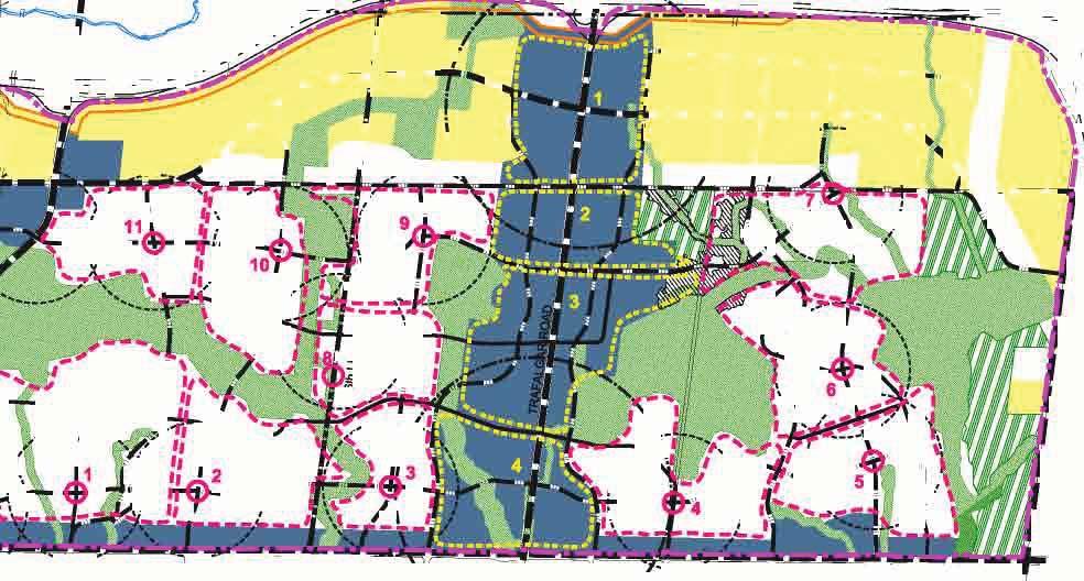
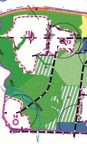
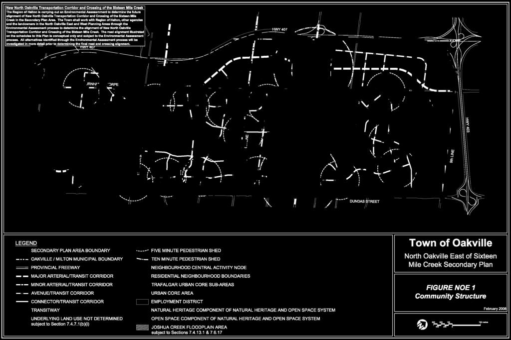
123
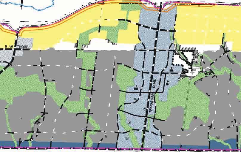
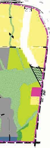
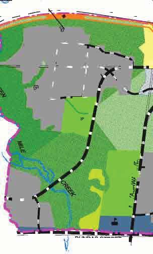
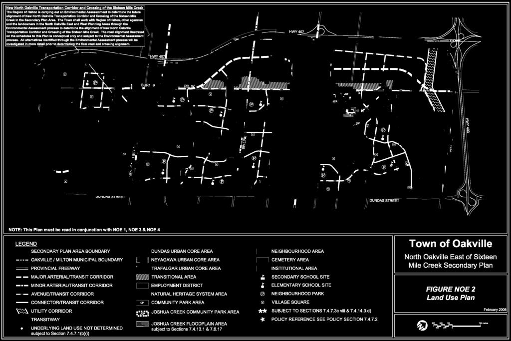
124
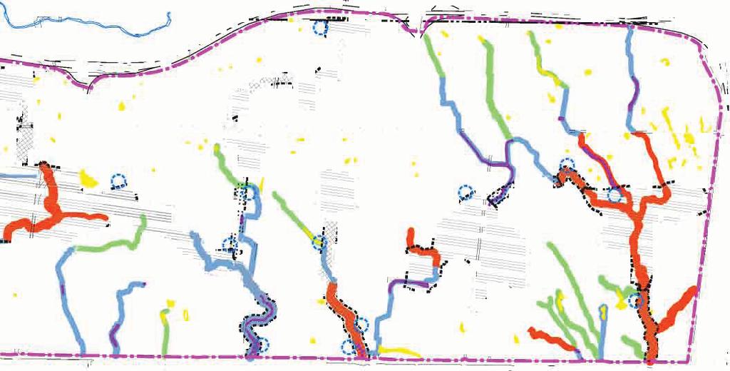
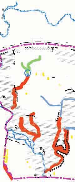
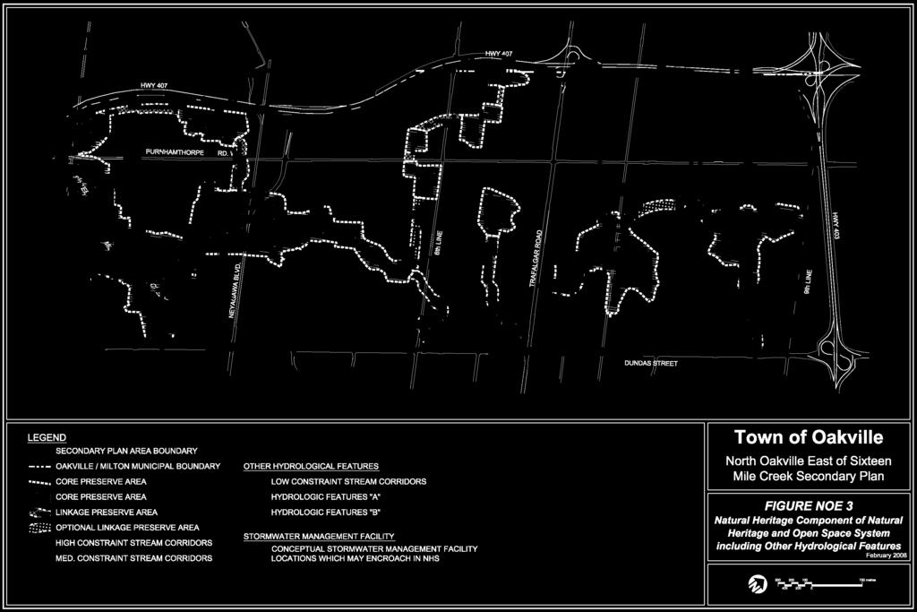
125
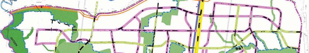
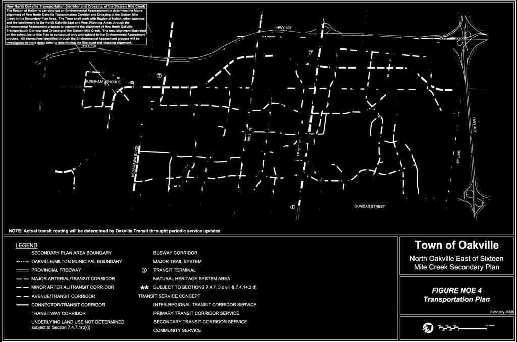
126
127 APPENDIX 7.1 DESIGNATED CULTURAL HERITAGE RESOURCES
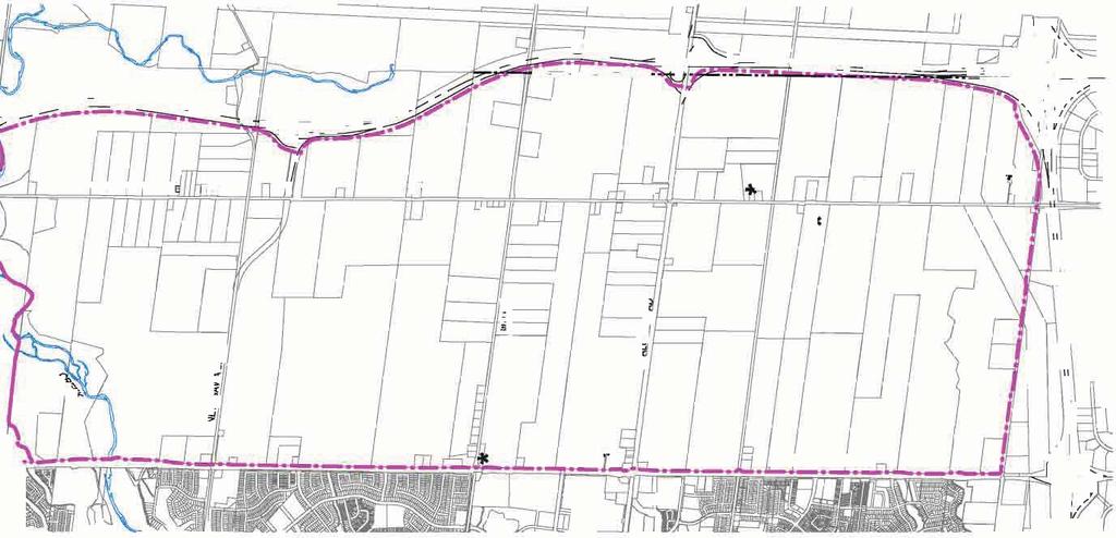
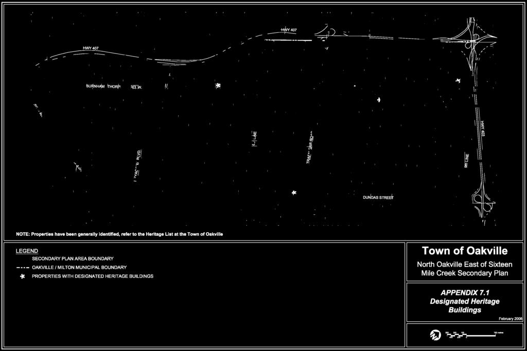
128
129 APPENDIX 7.2 SUBCATCHMENT AREAS
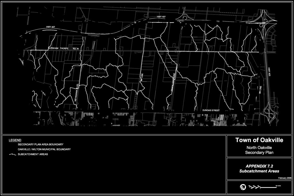
130
131 APPENDIX 7.3 MASTER PLAN
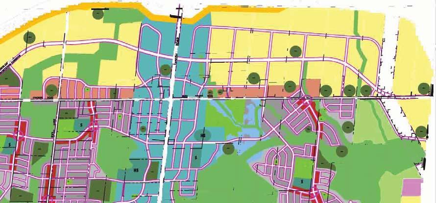
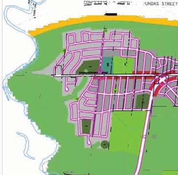
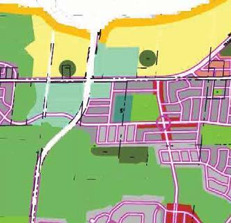
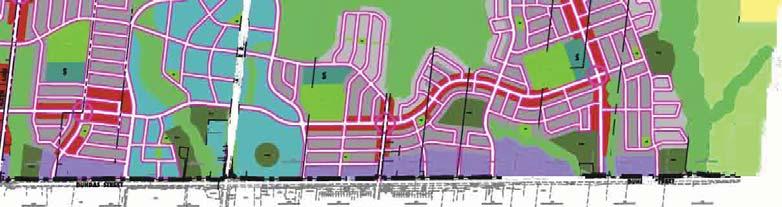
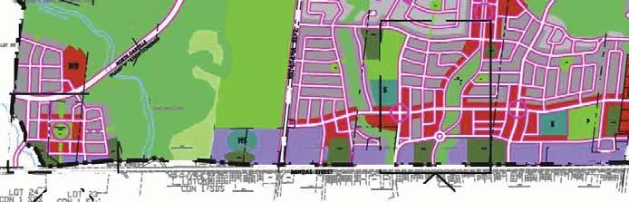
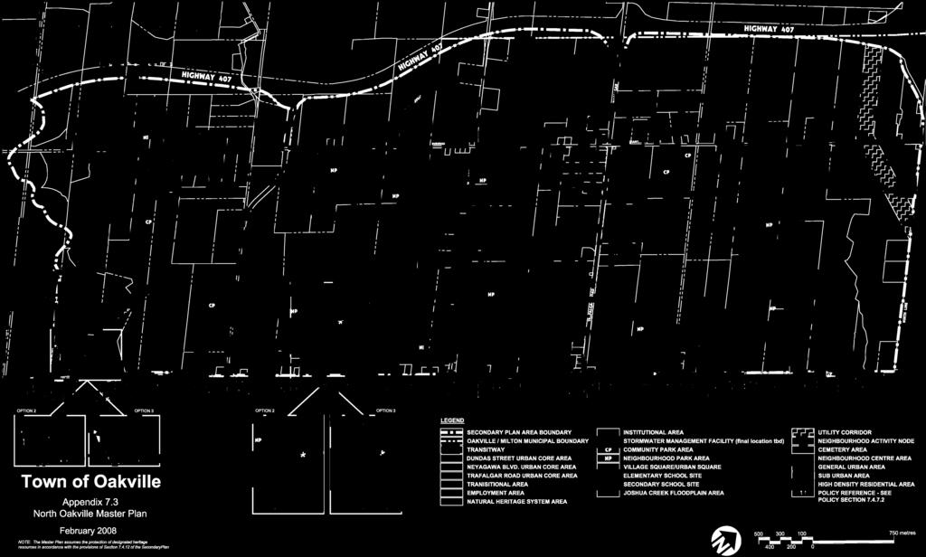
132
133 APPENDIX 7.4 STREAM CORRIDOR COMPONENTS


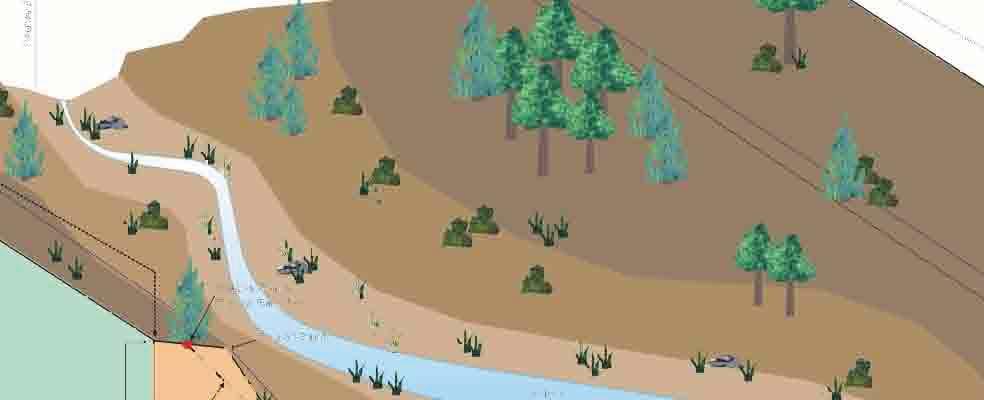
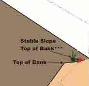
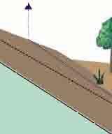


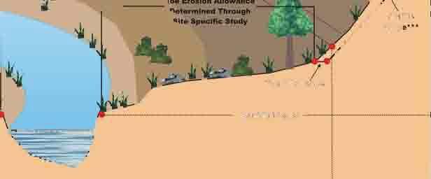
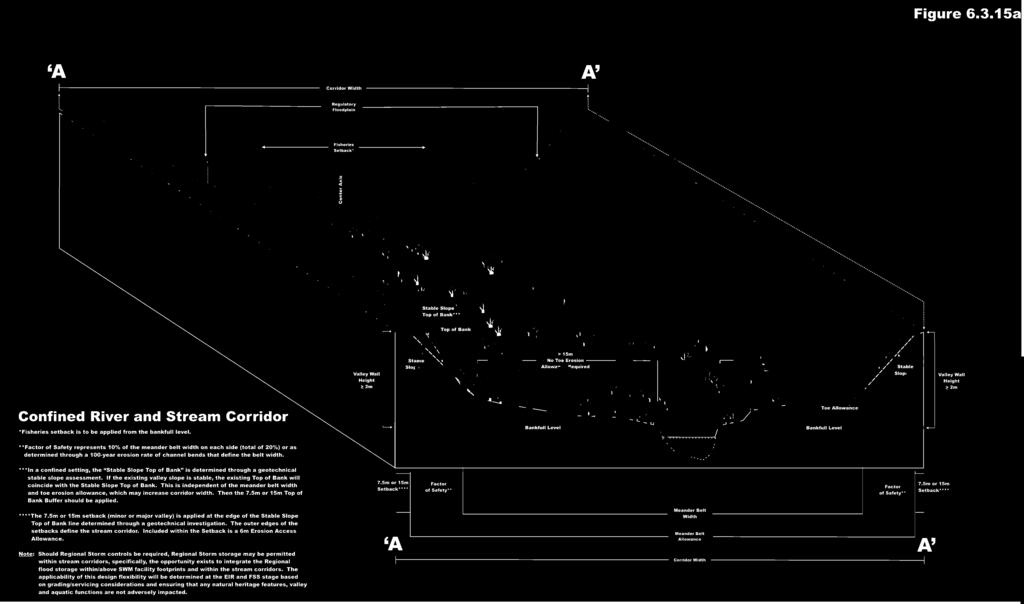
134


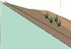


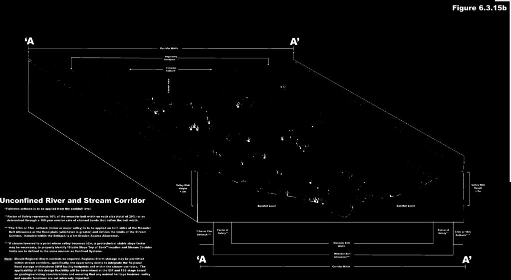
135
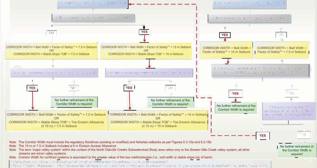

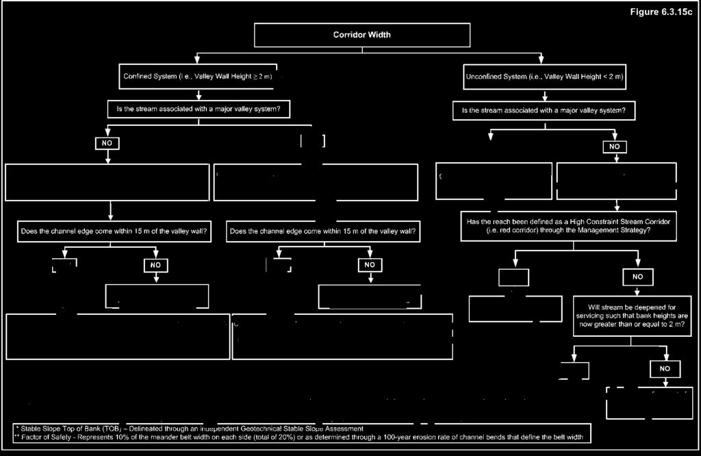
136
THE CORPORATION OF THE TOWN OF OAKVILLE BY-LAW NUMBER
 THE CORPORATION OF THE TOWN OF OAKVILLE BY-LAW NUMBER 20012-08530 A by-law to adopt an amendment to the Official Plan of the Oakville Planning Area (Official Plan Amendment 198) Land North of Dundas Street.
Bressa Developments Limited. Planning Justification Report. Revised Draft Plan of Subdivision and Zoning By-Law Amendment
 Bressa Developments Limited Revised Draft Plan of Subdivision and Zoning By-Law Amendment Planning Justification Report Part of Lots 7 & 8 Concession 1, North of Dundas Street Town of Oakville September,
AMENDMENT NO. 30 TO THE OFFICIAL PLAN OF THE TOWN OF MILTON
 AMENDMENT NO. 30 TO THE OFFICIAL PLAN OF THE TOWN OF MILTON Subject: Boyne Survey Secondary Plan and Related Official Plan Amendments The following text and schedules constitute Amendment No. 30 to the
North Oakville East Parks Facilities Distribution Plan. November, 2009
 North Oakville East November, 2009 POLICY CONTEXT 1) Purpose a) The purpose of this document is to be a guide for the location, configuration, design and development of the parks system for the North Oakville
AMENDMENT NO. 38 TO THE CITY OF BARRIE OFFICIAL PLAN SALEM SECONDARY PLAN. June 2014
 AMENDMENT NO. 38 TO THE CITY OF BARRIE OFFICIAL PLAN SALEM SECONDARY PLAN June 2014 AMENDMENT NO. 38 TO THE OFFICIAL PLAN OF THE BARRIE PLANNING AREA TABLE OF CONTENTS Page Introduction 1 Part A - The
COMMUNITY, DISTRICT AND SPECIAL STUDY AREA PLANS
 1.8 RIVER OAKS COMMUNITY - FIGURE "O" a) Background The River Oaks Community is bounded by Dundas Street on the north; the Sixteen Mile Creek on the west; Upper Middle Road on the south; and Trafalgar
The lands identified as Residential Areas on Schedule A1, Urban Structure, represent the areas that provide for stable residential communities.
 Livable Oakville Part D: Land Use Designations and Policies 11. RESIDENTIAL 11.1 General The lands identified as Residential Areas on Schedule A1, Urban Structure, represent the areas that provide for
Trafalgar Road Corridor Planning Study Open House
 Trafalgar Road Corridor Planning Study Open House June 24, 2013 6:30-8:30 p.m. Oakville & Trafalgar Rooms Overview The Livable Oakville Plan identifies the lands along Trafalgar Road, between the QEW and
AMENDMENT NO. TO THE CITY OF BARRIE OFFICIAL PLAN HEWITT S SECONDARY PLAN
 AMENDMENT NO. TO THE CITY OF BARRIE OFFICIAL PLAN HEWITT S SECONDARY PLAN OFFICIAL PLAN FOR THE CITY OF BARRIE Amendment No. Amendment No. to the was prepared by the Barrie General Committee and was recommended
PORT WHITBY COMMUNITY
 PORT WHITBY COMMUNITY SECONDARY PLAN UPDATE COMMUNITY IMPROVEMENT PLAN URBAN DESIGN GUIDELINES September 2015 DRAFT PROPOSED AMENDMENT NUMBER # to the Whitby Official Plan PURPOSE: The intent of this Amendment
11.4 Highway 400 North Employment Lands Secondary Plan APPROVED BY THE ONTARIO MUNICIPAL BOARD ON NOVEMBER 21, 2011
 11.4 Highway 400 North Employment Lands Secondary Plan APPROVED BY THE ONTARIO MUNICIPAL BOARD ON NOVEMBER 21, 2011 11.4.1 General 11.4.1.1. as approved by the Ontario Municipal Board on November 21, 2011,
Mark-up of the effect of the proposed Bronte Village Growth Area OPA No.18 on the text of section 24, Bronte Village, of the Livable Oakville Plan
 Mark-up of the effect of the proposed Bronte Village Growth Area OPA No.18 on the text of section 24, Bronte Village, of the Livable Oakville Plan Notes: This document is provided for information purposes
Tremaine Dundas Secondary Plan (Draft May 2017)
") PB-52-17 Appendix A Tremaine Dundas Secondary Plan (Draft May 2017) Page 2 Tremaine Dundas Secondary Plan (Draft May 2017) This page has been left blank intentionally Page 3 Tremaine Dundas Secondary Plan
PB-52-17 Appendix A Tremaine Dundas Secondary Plan (Draft May 2017) Page 2 Tremaine Dundas Secondary Plan (Draft May 2017) This page has been left blank intentionally Page 3 Tremaine Dundas Secondary Plan
URBAN DESIGN BRIEF. 2136&2148 Trafalgar Road. Town of Oakville
 URBAN DESIGN BRIEF 2136&2148 Trafalgar Road Town of Oakville Prepared By: METROPOLITAN CONSULTING INC For 2500674 Ontario Inc November 2016 TABLE OF CONTENTS Page No. 1.0 Introduction/Description of Subject
and services The protection and conservation of environmentally significant and sensitive natural heritage features and functions.
 6. Land Use 6.0 Preamble A healthy and livable city is one in which people can enjoy a vibrant economy and a sustainable healthy environment in safe, caring and diverse neighbourhoods. In order to ensure
CONTENTS 8.0 LAND USE 8.1 GENERAL LAND USE 8.2 RESIDENTIAL 8.3 MIXED USE 8.4 COMMERCIAL 8.5 EMPLOYMENT LANDS
 8-2 Land Use 8.0 LAND USE CONTENTS 8.1 GENERAL LAND USE 8.1.1 Uses provided for in all Land Use Designations 8.1.2 Uses prohibited in Hazardous Lands, Hazardous Sites and Special Policy Areas 8.1.3 Uses
FORMER CANADIAN FORCES BASE (CFB) ROCKCLIFFE SECONDARY PLAN. Official Plan Amendment XX to the Official Plan for the City of Ottawa
 ROCKCLIFFE SECONDARY PLAN. Official Plan Amendment XX to the Official Plan for the City of Ottawa") FORMER CANADIAN FORCES BASE (CFB) ROCKCLIFFE SECONDARY PLAN Official Plan Amendment XX to the Official Plan for the City of Ottawa 1 INDEX THE STATEMENT OF COMPONENTS PART A THE PREAMBLE PAGE Purpose...
FORMER CANADIAN FORCES BASE (CFB) ROCKCLIFFE SECONDARY PLAN Official Plan Amendment XX to the Official Plan for the City of Ottawa 1 INDEX THE STATEMENT OF COMPONENTS PART A THE PREAMBLE PAGE Purpose...
The West Vaughan Employment Area Secondary Plan Policies
 Part 2: The West Vaughan Employment Area Secondary Plan Policies 2.1 General Policies It is the policy of Council: 2.1.1. That the West Vaughan Employment Area (the WVEA), identified on Schedule 1, will
THE CORPORATION OF THE TOWN OF OAKVILLE BY-LAW NUMBER
 THE CORPORATION OF THE TOWN OF OAKVILLE BY-LAW NUMBER 2017-120 A by-law to adopt an amendment to the Livable Oakville Plan, Official Plan Amendment Number 20 (Downtown Oakville Growth Area) WHEREAS the
CONTENTS 2.0 A FRAMEWORK FOR SUSTAINABLE GROWTH 2.1 MANAGING SUSTAINABLE GROWTH THE VISION TO GOALS AND OBJECTIVES 2.3 MARKHAM STRUCTURE
 2 A Framework for Sustainable Growth 2.0 A FRAMEWORK FOR SUSTAINABLE GROWTH CONTENTS 2.1 MANAGING SUSTAINABLE GROWTH THE VISION TO 2031 2.2 GOALS AND OBJECTIVES 2.2.1 Protecting the Natural Environment
Figure 1- Site Plan Concept
 Figure 1- Site Plan Concept Parking will be provided underground on three levels at rate of 1.0 space/ unit; this rate includes all visitors parking. MMM Group has prepared a parking assessment (April,
11.4 Highway 400 North Employment Lands Secondary Plan
 11.4 Highway 400 North Employment Lands Secondary Plan APPROVED BY THE ONTARIO MUNICIPAL BOARD ON NOVEMBER 21, 2011 11.4.1 General 11.4.1.1. The following policies and Schedules A - I form Official Plan
Summary of Changes for the Comprehensive Draft Proposed Official Plan Amendment
 Summary of Changes for the Comprehensive Draft Proposed Official Plan Amendment Note: Due to the broad scope of the Official Plan Review, this list is not exhaustive of the extent of changes in the comprehensive
OFFICE CONSOLIDATION SECONDARY PLAN AREA 48. CHAPTER 48(b) COUNTRYSIDE VILLAGES SECONDARY PLAN
 COUNTRYSIDE VILLAGES SECONDARY PLAN") OFFICE CONSOLIDATION SECONDARY PLAN AREA 48 CHAPTER 48(b) COUNTRYSIDE VILLAGES SECONDARY PLAN October 2016 TABLE OF CONTENTS (Part II, Chapter 48(b)) Purpose. 1.0 Location 2.0 Effect of this Chapter and
OFFICE CONSOLIDATION SECONDARY PLAN AREA 48 CHAPTER 48(b) COUNTRYSIDE VILLAGES SECONDARY PLAN October 2016 TABLE OF CONTENTS (Part II, Chapter 48(b)) Purpose. 1.0 Location 2.0 Effect of this Chapter and
Table 8-4: Road Classification Local Roads, second table, of Chapter 8 Create a Multi-Modal City, be amended by adding the following:
 1 Port Street East Official Plan Amendment APPENDIX 3 Amendments to Mississauga Official Plan Table 8-4: Road Classification Local Roads, second table, of Chapter 8 Create a Multi-Modal City, be amended
HURON COMMUNITY PLAN
 CITY OF KITCHENER DEPARTMENT OF DEVELOPMENT AND TECHNICAL SERVICES PD 94/7 HURON COMMUNITY PLAN Recommended by Planning and Economic Development Committee: October 31, 1994 Adopted by Kitchener City Council:
MILTON HEIGHTS COMMUNITY January 2006 Revised February 2015 Revised November 2015
 REVISED DRAFT MILTON HEIGHTS COMMUNITY January 2006 Revised February 2015 Revised November 2015 Urban Design Guidelines Milton Heights Landowners Group This page has been intentionally left blank. Contents
1.0 PLANNING MARKHAM S FUTURE CONTENTS
 1-1 Planning Markham s Future 1.0 PLANNING MARKHAM S FUTURE CONTENTS 1.1 THE PURPOSE OF THE OFFICIAL PLAN 1.2 THE MARKHAM CONTEXT 1.3 THE REGULATORY CONTEXT 1.3.1 Province of Ontario 1.3.2 York Region
2136 & 2148 Trafalgar Road Town of Oakville Region of Halton
 PLANNING JUSTIFICATION REPORT 2136 & 2148 Trafalgar Road Town of Oakville Region of Halton Zoning By-Law Amendment Application 2500674 Ontario Inc. November 2016 Table of Contents Page 1.0 Location/Summary
6 Growth Management Challenges and Opportunities
 6 Growth Management Challenges and Opportunities The Town has established a goal of attaining a 50% participation rate with respect to employment opportunities versus residential population. The Town s
2.0 A FRAMEWORK FOR SUSTAINABLE GROWTH CONTENTS
 2-2 A Framework for Sustainable Growth 2.0 A FRAMEWORK FOR SUSTAINABLE GROWTH CONTENTS 2.1 MANAGING SUSTAINABLE GROWTH THE VISION TO 2031 2.2 GOALS AND OBJECTIVES 2.2.1 Protecting the Natural Environment
The protection of the agricultural resources of the Province;
 PART II INTRODUCTION An Official Plan is a policy document, which is intended to serve as the basis for making land use decisions and managing change in any municipality in Ontario. According to the Planning
Complete Neighbourhood Guidelines Review Tool
 Complete Neighbourhood Guidelines Review Tool Prepared By: City of Regina Planning Department October 2014 Page 1 of 14 Community Development Review Checklist for Secondary Plans and Concept Plans The
CONTENTS 6.1 URBAN DESIGN
 6-2 Urban Design and Sustainable Development 6.0 URBAN DESIGN AND SUSTAINABLE DEVELOPMENT CONTENTS 6.1 URBAN DESIGN 6.1.1 General Policies 6.1.2 The Public Realm 6.1.3 Streets and Blocks 6.1.4 Streetscapes
Draft Urban Hamilton Official Plan. Amendment No. XX
 1 of 75 The following text, together with: Draft Appendix A Appendix B Volume 1, Schedule E-1 Urban Land Use Designations Appendix C Volume 1, Appendix A Parks Classification Map Appendix D Volume 1, Appendix
Background Summary Report
 Background Summary Report May 2014 Submitted by Macaulay Shiomi Howson Ltd. In association with AMEC MMM Group Brook McIlroy Inc. Hemson Consulting Ltd. Table of Contents 1. Introduction... 1 2. Why is
URBAN DESIGN BRIEF URBAN DESIGN BRIEF 721 FRANKLIN BLVD, CAMBRIDGE August 2018
 URBAN DESIGN BRIEF URBAN DESIGN BRIEF 721 FRANKLIN BLVD, CAMBRIDGE August 2018 DESIGN BRIEF CONTENTS PART A 1.0 INTRODUCTION 2.0 DESCRIPTION & ANALYSIS OF SITE CONTEXT 3.0 DESIGN CONSTRAINTS AND OPPORTUNITIES
I615. Westgate Precinct
 I615. Westgate Precinct I615.1. Precinct Description The Westgate Precinct is located approximately 18km west of the Auckland city centre. There are seven Sub-precincts in the Westgate Precinct: Sub-precinct
Table of Contents 1.0 Introduction
 Table of Contents 1.0 Introduction..1 2.0 Site Description and Surrounding Land Uses 1 3.0 Redevelopment Proposal..3 4.0 Provincial, Regional and Municipal Policy Context... 10 4.1 The Provincial Policy
OFFICIAL PLAN FOR THE TOWN OF NEW TECUMSETH
 OFFICIAL PLAN FOR THE TOWN OF NEW TECUMSETH Approved by Simcoe County- March 10, 2010 TABLE OF CONTENTS PAGE# 1.0 TITLE AND COMPONENTS... 5 2.0 INTRODUCTION... 6 2.1 Purpose... 6 2.2 Organization of the
Midtown Oakville will be a vibrant, transit-supportive, mixed use urban community and employment area.
 Livable Oakville Part E: Growth Areas, Special Policy Areas and Exceptions 20. MIDTOWN OAKVILLE 20.1 Goal The interchange of Trafalgar Road and the QEW and the Oakville GO Station are major entry points
[PLANNING RATIONALE] For Site Plan Control and Lifting of Holding Zone By-Law 101 Champagne Avenue. May 23, 2014
![[PLANNING RATIONALE] For Site Plan Control and Lifting of Holding Zone By-Law 101 Champagne Avenue. May 23, 2014](/thumbs/75/71599615.jpg "[PLANNING RATIONALE] For Site Plan Control and Lifting of Holding Zone By-Law 101 Champagne Avenue. May 23, 2014") [PLANNING RATIONALE] For Site Plan Control and Lifting of Holding Zone By-Law 101 Champagne Avenue May 23, 2014 Contents 1.0 Introduction... 2 2.0 Site Context... 2 2.1 Adjacent Uses... 2 Figure 1: Site
[PLANNING RATIONALE] For Site Plan Control and Lifting of Holding Zone By-Law 101 Champagne Avenue May 23, 2014 Contents 1.0 Introduction... 2 2.0 Site Context... 2 2.1 Adjacent Uses... 2 Figure 1: Site
2.0 A FRAMEWORK FOR SUSTAINABLE GROWTH CONTENTS
 2-2 A Framework for Sustainable Growth 2.0 A FRAMEWORK FOR SUSTAINABLE GROWTH CONTENTS 2.1 MANAGING SUSTAINABLE GROWTH THE VISION TO 2031 2.2 GOALS AND OBJECTIVES 2.2.1 Protecting the Natural Environment
Planning Justification Report. Milton Meadows Properties Ltd. Milton Meadows South IN SUPPORT OF ZONING BY-LAW AMENDMENT & DRAFT PLAN OF SUBDIVISION
 Planning Justification Report Milton Meadows Properties Ltd. Milton Meadows South IN SUPPORT OF ZONING BY-LAW AMENDMENT & DRAFT PLAN OF SUBDIVISION For Part of Lot 3, Concession 1 Town of Milton HUMPHRIES
Employment and Commercial Review Analysis of Policy Directions
 Employment and Commercial Review Analysis of Policy Directions Appendix A The following analysis is town staff s response to the policy directions provided by the consultants who prepared the Employment
SCHEDULE 'A' TO BY-LAW as Amended by AMENDMENT NO. 90 TO THE WHITBY OFFICIAL PLAN
 SCHEDULE 'A' TO BY-LAW 6413-10 as Amended by 6553-11 AMENDMENT NO. 90 TO THE WHITBY OFFICIAL PLAN SECTION A: GROWTH PLAN CONFORMITY PURPOSE: LOCATION: BASIS: The purpose of this Amendment is to: conform
Urban Design Brief. Watson Parkway North & Watson Road North Guelph, Ontario. Prepared by Coletara Development
 Urban Design Brief Watson Parkway North & Watson Road North Guelph, Ontario Prepared by Coletara Development December, 2013 Urban Design Brief, Coletara Development 1 Introduction This Urban Design Brief
Sustainable Growth. Sustainable Growth
 2 Sustainable Growth Sustainable Growth SUSTAINABLE GROWTH 2.1 COMMUNITY VISION... 2-5 2.2 THE CITY SYSTEM... 2-7 2.2.1 AREAS... 2-7 2.2.2 CITY-WIDE SYSTEMS... 2-8 2.2.3 PROVINCIAL PLAN BOUNDARIES AND
A Growing Community Rural Settlement Areas
 Town of Huntsville Official Plan Review - POLICY BACKGROUND PAPER A Growing Community Rural Settlement Areas BACKGROUND: In addition to the fully municipally-serviced Urban Settlement Area and the Hidden
13. VANDORF-PRESTON LAKE SECONDARY PLAN 13.1 INTRODUCTION
 13. VANDORF-PRESTON LAKE SECONDARY PLAN 13.1.1 Purpose 13.1 INTRODUCTION The Vandorf-Preston Lake Secondary Plan establishes the principles, objectives and general policies, as well as specific strategies
Urban Design Manual PLANNING AROUND RAPID TRANSIT STATIONS (PARTS) Introduction. Station Study Areas
 Introduction. Station Study Areas") 111111 PLANNING AROUND RAPID TRANSIT STATIONS (PARTS) Introduction The ION rapid transit system will link Waterloo, Kitchener and Cambridge through a central transit corridor (CTC). There are a number
111111 PLANNING AROUND RAPID TRANSIT STATIONS (PARTS) Introduction The ION rapid transit system will link Waterloo, Kitchener and Cambridge through a central transit corridor (CTC). There are a number
THE STRUCTURE OF THE PLAN...
 TABLE OF CONTENTS THE STRUCTURE OF THE PLAN... 1 A1 THE COMMUNITY VISION... 3 A2 GOALS AND OBJECTIVES... 3 A2.1 THE NATURAL ENVIRONMENT... 3 A2.1.1 Goal... 3 A2.1.2 Objectives... 3 A2.2 GROWTH AND SETTLEMENT...
CITY OF LANGLEY OFFICIAL COMMUNITY PLAN BYLAW, 2005, NO APPENDIX II - REGIONAL CONTEXT MAP
 CITY OF LANGLEY OFFICIAL COMMUNITY PLAN BYLAW, 2005, NO. 2600 APPENDIX II - REGIONAL CONTEXT MAP ± Legend Agricultural Mixed Employment Industrial Conservation & Recreation Regional City Centre Urban Containment
ELMVALE ACRES SHOPPING CENTRE MASTER PLAN
 ELMVALE ACRES SHOPPING CENTRE MASTER PLAN Contents 1.0 INTRODUCTION... 2 2.0 LOCATION... 2 3.0 EXISTING CONTEXT... 2 4.0 VISION & GUIDING PRINCIPLES... 2 5.0 LAND USE AND BUILT FORM... 4 5.1 St. Laurent
YONGE STEELES CORRIDOR SECONDARY PLAN. Young + Wright / IBI Group Architects Dillon Consulting Ltd. GHK International (Canada) Ltd.
 Ltd.") PART A: PREAMBLE 1.0 PURPOSE The purpose of this Secondary Plan is to provide a development framework for intensification of the Yonge/ Steeles corridor including the north side of Steeles Avenue West
PART A: PREAMBLE 1.0 PURPOSE The purpose of this Secondary Plan is to provide a development framework for intensification of the Yonge/ Steeles corridor including the north side of Steeles Avenue West
COMMUNITY SUSTAINABILITY AND ENVIRONMENTAL MASTER PLAN IMPLEMENTATION UPDATE
 Attachment 1 COMMUNITY SUSTAINABILITY AND ENVIRONMENTAL MASTER PLAN IMPLEMENTATION UPDATE Priorities and Key Initiatives Committee May 2013 Page E-1 How we grow Goal 2: To ensure sustainable development
C.10 Boyne Survey Secondary Plan
 C.10 Boyne Survey Secondary Plan SECONDARY PLAN July 2017 C.10 BOYNE SURVEY SECONDARY PLAN C.10.1 C.10.1.1 GENERAL PURPOSE The purpose of the Boyne Survey Secondary Plan is to establish a more detailed
1 Introduction. Chapter. In this chapter:
 Chapter 1 Introduction In this chapter: 1.1 A Snapshot of the Region 1.2 Towards a Sustainable Region 1.3 The Provincial Context 1.4 Purpose and Organization The Regional Municipality of York Official
Leonard s Beach Secondary Plan (Alcona North) Official Plan Amendment
 Official Plan Amendment") Leonard s Beach Secondary Plan (Alcona North) Official Plan Amendment Public Meeting Presentation August 14, 2013 Note: This document is for presentation purposes only. Please see Staff Report DSR-135-13
Leonard s Beach Secondary Plan (Alcona North) Official Plan Amendment Public Meeting Presentation August 14, 2013 Note: This document is for presentation purposes only. Please see Staff Report DSR-135-13
Master Environmental Servicing Plan & Secondary Plan
 East Side Lands Stage 2 1 Master Environmental Servicing Plan & Secondary Plan Public Information Centre #1 June 16, 2016 Welcome! Today s Agenda Please sign in at the front desk. 5:30 pm 6:30 pm: Open
ARTICLE 6: Special and Planned Development Districts
 ARTICLE 6: Special and Planned Development Districts 6-10 Traditional Neighborhood Development (TND) District 6-10.10 Purpose and Intent The Traditional Neighborhood Development (TND) District provides
Brampton. Secondary Plan. Review. Bram West. A New Direction in Planning & Public Consultation
 Brampton Bram West Secondary Plan Review A New Direction in Planning & Public Consultation Introduction The Bram West Secondary Plan Review offers an important opportunity for the community to define a
NOTE: PLEASE REFER TO CITY PLAN FOR ADDITIONAL CITY-WIDE POLICIES WHICH APPLY TO THIS DISTRICT.
 NOTE: THE POLICIES IN THIS DOCUMENT ARE SPECIFIC TO THE SHERIDAN RESIDENTIAL PLANNING DISTRICT OF, AND MUST BE READ IN CONJUNCTION WITH ALL THE POLICIES OF CITY PLAN PLEASE REFER TO FOR ADDITIONAL CITY-WIDE
Report to: Development Services Committee Report Date: September 11, 2017
 ~RKHAM Report to: Development Services Committee Report Date: September 11, 2017 SUBJECT: PREPARED BY: Conceptual Master Plan for the Future Urban Area - Community Structure Plan and Key Policy Direction
Further input invited as Colchester Growth Strategy nears final phase
 IUE 3 / NOVEMBER 2015 Further input invited as Colchester Growth trategy nears final phase trathcona County is seeking public feedback as it enters the final phase of work on a Growth Management trategy
*** DRAFT 2 FOR PUBLIC REVIEW ***
 6.7 The area is generally bounded by the Red Hill Valley Parkway to the west, Lake Avenue to the east, the Queen Elizabeth Way (QEW) to the north, and by the properties just south of Queenston Road to
13 THORNHILL YONGE STREET STUDY IMPLEMENTATION CITY OF VAUGHAN OPA 669 AND TOWN OF MARKHAM OPA 154
 13 THORNHILL YONGE STREET STUDY IMPLEMENTATION CITY OF VAUGHAN OPA 669 AND TOWN OF MARKHAM OPA 154 The Planning and Economic Development Committee recommends the adoption of the recommendations contained
THE GARDEN CITY PLAN. City of St. Catharines Official Plan. City of St. Catharines
 THE GARDEN CITY PLAN City of St. Catharines Official Plan City of St. Catharines August 2010 APPROVAL INFORMATION This Official Plan of the City of St. Catharines Planning Area, known as the Garden City
MAYFIELD WEST SECONDARY PLAN PHASE 2
 MAYFIELD WEST SECONDARY PLAN PHASE 2 Public Open House #3 February 25, 2010 Draft Preferred Land Use Scenario TOWN OF CALEDON PLANNING & DEVELOPMENT DEPARTMENT Open House Agenda TOWN OF CALEDON 1. Welcome
9 CITY OF VAUGHAN OFFICIAL PLAN AMENDMENT NO BOCA EAST INVESTMENTS LIMITED
 9 CITY OF VAUGHAN OFFICIAL PLAN AMENDMENT NO. 631 - BOCA EAST INVESTMENTS LIMITED The Planning and Economic Development Committee recommends the adoption of the recommendations contained in the following
BRAMPTON FLOWERTOWN SECONDARY PLAN Area 6
 BRAMPTON FLOWERTOWN SECONDARY PLAN Area 6 October 2018 EXPLANATORY NOTES Brampton Flowertown Secondary Plan Area 6 General i. Secondary plans form part of the Official Plan and are to be read in conjunction
OFFICE CONSOLIDATION CHAPTER 47 HIGHWAY 427 INDUSTRIAL SECONDARY PLAN
 OFFICE CONSOLIDATION CHAPTER 47 HIGHWAY 427 INDUSTRIAL SECONDARY PLAN NOTE: This Secondary Plan is partially in effect. Highlighted sections are under appeal. August 2017 1 EXPLANATORY NOTE Office Consolidation
OFFICE CONSOLIDATION SECONDARY PLAN AREA 22 THE BRAMALEA SOUTH INDUSTRIAL SECONDARY PLAN
 OFFICE CONSOLIDATION SECONDARY PLAN AREA 22 THE BRAMALEA SOUTH INDUSTRIAL SECONDARY PLAN November 2010 EXPLANATORY NOTES (Secondary Plan Area 22) General (pertaining to all secondary plan office consolidations)
6 PORT SYDNEY SETTLEMENT AREA
 Section 6 Port Sydney Page 61 6 PORT SYDNEY SETTLEMENT AREA 6.1 Basis and Principles Village of Port Sydney Waterfront Community Existing Services 6.1.1 Port Sydney is an historic settlement that has developed
DAVENPORT VILLAGE SECONDARY PLAN
 27 DAVENPORT VILLAGE SECONDARY PLAN 27. DAVENPORT VILLAGE SECONDARY PLAN 1. VISION FOR THE DAVENPORT VILLAGE SECONDARY PLAN Davenport Village, municipally known as 830, 940, 980 and 1100 Lansdowne Avenue,
The Corporation of the Town of Milton
 Report To: From: Council Barbara Koopmans, Commissioner, Planning and Development Date: May 7, 2018 Report No: Subject: Making it Possible Positioning the Town s Strategy for Growth and Economic Development
CONSULTING SERVICES FOR THE WHITEBELT VISIONING EXERCISE ADDENDUM TO THE GTA WEST LAND USE STUDY WORK PROGRAM
 CONSULTING SERVICES FOR THE WHITEBELT VISIONING EXERCISE ADDENDUM TO THE GTA WEST LAND USE STUDY 1. Introduction WORK PROGRAM The Town of Caledon is a large, local municipality located in the Greater Toronto
Derry Green Corporate Business Park
 Town of Milton Derry Green Corporate Business Park Urban Design Guidelines BMI/Pace - June 2010 Draft 3 Prepared by: Brook McIlroy Planning + Urban Design / Pace Architects Suite 300-51 Camden Street Toronto,
KING CITY COMMUNITY PLAN
 KING CITY COMMUNITY PLAN TOWNSHIP OF KING JANUARY 27, 2000 AMENDMENT NO. 54 to the OFFICIAL PLAN for the TOWNSHIP OF KING PLANNING AREA THE COMMUNITY PLAN TABLE OF CONTENTS PAGE PART 1 INTRODUCTION 1.1
DRAFT Northeast Quadrant of Kipling Avenue and Highway 7 DRAFT AUGUST 29, Goals Land Use. The goals of this Plan are to:
 AUGUST 29, 2017 12.15 Northeast Quadrant of Kipling Avenue and Highway 7 12.15.1 Goals 12.15.2 Land Use The goals of this Plan are to: 12.15.2.1 General Provisions: a) Ensure the development of a compact
Official Plan Review
 Official Plan Review Summary Report - The Built Environment August 2014 Part 1: Introduction Planning for a healthy, prosperous and sustainable community is an important goal for our municipality. From
Growth Area Reviews Preliminary Directions for Midtown Oakville, the Uptown Core and Palermo Village
 Growth Area Reviews Preliminary Directions for Midtown Oakville, the Uptown Core and Palermo Village Livable Oakville Council Subcommittee January 15, 2018 1 Introduction Why a study? January 2014 Signaled
PART III LAND USE POLICIES URBAN PLANNING AREA
 To be read with other parts of the Plan 1.0 INTRODUCTION *D9 This part of the Plan presents the principles, objectives and policies for the land use designations identified on the Settlement Pattern and
This page has been intentionally left blank.
 This page has been intentionally left blank. Chapter 3 3-2 3. Employment 3.A Niagara Economic Gateway 3.A.1 General The Niagara Economic Gateway comprises: a) The Gateway Economic Zone which includes all
2.5 Roads. Loading and service areas adjacent to Highway 401 should be screened through architectural walls and/or landscape buffer planting.
 N HIGHWAY OFF RAMP 2.5 Roads A legible road network with a clear hierarchy will help create a connected community, both within and surrounding the Milton Heights. The following section outlines the proposed
Report to: Development Services Committee Report Date: April 24, 2017
 SUBJECT: Cornell Rouge National Urban Park Gateway - Report on Design Charrette and Next Steps PREPARED BY: Lilli Duoba, MES, MCIP, RPP, Manager, Natural Heritage (ext. 7925) REVIEWED BY: Marg Wouters,
NEW REGIONAL OFFICIAL PLAN HIGH LEVEL PROCESS & FRAMEWORK
 NEW REGIONAL OFFICIAL PLAN HIGH LEVEL PROCESS & FRAMEWORK Why A New Official Plan Originally the role of Regionally Planning and content of Regional Official Plan (1970s) primarily focused on protecting
WITNESS STATEMENT Of. Ronald Blake. On behalf of the Intervenor The Corporation of the City of Markham
 Filed: 2013-06028 EB-2012-0451 Exhibit L.EGD.COM.2 Page 1 of 7 WITNESS STATEMENT Of Ronald Blake On behalf of the Intervenor The Corporation of the City of Markham In the matter of an application by Enbridge
CITY OF NIAGARA FALLS. By-law No
 CITY OF NIAGARA FALLS By-law No. 2018- A by-law to provide for the adoption of Amendment No. 128 to the City of Niagara Falls Official Plan (OPA #128). THE COUNCIL OF THE CORPORATION OF THE CITY OF NIAGARA
178 Carruthers Properties Inc.
 178 Carruthers Properties Inc. Planning Rationale for 178 Carruthers Avenue Site Plan Control Application June 2014 Table of Contents 1.0 Introduction 2.0 Overview of Subject Property 3.0 Current Zoning
THE CITY OF VAUGHAN BY-LAW BY-LAW NUMBER A By-law to adopt Amendment Number 1 to the Official Plan of the Vaughan Planning Area.
 THE CITY OF VAUGHAN BY-LAW BY-LAW NUMBER 015-2014 A By-law to adopt Amendment Number 1 to the Official Plan of the Vaughan Planning Area. NOW THEREFORE the Council of the Corporation of the City of Vaughan
Smart Growth Development Checklist
 2004 Smart Growth Development Checklist Smart Growth Development Checklist Corporation of the City of New Westminster Guide and manage growth in a manner which is consistent with the principles of sustainable
Official Plan Review: Draft Built Form Policies
 PG.30.1 REPORT FOR ACTION Official Plan Review: Draft Built Form Policies Date: May 15, 2018 To: Planning and Growth Management Committee From: Chief Planner and Executive Director, City Planning Division
AGINCOURT SECONDARY PLAN
 1 AGINCOURT SECONDARY PLAN 1. AGINCOURT SECONDARY PLAN The following policies and principles apply to the area herein referred to as Agincourt, as outlined on Map 1-1. 1. GENERAL POLICIES 1.1 This Secondary
Foster Creek West Clarington, Ontario PLANNING JUSTIFICATION REPORT
 Foster Creek West Clarington, Ontario PLANNING JUSTIFICATION REPORT Official Plan Amendment Zoning By-law Amendment Neighbourhood Design Plan Amendment Draft Plan of Subdivision File No. 112092 February
THE CITY OF WINNIPEG BY-LAW NO. 4/2013. A By-law of THE CITY OF WINNIPEG to adopt a Secondary Plan for the Waverley West Southwest Neighbourhood.
 THE CITY OF WINNIPEG BY-LAW NO. 4/2013 A By-law of THE CITY OF WINNIPEG to adopt a Secondary Plan for the Waverley West Southwest Neighbourhood. THE CITY OF WINNIPEG, in Council assembled, enacts as follows:
TERRESTRIAL NATURAL HERITAGE SYSTEM STRATEGY APPENDIX F: MODEL POLICIES FOR THE IMPLEMENTATION OF THE TARGET TERRESTRIAL NATURAL HERITAGE SYSTEM
 TERRESTRIAL NATURAL HERITAGE SYSTEM STRATEGY APPENDIX F: MODEL POLICIES FOR THE IMPLEMENTATION OF THE TARGET TERRESTRIAL NATURAL HERITAGE SYSTEM C H A P T E R 1 M O D E L P O L I C I E S F O R I M P L
TO: Mayor & Council DATE: April 12, The Planning and Development Department and the Engineering Department recommend that Council:
 CORPORATE REPORT NO: R080 COUNCIL DATE: April 12, 2010 REGULAR COUNCIL TO: Mayor & Council DATE: April 12, 2010 FROM: SUBJECT: General Manager, Planning and Development General Manager, Engineering Neighbourhood
New-Cast Mixed-use Development Proposal King Street West, Newcastle, Ontario
 URBAN DESIGN BRIEF New-Cast Mixed-use Development Proposal King Street West, Newcastle, Ontario TABLE OF CONTENTS: 1.0 Executive Summary 2.0 Creating Vibrant and Sustainable Urban Places: Excerpts from
QUEEN-RIVER SECONDARY PLAN
 34 QUEEN-RIVER SECONDARY PLAN 34. QUEEN RIVER SECONDARY PLAN 1. INTRODUCTION The Queen-River area is approximately 6.4 hectares and is located at the eastern edge of the Downtown as shown on Map 34-1.