Regency Developments. Urban Design Brief. Holyrood DC2 Rezoning
|
|
|
- Elizabeth Cross
- 6 years ago
- Views:
Transcription
1 Regency Developments Urban Design Brief Holyrood DC2 Rezoning Stantec Consulting Ltd
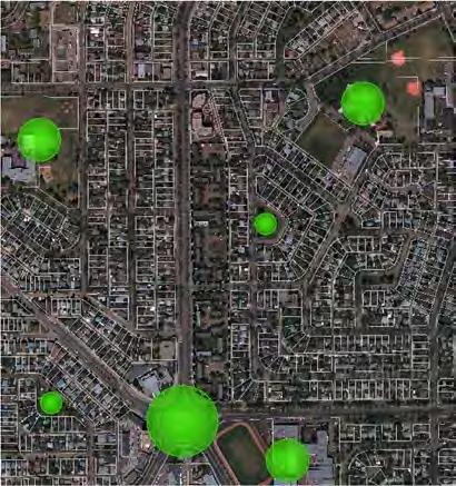
2 1. Overview Regency Developments intends to rezone the lands located at 8510 and Avenue, within the Holyrood neighbourhood. The site is bound by 85 Street to the west, 90 Avenue to the south, a rear lane to the east, and 95 Avenue to the north. The north portion of the site (Area 1) consists of two 5-storey apartment buildings which will not be redeveloped as part of this development. Regency s vision is to redevelop Area 2 (herein referred to as the site ) as mixed-use and high density in support of the planned Valley Line LRT construction. The site is envisioned to include a mix of low and high rise buildings, and their construction will be phased such that the low-rise woodframe buildings can be built to coincide with the construction of the LRT. The taller concrete buildings will be built over a longer timeframe. 2. Context Analysis Land Use and Character The site is located within the Holyrood neighbourhood, southeast of Edmonton s downtown. Other neighbourhoods within proximity to this site are Strathearn, Bonnie Doon, and Idylwylde. All these neighbourhoods were primarily developed during the 1950s as single or semi-detached 1-2 storey homes. As shown in Figure 2.1, the area is predominantly low density residential, with institutional, convenience commercial, and medium density residential uses interspersed throughout. The commercial hub of this area is the Bonnie Doon Mall which is located directly south of the site. There are also several civic/institutional parcels surrounding this site, including an Edmonton Public Library, 3 schools, and the University of Alberta s Campus Saint-Jean. Currently, the site consists of 2-storey apartment buildings with surface parking accessed via the rear lane. The site is adjacent to the planned Valley Line LRT Holyrood Stop at the intersection of 85 Street and 93 Avenue. The purpose of this urban design brief is two-fold. First, to provide an overview of the existing development and the surrounding area extending approximately m from the site (i.e. study area). Second, to provide the overarching design vision that will aid in the preparation and implementation of more detailed design plans in the next phases of development. 1 1 Information contained within this document is conceptual and subject to revisions and modifications. This document s purpose is to illustrate the intended design for the site. 1


3 Figure 2.1: Existing Land Uses Accessibility and Connectivity Figure 2.2 shows the street network in the vicinity of the site. These streets provide adequate vehicular access out of the community and throughout the city as follows: Connected to downtown via Connors Rd Access to Whyte Avenue via 83 Street or 85 Street Access east via 90 Avenue to industrial area and connections to 75 Street and 50 Street for access north Figure 2.2: Street Network and Accessibility The green lines on Figure 2.2 illustrate that sidewalks are the primary form of access within this area. The modified grid network of streets provides a reasonable degree of walkability, apart from some uncharacteristically-long blocks along the arterial roadways, including the north-south block that the subject site is part of. The large traffic circle to the south also restricts pedestrian access to the Bonnie Doon Shopping Centre. The existing on-street bike route on 79 Street connects to river valley trails, access to Downtown, and 76 Avenue east west bike route to University of Alberta. 2

4 The planned Valley Line LRT Holyrood stop will improve access to public transit, with convenient connection to Downtown s major employment centre. The associated upgrades to the surrounding roadways will also improve pedestrian connection across the reconfigured intersection at 85 Street and 90 Avenue. The Holyrood stop will be located at the intersection of 93 Avenue and 85 Street. Urban Pattern Figure 2.3 (figure-ground study) illustrates the modified grid built pattern of this area. The relationship between built areas and open space is typical of post-war suburban neighbourhoods that are largely single use, low density and interspersed with larger non-residential buildings. Figure 2.3: Figure-Ground Built Form Figure 2.4 (3d massing model) builds on the figure-ground study and illustrates the built form of the study area as predominantly 1-2 storeys. The model also illustrates a few taller buildings along the arterial roadway and within the neighbourhoods. A few sites have a slightly higher density with 2-4 storey apartments. Southwest of the traffic circle is a 16 storey apartment building accompanied by multiple 3 storey apartment buildings. 3

5 Location in the north portion of application (Area 1) is an existing 5 storey apartment development. landmark within the study area is the 16-storey apartment building, located adjacent to the most significant node i.e. the roundabout. Other church buildings and school buildings also serve as visual references for wayfinding. Figure 2.8: Nodes: There are several nodes of activity within the study area. The roundabout at the southwest corner of the site is the most significant node in the area, followed by school sites, institutional building sites, and pocket parks. *Edges: no significant edges were evident within the study area. Figure 2.4: 3D Massing Model Visual Quality and Legibility The following figures were prepared to understand the legibility of the study area based on the five elements identified by Kevin Lynch (1960) paths, districts, edges, landmarks, and nodes. Figure 2.5: Paths: major paths within the study area in of the site include 85 Street, 90 Avenue, 83 Street, and Connors Rd. Other smaller collector and local streets have also been identified as less prominent paths. Figure 2.6: Districts: the site is surrounded primarily by lowdensity residential districts. These districts are characterized by tree-lined interior streets and singlefamily houses interspersed with civic/institutional buildings and walk-up apartment buildings. Bonnie Doon Shopping Centre forms the other major district in the vicinity of the site. Figure 2.7: Landmarks: The study area has several major and minor landmark buildings. The most significant 4


6 Figure 2.5: Paths Figure 2.7: Landmarks Figure 2.6: Districts Figure 2.8: Nodes 5
7 3. Design Vision and Guiding Principles The vision for redevelopment of this Holyrood site focuses on creating a transit oriented development (TOD) that adds density, supports transit ridership, and integrates well with the existing neighbourhood and the planned Holyrood LRT stop. The design vision for the subject site will: Create a compact, walkable, and livable community; Establish a viable and thriving development that provides housing and shopping in a mixed use built form; Enhance the public realm and provide new amenities; and Pursue urban design excellence. The proposed redevelopment of the currently underutilized multi-family site provides an opportunity for large-scale TOD within an established neighbourhood that is often difficult to achieve. With this design brief in place, the intended vision and principles will guide future detailed plans. Establish a viable and thriving development that provides housing and shopping in a mixed use built form; Great urban places are created by the interaction between buildings and public spaces to form a high-quality environment and encourage community interaction. With opportunities for retail, offices, residences, and park spaces, activities throughout the day contribute to the overall atmosphere and liveliness promoting safety and comfort that people are drawn to. Pursue urban design excellence High quality design will enliven the public realm creating a sense place and belonging. Residents and neighbours will be proud of the space that they can use and enjoy throughout the seasons on their daily journey to/from the LRT stop. The site will be designed for comfort during the cold months by blocking the prevailing winds and allowing solar penetration. Design principles to prevent crime will be utilized to promote public safety and protection of private property. Create a compact, walkable and livable community Increased density around a transit station is a key principle to improving mobility, increasing ridership, and increasing foot traffic to commercial uses. The proposed development will also allow more families to live in the neighbourhood, who in turn will support the Holyrood school. Enhance the public realm and provide new amenities Local benefits of this site s rehabilitation are amplified by the community improvements planned for the site, including a connected pathway system and publicly accessible open spaces. The walkway system has been designed to increase the permeability of the large site. 6

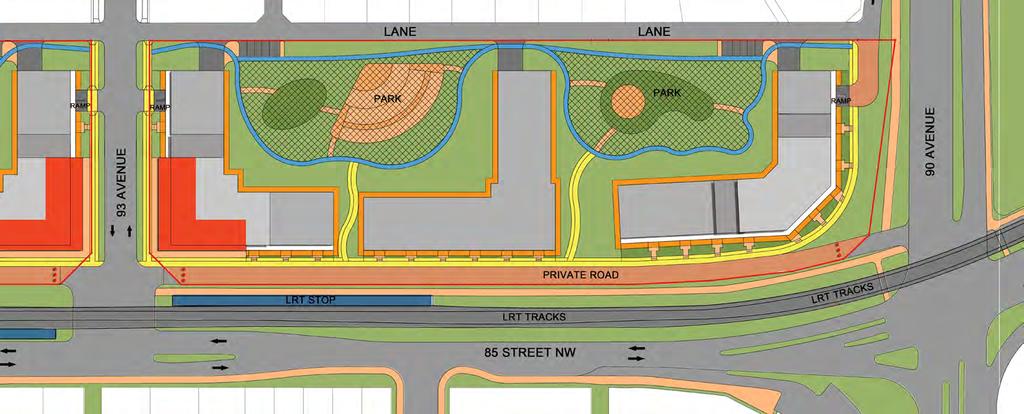
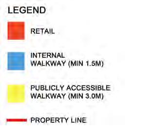
8 4. Design Intent Land Use and Built Form The overriding design intent is to break up the two long blocks, into four smaller development parcels, and create new pedestrian access through the site. This is achieved through provision of publicly-accessible pedestrian walkways, as well as internal walkways for residents. The proposed residential development will provide up to 1,200 dwelling units, within several mid to high-rise buildings. As shown in Figure 4.1, seven buildings are proposed in total. convenience opportunities that will draw patrons and help create a sense of place within the neighbourhood. A combination of primary walkways, which include a 1.8 m through zone as well as a 1.2 m furnishing zone, and internal walkways with a 1.5 m through zone will connect residents and pedestrians through and around the site. Parking is accommodated on-site via underground parkade, accessed from 93 Avenue as well as from the lane adjacent to 90 Avenue, with an additional exit to the north connecting to the rear lane. Four 6-storey residential buildings Two 18-storey mixed-use buildings at the intersection of 93 Avenue and 85 Street One 22-storey residential building The placement of each L-shaped building provides a clearly defined street wall along 85 Avenue. Ground floor units facing out of the site will be street-oriented with individual access at grade and defensible private amenity space. Ground floor units facing internally to the site will be ground-oriented, and feature individual access at grade and defensible private amenity space. The deliberate shape and orientation of the buildings creates four internal courtyards or outdoor amenity spaces that will be framed by the surrounding buildings. These outdoor amenity spaces shall be Publicly Accessible Private Parks to contribute to the community. At the intersection of 93 Avenue and 85 Street, adjacent to the LRT stop, two mixed use buildings will provide ground floor commercial/retail space. This commercial space is ideal for restaurants, coffee shops, and other neighbourhood-scale Figure 4.1 Site Building/Land Uses 7

9 Accessibility and Open Spaces A primary walkway is provided adjacent to the private road on the west edge of the site, to support pedestrian circulation around the site. Primary walkways on site provide a through connection in the north portion of the site and connect to each of the Publicly Accessible Private Parks. Primary walkways are a minimum 3.0 m in width, including a 1.8 m unobstructed sidewalk, as well as a furnishing zone to provide additional separation from vehicular circulation. Internal walkways allow circulation through the site and adjacent to the lane. Vehicular access to the site is maintained via 93 Avenue and a rear lane to the east of the site. Underground parkades will be accessed primarily from 93 Avenue, with an additional access/egress from the lane adjacent to 90 Avenue and additional egress to Area 1 with access to the rear lane Urban Pattern Figure 4.2 (figure-ground study) shows the L-shaped footprint of the proposed buildings in the context of the existing pattern. It also illustrates how the two larger blocks are further divided into four smaller blocks to increase permeability through the site. The buildings are deliberately aligned with the public roadways to frame them by creating a streetwall. The study also illustrates the way these buildings frame the interior open spaces to create well-defined outdoor spaces with a sense of enclosure. Figure 4.2 Figure-Ground Built Form and Transition Seven buildings are proposed on the site with various heights ranging from 6 to 22 storeys. The varied built form and the arrangement of buildings is utilized to provide an effective transition to the existing low-scale residential on the east side. This is achieve through generally limiting building heights on the east side to a maximum of 6 storeys with a minimum 10.0 m setback and minimizing building frontage along the east side. 8
10 Visual Quality and Legibility The previous figures illustrate the clear legibility of the site. Paths: the public walkways and internal walkways will create new paths through and around the site. Districts: because of the large size of the site, harmony in the overall design and built form, the site will have a character different than the surrounding areas. Accordingly, it can be characterized as a new mixed-use, high density district. Edges: The streetwall along 85 Street will create a new edge that will be perforated at regular intervals by paths. Landmarks: the two 18-storey buildings adjacent to the LRT stop will form a prominent landmark on 85 Street. The 22-storey building at the corner of 90 Avenue and 85 Street will serve as a prominent landmark close to the major intersection. Nodes: the proposed design will also add four activity nodes in the form of the open spaces on the site. Massing and View Angles Four of the buildings on site are 6-storeys in height, L-shaped to frame the private road and the on-site outdoor amenity spaces while minimizing the impacts on the adjacent low-density residential. Section A illustrates the view angles for the portions of these buildings that are oriented to the private road and 85 Street. Of the residential properties adjacent to the rear lane, approximately 77% will have this view angle. Section B illustrates the view angles for the portions of these buildings that extend to the rear lane. The view angle from the building footprint is provided to show the relative impact on the experience from the actual houses, accounting for the separation distance provided by the rear detached garages and rear yards. Three towers are provided; two 18-storey towers are located at the intersection of 93 Avenue and 85 Street and a 22-storey tower is located at 90 Avenue and 85 Street. The massing of these buildings is articulated through podiums and stepbacks as follows: 10.0 m Podium setback from east property line; 25.0 m Tower setback from east property line to minimize shadowing impact on the adjacent properties and the park areas; Provision of an 8 storey podium along 85 Street; Provision of a 6 storey podium east of the towers, to provide a transition to adjacent low density housing; Provision of minimum 2.0 m stepback above the second storey, to frame the pedestrian realm adjacent to the private road as well as 93 Avenue; Provision of 8.0 m Stepback from the east façades of all towers at the 14 th storey.; and Provision of 8.0 m Stepback at the 14 th storey of the north façade of the 22-storey tower. Section C provides the view angles for the portion of the podium that is oriented to the private road, with a height of 8 storeys. Section D illustrates the view angles for the 18-storey towers adjacent to 93 Avenue, illustrating the tower stepback and 6 storey podium transition to adjacent single detached dwellings. Section E provides the view angle for the 22-storey tower adjacent to 90 Avenue. 9


11 SECTIONS - VIEW ANGLES SECTION A A B A B KEY PLAN SECTION B


12 SECTIONS - VIEW ANGLES SECTION C C D C D KEY PLAN SECTION D

13 SECTIONS - VIEW ANGLES E E KEY PLAN SECTION E


14 Public Realm Design The following outlines the different design features that support the creation of a pedestrian-focused public realm (for more details, please refer to the accompanying DC2 zone). The buildings are aligned with and placed closer to the public roadways to frame and reinforce the public open space. All buildings abutting 85 Street and 93 Avenue will be designed to provide active street frontage, to increase safety and support pedestrian activity on the streets. All ground-floor units fronting public roadways will take direct access from the sidewalk. Section B (following page) illustrates the cross sections of the LRT corridor within 85 Street and Section G below provides a view of 93 Avenue and the relationship of the public realm with the built form on the site. The three taller buildings on the site will include a podium base (6 to 8 storeys) to mitigate wind impacts at the street level and a 2.0 metre stepback after the 2 nd storey to frame the streets/open spaces. Outdoor amenity areas will be well-designed such that they are integrated with the walkways on the site and interface actively with the adjacent buildings. These amenity areas will be designed as per City s Winter Design Guidelines to promote year-round use. The primary walkways will accommodate various streetscape elements such as street trees, shrubs, benches, pedestrian-scaled lighting, etc. Decorative and security lighting will provide a well-lit environment for pedestrians and provide security in publicly accessible areas. Section F illustrates the cross section of a primary walkway through the site. Signs on buildings will be well-designed and integrate with the architecture as per Schedule 59B of the Zoning Bylaw. Parking will be provided primarily within underground parkades to allow for pedestrian-oriented, recreational open spaces at grade. Garbage collection areas will be provided within the buildings, accessed via the rear lane. 13

15 Site Plan The following site plan figure illustrates the building footprint, pedestrian circulation, and Publicly Accessible Private Parks as mentioned in previous sections. 14


16 APPENDIX - IV PEDESTRIAN LINKAGES & AMENITY AREAS AREA 1 & AREA 2-A AREA 2-B
URBAN DESIGN BRIEF. 2136&2148 Trafalgar Road. Town of Oakville
 URBAN DESIGN BRIEF 2136&2148 Trafalgar Road Town of Oakville Prepared By: METROPOLITAN CONSULTING INC For 2500674 Ontario Inc November 2016 TABLE OF CONTENTS Page No. 1.0 Introduction/Description of Subject
ELMVALE ACRES SHOPPING CENTRE MASTER PLAN
 ELMVALE ACRES SHOPPING CENTRE MASTER PLAN Contents 1.0 INTRODUCTION... 2 2.0 LOCATION... 2 3.0 EXISTING CONTEXT... 2 4.0 VISION & GUIDING PRINCIPLES... 2 5.0 LAND USE AND BUILT FORM... 4 5.1 St. Laurent
Clairtrell Area Context Plan
 Clairtrell Area Context Plan March 2005 Urban Development Services City Planning Contents 1. Introduction... 4 2. Development Structure... 6 2.1 Streets... 7 2.1.1 Sheppard Avenue and Bayview Avenue...
WHAT WE HEARD REPORT - Summary Bonnie Doon Mall Redevelopment Application (LDA )
") WHAT WE HEARD REPORT - Summary Bonnie Doon Mall Redevelopment Application (LDA18-0184) PROJECT ADDRESS: 1 Bonnie Doon Shopping Centre NW, 8420 85 Street NW & 8715 85 Street NW PROJECT DESCRIPTION: Rezoning
WHAT WE HEARD REPORT - Summary Bonnie Doon Mall Redevelopment Application (LDA18-0184) PROJECT ADDRESS: 1 Bonnie Doon Shopping Centre NW, 8420 85 Street NW & 8715 85 Street NW PROJECT DESCRIPTION: Rezoning
URBAN DESIGN BRIEF URBAN DESIGN BRIEF 721 FRANKLIN BLVD, CAMBRIDGE August 2018
 URBAN DESIGN BRIEF URBAN DESIGN BRIEF 721 FRANKLIN BLVD, CAMBRIDGE August 2018 DESIGN BRIEF CONTENTS PART A 1.0 INTRODUCTION 2.0 DESCRIPTION & ANALYSIS OF SITE CONTEXT 3.0 DESIGN CONSTRAINTS AND OPPORTUNITIES
QUEEN-RIVER SECONDARY PLAN
 34 QUEEN-RIVER SECONDARY PLAN 34. QUEEN RIVER SECONDARY PLAN 1. INTRODUCTION The Queen-River area is approximately 6.4 hectares and is located at the eastern edge of the Downtown as shown on Map 34-1.
(DC1) Direct Development Control Provision DC1 Area 4
 Direct Development Control Provision DC1 Area 4") . General Purpose (DC) Direct Development Control Provision DC Area 4 The purpose of this Provision is to provide for an area of commercial office employment and residential development in support of the
. General Purpose (DC) Direct Development Control Provision DC Area 4 The purpose of this Provision is to provide for an area of commercial office employment and residential development in support of the
Complete Neighbourhood Guidelines Review Tool
 Complete Neighbourhood Guidelines Review Tool Prepared By: City of Regina Planning Department October 2014 Page 1 of 14 Community Development Review Checklist for Secondary Plans and Concept Plans The
Wide asphalt driveway abutting school property. garage built with incompatible materials, too close to park. incompatible fencing materials
 Wide asphalt driveway abutting school property incompatible fencing materials garage built with incompatible materials, too close to park Lack of plantings as a buffer between private property and open
CONTENTS 8.0 LAND USE 8.1 GENERAL LAND USE 8.2 RESIDENTIAL 8.3 MIXED USE 8.4 COMMERCIAL 8.5 EMPLOYMENT LANDS
 8-2 Land Use 8.0 LAND USE CONTENTS 8.1 GENERAL LAND USE 8.1.1 Uses provided for in all Land Use Designations 8.1.2 Uses prohibited in Hazardous Lands, Hazardous Sites and Special Policy Areas 8.1.3 Uses
East Bayshore Road Neighbourhood
 East Bayshore Road Neighbourhood Northridge Property Management Urban Design Brief 3195 East Bayshore Road City of Owen Sound January 2016 East Bayshore Road Neighbourhood Northridge Property Management
New-Cast Mixed-use Development Proposal King Street West, Newcastle, Ontario
 URBAN DESIGN BRIEF New-Cast Mixed-use Development Proposal King Street West, Newcastle, Ontario TABLE OF CONTENTS: 1.0 Executive Summary 2.0 Creating Vibrant and Sustainable Urban Places: Excerpts from
GUIDELINES. Transit Oriented Development. Approved by Edmonton City Council on February 15, 2012 in tandem with City Policy C565
 Transit Oriented Development GUIDELINES Prepared by the City of Edmonton Sustainable Development and Transportation Services Departments Approved by Edmonton City Council on February 15, 2012 in tandem
URBAN DESIGN BRIEF 181 Burloak Drive, Oakville
 URBAN DESIGN BRIEF 181 Burloak Drive, Oakville February 2017 Our File: 1730B 230-7050 WESTON ROAD / WOODBRIDGE / ONTARIO / L4L 8G7 / T: 905 761 5588/ F: 905 761 5589/WWW.MHBCPLAN.COM TABLE OF CONTENTS
178 Carruthers Properties Inc.
 178 Carruthers Properties Inc. Planning Rationale for 178 Carruthers Avenue Site Plan Control Application June 2014 Table of Contents 1.0 Introduction 2.0 Overview of Subject Property 3.0 Current Zoning
DRAFT Northeast Quadrant of Kipling Avenue and Highway 7 DRAFT AUGUST 29, Goals Land Use. The goals of this Plan are to:
 AUGUST 29, 2017 12.15 Northeast Quadrant of Kipling Avenue and Highway 7 12.15.1 Goals 12.15.2 Land Use The goals of this Plan are to: 12.15.2.1 General Provisions: a) Ensure the development of a compact
New Street Proposed Redevelopment Architecture & Urban Design Brief
 2130 2136 New Street Proposed Redevelopment Architecture & Urban Design Brief Prepared By: Cynthia Zahoruk Architect Inc. 3077 New Street, Burlington, ON, L7N 1M6 TABLE OF CONTENTS Background and Objective
Urban Design Brief Fanshawe Park Road. Competition Toyota
 Urban Design Brief 1300 Fanshawe Park Road Competition Toyota May 2, 2014 TABLE OF CONTENTS Page No. INTRODUCTION... 1 SECTION 1 LAND USE PLANNING CONTEXT... 1 1.1 The Subject Lands... 1 1.2 The Proposal...
*** DRAFT 2 FOR PUBLIC REVIEW ***
 6.7 The area is generally bounded by the Red Hill Valley Parkway to the west, Lake Avenue to the east, the Queen Elizabeth Way (QEW) to the north, and by the properties just south of Queenston Road to
Lehigh Acres Land Development Regulations Community Planning Project
 Lehigh Acres Land Development Regulations Planning Effort Summary In July, 2010 Commissioner Frank Mann invited the Lehigh Acres community to start discussing how to achieve their recently adopted community
Urban Design Brief December 23, 2015 Southside Construction Group Official Plan & Zoning By-Law Amendment
 Urban Design Brief Proposed Official Plan & Zoning By-Law Amendment 3244, 3263 and 3274 Wonderland Road South Southside Group December 23, 2015 TABLE OF CONTENTS Page No. INTRODUCTION... 1 SECTION 1 LAND
Highland Village Green Design Guidelines
 Highland Village Green Design Guidelines Publishing Information Title Highland Village Green Design Guidelins Author The City of Calgary Status DRAFT - Proposed document subject to changes Additional Copies
Yonge Eglinton Centre Urban Design Guidelines
 Yonge Eglinton Centre Urban Design Guidelines City Planning Urban Design January 2009 YONGE EGLINTON CENTRE INTRODUCTION.................................................... 1 GENERAL SITE PLAN OBJECTIVES......................................
Bank Street Secondary Plan
 1.1 Introduction The is a guide to the long term design and development of the portion of Bank Street between Riverside Drive and Ledbury Park, and provides direction on land use, built form, design, parking,
WEST LOOP DESIGN GUIDELINES CHECKLIST
 WEST LOOP DESIGN GUIDELINES CHECKLIST Section 1.0 General Strategies 1.1 DESIGN EXCELLENCE: ENCOURAGE HIGH QUALITY AND INNOVATIVE DESIGN OF NEW BUILDINGS WITHIN THE WEST LOOP WITHOUT BEING PRESCRIPTIVE
appendix and street interface guidelines
 appendix five: building and street interface guidelines appendix 5 building and street interface guidelines BOULEVARDS Boulevards are generally characterized by higher levels of traffic movement at higher
Urban Design Brief. Watson Parkway North & Watson Road North Guelph, Ontario. Prepared by Coletara Development
 Urban Design Brief Watson Parkway North & Watson Road North Guelph, Ontario Prepared by Coletara Development December, 2013 Urban Design Brief, Coletara Development 1 Introduction This Urban Design Brief
Table of Contents. Elm Avenue Improvement Plan City of Waco, Texas. Introduction 1. Existing Context 1 Figure 1 2.
 Table of Contents Introduction 1 Existing Context 1 Figure 1 2 Plan Guidelines 3 Future Urban Form 4 The West-End 4 Main Street 6 The East-End 7 Figure 2 9 Public Improvement Recommendations 7 General
5.1 Site Plan Guidelines
 5. Community Core Guidelines Development of the Community Core will take place by plan of subdivision and site plan approval. It will occur in a phased manner that will reflect the timing of residential
Urban Design Brief to 1557 Gordon Street & 34 Lowes Road West
 Urban Design Brief 1533 to 1557 Gordon Street & 34 Lowes Road West Reid s Heritage Homes Ltd. & 883928 Ontario Ltd. and RHH Property Management Ltd. City of Guelph Zoning By-law Amendment November 2017
Cit of Kitchener Ur 6 an Design Manual PARTA. Desi n for _--::
 Cit of Kitchener Ur 6 an Design Manual Date PARTA Year ) Desi n for k Nodes Corridors _--:: Section Page 01 of 12 2 INTRODUCTION Purpose & Application Nodes and Corridors have been identified as key intensification
Corridor Transformation Strategy
 Corridor Transformation Strategy County Road 22 Special Planning Area Design Guidelines January 2012 D14-06017 Corridor Transformation Strategy County Road 22 Special Planning Area Corridor Design Guidelines
URBAN DESIGN BRIEF 305, 309, & 315 SOUTHDALE ROAD WEST LONDON ONTARIO
 URBAN DESIGN BRIEF 305, 309, & 315 SOUTHDALE ROAD WEST LONDON ONTARIO CARVEST PROPERTIES LTD. December 2013 Section 1 - Land Use Planning Context 1.1 Subject Lands The subject lands are located immediately
3.0 URBAN DESIGN. December 6, OVERVIEW
 Urban Design 3.0 URBAN DESIGN December 6, 2007 3.1 OVERVIEW The highly urban character of Easton Place is defined by the overall design of the community. The following sections provide an overview of the
Uptown Rideau Street Secondary Plan [Amendment #166, January 12, 2016]
![Uptown Rideau Street Secondary Plan [Amendment #166, January 12, 2016]](/thumbs/76/73760497.jpg "Uptown Rideau Street Secondary Plan [Amendment #166, January 12, 2016]") [Amendment #166, January 12, 2016] The policies of this Secondary Plan are in effect, save and except for the property at 560 Rideau Street, for which there remains a site specific appeal to this Secondary
[Amendment #166, January 12, 2016] The policies of this Secondary Plan are in effect, save and except for the property at 560 Rideau Street, for which there remains a site specific appeal to this Secondary
Agenda. 7 Wright Crescent Urban Design Study. Public Meeting and Urban Design Workshop. 1 INTRODUCTION AND BACKGROUND (City of Kingston)
") Urban Design Study Public Meeting and Urban Design Workshop October 02, 2013 Agenda 1 INTRODUCTION AND BACKGROUND (City of Kingston) 2 URBAN DESIGN STUDY PRESENTATION (Antonio Gomez-Palacio, DIALOG) 3
Urban Design Study Public Meeting and Urban Design Workshop October 02, 2013 Agenda 1 INTRODUCTION AND BACKGROUND (City of Kingston) 2 URBAN DESIGN STUDY PRESENTATION (Antonio Gomez-Palacio, DIALOG) 3
Figure 3-1: Public Realm Plan
 3 Public Realm Figure 3-1: Public Realm Plan 3.1 Public Realm Concept The public realm concept for the Little Mountain site integrates a clear and accessible movement network with public spaces for social
Bel-Air Lexus Automobile Service Station
 Bel-Air Lexus Automobile Service Station Design Brief 443-447 McArthur Avenue Ottawa April 30, 2015 14-1299-MCA Site Details Application: Site Plan Control Legal Description and Municipal Addresses: 443
URBAN DESIGN BRIEF REPORT
 URBAN DESIGN BRIEF REPORT PREPARED FOR 2568401 ONTARIO INC NEW GASBAR, CONVENIENCE STORE & CARWASH DEVELOPMENT @ 1509 FANSHAWE PARK ROAD WEST LONDON, ONTARIO GAMA ENGINEERING INC. PROJECT NUMBER 1669 PREPARED
[PLANNING RATIONALE] For Site Plan Control and Lifting of Holding Zone By-Law 101 Champagne Avenue. May 23, 2014
![[PLANNING RATIONALE] For Site Plan Control and Lifting of Holding Zone By-Law 101 Champagne Avenue. May 23, 2014](/thumbs/75/71599615.jpg "[PLANNING RATIONALE] For Site Plan Control and Lifting of Holding Zone By-Law 101 Champagne Avenue. May 23, 2014") [PLANNING RATIONALE] For Site Plan Control and Lifting of Holding Zone By-Law 101 Champagne Avenue May 23, 2014 Contents 1.0 Introduction... 2 2.0 Site Context... 2 2.1 Adjacent Uses... 2 Figure 1: Site
[PLANNING RATIONALE] For Site Plan Control and Lifting of Holding Zone By-Law 101 Champagne Avenue May 23, 2014 Contents 1.0 Introduction... 2 2.0 Site Context... 2 2.1 Adjacent Uses... 2 Figure 1: Site
FLORIN ROAD CORRIDOR Site Plan and Design Review Guidelines Checklist
 FLORIN ROAD CORRIDOR Site Plan and Design Review Guidelines Checklist Applicant s Name: Project Address: Phone: Email: Applicant shall fill out the design guidelines checklist for all guidelines applicable
Urban Design Brief 1576 Richmond Street City of London
 Urban Design Brief City of London Treadstone Developments October 31, 2014 Urban Design Brief October 31, 2014 TABLE OF CONTENTS Page No. INTRODUCTION... 1 SECTION 1 LAND USE PLANNING CONCEPT... 1 1.1
Mixed Use Centres Development Permit Guidelines
 1 Mixed Use Centres Development Permit Guidelines Area Commercial or Mixed Use development occurring in City Centre, Urban Centre, Neighbourhood Centre, or Institutional Complex land use designations is
Westwind Developments Ltd. PIONEER LANDS AREA STRUCTURE PLAN - PROPOSED AMENDMENT
 FEBRUARY 2013 TABLE OF CONTENTS 1.0 BACKGROUND... 1 1.1 Amendment... 1 2.0 LOCATION & CONTEXT... 2 2.1 Land Ownership... 2 3.0 POLICY CONTEXT... 3 3.1 Municipal Development Plan... 3 3.2 Capital Region
WINDSOR GLEN DESIGN GUIDELINES
 WINDSOR GLEN DESIGN GUIDELINES Adopted by Council, 2006 WINDSOR GLEN REDEVELOPMENT DESIGN GUIDELINES August 2006 1.0 Master Plan Organization For this area of the Coquitlam Town Centre, a mix of high,
Urban Design Brief Proposed Residential Development 5219 Upper Middle Road City of Burlington
 Urban Design Brief Proposed Residential Development 5219 Upper Middle Road City of Burlington Prepared by Weston Consulting Prepared for BLOOMFIELD DEVELOPMENT INC. Date: March 2017 Table of Contents 1.
Revitalization Guidelines for Corridors, Villages and Town Centres
 Revitalization Guidelines for Corridors, Villages and Town Centres July 2017 Updated May, 2018 Publishing Information Title: Prepared by: Revitalization Guidelines for Corridors, Villages and Town Centres
HIGHLAND VILLAGE GREEN URBAN DESIGN PRINCIPLES/GUIDELINES
 URBAN DESIGN GUIDING PRINCIPLES/GUIDELINES CONTEXT/CHARACTER The City of Calgary s Municipal Development Plan (MDP), Transit-Oriented Development (TOD) Policy Guidelines and Main Street/Corridor policy
Mark-up of the effect of the proposed Bronte Village Growth Area OPA No.18 on the text of section 24, Bronte Village, of the Livable Oakville Plan
 Mark-up of the effect of the proposed Bronte Village Growth Area OPA No.18 on the text of section 24, Bronte Village, of the Livable Oakville Plan Notes: This document is provided for information purposes
Urban Design Manual PLANNING AROUND RAPID TRANSIT STATIONS (PARTS) Introduction. Station Study Areas
 Introduction. Station Study Areas") 111111 PLANNING AROUND RAPID TRANSIT STATIONS (PARTS) Introduction The ION rapid transit system will link Waterloo, Kitchener and Cambridge through a central transit corridor (CTC). There are a number
111111 PLANNING AROUND RAPID TRANSIT STATIONS (PARTS) Introduction The ION rapid transit system will link Waterloo, Kitchener and Cambridge through a central transit corridor (CTC). There are a number
Urban Design Brief. 583, 585 and 589 OXFORD STREET EAST. Salt Clinic Canada Inc.
 Urban Design Brief 583, 585 and 589 OXFORD STREET EAST Salt Clinic Canada Inc. February 3, 2013 TABLE OF CONTENTS Page No. INTRODUCTION... 1 SECTION 1 LAND USE PLANNING CONCEPT... 1 1.1 The Subject Property...
9955 JASPER DC2 URBAN DESIGN BRIEF. Prepared by: Stantec Consulting Ltd. August 2018
 9955 JASPER DC2 URBAN DESIGN BRIEF 1 Prepared by: Stantec Consulting Ltd. August 2018 TABLE OF CONTENTS OVERVIEW 3 PURPOSE 3 CONTEXT 3 DESIGN VISION 8 SUN SHADOW STUDY 10 PUBLIC REALM 12 RESPONSE TO CITY
Urban Design Guidelines Townhouse and Apartment Built Form
 Urban Design Guidelines Townhouse and Apartment Built Form Town of Wasaga Beach Table of Contents 1. Introduction 1.1. Purpose 1.2. Urban Design Principles 1.3. Application of Guidelines 2. Site Design,
Community Design Plan
 Gardena General Plan 2006 Authority While the is not a required element of a General Plan, it is included because improving the community appearance and image is paramount to the overall quality of life
DRAFT. October Wheaton. Design Guidelines
 October 2011 DRAFT Wheaton Design Guidelines 2 Draft - Design Guidelines - Wheaton Sector Plan Contents 04 Section 1: Introduction 06 Section 2: Context 08 Section 3: Design Guidelines 09 Goal 1: Create
POLICY AMENDMENT AND LAND USE AMENDMENT TUXEDO PARK (WARD 9) CENTRE STREET N AND 26 AVENUE NE BYLAWS 36P2017 AND 234D2017
 CENTRE STREET N AND 26 AVENUE NE BYLAWS 36P2017 AND 234D2017") Page 1 of 11 EXECUTIVE SUMMARY This application proposes to redesignate a single parcel of land in the Community of Tuxedo Park from Commercial Corridor 2 (C-COR2 f1h10) District to Mixed Use Active Frontage
Page 1 of 11 EXECUTIVE SUMMARY This application proposes to redesignate a single parcel of land in the Community of Tuxedo Park from Commercial Corridor 2 (C-COR2 f1h10) District to Mixed Use Active Frontage
URBAN DESIGN BRIEF Gordon Street City of Guelph. Prepared on behalf of Ontario Inc. March 25, Project No. 1507
 URBAN DESIGN BRIEF 1131 Gordon Street City of Guelph Prepared on behalf of 1876698 Ontario Inc. March 25, 2016 Project No. 1507 423 Woolwich Street, Suite 201, Guelph, Ontario, N1H 3X3 Phone (519) 836-7526
PORT WHITBY COMMUNITY
 PORT WHITBY COMMUNITY SECONDARY PLAN UPDATE COMMUNITY IMPROVEMENT PLAN URBAN DESIGN GUIDELINES September 2015 DRAFT PROPOSED AMENDMENT NUMBER # to the Whitby Official Plan PURPOSE: The intent of this Amendment
PUBLIC RIGHT-OF-WAY IN THIS CHAPTER PUBLIC REALM
 PUBLIC RIGHT-OF-WAY This section provides design guidelines for improvements in the public right-of-way. The public right-of-way refers to streets, sidewalks, non-vehicular thoroughfares, parks and greenways
burlington mobility hubs study Downtown Burlington Mobility Hub
 burlington mobility hubs study Downtown Burlington Mobility Hub Draft Precinct Plan Workbook PIC #3, September 7, 2017 downtown mobility hub objectives City staff and their consultants are proposing an
BESSARION-LESLIE CONTEXT PLAN
 Development in the Bessarion-Leslie area will be consistent with the following urban design guidelines. They provide a framework for development in the area and are to be read in conjunction with the urban
DRAFT. 1. General Purpose. 2. Area of Application. 3. Uses CLIFTON PLACE AREA A DC2 (DRAFT)
") CLIFTON PLACE AREA A DC2 () May 1, 2017 1. General Purpose To accommodate a high rise, high density residential Tower and podium that will accommodate a potential mix of commercial and residential uses,
CLIFTON PLACE AREA A DC2 () May 1, 2017 1. General Purpose To accommodate a high rise, high density residential Tower and podium that will accommodate a potential mix of commercial and residential uses,
BENSON / HUNT TERTIARY PLAN
 BENSON / HUNT TERTIARY PLAN TABLE OF CONTENTS 1.0 INTRODUCTION 1.1 Purpose 2 1.2 How to Read This Plan 3 1.3 Tertiary Plan Context 3 1.4 Vision and Principles 5 1.5 Public Consultation 5 2.0 PLANNING CONTEXT
DRAFT. 10% Common Open Space
 % OF CHARLOTTE IS CATEGORIZED AS A. LAND USES : Placeholder map displaying location of Place Type GOALS: Accommodate XX% of future growth. Provide a concentration of primarily commercial and civic activity
4.1.3 LAND USE CATEGORIES
 4.1.3 LAND USE CATEGORIES a. City Center District The City Center District incorporates the existing character and mix of uses in downtown Belmont to encourage redevelopment and new development in keeping
FORMER CANADIAN FORCES BASE (CFB) ROCKCLIFFE SECONDARY PLAN. Official Plan Amendment XX to the Official Plan for the City of Ottawa
 ROCKCLIFFE SECONDARY PLAN. Official Plan Amendment XX to the Official Plan for the City of Ottawa") FORMER CANADIAN FORCES BASE (CFB) ROCKCLIFFE SECONDARY PLAN Official Plan Amendment XX to the Official Plan for the City of Ottawa 1 INDEX THE STATEMENT OF COMPONENTS PART A THE PREAMBLE PAGE Purpose...
FORMER CANADIAN FORCES BASE (CFB) ROCKCLIFFE SECONDARY PLAN Official Plan Amendment XX to the Official Plan for the City of Ottawa 1 INDEX THE STATEMENT OF COMPONENTS PART A THE PREAMBLE PAGE Purpose...
The Master Plan Framework
 The Master Plan Framework The East Harbour Master Plan advances the development of 60 acres of former industrial lands east of the Don River. The Master Plan outlines a vision for a vibrant, transit-oriented
URBAN DESIGN STUDY and GUIDELINES
 ALTON CENTRAL EAST COMMUNITY CITY OF BURLINGTON URBAN DESIGN STUDY and GUIDELINES Prepared by NAK DESIGN GROUP March 2004 ALTON CENTRAL EAST CITY OF BURLINGTON TABLE OF CONTENTS PART I - Alton Central
A. Background Summary of Existing Challenges and Potential Possibilities. 1. Summary of Existing Assets and Potential Opportunities
 A. Background 1 A Main Street Master Plan Study was performed and completed in October of 2007. The study was initiated to review current land uses and development patterns along Main Street, from Parrish
1. General Purpose. 3. Uses
 1. General Purpose The purpose of this DC1 Provision is to facilitate the development of a pedestrian friendly Community Commercial Centre that may accommodate a range of commercial, residential, office,
401/Keele Provincial Campus Ontario Realty Corp.
 1.0 INTRODUCTION 1.1 Site Location and Description The study area consists of approximately 74 acres (30 ha) located in the Keele Street and Wilson Avenue area. It is bounded by Wilson Avenue to the north,
4.9 Mendocino Avenue Corridor Plan Design Guidelines
 4.9 Mendocino Avenue Corridor Plan Design Guidelines The Mendocino Avenue Corridor Plan addresses the area between College Avenue and Steele Lane. Mendocino Avenue is a busy arterial that runs parallel
Tel: (705) Fax: (705)
 Fax: (705)") 521 and 525 Essa Road City of Barrie Tel: (705) 812-3281 Fax: (705) 812-3438 Email: INFO@IPSCONSULTINGINC.com 1 5 0 D U N L O P S T R E E T E A S T, S U I T E 2 0 1, B A R R I E O N T A R I O L 4 M 1 B
521 and 525 Essa Road City of Barrie Tel: (705) 812-3281 Fax: (705) 812-3438 Email: INFO@IPSCONSULTINGINC.com 1 5 0 D U N L O P S T R E E T E A S T, S U I T E 2 0 1, B A R R I E O N T A R I O L 4 M 1 B
Public Open House #1
 Public Open House #1 TONIGHT S AGENDA Welcome Project Overview The Big Picture The Station Area The Analysis Thoughts about Future Change Breakout Group Discussions Summation / Next Steps Project Overview
Policies and Code Intent Sections Related to Town Center
 Policies and Code Intent Sections Related to Town Center The Town Center Vision is scattered throughout the Comprehensive Plan, development code and the 1994 Town Center Plan. What follows are sections
Urban Design Brief Woodland Cemetery Funeral Home 493 Springbank Drive
 Urban Design Brief Woodland Cemetery Funeral Home The Incorporated Synod of the Diocese of Huron April 15, 2016 Urban Design Brief April 15, 2016 TABLE OF CONTENTS Page No. INTRODUCTION... 1 SECTION 1
WELCOME and introduction
 1 WELCOME and introduction Mobility Hub Locations within Burlington STUDY OVERVIEW STUDY OBJECTIVES The City of Burlington is developing four Area Specific Plans, one for each of Burlington s Mobility
PLANNING RATIONALE FOR THE PROPOSED RIVERSIDE SOUTH ELEMENTARY SCHOOL 715 BRIAN GOOD AVENUE, OTTAWA, ON
 PLANNING RATIONALE FOR THE PROPOSED RIVERSIDE SOUTH ELEMENTARY SCHOOL 715 BRIAN GOOD AVENUE, OTTAWA, ON Conseil des écoles publiques de l'est de l'ontario (CEPEO) French Public School Board TABLE OF CONTENTS
This Review Is Divided Into Two Phases:
 Semiahmoo Town Centre Review The purpose of this review: To review the Semiahmoo Town Centre Concept Plan, originally approved in 1993, to ensure that this centre will continue to serve the needs of South
URBAN DESIGN BRIEF New Street Burlington, ON
 3225-3237 New Street Burlington, ON MARCH 2017 Prepared for: Royal Living Development Group Inc. Prepared by: adesso design inc. 218 Locke Street South, 2nd Floor Hamilton, ON L8P 4B4 t. 905.526.8876 3225-3237
Chapter 13 Residential Areas: Appendices APPENDIX 1 Residential Areas
 Chapter 13 Residential Areas: Appendices Page 1 Chapter 13 Residential Areas: Appendices APPENDIX 1 Residential Areas Design Code for Intensive Housing INTRODUCTION DESIGN ELEMENTS A NEIGHBOURHOOD DESIGN
TALL BUILDING GUIDELINES
 TALL BUILDING GUIDELINES Urban Design Guidance for the Site Planning and Design of Tall Buildings in Milton May, 2018 A Place of Possibility Contents 1.0 INTRODUCTION 1 1.1 What is a Tall Building? 2
Case 21081: Quinpool Road Plan Amendment and Development Agreement Application: Mixed-Use Building Proposal
 Case 21081: Quinpool Road Plan Amendment and Development Agreement Application: Mixed-Use Building Proposal A story of a City Existing policy and Regulation High Level Regional Municipal Planning Strategy
420 FANSHAWE PARK ROAD EAST London, ON
 420 FANSHAWE PARK ROAD EAST London, ON URBAN DESIGN BRIEF, CHARACTER STATEMENT & COMPATIBILITY REPORT April 2016 Prepared by MHBC Planning 630 COLBORNE STREET SUITE 202 LONDON, ON N6B 2V2 TABLE OF CONTENTS
770 BRONSON AVENUE. Zoning By-law Amendment and Site Plan Control
 770 BRONSON AVENUE Zoning By-law Amendment and Site Plan Control Revised Planning Rationale + Design Brief August 2016 REVISED PLANNING RATIONALE 223 McLeod Street Ottawa, ON K2P 0Z8 613.730.5709 fotenn.com
2418 KHALSA GATE, OAKVILLE URBAN DESIGN BRIEF APPLICATION FOR ZONING BY-LAW AMENDMENT. Prepared for: Golden Arch Tech Investment Corporation
 APPLICATION FOR ZONING BY-LAW AMENDMENT Prepared for: Golden Arch Tech Investment Corporation NOVEMBER 2015 I TABLE OF CONTENTS INTRODUCTION... 1 SECTION 1... 2 Contextual Analysis... 2 Oakville Official
TABLE OF CONTENTS 1.0 INTRODUCTION... 3
 TABLE OF CONTENTS 1.0 INTRODUCTION... 3 1.1. BACKGROUND... 3 1.2. THE PROPOSAL... 5 2.0 EXISTING POLICY FRAMEWORK... 5 2.1. PROVINCIAL POLICY STATEMENT (PPS)... 5 2.2. CITY OF LONDON OFFICIAL PLAN (OP)...
WELLINGTON STREET WEST COMMUNITY DESIGN PLAN
 36 3.CDP POLICIES 37 Wellington Street West CDP Vision Statement 38 3.1 Introduction 3.1.1 Purpose The development of buildings and public spaces is influenced by a variety of factors over time. City of
GO Station Mobility Hubs: Draft Precinct Plans. Committee of the Whole July 12, 2018
 GO Station Mobility Hubs: Draft Precinct Plans Committee of the Whole July 12, 2018 Purpose of this Workshop Present Draft Precinct Plans for the 3 GO Station Mobility Hubs Continue the conversations that
LIST OF TABLES, FIGURES AND APPENDICES
 LIST OF TABLES, FIGURES AND APPENDICES Chapter Page 2 INTERPRETATION FIGURE 2.1 SAMPLE AWNING...2.8 FIGURE 2.2 SAMPLE LOW-RISE APARTMENT DESIGN...2.9 FIGURE 2.3 SAMPLE DUPLEX DESIGN...2.10 FIGURE 2.4 SAMPLE
Gateway commercial MIXED USE MASTER SITE PLAN. CITILAND AIrDRIE GATEWAY VENTURE INC. airdrie GATEWAY COMMERCE CENTRE. airdrie, ALBERTA FEBRUARY 2012
 Gateway commercial MIXED USE MASTER SITE PLAN 1914 CENTRE STREET NORTH CALGARY, AB CANADA T2E 2S8 T. 403.264.7177 F. 403.264-7175 WWW.CITILAND.CA CITILAND AIrDRIE GATEWAY VENTURE INC. airdrie GATEWAY COMMERCE
LAND USE AMENDMENT DOWNTOWN COMMERCIAL CORE (WARD 7) MACLEOD TRAIL SE AND 5 AVENUE SE BYLAW 254D2017
 MACLEOD TRAIL SE AND 5 AVENUE SE BYLAW 254D2017") Page 1 of 10 EXECUTIVE SUMMARY This Land Use Amendment application seeks to redesignate a full downtown block (currently the YWCA site) from a Direct Control based on the CM-2 District (Land Use Bylaw
Page 1 of 10 EXECUTIVE SUMMARY This Land Use Amendment application seeks to redesignate a full downtown block (currently the YWCA site) from a Direct Control based on the CM-2 District (Land Use Bylaw
13 THORNHILL YONGE STREET STUDY IMPLEMENTATION CITY OF VAUGHAN OPA 669 AND TOWN OF MARKHAM OPA 154
 13 THORNHILL YONGE STREET STUDY IMPLEMENTATION CITY OF VAUGHAN OPA 669 AND TOWN OF MARKHAM OPA 154 The Planning and Economic Development Committee recommends the adoption of the recommendations contained
DRAFT DRAFT DRAFT DRAFT
 # 19 EXPAND GREEN AND OPEN SPACES AND COMMUNITY FACILITIES IN TANDEM WITH NEW DEVELOPMENT The role of Eglinton will change in the coming years, along with the intensity of activity and land uses. As more
Commercial Development Proposal Tenth Line Road. Planning Rationale Report. Minto Developments Inc.
 Commercial Development Proposal 2168 Tenth Line Road Report September 2015 Prepared for Minto Developments Inc. Paquette Planning Associates Ltd. 56 Hutchison Avenue Ottawa, Ontario K1Y 4A3 PH: 613-722-7217
City of Vaughan Urban Design Guidelines for Infill Development in Established Low-Rise Residential Neighbourhoods
 City of Vaughan Urban Design Guidelines for Infill Development in Established Low-Rise Residential Neighbourhoods DRAFT - September 2016 Contents 1. Introduction 1 2. Policy Context 3 3. Characteristics
Trafalgar Road Corridor Planning Study Open House
 Trafalgar Road Corridor Planning Study Open House June 24, 2013 6:30-8:30 p.m. Oakville & Trafalgar Rooms Overview The Livable Oakville Plan identifies the lands along Trafalgar Road, between the QEW and
PART 2 THE AMENDMENT DRAFT
 PART 2 THE AMENDMENT 2.1 PREAMBLE All of this part of the document entitled PART 2 THE AMENDMENT, consisting of the explanatory text and the attached maps identified as Schedules B3 to Schedule B8 constitute
The West Vaughan Employment Area Secondary Plan Policies
 Part 2: The West Vaughan Employment Area Secondary Plan Policies 2.1 General Policies It is the policy of Council: 2.1.1. That the West Vaughan Employment Area (the WVEA), identified on Schedule 1, will
4. Shape Transitions. 4. Shape Transitions
 4. Shape Transitions 49 Zoning District Policies Overall Intent: Maintain neighborhood character by creating compatible transitions that minimize land use conflicts. Strategy: Define the character of zoning