Draft Master Plan for Franklin Park
|
|
|
- Clyde Cobb
- 6 years ago
- Views:
Transcription

1 Draft Master Plan for Franklin Park Metro Parks Tacoma with SiteWorkshop November 2009


2 I. overview & background Process & History Master Plan Process The Master Plan is based on a community involvement process including three public meetings and input from a steering committee made up of members of the community, local business, and city agencies. The process involved a three-step approach: 1) understanding, background research, and analysis; 2) exploring design alternatives; and 3) deciding on a final direction to guide future improvements to the park Bond Program Statement Replace playground equipment New site furnishings Field improvements Replace wading pool with sprayground Landscaping enhancements New picnic shelter History In 1909 W. W. Seymour, former Mayor and Park Board Commissioner, donated two lots to be used as a park Additional land was gifted by the West End Playground Association, donated by parcel owners, and purchased with money raised by organizations and community members The park officially opened in 1941 The wading pool was added in 1949 Beginning in 1969, Parks drained the lake and filled it in because of safety concerns 2 Master Plan for Franklin Park Metro Parks Tacoma with SiteWorkshop
 of Franklin Park.")
3 I. overview & background Neighborhood Context Parks and other public open spaces within one mile (walking distance) of Franklin Park. Metro Parks Tacoma with SiteWorkshop Master Plan for Franklin Park 3


4 II. Master plan Concept Plan Master PLAN 1 Central Gathering Area Improved access and circulation New gathering plaza with relocated picnic shelter Existing wading pool replaced with sprayground New play equipment in existing play area Additional play area for swings Additional picnic shelter located south of the plaza Area 1: Top wading pool; Bottom play area 2 Northwest Entry & Skate Park Add skate bowl and other skateable elements Eliminate tennis courts Limb trees along north border to increase visibility into park from S. 12th St. Baseball field remains in current location Maintain open lawn for passive recreation 3 Northeast Slope & Meadow Thin hillside vegetation and restore with native plantings Create walking and running circuit that connects with larger loop path below Provide new entry from S. 12th St. Add active recreation area (eg. BMX, Frisbee golf, etc.) Restore stone wall along S. 12th St. Area 2: Northwest corner of park and sidewalk along S. 12th St. 4 Southeast Slope & S. Lawrence St. Thin part of hillside and restore with native plantings Landscape hillside Improve upper park at S. Lawrence St. Create street end access Improve access and circulation with paths and stairs Terrace hillside; expand community garden on lower terraces 5 South Lawn & Community Garden Maintain open south lawn for passive recreation Improve drainage with addition of bog / rain garden New tool shed in community garden 6 Offsite Improvements Curb, gutter, and street parking at S. Puget Sound Ave. Curb ramps at S. 12th St., S. Puget Sound Ave., and S. Lawrence St. Streetscape improvments at S. 12th St., S. Puget Sound Ave., S. Lawrence St. Area 4: Southeast slope 4 Master Plan for Franklin Park Metro Parks Tacoma with SiteWorkshop

5 I. MASTER PLAN Concept Plan Metro Parks Tacoma with SiteWorkshop Master Plan for Franklin Park 5


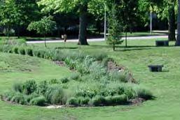


6 II. Master plan Precedents COMMUNITY GARDEN DRAINAGE FEATURE GATHERING & PLAY TRAIL / PATH 6 Master Plan for Franklin Park Metro Parks Tacoma with SiteWorkshop

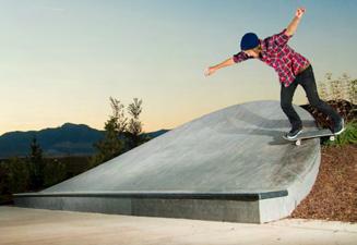
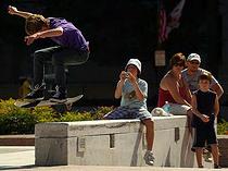
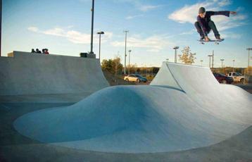
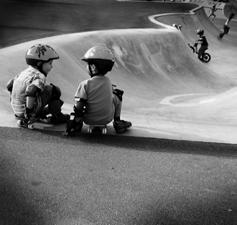

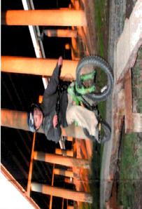
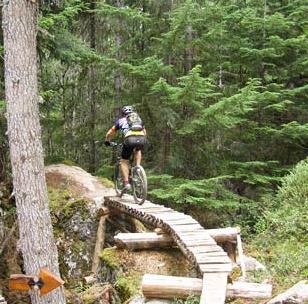


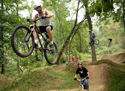
7 II. Master Plan Precedents MOUNTAIN BIKE & BMX TRAILS PLAZA / SKATE DOT SKATE BOWL Metro Parks Tacoma with SiteWorkshop Master Plan for Franklin Park 7
 in this area.")


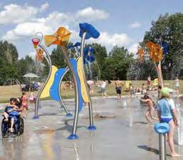
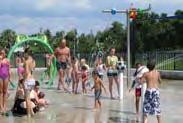
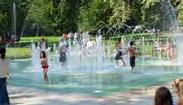
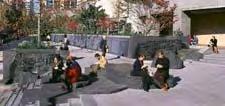
8 II. Master plan Area 1: Central Gathering Area AREA 1: Central Gathering Area This central part of the site currently consists of the most active-use areas including a wading pool, play area, picnic shelters, and an asphalt basketball court. Much of the park s circulation is centered around (originates/ends) in this area. Main park entry at S. Puget Sound Ave. Existing picnic shelter to be relocated Master Plan Recommendations Create a sense of arrival at this primary point of entry into the park. Improve circulation and ensure that there is an accessible route of travel from S. Puget Sound Ave. into the park. Provide a gathering plaza at this central node of the park with benches and picnic tables. Relocate the existing picnic shelter to the area to maximize visibility and accessibilty. Replace the existing wading pool with a new sprayground. Locate the sprayground equipment in the existing restroom and storage building. Retain the relatively new existing play area curb and ramp, but replace existing play equipment. Add a new play area for swings. The restroom building and basketball court are both in good condition and will be retained. Estimated Construction Cost: $1,010,000 Existing wading pool to be replaced with sprayground Existing restroom and play area 8 Master Plan for Franklin Park Metro Parks Tacoma with SiteWorkshop
 Metro Parks Tacoma with SiteWorkshop Master Plan for")
9 II. Master Plan Area 1: Central Gathering Area RESTROOM & MECHANICAL SWINGS PLAY AREA GATHERING S. PUGET SOUND AVE. SPRAYGROUND PICNIC SHELTER BASKETBALL COURT Central Gathering Area (NTS) Metro Parks Tacoma with SiteWorkshop Master Plan for Franklin Park 9


10 II. Master plan Area 2: Northwest Entry & Skatepark AREA 2: Northwest Entry & Skatepark Streetfront along S. 12th St. This is a predominantly open lawn area with an existing baseball field and tennis courts. The area is relatively flat overall with small slopes on its west and north sides where the open field meets S. 12th St. and S. Puget Sound Ave. There are a number of low points that do not drain well, including a large one in the existing baseball fields making the fields relatively unusable for a good part of the year. The tennis courts are in poor condition. Master Plan Recommendations Create skate plaza with the addition of a skate bowl and other skateable elements. Eliminate tennis courts. Limb trees along north border to increase visibility into park from S. 12th St. Retain baseball field in current location. Maintain open lawn for passive recreation. Provide perimeter path and connection with the circulation network at the central gathering area. North slope along S. 12th St. Estimated Construction Cost: $480,000 Open lawn and northeast slope beyond Open lawn, tennis courts, and conifers at northwest entry 10 Master Plan for Franklin Park Metro Parks Tacoma with SiteWorkshop
 Metro Parks Tacoma with SiteWorkshop Master Plan for Franklin")
11 II. Master Plan Area 2: Northwest Entry & Skatepark S. 12 TH ST. SKATE BOWL S. PUGET SOUND AVE. BASEBALL FIELD Northwest Entry (NTS) Metro Parks Tacoma with SiteWorkshop Master Plan for Franklin Park 11


12 II. Master plan Area 3: Northwest Slope & Meadow AREA 3: Northwest Slope & Meadow Edge of wooded slope This densely vegetated hillside and high point serves as the eastern boundary of the park. The understory is made up of a mix of native and non-native shrubs and groundcovers. A large portion of the area is being overtaken by understory weed species like Scotch Broom, English Ivy, and St. John s Wort, as well as invasive cherry trees. A number of social paths and a defined maintenance path traverse the area. A number of homeless camps are also present. Edge of wooded slope Master Plan Recommendations Thin hillside vegetation, remove invasive species, and restore with native plantings. Create walking and running circuit that connects with larger loop path below. Provide new entry from S. 12th St. near school entry drive. Add active recreation area (eg. BMX, Frisbee golf, etc.) Restore north facing slope by removing weeds and selectively clearing areas to increase visibility and sitelines inot and out of the park. Estimated Construction Cost: $160,000 Social path Maintenance access path 12 Master Plan for Franklin Park Metro Parks Tacoma with SiteWorkshop
 Metro")
13 II. Master Plan Area 3: Northwest Slope & Meadow S. 12 TH ST. NORTH SLOPE NEW ENTRY PERIMETER WALKING PATH MEADOW BMX TRACK FRANKLIN ELEMENTARY Northwest Slope & Meadow (NTS) Metro Parks Tacoma with SiteWorkshop Master Plan for Franklin Park 13


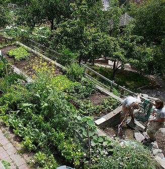
14 II. Master plan Area 4: Southeast Slope & Lawrence AREA 4: Southeast Slope & Lawrence St. This densely vegetated west-facing slope consists of both broadleaf and coniferous trees with a mixed understory. However, the overall health and phsical state of this south slope appear in be in poorer condition than the north wooded slope. The topography here consists of steep slopes that give way to a plateau on the easternmost part of the site that is bounded by S. Lawrence St. Wooded slope Master Plan Recommendations Thin part of hillside, remove invasive species, and restore with native plantings. Improve upper park at S. Lawrence St. with lawn area, trees, and furnishings. Create street end access to S. 17th St. Improve access and circulation with paths and stairs down hillside into main part of park. Improve and widen entry path along east side of community garden. Terrace hillside to accommodate expansion of community garden into lower terraces. Estimated Construction Cost: $200,000 Existing desire path that provides street-end access at S. 17th St. Degraded conditions of southeast woodland 14 Master Plan for Franklin Park Metro Parks Tacoma with SiteWorkshop
 Metro Parks Tacoma with SiteWorkshop Master Plan for")
15 II. Master Plan Area 4: Southeast Slope & Lawrence TERRACED GARDENS LAWN / UPPER PARK S. LAWRENCE ST. EXISTING COMMUNITY GARDEN Southeast Slope & Lawrence Street (NTS) Metro Parks Tacoma with SiteWorkshop Master Plan for Franklin Park 15


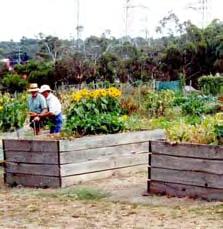
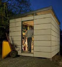
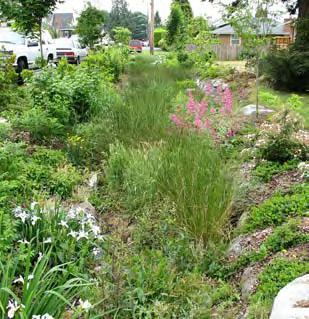
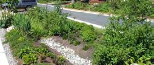
16 II. Master plan Area 5: South Lawn & Garden AREA 5: South Lawn & Community Garden South lawn and parking adjacent to community garden The southwest plateau, which is open lawn with mature trees, is perched roughly 15 feet above the adjacent central lawn and community garden. The central lawn contains several stands of mature broadleaf and coniferous trees and acts as passive open space. The community garden has about 60 usable plots and 25 plots that are seldom or never used because of the wet conditions. A small gravel parking area adjacent to the community garden is access from S. Puget Sound Ave. Existing community garden Master Plan Recommendations Maintain open southwest plateau and central lawn for passive recreation. Reorganize and expand path network. Provide perimeter path that connects to main loop path circumnavigating the park. Improve drainage with addition of bog / rain garden. Provide a tool shed in community garden. Locate a new picnic shelter in the central lawn area. Provide new benches along main loop path. Estimated Construction Cost: $220,000 Poorly drained walking paths Poorly drained soils in the garden 16 Master Plan for Franklin Park Metro Parks Tacoma with SiteWorkshop
 Metro Parks Tacoma with")
17 II. Master Plan Area 5: South Lawn & Garden BOG / RAIN GARDEN S. PUGET SOUND AVE. PICNIC SHELTER CENTRAL LAWN COMMUNITY GARDEN SOUTHWEST PLATEAU LAWN South Lawn & Community Garden (NTS) Metro Parks Tacoma with SiteWorkshop Master Plan for Franklin Park 17


18 II. Master plan Area 6: Off-Site Improvements AREA 6: Off-Site Improvements Off-site improvements include right-of-way improvements for S. Puget Sound Ave., S. Lawrence St., and S. 12th St. Improved S. Puget Sound Ave. Master Plan Recommendations Potentially provide curb, gutter, and street parking at S. Puget Sound Ave. Potentially provide curb ramps at S. 12th St., S. Puget Sound Ave., and S. Lawrence St. Provide street trees at S. 12th St., S. Puget Sound Ave., S. Lawrence St. Potentially provide stormwater quality and detention associated with street improvements. Estimated Construction Cost: $140,000 S. Puget Sound Ave. Unimproved portion of S. Puget Sound Ave. 18 Master Plan for Franklin Park Metro Parks Tacoma with SiteWorkshop


19 II. Master Plan Area 6: Off-Site Improvements S. 12 TH ST. S. 12th St. looking west S. PUGET SOUND AVE. S. 12th St. looking east S. LAWRENCE. ST. Off-Site Improvements (NTS) Metro Parks Tacoma with SiteWorkshop Master Plan for Franklin Park 19
20
ANCHORAGE PARK REPORT CARD Assessing A Park s Appearance, Function, & Condition
 ANCHORAGE PARK REPORT CARD Assessing A Park s Appearance, Function, & Condition Park Name: Is Your Park an A or an F? Your Name: Contact Information Optional: Date: General Instructions: Phone: Email:
Long Branch-Wayne Local Park Renovation Project
 Montgomery Parks Long Branch-Wayne Local Park Renovation Project Community Meeting #2 September 20, 2016 Oak View Elementary School 7:00-9:00 PM Welcome / Team Introductions M-NCPPC (Montgomery Parks)
Charles P. Johnson and Associates. Annapolis Landscape Architects
 Charles P. Johnson and Associates Annapolis Landscape Architects AGENDA Introduction Project Limits and Scope Site Analysis Opportunities & Constraints Program Goals Image Boards Design Alternatives Pros
Hedges Pond Recreation Area & Preserve
 INTRODUCTION Weston & Sampson Master Plan Presentation Hedges Pond Recreation Area & Preserve Plymouth, Massachusetts June 11, 2009 Our Priority: Completion of a Master Plan that establishes realistic
WARM SPRINGS PARK MASTER PLAN
 TABLE OF CONTENTS page 1.0 Introduction and Overview 1 2.0 Information Gathering 2 3.0 Conceptual Alternative Development 8 4.0 Master Plan Development 14 5.0 Construction Cost Estimates 19 LIST OF FIGURES
Memo Preliminary. City of Miamisburg Parks Site Reconnaissance
 Memo Preliminary To: From: Ms. Rebecca Benna Woolpert, Inc. Date: Subject: City of Miamisburg Parks Site Reconnaissance The consultant team toured the existing Miamisburg Parks to assess current levels
Errol Heights Park and Community Garden Frequently Asked Questions March 22, 2018
 Errol Heights Park and Community Garden Frequently Asked Questions March 22, 2018 Question 1: What improvements are planned for Errol Heights Park? How will the community be engaged in the process to shape
Dowdy Park. Concept Plans TOWN OF NAGS HEAD NORTH CAROLINA. Developed by: Albemarle & Associates, Ltd VHB/ Vanasse Hangen Brustlin, Inc.
 TOWN OF NAGS HEAD NORTH CAROLINA Concept Plans Developed by: Albemarle & Associates, Ltd VHB/ Vanasse Hangen Brustlin, Inc. Site Looking Southeast Dowdy Park Existing Conditions Nags Head Woods Sound Future
SOUTHEAST SPORTS COMPLEX MASTER PLAN
 REPORT TO SOUTHGATE NEIGHBORHOOD COUNCIL APRIL 13, 2016 Visioning Process April 30: Stakeholder Meeting with Sports Groups May 5: Stakeholder Meeting with Southgate Land Use Committee May 13: SNC Meeting
WILLIAM PAYNE SPORTS PARK MASTER PLAN BOARD OF DIRECTORS PRESENTATION
 WILLIAM PAYNE SPORTS PARK MASTER PLAN BOARD OF DIRECTORS PRESENTATION December 12, 2018 PROJECT OVERVIEW GOALS OF MASTER PLAN 1. Engage Community in Master Plan Process 2. Maximize Park Space for Sports
BISCUIT RUN PARK MASTER PLAN
 BOARD OF SUPERVISORS November 14, 2018 BISCUIT RUN PARK MASTER PLAN COUNTY OF ALBEMARLE ANHOLD ASSOCIATES Contents Project Introduction Property Background County Park Planning Process Existing Site &
A.9. Cannon River. Campostella Park. Adjacent Industrial & City Facility Uses
 Campostella Park Classification: Nature Area 14 acres Character: This park is an undeveloped, heavily wooded natural open space park located along the Cannon River, just to the southwest of Babcock Park
JCB & MIAMI SEWER SEPARATION PROJECT & ADAMS PARK WETLAND
 JCB & MIAMI SEWER SEPARATION PROJECT & ADAMS PARK WETLAND 30% Public Meeting November 29 th, 2012 ADAMS PARK MASTER PLAN H3 Studio Tonight s Agenda Review Adams Park Master Plan (H3 Studio) Context & Analysis
Benedict Fountain Park Meeting Notes Wednesday, February 15, 2012
 Benedict Fountain Park Meeting Notes Wednesday, February 15, 2012 ALTERNATIVE #1 Like the big open lawn space in alternative 1. Like cohesiveness of sidewalk walk and play areas shown on alternative 1
CHAPPLES PARK MASTER PLAN. Presentation to Council April 10, 2017
 CHAPPLES PARK MASTER PLAN Presentation to Council April 10, 2017 1 PRESENTATION AGENDA 1. Project Background, Aim and Process 2. The Site Issues and Opportunities 3. Community Engagement 4. Vision and
New Park / Entry Court & Plaza Concept Design
 New Park / Entry Court & Plaza Concept Design The SECC Public realm is proposed to have a focus on health, wellness, and community and that site users will include patrons of the neighbourhood. The block
TA B L E O F C ON T EN T S
 TA B L E O F C ON T EN T S Introduction 1 Site Analysis 2 EXISTING TREE ANALYSIS 3 Community Outreach 5 PUBLIC WORK SHOP #1 GENERAL PUBLIC 6 PUBLIC WORKSHOP #2 4 TH OF JULY CELEBRATION 9 PUBLIC WORKSHOP
BOARD OF TRUSTEE MEMORANDUM
 1 15 17 2 12 14 19 18 13 11 3 10 6 16 5 4 9 8 7 BOARD OF TRUSTEE MEMORANDUM TO: HONORABLE MAYOR & BOARD MEMBERS FROM: JANET ALUISE, COMMUNITY DEVELOPMENT DIRECTOR DATE: OCTOBER 2, 2012 RE: MASTERPLANNING
South East Sports Complex Phase I
 South East Sports Complex Phase I City of Spokane Design Review Board August 29, 2018 (Revised) Objectives 1. Early discussion and collaboration. 2. Provide framework / catalyst for future improvements
A 2012 Clean and Safe Neighborhood Parks Bond Project. Katy Tang, District Supervisor. Jasmine Kaw, Landscape Architect Will Kwan, Architect
 West Sunset Park A 2012 Clean and Safe Neighborhood Parks Bond Project Community Meeting #2 November 20, 2013 Katy Tang, District Supervisor Dan Mauer, Project Manager Jasmine Kaw, Landscape Architect
Terrace View Park. Master Plan
 Terrace View Park Master Plan Table of Contents Terrace View Park Master Plan Page Executive Summary 1 Project Background 3 Master Planning Process Existing Conditions Master Plan 9 Park Zones and Amenities
russell+mills studios
 S C H E M A T I C D E S I G N B O O K L E T O C T O B E R 2 2, 2 0 0 8 114 east oak st, fort col TABLE OF CONTENTS...ii SITE CONTEXT...1 BACKGROUND...2 PARK PROGRAM...3 SLOPE ANALYSIS...4 SPATIAL ANALYSIS...5
A cknovvledgements. Table of Contents. Project Introduction...1
 Pashek Asscx::iates MARCH2007 A cknovvledgements Pashek Associates would like to thank Jackson Township and the Jackson Township Recreation Board for their valuable contributions, support, and input during
SOUTH PARK. Construction of a Portion of South Park at Fresh Kills Park, Staten Island
 SOUTH PARK Construction of a Portion of South Park at Fresh Kills Park, Staten Island FRESHKILLS PARK FIRST PHASE OF SOUTH PARK FRESHKILLS PARK CONTEXT SOUTH PARK EXISTING CONDITIONS PROJECT OPPORTUNITIES
SH 199 Corridor Master Plan. Community Meeting No. 2 May 31, 2017
 Community Meeting No. 2 May 31, 2017 Transportation Projects On or Near SH 199 SH 199 from 0.3 miles south of FM 1886 to south end of Lake Worth bridge Construct freeway mainlanes and frontage roads 10-Year
2. Analysis. DRAFT Gerald Richards & Pleasantview Park Master Plan
 DRAFT Gerald Richards & Pleasantview Park Master Plan 19 Historic Features According to the National Register of Historic Places and the National Historic Landmarks Program, there is nothing of national
Master Plan. of a new entry ramp as depicted on the Proposed First Floor Plan.
 Master Plan The completed Master Plan is an aggregation of the input gathered in the focus group, steering committee, staff and public open house meetings. The Design Team completed the Draft Master Plan
RECREATION AND OPEN SPACE VISION
 City of South Lake Tahoe General Plan Policy Document Recreation and Open Space Element INTRODUCTION This element provides the policy context for the City of South Lake Tahoe to achieve its vision for
February 27, 2018 City Council Presentation The Crown Jewel Park in the City of Fairfax
 February 27, 2018 City Council Presentation The Crown Jewel Park in the City of Fairfax Master Planning Charge Van Dyck Park s first Master Plan will provide the City with a road map as to how best incorporate
Design Alternatives Workshop. Hilfiker Park Master Plan Workshop #2
 Design Alternatives Workshop Hilfiker Park Master Plan Workshop #2 Agenda for Tonight Staff Presentation (40 min) Introduction Master Plan Process Planning Context What We ve Heard So Far Design Alternatives
AVONDALE ESTATES GREENSPACE AD-HOC COMMITTEE
 AVONDALE ESTATES GREENSPACE AD-HOC COMMITTEE INVENTORY AND RECOMMENDATIONS REPORT November 7, 2018 Our Mission Statement: To provide assistance and support, through professional expertise in matters of
PARKS & RECREATION SUBCOMMITTEE. Oct. 1, 2015
 PARKS & RECREATION SUBCOMMITTEE Oct. 1, 2015 1999 Bond - $22,000,000 Land Acquisition Allen Station Phase II Neighborhood Parks PREVIOUS BOND ELECTIONS 1999 & 2007 2002 Bond - $4,000,000 Allen Senior Recreation
CHAPPLES PARK MASTER PLAN
 CHAPPLES PARK MASTER PLAN Presentation of Preliminary Development Options Public Open House #2 Wednesday November 2 nd, 2016 TONIGHT S AGENDA 1. Welcome & Introductions 2. Presentation by Sierra Planning
Throughout. square. (Crystal City Vision Plan 2050)
") 1: Terms related to the PSMP document 1 public space (see also public realm, civic space) An open space designated on the regulating plan, accessible to all, including Plazas, Mini Parks, and Neighborhoods
1: Terms related to the PSMP document 1 public space (see also public realm, civic space) An open space designated on the regulating plan, accessible to all, including Plazas, Mini Parks, and Neighborhoods
7.0 OPEN SPACE 7.1 OPEN SPACE DEDICATION CHAPTER 7: OPEN SPACE
 7.0 OPEN SPACE The intent of these requirements is to allow for the usage of centrally located unencumbered land as neighborhood open spaces and not to permit the use of leftover or otherwise unusable
A LONG RANGE PLAN FOR PARKS AND OPEN SPACES
 A LONG RANGE PLAN FOR PARKS AND OPEN SPACES Town of Lisbon Park Committee Waukesha County, Wisconsin 1 Ver. 2.1 May 2017 A LONG RANGE PLAN FOR PARKS AND OPEN SPACE TOWN of LISBON WAUKESHA COUNTY, WISCONSIN
SITE FEASIBILITY TEST FIT LAYOUT NORTHERN AREA INTERNATIONAL SCHOOL DECEMBER 2016
 SITE FEASIBILITY TEST FIT LAYOUT NORTHERN AREA INTERNATIONAL SCHOOL DECEMBER 2016 OWNER & DESIGN TEAM GENERAL BACKGROUND INFORMATION PGCPS received a Carnegie Corporation Opportunity by Design grant to
Park Types and Attributes
 02 APPENDIX B APPENDIX B s and s 194 APPENDIX B 04 Size Level of Service Any privately owned park, of any size, is a neighborhood park Primary Service Area - 1/2 mile or within 15 minutes walking distance
APPENDIX D: PARKS AND RECREATION ACTION PLAN
 APPENDIX D: PARKS AND RECREATION ACTION PLAN Goals The following goals are specific to the development, maintenance, and operation of the existing parks in the Township, as well as the acquisition and
Appendix 1. Private Projects with Respective On Site PUS and Public Parks in the Silver Spring CBD
 Appendix 1 Private Projects with Respective On Site PUS and Public Parks in the Silver Spring CBD Green Space Guidelines for the Silver Spring Central Business District montgomery county planning board,
UNIVERSITY OF MICHIGAN:
 Chapter Eight UNIVERSITY OF MICHIGAN: North Campus I. Introduction The University of Michigan currently owns approximately 800 acres of land in the northeast section of Ann Arbor. North Campus refers to
The urban parks in Charlottesville include Jackson Park, Lee Park, and McGuffey Park.
 Park Classifications Charlottesville s parks can be grouped into 4 different classifications: urban parks, neighborhood parks, community parks, and regional parks. Figure 1 on page 5 inventories the facilities
TOPS K-8. Teacher Guide. CONTENTS Stormwater in the Schoolyard Lesson 3
 CONTENTS Stormwater in the Schoolyard Lesson 3 Local Stormwater Systems Lesson 5 Stormwater in Our Community Lesson 6 TOPS K-8 Teacher Guide How to Use This Guide This guide supports the Community Waters
Public Recreation Spaces. Brian E. Saelens, Lawrence D. Frank, Christopher Auffrey, Lauren Elise Leary,
 Environmental Assessment of Public Recreation Spaces Preliminary i Data for ALRConference Brian E. Saelens, Lawrence D. Frank, Christopher Auffrey, Lauren Elise Leary, Robert C. Whitaker, Hillary Burdette
South Bend Park. Visioning Plan
 South Bend Park Visioning Plan 2007 South Bend Park, Visioning Program, Executive Summary The South Bend Park Visioning Program began with the receipt of an application from the Friends of South Bend Park,
nokomis-hiawatha regional park master plan and park improvements
 master plan and park improvements CAC Workshop # August 26th, 2014 charge of the cac The Nokomis Hiawatha Regional Park CAC shall: Become knowledgeable about the project and its scope Understand and represent
Minto-Brown Island. November 18, City of Salem, Parks & Transportation Services
 Minto-Brown Island Park Master Plan Public Meeting #1 November 18, 2014 City of Salem, Parks & Transportation Services Division, i i Public Works Welcome... and thanks for participating in the master planning
Canal Winchester Parks Master Plan. Public Meeting 2 Thursday, February 2 6:30pm
 Canal Winchester Parks Master Plan Public Meeting 2 Thursday, February 2 6:30pm Meeting Agenda 1. Project overview 2. Project schedule 3. Public input results Survey Public Meeting #1 Stakeholder Interviews
Chapter 6. Overall Vision RECOMMENDATIONS. More Trail and Trail. Connections. Equal Access to Park. Facilities and Programs. Water Access.
 Overall Vision More Trail and Trail Connections Equal Access to Park Facilities and Programs Water Access Environment Variety Chapter 6 RECOMMENDATIONS Chapter 6 The following recommendations for park,
Gas Works Site Land-Use Study
 City of New Westminster Background Context 2 Neighbourhood Context 3 Program Elements 4 Proposed Site Planning Approach 5 Design Rationale 10 Design Elements 11 Phasing 21 C o n t e n t s b a c k g r o
30% DRAFT GAINSBORO PARK IMPROVEMENT PROJECT THE CITY OF PLEASANT RIDGE CITY OF PLEASANT RIDGE, OAKLAND COUNTY, MICHIGAN
 LEGAL PROPERTY DESCRIPTION SEE NOTES SHEET FOR LEGAL PROPERTY DESCRIPTIONS THE CITY OF PLEASANT RIDGE GAINSBORO PARK IMPROVEMENT PROJECT CITY OF PLEASANT RIDGE, OAKLAND COUNTY, MICHIGAN 4444 Second Avenue
Play areas overlooking climbing hill. School & playgrounds overlooking pond bottom ballfields. Project experience while at Loris and Associates, Inc.
 City of Thornton Parks & Open Space Cherrywood Park Thornton, CO Architect: Design Concepts Construction of this seven-acre City park, located adjacent to Adams Twelve Five Star Prairie Hills Elementary
Community Engagement Committee Meeting #1 December 10, :30pm-8:30pm
 Community Engagement Committee Meeting #1 December 10, 2014 6:30pm-8:30pm Welcome and Introductions Dana Murdoch Minneapolis Park and Recreation Board Project Manager Ryan French Walker Art Center Director
PARK PLANS OPERATIONS AND MAINTENANCE EAST OF THE RIVER PARK MASTER PL AN
 INTRODUCTION PLANNING PROCESS SERVICE AREA VISION PARK PLANS OPERATIONS AND MAINTENANCE IMPLEMENTATION 4 PARK PLANS EAST OF THE RIVER PARK MASTER PL AN 67 THIS PAGE WAS INTENTIONALLY LEFT BLANK NEIGHBORHOOD
Montgomery Park Revitalization Plan
 Montgomery Park Revitalization Plan December 22, 2015 Prepared by: Rick Manning, ASLA Maggie Soulstein Prepared by: Montgomery Park Revitalization Committee Table of Contents Background... 1 Description
January 11, New benches installed. Paving of parking lot adjacent to piers and the canoe put-in. Near complete with clean up remaining.
 Project Updates January 11, 2018 CENTERVILLE CHESAPEAKE ARBORETUM BELLS MILL CITY CREEKWOOD SOUTH DEEP CREEK LOCK WORK TO BE PERFORMED/UPDATES Improvements to the parking lot include installation of a
PEQUITSIDE FARM ONE PROPERTY, MANY USES
 PEQUITSIDE FARM ONE PROPERTY, MANY USES Laura Campbell March 8, 2016 A plan for the public use of a historic estate Introduction At 33 acres, Peuitside Farm is the largest public owned open space in the
MUNICIPALITY OF ANCHORAGE
 MUNICIPALITY OF ANCHORAGE ANCHORAGE PARKS & RECREATION PRC # 09-52 a DATE: November 2, 2009 TO: FROM: Park and Recreation Commission Suzanne R. Little, Senior Park Planner SUBJECT: Valley of the Moon Park
Marshview Park. Concept Briefing and Feedback Session. Aquarium/Owls Creek Plan Steering Committee March 20, 2012
 Marshview Park Concept Briefing and Feedback Session Aquarium/Owls Creek Plan Steering Committee March 20, 2012 1 Outline of Today s Discussion Introductions Context for Marshview Park Site analysis -
Southeast Quadrant Plan
 Southeast Quadrant Plan Southeast Quadrant Distinctive Features Land Use The Southeast Quadrant includes all the area within the planning area that is east of Interstate 5 and south of State Route 44.
LELAND & VISITACION PARK COMMUNITY MEETING
 LELAND & VISITACION PARK COMMUNITY MEETING July 16th, 2016 SAN FRANCISCO RECREATION AND PARK GLS LANDSCAPE ARCHITECTURE BAYSIDE DEVELOPMENT LLC MEETING OBJECTIVES 1. FEEDBACK ON LELAND / BAYSHORE CORNER
Silver Creek Subdivision Public Park
 Silver Creek Subdivision Public Park Design Team: team80026 Munding Design Lead Consultant Gaia Designs Landscape Architect Wildrye Design Landscape Architect Akamai Design Civil Engineer introduction
Chris James Park Planner July 16, Master Plan Kick Off Meeting
 Chris James Park Planner July 16, 2014 Master Plan Kick Off Meeting Meeting Overview Introductions Purpose of Meeting and Master Plan History & Background of Park Property Prior Planning Considerations
Bullhead City Rotary Park Plan Update
 Bullhead City Rotary Park Plan Update PLANNERS/LANDSCAPE ARCHITECTS: RBF Consulting 16605 N 28 th Avenue Suite 100 Phoenix, Arizona 85053-7550 (602) 467-2200 CIVIL ENGINEER: RBF Consulting 16605 N. 28
City Council March 27, Parks, Recreation, and Trails Master Plan
 City Council March 27, 2018 Parks, Recreation, and Trails Master Plan Planning Process Develop Goals and Objectives Inventory of Areas and Facilities Needs Assessment And Identification Public Participation
Update on Angus Glen. Community Park. Development Services Committee. December 6, Part A ANGUS GLEN PARK MASTER PLAN. Town of Markham & LA+ED
 Update on Angus Glen Community Park Part A Development Services Committee December 6, 2011 Agenda Overview of Project Background Current Project Status Proposed Park Program and Activities Revised Master
Design Specifications & Requirements Manual
 11 PARKS & OPEN SPACES 11.1 DEFINITIONS... 1 11.1.1 Neighbourhood Parks... 1 11.1.2 District Parks... 1 11.1.3. Sport Parks... 1 11.1.4 Urban Parks... 1 11.1.5 Civic Spaces... 1 11.1.6 Open Space System...
Garden edges provide vertical plantings to buffer the neighbors from the building facilities around the entire campus.
 Open Space Existing Open Space Children s intends to maintain the landscape as a garden around the campus to help children heal while providing spaces for visitors, caregivers, staff and neighbors. Children
Design Considerations
 Essential to the development of a successful Master Plan for the Park Complex is input from the community that the park will serve. The community outreach component of the planning process included numerous
City of Bonney Lake Allan Yorke Park. MASTER PLAN SUMMARY REPORT June 30, 2016
 City of Bonney Lake Allan Yorke Park MASTER PLAN SUMMARY REPORT June 30, 2016 TABLE OF CONTENTS INTRODUCTION PUBLIC INVOLVEMENT PROCESS MASTER PLAN North Park Central Park South Park East Park Field Development
SF REC & PARK STANYAN STREET IMPROVEMENT. Supervisor London Breed District 5. Project Manager Dan Mauer Recreation and Parks Department
 SF REC & PARK STANYAN STREET IMPROVEMENT PLANNING PRESENTATION WEDNESDAY, OCTOBER 19, 2016 Supervisor London Breed District 5 Project Manager Dan Mauer Recreation and Parks Department Design Team William
Caroline Freeland Park Facility Plan Project
 Montgomery Parks Caroline Freeland Park Facility Plan Project Community Meeting #1 November 6, 2013 Bethesda Library 7:00-9:00 PM Welcome / Team Introductions Parker Rodriguez, Incorporated (Landscape
Project purpose. advise. The purpose of the Beaumaris Lake Open Space Rehabilitation project is to: + Develop a Functional Program Concept
 Project purpose owns Road Beaumaris Road The purpose of the Beaumaris Lake Open Space Rehabilitation project is to: + Develop a Functional Program Concept + Guide Rehabilitation of Landscape and Community
master plan hodge park
 KCMO Parks & Commissioners Recreation Board of Parks & Recreation Kansas City, Missouri Mark McHenry Director Heather Runkel Project Manager LAND3 Studio L.L.C. Bob G Bushyhead Principle Michael H Malyn
PHASE 3-4 PARKS SOUTH PARK AND CHANNEL PARK
 PHASE 3-4 PARKS SOUTH PARK AND CHANNEL PARK Sheet List L1.0 L2.0 L3.0 L4.0 L5.0 L6.0 L7.0 L8.0 L9.0 L10.0 L11.0 L12.0 L13.0 L14.0 L15.0 L16.0 L17.0 L18.0 L19.0 L20.0 L21.0 L22.0 Cover Open Space Context
ARTICLE IV: DEVELOPMENT STANDARDS 404 MASTER PLANNING
 IV 13 404 MASTER PLANNING Master Planning through the Site Analysis (Master Planning Site Analysis) or Planned Development (Master Planning Planned Development) is provided to encourage development which
Focus Groups. 8 Focus Group meetings including 2 with staff, 1 with seniors, and 1 with students
 Project Team Nan Lanahan, Parks & Recreation Jason Gallo, Parks & Recreation Rob Leslie, DEDP John Smolinsky, Planning Board Brent Meredith, Highway Joan Gavrilik, Friends of Parks & Rec MaryLyn Koval,
NORTH DISTRICT. Description
 VI plan and major recommendations district plans north disrict NORTH DISTRICT Description The North District comprises approximately 105 acres and is bounded by two important bio-habitats and corridors
Outdoor Recreation Facilities Inventory
 Outdoor Recreation Facilities Inventory Allouez Neighborhood Parks: East Lawn Park (4.90 acres) is located in the northeastern corner of Allouez near Boyd Street. This site contains: Baseball diamond with
1. Parks & Recreation Neighborhood Parks Community Parks Special Use Sites 2. Open Space 3. Trails
 Appendix A: Park Classifications The intent of parks and recreation classifications is to aid in making acquisition and design decisions for park sites, facilities and the organization of recreation space
ALTERNATIVE STATION AREA -
 ALTERNATIVE STATION AREA - THE 10 TH STREET GARDEN STATION Two alternative land use scenarios and designs are illustrated here: Scheme A - Transit-Oriented Development High to Mid-Density Residential /Office
100 Dix Drive Conceptual Master Plan. Wyatt Thompson, PLA, ASLA, Assistant Director Lindsay Stucki, Intern Park Planner
 100 Dix Drive Conceptual Master Plan Wyatt Thompson, PLA, ASLA, Assistant Director Lindsay Stucki, Intern Park Planner Final Draft Prepared August 2018 Introduction On September 20, 2016, the City of Manhattan
ACADEMY AREA CONCEPT PLAN
 ACADEMY AREA Strip ling C hape l Roa d CONCEPT PLAN 7 S2 U Stripling 52 ROADWAYS AND PARKING: ADVENTURE PLAYGROUND AND SPRAYGROUND: Current roadways follow existing drives. It is recommended that the Folds
Planning Stage. Mosaic Park. Long Term Project. Restoration of 4 Mile Run. Planning Stage. Herndon and 13 th. Project Underway. Clarendon Central Park
 Planning Stage Long Term Project Planning Stage Project Underway Mosaic Park Restoration of 4 Mile Run Herndon and 13 th Clarendon Central Park Arlington County Parks, Recreation and Cultural Resources
Highbridge Park Enhance the picturesque park: Provide more opportunities for healthy activity: Improve forest and ecology health:
 Enhance the picturesque park: Expose gigantic rocks and meadows Provide more opportunities for healthy activity: Improve the recreation center, athletic fields, playgrounds & restrooms Improve forest and
Project Team. 2M Associates. City of Saratoga. HT Harvey Biology. PlaceWorks. NV5 Infrastructure. Tom Origer Associates History/Archeology
 Project Team City of Saratoga John Cherbone, Director of Public Works Iveta Harvancik, Senior Engineer PlaceWorks Isabelle Minn, Principal-in-Charge Isby Fleischmann, Project Manager Kyle Simpson, CEQA
Wildflowers grow in the new community park on Oakwood Road
 Wildflowers grow in the new community park on Oakwood Road PLANNING AREA - NEW PARKS An important element in the plan for the City of Delafield is to look ahead for future park needs. The City has the
for Master Planned Development Framework Design Standards & Guidelines
 B L A C K D I A M O N D DE S I G N G U I D E L I N E S for Master Planned Development Framework Design Standards & Adopted June 18, 2009 Introduction and Purpose The Master Planned Development (MPD) Framework
VISION PLAN PRESENTATION - SEPTEMBER 28, 2013
 AREAS OF IMPROVEMENT E A POOL HOUSE POOL DECK B B MAIN BUILDING UPPER PLAZAS A D F G C MAJOR BLEACHERS DUGOUTS FIELD MAIN COURTYARD D REGGIE PARK C E SPORT COURT ADA RAMP H F G H TENNIS COURTS KITCHENETTE
PIERCE COUNTY IMPACT FEE WORKING GROUP. Pierce County s Park System
 PIERCE COUNTY IMPACT FEE WORKING GROUP Pierce County s Park System Project Title 2/25/2016 1 Pierce County s Park System Park System Concept Park Classifications Current Park Inventory Park System Comparison
LANDSCAPE MASTER PLAN. JAMS Dream Big!
 J A N E A D D A M S M I D D L E S C H O O L L A N D S C A P E M A S T E R P L A N 2 0 1 8 TABLE OF CONTENTS EXECUTIVE SUMMARY PROCESS SITE ANALYSIS LANDSCAPE MASTER PLAN (LMP) APPENDIX ACKNOWLEDGEMENTS
The Recreational Heart of Cannington - MacLeod & Claire Hardy Parks
 The Site Claire Hardy Park and MacLeod Park are both located within the community of Cannington on opposing shorelines of the Beaver River and are accessible to each other by a footbridge spanning the
Mt Baker Park Safe Access Project
 Mt Baker Park Safe Access Project PROJECT TEAM Greg funk, stairway inspector karen selander, project manager pam kliment, neighborhood planner Property Owner Development / Design Guidelines Project oversight
Appendix E Section 4(f) Evaluation
 Evaluation") Appendix E Section 4(f) Evaluation Appendix E Draft Section 4(f) Evaluation E.1 Introduction This appendix addresses a federal regulation known as Section 4(f), which protects parks, recreation areas,
Appendix E Section 4(f) Evaluation Appendix E Draft Section 4(f) Evaluation E.1 Introduction This appendix addresses a federal regulation known as Section 4(f), which protects parks, recreation areas,
3. VISION AND GOALS. Vision Statement. Goals, Objectives and Policies
 Vision Statement Queen Creek s interconnected network of parks, trails, open spaces and recreation opportunities provide safe and diverse activities and programs that sustain its unique, small town, equestrian
Master Plan Presentation August 12, 2015
 Master Plan Presentation August 12, 2015 A vision for tomorrow... May, 13 2015 prepared for: prepared by: SITE LOCATION SITE NTS SITE ANALYSIS +/- 17.8 Ac. RESIDENTIAL HOMES 1 2 RAIL ROAD (SAFETY CONCERNS)
Eastcreek Farm. Planned Development Standards September, 2014
 Eastcreek Farm Planned Development Standards September, 2014 ekfarm Contents 01. General Standards 02. Residential Development Standards 03. Architectural Design Standards 04. Landscape Design Standards
Monte Cecilia Park DRAFT CONCEPT PLAN FEBRUARY 2015 AUCKLAND COUNCIL
 Monte Cecilia Park DRAFT CONCEPT PLAN FEBRUARY 2015 AUCKLAND COUNCIL 1 Site analysis and concept 1.1 Location Site Extent MT ALBERT RD HILLSBOROUGH RD BUDOCK RD MONTE CECILIA PARK KORMA RD HERD RD Figure
Chapter Purpose and Intent. 7.2 Applicability. 7.3 General Provisions RECREATIONAL OPEN SPACE
 Chapter 7. RECREATIONAL OPEN SPACE 7.1 Purpose and Intent The intent of this Chapter is to provide for centrally located, unencumbered land as neighborhood recreational open space and not to permit the
Design Specifications & Requirements Manual
 11 PARKS & OPEN SPACES 11.1 DEFINITIONS... 1 11.1.1 Neighbourhood Parks... 1 11.1.2 District Parks... 1 11.1.3. Sport Parks... 1 11.1.4 Urban Parks... 1 11.1.5 Civic Spaces... 1 11.1.6 Open Space System...