Lone Oak Road/ 70 th Street West. Efficient, Effective, Responsive. Preliminary Design Services (CP 26-54)
|
|
|
- Conrad Hicks
- 6 years ago
- Views:
Transcription

1 (CP 26-54) Dakota County Board of Commissioners September 12, 2017
2 Purpose of Request Award Design Contract to Kimley-Horn and Associates Approve Joint Powers Agreements with the Cities of Eagan and Inver Grove Heights Amend the 2017 Transportation Capital Improvement Program (CIP) Budget

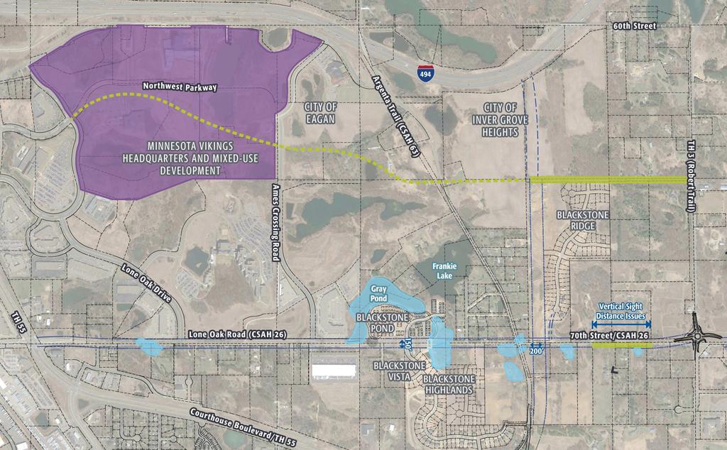
3 Project Location
4 Project History In 2010, the Regional Roadway System Visioning Study (RRSVS) was adopted for the northeast area of Eagan and the northwest area of Inver Grove Heights. The RRSVS recommended the expansion of Lone Oak Road/ 70 th Street West to 4 lanes from TH 55 in Eagan to Athena Way (just west of Babcock Trail (CR 73)) in Inver Grove Heights.
5 Current RRSVS Projects: 1. CP (Argenta Trail Realignment) Project realigned and expanded Argenta Trail from south of Trunk Highway (TH) 55 to Amana Trail to a 4 lane roadway 2. CP (70 th Street West & TH 3 Roundabout) Project will construct a roundabout at the intersection of 70 th Street West and South Robert Trail (TH 3)
6 Factors To Consider 1. Residential development in Inver Grove Heights 2. Redevelopment in Eagan 3. Vikings Development 4. Existing peak hour delays at Argenta intersection 5. Future alignment of County Multi-use trails and connections to the County s greenway system
7
8 Determine the alignment for a divided 4 lane roadway. Evaluate possible options for the existing and future 70 th Street West and Argenta Trail intersection Design regional basins and ponding areas to meet City Standards Implement an effective public engagement plan Open Houses, Stakeholder meetings, newsletters Determine the necessary right of way limits Roadway Regional basins and ponding areas

9 Project Corridor

10 70 th St. W. & Argenta Trail Intersection
11 Consultant Selection Request for proposals (RFP) was sent to 4 consulting firms. Three firms proposed on the project: SRF Consulting, Inc., Bolton and Menk and Kimley-Horn and Associates. Kimley-Horn was selected as the best value consultant
12 Consultant Selection The Kimley-Horn Team proposal included: Project area familiarity Effective public engagement plan Design team with storm water design experience. Additional option for the 70 th Street West and Argenta Trail intersection Additional preliminary design hours
13 CP Project Schedule Award Consultant Contract: September 12, 2017 Begin Design Work: October 2017 Open House #1: Late Oct./ Early Nov Open House #2: March 2018 Design Complete: May 31, 2018 Draft CIP R/W Acquisition: Planned Construction: 2020
14 Project Budget Project Cost: $395,090 Project Revenue: $326,559 Budget Amendment*: $ 68,531 *Sufficient funds of $68,531 are available in the 2017 Transportation Capital Improvement Program (CIP) budget for an amendment to the CP budget.
15 Recommended County Board Actions: 1. Award consultant contract to Kimley-Horn and Associates 2. Approve Joint Powers Agreement (JPA) with the Cities of Eagan and Inver Grove Heights for Preliminary Design. 3. Amend the Transportation Capital Improvement Program (CIP) Budget
ARGENTA TRAIL (CSAH 28/63) REALIGNMENT SOUTH PROJECT (CP 63-25)
 REALIGNMENT SOUTH PROJECT (CP 63-25)") ARGENTA TRAIL (CSAH 28/63) REALIGNMENT SOUTH PROJECT (CP 63-25) Preliminary Design Report February 2015 Prepared For: City of Inver Grove Heights Dakota County Prepared By: Kimley-Horn and Associates,
ARGENTA TRAIL (CSAH 28/63) REALIGNMENT SOUTH PROJECT (CP 63-25) Preliminary Design Report February 2015 Prepared For: City of Inver Grove Heights Dakota County Prepared By: Kimley-Horn and Associates,
Mendota-Lebanon Hills Greenway Master Plan Executive Summary. August draft for more information visit
 Mendota-Lebanon Hills Greenway Master Plan Executive Summary August 2013 draft for more information visit www.hkgi.com/projects/dakota INTRODUCTION The Mendota-Lebanon Hills Greenway Master Plan portrays
OPEN HOUSE #3. Project Manager Kristi Sebastian, PE, PTOE
 OPEN HOUSE #3 Project Manager Kristi Sebastian, PE, PTOE kristi.sebastian@co.dakota.mn.us 952-891-7100 WHY ARE WE CONDUCTING THE ARTERIAL CONNECTOR STUDY? Dakota County and the cities of Rosemount, Inver
Metropolitan Parks and Open Space Commission
 Business Item No. 2013-xxx Metropolitan Parks and Open Space Commission Meeting date: October 1, 2013 For the Community Development Committee meeting of October 7, 2013 Subject: Mendota-Lebanon Hills Greenway
Rich Valley Greenway Master Plan. Central Greenway Connectivity Study
 Rich Valley Greenway Master Plan Central Greenway Connectivity Study Dakota County Planning Commission February, 2017 Rich Valley Greenway Master Plan Dakota County Greenway Vision Establish a County-wide
REQUEST FOR COUNCIL ACTION 6A AGENDA ITEM ORIGINATING DEPT. AGENDA ITEM CITY ADMINISTRATOR APPROVAL
 DATE REQUEST FOR COUNCIL ACTION 6A AGENDA ITEM ORIGINATING DEPT. AGENDA ITEM CITY ADMINISTRATOR APPROVAL Community Development Territorial Greens PUD Concept Plan Development Stage Plan Subdivision (Preliminary
CITY OF INVER GROVE HEIGHTS A G E N D A CITY COUNCIL WORK SESSION June 3, :00 PM INVER GROVE HEIGHTS CITY HALL COUNCIL CHAMBERS
 CITY OF INVER GROVE HEIGHTS A G E N D A CITY COUNCIL WORK SESSION June 3, 2013 6:00 PM INVER GROVE HEIGHTS CITY HALL COUNCIL CHAMBERS 1. CALL TO ORDER Mayor Tourville 2. RENTAL REGULATIONS 3. FRONT YARD
STORM WATER UTILITY FREQUENTLY ASKED QUESTIONS
 STORM WATER UTILITY FREQUENTLY ASKED QUESTIONS In 2007, the City Council adopted Ordinance No. 1155 establishing a storm water utility in the City. No fee structure was adopted at that time. The idea of
Implementation Guide Comprehensive Plan City of Allen
 Implementation Guide 2030 Comprehensive Plan City of Allen DRAFT 2015 Implementation Guide Allen 2030 Comprehensive Plan INTRODUCTION The Comprehensive Plan serves as a guide for the growth and development
4/8/2015 Item #10D Page 1
 MEETING DATE: April 8, 2015 PREPARED BY: Christy Villa, Associate Civil Engineer DEPT. DIRECTOR: Glenn Pruim DEPARTMENT: Public Works CITY MANAGER: Larry Watt SUBJECT: NORTH COAST HIGHWAY 101 STREETSCAPE
Planning and New Starts Development Committee. February 25, 2016
 Planning and New Starts Development Committee February 25, 2016 VB TRANSIT EXTENSION 2 Status of VBTES DEIS No Federal Environmental Decision Document Decision to build project with only State and City
12 Intergovernmental Coordination
 Intergovernmental Coordination Supporting Data The purpose of the Intergovernmental Coordination Element is to identify and resolve incompatible goals, objectives, policies and development proposed in
Capital Projects in and near Odenton Town Center
 Capital Projects in and near Odenton Town Center Map ID Anne Arundel County Department of Public Works This project provides for the design, right of way acquisition, and construction of approximately
Corridor Management Committee. September 29, 2017
 Corridor Management Committee September 29, 2017 1 Today s Topics Chair s Update Proposed Corridor Protection Wall Aesthetic Design Overview Public Outreach Environmental Review Civil Construction Update
Rosemount Greenway Master Plan Executive Summary. draft. Spring for more information visit
 Rosemount Greenway Master Plan Executive Summary Spring 2012 draft for more information visit www.hkgi.com/projects/dakota INTRODUCTION The Rosemount Greenway Master Plan portrays a vision to establish
5-E ====================================================== -==-= ====================================================
 PALM BEACH COUNTY BOARD OF COUNTY COMMISSIONERS 5-E AGENDA ITEM SUMMARY ------------====================================================== Meeting Date: September 11, 2007 Department: [] [] Consent [ ]
CITY OF CHARLOTTESVILLE, VIRGINIA CITY COUNCIL AGENDA
 CITY OF CHARLOTTESVILLE, VIRGINIA CITY COUNCIL AGENDA Agenda Date: December 16, 2013 Action Required: Adoption of Resolution Presenter: Staff Contacts: Title: James E. Tolbert, AICP, Director of NDS James
Transportation Committee
 Transportation Committee Business Item No. 2013-286SW Meeting date: October 14, 2013 For the Metropolitan Council meeting of October 16, 2013 Subject: Southwest Light Rail Transit (Green Line Extension):
The transportation system in a community is an
 7 TRANSPORTATION The transportation system in a community is an important factor contributing to the quality of life of the residents. Without a sound transportation system to bring both goods and patrons
Welcome to the. Open House
 Welcome to the 5th Street to Kinsman Road Open House November 14 5:30 7:00 p.m. Please sign in Project Overview In December 2016, City Council adopted SW 5th Street as the preferred alignment to connect
Q:%4~ Memorandum CITY OF DALLAS
 Memorandum DATE December 10, 2010 CITY OF DALLAS TO Members of the Transportation and Environment Committee: Linda Koop (Chair), Sheflie Kadane (Vice Chair), Pauline Medrano, Vonciel Jones Hill, Jerry
Stafford County Strategic Plans
 Stafford County Strategic s Strategic Department Description Date Adopted Board of Supervisors Priorities Fiscal Responsibility Education Public Safety Infrastructure Economic Development Service Excellence
Plan Policies. Introduction
 Plan Policies Introduction The purpose of the Plan Policies section is to identify the various Governing Body and Planning Commission land use related policy resolutions for use in evaluating development
PLANNING REPORT CITY OF EAGAN. APPLICANT: Wyatt Sharing & Caring, LLC HEARING DATE: January 27, 2015
 PLANNING REPORT CITY OF EAGAN REPORT DATE: January 21, 2015 CASE: 12-CG-05-12-14 APPLICANT: Wyatt Sharing & Caring, LLC HEARING DATE: January 27, 2015 PROPERTY OWNER: Gift of Mary, LLC APPLICATION DATE:
City of Lake Elmo Planning Commission Meeting Minutes of August 10, 2015
 City of Lake Elmo Planning Commission Meeting Minutes of August 10, 2015 Chairman Dodson called to order the meeting of the Lake Elmo Planning Commission at 7:00 p.m. COMMISSIONERS PRESENT: Dodson, Dorschner,
WHAT IS THE PURPOSE OF THE OPEN HOUSE?
 WHAT IS THE PURPOSE OF THE OPEN HOUSE? OPEN HOUSE PURPOSE The purpose of the open house is to provide an update on the study process and introduce the preliminary concept alternatives. The open house provides
Johnson Street Bridge Public Realm Update
 Johnson Street Bridge Public Realm Update August 20, 2015 Background Johnson Street Bridge Replacement Project impacts a diverse range of stakeholders In addition to a new bridge, the project also includes
master plan of highways bus rapid transit amendment
 Scope of Work master plan of highways bus rapid transit amendment September 2011 Montgomery County Planning Department M-NCPPC MontgomeryPlanning.org 1 Scope of Work master plan of highways bus rapid transit
Westwood Shopping Center Sketch Plan, Plan # February 23, 2017 Item # 9
 Westwood Shopping Center Sketch Plan, Plan # 320170010 February 23, 2017 Item # 9 Westwood II Site 64,111 s.f. Manor Care site: vacant two story building HOC-Westwood Towers, 15 story tower To be considered
BURTON STATION STRATEGIC GROWTH AREA PLAN UPDATE JANUARY 25, 2018 PUBLIC MEETING
 BURTON STATION STRATEGIC GROWTH AREA PLAN UPDATE JANUARY 25, 2018 PUBLIC MEETING 1 PRESENTATION OUTLINE History of the Burton Station SGA Plan Changes since the Plan Adoption City Infrastructure Projects
Agenda Standing Policy Committee on Infrastructure Renewal and Public Works January 31, 2013 REPORTS
 Agenda Standing Policy Committee on Infrastructure Renewal and Public Works January 31, 2013 REPORTS Item No. 1 Amendment of the Transportation Master Plan to Reflect the Recommendation of the Southwest
UPDATE ON THE INDEPENDENCE BOULEVARD AREA PLAN. Citizen Advisory Group Meeting March 3, 2011
 UPDATE ON THE INDEPENDENCE BOULEVARD AREA PLAN Citizen Advisory Group Meeting March 3, 2011 Purpose: Why are we here? To provide an update on the Independence Boulevard Area Plan 1. Overview of the ULI
APPENDIX P MASTER STREETS AND HIGHWAYS PLAN ACCESS2040 APPENDIX P (MASTER STREETS AND HIGHWAYS PLAN)
") APPENDIX P MASTER STREETS AND HIGHWAYS PLAN ACCESS2040 APPENDIX P (MASTER STREETS AND HIGHWAYS PLAN) Introduction This element of the Access2040 Regional Transportation Plan provides the Southern Nevada
APPENDIX P MASTER STREETS AND HIGHWAYS PLAN ACCESS2040 APPENDIX P (MASTER STREETS AND HIGHWAYS PLAN) Introduction This element of the Access2040 Regional Transportation Plan provides the Southern Nevada
Town of Cornelius Bond Update August, 2017
 Town of Cornelius Bond Update August, 2017 Referendum Results Roads, Intersections, & Sidewalks ($11.15 mil) Pass rate 81.38% in favor Parks and Recreation ($5.25 mil) Pass rate 72.09% in favor Town Center
Tysons Circulator Study: Process and Preliminary Results Summary. March 2012
 Tysons Circulator Study: Process and Preliminary Results Summary March 2012 Background: 1. The Comprehensive Plan for the Tysons Corner Urban Center calls for a System of Circulators in Tysons Corner to:
Date: April 10, 2017 City Council Work Session April 24, 2017: Status Report on the Comprehensive Plan Update and Transportation Master Plan
 AGENDA REPORT To: From: By: Honorable Mayor and City Council Members Warren Hutmacher, City Manager Sharon Ebert, Director Community Development Date: April 10, 2017 Agenda: City Council Work Session April
METROPOLITAN COUNCIL 390 North Robert Street, St. Paul, MN Phone (651) ; TDD (651)
 ; TDD (651)") DATE: December 20, 2011 METROPOLITAN COUNCIL 390 North Robert Street, St. Paul, MN 55101 Phone (651) 602-1000; TDD (651) 291-0904 TO: Metropolitan Parks and Open Space Commission FROM: Tori Dupre, Senior
DATE: December 20, 2011 METROPOLITAN COUNCIL 390 North Robert Street, St. Paul, MN 55101 Phone (651) 602-1000; TDD (651) 291-0904 TO: Metropolitan Parks and Open Space Commission FROM: Tori Dupre, Senior
RESOLUTION NO. R Refining the route, profile and stations for the Downtown Redmond Link Extension
 RESOLUTION NO. R2018-32 Refining the route, profile and stations for the Downtown Redmond Link Extension MEETING: DATE: TYPE OF ACTION: STAFF CONTACT: Capital Committee Board PROPOSED ACTION 09/13/2018
PLANNING REPORT CITY OF EAGAN CASE: 02-CG
 PLANNING REPORT CITY OF EAGAN REPORT DATE: January 17, 2018 CASE: 02-CG-04-12-17 APPLICANT: TJ Design/Costco HEARING DATE: PROPERTY OWNER: MG Eagan LLC APPLICATION DATE: REQUEST: Comprehensive Guide Plan
Panama City Beach Community Redevelopment Agency ON THE MOVE IN PCB
 Panama City Beach Community Redevelopment Agency ON THE MOVE IN PCB Program Goals, Activities and Accomplishments I. Beach Front Multi-modal Transportation, Aesthetic and Parking Improvements III. Connector
FY Capital Improvement Program Arroyo Projects
 FY 219-223 Capital Improvement Program FY 218 FY 219 FY 22 FY 221 FY 222 FY 223 1 2 3 4 5 6 7 8 9 1 Hahamongna - Implement Master Plan - Oak Grove Area Improvements (7756) Hahamongna - Implement Master
Bostwick Road. Municipal Class Environmental Assessment. Public Information Centre #2 June 14, City of London
 Bostwick Road Municipal Class Environmental Assessment Public Information Centre #2 June 14, 2017 Welcome! Welcome to the 2 nd Public Information Centre for the. Representatives from the and the consulting
PRELIMINARY REPORT. HIGHWAY 18 CORRIDOR NEIGHBORHOOD PLAN VILLAGE OF DOUSMAN November, 2014
 PRELIMINARY REPORT HIGHWAY 18 CORRIDOR NEIGHBORHOOD PLAN VILLAGE OF DOUSMAN November, 2014 This preliminary report presents the initial recommendations for land use within the Highway 18 corridor along
DATE: May 25, Watershed Conservation Authority Governing Board. Johnathan Perisho, Project Manager. Mark Stanley, Executive Officer
 DATE: May 25, 2017 TO: FROM: THROUGH: SUBJECT: Watershed Conservation Authority Governing Board Johnathan Perisho, Project Manager Mark Stanley, Executive Officer : Consideration of a resolution to approve
BOISE, IDAHO COUNCIL WORK SESSION AGENDA September 19, :00 PM City Hall - Council Chambers
 BOISE, IDAHO COUNCIL WORK SESSION AGENDA September 19, 2017 5:00 PM City Hall - Council Chambers I. CALL TO ORDER II. WORK SESSION ITEMS 1. Interim Changes (10 mins) Presenter: Brent Davis, Finance and
Agenda. Introductions and Overview Study Purpose Study Approach Key Analysis Components Study Context Development Activity ( )
") October 5, 2017 Agenda Introductions and Overview Study Purpose Study Approach Key Analysis Components Study Context Development Activity (2005-2017) Existing Conditions Alternatives Public Engagement
October 5, 2017 Agenda Introductions and Overview Study Purpose Study Approach Key Analysis Components Study Context Development Activity (2005-2017) Existing Conditions Alternatives Public Engagement
WELCOME 50 street cp rail grade separation + road widening. public information session #1 June 26, pm to 8 pm
 WELCOME 50 street cp rail grade separation + road widening public information session #1 June 26, 2018 5 pm to 8 pm session purpose To provide residents, businesses, and users of 50 Street with the opportunity
A Claustrophobic Corridor Grows Up
 A Claustrophobic Corridor Grows Up Presenters: Chris Bauserman, PE, PS Delaware County Engineer Jeff Griffin, PE Burgess & Niple, Inc. Brian Moore, PE Burgess & Niple, Inc. PROJECT OVERVIEW Sawmill Parkway
Northwest Rail Corridor and US 36 BRT Development Oriented Transit Analysis 4.4 STATION AREA FINDINGS
 4.4 STATION AREA FINDINGS Each station is different, and each one requires a separate set of recommendations based on the vision for the site. This section outlines an initial TOD strategy and recommendations
City of Brookfield 2035 Comprehensive Plan. DRAFT #2 October 6, 2009
 City of Brookfield 2035 Comprehensive Plan DRAFT #2 October 6, 2009 Public Hearing Presentation: December 1, 2009 Process Overview Phase I: Community Visioning (2008) - Developed long-term vision to direct
Mayor Dave Netterstrom and Members of the City Commission. Anthony Caravella, AICP, Director of Development Services
 CITY COMMISSION BRIEFING & DOWNTOWN COCOA BEACH COMMUNITY REDEVELOPMENT AGENCY Planning Board and Landscape Committee Report For Meeting Scheduled for February 7, 2013 Minutemen Causeway Low Impact Design
PROJECT BACKGROUND. Preliminary Design Scope and Tasks
 PROJECT BACKGROUND Preliminary Design Scope and Tasks The purpose of this Study is the development of preliminary designs for intersection improvements for Trunk Highway (TH) 36 at the intersections of
East Corridor Final Environmental Impact Statement
 East Corridor Final Environmental Impact Statement Alternatives Considered Operating Plan The requirements for opening day operations versus year 2030 are based on ridership and operations. Opening day
1.0 INTRODUCTION 1.1 TH 14 WEST STUDY AREA Project Description Functional Classification Purpose of the Project
 1.0 INTRODUCTION 1.1 TH 14 WEST STUDY AREA 1.1.1 Project Description The Trunk Highway (TH) 14 West Corridor is a two-lane roadway approximately 22 miles in length. Located in Nicollet County, the corridor
TENNESSEE STATE ROUTE 109 CORRIDOR MANAGEMENT AGREEMENT MEMORANDUM OF UNDERSTANDING CORRIDOR MANAGEMENT ALONG STATE ROUTE 109
 TENNESSEE STATE ROUTE 109 CORRIDOR MANAGEMENT AGREEMENT MEMORANDUM OF UNDERSTANDING CORRIDOR MANAGEMENT ALONG STATE ROUTE 109 I. Purpose The purpose of this Agreement is to provide a framework for the
Request for Statement of Interest in Implementation of the Roosevelt Road Redevelopment Plan
 425 Hillside Avenue Request for Statement of Interest in Implementation of the Roosevelt Road Redevelopment Plan I. INTRODUCTION The is seeking the services of a qualified consulting firm to prepare plans
Silver Line CPAM UPDATE. Transportation and Land Use Committee October 14, 2016
 Silver Line CPAM UPDATE Transportation and Land Use Committee October 14, 2016 Purpose Recap Project History and Map Changes Provide Overview of CPAM Components Discuss Transportation Impacts Discuss Fiscal
IOWA HIGHWAY 57 / WEST 1 ST STREET STUDY PUBLIC INFORMATIONAL MEETING APRIL 22, 2014
 IOWA HIGHWAY 57 / WEST 1 ST STREET STUDY PUBLIC INFORMATIONAL MEETING APRIL 22, 2014 INTRODUCTION The City of Cedar Falls and the Iowa Department of Transportation are conducting a Public Informational
PLANNING COORDINATING COMMITTEE
 PLANNING COORDINATING COMMITTEE Fall Meeting/Luncheon Welcome! October 16, 2009 PLANNING COORDINATING COMMITTEE Fall Meeting/Luncheon WELCOME! WELCOME! October 16, 2009 October 16, 2009 Agenda I. Lunch/Socialize
WELCOME CPT CORRIDOR AREA PROJECT BACKGROUND BROOKSIDE BLVD. The objectives of the CPT Functional Design Study included:
 1 WELCOME Welcome to the Public Information Session for the Functional Design Study of the Chief Peguis Trail Extension West from Main Street to Brookside Boulevard PROJECT BACKGROUND The objectives of
Independence Boulevard Area Plan Planning Committee Public Comment May 18, 2010
 Independence Boulevard Area Plan Planning Committee Public Comment May 18, 2010 Presentation Outline Focus on Key Recommendations within Draft Plan Plan Purpose and Development Process Draft Plan Policies
PROJECT STATEMENT LOCATION/DESIGN PUBLIC HEARING. 19 th AVENUE NORTH EXTENSION PROJECT FROM SPRINGDALE DRIVE TO NORTH 2 ND STREET/U.S.
 PROJECT STATEMENT LOCATION/DESIGN PUBLIC HEARING 19 th AVENUE NORTH EXTENSION PROJECT FROM SPRINGDALE DRIVE TO NORTH 2 ND STREET/U.S. 67 HEARING LOCATION: ERICKSEN COMMUNITY CENTER 1401 11 TH AVENUE NORTH
SH 199 Corridor Master Plan. Community Meeting No. 2 May 31, 2017
 Community Meeting No. 2 May 31, 2017 Transportation Projects On or Near SH 199 SH 199 from 0.3 miles south of FM 1886 to south end of Lake Worth bridge Construct freeway mainlanes and frontage roads 10-Year
Urban Planning and Land Use
 Urban Planning and Land Use 701 North 7 th Street, Room 423 Phone: (913) 573-5750 Kansas City, Kansas 66101 Fax: (913) 573-5796 Email: planninginfo@wycokck.org www.wycokck.org/planning To: From: City Planning
Welcome to the LYNX Blue Line Extension Transit Station Area Plans Public Workshop No. 3. Presentation will begin at 6:00 P.M.
 Welcome to the LYNX Blue Line Extension Transit Station Area Plans Public Workshop No. 3 Presentation will begin at 6:00 P.M. Meeting Agenda Blue Line Extension (BLE) Project Update LYNX Blue Line Extension
COURTICE MAIN STREET COMMUNITY IMPROVEMENT PLAN
 COURTICE MAIN STREET COMMUNITY IMPROVEMENT PLAN Public Meeting #1 April 28, 2016 Birdseye view of the study area PIC #1 AGENDA Agenda and Format 6:30 6:50 Registration 6:50 7:45 Introductions, Presentation
Beatties Ford Road & Mt. Holly-Huntersville Road Small Area Plan
 Beatties Ford Road & Mt. Holly-Huntersville Road Small Area Plan Town of Huntersville October 2005 Town of Huntersville Planning Department 101 Huntersville Concord Road Post Office Box 664 Huntersville,
Coliseum Station Area Area Redevelopment Plan. Public Engagement #1 June 12, 2017
 Coliseum Station Area Area Redevelopment Plan Public Engagement #1 June 12, 2017 Welcome Engagement Purpose Introduce the project Share information Gather input Project Updates & Newsletter edmonton.ca/coliseumplan
Stormwater Master Plan Update. City Council Briefing January 8, 2019
 Stormwater Master Plan Update City Council Briefing January 8, 2019 1 Stormwater Master Plan Update January 8, 2019 Agenda Background for Update Stormwater Modeling and Calibration Visualizations of Results
MEMORANDUM & CITY COMMISSION BRIEFING Orlando Avenue Landscape Plans Consent Agenda Item
 MEMORANDUM & CITY COMMISSION BRIEFING Orlando Avenue Landscape Plans Consent Agenda Item TO: THRU: FROM: RE: Mayor Leon Skip Beeler and Members of the City Commission Chuck Billias, City Manager Anthony
Services Department F May 28, 2007
 Report To: Development Services Committee Item: Date of Report: From: DS-07-144 May 23, 2007 Commissioner, Development File: Date of Meeting: Services Department F-7000-0013 May 28, 2007 Subject: Gibb
OP Council Resolution June 16, Planning and Development Services
 OP-08-01 Council Resolution June 16, 2008 Planning and Development Services Kingsgate Landing Outline Plan Table of Contents 1.0 Introduction 1 1.1 Purpose of Plan 1 1.2 Plan Area Location 1 1.3 Ownership
Street Flooding Mitigation Plan KYOVA Interstate Planning Commission. Presented to AMPO National Conference October 18, 2017
 Street Flooding Mitigation Plan KYOVA Interstate Planning Commission Presented to AMPO National Conference October 18, 2017 Saleem Salameh, Ph.D., P.E., M.ASCE Chet Parsons, AICP CTP Agenda: Background
Denver Moves: Transit Task Force
 Insert transit picture Denver Moves: Transit Task Force Meeting #8 October 5, 2017 1. Welcome & Introductions Opening remarks and housekeeping Task Force and audience introductions Upcoming events and
Municipality of Anchorage. Community Council Survey Capital Projects Needs Ranking Survey (ALPHABETICAL) Airport Heights
 Airport Heights") ANCHORAGE PARKS & RECREATION Nichols Park Design and improve neighborhood park 2008 Challenge Grant applicant. 2008 $500K State Grant for Neighborhood Parks. Tikishla Park Lighting, paved parking, hockey
ANCHORAGE PARKS & RECREATION Nichols Park Design and improve neighborhood park 2008 Challenge Grant applicant. 2008 $500K State Grant for Neighborhood Parks. Tikishla Park Lighting, paved parking, hockey
Business Item No
 Community Development Committee For the Community Development Committee meeting of December 19, 2016 For the Metropolitan Council meeting of January 11, 2017 Business Item No. 2016-255 Subject: River to
Land Use Amendment in Southwood (Ward 11) at and Elbow Drive SW, LOC
 at and Elbow Drive SW, LOC") 2018 November 15 Page 1 of 10 EXECUTIVE SUMMARY This land use amendment application was submitted by Rick Balbi Architect on 2017 August 31 on behalf of Sable Developments Ltd, and with authorization from
2018 November 15 Page 1 of 10 EXECUTIVE SUMMARY This land use amendment application was submitted by Rick Balbi Architect on 2017 August 31 on behalf of Sable Developments Ltd, and with authorization from
ARLINGTON COUNTY, VIRGINIA. County Board Agenda Item Meeting of January 28, 2017 SUPPLEMENTAL REPORT
 ARLINGTON COUNTY, VIRGINIA County Board Agenda Item Meeting of January 28, 2017 SUPPLEMENTAL REPORT DATE: January 26, 2017 SUBJECT: The Virginia Department of Transportation s Transform I-66 Inside the
Toronto Parks Renaissance Strategy
 Toronto Parks Renaissance Strategy Overview, Emerging Themes and Directions Presentation to EDPC, May 4, 2006 Parks Renaissance Strategy Presentation Agenda Project Overview Emerging Themes and Directions
City of Grande Prairie Development Services Department
 City of Grande Prairie Development Services Department ROYAL OAKS NORTH OUTLINE PLAN OP-07-03 NW 35-71-6 W6M May 7, 2007 Royal Oaks North Outline Plan TABLE OF CONTENTS 1.0 INTRODUCTION........ 3 1.1 Purpose
THE COMMUNITY-DRIVEN DESIGN PROCESS
 THE COMMUNITY-DRIVEN DESIGN PROCESS A PUBLIC DRIVEN PROCESS STEERING COMMITEE THE COMPREHENSIVE PLAN OPPORTUNITIES AND CONSTRAINTS THE COMMUNITY DRIVEN DESIGN PROCESS A Public Driven Process Beginning
I-4 Beyond the Ultimate. Florida Transportation Builders Association February 9, 2018
 I-4 Beyond the Ultimate Florida Transportation Builders Association February 9, 2018 FDOT: Improving Mobility & Safety in Central Florida FDOT is Designing and building a better I-4 through Central Florida
CLACKAMAS COUNTY BOARD OF COUNTY COMMISSIONERS Policy Session Worksheet
 CLACKAMAS COUNTY BOARD OF COUNTY COMMISSIONERS Policy Session Worksheet Presentation Date: March 12, 2019 Approx Start Time: 10:0 AM Approx Length: 1 hour Presentation Title: 2019-20 Long-Range Planning
PARK PLANNING & STEWARDSHIP DIVISION
 MCPB Item # July 30, 2015 MEMORANDUM July 23, 2015 TO: Montgomery County Planning Board VIA: FROM: Mike Riley, Director of Parks Mitra Pedoeem, Acting Deputy Director of Parks John E. Hench, Ph.D., Chief,
CONSULTING SERVICES FOR THE WHITEBELT VISIONING EXERCISE ADDENDUM TO THE GTA WEST LAND USE STUDY WORK PROGRAM
 CONSULTING SERVICES FOR THE WHITEBELT VISIONING EXERCISE ADDENDUM TO THE GTA WEST LAND USE STUDY 1. Introduction WORK PROGRAM The Town of Caledon is a large, local municipality located in the Greater Toronto
1. Recommendations. It is recommended that:
 Clause 11 in Report No. 3 of Committee of the Whole was adopted, without amendment, by the Council of The Regional Municipality of York at its meeting held on February 18, 2016. 11 Acquisition of Land
ATTACHMENT A Update 04/01/19 Department of Transportation & Development Long-Range Planning Work Program - Input Received from Outreach
 ATTACHMENT A Update 04/01/19 Department of Transportation & Development 019-00 Long-Range Planning Work Program - Input Received from Outreach The table below is organized by chapter with related projects
India Basin/Hunters Point Shoreline Community Workshop May 21, 2008
 India Basin/Hunters Point Shoreline Community Workshop May 21, 2008 Workshop Agenda Welcome Process Overview Context & Existing Conditions Presentation of Draft Concepts Land Use and Open Space Priorities
M E M O R A N D U M. DATE: July 19, Patrick D. O Keeffe, City Manager. Economic Development & Housing
 M E M O R A N D U M DATE: July 19, 2011 TO: FROM: Patrick D. O Keeffe, City Manager Economic Development & Housing SUBJECT: Resolution of the City Council of the City of Emeryville Approving the Application
THE TOWN OF WASAGA BEACH
 THE TOWN OF WASAGA BEACH Downtown Development Master Plan Committee of the Whole Presentation January 26 th 2017 Uses within this designation should reflect a dependence on tourism as opposed to the permanent
Allen Street Civic District Redevelopment Area Plan Redevelopment Plan & Proposal State College Planning Commission State College Redevelopment
 Allen Street Civic District Redevelopment Area Plan Redevelopment Plan & Proposal State College Planning Commission State College Redevelopment Authority September 17, 2015 Discussion Points Overview of
Appendix G Response to Comments
 Appendix G Response to Comments This appendix contains the comments received during the public circulation and comment period (May 27, 2008 to July 11, 2008). The comments have been numbered (Comment Set
LOS ANGELES CITY PLANNING DEPARTMENT STAFF REPORT
 LOS ANGELES CITY PLANNING DEPARTMENT STAFF REPORT LOS ANGELES CITY PLANNING COMMISSION CASE NO: CPC 2006-9374 CRA CEQA: Exempt DATE: December 21, 2006 Location: Valley Plaza and Laurel Plaza TIME: after
Clarksburg Master Plan Concept and the Clarksburg Town Center. Planning Regulating Building
 Master Plan Concept and the Town Center Planning Regulating Building Overview with CTC PHED T&E Dec 12, 2011 outline Location Master Plan Concept Staging Approved Preliminary Plans Infrastructure Town
Capital Projects impacting Odenton Town Center
 Capital Projects impacting Odenton Town Center 1 2 E549700 W801600/ W801602 Anne Arundel County Department of Public Works Manor View Elementary School Transmission Main - MD 32 @ Meade Phase 2 $34,399,000
burtonsville commercial crossroads neighborhood planning study
 Sector Plan burtonsville commercial crossroads neighborhood planning study Scope of Work Abstract This Scope of Work examines community issues in the Burtonsville Crossroads at US 29 and MD 198, outlines
Longmeadow Parkway Fox River Bridge Corridor. August 6, 2015
 Longmeadow Parkway Fox River Bridge Corridor August 6, 2015 Longmeadow Parkway Bridge Corridor 5.6 miles from Huntley Road to IL 62 Unique municipal/county/state/federal partnership Links Randall Road
2014 PSPE Philadelphia Chapter Outstanding Engineering Achievement Award Nomination
 2014 PSPE Philadelphia Chapter Outstanding Engineering Achievement Award Nomination Route 29 Roadway Improvement Project SR 0029, Section AL2 Charlestown Township, Chester County, PA Nomination Form Route
Executive Summary. NY 7 / NY 2 Corridor
 Executive Summary NY 7 / NY 2 Corridor Transportation and Land Use Study December 2005 Prepared for: Town of Colonie Capital District Transportation Committee Prepared by: Introduction: Land use decisions
Oconee Rivers Greenway Project. TSPLOST 2018 Project # 5 Project Concept Sub-projects 7, 8, 9, 10, & 11. Mayor & Commission Work Session
 Oconee Rivers Greenway Project Project # 5 Project Concept Sub-projects 7, 8, 9, 10, & 11 Mayor & Commission Work Session February 13, 2018 North Oconee River Greenway 1 Project # 05 - Oconee Rivers Greenway