Transportation. Strategies for Action
|
|
|
- Alberta Dorsey
- 6 years ago
- Views:
Transcription

1 Transportation A major priority for the Overlake Neighborhood is to develop a multimodal transportation system. To achieve this system, a balance has to be found among travel, circulation and access needs; pedestrian, bicycle, transit and vehicle modes; freight, delivery and emergency vehicle needs; and, finally, capacity and quality of life. This plan strives to make travel on foot, by bike and transit more convenient and attractive. By 2030, the Overlake Neighborhood will be a multi-modal urban center that is well connected to surrounding neighborhoods and commercial centers, as well as other regional centers. Within the neighborhood, the Employment Area, Residential Area, and Overlake Village will be easily accessed via pedestrian, transit, and roadway corridors. Multi-modal connections will be provided in order to improve community connections for all modes of travel. In order to become this well-connected neighborhood, a number of strategies have been identified that include improving local access and the pedestrian environment, supporting regional and local transit connections, and accommodating regional through traffic. Forging regional partnerships with Bellevue, Kirkland, King County Metro, Sound Transit, Washington State Department of Transportation and other key players will be critical to carrying out these strategies. Make Connections Overlake is ideally located between Downtown Redmond and Downtown Bellevue and close to a number of parks and trails. Unfortunately, congestion and missing linkages limit connectivity between the neighborhood s districts and to destinations outside its borders. The Master Plan addresses congestion and makes connections by: Improving traffic flow along several corridors Filling in the street grid with additional local connector streets to help reduce arterial volumes Partnering with transit agencies and adjacent jurisdictions to create strong regional transit connections to downtown Redmond, Bellevue, Crossroads, and Seattle through Bus Rapid Transit and Light Rail. Partnering with employers to support programs aimed at significantly reducing single-occupancy vehicle use. Enhancing the pedestrian and bicycle pathways throughout the neighborhood, and nearby areas. 22
2 Redmond Overlake Master Plan and Implementation Strategy MAKERS architecture + urban design 23


3 Examples of a multi-use pathway Exampl street Examples of a pedestrianoriented street T-1 Improve connections for non-motorized travel. Adding new sidewalks, bike lanes, and multi-use pathways will improve local connections for non-motorized travel. Non-motorized modes will also be supported by improving existing infrastructure by adding pedestrian crossings and grade separated over- or underpasses. This will help improve the overall pedestrian environment within the neighborhood and will help to encourage non-motorized trips between Overlake Village, the Employment Area, and the Residential Area. The following improvements are proposed: - Fill in gaps in sidewalk system throughout the neighborhood - Add and improve bike lanes throughout the neighborhood - Build select multi-use pathways throughout the neighborhood - Add mid-block crossings with in-pavement lighting at key locations - Add signalized mid-block crossings at key locations - Consider grade-separated over- or underpasses at key locations T-2 Improve the street environment for pedestrians. Landscaping, planting strips, wide sidewalks, pedestrian lighting and street furniture enhance the pedestrian experience, improve pedestrian safety, and help to create a cohesive identity for the neighborhood. Many of the improvements will be focused in Overlake Village, the neighborhood s walkable center. Key improvements will be focused on the most important corridors. Future extension of high-capacity transit/light rail provides an opportunity to partner with Sound Transit on improvements along the selected high-capacity transit/light rail alignment. Coordination with Bellevue to ensure the design of the streetscapes is consistent for cross-jurisdictional streets, including 148 th Avenue NE and Bel-Red Road, is also key. T-3 Improve streetscape on 152 nd Avenue NE. Significant improvements are proposed for 152 nd Avenue NE to facilitate its transition into a walkable, pedestrian-oriented retail street. Twelve-foot sidewalks with four feet for tree grates and the opportunity for four to eight feet for small plazas will create a safe, pleasant pedestrian environment. Bike lanes in each direction and space for a possible highcapacity transit/light rail line will allow 152 nd Avenue NE to transition into a multi-modal corridor. 24
4 Redmond Overlake Master Plan and Implementation Strategy MAKERS architecture + urban design 25

5 - In planning for transit services, Redmond will strive to achieve: BRT stop on 152 nd Avenue NE north of NE 24th Street and high-capacity transit/light rail station in the center of Overlake Village to anchor development and establish ridership patterns Timely identification of preferred high-capacity transit/light rail route through continued collaboration with Sound Transit to support redevelopment decisions in the next three years T-4 Coordinate with transit agencies to enhance regional and local transit connections. Future development as envisioned in Overlake depends on coordinated improvements to regional and local transit service. King County Metro s Bus Rapid Transit (BRT) and Sound Transit s light rail service in Overlake Village would provide vital connections for the neighborhood core and its residents and support the significant amount of residential and commercial development envisioned for the area. Three alternative light rail alignments in Overlake Village are shown on the map on the preceding page. These and potentially others identified by Sound Transit will be evaluated through the East Link Light Rail planning process. Transit will help connect Overlake Village, the Employment Area, and the Residential Area within Overlake, and connect Overlake to nearby commercial and city centers. Light rail, Bus Rapid Transit, and commuter buses should be coordinated to efficiently serve the neighborhood. As transit agencies plan for future service to the area, Redmond should continue to work closely with adjacent jurisdictions and regional transit agencies to ensure that adequate and appropriately located transit service is provided. Improvements envisioned for Overlake include: - Arterial Bus Rapid Transit from Redmond to Bellevue - Light rail from downtown Seattle to downtown Bellevue, and from downtown Bellevue to downtown Redmond through Overlake - Peak Period Commuter Bus to Lynnwood/Canyon Park, Issaquah/Sammamish, and North Seattle - Transit signal priorities and queue bypass lanes - HOV direct access ramp at the NE 40th Street and SR 520 Interchange 26
6 Redmond Overlake Master Plan and Implementation Strategy MAKERS architecture + urban design 27


7 T-5 Improve local access for all modes by expanding the street network. Improving access within Overlake will help facilitate a multimodal transportation system. Currently, the street system is comprised almost entirely of arterial streets that serve a high volume of regional traffic. As such, there is a need in this area for a denser network of smaller local streets. Expanding the street network of the neighborhood by connecting the grid with new streets will improve both motorized and non-motorized local circulation and access. T-6 Accommodate regional through-traffic. In coordination with the growth of the Overlake Neighborhood and proposed transportation improvements, the need to accommodate regional through-traffic will be balanced with other transportation goals. The safety and function of the area s arterials and key intersections will be improved in order to maintain or improve the current level of regional through-traffic. Making modifications to SR 520 as well as improvements in regional transit should improve the area s capacity for regional trips. Street modifications will also help improve traffic flow. Street modifications include: - Intersection improvements to facilitate turning - Widening the street in certain locations - Reconfiguring the street design - Implementing more stringent access management T-7 Create a parking management program within the Overlake Neighborhood. This parking management program will focus on reducing or, in the long term, eliminating minimum parking standards, creating a residential parking permit program, and refining parking credits for mixed use developments. T- 8 Update the Transportation Demand Management program for the Overlake Neighborhood. This TDM program will strive to achieve a non-single occupancy vehicle mode share goal of 40 percent by 2030 for peak period trips in the Overlake Neighborhood. This TDM program will be consistent with the TDM policy adopted in the Redmond Comprehensive Plan (TR-37). 28

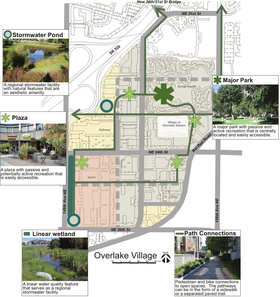
8 Redmond Overlake Master Plan and Implementation Strategy Open Space & Public Amenities Overlake benefits from having a number of quality open spaces within and in close proximity to the neighborhood, including Marymoor Park, Bridle Trails State Park, and the SR 520 Bike Path. Access and connections to these parks, however, need to be improved in order to better serve the residents and workers in Overlake. As the population of Overlake continues to grow, it will also be necessary to ensure that the number of parks and open spaces within the neighborhood s borders grow at a similar rate. Within Overlake Village, it will be especially important to add parks and open space. MAKERS architecture + urban design 29
9 OS-1 OS-2 Provide multi-modal connections to open spaces and recreational opportunities within and near the Overlake Neighborhood. In order for open spaces and recreational areas to be true amenities, they must be accessible to residents, workers, and visitors in Overlake. In particular, there should be connections, including trails, sidewalks, and bus routes, to: - Regional open spaces such as Bridle Trails State Park and Marymoor Park - Parks and recreational opportunities near Overlake Village. - Smaller scale open spaces in the residential area Trail connections could be provided in stream buffers where appropriate. Where sidewalks provide linkages between parks, open spaces and recreational opportunities, wayfinding should be improved to make these connections more navigable Encourage the use of native and drought resistant plants when designing plantings in open space to reduce irrigation requirements and conserve water. Plants native to the northwest are accustomed to this area s dry summers and wet winters and therefore require less watering in the summer. They also provide important habitat. Create a system of connected open spaces Overlake is close to several regional parks and recreation opportunities, including Marymoor Park and the SR 520 bike trail; however, the area lacks easy access to these amenities. Within the neighborhood, Overlake lacks a substantial community gathering place and Overlake Village does not include any parks and recreation areas within its borders. This severely diminishes the livability of this district and its appeal to future residents. The Master Plan addresses these issues by: Improving access to the surrounding regional parks and recreation amenities. Creating a variety of open spaces in Overlake Village as the area redevelops, designed to serve a number of purposes. Connecting the open spaces with a network of pedestrian connections. 30


10 Redmond Overlake Master Plan and Implementation Strategy OS-3 Encourage the use of bioretention features as a stormwater management technique and as an aesthetic amenity when designing open spaces. OS-4 Ensure quality of public and private open spaces. Maintain design standards for open spaces provided as part of private development to ensure that they are safe and meet public objectives. OS-5 Monitor the need for civic facilities such as a future community center that is accessible to the entire neighborhood. A community center could be an important community amenity that would help improve the livability of the entire neighborhood. When considering the potential for a community center, the City should consider including space for the relocation of the Overlake police substation or other needed City services. Rain gardens in open spaces can be an aesthetic amenity as well as a technique for stormwater management OS-6 Pursue opportunities to provide special use parks in the Employment Area, as identified in Redmond s PRO (Parks, Recreation and Open Space) Plan. OS-7 Support the development of private open spaces and recreation opportunities in the Employment Area. Work with businesses in the Employment Area to provide open space and recreational opportunities to employees. Large corporations with campuses in this area provide a unique opportunity to incorporate a variety of open spaces. A new community center could be an important community amenity for the Overlake Neighborhood. The term bioretention was created to describe an integrated stormwater management practice that uses the chemical, biological, and physical properties of plants, microbes, and soils to remove, or retain, pollutants from stormwater runoff. Puget Sound Action Team s Low Impact Development Technical Guidance Manual for Puget Sound. Bioretention areas are: Shallow landscaped depressions with a designed soil mix and plants adapted to the local climate and soil moisture conditions that receive stormwater from a small contributing area. Facilities designed to more closely mimic natural conditions, where healthy soil structure and vegetation promote the infiltration, storage, and slow release of stormwater flows Small-scale, dispersed facilities that are integrated into the site as a landscape amenity MAKERS architecture + urban design 31
11 32


12 Redmond Overlake Master Plan and Implementation Strategy OS-8 Coordinate new open spaces with new development in Overlake Village. A system of open spaces are proposed to be added throughout Overlake Village and connected by pedestrianfriendly landscaped sidewalks and multi-use pathways. It is important that these new open spaces relate to adjacent streets and surrounding buildings. While open spaces should be incorporated throughout Overlake Village as property develops, a few locations were identified specifically for park/open space improvements in conjunction with new Example of a major park development: - Incorporate a signature community open space in the redevelopment of the Group Health site. This is envisioned to be accessible from 152nd Avenue NE and located adjacent to active uses, such as retail and public facilities. The central location of the park combined with the proximity to mass transit will ensure that it is easily accessible to the entire neighborhood as well as surrounding areas. This major park would act as a central neighborhood gathering place through the provision of plazas, green spaces, and small play areas. Example of a small park - Incorporate an outdoor plaza as part of future redevelopment of the PS Business Park site. This plaza should be a place where people gather for passive social activities and potentially active play. It will be accessible from the 152nd corridor and will be located in close proximity to a high-capacity transit/light rail station and a Bus Rapid Transit stop. A water feature could be added to enhance the aesthetics of the park and as a play feature for children. - Incorporate a retail plaza as part of future Example of a retail plaza redevelopment of the Sears/Regency Center site. A pleasant gathering space, this plaza should be developed with adjacent active uses such as cafes or retail. The pedestrian-oriented plaza would be accessible from NE 24th Street. MAKERS architecture + urban design 33


13 OS-9 Develop regional stormwater facilities in Overlake Village. These facilities will treat stormwater from a larger portion of the Overlake Neighborhood. The goal of these facilities is to handle 70 percent of the stormwater runoff from all private parcels in Overlake Village and 100 percent of the runoff from the public right-of-ways, to avoid the need to detain and treat stormwater on a site-by-site basis. The proposed approach is one facility that combines flow control and water quality function in the form of a two to four acre wet pond in the northwest corner of Overlake Village. There is also a need for a large flow control facility in the form of a two to four acre stormwater pond in the southwest corner of the Village. This pond is envisioned to also act as a gateway to the neighborhood. A linear water quality feature in the form of a linear wetland is proposed to be located along the southern portion of 148 th Avenue NE. These stormwater facilities will look like natural features surrounded by vegetation and will become aesthetic amenities for the neighborhood. OS-10 Create a Low Impact Development (LID) incentive program for the Overlake Neighborhood. The Overlake incentive program can build upon the City-wide program which will be developed in the near future. LID techniques can be implemented on a site by site basis in the Overlake Neighborhood to decrease stormwater flow levels and to improve water quality. LID techniques include: - Vegetated (green) roofs - Rainwater roof harvesting - Bioretention cells (rain gardens) - Bioretention swales - Compost-amended filter strips Developers can be given incentives to incorporate LID features in developments. The incentives for developers could include: - Reduced permit review time - Public recognition - Flexibility in bulk, dimensional, and height restrictions - Reduction in stormwater system development fees 34
New Partners for Smart Growth Conference February 5, 2010
 Dan Stroh, Planning Director City of Bellevue Planning and Community Development Bellevue, WA New Partners for Smart Growth Conference February 5, 2010 Summary of Project Long-range plan update for Bel-Red
Gold Line Bus Rapid Transit Transit Oriented Development (BRTOD) Helmo Station Area Plan
 Helmo Station Area Plan") Appendix F Gold Line Bus Rapid Transit Transit Oriented Development (BRTOD) Helmo Station Area Plan Introduction and Purpose of the Plan The Gold Line Bus Rapid Transit facility is an eleven-mile dedicated
Appendix F Gold Line Bus Rapid Transit Transit Oriented Development (BRTOD) Helmo Station Area Plan Introduction and Purpose of the Plan The Gold Line Bus Rapid Transit facility is an eleven-mile dedicated
Description of Preferred Alternative
 Chapter 2 Description of Preferred Alternative 2.1 Introduction This chapter of the programmatic Sammamish Town Center Sub-area Plan Final EIS provides a more detailed description of the Preferred Alternative
Issues Requiring Future Study
 Issues Requiring Future Study Transportation planning is an ongoing process that tends to identify new issues as it finds solutions for others. Some issues are so complex that a solution to one problem
The University District envisions, in its neighborhood
 Envisioning the University District Link Light Rail in Seattle s neighborhoods CIY OF SEALE CONCEP-LEVEL SAION AREA PLANNING RECOMMENDAION RESOLUION # 30165 EXHIBI L Vision 08.2000 he University District
Potential Green Infrastructure Strategies May 6, 2015 Workshop
 Potential Green Infrastructure Strategies May 6, 2015 Workshop Background The City of Cortland is developing the Tioughnioga Urban Headwaters Green Infrastructure Action Plan with funding from the National
Silverdale Regional Center
 Silverdale Regional Center Vision for Silverdale Regional Center The Silverdale Regional Center Plan (Plan) will guide the evolution of the Silverdale Regional Center from a collection of strip malls and
CHAPTER 7: Transportation, Mobility and Circulation
 AGLE AREA COMMUNITY Plan CHAPTER 7 CHAPTER 7: Transportation, Mobility and Circulation Transportation, Mobility and Circulation The purpose of the Transportation, Mobility and Circulation Chapter is to
Northwest Rail Corridor and US 36 BRT Development Oriented Transit Analysis 4.4 STATION AREA FINDINGS
 4.4 STATION AREA FINDINGS Each station is different, and each one requires a separate set of recommendations based on the vision for the site. This section outlines an initial TOD strategy and recommendations
hermitage town center
 hermitage town center A Community Vision prepared by Strada for The City of Hermitage and The Mercer County Regional Planning Commission January 2007 table of contents introduction 3 design principles
Town Center. Block 5 Existing multifamily residential units are expected to remain.
 Area Guidelines Germantown s districts should be developed as distinct communities with unique features that are supported through the guidelines. The guidelines not only help distinguish these districts
Chapter 4. Linking Land Use with Transportation. Chapter 4
 Chapter 4 Linking Land Use with Transportation Chapter 4 59 Chapter 4 Linking Land Use with Transportation Community Design and Transportation Program Introduction Since the 1950s, the predominant development
Subregion 4 Central Avenue-Metro Blue Line Corridor Transit-Oriented Development (TOD) Implementation Project. Community Meeting April 27, 2011
 Implementation Project. Community Meeting April 27, 2011") Subregion 4 Central Avenue-Metro Blue Line Corridor Transit-Oriented Development (TOD) Implementation Project Community Meeting April 27, 2011 Overview Introduction to Subregion 4 TOD Implementation Program
Subregion 4 Central Avenue-Metro Blue Line Corridor Transit-Oriented Development (TOD) Implementation Project Community Meeting April 27, 2011 Overview Introduction to Subregion 4 TOD Implementation Program
Town Center (part of the Comprehensive Plan)
") Town Center (part of the Comprehensive Plan) Mercer Island Town Center Looking North (2014) In 1994, a year-long process culminated in a set of design guidelines and code requirements for the Town Center
Town Center (part of the Comprehensive Plan) Mercer Island Town Center Looking North (2014) In 1994, a year-long process culminated in a set of design guidelines and code requirements for the Town Center
Neighborhood Districts
 NEIGHBORHOOD DISTRICTS SEVEN MAIN DISTRICTS Neighborhood Districts While the Development Plan provides a broad-scale overview of the neighborhood, this section focuses on uses and relationships at the
Plano Tomorrow Vision and Policies
 Plano Tomorrow Vision and Policies PLANO TOMORROW PILLARS The Built Environment The Social Environment The Natural Environment The Economic Environment Land Use and Urban Design Transportation Housing
EXISTING COMPREHENSIVE PLAN
 EXISTING COMPREHENSIVE PLAN Town Center Land Use Element: V. LAND USE POLICIES Town Center Mercer Island's business district vision as described in "Your Mercer Island Citizen-Designed Downtown" was an
The West Vaughan Employment Area Secondary Plan Policies
 Part 2: The West Vaughan Employment Area Secondary Plan Policies 2.1 General Policies It is the policy of Council: 2.1.1. That the West Vaughan Employment Area (the WVEA), identified on Schedule 1, will
WELCOME and introduction
 1 WELCOME and introduction Mobility Hub Locations within Burlington STUDY OVERVIEW STUDY OBJECTIVES The City of Burlington is developing four Area Specific Plans, one for each of Burlington s Mobility
Study Area. Capitol Way. Greening America s Capitals 11/13/2014. A Greening America s Capitals Project
 Olympia, WA: Greening Capitol Way Supporting Communities move towards sustainability is a priority for the federal government. A Greening America s Capitals Project Office of Sustainable Communities U.S.
Northwest commuter rail station US 36 BRT. Westminster Station
 Northwest commuter rail station Westminster Station US 36 BRT Westminster Center US 36 & Church Ranch Broomfield Flatiron/96 th St. US 36 & McCaslin Table Mesa Boulder Junction 13-month effort that will
Ten Mile Creek Planning Area
 PLANNING AREA POLICIES TEN MILE CREEK Ten Mile Creek Planning Area Location and Context The Ten Mile Creek Planning Area ( Ten Mile Creek area ) is located south of the current Boise AOCI, generally south
1 Adapted from the Statewide Transit-Oriented Development Study by CalTrans, 2006
 APPENDIX C: LAND USE PLANNING FOR ENHANCED RAIL SERVICE 72 BACKGROUND One of the consistent themes heard from localities in the Route 29 corridor Planning Forums was the need for expanding rail service
Establish a network of streetscaped vehicle and pedestrian routes that connect within and outside the Plan area.
 This Plan s urban design goals are to create an urban scale, walkable community with connections to transit, parks, and services and with amenities and facilities for residents and employees. The 1992
ELMVALE ACRES SHOPPING CENTRE MASTER PLAN
 ELMVALE ACRES SHOPPING CENTRE MASTER PLAN Contents 1.0 INTRODUCTION... 2 2.0 LOCATION... 2 3.0 EXISTING CONTEXT... 2 4.0 VISION & GUIDING PRINCIPLES... 2 5.0 LAND USE AND BUILT FORM... 4 5.1 St. Laurent
Seneca Meadows. Block 4 Locate office, technology, and medical development adjacent to I Screen views of garage structures from I-270.
 Seneca Meadows Seneca Meadows has an industrial park in its southern end and a mixed-use employment area planned for the north end. The district benefits from extensive I-270 visibility, stream valley
Draft Bergamot Area Plan
 ATTACHMENT 1 Draft Bergamot Area Plan Taskforce on the Environment April 15, 2013 www.bergamotplan.net 1 Overview WHAT IS THE BERGAMOT AREA PLAN? A Community-Based Planning Document Guiding the Future
FUTURE LAND USE ELEMENT
 FUTURE LAND USE ELEMENT GOAL I: To create and sustain a great place to live, play, and prosper Objective 1: The City of Ocala shall incorporate the principles and strategies of the Ocala 2035 Vision into
COMPLETE GREEN STREET CHECKLIST
 COMPLETE GREEN STREET CHECKLIST This document was developed to dissect the structure of an urban street and explore opportunities to make our streets more complete while also integrating green street strategies.
TRANSPORTATION ELEMENT GOALS, OBJECTIVES, AND POLICIES
 TRANSPORTATION ELEMENT GOALS, OBJECTIVES, AND POLICIES GOAL 2 The City shall provide a safe, convenient, effective, and energy efficient multimodal transportation system which is coordinated with the Future
MONTGOMERY COUNTY METRO STATION AREA DESIGN CHARRETTE
 MONTGOMERY COUNTY METRO STATION AREA DESIGN CHARRETTE Shady Grove Metro Station Area Charrette Closing Presentation October 25-28, 2000 MONTGOMERY COUNTY, MD M-NCPPC Design Collective, Inc. Architects
Courthouse Square Planning & Urban Design Study. Courthouse Square Working Group #13 October 15, 2014
 Courthouse Square Planning & Urban Design Study Courthouse Square Working Group #13 October 15, 2014 1 Courthouse Square Process Working Group Community Courthouse Square Advisory Groups & Civic Associations
Clair-Maltby Community visioning
 Clair-Maltby Community visioning workshop #1 Summary April 27th, 2017 Table of Contents INTRODUCTIon 1 PURPOSE 1 CONSULTATION STRUCTURE 2 PARTICIPANT FEEDBACK 3 VISIONING EXERCISE 8 ONLINE SURVEY RESULTS
South Davis County COMMUNITY SPOTLIGHT
 South Davis County COMMUNITY SPOTLIGHT Davis/SLC Community Connector Bus Rapid Transit line connecting SLC & Davis County RTP Phase 1 Project Generate 3,100 average weekday riders Relieve congestion on
Today Land & People. Northeast Nampa Gateway District. Employment. Land Use Characteristics. Demographics. Current Zoning
 Today Land & People Employment Major employers include Saint Alphonsus, the College of Western Idaho, the Auto Mall, Sorrento Lactalis and Walmart. 3,004 jobs in 2010 (COMPASS-CIM 2040 TAZ data) 4,345
include playgrounds, sports fields, community gardens and picnic areas.
 DEVELOPMENT PLAN OPEN SPACE SYSTEM OPEN SPACE SYSTEM The neighborhood provides for a range of open space types. The Village Square is an important open space in the neighborhood. It serves as a gathering
McCowan Precinct Plan Study Background & Deliverables
 1 DRAFT & WITHOUT PREJUDICE McCowan Precinct Plan Study Background & Deliverables In September, 2011, City Planning (Scarborough District) began a study of an area within the Scarborough Centre, identified
Executive Summary. NY 7 / NY 2 Corridor
 Executive Summary NY 7 / NY 2 Corridor Transportation and Land Use Study December 2005 Prepared for: Town of Colonie Capital District Transportation Committee Prepared by: Introduction: Land use decisions
A. WHAT IS A GENERAL PLAN?
 I. Introduction A. WHAT IS A GENERAL PLAN? A general plan is the planning guideline for the future of a city. It contains goals and policies which regulate urban development, the protection of the natural
ROBBINSDALE LRT STATION CDI DEVELOPMENT GUIDELINES
 August 2018 OVERVIEW The City of Robbinsdale has a prime-opportunity site in the middle of the 13 mile stretch of the Bottineau LRT corridor / Blue Line extension. Robbinsdale offers a prominent, vital,
Preliminary Recommendations Tk Takoma/Langley Crossroads Sector Plan
 Preliminary Recommendations Tk Takoma/Langley Crossroads Sector Plan Vision is to achieve a Transit Oriented, pedestrian friendly Community that Celebrates and builds upon the cultural Diversity of the
Chapter 1: Introduction
 Chapter 1: Introduction The Penn Avenue Community Works Corridor Vision and Implementation Framework presents an integrated communitybased vision and a coordinated, long-term implementation framework for
RESOLUTION NO. R Refining the route, profile and stations for the Downtown Redmond Link Extension
 RESOLUTION NO. R2018-32 Refining the route, profile and stations for the Downtown Redmond Link Extension MEETING: DATE: TYPE OF ACTION: STAFF CONTACT: Capital Committee Board PROPOSED ACTION 09/13/2018
public review draft Key objectives for this chapter are:
 5 - parks & open space Providing a rich collection of outdoor places for informal gathering and recreation, as well as planned promotional activities and community events, is a key concept for Midtown.
ATTACHMENT A. SILVERDALE DESIGN STANDARDS Amendments to the Waaga Way Town Center Chapter
 ATTACHMENT A SILVERDALE DESIGN STANDARDS Amendments to the Waaga Way Town Center Chapter Chapter 10. Waaga Way Town Center 10.1 Physical Identity Elements & Opportunities The Waaga Way Town Center includes
Policies and Code Intent Sections Related to Town Center
 Policies and Code Intent Sections Related to Town Center The Town Center Vision is scattered throughout the Comprehensive Plan, development code and the 1994 Town Center Plan. What follows are sections
Complete Neighbourhood Guidelines Review Tool
 Complete Neighbourhood Guidelines Review Tool Prepared By: City of Regina Planning Department October 2014 Page 1 of 14 Community Development Review Checklist for Secondary Plans and Concept Plans The
A BLUEPRINT FOR BROCKTON A CITY-WIDE COMPREHENSIVE PLAN
 A BLUEPRINT FOR BROCKTON A CITY-WIDE COMPREHENSIVE PLAN Public Meeting October 2016 1 Plan Summary and Discussion Public Meeting May 4 2017 City of Brockton Bill Carpenter, Mayor Department of Planning
THE 355/270 CORRIDOR:
 THE 355/270 CORRIDOR: Strategic Ideas for Sustaining a Livable Work Place Project Summary ACCESS LIFE DESIGN HEALTH WORK Montgomery County Planning Department The Maryland-National Capital Park and Planning
Hopkins. Development Guidelines May Overview. Sponsored by: Blake Road Corridor Collaborative City of Hopkins
 Hopkins Blake Road LRT Station Area Development Guidelines May 2015 Sponsored by: Blake Road Corridor Collaborative City of Hopkins Overview Hopkins is a dynamic community of over 17,000 residents located
Hockessin Community Redevelopment Plan
 Hockessin Community Redevelopment Plan 3.1 Introduction The Community Redevelopment Plan for the Village of Hockessin is the result of the people s vision for a distinct village center that serves as the
Robbinsdale LRT Station. CDI Development Guidelines. August Overview
 Robbinsdale LRT Station August 2018 Overview The City of Robbinsdale may have the coolest opportunity site along the 13 mile stretch of the Bottineau LRT corridor / Blue Line extension. Located a block
Corridor Vision. 1Pursue Minnehaha-Hiawatha Community Works Project. Mission of Hennepin County Community Works Program
 1Pursue Minnehaha-Hiawatha Community Works Project Minnehaha-Hiawatha Community Works is a project within the Hennepin Community Works (HCW) program. The mission of the HCW program is to enhance how the
17.11 Establishment of Land Use Districts
 17.11 Establishment of Land Use Districts 17.11.010 Purpose. To promote the health, safety, and general welfare of City residents and those who come to South Salt Lake to work, exchange commerce and recreate.
38 Queen s University Campus Master Plan Part 1
 38 Queen s University Campus Master Plan Part 1 46 The Campus at the City Scale Chapter 4 The Campus at the City Scale 39 Queen s is an urban University centrally located in Kingston. Decisions made by
3. ELEMENTS OF THE METRO VISION 2035 PLAN
 3. ELEMENTS OF THE METRO VISION 2035 PLAN What is Metro Vision and why does it matter? For more than 50 years, DRCOG has championed a regional perspective on key issues facing the metropolitan area and
SPRINGHILL LAKE TRANSIT VILLAGE
 Greenbelt Metro Area Sector Plan - Subarea Design Policies and Guidelines - Springhill Lake Transit Village 113 SPRINGHILL LAKE TRANSIT VILLAGE Residential Neighborhood and Village Center CONCEPT Springhill
Strategic Growth Area #1 Northampton Boulevard Corridor Area
 Strategic Growth Area #1 Northampton Boulevard Corridor Area Description Strategic Growth Area #1 has established itself as a major employment center in Southside Hampton Roads. Opportunities exist to
West Ocala Vision & Community Plan City Council Work Session. Presented by West Ocala Community Plan Steering Committee
 West Ocala Vision & Community Plan City Council Work Session Presented by West Ocala Community Plan Steering Committee November 29,2011 Ocala 2035 Vision West Ocala Community Vision & Master Plan West
The transportation system in a community is an
 7 TRANSPORTATION The transportation system in a community is an important factor contributing to the quality of life of the residents. Without a sound transportation system to bring both goods and patrons
LAND USE ELEMENT. Purpose. General Goals & Policies
 LAND USE ELEMENT Purpose This Land Use Element contains the goals and policies necessary to support the City s responsibility for managing land resources and guiding development through implementing regulations,
Seattle s Natural Drainage Systems and Complete Streets
 Seattle s Natural Drainage Systems and Complete Streets NACTO Designing Cities 2016 Outline Set stage Seattle and systems How Seattle has utilized bioretention to protect water systems Pathways for project
Proposed Comprehensive Plan Strategies DRAFT for discussion June 28, 2017
 Proposed Comprehensive Plan Strategies DRAFT for discussion June 28, 2017 Land Use Rural Areas Refine the Farm and Forest area (FF) Update FF boundaries to account for existing lots less than five acres
Whitemarsh Comprehensive Plan Update: Housing & Land Use. Public Workshop #3: September 20, 2018
 Whitemarsh Comprehensive Plan Update: Housing & Land Use Public Workshop #3: September 20, 2018 Agenda Welcome Process Recap What We ve Heard The Plan Framework Review of Recommended Actions Land Use Housing
2.0 THE PLATINUM TRIANGLE VISION
 2.0 THE PLATINUM TRIANGLE VISION The envisions an exciting future for the area surrounding Angel Stadium of Anaheim, the Honda Center and The Grove of Anaheim. 2.1 Planning Principles In order to further
9/19/2018 TODAY S WEBINAR AGENDA CONTINUING EDUCATION UPCOMING TRAINING FROM APBP
 TODAY S WEBINAR AGENDA 3:00 pm: Introduction 3:05 pm: Presentation 3:45 pm: Questions 4:00 pm: Webinar Ends For technical assistance during the webinar: 1-800-263-6317 Choose these prompts: 1, 1, 1 CONTINUING
The Vision. Photo provided by The Minervini Group. 46 Vision, Objectives & Strategies
 Vision, Objectives & Strategies The is the public framework and guide for future development of the Grand Traverse Commons. The establishes public polices for infrastructure, the preservation of natural
The Lincoln Neighborhood Corridor Plan. The LiNC
 October 1, 2014 Planning Commission Study Session The Lincoln Neighborhood Corridor Plan The LiNC Purpose of Tonight s Meeting Introduction to The LiNC Review of Existing Conditions and Community Identified
DRAFT ROOSEVELT ROAD. District Recommendations. Figure 5.23 The Roosevelt Road Corridor
 CHAPTER 5 Figure 5.23 The Road Corridor Road will develop as a mixed-use corridor, emphasizing regional retail, west of the river and mixed-use development east of the river. KEY RECOMMENDATIONS 1. High
ANCHOR TO ANCHOR. Rescale the street to create an iconic boulevard.
 ANCHOR TO ANCHOR Rescale the street to create an iconic boulevard. UR NE ER UV GO NE LA OBJECTIVES 1. Maintain appropriate traffic flow and prioritize commercial curb access 2. Mark gateways at the street
REVIEW AND EVALUATION OF REGIONAL LAND USE
 REVIEW AND EVALUATION OF REGIONAL LAND USE AND TRANSPORTATION SCENARIOS #220831 Environmental Justice Task Force October 7, 2014 VISION 2050 Process Development of Guiding Vision for Land Use and Transportation
SQUAMISH 2010 AND BEYOND COMMUNITY VISION
 Our plan has been imagined and created to be both pragmatic and visionary. At the core of the strategy is a consideration of the highway s role and its impact on the community. First and foremost in creating
Toronto Complete Streets Guidelines
 Toronto Complete Streets Guidelines 108 110 7.1 Green Infrastructure Design Principles 112 7.2 Context-Sensitive Green Streets 114 7.3 Key Green Street Elements Green infrastructure refers to natural and
City of Hermosa Beach Administrative Policy #
 City of Hermosa Beach Administrative Policy # SUBJECT: Living Streets Policy Date: Approved by: City Council Authority: Public Works Department & Community Development Department Mayor, PURPOSE The City
Lower Merion Commercial Districts Issues and Characteristics Handbook November 2013
 Lower Merion Commercial Districts Issues and Characteristics Handbook November 2013 DRAFT TOWNSHIP-WIDE VISION: To maintain and enhance commercial areas to complement the surrounding high-quality residential
C. Westerly Creek Village & The Montview Corridor
 C. Westerly Creek Village & The VISION Community Vision When the goals of the city are achieved Westerly Creek Village, a distinctive community defined by Montview Boulevard and Westerly Creek, is a strong
greenprint midtown SUSTAINABILITY ACTION PLAN 2012
 greenprint midtown SUSTAINABILITY ACTION PLAN 2012 MIDTOWN ALLIANCE SOUTHFACE ENERGY INSTITUTE RENAISSANCE PLANNING GROUP SUSTAINABLE ATLANTA PERKINS+WILL 2 GREENPRINT MIDTOWN 1. Introduction Sustainability
BROOKHILL NEIGHBORHOOD MODEL ZONING MAP AMENDMENT PREFACE TO APPLICATION
 BROOKHILL NEIGHBORHOOD MODEL ZONING MAP AMENDMENT PREFACE TO APPLICATION June 15, 2015 Revised: August 1, 2016 I. VISION Brookhill is a proposed community based upon the principles of Albemarle County
REGIONAL ACTIVITY CENTER
 DRAFT REGIONAL ACTIVITY CENTER 70 EAST BENCH MASTER PLAN DRAFT 06 Introduction The East Bench Regional Activity center is comprised of large educational, research, medical, and employment centers. These
Green Gables. April 24, 2013
 Green Gables Preliminary and Final Plat April 24, 2013 Development Team Green Gables Development Corporation (Owner/Developer) DTJ Design (Planner/Landscape Architect) Enertia Consulting Group (Civil Engineer)
Table of Contents. Elm Avenue Improvement Plan City of Waco, Texas. Introduction 1. Existing Context 1 Figure 1 2.
 Table of Contents Introduction 1 Existing Context 1 Figure 1 2 Plan Guidelines 3 Future Urban Form 4 The West-End 4 Main Street 6 The East-End 7 Figure 2 9 Public Improvement Recommendations 7 General
REQUEST Current Zoning: O-15(CD) (office) Proposed Zoning: TOD-M(CD) (transit oriented development mixed-use, conditional)
 (office) Proposed Zoning: TOD-M(CD) (transit oriented development mixed-use, conditional)") Rezoning Petition 2016-117 Zoning Committee Recommendation January 4, 2017 REQUEST Current Zoning: O-15(CD) (office) Proposed Zoning: TOD-M(CD) (transit oriented development mixed-use, conditional) LOCATION
Rezoning Petition 2016-117 Zoning Committee Recommendation January 4, 2017 REQUEST Current Zoning: O-15(CD) (office) Proposed Zoning: TOD-M(CD) (transit oriented development mixed-use, conditional) LOCATION
Date: April 10, 2017 City Council Work Session April 24, 2017: Status Report on the Comprehensive Plan Update and Transportation Master Plan
 AGENDA REPORT To: From: By: Honorable Mayor and City Council Members Warren Hutmacher, City Manager Sharon Ebert, Director Community Development Date: April 10, 2017 Agenda: City Council Work Session April
4 LAND USE DESIGNATIONS
 4 LAND USE DESIGNATIONS Chapter 4 describes the land use designations and densities that will implement the development vision for North Burlingame outlined in Chapter 3. Land use densities are described
V. Vision and Guiding Principles
 V. Vision and Guiding Principles The Master Plan for the Powers Ferry Corridor seeks a foundation in the desires of the community. At times, various elements of the community offered opposing viewpoints,
Clairtrell Area Context Plan
 Clairtrell Area Context Plan March 2005 Urban Development Services City Planning Contents 1. Introduction... 4 2. Development Structure... 6 2.1 Streets... 7 2.1.1 Sheppard Avenue and Bayview Avenue...
8implementation. strategies
 PROGRAM STRATEGIES 8implementation strategies T he implementation actions of this chapter are designed to support and carry out the land use, economic development, transportation, urban design, and program
Stakeholders Advisory Working Groups (SAWGs) Smart Growth and TOD Land Use (#11) SAWG Meeting
 Smart Growth and TOD Land Use (#11) SAWG Meeting") Presentation - Part II Tappan Zee Bridge/I-287 Corridor Project July 21, 2010 Slide 1. David Kooris (Regional Plan Association) welcomed members of the Land Use Stakeholders Advisory Working Groups (SAWGs)
Presentation - Part II Tappan Zee Bridge/I-287 Corridor Project July 21, 2010 Slide 1. David Kooris (Regional Plan Association) welcomed members of the Land Use Stakeholders Advisory Working Groups (SAWGs)
4. INDUSTRIAL 53 CASTLE ROCK DESIGN
 4. INDUSTRIAL 53 CASTLE ROCK DESIGN CASTLE ROCK DESIGN 54 4. INDUSTRIAL Overview Well-designed and attractive industrial centers are the product of blending economic realities with both functional and
CHAPTER SEVEN CITY CENTER
 CHAPTER SEVEN CITY CENTER 7.0 INTRODUCTION 1 Purposes 1 7.1 POLICY BACKGROUND 2 Growth Management Act 2 VISION 2040 2 Countywide Planning Policies 3 7.2 THE ROLE OF THE CITY CENTER IN FEDERAL WAY S FUTURE
TRANSPORTATION PROJECTS
 TRANSPORTATION PROJECTS 40 BUFFALO S LWRP PROPOSED PROJECTS T1. Niagara Street/Great Lakes Seaway Trail Streetscape Project City of Buffalo Department of Public Works Niagara Street from Niagara Square
1.0 Circulation Element
 5/9/18 1.0 Circulation Element 1.1 Introduction As growth and development occur in Apache County, enhancements to its circulation system will be necessary. With time, more roads will be paved and air and
Clovis Urban Greening Plan. Community Workshop #2 Northwest
 Clovis Urban Greening Plan Community Workshop #2 Northwest Thursday, October 9, 2014 WHAT IS AN URBAN GREENING PLAN? A guide to help the City to improve quality of life for residents Identification of
Illustration of Eastlake Farmer s Cooperative Grain Elevator. Chapter 5: implementation 5-1
 Illustration of Eastlake Farmer s Cooperative Grain Elevator Chapter 5: implementation 5-1 chapter 5: implementation Introduction The Eastlake Subarea Plan includes a wide range of recommendations intended
3.1 community vision. 3.3 required plan elements
 Chapter 3 Community Form 3.1 community vision 3.2 Parks & landscaping concepts 3.3 required plan elements D R A F T 20 Community Form Chapter 3 3.0 Community form 3.1 community vision The Specific Plan
HILLSBOROUGH COUNTY Greenways and Trails Plan Update. Executive Summary. Date
 HILLSBOROUGH COUNTY Greenways and Trails Plan Update Executive Summary Date PURPOSE AND PROJECT OVERVIEW The Hillsborough County Greenways Master Plan (1995) and the City of Tampa s Greenways and Trails
Germantown Forward Status Report to the Planning Board M NCPPC
 Germantown Forward Status Report to the Planning Board Germantown Forward March 27, 2008 What s new? CCT alignment Capital Improvement Program Agency partners Water quality conditions Sustainability Design
Riverwalk Dreams compiled by Thomas P. Healy November 16, 2017
 Riverwalk Dreams compiled by Thomas P. Healy November 16, 2017 1986 Ripple Village Plan: A neighborhood plan developed by the City of Indianapolis Department of Metropolitan Development s Division of Planning
THE NEIGHBORHOOD TODAY
 THE NEIGHBORHOOD TODAY CORE AREA VISION How are we Good Urbanism A Site s DNA thinking about Elements of great Unique elements urban communities embedded in a place the site and design? ELEMENTS LIKE:
Rio/29 Small Area Plan. Design Plan & Implementation Framework Open House - January 25, 2018
 Rio/29 Small Area Plan Design Plan & Implementation Framework Open House - January 25, 2018 MEETING PURPOSE PRESENTATION 1. Orient to the updated design plans 2. Introduce implementing options 3. Explain