LANDMARK CENTER BOSTON CIVIC DESIGN COMMISSION OCTOBER 1, 2013
|
|
|
- Bryan Stokes
- 6 years ago
- Views:
Transcription

1 BOSTON CIVIC DESIGN COMMISSION OCTOBER 1, 2013
2 CONTENTS 01 PROJECT SUMMARY 03 PROGRAMMING & URBAN DESIGN 02 PROJECT SITE 04 AERIAL VIEW 05 EMERALD NECKLACE 06 SITE PLAN 07 EXISTING PHOTOS 03 FLOOR PLANS 08 GROUND 09 PARKING 10 SECOND 11 THIRD 12 TWELFTH 13 ROOF 04 SECTION & ELEVATIONS 14 SECTION EAST-WEST 15 ELEVATION PARK DRIVE 16 ELEVATION FULLERTON STREET 17 ELEVATION MULTI-USE PATH 18 ELEVATION BROOKLINE AVENUE 05 RENDERINGS 19 FENWAY MARKET 20 FROM THE RIVERWAY
3 3 PROJECT SUMMARY The proposal at Landmark Center in the Fenway entails the re planning and redevelopment of the existing Landmark Center located at the corner of Park Drive and Brookline Avenue adjacent to the Sear s Rotary in Boston s Fenway neighborhood, proposed by Fenway Enterprises LLC, a Samuels & Associates entity, on behalf of Landmark Center Ventures LLC. 75,000 gsf grocery store. An additional 15,000 gsf of office to the existing 675,000 gsf of office. A new public plaza along Brookline Avenue and Fullerton Street. MASSING & DESIGN Building massing has been shaped in response to the height and use of the surrounding context and the desire to preserve daylight and views both on- and off-site. The removal of almost 380,000 square feet of existing above-grade garage offsets the impact of new massing on the Project Site. The 01 PROJECT SUMMARY The entire site is being re planned to make the historic Sears building and the surrounding block more permeable. The strategies are dramatic and include the demolition of all above grade parking, creation of new public space on Brookline Avenue and the relocation of the office lobbies to the street level. Redevelopment of the Project Site will bring new ground and second floor retail uses, including a major supermarket. The interior of the Landmark Center will be reconfigured to provide weather protected travel from the Fenway MBTA station to the commercial district of the Fenway neighborhood, through a destination food market anchored on the Fullerton side of the building by the new supermarket. Above the retail, new residential buildings will be constructed. The Project also includes reconfiguration of a portion of existing office and cinema space, mechanical space, residential amenity space and other accessory uses and facilities. THE PROPOSED PROJECT CONSISTS OF : Increase in useable open space by 97 percent site wide to 2.2 acres. Preservation of the landmark status of the existing historic building. ZONING The Project Site is located in the Brookline Avenue Community Commercial Subdistrict of the Fenway Neighborhood District pursuant to Article 66 of the Boston Zoning Code. The Project Site is within the Restricted Parking Overlay District (RPOD) and the Groundwater Conservation Overlay District (GCOD). A portion of the Project Site along Park Drive is located in the Fenway/ Park Drive Greenbelt Protection Overlay District (GPOD). The existing improvements on the Project Site were approved by the BRA as a Chapter 121A project on December 15, 1996 by a Report and Decision (the Existing 121A Approval ) that included zoning deviations. The Proponent intends two-story base of the development is made up of a mix of small, intermediate and anchor scale retail designed to draw pedestrians to and through the Project Site from the MBTA, Park Drive, Brookline Avenue and Fullerton Street. Building masses above the retail base are oriented perpendicular to Brookline Avenue and Park Drive to maximize light and air around the proposed development. Building height decreases from south to north, stepping down toward the Audubon Circle neighborhood. The roof space between new and existing buildings above the retail base creates a unique opportunity for multi-level open space that is activated by both the commercial and residential uses. Materials and architectural expression carried down from the building mass to the street level accentuate the massing composition. A modern architectural expression is proposed and responds to the existing context and to the orientation of new buildings. The proposed buildings will stand alongside recent and new Removal of 380,000 sf of existing above-grade to seek 121A in connection with the Project. Because the development at Trilogy, 1330 Boylston Street, The Van Ness parking garage. proposed building exceeds 50,000 square feet, the Project and The Point, and will express their own unique identity Approximately 1,500 new parking spaces below grade. is subject to the requirements of Large Project Review pursuant to Article 80 of the Code. Since the proposed amid the continued positive growth of this neighborhood. Up to 550 new residential units. building also exceeds 100,000 square feet, the Project is An additional 110,000 gsf of retail to the existing 276,00 gsf retail. subject to schematic design review by the Boston Civic Design Commission (BCDC) under Article 28 of the Code.

4 4 02 PROJECT SITE AERIAL VIEW


5 5 COMMONWEALTH AVENUE PRUDENTIAL CENTER 02 PROJECT SITE SYMPHONY HALL MUSEUM OF FINE ARTS KENMORE SQUARE FENWAY PARK BOYLSTON STREET BROOKLINE AVENUE BOSTON UNIVERSITY ISABELLA STEWART GARDNER MUSEUM LANDMARK CENTER ON THE EMERALD NECKLACE

6 BEACON STREET 6 KENMORE EXISTING TO REMAIN RETAIL 02 PROJECT SITE CINEMA/ENTERTAINMENT OFFICE RESIDENTIAL SERVICE/PARKING HOTEL NE HEALTH CARE WB UR VE EA IN KL OO TAIL R B RE 20 YS TR E ET 1 ED OS OP IL PR RETA ED OS OP IL PR RETA N IN CE T EN IO ID ARR S RE Y M B ED OS OP IL PR RETA BR O OK N LI E A VE LA E NU ED OS OP IL PR RETA D AR RV ARD HA GU N A V ND SD OW NE STR EET FENWAY PARK E LIN OK IL RO TA 0 B RE 12 AVE E DR TL IPO K PA R IL NA PS LON SA M EL ST WE K& AC S EM LIO BO CVS SUBWAY PILLIPO CITIBANK TASTY BURGER GUITAR CENTER JERRY REMY S RITE AID FEDEX KINKOS BERRY LINE SWEET CHEEKS THE POINT RETAIL HOWARD JOHNSON HOTEL SW H S ET IPSWICH STREET IVE E LIN OK IL RO TA 6 B RE 12 AVE E LIN OK L RO TAI 2 B RE 13 AVE CH IP VAN NESS STREET IC E TR BOYLSTON STREET DOMINO S CHICKEN BONE BASEBALL TAVERN CITIZEN UPPER CRUST BASHO L AN D MARK CENTER BURGER KING SHAW S LOCATION & PRESENCE S A M U E L S & A S S O C I AT E S E L K U S M A N FR E D I A R C H I T EC T S


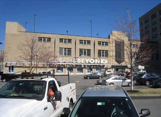
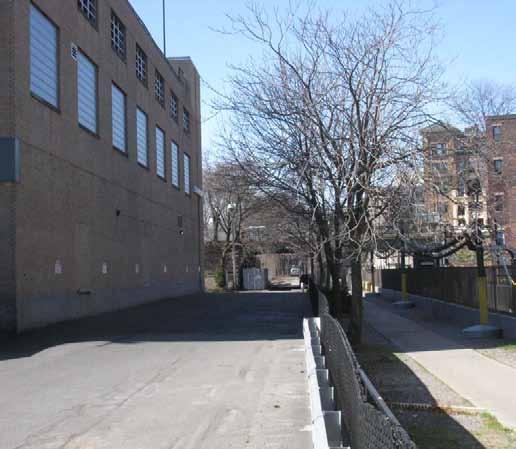
7 7 02 PROJECT SITE LANDMARK PHOTOS

8 8 MINER STREET 02 PROJECT SITE RIVERWAY RIVERWAY CONNECTOR PARK DRIVE FULLERTON STREET HARVARD VANGUARD BURLINGTON STREET EXISTING TO REMAIN RETAIL CINEMA OFFICE RESIDENTIAL SERVICE/PARKING BROOKLINE AVENUE GROUND FLOOR PLAN

9 9 03 FLOOR PLANS EXISTING TO REMAIN RETAIL CINEMA OFFICE RESIDENTIAL SERVICE/PARKING PARKING PLAN
10 10 03 FLOOR PLANS EXISTING TO REMAIN RETAIL CINEMA OFFICE RESIDENTIAL SERVICE/PARKING SECOND FLOOR PLAN

11 11 03 FLOOR PLANS EXISTING TO REMAIN RETAIL CINEMA OFFICE RESIDENTIAL SERVICE/PARKING THIRD FLOOR PLAN
12 12 03 FLOOR PLANS EXISTING TO REMAIN RETAIL CINEMA OFFICE RESIDENTIAL SERVICE/PARKING TWELFTH FLOOR PLAN
13 13 MINER STREET 03 FLOOR PLANS RIVERWAY RIVERWAY CONNECTOR PARK DRIVE FULLERTON STREET HARVARD VANGUARD BURLINGTON STREET EXISTING TO REMAIN RETAIL CINEMA OFFICE RESIDENTIAL SERVICE/PARKING BROOKLINE AVENUE ROOF PLAN

14 14 EXISTING TO REMAIN RETAIL CINEMA OFFICE RESIDENTIAL SERVICE/PARKING 04 SECTION & ELEVATIONS MARKET ARCADE PARK DRIVE PLAZA EXISTING FULLERTON STREET PROPOSED EAST-WEST SECTION

15 15 04 SECTION & ELEVATIONS ELEVATION PARK AVENUE

16 16 04 SECTION & ELEVATIONS ELEVATION FULLERTON STREET

17 17 04 SECTION & ELEVATIONS ELEVATION MULTI-USE PATH

18 18 04 SECTION & ELEVATIONS ELEVATION BROOKLINE AVENUE

19 19 05 RENDERINGS FENWAY MARKET

20 20 05 RENDERINGS FROM THE RIVERWAY
Residential Commons at Barry s Corner. Boston civic design commission February 5, 2013
 Residential Commons at Barry s Corner Boston civic design commission February 5, 2013 TABLE OF CONTENTS project summary 3 PROJECT site 4 PLANNING APPROACh 6 Parcel Diagams 6 Design Principles 8 Street
AMENDED AND RESTATED DEVELOPMENT PLAN FOR THE SPORTS FACILITY PROJECT WITHIN PLANNED DEVELOPMENT AREA NO. 87 BOSTON LANDING
 AMENDED AND RESTATED DEVELOPMENT PLAN FOR THE SPORTS FACILITY PROJECT WITHIN PLANNED DEVELOPMENT AREA NO. 87 BOSTON LANDING GUEST STREET, LIFE STREET AND ARTHUR STREET BRIGHTON AREA OF BOSTON DATED: August
1617TREMONT.COM REDEVELOPMENT OPPORTUNITY LONGWOOD MEDICAL AREA // MISSION HILL BOSTON, MASSACHUSETTS DOWNTOWN BOSTON SEAPORT BACK BAY SOUTH END
 REDEVELOPMENT OPPORTUNITY LONGWOOD MEDICAL AREA // MISSION HILL BOSTON, MASSACHUSETTS DOWNTOWN BOSTON SEAPORT BACK BAY SOUTH END FENWAY LONGWOOD MEDICAL AREA 1617TREMONT.COM EXECUTIVE SUMMARY Boston Realty
Community Task Force Meeting June 19, Planned Development 500 Huntington WENTWORTH INSTITUTE OF TECHNOLOGY
 Community Task Force Meeting June 19, 2013 Planned Development Area @ 500 Huntington WENTWORTH INSTITUTE OF TECHNOLOGY Meeting Agenda INTRODUCTIONS WENTWORTH 2010 2020 IMP PROJECT APPROVAL PROCESS oplanned
November 2018 THE DISTRICT AT CLIFTON HEIGHTS
 November 2018 THE DISTRICT AT CLIFTON HEIGHTS University of Cincinnati Enviornmental Protection Agency College of Medicine Martin Luther K in g Dr Clifton Ave Jefferson Av e The Heights Site Straight St
The West College Avenue Corridor Redevelopment Plan
 The West College Avenue Corridor Redevelopment Plan Proposed dby Educational Property Group, Inc. & Apex Development Project Summary The intent of this proposal is to introduce market-driven mixed-use
The. Copley Group. Fenway Neighborhood Guide
 The 2015 Copley Group This booklet is a reference for important phone numbers, local businesses & organizations and Fenway neighborhood activities. This booklet is available on-line at www.thecopleygroup.com.
2.0 PROJECT DESCRIPTION
 2.0 PROJECT DESCRIPTION The proposed project involves the redevelopment of an approximately 6.3-acre site in the City of Long Beach with a mixed-use village center project. This section describes the project
Institutional Master Plan Notification Form. WHEELOCK COLLEGE Resource Center Project Renovation and Addition
 Institutional Master Plan Notification Form WHEELOCK COLLEGE Resource Center Project Renovation and Addition Submitted by: Submitted to: Trustees of Wheelock College Boston Redevelopment Authority 200
The. Copley Group. Fenway Neighborhood Guide
 The 2017 Copley Group This booklet is a reference for important phone numbers, local businesses & organizations and Fenway neighborhood activities. This booklet is available on-line at www.thecopleygroup.com.
PRIMARILY RESIDENTIAL DEVELOPMENT PROJECT VISION TOWER 4 TOWER 2 TOWER 1 TOWER 5
 TOWER 4 RESIDENTIAL 120,000 sq. ft. TOWER 2 RESIDENTIAL 275,000 sq. ft. TOWER 5 RESIDENTIAL 165,000 sq. ft. TOWER 1 RESIDENTIAL 130,000 sq. ft. HOTEL 150,000 sq.ft The proposed redevelopment of Eau Claire
Allston Brighton Boston College Task Force Meeting. Brighton Marine Health Center March 27, 2013
 Allston Brighton Boston College Task Force Meeting Brighton Marine Health Center March 27, 2013 Presentation Overview 6:30-6:35 Introductions & Announcements 6:35-6:40 Overall Project and Review Schedule
Forest Hills Improvement Initiative A Partnership for Building a Better Community. Use & Design Guidelines September 23, 2008
 Forest Hills Improvement Initiative A Partnership for Building a Better Community City of Boston Thomas M. Menino, Mayor Emerging Community Vision p. 2 Site Use & Design Guidelines p. 3 to 21 Arborway
chapter DESIGN GUIDELINES NEW RIVER MASTER PLAN REPORT
 chapter DESIGN GUIDELINES NEW RIVER MASTER PLAN REPORT .76 DESIGN GUIDELINES An Overview design guidelines NEW RIVER MASTER PLAN Design Guidelines can transform the image of a city. Specific, design-based
St. Kevin s Area Planning Collaborative
 Table of Contents page 2 EXECUTIVE SUMMARY 3 MISSION STATEMENT 4 NEIGHBORHOOD CONTEXT 6 STREET CHARACTER 7 SITE PARAMETERS 9 COMMUNITY CHARRETTE - VISIONING GROUP TABLE 1 11 GROUP TABLE 2 12 GROUP TABLE
ANC 2A Presentation. November 9, 2006
 ANC 2A Presentation November 9, 2006 Introduction & Overview Applicants Boston Properties and KSI Services (project developers) The George Washington University (land owner) 2.66 acre site (former GW hospital
Proposed Major Institution Master Plan Street Vacation. March 19, 2009
 Presentation to Seattle Design Commission Proposed Major Institution Master Plan Street Vacation March 19, 2009 1 Why We Need to Grow More children surviving with chronic disease increasing the demand
Manhattanville Development Proposal: Project Description
 Manhattanville Development Proposal: Project Description Columbia University Community Board 9 Public Meeting, Tuesday, October 11, 2005 1 A Collaborative Process: Times and Topics Thursday, Oct. 6, 6:30
Institutional Master Plan The Arnold Arboretum of Harvard University
 Institutional Master Plan The Arnold Arboretum of Harvard University Submitted to: Boston Redevelopment Authority One City Hall Square Boston, MA 02201 Submitted by: The Arnold Arboretum of Harvard University
EcoVerde MADISON TO DOWNTOWN TO BEACH. Legend Highway Major Connection Major Street Local Street Proposed Access. Response to Tropicana Field RFP
 EcoVerde TO BEACH 275 16th Street North 16th Street South 13th Street North 13th Street South 11th Street North 11th Street South 1st Avenue North Central Avenue 1st Avenue South TO DOWNTOWN 2nd Avenue
Transportation. Strategies for Action
 Transportation A major priority for the Overlake Neighborhood is to develop a multimodal transportation system. To achieve this system, a balance has to be found among travel, circulation and access needs;
Stuart Street Planning Study Development Review Guidelines to supplement Back Bay Downtown IPOD (1987) October 15, Preface
 October 15, Preface") Stuart Street Planning Study Development Review Guidelines to supplement Back Bay Downtown IPOD (1987) October 15, 2015 Preface Background The Stuart Street Planning Study area, bound by St. James Avenue
Stuart Street Planning Study Development Review Guidelines to supplement Back Bay Downtown IPOD (1987) October 15, 2015 Preface Background The Stuart Street Planning Study area, bound by St. James Avenue
Planning Districts INTRODUCTION
 INTRODUCTION To facilitate detailed examination of development prospects for all areas of the community, Delano has been divided into 14 planning districts. The location of these planning districts is
12600 S Existing Conditions
 STUDY AREA BOUNDARY Study Area Boundary Study Area Context The District Riverton Meadows Vista Station Mountain View Village Market Center 2 Mile Radius 12600 S Existing Conditions 12600 S is a river of
AMENDED AND RESTATED DEVELOPMENT PLAN For PLANNED DEVELOPMENT AREA NO. 78. SEAPORT SQUARE PROJECT South Boston. Dated: November 16, 2017
 AMENDED AND RESTATED DEVELOPMENT PLAN For PLANNED DEVELOPMENT AREA NO. 78 SEAPORT SQUARE PROJECT South Boston Dated: November 16, 2017 I. Development Plan In accordance with Sections 3-1A and 80C-3 of
South Norfolk Municipal Facilities Study
 South Norfolk Municipal Facilities Study City of Chesapeake, VA P r e s e n t e d b y H B A A r c h i t e c t u r e & I n t e r i o r D e s i g n, I n c. 1 Purpose of the Study (Phase I) Identify potential
BACKGROUND, GOALS, STUDY AREA, EVALUATION CRITERIA, ORGANIZATION
 CHAPTER 1 BACKGROUND, GOALS, STUDY AREA, EVALUATION CRITERIA, ORGANIZATION 1.0 INTRODUCTION The Executive Office of Transportation and Public Works Office of Transportation Planning (Planning) initiated
150 Seaport Boulevard BCDC Project Summary Booklet
 150 Seaport Boulevard BCDC Project Summary Booklet Submitted by Cronin Holdings LLC March 30, 2016 150 SEAPORT BOULEVARD PROJECT SUMMARY Project Proponent: Project Proponent: Architect: Landscape Architect:
PROPOSED DEVELOPMENT CONCEPTS
 MEMORANDUM To Planning and Zoning Commission From Sally Vecchio, Ass t Town Mgr, Community Development Date November 9, 2011 Re Revised Lot 61 Design Concept work session SUMMARY Bob Ballard and Rick Daugherty
PLAN ELEMENTS WORKSHOP. April 5, 2016
 PLAN ELEMENTS WORKSHOP April 5, 2016 needs more housing. But there is no one-size fits-all solution. Every neighborhood has its own character. In some places, density is not only appropriate it is badly
Historic Preservation Preserve, restore or adaptively re-use historic structures and landscapes.
 Checklist for New Construction Developers of building projects in the Loring Park Neighborhood are encouraged to pursue the standards that are identified below. For large projects requiring special allowances,
South Station Expansion Project. Appendix 4 (Part 2) - Land Use and Zoning Technical Report
 - Land Use and Zoning Technical Report") Project Appendix 4 (Part 2) - Land Use and Zoning Technical Report This Page Intentionally Left Blank Table of Contents List of Figures... iii List of Tables... iv 1. Introduction... 1 2. Summary of Findings...
Project Appendix 4 (Part 2) - Land Use and Zoning Technical Report This Page Intentionally Left Blank Table of Contents List of Figures... iii List of Tables... iv 1. Introduction... 1 2. Summary of Findings...
burlington mobility hubs study Downtown Burlington Mobility Hub
 burlington mobility hubs study Downtown Burlington Mobility Hub Draft Precinct Plan Workbook PIC #3, September 7, 2017 downtown mobility hub objectives City staff and their consultants are proposing an
Cities are dynamic and ever changing places with buildings, infrastructure and outdoor spaces constantly being improved and buildings replaced.
 1 Lakeside Village is an important community shopping plaza for the Elizabeth Gardens and south East Burlington neighborhoods and this is an opportunity for you to help us shape the development. Built
17.11 Establishment of Land Use Districts
 17.11 Establishment of Land Use Districts 17.11.010 Purpose. To promote the health, safety, and general welfare of City residents and those who come to South Salt Lake to work, exchange commerce and recreate.
Subject: 30 Otis Street, Evaluation of Shadow on Proposed 11th and Natoma Park
 Date: September 5, 2018 To: Recreation and Park Commission Capital Committee Through: Philip A. Ginsburg, General Manager Toks Ajike, Director, Capital & Planning Division From: Brian Stokle, Planner,
Town Center. Block 5 Existing multifamily residential units are expected to remain.
 Area Guidelines Germantown s districts should be developed as distinct communities with unique features that are supported through the guidelines. The guidelines not only help distinguish these districts
CIVIC CENTER PUBLIC REALM PLAN OVERVIEW
 Photo Credit: Blake Marvin. CIVIC CENTER PUBLIC REALM PLAN OVERVIEW PLANNING COMMISSION JANUARY 28, 2016 CIVIC CENTER PUBLIC REALM PLAN PRESENTATION OVERVIEW 1. Introduction 2. Planning History 3. Design
FOR IMMEDIATE RELEASE Contact: Dyana Koelsch
 FOR IMMEDIATE RELEASE Contact: Dyana Koelsch 401.831.1200 dkoelsch@nharbor.com Revised Gateway Plan Decreases Retail, Adds 70% More Office Space and Improves Entrance to Quonset Business Park Incorporating
City of San Juan Capistrano Agenda Report
 ITEM F2 City of San Juan Capistrano Agenda Report TO: FROM: Cultural Heritage Commission Development Services Department Reviewed & Submitted by: Sergio Klotz, Assistant Development Services Director ~
A Context-Based Design Code for Pedestrian & Transit-Oriented Development RAIL~VOLUTION NOVEMBER 2006
 A Context-Based Design Code for Pedestrian & Transit-Oriented Development RAIL~VOLUTION NOVEMBER 2006 Palo Alto Zoning Ordinance Update. Project Overview City of Palo Alto Palo Alto Zoning Ordinance Update.
BRYN MAWR. Tier 2 Characteristics: Location: Lancaster Avenue from Old Lancaster Road on the east to Norwood Avenue on the west
 BRYN MAWR Tier 2 Characteristics: Transit-oriented Mixed use Along Lancaster Avenue Serve township-wide needs Civic space Employment centers Location: Lancaster Avenue from Old Lancaster Road on the east
The underlying goals of the study and resultant zoning recommendations are to:
 Stuart Street Planning Study Advisory Group Proposed Zoning Recommendations to replace Back Bay Downtown IPOD (1987) DRAFT OCT 20, 2009 Preface Background The Stuart Street Planning Study area, bound by
Sketch Plan. MNCPPC Plan No: A
 General Notes 1. The Sketch Plan drawings are conceptual only and represent proposed development in an illustrative manner. Final building locations, dimensions, heights, uses and development standards
3.0 URBAN DESIGN. December 6, OVERVIEW
 Urban Design 3.0 URBAN DESIGN December 6, 2007 3.1 OVERVIEW The highly urban character of Easton Place is defined by the overall design of the community. The following sections provide an overview of the
GREEN WEDGE MANAGEMENT PLAN
 DRAFT PLAN AVAILABLE FOR COMMENT CITY OF GREATER DANDENONG PROJECT UPDATE The City of Greater Dandenong has prepared a Draft Management Plan for the municipality s Green Wedge. The plan provides a clear
Preliminary Design Review. Poudre Garage Mixed Use December 14, 2015
 Preliminary Design Review December 14, 2015 1 Development Review Guide STEP 2 of 8 PRELIMINARY DESIGN REVIEW: APPLICATION General Information Preliminary design review is an opportunity for an applicant
New Partners for Smart Growth Conference February 5, 2010
 Dan Stroh, Planning Director City of Bellevue Planning and Community Development Bellevue, WA New Partners for Smart Growth Conference February 5, 2010 Summary of Project Long-range plan update for Bel-Red
A. INTRODUCTION B. METHODOLOGY
 Chapter 15: Neighborhood Character A. INTRODUCTION According to the 2012 City Environmental Quality Review (CEQR) Technical Manual, neighborhood character is an amalgam of various elements that give neighborhoods
Description of Preferred Alternative
 Chapter 2 Description of Preferred Alternative 2.1 Introduction This chapter of the programmatic Sammamish Town Center Sub-area Plan Final EIS provides a more detailed description of the Preferred Alternative
Hudson Group North America LLC
 Hudson Group North America LLC Mr. John Palmieri, Director Boston Redevelopment Authority One City Hall Square Boston, MA 02201 August 30, 2010 RE: 120 Kingston Street Development, Notice of Project Change
New Town Mixed Use District
 New Town Mixed Use District Montgomery County Planning Commission 2009 Annual Conference PA Chapter of the American Planning Association October 6, 2009 What is NTMU? More urban style of development Complementary
SUBJECT: PREDEVELOPMENT PLAN REVIEW OF PROJECT LOCATED AT E. COLORADO BOULEVARD (PASEO COLORADO)
") TO: FROM: Honorable Mayor and City Council Planning & Community Development Department SUBJECT: PREDEVELOPMENT PLAN REVIEW OF PROJECT LOCATED AT 260-400 E. COLORADO BOULEVARD (PASEO COLORADO) RECOMMENDATION:
TO: FROM: Honorable Mayor and City Council Planning & Community Development Department SUBJECT: PREDEVELOPMENT PLAN REVIEW OF PROJECT LOCATED AT 260-400 E. COLORADO BOULEVARD (PASEO COLORADO) RECOMMENDATION:
design & access statement Proposed Erection of 68 Bedroom Hotel and Restaurant with Associated Landscaping
 Proposed Erection of 68 Bedroom Hotel and Restaurant with Associated Landscaping Promenade, design & access statement lawrencemcphersonassociates 6 new road, ayr, ka8 8ex On Behalf of July 2015 CONTENTS
Crofton Manor 2803 West 41st Avenue WHAT WE HEARD. Public Consultation: Phase 1
 Crofton Manor 2803 West 41st Avenue WHAT WE HEARD Public Consultation: Phase 1 Background CROFTON MANOR What s Happening The City of Vancouver is undertaking a planning and public engagement process to
Taming the Bus: Strategies for Urbanizing Suburban Transit. Seth Riseman, Utile, Inc. Architecture + Planning
 Taming the Bus: Strategies for Urbanizing Suburban Transit Seth Riseman, Utile, Inc. Architecture + Planning Taming the Bus Strategies for Urbanizing Suburban Transit Stations Seth Riseman http://utile.posterous.com
MONTGOMERY COUNTY PLANNING DEPARTMENT THE MARYLAND-NATIONAL CAPITAL PARK AND PLANNING COMMISSION
 MONTGOMERY COUNTY PLANNING DEPARTMENT THE MARYLAND-NATIONAL CAPITAL PARK AND PLANNING COMMISSION MCPB Item No. 8 Date: 12-15-16 Montgomery Village Center Sketch Plan No. 320170020 TL Troy Leftwich, Senior
Bringing the Community Together. TOWN SQUARE UPDATE November 1, 2017
 Bringing the Community Together TOWN SQUARE UPDATE November 1, 2017 TOWN SQUARE COMMUNITY VISION The City currently owns 16.5 acres in downtown Boynton Beach which contains several historic structures
DEVELOPMENT PLAN FOR PLANNED DEVELOPMENT AREA NO BOYLSTON STREET PROJECT BOSTON, MASSACHUSETTS TABLE OF CONTENTS
 DEVELOPMENT PLAN FOR PLANNED DEVELOPMENT AREA NO. 116 1000 BOYLSTON STREET PROJECT BOSTON, MASSACHUSETTS TABLE OF CONTENTS I. Development Plan... 1 II. Proponent... 1 III. Project Site Description... 2
John Callaway, for Rees 514 LLC & Brent Brunswick LLC Name of Project
 COMMUNITY DEVELOPMENT DEPARTMENT Planning and Zoning Division 1725 Reynolds Street, Suite 200, Brunswick, GA 31520 Phone: 912-554-7428/Fax: 1-888-252-3726 PLANNING COMMISSION STAFF REPORT DATE November
VICTORIA DOWNTOWN DEVELOPMENT PLANNING
 VICTORIA DOWNTOWN DEVELOPMENT PLANNING A Vision & Guide for the Future Downtown Victoria thrives as a center for the community, offering a great mix of entertainment, culture, business, and recreational
John Callaway, for Rees 514 LLC & Brent Brunswick LLC Name of Project
 COMMUNITY DEVELOPMENT DEPARTMENT Planning and Zoning Division 1725 Reynolds Street, Suite 200, Brunswick, GA 31520 Phone: 912-554-7428/Fax: 1-888-252-3726 PLANNING COMMISSION STAFF REPORT DATE November
Site 2 Development Brief
 a South Marketgait Site 2 b Union Street c Site 2 Development Brief Thomson Avenue (Northern Boulevard) Dundee Riverside Drive Discovery Plaza South Union Street Station Earl Grey Place West Site 5 Site
Corridor Investment Projects (FY FY2012)
") City of Long Beach, California Department of Development Services Corridor Investment Projects (FY1980 - FY2012) Building A Better Long Beach North Long Beach Corridor Investments Bixby Knolls on Long
City of Long Beach, California Department of Development Services Corridor Investment Projects (FY1980 - FY2012) Building A Better Long Beach North Long Beach Corridor Investments Bixby Knolls on Long
UNIVERSITY OF WASHINGTON Mercer Hall Project, Terry/Lander Hall Project, and Development Capacity Re-allocation from Central to West Campus
 UNIVERSITY OF WASHINGTON Mercer Hall Project, Terry/Lander Hall Project, and Development Capacity Re-allocation from Central to West Campus EIS ADDENDUM UNIVERSITY OF WASHINGTON May 25, 2011 EIS Addendum
public review draft Key objectives for this chapter are:
 5 - parks & open space Providing a rich collection of outdoor places for informal gathering and recreation, as well as planned promotional activities and community events, is a key concept for Midtown.
Policies and Code Intent Sections Related to Town Center
 Policies and Code Intent Sections Related to Town Center The Town Center Vision is scattered throughout the Comprehensive Plan, development code and the 1994 Town Center Plan. What follows are sections
The principal elements of the NTC Strategic Vision plan are as follows.
 The proposed project would improve the NTC site plan, circulation, visitor amenities, and landscaping, and would include construction of two new stadiums to replace the existing Louis Armstrong Stadium
WELCOME and introduction
 1 WELCOME and introduction Mobility Hub Locations within Burlington STUDY OVERVIEW STUDY OBJECTIVES The City of Burlington is developing four Area Specific Plans, one for each of Burlington s Mobility
Sub Area 2: Downtown Overland Park
 Downtown 132 2.12 encompasses over 600 acres and extends between 71st Street and 87 th Street including Downtown Overland Park. The area is home to several individual historic sites and structures, including
PERFECT HOMES FOR EVERYONE
 PA R K L A N D S W O O D L A N D S A V E N U E, W O O D L E Y, R E A D I N G R G 6 1 H X PERFECT HOMES FOR EVERYONE The Reading suburb of Woodley is the perfect location for modern family life, and is
124 Subarea Visions. Vision Plan. A. Nelessen Associates, INC I Visioning I Planning I Urban Design
 Subareas 124 Subarea Visions The next seven sections describe specific recommendations tailored to each subarea. Each subarea is discussed separately except for certain aspects of 95th Street and Antioch
APPLICATION FOR ARTICLE 80E SMALL PROJECT REVIEW
 APPLICATION FOR ARTICLE 80E SMALL PROJECT REVIEW SUBMITTED BY Redgate 100 Franklin Street Boston, MA 02201 SUBMITTED TO Boston Redevelopment Authority City Hall Square, 9 th Floor Boston, MA 02110 1 November
AN ORDINANCE THE COUNCIL OF THE CITY OF PHILADELPHIA HEREBY ORDAINS:
 AN ORDINANCE Amending Title 14 of The Philadelphia Code, entitled Zoning and Planning, by amending Section 14-507, entitled /CDO, Central Delaware Riverfront Overlay District, under certain terms and conditions.
Draft Cary Community Plan Review Part 3: Shop, Engage, Serve, Special Area Plans, Other Updates. October 27, 2015 Police Department Training Room
 Draft Cary Community Plan Review Part 3: Shop, Engage, Serve, Special Area Plans, Other Updates Committee for the Future October 27, 2015 Police Department Training Room AGENDA 1. Welcome and Call to Order
NOTICE OF PREPARATION ENVIRONMENTAL IMPACT REPORT AND PUBLIC SCOPING MEETING
 City of Alhambra October 10, 2017 Development Services Department 111 South First Street Alhambra, CA 91801 NOTICE OF PREPARATION ENVIRONMENTAL IMPACT REPORT AND PUBLIC SCOPING MEETING CASE NO.: Residential
U T D N o r t h C a m p u s T O D and D o w n t o w n D e n t o n T O D
 U n i v e r s i t y o f T e x a s a t D a l l a s C i t y o f R i c h a r d s o n U T D N o r t h C a m p u s T O D and D o w n t o w n D e n t o n T O D Rick Leisner, AICP Assistant Director of Development
Downtown / Ballough Road Redevelopment Board
 Agenda Item 5 CONDITIONAL USE DEV2014-095 Pai in the Sky Downtown / Ballough Road Redevelopment Board Staff Report TO: Downtown / Ballough Road Board Members FROM: Jason Jeffries, Project Manager DATE:
FUTURE LAND USE ELEMENT
 FUTURE LAND USE ELEMENT GOAL I: To create and sustain a great place to live, play, and prosper Objective 1: The City of Ocala shall incorporate the principles and strategies of the Ocala 2035 Vision into
West Ocala Vision & Community Plan City Council Work Session. Presented by West Ocala Community Plan Steering Committee
 West Ocala Vision & Community Plan City Council Work Session Presented by West Ocala Community Plan Steering Committee November 29,2011 Ocala 2035 Vision West Ocala Community Vision & Master Plan West
PROJECT DESCRIPTION. Providing a mix of housing options supporting a diversity of needs (800-1,600 sf 1-3 bd flats and Townhomes).
.") ROHNERT PARK Planned Development - Preliminary Application Project Site LOCATION MAP Project Site Rohnert Crossings is a acre mixed-use urban village proposed in the center of the city adjacent what will
ROHNERT PARK Planned Development - Preliminary Application Project Site LOCATION MAP Project Site Rohnert Crossings is a acre mixed-use urban village proposed in the center of the city adjacent what will
Sewanee Village + Request for Builder/Developer Proposals
 Sewanee Village + Request for Builder/Developer Proposals Contact: Frank X. Gladu Special Assistant to the Vice Chancellor University of the South 735 University Ave Version 3 Sewanee TN 37383 Released:
PINE CURVE REZONING. Property does not meet criteria for open space preservation and is not a candidate for a park
 PINE CURVE REZONING BACKGROUND Purchased as two parcels in 2001 and 2002 Annexed and Zoned Greater Downtown District Historic Center September 25, 2002 and October 7, 2002 WHAT THE PROJECT IS AND IS NOT
Palm Jebel Ali - Dubai, United Arab Emirates
 Palm Jebel Ali - Dubai, United Arab Emirates LOCATION: CLIENT: Dubai Tony Perrin Senior Development Manager Dubai Waterfront Co LLC PROJECT SIZE: 1000 acres SCOPE OF WORK: Urban Design and Landscape Architecture
Project Overview. Washington s Most Exciting New Destination for Office and Retail PROPERTY GROUP PARTNERS
 Washington s Most Exciting New Destination for Office and Retail PROPERTY GROUP PARTNERS Washington s Most Exciting New Destination for Office and Retail 2.2 Million Square Feet 3 New City Blocks on a
Enhanced Planning Process
 Welcome The City of Vancouver has received an application to rezone 725-747 Southeast Marine Drive from CD-1 (Comprehensive Development) District to a revised CD-1 District By-law. The proposal is for
Advisory Group Meeting 16 November 2010
 Advisory Group Meeting 16 November 2010 City of Boston Thomas M. Menino Mayor Tonight s Topics Residential Districts Industrial Districts Commercial Districts Open Space Transportation Other 4. Require
ARLINGTON COUNTY, VIRGINIA
 ARLINGTON COUNTY, VIRGINIA County Board Agenda Item Meeting of October 23, 2004 DATE: October 6, 2004 SUBJECT: SP #106-3 Site Plan Amendment for changes to façade, plaza deck, landscaping, number of units,
Section4 Design Vision & Implementation Plan
 Section4 Design Vision & Implementation Plan W Woodschurch Rd 4.1 Design Focus Areas The Framework Plan is simply the starting point for directing the design and implementation of a wide range of transportation
3.0 LAND USE PLAN. 3.1 Regional Location. 3.2 Existing Conditions Existing Uses. Exhibit Regional Location Map
 3.0 LAND USE PLAN 3.1 Regional Location The Anaheim Resort Specific Plan (ARSP) area is located in the City of Anaheim, which is 35 miles southeast of downtown Los Angeles and 7 miles northwest of Santa
BRYN MAWR. Tier 2 Characteristics: Location: Lancaster Avenue from Old Lancaster Road on the east to Norwood Avenue on the west
 BRYN MAWR Tier 2 Characteristics: Transit-oriented Mixed use Along Lancaster Avenue Serve township-wide needs Civic space Employment centers Location: Lancaster Avenue from Old Lancaster Road on the east
of ZONING OVERHAUL
 City City of Somerville of ZONING OVERHAUL www.somervillezoning.com November 27, 2018 TONIGHT S AGENDA 1. Recreational Marijuana 2. Answering Alderman questions 1. Mapped Densities Across Somerville Mapped
Ville de. Côte Gelée
 Ville de Côte Gelée ARCHITECTURE & DESIGN GUIDELINES - DRAFT JUNE 28, 2006 Youngsville Hwy (LA Hwy 89) Youngsville Hwy (LA Hwy 89) Project Summary & Site Context Evangelline Hwy (US 90) La Neuville Road
CIVIC CENTER PUBLIC REALM PLAN OVERVIEW
 Photo Credit: Blake Marvin. CIVIC CENTER PUBLIC REALM PLAN OVERVIEW WAR MEMORIAL TRUST JULY 13, 2017 CIVIC CENTER PUBLIC REALM PLAN PRESENTATION OVERVIEW 1. Introduction 2. Planning History 3. Design Challenges
 OPTION 1 CITY CENTER New Library at Soldiers Square Soldiers Square Ramp Site The proposed project is an eight-story vertical mixed-use development that integrates the Library as the main feature in this
Project Overview. Washington s Exciting Destination for Office & Retail. For More Information, Visit CapitolCrossingDC.com PROPERTY GROUP PARTNERS
 Washington s Exciting Destination for Office & Retail PROPERTY GROUP PARTNERS For More Information, Visit Washington D.C. s Landmark Destination Project Highlights 2.2 Million Square Feet 3 New City Blocks
2017 Downtown Waterfront District Municipal Harbor Plan & Public Realm Activation Plan Supplement - February 16, 2018
 Harbor Garage and New England Aquarium Throughout the Downtown Waterfront planning process and the state s consultation sessions protections and assurances for the New England Aquarium s ongoing operations
Land Use, Zoning, and Public Policy
 Chapter 2: Land Use, Zoning, and Public Policy A. INTRODUCTION Under the 2014 City Environmental Quality Review (CEQR) Technical Manual guidelines, a land use analysis evaluates the uses and development
Planning Board Hearing October 20th, 2016
 Planning Board Hearing October 0th, 06 Developer: Real Estate Management & Leasing: Architect: Transportation Engineers: Landscape Architect: Civil Engineer: THE ARSENAL PROJECT Planning Board AGENDA Introduction
Five Points of a Sustainable Urbanism. Daniel Kaplan, FAIA, LEED AP, Senior Partner, FXFOWLE
 Five Points of a Sustainable Urbanism Daniel Kaplan, FAIA, LEED AP, Senior Partner, FXFOWLE PER CAPITA CARBON: URBAN VS SUBURBAN SPRAWL Single Family Residence: 44,000 lbs CO 2 Multi-family Residence: