GOALS AND OBJECTIVES. This section includes Goals and Objectives for the communities of:
|
|
|
- Harold Davis
- 6 years ago
- Views:
Transcription
1 GOALS AND OBJECTIVES The Goals and Objectives provide the overriding ideas and thoughts regarding the planning, development and maintenance of parks and recreation facilities and recreational opportunities within the community. Goals and Objectives were developed independently by each community to reflect the uniqueness of each governmental area, while also including goals and objectives for cooperative support and development of regional and overlapping recreational opportunities. This section includes Goals and Objectives for the communities of: City of Ferrysburg City of Grand Haven Grand Haven Charter Township Spring Lake Township Village of Spring Lake 126
2 City of Ferrysburg Goals and Objectives The Goals and Objectives provide overall guidance and vision for the future of parks and recreation within the community and are based on the recreation inventory, data, and public input collected throughout the planning process. The Action Plan section of this plan determines proposed projects that help to meet these Goals and Objectives. These Goals are not given in a priority order, with the numerical numbering provided for identification only. Goal Number 1: To provide multi-generational recreational opportunities within the community as the City is comprised of persons of all ages. Objectives: a. To provide activities for each of the major age and activity groups. b. To provide for activities and experiences that can be enjoyed together with persons of multiple ages. c. To allow for all persons of multiple generations, extended family groups, and large groups to universally enjoy the parks. Goal Number 2: To provide recreational facilities for persons of all abilities. Objectives: a. To develop new facilities, and renovate existing facilities, that will expand recreational opportunities for all residents. b. To develop new facilities, and renovate existing facilities, that will meet or exceed the Americans with Disabilities Act, (ADA). c. To develop new facilities that integrate ADA accommodations in such a way that they are seamlessly used by all residents within the community and to not cause separation of users based on abilities. 127
3 Goal Number 3: To retain all existing park lands for the use and enjoyment for all. Objectives: a. To retain existing recreational lands for recreational use. b. To maintain the park facilities at a level consistent to the uses and desires of the community. c. To make improvements to the parks based on the priorities as determined by the City of Ferrysburg. Goal Number 4: As residential growth continues within the City, the parks and natural areas owned continue to grow in significance. The City will continue to provide and expand diversified recreational and natural experiences for the residents. Objectives: a. To acquire additional cultural, recreational, and natural parklands. b. To develop individual site utilization plans for each park property. Goal Number 5: To continue to provide, as much as possible, free use of the parks and facilities. Objectives: a. To continue to allow for open use of the park lands and to not charge admission into the facilities to provide public recreational opportunities for all residents regardless of economic status. b. To minimally charge, as necessary, for special events, facility usage and athletic field maintenance to keep the facilities available for public use. 128
4 Goal Number 6: To continue the development of the Non-Motorized Trail System within the City for the purpose of providing for healthy lifestyles through exercise, enjoyment of the environment, and as a nonmotorized transportation system linking homes, schools, parks, and commercial areas. Objectives: a. To continue to expand the system providing additional linkages to Coast Guard Park, North Ottawa Dunes, North Beach Park, and the proposed 100 acre Spring Lake Township Park to the north. b. To link the system whenever possible to other planned county and regional nonmotorized systems including linkages shown on the Ottawa County Non- Motorized Pathway Study prepared by the Ottawa County Planning and Grants Department. The study shows proposed regional routes for the North Bank Trail, and the US 35 Bicycle Route from Sault Ste. Marie, MI to Natchez Trace, MS. c. To maintain a master plan for pathway development which includes both the City pathways and regional proposed pathways. d. To improve orientation, route and information signage along the pathways. e. To create additional trailhead parking locations, linkages, and small rest parks along the pathways. Goal Number 7: To seek cooperative efforts with adjoining governmental units in providing the public with parks, recreation facilities, and programming. Objectives: a. To continue to support the Northwest Ottawa Recreation Authority, NORA, which provides public recreation programming for the community. b. To continue to seek new and support existing cooperative agreements with adjoining local governmental units for the development and operation of parks and recreation facilities. 129
5 c. To support the efforts of the Ottawa County Parks and Recreation Commission for the acquisition and development of parklands including the Grand River Greenway along the Grand River and the North Coastal Greenway along Lake Michigan. d. To encourage the development of the Blue Water Trail system along the Grand River including kayak launches, signage of public access points along the river from both land and water sides, as well as water route maps. e. To continue to support the efforts of the Ottawa County Road Commission in the development of end of road access points to the Grand River and bayous, as well as non-motorized transportation facilities. f. To encourage the discussion of expanding regional based public recreation for facilities, programs, and special events in order to facilitate the best opportunities for residents for the most reasonable expense. Goal Number 8: To increase public awareness and knowledge of the recreational opportunities which exist for the City residents and visitors. Objectives: a. Develop promotional brochures and materials with information on the parks. b. Utilize the City s website to provide access to electronic versions of information. Goal Number 9: To be a community that celebrates and promotes recreational tourism. Objectives: a. To encourage the public use of facilities for special recreational events. b. To encourage promotion of recreational bicycle and water trail tourism. 130
6 City of Grand Haven Goals and Objectives The Goals and Objectives provide overall guidance and vision for the future of parks and recreation within the community and are based on the recreation inventory, data, and public input collected throughout the planning process. The Action Plan section of this plan determines proposed projects that help to meet these Goals and Objectives. These Goals are not given in a priority order, with the numerical numbering provided for identification only. Goal Number 1: To provide multi-generational recreational opportunities within the community as the City is comprised of persons of all ages. Objectives: a. To provide facilities and open park lands for recreational opportunities for all ages. b. To allow for persons of multiple generations, extended family groups, and large groups to universally enjoy nature preserves, parks, and recreational facilities and programming. Goal Number 2: To provide recreational facilities for persons of all mental and physical abilities. Objectives: a. To renovate existing facilities and develop new facilities that meet or exceed the Americans with Disabilities Act (ADA) to expand recreational opportunities for all residents. b. To renovate existing facilities that integrate accessible accommodations to be used seamlessly by all community users and not cause a separation of users based on abilities. 131
7 Goal Number 3: As growth continues with and surround the City, our public outdoor areas continue to grow in significance and usage. The City will continue to provide diversified outdoor experiences for the residents. Objectives: a. The City will retain all dedicated park lands for the use and enjoyment of community users. The City will not convert existing park lands into nonrecreational uses. b. The City will continue to protect and plan for the best usage of natural areas including woodlots, natural vegetation, and river and lake frontage. c. The city will purchase, or receive as gifts, additional park lands as deemed appropriate to continue to expand recreational lands for the use of City residents. Goal Number 4: To continue to provide, as much as possible, maximum use of the parks and facilities by residents. Objectives: a. To continue to allow for open use of the park lands and to not charge admission to the facilities. b. To provide for general public recreational opportunities for all community users regardless of economic status. c. To minimally charge for special events, private events and athletic field maintenance in order to keep the facilities available for general public use. Goal Number 5: To seek cooperative efforts with adjoining governmental units in providing the public with parks, recreation facilities, and programming. Objectives: a. To continue to support public recreation programming for the community through the Northwest Ottawa Recreation Authority (NORA). 132
8 b. To continue to seek new and support existing cooperative agreements with adjoining local governmental units for the development and operation of parks and recreation facilities. c. To support the efforts of the Ottawa County Parks and Recreation Commission for the acquisition and development of parklands including the Grand River Greenway along the Grand River and the North Coastal Greenway along Lake Michigan. d. To encourage the development of the Blue Water Trail system along the Grand River including signage of public access points along the river from both land and water sides, as well as water route maps. e. To continue to support the efforts of the Ottawa County Road Commission in the development of end of road access points to the Grand River and bayous. f. To encourage the discussion of expanding regional based public recreation for facilities, programs, and special events in order to facilitate the best opportunities for residents for the most reasonable expense. g. To encourage the development of the Non-Motorized Pathway, Sidewalk, and On-Street Systems within the City and surrounding communities for the purpose of facilitating healthy lifestyles through exercise and enjoyment of the environment, as well as link neighborhoods, schools, parks, and commercial areas. Goal Number 6: To support, as appropriate, non-profit organizations and citizens who choose to provide recreational facilities and programming for the residents. Objectives: a. To provide a balance of programming for all ages, cultures and abilities within the community. b. To provide programming to address social concerns such as senior and preschool populations, after school programs, and community health. 133
9 c. To continue to support programs and special events which are jointly supported by public schools, non-profits, and civic organizations. d. To encourage recreational and cultural events which also support economic development within the community. e. To encourage and support park facility development within the parks by citizens and non-profits organizations. 134
10 Grand Haven Charter Township Goals and Objectives The Goals and Objectives section of the plan provides goals for the future of parks and recreation within the community. These goals have been written for the plan based on public input for current and future recreational opportunities. Each goal is further defined by the Objectives that follow. The Action Plan section of this plan determines proposed projects that help to meet these goals. These goals are not given in a priority order, and the numerical numbering is for identification only. Goal Number 1: To provide multi-generational recreational opportunities within the community as the Township is comprised of persons of all ages. Objectives: a. To provide activities for each of the major age and activity groups. b. To provide for activities and experiences that can be enjoyed together with persons of multiple ages. c. To allow for all persons of multiple generations, extended family groups, and large groups to universally gather and enjoy the parks. Goal Number 2: To provide recreational facilities for persons of all abilities both mentally and physically. Objectives: a. To develop new facilities that will expand recreational opportunities for all residents. b. To develop and upgrade new and existing facilities that will meet the Americans with Disabilities Act, (ADA). c. To develop new facilities that integrate ADA accommodations in such a way that they are seamlessly used by all residents within the community and to not cause separation of users based on abilities. 135
11 Goal Number 3: To retain all existing park lands for the use and enjoyment of residents. Objectives: a. To retain existing recreational lands for recreational use. b. To maintain, to the best of its ability, the existing park facilities. c. To enhance and make improvements to the parks based on the Community Recreation Plan. Goal Number 4: As residential growth continues within the Township, the natural areas owned by the Township continue to grow in significance and face increased public usage. The Township will continue to provide diversified natural experiences for the residents. Objectives: a. To protect and plan for the best usage of natural areas within all of the Township s parks, recreational facilities, and natural preserves. b. To seek property acquisitions in order to expand the existing parks, recreation facilities, and natural preserves within the Township, as well as create new parks, recreation facilities, and natural preserves. c. To develop a plan that will encourage gifts of land to the Township or the Land Conservancy of West Michigan for additional park lands and preserves. Goal Number 5: To continue to provide, as much as possible, free use of the parks and facilities. Objectives: a. To continue to allow for open use of the park lands and to not charge admission into the facilities to provide public recreational opportunities for all residents regardless of economic status. 136
12 b. To minimally charge, as required, for the boat launch operation, special events, facility usage and athletic field maintenance to keep the facilities available for public use. Goal Number 6: To continue the development of the Non-Motorized Pathway System within the Township for the purpose of providing for healthy lifestyles through exercise, enjoyment of the environment, and as a non-motorized transportation system linking homes, schools, parks, and commercial areas. Objectives: a. To continue to expand the system providing additional linkages. b. To link the system whenever possible to other planned county and regional nonmotorized systems including linkages shown on the Ottawa County Non- Motorized Pathway Study prepared by the Ottawa County Planning and Grants Department in The study shows proposed regional routes along Lake Michigan Drive, and Mercury Drive along the Grand River as well as more newly proposed US 35 Bicycle Route from Sault Ste. Marie, MI to Natchez Trace, MS. c. To support future ballot issues for additional funding for pathway system development and maintenance. d. To maintain a master plan for pathway development which includes both the Township System and regional proposed pathways. Goal Number 7: To continue to support Northwest Ottawa Recreation Authority (NORA) which is jointly supported by the regional governmental agencies and public schools. Encourage non-profit organizations to provide recreational programming, maintenance and special events within the community. Objectives: a. To assist, as funds allow, the non-profit organizations through the development and maintenance of recreational facilities that support the athletic leagues and special events. 137
13 Goal Number 8: Seek cooperative efforts with adjoining governmental units in providing public parks and recreation facilities. Goal Number 9: To support the efforts of the Ottawa County Parks and Recreation Commission and continue to nurture the relationship between the Township and the County. Objectives: a. To support the County s acquisition and development of public recreation lands along Lake Michigan known as the North Coastal Greenway. Within Grand Haven Charter Township, these parks currently include Rosy Mound Natural Area and Kirk Park. The County parks along Lake Michigan provide lake access to all Township residents as well as attract users from throughout the larger West Michigan community. a. To support the County s acquisition and development of public recreation lands along the Grand River known as the Grand River Greenway. b. To support the County efforts to retain Hiawatha Forest, a 365 acre site east of Kirk Park, as a natural area with hardwoods and pines. Goal Number 10: To support and encourage the discussion of an expanded regional recreation authority with neighboring cities, townships, and school districts. Objectives: a. To plan and provide for active and passive recreational facilities based on regional need and use through the authority. b. To provide programming staff and community recreation programs through a regional recreation authority. c. To provide funding to support the regional recreation authority. 138
14 Goal Number 11: To increase public awareness and knowledge of the recreational opportunities which exist for the township residents and visitors. Objectives: a. Develop promotional brochures and materials with information on the parks. b. Utilize the Township s website to provide access to electronic versions of information. Goal Number 12: To be a community that celebrates and promotes recreational tourism. Objectives: a. To encourage the public use of facilities for special recreational events. b. To encourage promotion of recreational bicycle and water trail tourism. 139
15 Spring Lake Township Goals and Objectives The Goals and Objectives provide overall guidance and vision for the future of parks and recreation within the community and are based on the recreation inventory, data, and public input collected throughout the planning process. The Action Plan section of this plan determines proposed projects that help to meet these Goals and Objectives. These Goals are not given in a priority order, with the numerical numbering provided for identification only. Vision: Spring Lake Township strives to be the location of choice to live, learn, work, and recreate. Goal Number 1: To provide multi-generational recreational opportunities within the community as the Township is comprised of persons of all ages. Objectives: a. To provide activities for each of the major age and activity groups. b. To provide for activities and experiences that can be enjoyed together with persons of multiple ages. c. To allow for all persons of multiple generations, extended family groups, and large groups to universally enjoy the parks. Goal Number 2: To provide recreational facilities for persons of all abilities both mentally and physically. Objectives: a. To develop new facilities that will expand recreational opportunities for all residents. b. To develop new facilities, and renovate existing facilities, that will meet or exceed the Americans with Disabilities Act, (ADA). c. To develop new facilities that integrate ADA accommodations in such a way that they are seamlessly used by all residents within the community and to not cause separation of users based on abilities. 140
16 Goal Number 3: residents. To retain all existing park lands for the use and enjoyment of Objectives: a. To retain existing recreational lands for recreational use. b. To maintain the park facilities at a level consistent to the uses and desires of the community. c. To make improvements to the parks based on the Community Recreation Plan. Goal Number 4: As residential growth continues within the Township, the parks and natural areas owned by the Township continue to grow in significance and face increased public usage. The Township will continue to provide and expand diversified natural experiences for the residents. Objectives: a. To acquire additional cultural, recreational, and natural parklands. b. To develop individual site utilization plans for each park property. c. To develop a plan, consistent with the Spring Lake Township Resource Inventory, that will encourage gifts of land to the Township or the Land Conservancy of West Michigan for additional parklands and preserves. d. To create and maintain a Green Infrastructure Plan based, in part, on a natural features inventory. e. To continue to seek out opportunities to enhance waterfront access to Spring Lake, Lake Michigan, Little Black Lake, and the Grand River. Goal Number 5: To continue to provide, as much as possible, free use of the parks and facilities. Objectives: a. To continue to allow for open use of the park lands and to not charge admission into the facilities to provide public recreational opportunities for all residents regardless of economic status. b. To minimally charge, as necessary, for special events, facility usage and athletic field maintenance to keep the facilities available for public use. 141
17 Goal Number 6: To continue the development and maintenance of the Non-Motorized Trail System within the Township for the purpose of providing for healthy lifestyles through exercise, enjoyment of the environment, and as a non-motorized transportation system linking homes, schools, parks, and commercial areas. Objectives: a. To continue to expand the system providing additional linkages as determined by the Spring Lake Township bike path map approved by the Recreation Committee and Township Board. b. To link the system whenever possible to other planned county and regional nonmotorized systems including linkages shown on the Ottawa County Non- Motorized Pathway Study prepared by the Ottawa County Planning and Grants Department. The study shows proposed regional routes for the North Bank Trail, and the US 35 Bicycle Route from Sault Ste. Marie, MI to Natchez Trace, MS. c. To maintain a master plan for pathway development and maintenance, which includes both the Township System and regional proposed pathways. d. To improve orientation, route and information signage along the pathways. e. To create additional trailhead parking locations, linkages, and small rest parks along the pathways. f. To participate in Trail Towns program to promote local businesses located near the pathways. Goal Number 7: To seek cooperative efforts with adjoining governmental units in providing the public with parks, recreation facilities, and programming. Objectives: a. To continue to support the Spring Lake Area Recreation Commission, who provides public recreation programming for the community. b. To continue to seek new and support existing cooperative agreements with adjoining local governmental units for the development and operation of parks and recreation facilities. c. To support the efforts of the Ottawa County Parks and Recreation Commission for the acquisition and development of parklands including the Grand River 142
18 Greenway along the Grand River and the North Coastal Greenway along Lake Michigan. d. To encourage the development of the Blue Water Trail system along the Grand River including signage of public access points along the river from both land and water sides, as well as water route maps. e. To continue to support the efforts of the Ottawa County Road Commission in the development of end of road access points to the Grand River, Spring Lake and bayous, as well as non-motorized transportation facilities. f. To continue to work cooperatively with the Michigan Department of Natural Resources regarding state owned recreation properties within the Township. g. To encourage the discussion of expanding regional based public recreation for facilities, programs, and special events in order to facilitate the best opportunities for residents for the most reasonable expense. Goal Number 8: To increase public awareness and knowledge of the recreational opportunities which exist for the township residents and visitors. Objectives: a. Develop promotional brochures and materials with information on the parks. b. Utilize the Township s website to provide access to electronic versions of information. Goal Number 9: To be a community that celebrates and promotes recreational tourism. Objectives: a. To encourage the public use of facilities for special recreational events. b. To encourage promotion of recreational bicycle and water trail tourism. 143
19 Village of Spring Lake Goals and Objectives The Goals and Objectives provide overall guidance and vision for the future of parks and recreation within the community and are based on the recreation inventory, data, and public input collected throughout the planning process. The Action Plan section of this plan determines proposed projects that help to meet these Goals and Objectives. These Goals are not given in a priority order, with the numerical numbering provided for identification only. Goal Number 1: To provide multi-generational recreational opportunities within the community as the Village is comprised of persons of all ages. Objectives: a. To provide activities for each of the major age and activity groups. b. To provide for activities and experiences that can be enjoyed together with persons of multiple ages. c. To allow for all persons of multiple generations, extended family groups, and large groups to universally enjoy the parks. Goal Number 2: To provide recreational facilities for persons of all abilities both mentally and physically. Objectives: a. To develop facilities that will expand recreational opportunities for all residents. b. To renovate existing facilities, that will meet or exceed the Americans with Disabilities Act, (ADA). c. To integrate ADA accommodations in all new facilities in such a way that they are seamlessly used by all residents within the community and to not cause separation of users based on abilities. Goal Number 3: To retain and maintain all existing park lands for the use and enjoyment of residents. Objectives: a. To retain existing recreational lands for recreational use. b. To maintain the park facilities at a level consistent to the uses and desires of the community. 144
20 c. To make improvements to the parks based on the Community Recreation Plan. Goal Number 4: To seek cooperative efforts with adjoining governmental units in providing the public with parks, recreation facilities, and programming. Objectives: a. To continue to support public recreation programming for the community. b. To continue to seek new and support existing cooperative agreements with adjoining local governmental units for the development and operation of parks and recreation facilities. c. To support the efforts of the Ottawa County Parks and Recreation Commission for the acquisition and development of parklands including the Grand River Greenway along the Grand river and the North Coastal Greenway along Lake Michigan. d. To encourage the development of the Blue Water Trail system along the Grand River including signage of public access points along the river from both land and water sides, as well as water route maps. e. To continue to support the efforts of the Ottawa County Road Commission in the development of end of road access points to the Grand River and bayous, as well as non-motorized transportation facilities. f. To encourage the discussion of expanding regional based public recreation for facilities, programs, and special events in order to facilitate the best opportunities for residents for the most reasonable expense. Goal Number 5: To increase public awareness and knowledge of the recreational opportunities which exist for the Village residents and visitors. Objectives: a. Maintain and improve promotional brochures and materials with information on the parks. b. Utilize technology to provide access to and promote recreational opportunities. 145
21 Goal Number 6: To be a community that celebrates and promotes recreational tourism. Objectives: a. To encourage the public use of facilities for special recreational events. b. To encourage promotion of recreational bicycle and water trail tourism. 146
22 ACTION PLAN The Action Plan section provides the intended direction for making improvements towards accomplishing the Goals and Objectives. The Action Plan includes specific projects, desired land acquisitions, as well as other larger planning and organizational actions that have been identified through the planning process. The projects given within this Section are the ones that have been best identified at the time of the writing of this plan, however, it is very likely that additional projects or means of accomplishing goals will become apparent as time progresses. Therefore, this document is meant as a guide, and it is the overall Goals and Objectives that will continue to provide the framework in the future. Within this document, an Action Plan is provided for each of the five communities which includes a Capital Improvement Schedule of projects as well as other relevant action items for the communities. These have also been combined in order to provide a community-wide view of the Action Plans. Consolidated Land Acquisition List A consolidated list of potential desired land acquisitions has been prepared and in included on the following pages. These are also included individually within each of the five community Action Plans. Consolidated Capital Improvement Project List A consolidated list of potential capital improvement projects has been prepared and is included on the following pages. These projects are also included individually within each of the five community Action Plan sections. Grand River Harbor Park Location Map The Grand River Harbor Park Location Map has been re-included within this section of the plan in order to provide a reference map for proposed project locations. 147
23 Community Potential Property Acquisitions List The community has identified several pieces of property that are desired to expand the recreational resources and opportunities. Some of these are very specific parcels, such as parcels adjacent to existing parks, while others are desired resources without specific parcels identified. This list consolidates all of the parcels allowing them to be viewed as a whole in hopes that through expanded knowledge, greater opportunities and awareness for acquisition may be gained. Community-Wide Recreation Complex For more than fifteen years, the community as a whole, through various venues, has been discussing the need for a large sports complex with a combination of athletic fields, tournament facilities, and potentially an indoor active sports facility. In all of these discussions, the need for a large tract of land is needed ranging in size from approximately 80 to 100 acres depending on the land configuration, soil conditions, natural resources on the site that require protection, as well as the number of facilities to be constructed. Identifying and acquiring this land is a major part of determining the potential success of such a facility. City of Ferrysburg Hartger Parcel located within the boundaries Kitchel-Linquist-Hartger Dunes Preserve, to convert the privately held in-holding into preserve land. Residential property west of Fire Barn Park for improved access, parking and expansion of green space and enhanced use areas and facilities. This property would enlarge the boundaries of the existing park, resolve conflicts between activities at the park and the residential use, and provide additional off-street parking. Public access site for a boat launch on the Grand River or Spring Lake at a location to be determined. City of Grand Haven Parking Lot property to provide additional public parking for Bicentennial Park, waterfront and stadium. Acquisition of the residential property adjacent to East Grand River Park which will allow for the construction of a new expanded ADA accessible restroom building and expand the existing parking lot. The park currently surrounds the house on three sides. Acquisition of the parking lot located adjacent to the park at the corner of Beechtree St. and Waverly Ave. to provide additional parking for the park. 148
24 A new neighborhood park location in the southeast area of the City at a location yet to be determined. Grand Haven Charter Township Grand Haven Charter Township continues to focus on the acquisition of lands adjacent to Hofma Park and Hofma Preserve in order to expand the natural based recreational resources within this unique and naturally rich area of the Township. Parklands in southwest quadrant of Township are desired as the Township currently does not own any parklands in this area of the Township. As this area is currently the least developed, it is anticipated that overtime demand for greenspace in this southwest area will increase. Spring Lake Township Eagles Campground on Little Black Lake for additional waterfront park land and a possible public campground. Land parcels to be determined along M104 to provide a viewshed to Lloyd s Bayou and to provide a trailhead parking area. Land parcels to be determined along the Grand River and Spring Lake to provide additional waterfront access and pocket park opportunities along the multipurpose pathways. Village of Spring Lake The Village of Spring Lake is currently not seeking to purchase additional park lands at this time, as they are currently focus on a program of redevelopment within their existing parks. 149
25 Community Potential Projects List Below is the consolidated list of potential projects for the five communities that allow for viewing the projects on a community-wide basis. Each of these lists are also provided in individual governmental write ups which consolidate the property acquisitions, projects, short summaries, and other relevant information for each agency. 150
26 151
27 152
28 153
29 154
30 City of Ferrysburg Action Plan The Action Plan section provides the intended direction for making improvements towards accomplishing the Goals and Objectives. The Action Plan includes desired land acquisitions, potential projects, as well as other larger planning and organizational actions that have been identified through the planning process. The projects given within this Section are the ones that have been best identified at the time of the writing of this plan, however, it is very likely that additional projects or means of accomplishing goals will become apparent as time progresses. Therefore, this document is meant as a guide, and it is the overall Goals and Objectives that will continue to provide the framework in the future. Potential Property Acquisitions The City of Ferrysburg has identified the following properties as priorities for acquisitions for parkland: Hartger Parcel located within the boundaries Kitchel-Linquist-Hartger Dunes Preserve, to convert the privately held in-holding into preserve land. Residential property west of Fire Barn Park for improved access, parking and expansion of green space and enhanced use areas and facilities. This property would enlarge the boundaries of the existing park, resolve conflicts between activities at the park and the residential use, and provide additional off-street parking. Public access site for a boat launch on the Grand River or Spring Lake at a location to be determined. 155
31 Potential Projects List Below is a list of the potential projects identified through the Planning Process for the community s parks. Potential Project Summaries Fire Barn Park Fire Barn Park is an active park located adjacent to the City s Fire Barn with facilities that were constructed for the most part, several decades ago, and are in need of revitalization. The park is very busy on a daily visit and is used for league athletic play as well as individual resident recreation. The renovation of the park will bring the worn facilities up to current standards, increase ADA accessibility, increase overall usability, and complete much needed upgrades. Coast Guard Park Phase II Improvements Phase II Improvements will continue the development of Coast Guard Park based on the Master Plan. This next phase of improvements will include entrance area improvements, a new amphitheater to provide an outdoor performance venue, a splash park, and additional park equipment. Coast Guard Park is a popular park and is busy daily for league recreational 156
32 activities, group picnics and events, as well as individual recreation within the park. All of these new facilities will expand the opportunities for recreational visitors. Non-Motorized Pathway Improvements Continued improvements to the Non-Motorized Pathway Improvements including the addition of benches along the pathway to provide for resting points as well as the expansion of the pathway along Van Wagoner Road. Ferrysburg Nature Preserve The Ferrysburg Nature Preserve is currently a beautiful wooded nature preserve that has limited access. The proposed projects will provide for a small vehicle entrance off from Dogwood Drive into a small parking lot and the development of a trail system. These developments will provide greater access for the public to these natural resources. Street End Improvements The City has identified nine street ends that are located on Spring Lake that provide public access to the water for the residents. The City continues to strive to develop these street ends to expand public access to the water throughout the City. Kayak & Canoe Launch The City would like to develop a canoe and kayak launch located on either Spring Lake or the Grand River in order to provide public drop-in boat launch access to the water. Currently the City does not have any facilities of this type. A piece of waterfront property large enough in size to provide for the launch and parking needs to be acquired. City Hall Park City Hall is located in a former elementary school building which is serving well as a City Hall and community center. The City Hall also includes a large parking lot and the old playground from the school. The City plans to redevelop the playground into a City park beginning first with a new master plan for the site which will convert the playground into a park with suitable public facilities such as a play area, small picnic shelter, lawn play field, benches, picnic areas, outdoor court, and accessible walkways. 157
33 City of Grand Haven Action Plan The Action Plan section provides the intended direction for making improvements towards accomplishing the Goals and Objectives. The Action Plan includes desired land acquisitions, potential projects, as well as other larger planning and organizational actions that have been identified through the planning process. The projects given within this Section are the ones that have been best identified at the time of the writing of this plan, however, it is very likely that additional projects or means of accomplishing goals will become apparent as time progresses. Therefore, this document is meant as a guide, and it is the overall Goals and Objectives that will continue to provide the framework in the future. Potential Property Acquisitions The City of Grand Haven has identified the following properties as priorities for acquisitions for parkland: Parking Lot property to provide additional public parking for Bicentennial Park, waterfront and stadium. Acquisition of the residential property adjacent to East Grand River Park which will allow for the construction of a new expanded ADA accessible restroom building and expand the existing parking lot. The park currently surrounds the house on three sides. Acquisition of the parking lot located adjacent to the park at the corner of Beechtree St. and Waverly Ave. to provide additional parking for the park. A new neighborhood park location in the southeast area of the City at a location yet to be determined. 158
34 Potential Projects List Potential Projects Summaries Bicentennial Park Parking Lot Acquisition of the nearby parking lot to provide additional parking for the park, waterfront, and waterfront stadium, as public parking is often limited during busy days and during events. Bolt Park Play Structure and Walkway Installation of a new neighborhood play structure with connecting walkway to provide a play space within the park for neighborhood children to enjoy. Chinnock Pier Park Lighting Upgrade and Drinking Fountain Improve the existing site lighting to provide for better year round use and provide a new drinking fountain for public use. 159
35 City Beach Accessible Beach Access Currently the City provides a beach mat walkway system for improved ADA accessibility into the beach and provide greater access near the Lake Michigan water s edge. The walkway is in need of replacement due to the walkway s deterioration. The new walkway will also improve the ADA accessibility with a more even surface. East Grand River Park Restroom, Parking Expansions, & Boat Launch Completion Acquisition of the adjacent residential property and removal of the house to create additional parkland will allow for the development of a new expanded restroom building providing for better ADA accessibility. The additional land area will also allow for additional parking and vehicle circulation for the Flahive Boat Launch. Harbor Island Bike Path Repair The bike path on Harbor Island is reaching an age where the surface is in need of repairs and resurfacing. This project will repair and resurface the pathway where needed. Harbor Island Campground This project is the construction of a new campground to be owned and operated by the City to provide for additional camping within the City. The campground would be in walking distance of the downtown, beach, and have access to the Grand River. Lighthouse Connector Park Restrooms & Improved Accessibility Two projects will improve this popular waterfront public park. The current restroom facility, operated by the MDNR, is an old building that is in need of renovation and does not meet current ADA standards. A new building in the same location will provide newer facilities which meet the current standards which are also easier to maintain. The existing walkway surface has numerous areas that are uneven or raised edges which require renovations to increase ADA accessibility. Mulligan s Hollow Park Redevelopment Based on the new park master plan, the City is redeveloping the park. The inner core of the park is the vehicle circulation and parking which requires upgrading in order to better organize and separate the traffic, parking, and pedestrians. The park features are located around this inner core and the renovation of these facilities are also included in the master plan and will be phased in as funds allow. North Shore Fisherman s Parking Lot Resurfacing The North Shore Fisherman s Parking Lot is an asphalt paved parking lot that is in need of resurfacing. It is used daily by people accessing the north pier at the mouth of the Grand River to walk out on the pier to view Lake Michigan or to fish. 160
36 Olde Towne Pocket Park Kayak & Canoe Launch This is park is located on the old Shell property on the south side of the South Channel of the Grand River. A new kayak & canoe launch will provide a launch in the downtown area with access to both the Grand River and Lake Michigan. Sluka Park Parking Lot Expansion Acquisition of the adjacent parking lot at the corner of Beechtree St. and Waverly Ave. to provide additional parking for Saluka Field as parking is often limited during league play. Waterfront Stadium Replacement Waterfront stadium is a popular downtown venue for a variety of events including viewing for the Musical Fountain as well as a concert and events seating for performances that take place on the stage area between the seating and the river. The replacement of the stadium will provide a more modern performance venue. BMX Park A new BMX Park is desired for pedal bike action within the community. A location for the facility has not been determined. East End Waterfront Trail The East End Waterfront Trail will be the construction of a trail along the Grand River from East Grand River Park to the Harbor Island area. South Channel Linear Park Renovations and Art Park The park is in need of renovation due to its age and the fact that it remains a popular park and linkage along the Grand Haven waterfront. Renovations will include repaving of the pathway, landscaping with irrigation, picnic tables, grills, and a new Art Park sculpture area. The Art Park will include seven concrete pads for outdoor sculptures with or without lighting. Mulligan s Hollow Skate Park Enhancements Enhance the existing skate park with modifications to the existing fencing, the addition of lighting, increasing the flat surface area, and adding a Dog Bowl. Off Leash Dog Park Provide a new Off Leash Dog Park in the community at a location yet to be determined. Five Mile Hill Trails The Five Mile Hill area is used informally by the community for outdoor recreation hiking. Proposed are the addition of formalized trails with signage. Harbor Island Fish Cleaning Station Harbor Island has a boat launch and dock facility which includes usage by many fishing boats. The addition of a fish cleaning station will provide a location for fisherman to clean their catch upon their return. 161
37 Highland Park Reserves The Highland Park Reserves is a wooded natural area with informal trails used recreationally by the local community. Proposed are a more formalized trail system with trails, boardwalks, observation decks, signage and maps. Klemple Park/Grant St. Overlook Deck Klemple Park is a.17 acre mini-park that includes Grand River water frontage. The addition of an overlook deck will enhance waterfront access. Mulligan s Hollow Park Refrigerated Ice Rink Currently Mulligan s Hollow Park annually floods an ice rink that is a naturally cooled ice rink enjoyed for community skating and hockey. Skating is often limited by weather conditions. A formal refrigerated ice rink will expand usage by stabilizing the weather conditions with the refrigerated rink and provide a more formal rink size and shape. North Shore Dunes Nature Trails The North Shore Dunes property is a beautiful wooded sand dune property. The addition of formalized trails with signage and maps will enable expanded usage by the community. Sluka Park Development Additional facilities are proposed for Sluka Park to further develop it as a neighborhood park including an in-line skating rink, basketball court surfaces, small shelter and picnic area, outfield fence, lighting, and other related park facilities. William Hatton Park Improvements to the park to include lighting and additional site amenities. 162
38 Grand Haven Charter Township Action Plan The Action Plan section provides the intended direction for making improvements towards accomplishing the Goals and Objectives. The Action Plan includes desired land acquisitions, potential projects, as well as other larger planning and organizational actions that have been identified through the planning process. The projects given within this Section are the ones that have been best identified at the time of the writing of this plan, however, it is very likely that additional projects or means of accomplishing goals will become apparent as time progresses. Therefore, this document is meant as a guide, and it is the overall Goals and Objectives that will continue to provide the framework in the future. Potential Land Acquisitions Grand Haven Charter Township has identified the following properties as priorities for acquisitions for parkland: Grand Haven Charter Township continues to focus on the acquisition of lands adjacent to Hofma Park and Hofma Preserve in order to expand the natural based recreational resources within this unique and naturally rich area of the Township. Parklands in southwest quadrant of Township are desired as the Township currently does not own any parklands in this area of the Township. As this area is currently the least developed, it is anticipated that overtime demand for greenspace in this southwest area will increase. 163
39 Potential Projects List The Potential Project List provides a list of each of the projects identified within the planning process in a priority order, with the projects of highest priority listed first. This list will assist the Township in the identification of needed funds for the development of park facilities and recreational opportunities and is meant as a guideline that may be adjusted to meet changing recreational goals and objectives. 164
40 Potential Project Summaries Hofma Park Stabilization along Entrance Drive Installation of a retaining wall on the west side of the entrance drive will reduce erosion and stabilize the vegetation along the drive. Mercury, Bignell, & Pottawattomie Parks: Tree Plantings Each of these three parks has large older trees providing an existing shady canopy. As these trees age, and die, there are currently limited trees to take their place to maintain the shade canopy. The grass is currently mowed, eliminating new seedlings from growing naturally. Each of these parks requires new tree plantings to insure the future of the shade canopy. Hofma Preserve Update of Grills New updated grills with ADA accessible surfaces will be installed at the pavilion to provide better grilling opportunities. The current grills are out dated and are not ADA accessible. Boat Launch Power Off/On Enforcement Signs Install signage to increase the awareness regarding the damage to the launch caused by boat owners powering their boats on and off their trailers. Signage will also include the required rules prohibiting these actions. Hofma Park Additional and ADA Parking at Soccer Field Construct additional parking at Hofma Park to accommodate athletic field use. Currently park users are parking off the roads into the natural areas in undesignated parking areas due to the lack of adequate parking. This unauthorized parking also creates access issues along the road by narrowing the travel area on the road surface. Provide ADA accessible parking within the redesign of the site parking. Hofma Preserve Larger Sign at Sleeper St. Entrance Install a larger more visible sign at the Sleeper Street entrance to provide better public visibility and access to the park. Hofma Park and Pottawattomie Park Barrier Free Picnic Tables Provide barrier free picnic tables on an accessible surface to provide expanded picnic facilities within the parks. The current individual tables are not accessible tables. Pottawattomie Park Barrier Free Access to Play Equipment New, barrier free play equipment with transfer stations was installed approximately 5 years ago. This will provide barrier free access from the parking area to the play equipment. Proper landings around the transfer stations will also be included. 165
41 Hofma Park and Preserve: Barrier Free Accessible Trail Loop Create a barrier-free trail loop within the preserve connecting to existing parking and restroom facilities. Currently there are not any barrier-free trails within Hofma Park and Preserve. Additional benches are needed along all of the trails for resting as well as offering opportunities to view wildlife and plants. An expansion to the existing Hofma Park parking is required to provide for concurrent uses of the trail areas as well as the active sports areas. The current parking has also increased from vehicles coming to use the park as a trailhead for the larger non-motorized pathway system that runs along the south boundary of the park. Baby Changing Stations in Park Restrooms Baby Changing Stations will be added to the park restrooms at Mercury, Pottawattomie, and Hofma Preserve and Park to provide the public with a location to change baby diapers. Park Brochures Park brochures for each of the parks or for the parks as a whole would be useful in communicating to the residents what facilities and recreational opportunities are available in each of the parks. These brochures could be posted in the parks, printed as handouts, and available as PDF s on the Township s website. Hofma Park: Additional Winter Parking Additional parking during the winter months is needed due to increased usage of the trails. The current area is small due to current snow plowing practices. Solutions need to be reviewed and planned. Hofma Park: Restripe Parking for Angled Parking The current drive is configured as one-way traffic. Restriping the parking for angled parking could increase the number of parking spaces within the park and increase the ease of vehicle circulation. Hofma Park: Ferris Entrance Drinking Fountain and Picnic Table The Township s Non-Motorized Pathway runs through the park along Ferris Street. Creating a rest stop along the pathway will provide residents an opportunity to find water as well as a place to rest and picnic along the pathway. There are no other rest stops along this pathway in this area of the Township. Signage at Park Entrances Identifying Amenities Additional signage at all of the park entrances identifying the park facilities and recreational opportunities will provide residents better knowledge regarding the parks and the potential that they may visit the parks more often. 166
42 Pottawattomie Park Additional Parking Pottawattomie Park is a very popular and busy park within the Township providing; three large rental pavilions, access to Pottawattomie Bayou, fishing, picnic facilities, play areas, and a soccer field. The intensive overlapping facility use often fills the parking lots to overflowing. Additional parking will provide for the growing use and keep vehicles from spilling over into the natural areas or blocking drives. Hayes Street Drop-in Boat Launch This project will require a joint effort with the City of Grand Haven and will provide a new boat launch for small drop in water craft such as kayaks and canoes. Public access is limited to the Grand River, and this site would provide a unique location for small boat launching. This project has been listed in three previous plans and remains a project of interest. Hofma Park and Preserve: Interpretive Center & Signage This proposed project would be the construction of an interpretive center within the preserve to provide outdoor educational opportunities at the park. To further this project, a study needs to be completed regarding facilities that are desired, programming and staffing requirements, as well as funding alternatives. This center could be as simple as a series of outdoor signs or a nature center building. The Hofma Preserve provides over six miles of nature trails and is the primary natural area within the central area of the Township. It is the primary natural area owned by the Township which contains a variety of ecosystems and native plant areas. Interpretive signage will provide educational opportunities as residents explore the natural areas along the existing trail system. Shiawassee Avenue, Brucker Street, & Buchanan Street - Street End Improvements The northern end of Shiawassee Avenue right-of-way provides access to Pottawattomie Bayou. The current public access will be renovated to provide an ADA accessible pathway and seating within the right-of-way for residents to gain access to the southern side of the Pottawattomie Bayou. The access is utilized primarily by the surrounding neighborhood to gain access to viewing the Bayou or fishing. Both Brucker and Buchanan Street ends provide public access to the Lake Michigan beach. Both currently have limited development, but are popular public access points. Both beach sites will benefit from better access and the public will benefit from increased ADA accessibility. Preliminary site design will determine the actual proposed development at these sites. Location Undetermined: Multi-Use Fields and Park The development of a larger multi-use sports park has been desired as a need to support the Northwest Ottawa Recreation Authority programs as well as the local non-profit athletic associations for baseball, softball, soccer, lacrosse, and football. The current area-wide facilities 167
43 are inadequate to meet the current and growing athletic needs. The facility will most likely be funded as an area wide facility, and is therefore rated as a lower priority when prioritized directly with Township development priorities. Location Undetermined: Disc Golf Course As part of the recreation planning process it was determined that the construction of a new disc golf course is desirable. However, there currently are not any public disc courses in the area, with the nearest in either Muskegon or Grand Rapids. The facility can be open to the public at most times, and will not require an admission fee, thereby furthering the goals to provide multigenerational opportunities, recreation for all ages, and at low or no cost to the visitor. A possible location for the course is the sixty acre property adjacent to Hofma Preserve which will become the property of the Township through a trust. Construction of a course in this location would allow for the utilization of existing parking, restroom, and picnic facilities. Location Undetermined: Dog Park Increased pressure is being placed on the Township parks by both resident and non-residents dogs as other parks within the area continue to ban dogs. This increased usage has developed an interest in further investigating the development of a dog park within the community. Mercury Park Lighting of Softball Field The existing softball field at Mercury Park is utilized by adult softball league play. The lighting of the field will allow for extended seasonal play in the spring and fall for after work leagues. Mercury Park Higher Fences Around Player Areas Higher fences around the player areas will provide additional protection to the players from foul or miss thrown balls. Update On-Line Reservation System Updating the On-Line Reservation System on the Township s Website will allow for better public access to information regarding shelter availability, ability to place a rental reservation, as well as pay for the rental. It will also help to reduce staff time in assisting persons with reservations. Hofma Park Softball Field Lighting The existing softball field at Hofma Park is utilized by adult softball league play. The lighting of the field will allow for extended seasonal play in the spring and fall for after work leagues. Pottawattomie Park Historical Interpretation Signage The history of Pottawattomie Park has a historical background which includes Native Americans, early fir traders, settlers, and Girl Scouts prior to becoming a public park. Interpretive signs will provide public information and education regarding these previous land uses. 168
44 Pottawattomie Park Kayak and Canoe Launch The existing park facilities and the park s location on the Pottawattomie Bayou provide a good location for the installation of an ADA accessible Canoe and Kayak Launch. The launch would provide access to the Bayou, the connecting Grand River, the developing Grand River Water Trail, as well as extended paddle trips even out to Lake Michigan. The launch would be for nonmotorized hand launched water craft. Memorial Viewing Platform under the Mercury Drive Bayou Bridges Construct and dedicate a memorial viewing platform under both bayou bridges along Mercury Drive. Non-Motorized Pathway Retaining Wall Stabilization along Lakeshore Drive Stabilize the existing retaining wall on the east side of the non-motorized pathway along Lakeshore Drive. This will reduce further erosion and stabilize the pathway. Grand Haven Charter Township Non-Motorized Pathway Planning The existing Non-Motorized Pathway System is an extremely popular and important transportation system within the Township. The pathway system serves both as a recreational resource for activities such as walking and biking, but also as a transportation network, as the Township does not have public sidewalks. Planning discussions included looking at priorities for future expansion of the system. The map of the current system was overlaid with the Ottawa County Non-Motorized Plan for review. Priorities from the Parks and Recreation Committee include: 1. Adding a pathway on 144 th Avenue from Mercury Drive south to Lincoln Street. 2. Adding a pathway on Buchanan St from US-31 west to Lakeshore Drive. 3. Adding a pathway connector on 152 nd Avenue between Ferris Street and Lincoln Street. 4. Adding a pathway connector on 168 th Avenue between Buchanan Street and Ferris Street. 5. Adding a pathway on Groesbeck Avenue from 152nd Avenue west to the end. 6. Adding a pathway on Sleeper St from 168 th Avenue to Hofma Preserve. 7. Adding a pathway on Lincoln Street from Lakeshore Drive west US Adding a pathway on Lincoln Street from US-31 east to 144 th Avenue 9. Adding a pathway connector on US-31 between Ferris Street and Lincoln Street. 169
45 10. Adding paved shoulders on M-45 from Lakeshore Drive east to US-31. Regional Recreational Planning Since the last planning document the Northwest Ottawa Recreation Programs, NORP, has become the Northwest Ottawa Recreation Authority (NORA), and continues to provide recreational programming for area residents. NORA is financially assisted by the Township and utilizes Township ball fields, soccer fields, and in-line rink. Additionally, several volunteer programs including the Tri-Cities area soccer, baseball, softball, lacrosse and football are provided. The YMCA also provides organized leagues for basketball and swim team. Most of these activities utilize either facilities of the various governmental agencies or the public schools. NORA is currently strategizing towards the development of additional Northwest Ottawa Area facilities. The Parks and Recreation Committee continues to support the efforts of NORA in the concept of regional facility planning and for the shared development of a regional active sports park to provide additional needed sports fields for existing leagues, and newly developing sports. Strengthen Relationships with Neighboring Governmental Agencies The Parks and Recreation Committee continues to support the strengthening of relationships with neighboring governmental agencies, and in particular with the Ottawa County Parks and Recreation Commission. Ottawa County has several park properties within the Township and has included expansion of recreation lands within the Township as a County goal. The Township is also seeking the acquisition of additional park land in the southwest quadrant of the Township and would like to request any assistance that the County might be able to give in locating an available piece of land. Relationships with the City of Grand Haven and neighboring Townships are also important to seek benefits from shared development and political support. 170
46 Spring Lake Township Action Plan The Action Plan section provides the intended direction for making improvements towards accomplishing the Goals and Objectives. The Action Plan includes desired land acquisitions, potential projects, as well as other larger planning and organizational actions that have been identified through the planning process. The projects given within this Section are the ones that have been best identified at the time of the writing of this plan, however, it is very likely that additional projects or means of accomplishing goals will become apparent as time progresses. Therefore, this document is meant as a guide, and it is the overall Goals and Objectives that will continue to provide the framework in the future. Potential Property Acquisitions Spring Lake Township has identified the following properties as priorities for acquisitions for parkland: Eagles Campground on Little Black Lake for additional waterfront park land and a possible public campground. Land parcels to be determined along M104 to provide a viewshed to Lloyd s Bayou and to provide a trailhead parking area. Land parcels to be determined along the Grand River and Spring Lake to provide additional waterfront access and pocket park opportunities along the multipurpose pathways. 171
47 Potential Projects List The Potential Projects List provides a list of the projects identified by the Township during the planning process as potential projects that will improve the recreational opportunities within the community. Potential Project Summaries Black Lake Park Black Lake Park is a newly acquired parcel of land adjacent to the existing Black Lake Park of Norton Shores. The first step will be the development of a new master plan for the park including an inventory of the natural features and relationship to the adjacent park. Vacant Grand River Lands The Township currently owns undeveloped parcels along the Grand River. A new master plan for these parcels will be completed to determine the appropriate uses, resource protection, and facility development. Non-Motorized Pathway Improvements The Township s non-motorized pathway system is well established with a next phase of development planned along M104 from Krueger Street to Fruitport Road. Additionally it is desired to improve wayfinding signage regarding pathway routes, distances, nearby parks, businesses, and attractions. As the pathway ages, there are concerns regarding the long term 172
48 maintenance and upkeep of the pathway. It is desired to create a Pathway Maintenance Endowment Fund to plan for the perpetual care of the system. Universal Access Audits & Strategy The Township continues to improve Universal accessibility within its parks. To this end, the goal is to complete a thorough Universal Access Audit in each park and to then create an in-depth strategy for designing, funding, and implementing the improvements to upgrade the recreational accessibility. Rycenga Park Improvements Rycenga Park is a large active use park within the community. The Township continues to improve ADA accessibility within the park as well as expand recreational facilities. Proposed improvements include renovating and expanding the restrooms to improve ADA accessibility and to better serve the busier days in the park. New water outlets are desired at the shelters to provide water for public use, as well as use for cleaning of the shelters. An expanded irrigation system will improve the turf surfaces on the play surfaces. A new walkway connecting to the basketball court to the existing pathway system will provide ADA accessibility to the courts. Also being planned is the resurfacing of the entrance drive and parking lot. Secure Storage To improve the park maintenance operations additional secure storage is needed for the storage of equipment and materials. Tennis Court Resurfacing at Water Tank Park The tennis courts at Water Tank Park have aged and are need of resurfacing. Other Recreational Planning Items Annual Joint Meeting with the Village of Spring Lake Recreation Committee Spring Lake Township and the Village of Spring Lake are located adjacent to each other, and continue to jointly share in providing services for residents where it is mutually benefital, it is a goal to annual hold a joint meeting to discuss recreational goals and objectives, as well as share information regarding future parks and recreational efforts. Green Infrastructure Plan Complete the development of a Green Infrastructure Plan complete with a Natural Features Inventory to identify important natural elements within the Township for the purpose of making better decisions regarding land acquisitions, parks, land development, and greenway preservation. 173
49 Multi-purpose Pathways and Bike Lanes The Recreation Committee identified the following multi-purpose pathways and bike lanes as priorities within the community. The Committee emphasized that safety, density served, and linkages were the critical factors in determine the most important bike paths, and that the M104 pathway from Krueger to Fruitport Road was the top priority over the other path segments. M104 from Fruitport to Krueger-Separated multi-purpose pathway (High Priority). 168 th Ave. from W. Spring Lake Rd. to Van Wagoner Rd-Separated multi-purpose pathway only if partially developed privately via adjacent new development (Medium Priority). 174 th Ave from Taft to Wilson-Bike lanes only to match up to with bike lanes on Grand Haven Rd. in Norton Shores. (Medium Priority). Palm Drive-Bike lanes only to match up to with bike lanes on Blake Lake Road in Norton Shores. (Medium Priority). Rannes Road-Separated multi-purpose pathway (Low Priority). M104 from Krueger east to 148 th Avenue-Separated multi-purpose pathway on south side of M104 (Low Priority). Cooperative North Bank Trail Maintenance Fund The North Bank Trail, 18 miles in length, extends from Spring Lake to Coopersville. The desire is to work cooperatively with the other governmental units which jointly own portions of the North Bank Trail to develop a long term maintenance endowment fund to secure the perpetual repair and maintenance funds needed to sustain the trial long term. Support Regional Non-Motorized Transportation Routes Continue to support adjacent governmental agencies to complete the regional non-motorized pathway systems that link to the Township s pathways and provide benefits to the community. 174
50 Support the Non-Motorized Transportation Efforts of the Ottawa County Road Commission The Ottawa County Road Commission continues to integrate Non-Motorized transportation facilities into the overall transportation system of the County. Spring Lake Township supports these efforts and intends to continue to support these efforts in order to create roads within the Township which are more bicycle and pedestrian friendly. 175
51 Village of Spring Lake Action Plan The Action Plan section provides the intended direction for making improvements towards accomplishing the Goals and Objectives. The Action Plan includes desired land acquisitions, potential projects, as well as other larger planning and organizational actions that have been identified through the planning process. The projects given within this Section are the ones that have been best identified at the time of the writing of this plan, however, it is very likely that additional projects or means of accomplishing goals will become apparent as time progresses. Therefore, this document is meant as a guide, and it is the overall Goals and Objectives that will continue to provide the framework in the future. Potential Property Acquisitions The Village of Spring Lake is currently not seeking to purchase additional park lands at this time, as they are currently focus on a program of redevelopment within their existing parks. Potential Projects List The Potential Projects List provides a list of the projects identified by the Township during the planning process as potential projects that will improve the recreational opportunities within the community. Potential Project Summaries Central Park Redevelopment The potential projects identified are for the redevelopment of Central Park which has been a focus for recreation within the Village for many decades. The park and facilities are utilized for a variety of league activities, family picnics, special events, and daily recreation. The current facilities have out lived their life expectancy and a master plan has been completed for the redevelopment of the park with new modern facilities which also improve the ADA accessibility for the park. The new park facilities will be phased into the park as funding allows. 176
52 PLANNING PROCESS Regional Joint Planning Effort There are many potential benefits to coordinated recreational planning amongst governmental agencies including increased efficiencies in providing park and recreation opportunities, access to increased funding sources, greater protection and identification of natural resources, greater potential for identifying creative ways of accomplishing recreation goals, public media coverage, expanded public support, economic advantages, and shared long term vision and goals. In striving to begin to plan and understand the local community recreational opportunities available, as well as the planning efforts underway, five communities have joined together within this plan to develop a joint five year community recreation plan. These communities include the City of Ferrysburg, City of Grand Haven, Grand Haven Charter Township, Spring Lake Township and the Village of Spring Lake. This is the first joint recreational planning effort of these five communities as a unified plan. Establishment of Joint Recreation Plan Development Committee The five communities established a Joint Recreation Plan Development Committee in which each community could assign one or two representative individuals. The Committee was chaired by Spring Lake Township who hosted the meetings and oversaw the development of the planning document. The five communities determined that the best way to complete a joint recreation plan was to retain a recreation consultant to assist in the plan development. The five communities jointly retained the firm of PM Blough, Inc. to assist in the development of the recreation inventory, public input, the planning process, and the writing of the plan document. The Committee met periodically throughout the process to guide the planning effort and the Committee members served as liaisons between the Committee and their respective communities. Recreation Inventory A comprehensive inventory was completed of the recreational facilities within the five governmental jurisdictions. The results of this inventory are included in the Recreation Inventory section of this document and are broken into resources by each governmental unit as well as summarized as a whole community. Of significant relevance was the creation of an overall regional mapping of public park sites onto one map and the creation of a unified park facilities inventory chart, both of which had previously not existed and will also be used as community information resources. Individual park sheets were also created for each park in a unified manner which can also be used for additional uses beyond the plan such as local websites and informational handouts. 177
53 Community Recreation Survey As part of the planning process to gather public input, a public survey was developed and made available to the public. The format of the survey was an electronic survey, facilitated through Survey Monkey, with paper copies also available upon request. The link to the survey was shared via public announcements, direct s, Facebook, newspaper articles and public advertisements. The electronic format allowed residents direct access to providing input without requiring attendance at preset meeting dates or times, or means of transportation. A total of 25 questions were offered for resident responses, with many of the questions offering opportunities for open ended responses. The survey was open for public comment for approximately six weeks in 2014 from mid-august through the end of September. A total of 803 responses were received with respondents from all of the governmental units, ages primarily over the age of 18 to over 75 years of age, and included many thoughtful comments from residents. The full survey results are included in Appendix A of this document. Documentation of Administrative Structures for Each Community The five communities each operate under their own independent administrative structures which provide for administration, funding, operation, programming, development, and planning of the parks within the community. Based on this autonomy, independent summaries of each of the governmental unit structures was documented and written. These appear in the Administrative Structure section of the plan. Development of Goals & Objectives As each of the five communities are independent and uniquely different, they each developed a series of Goals and Objectives for providing for parks and recreation within their communities. These goals and objectives often share similar characteristics and wording from community to community which further emphasis the unity felt within the expanded community in providing the best opportunities for the residents and visitors. The Goals and Objectives for each of the communities are shown in the Goals and Objectives Section of this plan. 178
54 Development of the Action Plan Independent Action Plans were developed for each community through processes which included staff, community, and elected official input. These resulted in the development of a consolidated community wide Potential Property Acquisition List and a Consolidated Potential Project List, as well as individual Action Plans for each community. The consolidated lists allow for the communities to readily view the thoughts and planning for recreation on a communitywide basis. Development and Review of Draft Plan A draft plan document was written and complied for public review and comment prior to formal adoption by the local units of government. Thirty Day Public Comment Period Once the draft document was completed, the plan was made available for not less than thirty days for public review by all of the residents in all five of the communities. This was made possible by a joint public notice in the local Grand Haven Tribune newspaper and placement on local governmental public notice posting sites. Draft copies of the plans were made available at all five governmental offices and electronic copies were available on city, village, and township websites. 179

55 Public Notice for Thirty Day Public Comment Period and Public Hearings 180
56 Public Hearings and Plan Adoption A public hearing was held at each of the five governmental units prior to formal adoption. Copies of the public notices, minutes of the public hearings, and the formal adoption resolutions are compiled in the following pages by Community. Transmittal of the Plan to the MDNR The plan was transmitted to the MDNR by each of the five communities. Completed Community Park, Recreation, Open Space and Greenway Plan Certification Checklist. are included for each community with the Public Hearing and Plan Adoption Information. Transmittal to Regional Planning and County Copies of the plan were transmitted to West Michigan Regional Planning and Ottawa County Planning Department. Copies of the transmittal letters appear later in 181
57 T 182
58 183
59 City of Ferrysburg Public Hearing and Plan Adoption Support of the Ferrysburg Recreation Commission 184

60 Additional Notice of Public Hearing 185

61 Minuetes of Public Hearing 186
62 187

63 Adoption Resolution by the Ferrysburg City Council 188
64 189

65 City of Grand Haven Public Hearing and Plan Adoption 190

66 Adoption Resolution of City Council 191
67 192
68 Grand Haven Charter Township Public Hearing and Plan Adoption Public Hearing Meeting Minutes 193
69 194
70 195
71 Township Board Meeting Minutes 196
72 197
73 198
74 Adoption Resolution of the Township Board 199
75 200
76 Spring Lake Township Public Hearing and Plan Adoption Minutes of Public Hearing 201
77 202
78 203
79 Adoption Resolution 204
80 205
81 206
82 Village of Spring Lake Public Hearing and Plan Adoption Public Hearing Meeting Minutes 207
83 208
84 209

85 Adoption Resolution 210
86 211

87 Certification Checklists 212
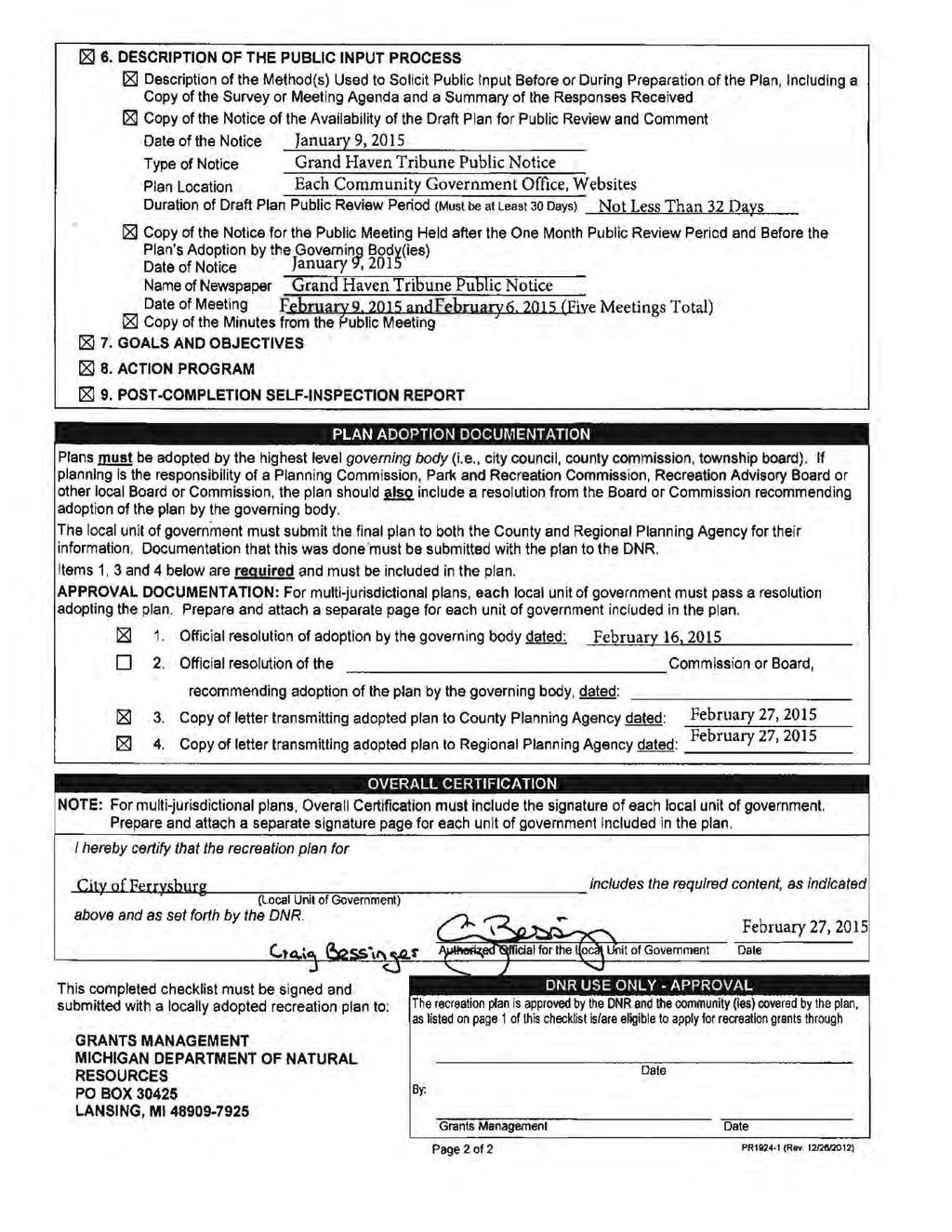
88 213
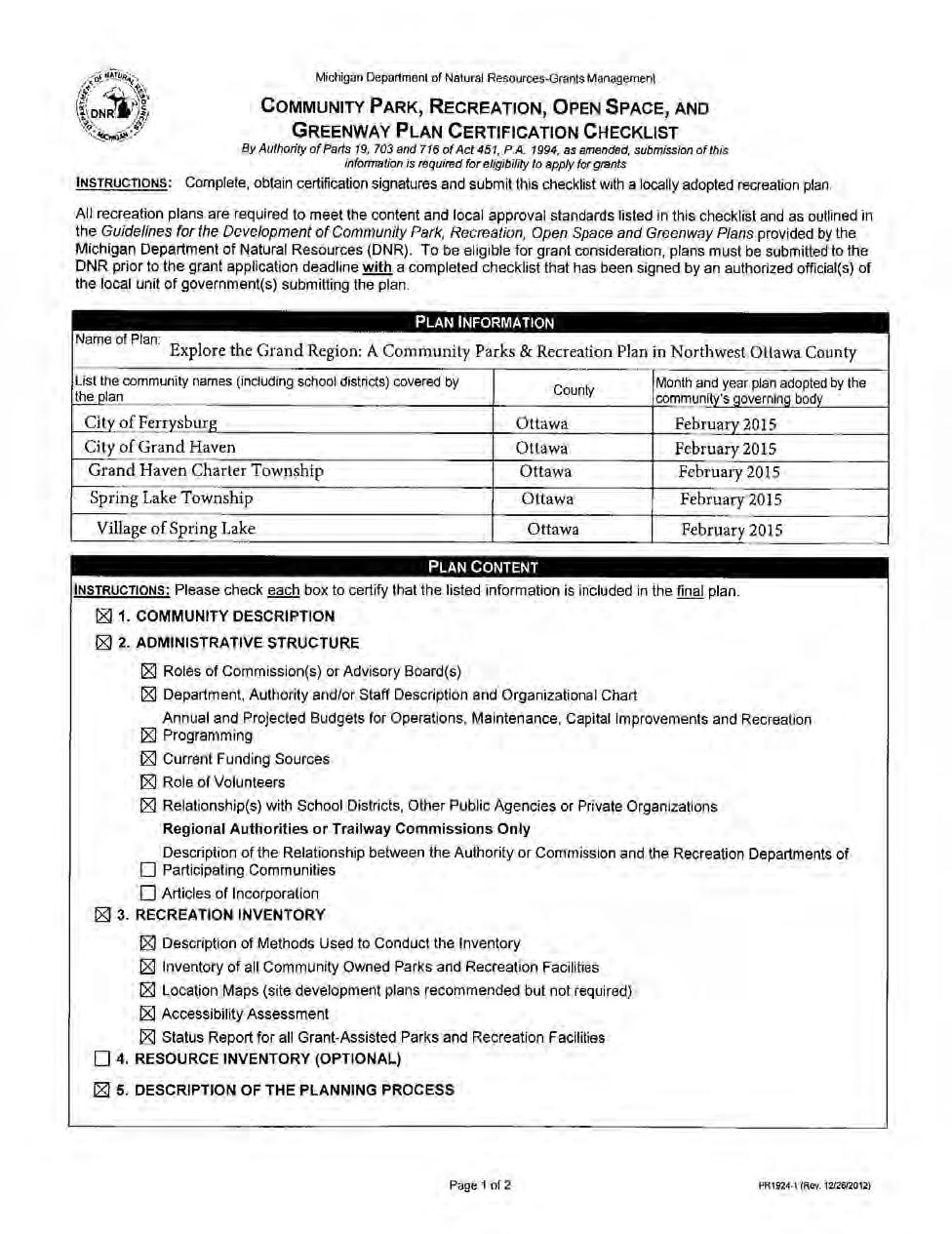
89 214
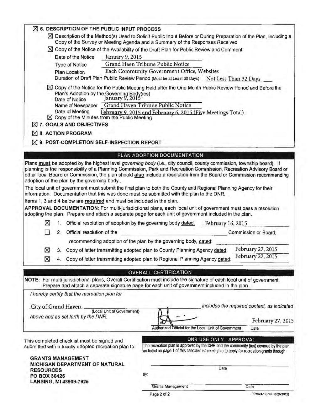
90 215
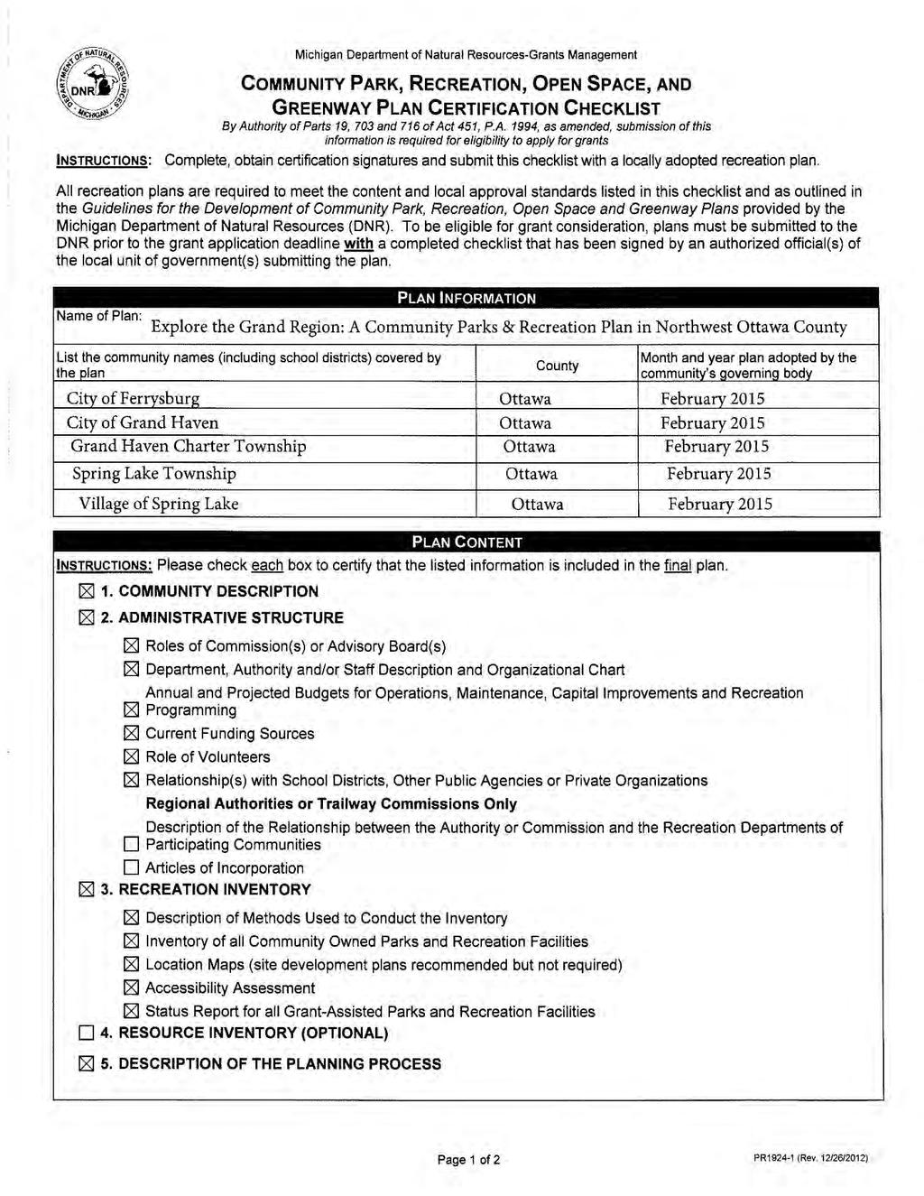
91 216
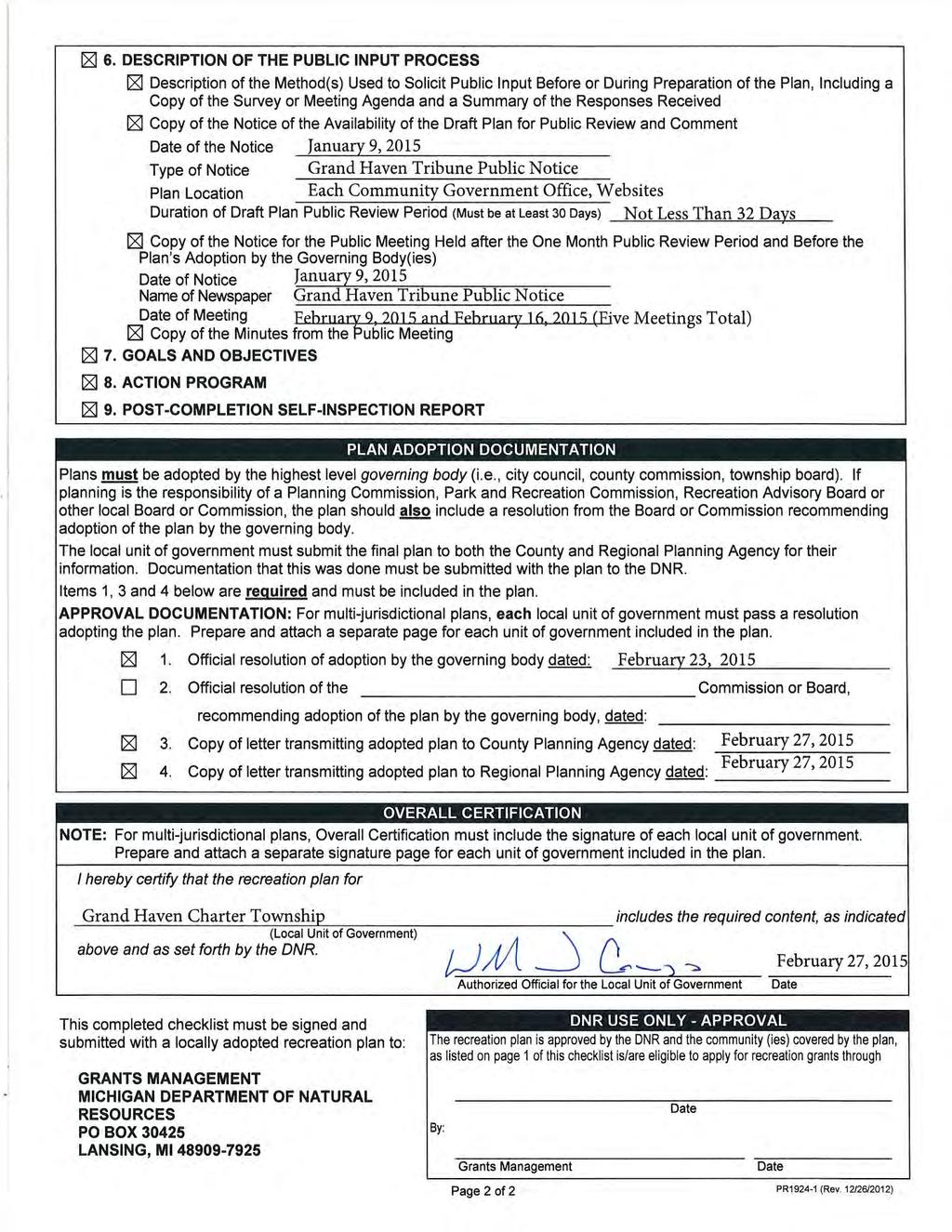
92 217
93 218
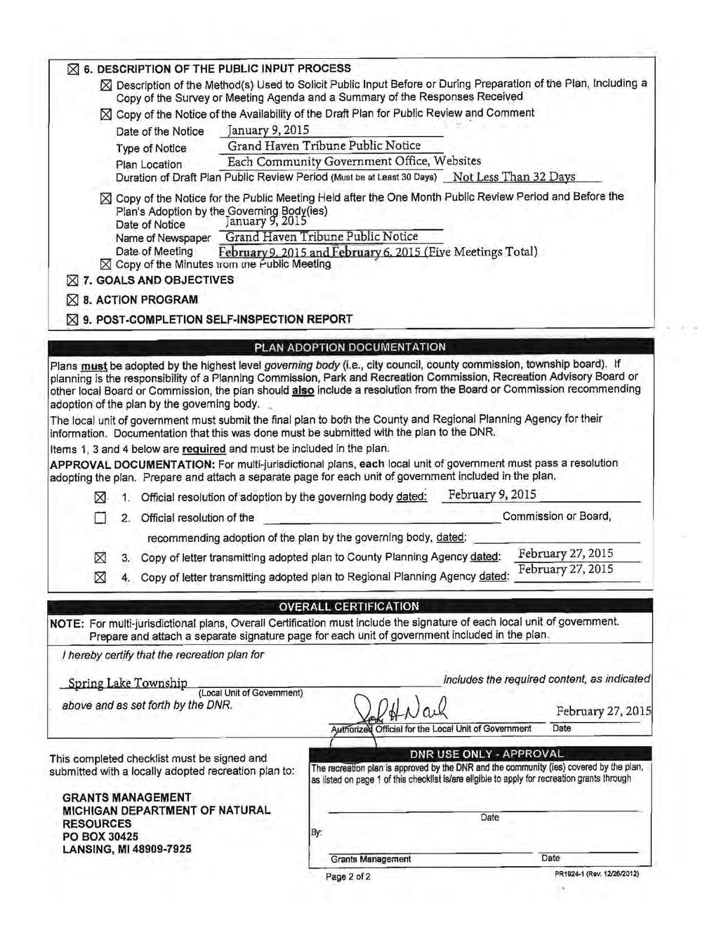
94 219
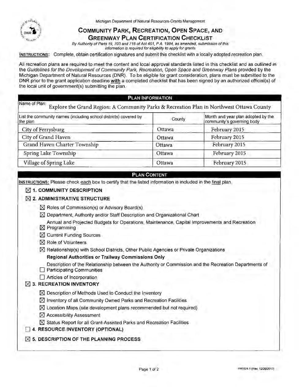
95 220
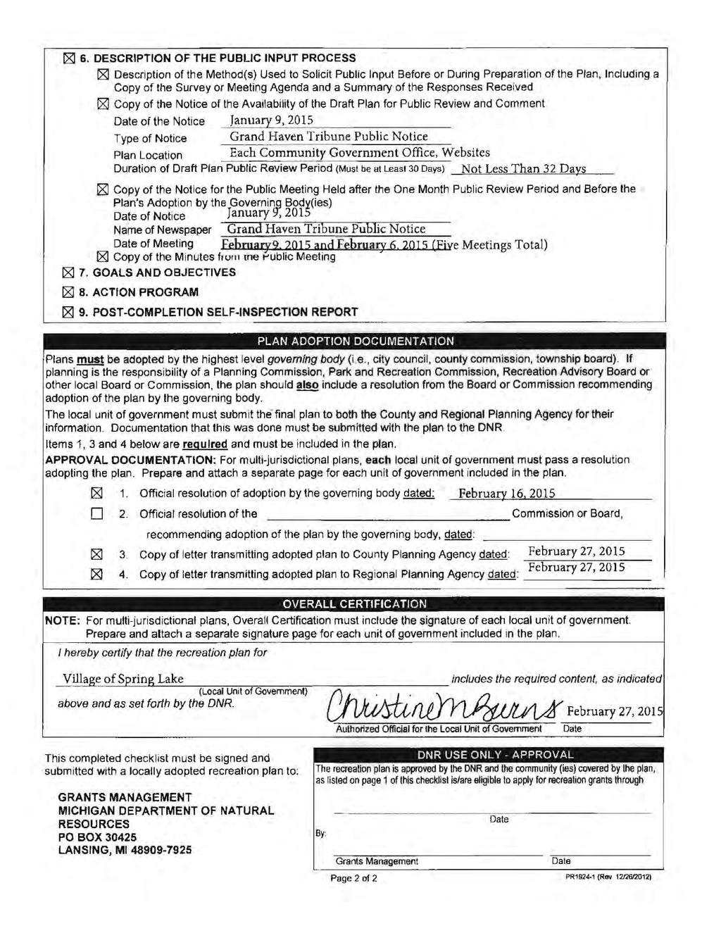
96 221
Appendix A. Park Land Definitions
 Appendix A Park Land Definitions Mini Park May serve specific function for any and all ages, depending on need of the user area. Size range 1-5 acres with optimum size being 3 acres. Service area is sub-neighborhood
PARTF Scoring System for Grants
 PARTF Scoring System for Grants The members of the N.C. Parks and Recreation Authority use the PARTF scoring system as one of several tools to select grant recipients. Please provide all of the information
Provide and maintain sufficient public parks, recreation facilities, and open space to meet the recreational needs of County residents and visitors.
 (ROS) Goal Provide and maintain sufficient public parks, recreation facilities, and open space to meet the recreational needs of County residents and visitors. OBJECTIVE ROS.01 The County shall acquire,
Chapter 6. Overall Vision RECOMMENDATIONS. More Trail and Trail. Connections. Equal Access to Park. Facilities and Programs. Water Access.
 Overall Vision More Trail and Trail Connections Equal Access to Park Facilities and Programs Water Access Environment Variety Chapter 6 RECOMMENDATIONS Chapter 6 The following recommendations for park,
Goals and Action Items
 Goals and Action Items Developing goals and action items is an important part of the recreation planning process. The overall goals of a recreation department are to provide recreation opportunities for
APPENDIX D: PARKS AND RECREATION ACTION PLAN
 APPENDIX D: PARKS AND RECREATION ACTION PLAN Goals The following goals are specific to the development, maintenance, and operation of the existing parks in the Township, as well as the acquisition and
Parks, and Recreation & Cultural Arts Master Plan Update
 Parks, and Recreation & Cultural Arts Master Plan Update Community Profile Public Input Summary: Staff Interviews conducted April 14 and 15, 2014 Citizens Workshop - conducted April 15 th and 24 th, May
City of Naples Parks Master Plan (Draft)
") City of Naples (Draft) CSAB April 12, 2016 OVERVIEW Presentation Outline Overview Needs Assessment Recap Response to Needs Implementation Strategy Questions, Discussion Preserving Naples: A vision plan
City of Naples (Draft) CSAB April 12, 2016 OVERVIEW Presentation Outline Overview Needs Assessment Recap Response to Needs Implementation Strategy Questions, Discussion Preserving Naples: A vision plan
1. Parks & Recreation Neighborhood Parks Community Parks Special Use Sites 2. Open Space 3. Trails
 Appendix A: Park Classifications The intent of parks and recreation classifications is to aid in making acquisition and design decisions for park sites, facilities and the organization of recreation space
Support the implementation of Cape Coral's Comprehensive Plan. Protect and utilize the unique natural resources in the City.
 7.0 OVERVIEW - RECOMMENDATIONS Chapter 7 The preparation of the Cape Coral Parks and Recreation Master Plan spanned a period of approximately 12 months. Plan preparation included the input of a wide range
SOUTHEAST SPORTS COMPLEX MASTER PLAN
 REPORT TO SOUTHGATE NEIGHBORHOOD COUNCIL APRIL 13, 2016 Visioning Process April 30: Stakeholder Meeting with Sports Groups May 5: Stakeholder Meeting with Southgate Land Use Committee May 13: SNC Meeting
10.0 Open Space and Public Realm
 10.0 Open Space and Public Realm 10.0 Open Space and Public Realm The Public Open Space System is comprised of: outdoor spaces available for public use that are either publicly owned (e.g., parks and
Emerson Park Master Plan Update. Public Meeting III August 27, 2014
 Emerson Park Master Plan Update Public Meeting III August 27, 2014 Meeting Agenda: Project Update Presentation of Master Plan Components Discussion and Feedback The Path Forward: Building on the Concept
PARKS & RECREATION SUBCOMMITTEE. Oct. 1, 2015
 PARKS & RECREATION SUBCOMMITTEE Oct. 1, 2015 1999 Bond - $22,000,000 Land Acquisition Allen Station Phase II Neighborhood Parks PREVIOUS BOND ELECTIONS 1999 & 2007 2002 Bond - $4,000,000 Allen Senior Recreation
City Council March 27, Parks, Recreation, and Trails Master Plan
 City Council March 27, 2018 Parks, Recreation, and Trails Master Plan Planning Process Develop Goals and Objectives Inventory of Areas and Facilities Needs Assessment And Identification Public Participation
South East Sports Complex Phase I
 South East Sports Complex Phase I City of Spokane Design Review Board August 29, 2018 (Revised) Objectives 1. Early discussion and collaboration. 2. Provide framework / catalyst for future improvements
Ottawa County Parks, Recreation & Open Space Plan. February, 2006
 2006 Ottawa County Parks, Recreation & Open Space Plan February, 2006 TABLE OF CONTENTS ACKNOWLEDGMENTS.................................................... v PLAN ADOPTION..........................................................vi
Planning for Waterfront Communities
 Planning for Waterfront Communities Redevelopment Ready Communities Supplemental Training Program OFFICE OF THE GREAT LAKES Waterfront Community Best Practices and Guidelines New supplemental criteria
Highland Falls Waterfront Redevelopment Feasibility Study Village Board Meeting March 20, 2017
 Village Board Meeting March 20, 2017 Agenda I. Public Meeting #1 Visioning Summary II. Public Meeting #2 Comment Summary III. IV. IV. Case Study: Milton Train Station Schematic Design Concepts Schedule/Next
ANCHORAGE PARK REPORT CARD Assessing A Park s Appearance, Function, & Condition
 ANCHORAGE PARK REPORT CARD Assessing A Park s Appearance, Function, & Condition Park Name: Is Your Park an A or an F? Your Name: Contact Information Optional: Date: General Instructions: Phone: Email:
{Best Practices. Summary of Tools, Strategies and Best Practices from 11 Michigan Case Study Communities
 Case Studies Michigan Coastal Community Working Waterfronts { Summary of Tools, Strategies and from 11 Michigan Case Study Communities Table of Contents Zoning...2 Community and Stakeholder Collaboration
FY Capital Improvement Program Parks and Landscaping. 8 - Summary
 PARK PROJECTS FY 211-215 Capital Improvement Program Description FY 21 FY 211 FY 212 FY 213 FY 214 FY 215 1 Restroom Bldgs (Replace or Construct)-Jefferson, McDonald, 5,774,623 4,669,623 1,15, Allendale,
RECREATION AND OPEN SPACE VISION
 City of South Lake Tahoe General Plan Policy Document Recreation and Open Space Element INTRODUCTION This element provides the policy context for the City of South Lake Tahoe to achieve its vision for
TA B L E O F C ON T EN T S
 TA B L E O F C ON T EN T S Introduction 1 Site Analysis 2 EXISTING TREE ANALYSIS 3 Community Outreach 5 PUBLIC WORK SHOP #1 GENERAL PUBLIC 6 PUBLIC WORKSHOP #2 4 TH OF JULY CELEBRATION 9 PUBLIC WORKSHOP
RECREATION AND OPEN SPACE ELEMENT GOALS, OBJECTIVES, AND POLICIES
 RECREATION AND OPEN SPACE ELEMENT GOALS, OBJECTIVES, AND POLICIES Goal 7 To provide park facilities, recreation programs, and open space resources that are safe, adequate, and accessible to all City residents,
City of Naples Parks Master Plan
 Parks Master Plan Draft Master Plan Presentation January 19, 2015 Presentation Outline Overview Needs Assessment Recap Response to Needs Implementation Strategy Questions, Discussion 2 OVERVIEW Project
Las Colonias Park Master Plan
 2013 Las Colonias Park Master Plan City of Grand Junction June 2013 Introduction Las Colonias Park, a 101 acre parcel on the edge of the Colorado River south of downtown, was deeded to the City of Grand
The Vision. Photo provided by The Minervini Group. 46 Vision, Objectives & Strategies
 Vision, Objectives & Strategies The is the public framework and guide for future development of the Grand Traverse Commons. The establishes public polices for infrastructure, the preservation of natural
Recreation Facility Evaluation - Conclusions
 2015 Parks Report Upon initial assessment of the Village parks it was evident that the inventory of the Village s park land, athletic fields, recreational facilities, playgrounds, trails, etc., was substantial,
Long Branch-Wayne Local Park Renovation Project
 Montgomery Parks Long Branch-Wayne Local Park Renovation Project Community Meeting #2 September 20, 2016 Oak View Elementary School 7:00-9:00 PM Welcome / Team Introductions M-NCPPC (Montgomery Parks)
29 Bella Fontaine Park
 29 Bella Fontaine Park 9565 Bellefontaine Road St. Louis County Parks Master Plan Planning Zone 2 Visit Date: July 2016 Page 1 129 Bella Fontaine Park 9565 Bellefontaine Road St. Louis County Parks Master
Outdoor Recreation Facilities Inventory
 Outdoor Recreation Facilities Inventory Allouez Neighborhood Parks: East Lawn Park (4.90 acres) is located in the northeastern corner of Allouez near Boyd Street. This site contains: Baseball diamond with
a) Inventory of all existing privately-owned, state-owned, or local governmentowned recreational facilities and open spaces within the context area
 Inventory of all existing privately-owned, state-owned, or local governmentowned recreational facilities and open spaces within the context area") 8.0 RECREATION AND OPEN SPACE ELEMENT (1) DATA REQUIREMENTS a) Inventory of all existing privately-owned, state-owned, or local governmentowned recreational facilities and open spaces within the context
8.0 RECREATION AND OPEN SPACE ELEMENT (1) DATA REQUIREMENTS a) Inventory of all existing privately-owned, state-owned, or local governmentowned recreational facilities and open spaces within the context
Minto-Brown Island. November 18, City of Salem, Parks & Transportation Services
 Minto-Brown Island Park Master Plan Public Meeting #1 November 18, 2014 City of Salem, Parks & Transportation Services Division, i i Public Works Welcome... and thanks for participating in the master planning
RECREATION, OPEN SPACE AND GREENWAYS ELEMENT GOALS, OBJECTIVES, AND POLICIES
 RECREATION, OPEN SPACE AND GREENWAYS ELEMENT GOALS, OBJECTIVES, AND POLICIES GOAL R-1: DEVELOP A RECREATION, OPEN SPACE AND GREENWAYS SYSTEM AS AN INTEGRAL COMPONENT OF AN OVERALL, COUNTY-WIDE ECONOMIC
Memo Preliminary. City of Miamisburg Parks Site Reconnaissance
 Memo Preliminary To: From: Ms. Rebecca Benna Woolpert, Inc. Date: Subject: City of Miamisburg Parks Site Reconnaissance The consultant team toured the existing Miamisburg Parks to assess current levels
The following principles guide the development of goals and strategies to protect and promote these amenities:
 OPEN SPACE/PARKS/TRAILS/RECREATION GOALS/STRATEGIES Cherry Hills Village is a living environment that offers low density development, open areas, public scenic vistas, public trails and public parks. This
CITY OF GAINESVILLE PARKS, RECREATION AND CULTURAL AFFAIRS DEPARTMENT VISION 2020
 CITY OF GAINESVILLE PARKS, RECREATION AND CULTURAL AFFAIRS DEPARTMENT VISION 2020 A BLUE PRINT FOR THE NEXT 20 YEARS The PRCA Vision 2020 Master Plan, adopted in November 2012, addresses the current state
Special Revenue Funds
 Special Revenue Funds Special Revenue Funds account for the proceeds of specific revenue sources (other than special assessments for major capital projects) that are legally restricted to expenditures
Historic Ottawa Beach Waterfront Walkway Park Township
 Historic Ottawa Beach Waterfront Walkway Park Township Project Description: Public access improvements to the shoreline of Lake Macatawa are the final steps in completing the park master plan for the Historic
MEMORIAL PARK MANAGEMENT PLAN
 MEMORIAL PARK MANAGEMENT PLAN Village of Elk Rapids, Michigan 2015 Developed by the Parks and Recreation Commission Planning Commission Approved, Village Council Approved, 1 Introduction The purpose of
Durango Parks & Recreation Department. Strategic Plan
 Durango Parks & Recreation Department Strategic 2019-2023 Adopted April 2019 Overview The purpose of the adopted 2010 Parks, Open Space, Trails and Recreation Master is to provide a 10-year road map for
APPENDIX D2: PARKS AND TRAILS
 APPENDIX D2: PARKS AND TRAILS Cultivate Hopkins Comprehensive Plan 8/15/18 DRAFT Cultivate Hopkins Appendix D2 1 Existing Conditions Local Parks and Trails Figure D2.1 shows the existing park and trail
PARK AND RECREATION MASTER PLAN UPDATE
 PARK AND RECREATION MASTER PLAN UPDATE 2014-2018 Prepared for: Avon Parks, Recreation and Beautification Council (PRBC) and Town of Avon Prepared by: Lehman & Lehman, Inc. 24-Apr-14 Mission Statement The
Southeast Quadrant Plan
 Southeast Quadrant Plan Southeast Quadrant Distinctive Features Land Use The Southeast Quadrant includes all the area within the planning area that is east of Interstate 5 and south of State Route 44.
6. RECREATION AND OPEN SPACE ELEMENT
 6. RECREATION AND OPEN SPACE Introduction This Recreation and Open Space Element includes Goals, Objectives and Policies (GOP) that apply to the main campus in Gainesville and the Lake Wauburg Recreation
Dowdy Park. Concept Plans TOWN OF NAGS HEAD NORTH CAROLINA. Developed by: Albemarle & Associates, Ltd VHB/ Vanasse Hangen Brustlin, Inc.
 TOWN OF NAGS HEAD NORTH CAROLINA Concept Plans Developed by: Albemarle & Associates, Ltd VHB/ Vanasse Hangen Brustlin, Inc. Site Looking Southeast Dowdy Park Existing Conditions Nags Head Woods Sound Future
G. RECREATION AND OPEN SPACE ELEMENT. The following summarizes the Recreation and Open Space Element:
 G. RECREATION AND OPEN SPACE ELEMENT The purpose of the Element is to provide the framework and direction for a comprehensive system of public and private sites for recreation, including, but not limited
ASHTABULA COUNTY COASTAL MANAGEMENT PLAN
 Location Ashtabula County, Ohio Planning Grantwriting ODNR, Office of Coastal Management, $25,000 Local Match $25,000 Size 21 miles of coastal area Professional Services 2012 Project Team Randy Mielnik,
BURTON STATION STRATEGIC GROWTH AREA PLAN UPDATE PUBLIC MEETING 3/26/18
 BURTON STATION STRATEGIC GROWTH AREA PLAN UPDATE PUBLIC MEETING 3/26/18 1 WHERE WE ARE? 2 PRIMARY OBJECTIVES OF THE PLAN UPDATE 1. Update the land use designation for Burton Station Village to reflect
City of Gainesville Parks, Recreation and Cultural Affairs Infrastructure Sales Tax City Commission Approved Project List
 City of Gainesville Parks, Recreation and Cultural Affairs Infrastructure Sales Tax City Commission Approved Project List Alfred A. Ring Park Description: Boardwalk replacement, signage and general park
SECTION FOUR: MISSION STATEMENT, GOALS & OBJECTIVES
 SECTION FOUR: MISSION STATEMENT, GOALS & OBJECTIVES Chapter Summary Chapter Ten: Mission Statement, Goals & Objectives To fulfill its mission, the Parks and Recreation Commission has identified four basic
Little Neck Planning Area
 Little Neck Planning Area Current Reality The Little Neck Planning Area is characterized by established residential neighborhoods, Town Center and Pembroke. The Eastern and Western Branches of the Lynnhaven
Centennial Hall Planning Comments Public Meetings, 9/19/2011. General Comments
 Centennial Hall Planning Comments Public Meetings, 9/19/2011 General Comments Space/Location Too tight. Acquire more space (Women s Club?) Is there a more central visitor center site? Site very important
RECREATION AND OPEN SPACE ELEMENT
 RECREATION AND OPEN SPACE ELEMENT Last amended August 19, 2008 Table of Contents Objective Page 5.1 Park system defined... 5-1 5.2 Access to parks and recreational facilities... 5-2 5.3 Recreation and
Pinellas County Greenways
 Pinellas County Greenways USING GREENWAYS TO LINK OPEN SPACES The Florida Greenways Commission has defined a greenway as...a corridor of protected open space that is managed for conservation and/or recreation.
City of Plattsburgh DRI: Downtown Streetscapes & Riverfront Access. Downtown Streetscape and Riverfront Access Design
 City of Plattsburgh DRI: Downtown Streetscapes & Riverfront Access Welcome Thank you for coming this evening. Agenda PART I - Project Context The Downtown Revitalization Program Our DRI Projects Other
FY Capital Improvement Program Parks and Landscaping - Park Projects
 PARK PROJECTS FY 219-223 Capital Improvement Program FY 218 FY 219 FY 22 FY 221 FY 222 FY 223 1 2 3 4 5 6 7 8 9 1 11 12 13 14 15 16 17 Robinson Park - Recreation Center Renovation Project (7843) Desiderio
Village of Fair Haven Goals & Objectives
 Village of Fair Haven Goals & Objectives 1 Natural Environmental Quality & Aesthetics Embrace policies and programs that preserve and enhance the Village s natural resources, environment, water quality,
STAFF RECOMMENDATION: Adopt the Parks and Recreation Master Plan 2013, or take other action as deemed appropriate.
 Regular 7. CITY COUNCIL AGENDA Meeting Date: 12/02/2013 TITLE: Parks and Recreation Master Plan 2013 Adoption Proposal - Dwight Curtis Responsible Staff: Dwight Curtis Backup Material: Backup material
Canal Winchester Parks Master Plan. Public Meeting 2 Thursday, February 2 6:30pm
 Canal Winchester Parks Master Plan Public Meeting 2 Thursday, February 2 6:30pm Meeting Agenda 1. Project overview 2. Project schedule 3. Public input results Survey Public Meeting #1 Stakeholder Interviews
PARKS AND RECREATION
 PARKS AND RECREATION WHAT YOU WILL FIND IN THIS CHAPTER: Background information on the development of the Park, Recreation, and System Plan (PRSP). General overview of Ellensburg s parks and recreation
3. VISION AND GOALS. Vision Statement. Goals, Objectives and Policies
 Vision Statement Queen Creek s interconnected network of parks, trails, open spaces and recreation opportunities provide safe and diverse activities and programs that sustain its unique, small town, equestrian
Citizen s Advisory Committee
 Citizen s Advisory Committee 13 Members 6 Meetings (5 Locations) 1 Public Meeting Numerous Report Drafts Countless Hours of Review Immeasurable Input Special Thank You To: Jack Cohen Brian Kile George
North Oakville East Parks Facilities Distribution Plan. November, 2009
 North Oakville East November, 2009 POLICY CONTEXT 1) Purpose a) The purpose of this document is to be a guide for the location, configuration, design and development of the parks system for the North Oakville
Outdoor Recreation Plan
 City of Bayfield Bayfield, Wisconsin 54814 Outdoor Recreation Plan Approved by the City of Bayfield Parks & Recreation Committee - 2015 P.O. Box 1170 Bayfield, WI 54814 715-779-5712 www.cityofbayfield.com
AVONDALE ESTATES GREENSPACE AD-HOC COMMITTEE
 AVONDALE ESTATES GREENSPACE AD-HOC COMMITTEE INVENTORY AND RECOMMENDATIONS REPORT November 7, 2018 Our Mission Statement: To provide assistance and support, through professional expertise in matters of
Bourne Downtown Site Planning
 Prepared for: The Town of Bourne, MA In Cooperation with: Bourne Financial Development Corporation Prepared by:, Inc. June 24, 2009 Table of Contents Introduction and Summary... 1 Site Existing Conditions...
PIERCE COUNTY IMPACT FEE WORKING GROUP. Pierce County s Park System
 PIERCE COUNTY IMPACT FEE WORKING GROUP Pierce County s Park System Project Title 2/25/2016 1 Pierce County s Park System Park System Concept Park Classifications Current Park Inventory Park System Comparison
The transportation system in a community is an
 7 TRANSPORTATION The transportation system in a community is an important factor contributing to the quality of life of the residents. Without a sound transportation system to bring both goods and patrons
City of Bonney Lake Allan Yorke Park. MASTER PLAN SUMMARY REPORT June 30, 2016
 City of Bonney Lake Allan Yorke Park MASTER PLAN SUMMARY REPORT June 30, 2016 TABLE OF CONTENTS INTRODUCTION PUBLIC INVOLVEMENT PROCESS MASTER PLAN North Park Central Park South Park East Park Field Development
ADOPTED CAPITAL IMPROVEMENT PROGRAM BUDGET ARROYO PROJECTS
 ADOPTED CAPITAL IMPROVEMENT PROGRAM BUDGET ARROYO PROJECTS HAHAMONGNA FY 212-216 Capital Improvement Program Priority Description Total Estimated Costs Appropriated Through FY 211 Adopted FY 212 FY 213
A Vision for Walnut Creek
 A Vision for Walnut Creek Photo: City of Clive Walnut Creek Booklet 8 of 8 Greater Des Moines Water Trails and Greenways 1 Table of Contents Booklet 1: Water Trails Strategies and Policies Booklet 2: Beaver
MARINA MARKET & WATERFRONT DEVELOPMENT STUDY PORT ARANSAS, TEXAS
 MARINA MARKET & WATERFRONT DEVELOPMENT STUDY PORT ARANSAS, TEXAS FEBRUARY 2015 PRESENTATION OUTLINE 1 2 3 4 5 6 7 REGIONAL POSITIONING SITE IMPRESSIONS PLANNING & DESIGN PRINCIPLES EXISTING IMPROVEMENTS
MASTER PLAN IMPLEMENTATION COSTS. Appendix A
 Appendix A MASTER PLAN IMPLEMENTATION COSTS Town of Bradford West Gwillimbury HENDERSON COMMUNITY PARK MASTER PLAN IMPLEMENTATION COSTS Draft Order of Magnitude Costing Revised 5/27/2014 ITEM DESCRIPTION
Visioning Committee Kick-Off Meeting
 Visioning Committee Kick-Off Meeting June 11, 2018 The Team Project management, technical analysis, implementation, report preparation Public engagement, park review Recreation facilities review, operations
Courthouse Planning Area
 Courthouse Planning Area Current Reality The Courthouse Planning Area is the characterized by expansive suburbanscale residential areas as well as the community resource planned area of athletic, educational,
Park Types and Attributes
 02 APPENDIX B APPENDIX B s and s 194 APPENDIX B 04 Size Level of Service Any privately owned park, of any size, is a neighborhood park Primary Service Area - 1/2 mile or within 15 minutes walking distance
PARKS. Chapter Introduction
 Chapter 4. PARKS 4.1. Introduction This Parks Element of the 2016 Comprehensive Plan Update provides direction and guidance, based on citizen input, in order to improve and maintain the City s existing
The only significant recreation deficiency in Conway is the absence of an integrated greenway and multipurpose trail system.
 CHAPTER 6 RECREATION 1. Introduction This recreation chapter is prepared in compliance with recently revised state statutes dealing with the completion of municipal master plans [RSA 674:2 III (F)]. This
& SUSTAINABILITY PLAN
 Chapter 6: IMPLEMENTATION, MANAGEMENT, & SUSTAINABILITY PLAN Overview The Chester Woods Master Plan presents a long-term vision for the park. While phasing of improvements is suggested, Olmsted County
Mendota Heights 2040 Comprehensive Plan Draft Vers
 4 Parks and Trails The City of Mendota Heights boasts a variety of recreational and open space opportunities. Few cities can claim access to regional trails, riverside and lakeside parks, scenic bluffs
Goal A- Create a preeminent, professionally based, fi scally sound Department of Parks and Recreation.
 City parks, trails, open spaces, urban forests, and greenways make neighborhoods more attractive places to live, strengthen community pride, offer natural environmental protection, and improve physical
DRAFT SECTION 4(F) EVALUATION KOLLINER PARK
 EVALUATION KOLLINER PARK") DRAFT SECTION 4(F) EVALUATION I. DESCRIPTION OF SECTION 4(F) RESOURCE The Section 4(f) resource potentially affected by the proposed action is Kolliner Park. The Alternative B-1 and C bridge crossings
DRAFT SECTION 4(F) EVALUATION I. DESCRIPTION OF SECTION 4(F) RESOURCE The Section 4(f) resource potentially affected by the proposed action is Kolliner Park. The Alternative B-1 and C bridge crossings
PARKS AND RECREATION ELEMENT
 PARKS AND RECREATION ELEMENT TABLE -3 First Priority 1 2 POTENTIAL SAN CARLOS TRAIL CONNECTIONS Crestview to Pulgas Ridge Open Space Preserve and San Francisco Watershed Lands Unimproved City-Owned Parcel
Neighborhood Districts
 NEIGHBORHOOD DISTRICTS SEVEN MAIN DISTRICTS Neighborhood Districts While the Development Plan provides a broad-scale overview of the neighborhood, this section focuses on uses and relationships at the
City of Mahtomedi Park System Plan Public Hearing Draft: September 13, 2006
 Chapter 6: IMPLEMENTATION INTRODUCTION Earlier chapters of this Plan analyzed existing conditions, identified park and recreation needs, and proposed park, trail, and open space recommendations. This chapter
Chapter 11 PARKS, RECREATION AND OPEN SPACE
 Chapter 11 PARKS, RECREATION AND OPEN SPACE INTRODUCTION The 2016 Parks, Recreation and Open Space Plan (Park Plan) for Gig Harbor represents the City s vision and provides goals and objectives for the
PARK DATA THEMES SUMMARY:
 area and identified key themes that should be addressed in the upcoming design process. The following is a compilation of the themes identified (organized by park). Not every park was addressed in this
THE CORPORATION OF THE TOWN OF ST. MARYS
 THE CORPORATION OF THE TOWN OF ST. MARYS DISCUSSION PAPER #8 (update) RECREATION AND PARKLAND - DRAFT - Presented to the Town of St. Marys Planning Advisory Committee on December 18, 2017 Introduction
Parks Master Plan Implementation: Phase I Waterfront Use and Design REPORT #: September 7, 2016 File #
 0 'O DI Lan-171-14 1 - THE CORPORATION OF THE TOWN OF COBOURG..,. STAFF REPORT TO: FROM: Mayor and Members of Council Dean A. Hustwick, Director of Recreation and Culture DATE OF MEETING: Committee of
BENJAMIN BANNEKER PARK FRAMEWORK PLAN (PLAN ADOPTION)
") BENJAMIN BANNEKER PARK FRAMEWORK PLAN (PLAN ADOPTION) COUNTY BOARD MEETING DECEMBER 16, 2017 County Board Consideration: Adopt the Benjamin Banneker Park Framework Plan and Design Guidelines Framework
BENJAMIN BANNEKER PARK FRAMEWORK PLAN (PLAN ADOPTION) COUNTY BOARD MEETING DECEMBER 16, 2017 County Board Consideration: Adopt the Benjamin Banneker Park Framework Plan and Design Guidelines Framework
GOALS, OBJECTIVES, POLICIES & PROGRAMS
 Chapter 5 GOALS, OBJECTIVES, POLICIES & PROGRAMS 5.1 Goals, Objectives, Policies & Programs This is a joint plan adopted by both the Village of Waunakee and the Town of Westport. Both communities will
City of Talent Capital Improvements Plan
 City of Talent Capital Improvements Plan Report Prepared For: City of Talent Prepared by: Community Planning Workshop Community Service Center 1209 University of Oregon Eugene, OR 97403-1209 Email: cpw@uoregon.edu
Parks & Recreation Annual Report
 2015 Parks & Recreation Annual Report Parks & Recreation Committee Kochville Township 11/4/2015 Parks & Recreation 5851 Mackinaw Road Saginaw, Michigan 48604 (989) 792-7596 November 4 th, 2015 To the citizens
Charles P. Johnson and Associates. Annapolis Landscape Architects
 Charles P. Johnson and Associates Annapolis Landscape Architects AGENDA Introduction Project Limits and Scope Site Analysis Opportunities & Constraints Program Goals Image Boards Design Alternatives Pros
Y Sports Complex PROGRAMMING Capitol Improvement Plan. Anticipated/Suggested Improvements. Sedgwick County Park: Sports Complex:
 PROJECT OVERVIEW Location: East of Ridge Road, between 21 st Street and 13 th Street, not including SCZ In conjunction with The Sedgwick County Park Facilities Observation Report Compilation of improvements
Welcome to the Public Meeting!
 Welcome to the Public Meeting! Please sign in, grab a paper survey, and check out the boards around the perimeter of the room. Once you ve viewed all of the boards, come join us in the middle of the room
Montana Rail Link Park
 Montana Rail Link Park Neighborhood Open House A Missoula Community Partnership WITH LEADERSHIP FROM THE FRANKLIN TO THE FORT & SOUTHGATE TRIANGLE NEIGHBORHOODS Sovereign Hope Church, (1919 North Ave.)
Appendix 4 Park, Trail, and Recreation Facilities For more information, call the Park Planning and Stewardship Division at
 Appendix 4 Park, Trail, and Recreation Facilities For more information, call the Park Planning and Stewardship Division at 301-650-4380 montgomery county planning board maryland-national capital park and