Application for Abandonment
|
|
|
- Buddy Collins
- 6 years ago
- Views:
Transcription
1 Application for Abandonment Of 6 th Street Alley Abandonment Prepared For: University Housing Group, Inc Electric Road SW, Suite C Roanoke, VA Prepared By: KRATER CONSULTING Group A Nevada professional corporation 901 Dartmouth Drive Reno, Nevada (775) July 10, 2017
2 Table of Contents I. Supporting Information A. Discussion of UNR Regional Plan B. Project Summary C. Abandonment Findings D. Neighborhood Advisory Board Information E. Conclusion II. Location Map III. Zoning/Vicinity Map IV. Site Plan V. Abandonment Application Checklist VI. Abandonment Application A. Petitions for Abandonment B. Owner Affidavits Assessor Maps C. Applicant Affidavits D. Exhibits Showing Location of Public Utilities VII. Title Reports A. Schneider B. NNUD VIII. Legal Description IX. Tract Map #24 Evans Addition
3 KRATER CONSULTING GROUP A Nevada professional corporation Krater Consulting Group Phone (775) Dartmouth Drive Fax (775) Reno, Nevada Ken@KraterConsultingGroup.Com July 10, 2017 Claudia Hanson, Planning Manager Community Development Department City of Reno P.O. Box 1900 Reno NV Dear Claudia: SUBJECT: ABANDONMENT APPLICATION UNIVERSITY HOUSING GROUP, STUDENT APARTMENTS Project Summary Supporting Information The proposed student apartment project has been planned to be fully compatible with the University of Nevada Regional Center Plan and to be an asset for both the University and Downtown Reno. Plans call for redevelopment of 3/4ths of an entire city block with lighting, landscaping, and sidewalk improvements being considered that will provide a uniform look and enhance safety and security for the entire city block. Following are excerpts from the University of Nevada Regional Center Plan pertinent to the proposed project and a description of the project that describes how the plan goals and policies will be met. Abandonment Findings are also stated and addressed. UNIVERSITY OF NEVADA REGIONAL CENTER PLAN Development Concept - University of Nevada Regional Center Plan There are three subareas within the UNRC Plan, including: 2. University District (area of proposed project) consisting of several blocks north of I-80 and land south of I- 80 within the UNRC Plan boundary. This district is intended to leverage the University s influence to catalyze residential, retail, commercial and light industrial development. The University District Should contain a mix of uses to create a vibrant university oriented neighborhood and support:
4 North Virginia Street and Evans Avenue corridors linking the campus to the downtown through enhanced streetscapes and land uses encouraging active ground floor retail and commercial uses along the North Virginia Main Street Corridor and active innovation and research uses along the Evans Innovation Corridor. Zoning should support a variety of housing and commercial uses, university innovation and research partnership opportunities, office, maker/light industrial, startup/incubator space, and community service uses. University of Nevada Regional Center Plan Maps, Goals, and Policies (following pages) Page 2

5 MAP 2: DEVELOPMENT CONCEPT PHASE 2 LAND USE University of Nevada Regional Center Plan Page 3 City of Reno Master Plan April 27, 2016


6 MAP 5: TRANSIT CONCEPT Source: UNR Campus Master Plan University of Nevada Regional Center Plan Page 9 City of Reno Master Plan April 27, 2016


7 MAP 6: PEDESTRIAN FACILITIES Source: UNR Campus Master Plan University of Nevada Regional Center Plan Page 10 City of Reno Master Plan April 27, 2016


8 MAP 7: BICYCLE NETWORK Source: UNR Campus Master Plan University of Nevada Regional Center Plan Page 11 City of Reno Master Plan April 27, 2016
9 Land Use, Streetscape and Urban Design Medical marijuana establishments and non-restricted gaming should be prohibited within the UNRC Plan area. The appropriateness of bar uses and restricted/accessory gaming for properties in the University District south of Interstate 80 should be further evaluated. Zoning overlay standards should be evaluated within the Gateway Precinct to consider specific building design standards, such as brick facades, to ensure continuation of the university campus aesthetic as it interfaces with University District development. The portions of North Virginia Street and Evans Avenue adjacent to the University Campus should include generous sidewalks on both sides of the street. As redevelopment occurs, sidewalks should be widened to at least ten feet and be shaded by trees. An urban-scaled minimum build-to line of twelve feet from face of curb for at least 75% of street frontage for sidewalks, including: trees, street furniture, lighting and other urban amenities should be established in the University Districts. A unified design standard for North Virginia Street and Evans Avenue should be developed. Landscaping should create a comfortable low water use environment and attractive tree canopy that encourages preservation of mature trees. Circulation and Public Rights-of-Way The City should consider supporting the permanent/managed closing or abandonment of public streets, alleys and easements within the Gateway Precinct in order to facilitate the objectives of the UNRC Plan and Gateway concept, subject to thorough review of traffic impacts, including without limitation impacts on historic resources. In order to promote a pedestrian-friendly environment, the City should evaluate necessary street improvements to facilitate intensification of the University District and Gateway Precinct, including the feasibility of returning the one way couplets south of Interstate 80 to two-way traffic flows. In order to enhance bicycle access, bike facility improvements should be made on Virginia Street and Evans Avenue. The City should collaborate with the Regional Transportation Commission to widen the public right-of-way on North Virginia Street adjacent to the Gateway University of Nevada Regional Center Plan Page 13 City of Reno Master Plan April 27, 2016
10 Precinct to accommodate bus-only lanes, a northbound bus turnout, wider sidewalks, bicycle parking and placement of street trees. The City should encourage pedestrian safety and traffic calming improvements at Evans Avenue and 9 th Street. The City should collaborate with RTC and prioritize traffic calming strategies, increased lighting, additional marked crossings with flashing beacons, and sidewalk widening. The City should revisit its on-street parking permit program in the University area to ensure effectiveness and adequate enforcement. The City should ensure that residents of developments within the plan area north of Interstate 80 granted parking reductions are ineligible to receive on-street parking permits. IMPLEMENTATION Amended land use designations and zoning districts, as well as modified Reno Municipal Code provisions, are necessary to implement the development and circulation concepts in this plan. Land Use The University of Nevada Regional Center is designated as Special Planning Area in the Reno Land Use Plan. This designation recognizes that customized land use and zoning provisions are appropriate and provisions of this regional center plan govern land use and development within the plan area. Zoning The majority of the Plan area was rezoned to the Mixed Use (MU) base zoning district and University Regional Center Planning Area (UNRC) Overlay at the time this Plan was first adopted in Mixed use development (i.e. combinations of uses) is allowed in this zone with specific modifications to land uses, development standards and processing requirements identified in the University Regional Center Planning Area Overlay in Reno Municipal Code. University of Nevada Regional Center Plan Page 14 City of Reno Master Plan April 27, 2016

11 PROJECT SUMMARY The proposed student apartment project will consist of approximately 200 apartment units on 56,000 sq. ft. of property for a floor area ratio of over 150 units per acre; far exceeding code requirements. We plan to have approximately 560 bedrooms within the 200 +/- units or 2.8 bedrooms per apartment. Over fifty percent of the street frontage along Virginia Street, 6 th Street, Center Street, and 7 th Street will be dedicated to a mix of pedestrian friendly uses including a pet care station and an enclosed bicycle center with storage for 170 +/- bicycles (Note that the University of Nevada Regional center depicts Center Street as an important bicycle entrance into campus). Additional pedestrian related uses include a package concierge service, a fitness center, a two-story lounge and café, a leasing office and a business center. We are also dedicating space for student artwork along 7 th Street to allow residents to work together to display their personal, class, and university artwork. Although the Showboat motel and Travel Lodge located on the corner of Virginia and 7 th Street will remain for the time being, we are investigating the potential for continuation of new sidewalk, street trees, and street lighting around the two public streets (Virginia and 7 th ) to enhance safety and security and improve the visual appearance of the area for residents of the student apartment complex. The leasing center, business center, and lounge/café are located on 7 th Street closest to the main entrance to campus. An area will be dedicated to the display of artwork along 7 th Street to enhance the entrance into the complex and create pride among residents. Plans call for abandonment of the southern one-half of the alley that runs from 6 th Street to 7 th Street between Virginia Street and Center Street. The southern portion of the alley is in very poor shape. Upon demolition of the few remaining homes that are in extremely poor condition with little or no maintenance or upkeep over the last few decades, there is no reason to have a public alley for the proposed project. The north half of the alley will remain allowing access to parking spaces and trash dumpsters in the adjoining Showboat motel and Travel Lodge. (See below looking from 7 th Street). Note that there are several openings in the motel buildings that allow vehicle access to the alley so access to the motel will be negligibly affected with the alley abandonment. View of Alley looking South from 7 th Street. Page 9
12 The student apartment project will only have access from 6 th and 7 th Streets, consistent with the historical theme of alleys where vehicle and service access to homes was from the alley. Trash facilities will be located along 6 th Street where curb parking is available for Waste Management trucks to pull out of the through travel lane for curb-side service. Trash compactors will be used to minimize the need for trash pickup (twice weekly trash pickup is planned) and recycle facilities will be located adjacent to the package concierge area to encourage recycling and minimize the amount of trash going to the local landfill. Existing utility facilities will be abandoned or relocated as needed including a short storm drain line just north of 6 th street, two sanitary sewer lines and an overhead electric line that provide service to homes and businesses along the alley and the Bank of America building located north of 7 th Street PERTINENT SECTIONS OF THE RENO MUNICPAL CODE Section Nonresidential and Mixed-Use Base Zoning Districts. (a) MU Mixed Use District. The following standards shall apply to all development in a MU District: (9) Architecture and Site Layout. e. At least 50 percent of the width of a new or reconstructed first story building wall facing a street shall be devoted to pedestrian entrances, display windows, or windows affording views to retail, office, restaurant, or lobby space. FINDINGS ARTICLE VI: - ABANDONMENT Section Review Process (c) Findings. In approving any abandonment, the city council shall find the following: (1) The public will not be materially injured by the proposed abandonment. NEIGHBORHOOD ADVISORY BOARD The project lies in Ward 5, Councilwoman Neoma Jardon s ward. We look forward to presenting the project and abandonment request to the next available Ward 5 meeting. CONCLUSION This project has been designed to fully comply with the University of Nevada Regional Center Plan and Reno city code. In fact, the proposed project will exceed code requirements in many aspects and finally begin the process of linking downtown Reno with the University in a significant fashion. The close proximity to the original campus entrance on Center Street, transit facilities, bicycle facilities Page 10
13 and corridors, downtown restaurants, and special events will create a unique and desirable living environment for students and enhance their University experience. The proposed abandonment of the south one-half of the north-south alley that runs between 6 th and 7 th Streets between Virginia Street and Center street will fully comply with the finding that must be made in order for the city council to approve the abandonment The public will not be materially injured by the proposed abandonment. With development of the project, not only will the alley not be needed, the entire block will be far more attractive without an alley running the length of the block. The City of Reno does not have the financial resources to maintain this alley and adequate access will be provided for the Showboat motel and Travel Lodge. Calls for service will be reduced upon redevelopment of this block and this entire quadrant of the downtown Reno are will be greatly enhanced. We greatly appreciate your consideration of this matter. Please do not hesitate to contact me with any questions. Sincerely, Kenneth Krater, P.E. Page 11

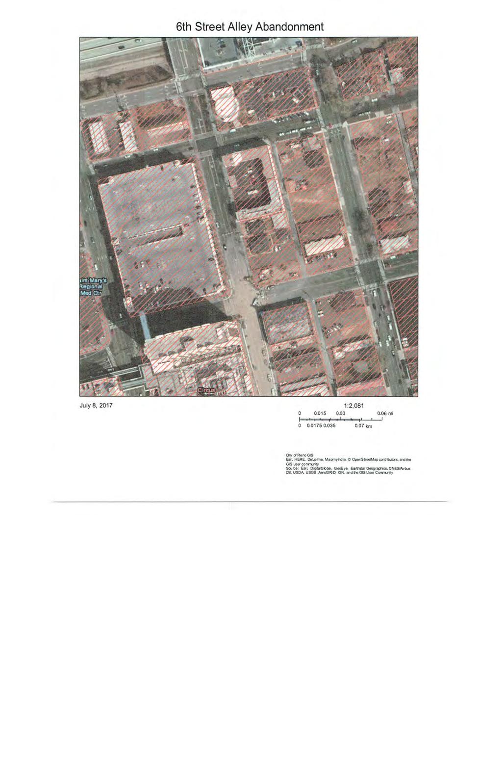
14 6th Street Alley Abandonment July 7, :2, mi km City of Reno GIS Esri, HERE, DeLorme, MapmyIndia, OpenStreetMap contributors, and the GIS user community Source: Esri, DigitalGlobe, GeoEye, Earthstar Geographics, CNES/Airbus DS, USDA, USGS, AeroGRID, IGN, and the GIS User Community
15
16 SITE PLAN
17
18
19
20

21
22
23
24
25 6th and Virginia SD City of Reno FacilitiesMap // 5/24/2017 2:32 PM // thomasj

26 6th and Virginia SS City of Reno FacilitiesMap // 5/24/2017 2:24 PM // thomasj
27 TITLE REPORT Schneider Trust
28
29
30
31
32
33
34
35
36
37
38
39 TITLE REPORT NNUD
40
41
42
43
44
45
46
47
48
49
50
51
52
53
54
55
56
57
58
59
60
61
62
63
64 LEGAL DESCRIPTION ALLEY ABANDONMENT
65 EXHIBIT A ABANDONMENT DESCRIPTIONS Portions of that alley lying within Block 8 of Evans North Addition to Reno, as shown on the plat thereof, recorded on December 16, 1879 as Tract Map 24 in the office of the County Recorder of Washoe County, Nevada, and situate within the north one-half of Section 11, T19N, R19E, MDM, Reno, Nevada, more particularly described as follows: Area to be merged with Lot 1 (APN ): All that portion of the west one-half of said alley lying north of the northerly line of East 6th Street and south of the extension of the northerly line of Lot 1 of said Block 8; being approximately 10 feet in width by 50 feet in length. Containing 500 square feet, more or less. Area to be merged with Lot 2 (portion APN ): All that portion of the west one-half of said alley lying north of the extension of the southerly line and south of the extension of the northerly line of Lot 2 of said Block 8; being approximately 10 feet in width by 50 feet in length. Containing 500 square feet, more or less. Area to be merged with Lot 3 (portion APN ): All that portion of the west one-half of said alley lying north of the extension of the southerly line and south of the extension of the northerly line of Lot 3 of said Block 8; being approximately 10 feet in width by 50 feet in length. Containing 500 square feet, more or less. Area to be merged with Lot 4 (APN ): All that portion of the west one-half of said alley lying north of the extension of the southerly line and south of the extension of the northerly line of Lot 4 of said Block 8; being approximately 10 feet in width by 50 feet in length. Containing 500 square feet, more or less. Area to be merged with Lot 13 (APN ): All that portion of the east one-half of said alley lying south of the extension of the northerly line and north of the extension of the southerly line of Lot 13 of said Block 8; being approximately 10 feet in width by 50 feet in length. Containing 500 square feet, more or less. Area to be merged with Lot 14 (APN ): All that portion of the east one-half of said alley lying south of the extension of the northerly line and north of the extension of the southerly line of Lot 14 of said Block 8; being approximately 10 feet in width by 50 feet in length. Containing 500 square feet, more or less.
66 Area to be merged with Lot 15 (APN ): All that portion of the east one-half of said alley lying south of the extension of the northerly line and north of the extension of the southerly line of Lot 15 of said Block 8; being approximately 10 feet in width by 50 feet in length. Containing 500 square feet, more or less. Area to be merged with Lot 16 (APN ): All that portion of the east one-half of said alley lying north of the northerly line of East 6th Street and south of the extension of the northerly line of Lot 16 of said Block 8; being approximately 10 feet in width by 50 feet in length. Containing 500 square feet, more or less. C and M Engineering 5488 Reno Corporate Drive, Suite 200B Reno, NV 89511
67
Policies and Code Intent Sections Related to Town Center
 Policies and Code Intent Sections Related to Town Center The Town Center Vision is scattered throughout the Comprehensive Plan, development code and the 1994 Town Center Plan. What follows are sections
Urban Design Brief December 23, 2015 Southside Construction Group Official Plan & Zoning By-Law Amendment
 Urban Design Brief Proposed Official Plan & Zoning By-Law Amendment 3244, 3263 and 3274 Wonderland Road South Southside Group December 23, 2015 TABLE OF CONTENTS Page No. INTRODUCTION... 1 SECTION 1 LAND
EXISTING COMPREHENSIVE PLAN
 EXISTING COMPREHENSIVE PLAN Town Center Land Use Element: V. LAND USE POLICIES Town Center Mercer Island's business district vision as described in "Your Mercer Island Citizen-Designed Downtown" was an
November 2, 2015 at 5:15pm City Council Chambers, 3rd Floor, City Hall, 1737 Main Street Columbia, South Carolina 29201
 Subject Property: PLANNING COMMISSION SITE/SUBDIVISION PLAN CASE SUMMARY 10.21 ACRES, WESTSIDE OF CLIF KINDER BOULEVARD COTTAGES AT BURNSIDE FARM BURNSIDE FARMS ASSOCIATES, LLC November 2, 2015 at 5:15pm
ORDINANCE AN ORDINANCE TO ADD A NEW SECTION 4.N. IN THE ZONING CODE FOR THE TOWN OF MIDDLETOWN, RELATING TO MIXED-USE DEVELOPMENT
 Introduced: November 5, 2018 Approved: ORDINANCE 18-11-01 AN ORDINANCE TO ADD A NEW SECTION 4.N. IN THE ZONING CODE FOR THE TOWN OF MIDDLETOWN, RELATING TO MIXED-USE DEVELOPMENT BE IT ENACTED BY THE MAYOR
REQUEST Current Zoning: O-15(CD) (office) Proposed Zoning: TOD-M(CD) (transit oriented development mixed-use, conditional)
 (office) Proposed Zoning: TOD-M(CD) (transit oriented development mixed-use, conditional)") Rezoning Petition 2016-117 Zoning Committee Recommendation January 4, 2017 REQUEST Current Zoning: O-15(CD) (office) Proposed Zoning: TOD-M(CD) (transit oriented development mixed-use, conditional) LOCATION
Rezoning Petition 2016-117 Zoning Committee Recommendation January 4, 2017 REQUEST Current Zoning: O-15(CD) (office) Proposed Zoning: TOD-M(CD) (transit oriented development mixed-use, conditional) LOCATION
Chapter PEDESTRIAN COMMERCIAL (PC) ZONING DISTRICT
 ZONING DISTRICT") Chapter 11-17 PEDESTRIAN COMMERCIAL (PC) ZONING DISTRICT Sections: 11-17-01 GENERAL PURPOSE 11-17-02 PERMITTED BUILDING TYPES 11-17-03 USES PERMITTED WITH DESIGN REVIEW 11-17-04 USES PERMITTED BY CONDITIONAL
Chapter 11-17 PEDESTRIAN COMMERCIAL (PC) ZONING DISTRICT Sections: 11-17-01 GENERAL PURPOSE 11-17-02 PERMITTED BUILDING TYPES 11-17-03 USES PERMITTED WITH DESIGN REVIEW 11-17-04 USES PERMITTED BY CONDITIONAL
KEIZER STATION PLAN INTRODUCTION
 KEIZER STATION PLAN INTRODUCTION Planning for this area began in 1987 when the Keizer Comprehensive Plan established the Chemawa Activity Center and McNary Activity Center. The first Chemawa Activity Center
EXHIBIT A. Tax Increment Reinvestment Zone No. 1 (Town Center) First Amended Project Plan 1
 First Amended Project Plan 1") EXHIBIT A Tax Increment Reinvestment Zone No. 1 (Town Center) First Amended Project Plan 1 1 As amended by Resolution No. 2008-02-001(TR1R) of the Tax Increment Reinvestment Zone No.1, and approved to
EXHIBIT A Tax Increment Reinvestment Zone No. 1 (Town Center) First Amended Project Plan 1 1 As amended by Resolution No. 2008-02-001(TR1R) of the Tax Increment Reinvestment Zone No.1, and approved to
MEMORANDUM. DATE: March 15, Chairman and Members Community Redevelopment Agency. Leif J. Ahnell, C.P.A., C.G.F.O. Executive Director
 MEMORANDUM DATE: March 15, 2019 TO: FROM: Chairman and Members Community Redevelopment Agency Leif J. Ahnell, C.P.A., C.G.F.O. Executive Director SUBJECT: Camino Square, IDA No. CRP-16-02, located at 171
Johnson County I-69. Corridor Plan DRAFT DRAFT
 Johnson County I-69 Corridor Plan July 2018 JOHNSON COUNTY CORRIDOR PLAN This page intentionally left blank TABLE OF CONTENTS Chapter 1: Executive Summary... Chapter 2: Introduction... Chapter 3: Existing
Planning Districts INTRODUCTION
 INTRODUCTION To facilitate detailed examination of development prospects for all areas of the community, Delano has been divided into 14 planning districts. The location of these planning districts is
STAFF REPORT TO COUNCIL PLANNING AND DEVELOPMENT
 DATE: April 29, 2013 STAFF REPORT TO COUNCIL PLANNING AND DEVELOPMENT 1100 Patricia Boulevard, Prince George, B.C., V2L 3V9 TO: FROM: SUBJECT: MAYOR AND COUNCIL JESSE DILL, PLANNER Development Variance
B. Blocks, Buildings and Street Networks
 B. Blocks, Buildings and Street Networks Figure IV.4 A rational block pattern with connected streets Introduction The single most important element in the physical and functional integration of mixed use
K. SMART ASSOCIATES LIMITED
 Planning Justification Report Zoning By-Law Amendment 185 King Street North Waterloo, Ontario April 7th, 2017 Project Reference Number 16-245 K. SMART ASSOCIATES LIMITED CONSULTING ENGINEERS AND PLANNERS
MIXED-USE ZONING DISTRICT DESIGN GUIDELINES
 MIXED-USE ZONING DISTRICT DESIGN GUIDELINES In addition to the development regulations contained in the Mixed-Use Zoning District, design guidelines are presented here to provide an added level of definition
Building & Site Design Standards Application
 FOR OFFICE USE ONLY Design standards plan review fee Building & Site Design Standards Application Phone: 208-468-5406 Fax: 208-468-5439 411 3rd Street South Nampa, Idaho 83651 5,000
VIRGINIA DRIVE SPECIAL PLAN
 August 15, 2017 Staff Report to the Municipal Planning Board CASE #GMP2017-10006 & LDC2017-00231 Item # 7 VIRGINIA DRIVE SPECIAL PLAN Location Map Subject Site SUMMARY Applicant City of Orlando, Planning
I. Introduction. Prior Approvals
 Statement of Justification First National Bank 19790 Crystal Rock Drive, Germantown, Maryland Application for Site Plan and Limited Preliminary Plan Amendment I. Introduction DPH Architecture, for First
ORDINANCE NO.:
 ORDINANCE NO.: 2016-003 Granting encroachment to Lisa Hosti for installation and maintenance of an ornamental iron fence within the right of way area of the 2300 block of Blossom Street adjacent to her
Harmony Technology Park Third Filing, Second Replat Custom Blending, Project Development Plan/Final Development Plan - FDP #130021
 ITEM NO FDP #130021 MEETING DATE July 23, 2013 STAFF Pete Wray ADMINISTRATIVE TYPE I HEARING STAFF REPORT PROJECT: APPLICANT: OWNER: Harmony Technology Park Third Filing, Second Replat Custom Blending,
Request Alternative Compliance to the prescribed criteria of the Oceanfront Resort District Form- Based Code. Staff Recommendation Approval
 Applicant Property Owner Steven H. Murden Public Hearing June 14, 2017 City Council Election District Beach Agenda Item 8 Request Alternative Compliance to the prescribed criteria of the Oceanfront Resort
Figure Example of out door dining in the public right-of-way.
 Section 2 Core Area Goal 2.2.1 To maintain and enhance the character of existing streets in the Downtown Area. Character Figure 2.2.1 Example of out door dining in the public right-of-way. A. Provide street
ELMVALE ACRES SHOPPING CENTRE MASTER PLAN
 ELMVALE ACRES SHOPPING CENTRE MASTER PLAN Contents 1.0 INTRODUCTION... 2 2.0 LOCATION... 2 3.0 EXISTING CONTEXT... 2 4.0 VISION & GUIDING PRINCIPLES... 2 5.0 LAND USE AND BUILT FORM... 4 5.1 St. Laurent
Highland Village Green Design Guidelines
 Highland Village Green Design Guidelines Publishing Information Title Highland Village Green Design Guidelins Author The City of Calgary Status DRAFT - Proposed document subject to changes Additional Copies
STAFF REPORT DEVELOPMENT COMMISSION ZONING MEETING CITY OF COLUMBUS, OHIO JANUARY 10, 2019
 STAFF REPORT DEVELOPMENT COMMISSION ZONING MEETING CITY OF COLUMBUS, OHIO JANUARY 10, 2019 5. APPLICATION: Z18-063 Location: 4053 WEST BROAD STREET (43228), being 6.42± acres located at the southeast corner
Town Center (part of the Comprehensive Plan)
") Town Center (part of the Comprehensive Plan) Mercer Island Town Center Looking North (2014) In 1994, a year-long process culminated in a set of design guidelines and code requirements for the Town Center
Town Center (part of the Comprehensive Plan) Mercer Island Town Center Looking North (2014) In 1994, a year-long process culminated in a set of design guidelines and code requirements for the Town Center
Rezoning Petition Pre-Hearing Staff Analysis September 17, 2018
 Rezoning Petition 2017-043 Pre-Hearing Staff Analysis September 17, 2018 REQUEST Current Zoning: R-3 (single family residential), R-17MF (multi-family residential), and CC (commercial center) Proposed
Study Area. Capitol Way. Greening America s Capitals 11/13/2014. A Greening America s Capitals Project
 Olympia, WA: Greening Capitol Way Supporting Communities move towards sustainability is a priority for the federal government. A Greening America s Capitals Project Office of Sustainable Communities U.S.
SUBCHAPTER 4-B GUIDELINES FOR THE B-3 COMMERCIAL CHARACTER AREA
 1 SUBCHAPTER 4-B GUIDELINES FOR THE B-3 COMMERCIAL CHARACTER AREA Downtown Bozeman should be the location of buildings of greatest height and intensity in the community. The following guidelines apply
STAFF REPORT Agenda Item: J.4 To: Mayor and City Council Date:
 STAFF REPORT Agenda Item: J.4 To: Mayor and City Council Date: 2-14-2007 Thru: Charles McNeely, City Manager Subject: Staff Report: Approval of a project to be submitted for the NDOT 2007-2009 Landscape
Be it enacted by the Town Board of the Town of Guilderland that the following new A (Transit Oriented Development (TOD) District) is adopted:
 District) is adopted:") Local Law No. 4 of 2018 (Adoption of 280-18A (Transit Oriented Development District) Be it enacted by the Town Board of the Town of Guilderland that the following new 280-18A (Transit Oriented Development
Local Law No. 4 of 2018 (Adoption of 280-18A (Transit Oriented Development District) Be it enacted by the Town Board of the Town of Guilderland that the following new 280-18A (Transit Oriented Development
CITY PLANNING COMMISSION AGENDA. ITEM NO(s): C.1 C.3 STAFF: STEVE TUCK
: C.1 C.3 STAFF: STEVE TUCK") Page 34 CITY PLANNING COMMISSION AGENDA ITEM NO(s): C.1 C.3 STAFF: STEVE TUCK FILE NOS: CPC ZC 12-00035 QUASI-JUDICIAL CPC NV 12-00036 QUASI-JUDICIAL AR DP 12-00039 QUASI-JUDICIAL PROJECT: APPLICANT: OWNER:
Page 34 CITY PLANNING COMMISSION AGENDA ITEM NO(s): C.1 C.3 STAFF: STEVE TUCK FILE NOS: CPC ZC 12-00035 QUASI-JUDICIAL CPC NV 12-00036 QUASI-JUDICIAL AR DP 12-00039 QUASI-JUDICIAL PROJECT: APPLICANT: OWNER:
CITY OF MERCER ISLAND DESIGN COMMISSION STAFF REPORT
 CITY OF MERCER ISLAND DESIGN COMMISSION STAFF REPORT Agenda Item: 2 March 9, 2011 Project: Description: Applicant: DSR11-004 The applicant is requesting approval to replace the existing exterior wood framed
The transportation system in a community is an
 7 TRANSPORTATION The transportation system in a community is an important factor contributing to the quality of life of the residents. Without a sound transportation system to bring both goods and patrons
CHAPTER 3. Design Standards for Business, Commercial, Industrial, Recreational and Institutional Uses
 CHAPTER 3 Design Standards for Business, Commercial, Section Number Title Ordinance Number Date of Ordinance 16-3-1 Applicability 2006-11 2008-04 07-01-08 16-3-2 Uniform Standards for Architectural Design
Design Review Application *Please call prior to submittal meeting to determine applicable fees*
 CITY OF EAGLE 660 E. Civic Lane, Eagle, ID 83616 Phone#: (208) 939-0227 Fax: (208) 938-3854 Design Review Application *Please call prior to submittal meeting to determine applicable fees* FILE NO.: CROSS
OPPORTUNITY SITES. A. Introduction. Chapter 5
 OPPORTUNITY SITES A. Introduction As described in Chapter 2, the land use framework establishes an organizing structure for where and how growth within the plan area will occur. The land use framework
CITY OF RENO APRIL Progressive Urban Management Associates (P.U.M.A.) in association with. Economic and Planning Systems (EPS)
 in association with. Economic and Planning Systems (EPS)") CITY OF RENO APRIL 2017 City of Reno, Nevada Prepared By Progressive Urban Management Associates (P.U.M.A.) in association with Economic and Planning Systems (EPS) EXECUTIVE SUMMARY The City of Reno Downtown
CITY OF RENO APRIL 2017 City of Reno, Nevada Prepared By Progressive Urban Management Associates (P.U.M.A.) in association with Economic and Planning Systems (EPS) EXECUTIVE SUMMARY The City of Reno Downtown
TEMPLE MEDICAL & EDUCATION DISTRICT
 City of Temple, Texas TEMPLE MEDICAL & EDUCATION DISTRICT 1 Description. The City of Temple joined in partnership with key public and private entities to jointly promote education and medical activities
8 February 9, 2011 Public Hearing APPLICANT: 7-ELEVEN, INC.
 . 8 February 9, 2011 Public Hearing APPLICANT: REQUEST: Conditional Use Permit for an automobile service station with a convenience store ADDRESS / DESCRIPTION: 2448 Nimmo Parkway PROPERTY OWNER: COURTHOUSE
MIXED-USE VILLAGE OVERLAY FLOATING DISTRICT
 MIXED-USE VILLAGE OVERLAY FLOATING DISTRICT Zoning regulations developed by committee to the Planning Board for the Town of DeWitt, NY Issue date: 13 July 2017 revised 3/12/2018, revised 4/26/2018, 5/9/2018
July 12, Columbus City Council City Hall 90 West Broad Street Columbus, OH RE: I-70/71 Columbus Crossroads Project
 OHIO DEPARTMENT OF TRANSPORTATION DISTRICT 6 400 EAST WILLIAM STREET DELAWARE, OHIO 43015 800.372.7714 Columbus City Council City Hall 90 West Broad Street Columbus, OH 43215-9015 RE: I-70/71 Columbus
Table L-1 Summary Action Strategy. Action Item Timing Status Responsible Agency
 CHAPTER 4: CIRCULATION ELEMENT ISSUE #1: MAJOR THOROUFARES AND TRANSPORTATION ROUTES A balanced transportation system for Fontana is provided that meets the mobility needs of current and future residents
5.1.1 The streetscape along US Highway 64 (Brevard Road); and, The built environment within new residential developments; and,
; and, The built environment within new residential developments; and,") Article 5. Landscaping 5.1 Purpose The Town of Laurel Park s landscape standards are designed to create a beautiful, aesthetically pleasing built environment that will complement and enhance community
Article 5. Landscaping 5.1 Purpose The Town of Laurel Park s landscape standards are designed to create a beautiful, aesthetically pleasing built environment that will complement and enhance community
TABLE OF CONTENTS 1.0 INTRODUCTION... 3
 TABLE OF CONTENTS 1.0 INTRODUCTION... 3 1.1. BACKGROUND... 3 1.2. THE PROPOSAL... 5 2.0 EXISTING POLICY FRAMEWORK... 5 2.1. PROVINCIAL POLICY STATEMENT (PPS)... 5 2.2. CITY OF LONDON OFFICIAL PLAN (OP)...
The University District envisions, in its neighborhood
 Envisioning the University District Link Light Rail in Seattle s neighborhoods CIY OF SEALE CONCEP-LEVEL SAION AREA PLANNING RECOMMENDAION RESOLUION # 30165 EXHIBI L Vision 08.2000 he University District
PLANNING STAFF REVIEW
 Rezoning Petition 2016-087 Pre-Hearing Staff Analysis October 17, 2016 REQUEST Current Zoning: R-3 (single family residential), O-1(CD) (office, conditional), and INST (institutional) Proposed Zoning:
17.11 Establishment of Land Use Districts
 17.11 Establishment of Land Use Districts 17.11.010 Purpose. To promote the health, safety, and general welfare of City residents and those who come to South Salt Lake to work, exchange commerce and recreate.
NEIGHBORHOOD 7: FEE LANE AREA. Aerial View of Briscoe and McNutt Dormitories
 NEIGHBORHOOD 7: FEE LANE AREA Aerial View of Briscoe and McNutt Dormitories Fee Lane Area Map Briscoe Dormitory 278 neighborhoods NEIGHBORHOOD 7: FEE LANE AREA EXISTING CHARACTER The Fee Lane Area neighborhood
PRELIMINARY DEVELOPMENT PLAN REVIEW - CITY OF MARYLAND HEIGHTS
 APPLICATION NUMBER: PDP17-0007 APPLICATION (PROJECT) NAME: QuikTrip Store #644R APPLICANT: QuikTrip Corporation 2255 Bluestone, St. Charles, MO 63303 PROPERTY OWNER NAME: APPLICANT S REQUEST: Robert J.
Gold Line Bus Rapid Transit Transit Oriented Development (BRTOD) Helmo Station Area Plan
 Helmo Station Area Plan") Appendix F Gold Line Bus Rapid Transit Transit Oriented Development (BRTOD) Helmo Station Area Plan Introduction and Purpose of the Plan The Gold Line Bus Rapid Transit facility is an eleven-mile dedicated
Appendix F Gold Line Bus Rapid Transit Transit Oriented Development (BRTOD) Helmo Station Area Plan Introduction and Purpose of the Plan The Gold Line Bus Rapid Transit facility is an eleven-mile dedicated
Olde Towne Vision Plan
 Olde Towne Vision Plan Introduction In 2016, the City of Bellevue will complete its move of City offices from Olde Towne Bellevue to its new municipal complex on Wall Street. The City intends to sell its
ORDINANCE WHEREAS, this Ordinance is consistent with the City of Winter Garden Comprehensive Plan; and
 ORDINANCE 17-06 AN ORDINANCE OF THE CITY COMMISSION OF THE CITY OF WINTER GARDEN, FLORIDA, CREATING ARTICLE XIV OF CHAPTER 118 OF THE CITY OF WINTER GARDEN CODE OF ORDINANCES PROVIDING FOR THE EAST PLANT
Subarea 4 Indian Creek. Vision The combination of park networks and transportation amenities make Subarea 4 the greenest hub in the Corridor.
 indian creek 180 extends south from 101st Street to I-435. The I-435 and Metcalf intersection is one of the primary intersections in the Kansas City Metro Area. The area includes several residential neighborhoods
Lehigh Acres Land Development Regulations Community Planning Project
 Lehigh Acres Land Development Regulations Planning Effort Summary In July, 2010 Commissioner Frank Mann invited the Lehigh Acres community to start discussing how to achieve their recently adopted community
DRAFT Civic Center Station Area Plan. Executive Summary
 DRAFT Civic Center Station Area Plan Executive Summary This project is funded in part through the Metropolitan Transportation Commission s Station Area Planning Program. The preparation of this report
ROAD CLOSURE AND LAND USE AMENDMENT SILVER SPRINGS (WARD 1) NORTHEAST OF NOSEHILL DRIVE NW AND SILVER SPRINGS ROAD NW BYLAWS 2C2018 AND 29D2018
 NORTHEAST OF NOSEHILL DRIVE NW AND SILVER SPRINGS ROAD NW BYLAWS 2C2018 AND 29D2018") Page 1 of 19 EXECUTIVE SUMMARY This application proposes redesignating two parcels in the community of Silver Springs from Special Purpose Future Urban Development (S-FUD) District and undesignated road
Page 1 of 19 EXECUTIVE SUMMARY This application proposes redesignating two parcels in the community of Silver Springs from Special Purpose Future Urban Development (S-FUD) District and undesignated road
Plan-It Greenville (2009) Comprehensive Plan 5-Year Update
 Comprehensive Plan 5-Year Update") Plan-It Greenville (2009) Comprehensive Plan 5-Year Update What is the comprehensive plan: Collecting communitywide data Projecting future population growth Setting communitywide goals Framing policies
Plan-It Greenville (2009) Comprehensive Plan 5-Year Update What is the comprehensive plan: Collecting communitywide data Projecting future population growth Setting communitywide goals Framing policies
Urban Design Brief Fanshawe Park Road. Competition Toyota
 Urban Design Brief 1300 Fanshawe Park Road Competition Toyota May 2, 2014 TABLE OF CONTENTS Page No. INTRODUCTION... 1 SECTION 1 LAND USE PLANNING CONTEXT... 1 1.1 The Subject Lands... 1 1.2 The Proposal...
Midtown Greenway Land Use and Development Plan Executive Summary
 Midtown Greenway Land Use and Development Plan Executive Summary Introduction The Midtown Greenway Land Use and Development Plan sets policy direction for land use and development in the Midtown Greenway
appendix and street interface guidelines
 appendix five: building and street interface guidelines appendix 5 building and street interface guidelines BOULEVARDS Boulevards are generally characterized by higher levels of traffic movement at higher
OFFICE CONSOLIDATION SECONDARY PLAN AREA 22 THE BRAMALEA SOUTH INDUSTRIAL SECONDARY PLAN
 OFFICE CONSOLIDATION SECONDARY PLAN AREA 22 THE BRAMALEA SOUTH INDUSTRIAL SECONDARY PLAN November 2010 EXPLANATORY NOTES (Secondary Plan Area 22) General (pertaining to all secondary plan office consolidations)
ARTICLE 6: Special and Planned Development Districts
 ARTICLE 6: Special and Planned Development Districts 6-10 Traditional Neighborhood Development (TND) District 6-10.10 Purpose and Intent The Traditional Neighborhood Development (TND) District provides
Urban Design 9Identity
 Urban Design 9Identity URBAN DESIGN IDENTITY Urban design is about connecting people to their places through the built environment, nature, and overall urban form. Done well, it creates a memorable space
LUNDY S LANE COMMUNITY IMPROVEMENT PLAN STUDY
 PUBLIC INFORMATION MEETING #2 October 12, 2016 LUNDY S LANE COMMUNITY IMPROVEMENT PLAN STUDY AGENDA 5:00 to 5:30pm: Open House 5:30 to 6:15pm: Presentation 6:15 to 7:00pm: Individual paced workshop with
Sierra Springs Regional Commercial Master Site Plan Airdrie, Alberta Hopewell Development Corporation Project No May 26, 2010
 Sierra Springs Regional Commercial Master Site Plan Airdrie, Alberta Hopewell Development Corporation Project No. 205-077 May 26, 2010 TABLE OF CONTENTS Purpose... 2 Master Site Plan Guidelines... 3 Overall
DRAFT City of Titusville 2040 Comprehensive Plan Future Land Use, Housing, and Transportation Elements April 16, 2018
 DRAFT City of Titusville 2040 Comprehensive Plan Future Land Use, Housing, and Transportation Elements April 16, 2018 Prepared by Canin Associates for the City of Titusville About the Comprehensive Plan:
CHAPTER 21 NC-PUD NEIGHBORHOOD COMMERCIAL PUD DISTRICT
 CHAPTER 21 NC-PUD NEIGHBORHOOD COMMERCIAL PUD DISTRICT Section 21.1. Title and Purpose. The Neighborhood Commercial Planned Unit Development District, designated the, is intended for commercial uses of
COMMUNITY DESIGN. GOAL: Create livable and attractive communities. Intent
 COMMUNITY DESIGN Intent An attractive, well-designed County will attract quality development, instill civic pride, improve the visual character of the community, and create a strong, positive image for
SPECIFIC PLAN Requirements
 CITY OF LANCASTER PLANNING DEPARTMENT 44933 Fern Avenue, Lancaster, California 93534 (661) 723-6100 SPECIFIC PLAN Requirements Purpose The purpose of a specific plan is to provide for the logical development
URBAN DESIGN BRIEF REPORT
 URBAN DESIGN BRIEF REPORT PREPARED FOR 2568401 ONTARIO INC NEW GASBAR, CONVENIENCE STORE & CARWASH DEVELOPMENT @ 1509 FANSHAWE PARK ROAD WEST LONDON, ONTARIO GAMA ENGINEERING INC. PROJECT NUMBER 1669 PREPARED
DESIGN AND LANDSCAPE GUIDELINES FOR DEVELOPMENT
 DESIGN AND LANDSCAPE GUIDELINES FOR DEVELOPMENT IN THE SECOND SUPERVISORIAL DISTRICT (REVISED) ADOPTED BY RIVERSIDE COUNTY BOARD OF SUPERVISORS ON SEPTEMBER 15, 1998 REVISED OCTOBER 23, 1998 REVISED AUGUST
Guiding Principles, Objectives, Strategies and Policies
 Guiding Principles, Objectives, Strategies and Policies Section 1 Introduction These Guiding Principles were adopted as part of the 1999 Athens-Clarke County Comprehensive Plan and are carried over, in
Request Alternative Compliance to the prescribed criteria of the Oceanfront Resort District Form-Based Code. Staff Planner Kristine Gay
 Applicant/Owner Ocean Rental Properties, LLC Public Hearing April 13, 2016 City Council Election District Beach Agenda Item 1 Request Alternative Compliance to the prescribed criteria of the Oceanfront
FUTURE LAND USE ELEMENT
 FUTURE LAND USE ELEMENT GOAL I: To create and sustain a great place to live, play, and prosper Objective 1: The City of Ocala shall incorporate the principles and strategies of the Ocala 2035 Vision into
Status Update (2006 vs. Now) Citizen s Advisory Committee February Plan for Prosperity
 Citizen s Advisory Committee February Plan for Prosperity") Status Update (2006 vs. Now) Citizen s Advisory Committee February 2018 Plan for Prosperity 2000 2017 2000 2017 Gardnerville Population 6,000 5,760 5746 5,500 5,000 5,067 5,550 5,165 5,394 5,412 5,250
Status Update (2006 vs. Now) Citizen s Advisory Committee February 2018 Plan for Prosperity 2000 2017 2000 2017 Gardnerville Population 6,000 5,760 5746 5,500 5,000 5,067 5,550 5,165 5,394 5,412 5,250
BROOKHILL NEIGHBORHOOD MODEL ZONING MAP AMENDMENT PREFACE TO APPLICATION
 BROOKHILL NEIGHBORHOOD MODEL ZONING MAP AMENDMENT PREFACE TO APPLICATION June 15, 2015 Revised: August 1, 2016 I. VISION Brookhill is a proposed community based upon the principles of Albemarle County
.404 acres (approximately 17,600 square feet) Existing Zoning
 Existing Zoning") COMMUNITY DEVELOPMENT DEPARTMENT Planning and Zoning Division 1725 Reynolds Street, Suite 200, Brunswick, GA 31520 Phone: 912-554-7428/Fax: 1-888-252-3726 BOARD OF COMMISSIONERS STAFF REPORT October 25,
COMMUNITY DEVELOPMENT DEPARTMENT Planning and Zoning Division 1725 Reynolds Street, Suite 200, Brunswick, GA 31520 Phone: 912-554-7428/Fax: 1-888-252-3726 BOARD OF COMMISSIONERS STAFF REPORT October 25,
M E M O R A N D U M. Consider a recommendation of a site plan for Sherwin Williams, a proposed approximately 4,500 square-foot paint store.
 M E M O R A N D U M Meeting Date: February 10, 2014 Item No. E- 8 To: From: Subject: Planning and Zoning Commission Cassie Harashe, Planner I Consider a recommendation of a Site Plan for Sherwin Williams,
WATERFRONT DISTRICT DESIGN STANDARDS
 WATERFRONT DISTRICT DESIGN STANDARDS 20.25.080 WATERFRONT DISTRICT A. Purpose. This section is intended to implement The Waterfront District Subarea Plan by: 1. Creating a safe, vibrant mixed-use urban
REZONING GUIDE. Zone Map Amendment (Rezoning) - Application. Rezoning Application Page 1 of 3. Return completed form to
 - Application. Rezoning Application Page 1 of 3. Return completed form to") Zone Map Amendment (Rezoning) - Application COMMUNITY PLANNING & DEVELOPMENT REZONING GUIDE Rezoning Application Page 1 of 3 PROPERTY OWNER INFORMATION* CHECK IF POINT OF CONTACT FOR APPLICATION Property
Zone Map Amendment (Rezoning) - Application COMMUNITY PLANNING & DEVELOPMENT REZONING GUIDE Rezoning Application Page 1 of 3 PROPERTY OWNER INFORMATION* CHECK IF POINT OF CONTACT FOR APPLICATION Property
Mark-up of the effect of the proposed Bronte Village Growth Area OPA No.18 on the text of section 24, Bronte Village, of the Livable Oakville Plan
 Mark-up of the effect of the proposed Bronte Village Growth Area OPA No.18 on the text of section 24, Bronte Village, of the Livable Oakville Plan Notes: This document is provided for information purposes
PLAN ELEMENTS WORKSHOP. April 5, 2016
 PLAN ELEMENTS WORKSHOP April 5, 2016 needs more housing. But there is no one-size fits-all solution. Every neighborhood has its own character. In some places, density is not only appropriate it is badly
Appendix D North Road/N. Leroy Street Subarea Plan
 North Road/N. Leroy Street Subarea Plan INTRODUCTION The City of Fenton Master Plan was updated in 1996 and included a subarea plan for the North Leroy Street area of the City. It was recognized at that
U.S. Highway 377 North Overlay District. 1. General Purpose and Description
 U.S. Highway 377 North Overlay District 1. General Purpose and Description The purpose of the U.S. Highway 377 North Overlay District is to implement the recommendations within the U.S. Highway 377 North
REZONING APPLICATION MPD SUPPLEMENT
 REZONING APPLICATION MPD SUPPLEMENT For Staff Use Only: DATE/TIMESTAMP: ZA# RECEIVED BY: The intent of the Master Planned District (MPD) designation is to allow flexibility in the design and construction
4. INDUSTRIAL 53 CASTLE ROCK DESIGN
 4. INDUSTRIAL 53 CASTLE ROCK DESIGN CASTLE ROCK DESIGN 54 4. INDUSTRIAL Overview Well-designed and attractive industrial centers are the product of blending economic realities with both functional and
City of Hermosa Beach Administrative Policy #
 City of Hermosa Beach Administrative Policy # SUBJECT: Living Streets Policy Date: Approved by: City Council Authority: Public Works Department & Community Development Department Mayor, PURPOSE The City
Procedures IV. V. Rural Road Design Option
 i IV. Procedures A. All applicants required to prepare a Conservation Design Subdivision shall provide the Planning Board with a conceptual conventional subdivision design as well as a proposed layout
Allen Street Civic District Redevelopment Area Plan Redevelopment Plan & Proposal State College Planning Commission State College Redevelopment
 Allen Street Civic District Redevelopment Area Plan Redevelopment Plan & Proposal State College Planning Commission State College Redevelopment Authority September 17, 2015 Discussion Points Overview of
The petition proposes the development of five townhomes on a vacant parcel between Charlotte Latin School and Providence Presbyterian Church.
 Rezoning Petition 2017-202 Final Staff Analysis June 18, 2018 REQUEST LOCATION Current Zoning: R-3 (single family residential) Proposed Zoning: UR-2(CD) (urban residential, conditional) with five-year
14 October 10, 2012 Public Hearing APPLICANT: MPB, INC
 14 October 10, 2012 Public Hearing APPLICANT: MPB, INC PROPERTY OWNER: MUNDEN & ASSOCIATES, LP STAFF PLANNER: Karen Prochilo REQUEST: Conditional Change of Zoning (AG-1 & AG-2 to Conditional O-2) ADDRESS
DEVELOPMENT CONTROLS MEDICAL DISTRICT
 6.01. GENERAL DESIGN GUIDELINES A. Site Planning B. Architectural Design C. Medical Facility Signage & Lighting D. Exhibit 48. ARCHITECTURAL DESIGN CONCEPTS 6.02. MEDICAL FACILITY STANDARDS & GUIDELINES
PORT WHITBY COMMUNITY
 PORT WHITBY COMMUNITY SECONDARY PLAN UPDATE COMMUNITY IMPROVEMENT PLAN URBAN DESIGN GUIDELINES September 2015 DRAFT PROPOSED AMENDMENT NUMBER # to the Whitby Official Plan PURPOSE: The intent of this Amendment
ARTICLE 13 STREETS General
 ARTICLE 13 STREETS 13.1 General Streets shall be designed to suit their functions. Many streets have purposes other than vehicular traffic. As an alternative to current N.C. Department of Transportation
Small Area Plan. South Gateway
 Small Area Plan Adopted May 12, 2008 South Gateway Purpose. The South Gateway Small Area Plan defines the City s expectations for the future of the southern entrance to the City at Interstate 85 and Highway
12 January 12, 2011 Public Hearing APPLICANT: TAILWIND DEVELOPMENT GROUP,LLC PROPERTY OWNER: CITY OF VIRGINIA BEACH
 12 January 12, 2011 Public Hearing APPLICANT: TAILWIND DEVELOPMENT GROUP,LLC PROPERTY OWNER: CITY OF VIRGINIA BEACH STAFF PLANNER: Faith Christie REQUEST: Conditional Change of Zoning (from PD-H1 Planned
5.1 Commercial and Industrial Development. (Effective April 1, 2006)
") 5.1 Commercial and Industrial Development. (Effective April 1, 2006) A. Applicability: The requirements of this section (5.10) shall apply to all uses within the LB Local Business; HB Highway Business;
5.1 Commercial and Industrial Development. (Effective April 1, 2006) A. Applicability: The requirements of this section (5.10) shall apply to all uses within the LB Local Business; HB Highway Business;
4.1.3 LAND USE CATEGORIES
 4.1.3 LAND USE CATEGORIES a. City Center District The City Center District incorporates the existing character and mix of uses in downtown Belmont to encourage redevelopment and new development in keeping