A Metropolis of Three Cities
|
|
|
- Kerrie Wilcox
- 6 years ago
- Views:
Transcription

1 GREATER SYDNEY REGION PLAN A Metropolis of Three Cities connecting people March 2018
2 Aboriginal people know if you care for Country, it will care for you Since time immemorial Aboriginal people have managed, cultivated and cared for the landscape where Sydney was established and continues to grow. Aboriginal people hold profound knowledge, understanding, obligation and custodianship of the landscape, often expressed as Connection to Country. Country is multi-dimensional, consisting of people, animals and plants, reaching into the sky, covering all the land and sea, and extending underground. Connection to Country is deeply personal and familial, connecting Aboriginal people to everything, and to each other in unity. Expressed through stories, song, dance, hunting, fishing and gathering, as well as traditional Aboriginal Welcome to Country protocols, Connection to Country is embedded and alive in the many layers and history of the Greater Sydney landscape. Aboriginal understanding and respect of the landscape is akin to the aims and objectives of A Metropolis of Three Cities to ensure planning and land use of the Greater Sydney Region is respectful, equitable and sustainable. The three cities the Eastern Harbour City, the Central River City and the Western Parkland City reflect the Aboriginal relationship with these lands, years beyond recorded time as saltwater country, muddy river country and running water country respectively. Greater Sydney holds a special place in Australia s history because it is where the first major point of contact occurred between European and Aboriginal people. However, during the making of the city post 1788, the multi-dimensional nature of Country has never been deeply considered, reconciled or remembered. For example, many contemporary roads and public parks rest upon ancient traditional Aboriginal tracks and camping grounds. The future design and development of Greater Sydney including the naming of streets, roads, parks and suburbs will draw from the richness Aboriginal culture and custodianship of the land can offer for the whole community and environment. Meeting ancient Aboriginal knowledge and relationship with the Greater Sydney landscape, together with the contemporary land use and planning aims of A Metropolis of Three Cities will ignite a positive shared future for all of Greater Sydney s people and its stunning environment. Greater Sydney has the largest gathering of Aboriginal people in Australia with many families originating from homelands in wider NSW and throughout the nation. The Australian Bureau of Statistics 2016 estimates that 57,000 Aboriginal people live in Greater Sydney, representing approximately nine per cent of the national Aboriginal population. Aboriginal Land Councils, constituted under the Aboriginal Land Rights Act 1983, are major landowners in most local government areas, empowered and resourced to achieve the social, cultural and economic aspirations of Aboriginal people through those landholdings. As corporate citizens and unique players within the Greater Sydney economy they should be afforded the same opportunity to develop their sites as other landholders. Furthermore, when approved by consent authorities, Aboriginal Land Councils use their lands to great benefit for housing, community and cultural purposes, commerce and enterprise, increasing prosperity and social inclusion for Greater Sydney s Aboriginal communities. It has taken 230 years for a shared understanding of Greater Sydney s landscape to emerge. This shared vision will draw on both spirit and nature to guide respect, reconciliation and recognition, bringing the depth of Aboriginal culture and custodianship to the fore in the future planning of Greater Sydney. Chief Commissioner Lucy Hughes Turnbull AO


3 3 Premier New South Wales The Hon Gladys Berejiklian MP Greater Sydney is Australia s economic powerhouse. Its continued success is vital to drive the NSW and national economies, secure a good quality of life for all our citizens, and hand down even greater opportunities to the next generation. A Metropolis of Three Cities is a bold vision for three, integrated and connected cities that will rebalance Greater Sydney placing housing, jobs, infrastructure and services within easier reach of more residents, no matter where they live. It is a plan for delivery that will see the benefits of growth shared across all parts of Greater Sydney and ensure that Greater Sydney is one of the best places in the world to live, work and raise a family. It will boost productivity by bringing together good jobs and skilled workers; make our suburbs more liveable by preserving heritage and local character as part of the growth process; and make our cities more sustainable by protecting our natural environment and open spaces. The Greater Sydney Region Plan will be delivered through strong and effective collaboration. This approach is evident in partnerships like the Western Sydney City Deal, where the Australian, the NSW and local governments have come together to create our third city the Western City with the Western Sydney aerotropolis at its heart. Collaboration is also at the heart of the Greater Sydney Commission s Growth Infrastructure Compacts, which assess growth scenarios in line with infrastructure delivery. As my government delivers record investments in infrastructure to shape the future of NSW for generations to come, the time is right to transform Greater Sydney. A Metropolis of Three Cities provides communities, councils, governments, and industry with certainty and guides the much-needed investments in transport, infrastructure, services and affordable housing required as Greater Sydney grows. I am proud to present the community with A Metropolis of Three Cities and look forward to working with you to make it a reality. Chief Commissioner Lucy Hughes Turnbull AO A Metropolis of Three Cities, the first regional plan developed by the Greater Sydney Commission, presents a vision and innovative actions for managing Greater Sydney s growth and enhancing its status as one of the most liveable global cities. It also is the first to be prepared concurrently with Future Transport 2056 and the State Infrastructure Strategy, aligning land use, transport and infrastructure planning to reshape Greater Sydney as three unique but connected cities. With the people of Greater Sydney at its heart, A Metropolis of Three Cities, this plan aspires to a 30-minute city, where jobs, services, and quality public spaces are in easy reach of people s homes. It sets targets for new housing, with a range of types, tenures and price points to improve affordability. New jobs will be promoted and the plan values Greater Sydney s unique landscape, natural resources and green infrastructure. The implementation of A Metropolis of Three Cities will share equitably the benefits of growth across the Greater Sydney Region. I have been inspired by the thousands of individuals, community and interest groups, government agencies and councils, academics, businesses and industry groups who have collaborated with the Greater Sydney Commission on A Metropolis of Three Cities. On behalf of the Commission, thank you for your time and expertise. I would also like to extend my thanks to my fellow Commissioners, in particular the Deputy Chief Commissioner Geoff Roberts, and the executive team and staff of the Greater Sydney Commission, led by our Chief Executive, Sarah Hill.
4 4 Contents Vision of A Metropolis of Three Cities 6 Why the metropolis of three cities 8 Spatial elements of the metropolis of three cities 10 Structure plan for the metropolis of three cities 12 Western Parkland City vision 16 Central River City vision 18 Eastern Harbour City vision 20 Ten Directions for the metropolis of three cities 22 1 About the Plan 24 2 Past, present and future 27 4 Liveability 46 A city for people 50 Objective 6. Objective 7. Objective 8. Objective 9. Services and infrastructure meet communities changing needs 50 Communities are healthy, resilient and socially connected 55 Greater Sydney s communities are culturally rich with diverse neighbourhoods 56 Greater Sydney celebrates the arts and supports creative industries and innovation 57 Housing the city 58 Objective 10. Greater housing supply 58 Objective 11. Housing is more diverse and affordable 68 A city of great places 73 Objective 12. Great places that bring people together 73 Objective 13. Environmental heritage is identified, conserved and enhanced 77 3 Infrastructure and collaboration 32 A city supported by infrastructure 35 Objective 1. Infrastructure supports the three cities 35 Objective 2. Infrastructure aligns with forecast growth growth infrastructure compact 36 Objective 3. Infrastructure adapts to meet future needs 40 Objective 4. Infrastructure use is optimised 41 A collaborative city 42 Objective 5. Benefits of growth realised by collaboration of governments, community and business 42 5 Productivity 78 A well-connected city 84 Objective 14. A Metropolis of Three Cities integrated land use and transport creates walkable and 30-minute cities 84 Objective 15. The Eastern, GPOP and Western Economic Corridors are better connected and more competitive 90 Objective 16. Freight and logistics network is competitive and efficient 95 Objective 17. Regional connectivity is enhanced 98
5 5 Jobs and skills for the city 100 Objective 18. Harbour CBD is stronger and more competitive 100 Objective 19. Greater Parramatta is stronger and better connected 104 Objective 20. Western Sydney Airport and Badgerys Creek Aerotropolis are economic catalysts for Western Parkland City 107 Objective 21. Internationally competitive health, education, research and innovation precincts 113 Objective 22. Investment and business activity in centres 118 Objective 23. Industrial and urban services land is planned, retained and managed 128 Objective 24. Economic sectors are targeted for success Sustainability 142 A city in its landscape 148 Objective 25. The coast and waterways are protected and healthier 148 Objective 26. A cool and green parkland city in the South Creek corridor 152 Objective 27. Biodiversity is protected, urban bushland and remnant vegetation is enhanced 156 Objective 28. Scenic and cultural landscapes are protected 158 Objective 29. Environmental, social and economic values in rural areas are protected and enhanced 160 Objective 30. Urban tree canopy cover is increased 164 Objective 31. Public open space is accessible, protected and enhanced 166 Objective 32. The Green Grid links parks, open spaces, bushland and walking and cycling paths 168 An efficient city 170 Objective 33. A low-carbon city contributes to net-zero emissions by 2050 and mitigates climate change 170 Objective 34. Energy and water flows are captured, used and re-used 172 Objective 35. More waste is re-used and recycled to support the development of a circular economy 173 A resilient city 175 Objective 36. People and places adapt to climate change and future shocks and stresses 175 Objective 37. Exposure to natural and urban hazards is reduced 177 Objective 38. Heatwaves and extreme heat are managed Implementation 180 Objective 39. A collaborative approach to city planning 181 Objective 40. Plans refined by monitoring and reporting Endnotes 191
6 6 Vision of A Metropolis of Three Cities Greater Sydney is Australia s global city; an economic powerhouse of 4.7 million people, endowed with the natural beauty of Sydney Harbour, bushland, beaches and the Blue Mountains. Greater Sydney s people have embraced this place for its opportunities and its potential. The Greater Sydney Region Plan, A Metropolis of Three Cities is built on a vision of three cities where most residents live within 30 minutes of their jobs, education and health facilities, services and great places. This is consistent with the 10 Directions in Directions for a Greater Sydney which establish the aspirations for the region over the next 40 years and are a core component of the vision and a measure of the Plan s performance. To meet the needs of a growing and changing population the vision seeks to transform Greater Sydney into a metropolis of three cities: the Western Parkland City the Central River City the Eastern Harbour City. The vision brings new thinking to land use and transport patterns to boost Greater Sydney s liveability, productivity and sustainability by spreading the benefits of growth. As the population of Greater Sydney is projected to grow to 8 million over the next 40 years, and with almost half of that population residing west of Parramatta, rebalancing economic and social opportunities will leverage that growth and deliver the benefits more equally and equitably across Greater Sydney. Residents will have quick and easy access to jobs and essential services. Housing supply and choice will increase to meet the growing and changing needs of the community. The environment and precious resources will be protected. Importantly, infrastructure will be sequenced to support growth and delivered concurrently with new homes and jobs. Having three cities, each with supporting metropolitan and strategic centres, will put workers closer to knowledgeintensive jobs, city-scale infrastructure and services, entertainment and cultural facilities. In an inclusive Greater Sydney freedom of expression and creativity will be supported and acknowledged as part of the innovation economy. Managing and retaining industrial land close to centres and transport will ensure critical services are available to support businesses and residents. Green infrastructure such as urban tree canopy, green ground cover, bushland, waterways, parks and open spaces will be valued for its economic, social and environmental benefits and will help to establish the Greater Sydney Green Grid, a network of walking and cycling links that will become increasingly important in daily travel arrangements improving sustainability and the wellbeing of residents. The vision of A Metropolis of Three Cities will be achieved by collaborations between all tiers of government, and between governments and key stakeholders including the community, interest groups, businesses, industry groups and nongovernment organisations. The Western Sydney City Deal, a partnership of the Australian Government, NSW Government and the local governments of the Blue Mountains, Camden, Campbelltown, Fairfield, Hawkesbury, Liverpool, Penrith and Wollondilly will be instrumental in delivering on the aspirations of the Western Parkland City. Greater Sydney is already an outstanding global city with a reputation for liveability and cultural diversity that attracts international investment and appeals to visitors. A Metropolis of Three Cities will build on its social, economic and environmental assets to improve the quality of life for all its residents and to uphold its status as one of the top cities of the world.

7 7 Western Parkland City Central River City Eastern Harbour City Metropolitan Centre City-shaping Transport Corridor Protected Natural Area Metropolitan Cluster Regional Transport Corridor Metropolitan Rural Area Waterways City Serving Transport
8 8 Why the metropolis of three cities A Metropolis of Three Cities responds to the needs of Greater Sydney s people and the region s current and future structural challenges. A Metropolis of Three Cities reflects the settlement patterns, unique geography and growth pressures that need to be addressed if the region is to achieve its potential. These challenges include: An imbalance in access to jobs created by the Harbour CBD located on the eastern edge of Greater Sydney its concentration of 500,000 jobs is reinforced by its radial rail network and by the concentration of economic activity over the past 30 years with office precincts, universities and biotech clusters to the north and south along the Eastern Economic Corridor. The geography of the Sydney Basin including its waterways, ridges and the ring of national parks that frame the Basin, and limit the spatial extent of Greater Sydney. The ridges and ravines in particular, impede the development of roads and rail and in some areas significantly constrain accessibility. An historic car-based suburban form, which significantly influenced the pattern of growth in much of the western parts of Greater Sydney. Shifting demographics, with a greater proportion of older people in the central and western parts of the region, an increase in the number of children across the region, and a decline in the population of people of working age, leading to greater pressure for access to health and education services. Significant differences in the landscape, climate and amenity across the region from the cooler eastern areas to the west which has many more hot days, low rainfall and less tree canopy cover. The Greater Sydney Region, in addition to being one of the fastest growing metropolises of the Western world, is a metropolis that is growing in three different ways, each of which presents its own challenges. In new communities in land release areas a large part of the growth is to come from a new urban corridor from Greater Macarthur in the south west, through Bringelly and Penrith in the west to Rouse Hill in the north west. At the same time, parts of existing urban areas are undergoing transformative urban renewal as they transition from suburban to walkable urban centres connected by high frequency public transport services with enhanced interchanges. Infill development is also playing an important role in delivering growth balanced with local character. There are major opportunities to respond to the challenges and adapt to the changes. Targeted growth and investment can rebalance and improve opportunities for all who live in Greater Sydney. In this context, A Metropolis of Three Cities aims to align infrastructure and growth to restructure economic activity and access across the three cities: The established Eastern Harbour City building on its recognised economic strength and addressing liveability and sustainability. The developing Central River City investing in a wide variety of infrastructure and services and improving amenity. The emerging Western Parkland City establishing the framework for the development and success of an emerging new city. Also, advances in technology are increasingly changing how cities operate, from freight, retail, and personal transport choices to how information is disseminated, influencing how and where people work and how goods and services are accessed. Some manufacturing and distribution of goods are shifting to a smaller and medium scale, emphasising the role of local industrial and urban services land.

9 9 Western Parkland City Central River City Eastern Harbour City


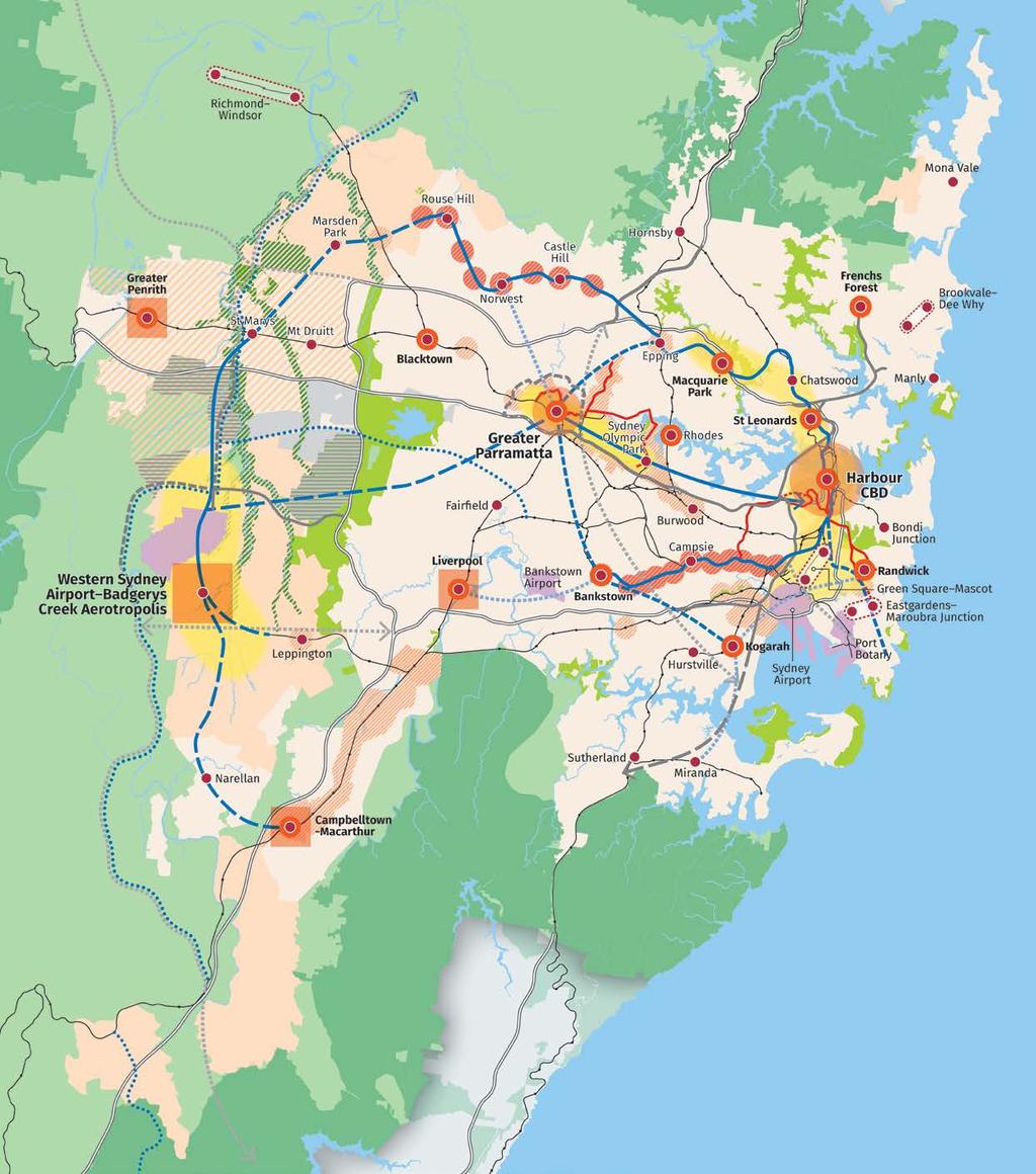
10 10 Spatial elements of the metropolis of three cities Landscape A parkland city, a river city and a harbour city with increased urban tree canopy and a network of open space, framed by a protected natural area. Waterways Metropolitan Rural Area Protected Natural Area and Open Space Vision to 2056 Housing + Great Places An additional 725,000 dwellings creating new communities and urban renewal areas that support new and existing centres and enhance local character. Existing Urban Area Land Release Area Transit Oriented Development Urban Renewal Area Growth Area Investigation Urban Investigation Area


11 11 Jobs Places for 817,000 additional jobs with a strong focus on economic corridors, health and education precincts and strategic centres. Economic Corridor Metropolitan Centre Metropolitan Cluster Health and Education Precinct Strategic Centre Western Sydney Employment Area A metropolis of three cities Connectivity A 30-minute city that connects people to jobs, businesses, schools and services and supports the economic efficiency of trade gateways. Motorway Train Link Train Link Investigation/Visionary Road Investigation/Visionary Freight Rail Investigation Light Rail Trade Gateway NOTE: Committed projects of: Western Harbour Tunnel & Beaches Link, F6 WestConnex to President Avenue Kogarah, Parramatta Light Rail Stage 2 and Sydney Metro West are subject to final business case, no investment decision yet. Routes and stops for some transport corridors/projects are indicative only.
12 12 Structure plan for the metropolis of three cities Bringing the spatial elements together Combined, the spatial elements make up the structure plan for Greater Sydney. The structure plan emphasises how the principal spatial elements are interconnected and integrated to best deliver on the vision of A Metropolis of Three Cities and the aspirations of the 10 Directions. Of critical importance are: the integration of the mass transit network with the economic corridors, centres, transit oriented development, urban renewal and health and education precincts the connectivity between the rail freight and strategic road networks and the trade gateways and industrial areas the integration of the green grid network with residential neighbourhoods the retention of the integrity of the values of the Metropolitan Rural Area and the Protected Natural Area. Metropolitan Centre Metropolitan Cluster Health and Education Precinct Strategic Centre Economic Corridor Trade Gateway Western Sydney Employment Area Land Release Area Transit Oriented Development Urban Renewal Area Greater Penrith to Eastern Creek Growth Area Urban Investigation Area Urban Area Protected Natural Area Metropolitan Rural Area South Creek Parkland Investigation Waterways Train Station Committed Train Link Train Link/Mass Transit Investigation 0 10 years Train Link/Mass Transit Investigation years Train Link/Mass Transit Visionary Freight Rail Investigation Light Rail Light Rail Investigation Motorway Committed Motorway Road Investigation 0 10 years Road Investigation years Road Visionary Major Urban Parkland including National Parks and Reserves
13 13 See overleaf NOTE: Committed projects of Western Harbour Tunnel & Beaches Link, F6 WestConnex to President Avenue Kogarah, Parramatta Light Rail Stage 2 and Sydney Metro West are subject to final business case, no investment decision yet. Routes and stops for some transport corridors/projects are indicative only.

14 14 Metropolitan Centre Metropolitan Cluster Health and Education Precinct Strategic Centre Economic Corridor Trade Gateway Western Sydney Employment Area Land Release Area Transit Oriented Development Urban Renewal Area Greater Penrith to Eastern Creek Growth Area Urban Investigation Area Urban Area Protected Natural Area Metropolitan Rural Area Major Urban Parkland including National Parks and Reserves South Creek Parkland Investigation Waterways Train Station Committed Train Link Train Link/Mass Transit Investigation 0 10 years Train Link/Mass Transit Investigation years Train Link/Mass Transit Visionary Freight Rail Investigation Light Rail Light Rail Investigation Motorway Committed Motorway Road Investigation 0 10 years Road Investigation years Road Visionary NOTE: Committed projects of Western Harbour Tunnel & Beaches Link, F6 WestConnex to President Avenue Kogarah, Parramatta Light Rail Stage 2 and Sydney Metro West are subject to final business case, no investment decision yet. Routes and stops for some transport corridors/projects are indicative only.
15 15

16 16 Western Parkland City vision Infrastructure and collaboration The Western Sydney City Deal will optimise infrastructure and business investment, employment and liveability outcomes. Collaboration Areas at Liverpool, Greater Penrith and Campbelltown-Macarthur will address complexities and coordinate planning, governance and implementation to support growth. Liveability The city will emerge with the development of new neighbourhoods and centres, and with urban renewal close to existing centres. Place-making will help to design neighbourhoods with fine grain fabric and human scale. This will support healthy lifestyles and connected communities. Productivity The designation of the metropolitan cluster recognises the opportunity to build on the strengths of the three established centres and deliver a 30-minute city. The city will include expansive industrial and urban services lands to the north and east of the Western Sydney Airport. Supported by a freight link, these lands will provide for Greater Sydney s long-term freight and logistics and industrial needs. The population of the Western Parkland City is projected to grow from 740,000 in 2016 to 1.1 million by 2036, and to well over 1.5 million by The city will be established on the strength of the new international Western Sydney Airport and Badgerys Creek Aerotropolis. It will be a polycentric city capitalising on the established centres of Liverpool, Greater Penrith and Campbelltown-Macathur. New city-shaping transport and the airport will make the city the most connected place in Australia. The Australian and NSW Governments will deliver the first stage of the North South Rail Link from St Marys to the Western Sydney Airport and Badgerys Creek Aerotropolis. A potential new east-west mass transit corridor will connect the Western Parkland City to the Central River City. In the long term a potential Outer Sydney Orbital will provide the city with direct connections to Greater Newcastle, Wollongong and Canberra. A Western Economic Corridor will attract globally significant defence and aerospace activities and contribute to a strong trade, freight, logistics, advanced manufacturing, health, education and science economy. This will produce knowledge-intensive jobs close to areas of high population growth and drive the development of the corridor and the metropolitan cluster. The city will include housing diversity around centres and transit nodes. A future investigation area from Greater Penrith to Eastern Creek will link existing areas and major infrastructure. The Greater Sydney Green Grid will be a core element of the amenity of the Western Parkland City. Sustainability Development along the spine of South Creek and its tributaries will re-imagine liveability and sustainability, providing new cool and green neighbourhoods and centres with generous open space in a parkland setting. Increased tree canopy cover will provide shade and shelter for walkable neighbourhoods within easy reach of shops and services. The parkland character will be enhanced by the national parks and rural areas framing the city.

17 17 North West Growth Area New neighbourhoods (land release) Industry and urban services Biodiversity protection Western Sydney Parkland Greater Penrith to Eastern Creek Growth Area Investigation Linking new areas to existing communities North South Rail Link St Marys to Western Sydney Airport and Badgerys Creek Aerotropolis South Creek Corridor A cool green corridor through the Western Parkland City Western Economic Corridor New international airport and aerotropolis Defence and aerospace activities Trade, freight, logistics, advanced manufacturing, health, education and science Potential rail connections North South Rouse Hill to St Marys and Badgerys Creek Aerotropolis to Macarthur East West Western Parkland City to Central River City Horsley Park and Mount Vernon Urban investigation area Glenfield to Macarthur Urban renewal South West Growth Area New neighbourhoods (land release) Emerging centres at Leppington and Oran Park Greater Macarthur New communities Menangle, Mount Gilead, Wilton
18 18 Central River City vision Infrastructure and collaboration A shared vision for the Greater Parramatta and the Olympic Peninsula (GPOP) recognises that Greater Parramatta is a central hub which brings to together stakeholders in business, health, education, arts and heritage. The growth infrastructure compact pilot at GPOP will assess growth scenarios that best align land use, infrastructure investment and community benefits. Liveability The population of the Central River City is projected to increase from 1.3 million people to 1.7 million people over the next 20 years. This will transform many parts of the city from a suburban to an urban environment. The city s rich heritage will be preserved and celebrated; cultural events and facilities will continue to improve the city s liveability. Productivity The Central River City will grow substantially capitalising on its location close to the geographic centre of Greater Sydney. Unprecedented public and private investment is contributing to new transport and other infrastructure leading to a major transformation of the Central River City. Greater Parramatta the metropolitan centre is the core of the Central River City. Greater Parramatta encompasses Parramatta CBD, North Parramatta and Westmead and Parramatta Park. Greater Parramatta s economy is centred on world-class health, education and research institutions as well as finance, business services and administration. The Central River City s economy is much broader, with the Greater Parramatta and the Olympic Peninsula Economic Corridor taking in the Westmead health and education precinct; advanced technology and urban service sectors in Camellia, Rydalmere, Silverwater and Auburn; and the Sydney Olympic Park lifestyle precinct. The corridor will be supported by the Parramatta Light Rail. The Sydney Metro West rail link will deliver faster and more efficient transport from the Harbour CBD to Greater Parramatta. Potential radial mass transit/rail services from Greater Parramatta will boost business-tobusiness connections and provide access to a larger skilled labour force to support the growing metropolitan centre. The Sydney Metro Northwest rail link will improve the growth prospects for the north-west of the city by increasing the access to jobs. Economic activity and infrastructure investment will be focused in the Greater Parramatta and the Olympic Peninsula Economic Corridor and supported by the well-established industrial corridor which extends from Villawood to Wetherill Park. Economic activity will be enhanced surrounding Greater Parramatta through investment in links to the surrounding strategic centres, such as Bankstown. Sustainability In the Central River City, the Greater Sydney Green Grid will improve connections to and enhance existing open spaces, particularly along the Parramatta, Duck and Georges rivers and Prospect Reservoir. Large urban renewal areas provide the opportunity to improve sustainability through a precinct-based approach.


19 19 North West Growth Area New neighbourhoods (land release areas) Industrial and urban service lands Biodiversity protection Sydney Metro Northwest Rouse Hill to Chatswood NorthConnex Connecting the M1 and M2 Motorways Greater Parramatta Metropolitan Centre New light rail infrastructure and services New neighbourhoods and urban renewal Parramatta Light Rail Stage 1 Westmead to Carlingford Stage 2 Camellia to Sydney Olympic Park East-West mass transit Potential rail connection Central River City to Western Parkland City Sydney Metro West Fast and frequent connection between Greater Parramatta and Harbour CBD Freight link Potential connection to Western Sydney industrial and urban services land The GPOP Economic Corridor Westmead health and education precinct Urban renewal corridor from Camellia to Carlingford Advanced technology and urban services in Camellia, Rydalmere, Silverwater and Auburn Sydney Olympic Park lifestyle precinct Potential radial mass transit services to Greater Parramatta from: Norwest Epping Bankstown Kogarah


20 20 Eastern Harbour City vision Infrastructure and collaboration Collaboration Areas include health and education precincts at Camperdown-Ultimo, Randwick and Kogarah with collaboration roles at St Leonards, Macquarie Park and Frenchs Forest. Further collaboration to address planning complexities and identify ways to support growth will be undertaken at the Australian Nuclear Science and Technology Organisation innovation precinct and the Bankstown Airport and Milperra industrial area. Liveability The population of the Eastern Harbour City is projected to grow from 2.4 million people in 2016 to 3.3 million people by The Eastern Harbour City is a mature mix of well-established communities, from traditional suburban neighbourhoods to Australia s most highly urban areas. Growth will bring urban renewal with increased infrastructure and services, open spaces and public places. Sympathetic infill development will focus on improved local connections. The Eastern Harbour City has Australia s global gateway and financial capital, the Harbour CBD, as its metropolitan centre. Well-established, well-serviced and highly accessible by its radial rail network, it has half a million jobs and the largest office market in the region. The Eastern Harbour City has significant rail projects underway to increase its global competitiveness, boost business-to-business connections and attract skilled workers with faster commuting times. The Sydney Metro Northwest links Rouse Hill to Chatswood, Sydney Metro City & Southwest connects Chatswood to Sydenham-Bankstown and Sydney Metro West will provide faster and more frequent trips to and from Greater Parramatta. The CBD and South East Light Rail connects the Harbour CBD to the Randwick health and education precinct. The Eastern Economic Corridor from Macquarie Park to Sydney Airport is the State s greatest economic asset contributing two-thirds of NSW s economic growth in the financial year. It will build on its credentials and leverage its strong financial, professional, health, education and innovation sectors. The Harbour CBD will focus on innovation and global competitiveness to underpin its continued growth. It will extend its capabilities with an emerging Innovation Corridor on its western edge comprising universities, a major teaching hospital, international innovation companies and fastgrowing start-ups. Productivity Innovation and global competitiveness will be focussed in the Harbour CBD, the Eastern Economic Corridor and strategic centres. These will be supported by investments in transport and services, jobs growth and business activity. Retention and management of industrial and urban service land will enable the growth of nationally significant, and locally important businesses and services. Sustainability The Greater Sydney Green Grid will improve access to foreshores, waterways and the coast for recreation, tourism, cultural events and water-based transport.


21 21 Eastern Economic Corridor Macquarie Park Chatswood St Leonards Harbour CBD Green Square-Mascot Randwick Sydney Airport Northconnex Connecting the M1 and M2 Motorways Sydney Metro Northwest Rouse Hill to Chatswood Urban renewal at Macquarie Park and Epping Harbour CBD Metropolitan centre Global financial, professional, health, education and innovation sectors 500,000 jobs Innovation Corridor Sydney Metro West Fast and frequent connections between Harbour CBD and Greater Parramatta CBD and South East Light Rail Connecting Randwick health and education precinct to Harbour CBD Sydney Metro City & Southwest Chatswood to Sydenham and Bankstown Urban renewal Crows Nest, St Leonards, Waterloo and Sydenham to Bankstown
22 22 Ten Directions for the metropolis of three cities A liveability, productivity and sustainability framework Delivering and monitoring the Plan objectives and indicators Directions A city supported by infrastructure Infrastructure supporting new developments A collaborative city Working together to grow a Greater Sydney A city for people Celebrating diversity and putting people at the heart of planning Housing the city Giving people housing choices A city of great places Designing places for people Potential indicator* Potential indicator: Increased 30-minute access to a metropolitan centre/cluster Potential indicator: Increased use of public resources such as open space and community facilities Potential indicator: Increased walkable access to local centres Potential indicators: Increased housing completions (by type); Number of councils that implement Affordable Rental Housing Target Schemes Potential indicator: Increased access to open space Objectives Objective 1: Infrastructure supports the three cities Objective 2: Infrastructure aligns with forecast growth growth infrastructure compact Objective 3: Infrastructure adapts to meet future needs Objective 4: Infrastructure use is optimised Objective 5: Benefits of growth realised by collaboration of governments, community and business Objective 6: Services and infrastructure meet communities changing needs Objective 7: Communities are healthy, resilient and socially connected Objective 8: Greater Sydney s communities are culturally rich with diverse neighbourhoods Objective 10: Greater housing supply Objective 11: Housing is more diverse and affordable Objective 12: Great places that bring people together Objective 13 : Environmental heritage is identified, conserved and enhanced Objective 9: Greater Sydney celebrates the arts and supports creative industries and innovation *Indicators will be developed in consultation with State and local government to optimise regional, district and local monitoring programs (refer to Objective 40).
23 23 A well-connected city Jobs and skills for the city A city in its landscape An efficient city A resilient city Developing a more accessible and walkable city Creating the conditions for a stronger economy Valuing green spaces and landscape Using resources wisely Adapting to a changing world Potential indicators: Percentage of dwellings located within 30 minutes by public transport of a metropolitan centre/ cluster; Percentage of dwellings located within 30 minutes by public transport of a strategic centre Potential indicator: Increased jobs in metropolitan and strategic centres Potential indicators: Increased urban tree canopy; Expanded Greater Sydney Green Grid Potential indicators: Reduced transportrelated greenhouse gas emissions; Reduced energy use per capita Potential indicator: Number of councils with standardised statewide natural hazard information Objective 14: A Metropolis of Three Cities integrated land use and transport creates walkable and 30-minute cities Objective 15: The Eastern, GPOP and Western Economic Corridors are better connected and more competitive Objective 16: Freight and logistics network is competitive and efficient Objective 17: Regional connectivity is enhanced Objective 18: Harbour CBD is stronger and more competitive Objective 19: Greater Parramatta is stronger and better connected Objective 20: Western Sydney Airport and Badgerys Creek Aerotropolis are economic catalysts for Western Parkland City Objective 21: Internationally competitive health, education, research and innovation precincts Objective 22: Investment and business activity in centres Objective 23: Industrial and urban services land is planned, retained and managed Objective 24: Economic sectors are targeted for success Objective 25: The coast and waterways are protected and healthier Objective 26: A cool and green parkland city in the South Creek corridor Objective 27: Biodiversity is protected, urban bushland and remnant vegetation is enhanced Objective 28: Scenic and cultural landscapes are protected Objective 29: Environmental, social and economic values in rural areas are protected and enhanced Objective 30: Urban tree canopy cover is increased Objective 31: Public open space is accessible, protected and enhanced Objective 32: The Green Grid links parks, open spaces, bushland and walking and cycling paths Objective 33: A low-carbon city contributes to net-zero emissions by 2050 and mitigates climate change Objective 34: Energy and water flows are captured, used and re-used Objective 35: More waste is re-used and recycled to support the development of a circular economy Implementation Objective 36: People and places adapt to climate change and future shocks and stresses Objective 37: Exposure to natural and urban hazards is reduced Objective 38: Heatwaves and extreme heat are managed Objective 39: A collaborative approach to city planning Objective 40: Plans refined by monitoring and reporting

24 24 1 About the Plan The Greater Sydney Region Plan (the Plan), A Metropolis of Three Cities: sets a 40-year vision (to 2056) and establishes a 20-year plan to manage growth and change for Greater Sydney in the context of social, economic and environmental matters informs district and local plans and the assessment of planning proposals assists infrastructure agencies to plan and deliver for growth and change and to align their infrastructure plans to place-based outcomes informs the private sector and the wider community of the growth management and infrastructure investment intentions of government. The Plan applies to the Greater Sydney Region, shown in Figure 2, and sets the planning framework for the five districts which make up the region. The local government areas that make up the five districts are listed in Figure 2. Integrated planning A Metropolis of Three Cities integrates land use, transport and infrastructure planning between the three tiers of government and across State agencies. The Plan has been prepared concurrently with Future Transport 2056 and State Infrastructure Strategy to align land use, transport and infrastructure outcomes for Greater Sydney for the first time in a generation. The transport initiatives in this Plan are sourced from Future Transport They are in four categories: committed, investigation 0 10 years, investigation years and visionary 20+ years. The latter three categories require further investigation and ultimately decisions of government on commitments to funding. The Plan outlines how the 10 Directions established in Directions for a Greater Sydney are the starting point for delivering integrated planning and how this alignment moves from setting directions to implementing directions. This relationship is shown in Figure 1. Figure 1: State plans working together for Greater Sydney


25 25 Figure 2: Greater Sydney Region See inset Region Boundary District Boundary Local Government Area Waterways DISTRICTS Central City Eastern City North South Western City Blacktown, Cumberland, Parramatta, The Hills Bayside, Burwood, Canada Bay, City of Sydney, Inner West, Randwick, Strathfield, Waverley, Woollahra Hornsby, Hunter s Hill, Ku-ring-gai, Lane Cove, Mosman, North Sydney, Northern Beaches, Ryde, Willoughby Canterbury Bankstown, Georges River, Sutherland Blue Mountains, Camden, Campbelltown, Fairfield, Hawkesbury, Liverpool, Penrith, Wollondilly
26 26 About the Plan Requirements of the Plan The Plan has been prepared in accordance with section 3.3 of the Environmental Planning and Assessment Act 1979 which requires it to include or identify: the basis for strategic planning in the region, having regard to economic, social and environmental matters; a vision statement; Objectives consistent with that vision; Strategies and Actions for achieving those Objectives; and an outline of the basis on which the implementation of those Actions will be monitored and reported. In line with legislative requirements, a review of the current regional plan for Greater Sydney, A Plan for Growing Sydney (2014) identified that while most of the directions in A Plan for Growing Sydney were still relevant, they required updating or strengthening to respond to new challenges for planning Greater Sydney to The review is available on the Greater Sydney Commission s website at The Plan complements existing Australian and NSW Government requirements for managing growth and change across Greater Sydney such as State environmental planning policies and the Heritage Act 1977 (NSW). The Greater Sydney Commission, through the Greater Sydney Commission Act 2015, is responsible for leading metropolitan planning for the Greater Sydney Region and, at the request of the Minister for Planning, engaged with the Greater Sydney community and prepared a draft Greater Sydney Region Plan. Giving effect to the Plan Give effect to is the legislative term for delivering the regional and district plans through local plans. Opportunities to coordinate and realise greater efficiencies in the implementation of plans have been made possible by recent planning reforms that include a legislative framework for strategic planning. This framework provides a clear line of sight from the regional level to planning and delivery at the local level. The common requirement for the plans to identify their basis having regard to economic, social and environmental matters and for monitoring and reporting creates the opportunity to improve the integration of data and analysis that informs transparent decision-making and evaluation across all three spatial levels of planning. A key component of this framework is the local strategic planning statement, which leads the local response to the higher-level changes and trends, and must be consistent with any strategic plan for the area as set out in the Environmental Planning and Assessment Act The local strategic planning statement is also required to be consistent with a council s community strategic plan prepared under the Local Government Act Local planning is supported by NSW Government funding for implementation and infrastructure. This includes funding that accelerates planning processes for a selection of councils and state infrastructure funding programs that align to growth (refer to Objective 39). In finalising the Plan, the Greater Sydney Commission used its independence to engage consistently and transparently with the community, businesses, councils, and State agencies throughout the process. Region Plan District Plan Local Strategic Planning Statement Community Strategic Plan The Plan incorporates feedback from community and stakeholder engagement including submissions to the draft Greater Sydney Region Plan exhibited from 22 October 2017 to 15 December 2017 and five revised draft District Plans exhibited from 26 October 2017 to 15 December Submission reports on the draft regional plan and the draft district plans are available on the Greater Sydney Commission s website at The relationship of the plans and their implementation is further discussed in Chapter 7.
27 27 2 Past, present and future Greater Sydney has grown from the home of Aboriginal peoples to an internationallysignificant economic metropolis. In the past 25 years, it has grown by 1.3 million to reach 4.7 million people (refer to Figure 3). Its evolution, through population growth, urbanisation and technological advances, can be traced through eight major planning strategies since A Metropolis of Three Cities represents another quantum shift in driving Greater Sydney s future as a successful economy and one of the world s most beautiful and liveable places. In looking to the future, many of the lessons of the past remain relevant today. Greater Sydney s past Rapid population growth in Greater Sydney by the turn of the 20 th century, led to the 1909 Royal Commission for the Improvement of the City of Sydney and its Suburbs. Its emphasis was on providing basic sanitation and improved living standards for the working class, and to beautify the city. At the time, growth followed the tram and rail corridors. The 1948 County of Cumberland Plan moved families from inner-city slums to the west, along new rail lines radiating from what is now the Eastern Harbour City, and established the first green belt. Post-war immigration, the baby boom and falling household occupancy rates were addressed in the 1968 Sydney Region Outline Plan which promoted Figure 3: Greater Sydney Region population growth and metropolitan planning

28 28 Past, present and future new centres within the metropolitan area, each planned for growth along road and rail corridors. It embraced connections to Newcastle and Wollongong and had a stronger focus on the areas this Plan refers to as the Central River and Western Parkland cities. Four subsequent plans Sydney into its Third Century (1988), Cities for the 21st Century (1995), City of Cities (2005) and A Plan for a Growing Sydney (2014), differed from the earlier plans by focusing on economic issues, as well as the physical form of growing a polycentric city and urban renewal. The 1988 Plan was designed in collaboration with a transport strategy and was the first to recommend higher development densities in established and greenfield areas, a policy that continues to evolve, and saw development densities in greenfield areas increase from eight lots per hectare in 1988 to close to 20 lots per hectare today. The 1988 plan included a new airport in Greater Sydney s West, reinstated in the 2014 plan, and was the first to introduce sub-regional (district) planning together with a strong focus on urban design. The 2005 and 2014 plans continued to refine the framework of Greater Sydney as a series of sub-regions and promote the role of centres across Greater Sydney. Greater Sydney s present Greater Sydney s most pressing challenge today is to address population growth and demographic change, while improving liveability. For most of the 20 th century, Greater Sydney s population grew at an annual rate of around 2.5 per cent (refer to Figure 4). Today, Greater Sydney is one of the top 10 fastestgrowing regions in the Western world and by 2036 is projected to be home to another 1.7 million people, or 3.2 million more people by Greater Sydney s footprint has grown not only through an increasing population, but a decline in dwelling occupancy rates; down from 5.24 and 6.08 people per dwelling in 1909 (depending on whether the resident lived in the suburbs or the city) to an average of 2.8 in Density has declined from 13 people per hectare in 1909 to an average of 4.25 people per hectare across Greater Sydney. While there are 31 people per hectare in the Eastern Harbour City, this is low compared to an average density of 109 per hectare across New York City (the five boroughs). Figure 4: Greater Sydney Region annual population growth rates at past regional plan and forecast dates
29 29 In addition, Greater Sydney is currently seeing a higher number of births, with around 63,500 births each year. At the other end of the spectrum, the proportion of over-85s will almost triple in the next 25 years. These two statistics alone generate the need for greater housing choice and affordability as well as community facilities from baby health care, child care and schools, to support services for older people. Greater Sydney s housing market today is recognised as one of the most expensive in the world with median detached dwelling prices exceeding $1 million and reaching 10.5 times the median annual household income. This is driving a change in expectations from the quarter-acre block (about 1,000 square metres) of the 1948 and 1968 plans to smaller lots with compact and innovative forms of housing. The Eastern Harbour and Central River cities are increasingly attractive for inner-city living, with higher densities bringing greater vibrancy, reduced travel times and economic opportunities. While the 1909 Commission sought to improve equity and living standards for workers by moving them to suburban areas along transit corridors, today more opportunities for people to live closer to their jobs are needed: more affordable homes and better access to educational opportunities in each of the three cities. Approaches to connecting the city have also changed and, arguably, have come full circle since the 1909 Commission found: The only effective method of dealing with this rapidly growing traffic lies in the construction of the City and Suburban railway systems (refer to Figure 5). Today, rail systems need to be expanded to better serve the three cities, particularly the Western Parkland and Central River cities, and ways need to be found to accommodate new travel modes and technologies such as drones, electric and autonomous vehicles. Just as in 1948, when Greater Sydney was challenged to provide sewerage, public transport, schools or nearby jobs for the rapidly growing city, providing infrastructure remains a challenge today. Development needs to be sequenced so that adequate infrastructure can be funded and delivered. The growth of Greater Parramatta as a Central Business District was first mooted by the 1968 plan, reinforced in the 1988 plan and confirmed by the 2005 plan and is now the focus of the Central River City. Together with the emergence of the Western Parkland City and the reinforcement of the Eastern Harbour City, Greater Sydney will become a more equitable and connected city that makes the most effective use of its infrastructure. A polycentric city is supported by a centres policy which reinforces an objective of the 2005 plan, that close to half of all Greater Sydney s jobs are to be in major centres. Centres across Greater Sydney need to be supported by sufficient industrial and urban services land, also consistent with the 1988, 1995 and 2005 plans. Every plan since 1909 has sought to beautify the region through good quality design and the protection of natural assets, enhancing cultural, historic and natural icons, from Sydney Harbour to the Blue Mountains and Scenic Hills, while reinforcing the quality of public spaces such as Parramatta s Civic Square and Circular Quay. Building on the green web of 1948, the Greater Sydney Green Grid includes re-envisaging Prospect Reservoir for tourism and greater leisure activities; revitalising the waterways of the Western Parkland City around South Creek; and recognising the importance of tree canopy for visual appeal and for managing heat, particularly in the western part of the region where it can be over seven degrees hotter than in the eastern part of the region.

30 30 Past, present and future Figure 5: Transport investment in Greater Sydney Source: Transport for NSW Greater Sydney s future Rapid technological change is inevitable, particularly around key areas of access and mobility and in creating a lower carbon future. Electric and autonomous vehicles, robotics, drones, artificial intelligence, battery storage, automation, computing speed and device connectivity will change how residents live and, in turn, the shape of the region. Technology may also increase demand for local employment hubs, or shared office spaces, to support localised production through developments such as 3D printing. There may be on-demand bus services, and the sharing of vehicles, smartphonebased bike sharing, autonomous vehicle hubs and electric charging stations. The economy may also change with a greater reliance on knowledge-intensive jobs and tertiary education, particularly in the fields of science, technology, engineering and mathematics (referred to as STEM). Already, education and health care are significant growth precincts. The gig economy a labour market characterised by the prevalence of short-term contracts or freelance work as opposed to permanent jobs may grow, potentially shifting traditional workplace and commuting patterns as a greater number of the workers are based at home. In aged care and health services, robots may increasingly take the load of routine tasks so workers can concentrate on engagement and patient care. The future will require people to adapt to climate change, to mitigate future impacts and to be more efficient with resources. Infrastructure will need to be not only resilient but adaptable to technological transformation such as renewable energy, smart energy networks, distributed energy and water systems and energy-efficient homes and buildings. Development will need to better capitalise on air rights rather than making space by expanding the urban footprint. This will not only require good quality apartment buildings and commercial towers but mixed-use buildings including schools, roof top gardens, vertical farms and innovative energy sources. Some things stay the same While population growth, urbanisation and technologies change, many things stay the same the importance of well-located housing, beautiful public places, efficient transport, local infrastructure and planning that is people focused. A Metropolis of Three Cities continues the strong legacy of strategic metropolitan planning. It seeks to protect what people love about Greater Sydney and safeguard opportunities for future generations.
, Eastern Beaches, North Sydney and Inner West")
31 31 Greater Sydney s changing urban form: Most of the urban area comprises detached low density housing on suburban quarter-acre blocks (about 1,000 square metres) with some medium density and semi-detached housing in the inner suburbs; higher density dwellings limited to city east (Potts Point/Kings Cross/ Darlinghurst/Surry Hills), Eastern Beaches, North Sydney and Inner West 2016 Density has increased across the urban area; in the central and eastern areas the traditional quarter-acre block has diminished in size; more intense development is evident from the City of Sydney to Mascot and in Parramatta, Chatswood, Rhodes, Strathfield, Burwood and Hurstville; some increase in centres along the Western, Bankstown and Illawarra rail lines and in Hornsby and Liverpool 2036 Little change in the outward spread; increase in intensity of development within existing centres and the existing urban area Source: Australian Bureau of Statistics Census and NSW Department of Planning and Environment dwelling forecasts Note: Data based on Australian Bureau of Statistics SA2s; but due to small geographies, unable to identify changes in land release areas


32 32 3 Infrastructure and collaboration Directions for infrastructure and collaboration A city supported by infrastructure Potential indicator: Increased 30-minute access to a metropolitan centre/cluster Providing adequate infrastructure to support population growth is essential to creating strong communities. One mechanism to better align growth with infrastructure is the growth infrastructure compact which would assess the nature, level and timing of infrastructure required for an area in light of its forecast housing and employment growth, including analysis of growth scenarios. This approach would demonstrate the correlation between growth and infrastructure, such as public transport, schools and open space, to allow for timely integration and more effective expenditure on infrastructure by location. The sequencing, optimising and adaptability of infrastructure are also considered as part of managing infrastructure delivery with growth. A collaborative city Potential indicator: Increased use of public resources such as open space and community facilities Managing the competing needs of a city requires all levels of government, industry and the community to work together. This is particularly important as development pressures grow. Collaboration between government, industry and local communities will result in the best use of resources such as public spaces, school ovals and community facilities. Communities will be involved in planning for their local infrastructure and services.
33 33 3 Infrastructure and collaboration Past plans for Greater Sydney have been successful in creating additional capacity for housing, employment and population growth. With continuing strong population growth and the current strength in the housing market, it has become viable to develop across a broader section of Greater Sydney. This has resulted in unprecedented levels of housing development which is increasing the demand on infrastructure and services across the region. In tandem, community standards for the quality and timely provision of infrastructure, amenity and place have also increased. As Greater Sydney grows and becomes more complex there is a need to design better ways of supporting growth and delivering appropriate infrastructure in the right places. This would give the community confidence that the region is being planned and developed responsibly and sustainably. It is imperative that growth is supported by essential services, such as education and health. An integrated planning approach also enables job creation opportunities across Greater Sydney to be maximised. As a starting point, the Greater Sydney Region Plan outlines when and where growth is anticipated or planned across the three cities. This includes housing targets and identified Planned Precincts and Growth Areas. The NSW Government is a major contributor to much-needed housing supply through the Planned Precincts and Growth Areas programs. Housing supply is also supported by the acceleration of council-led rezonings, faster housing approvals, delivery and renewal of social housing and using surplus government lands. Planned Precincts will be consistent with the Objectives and Strategies of the Plan and relevant District Plans to enhance liveability, productivity and sustainability. These precincts will be designed and delivered in collaboration with councils and informed by key State agencies and their asset plans. This planning will be supported by a Special Infrastructure Contribution or similar arrangement to help fund the delivery of essential community infrastructure such as health, schools, open space and roads. The key role of A Metropolis of Three Cities is to co-ordinate a whole-of-government approach that can provide the appropriate infrastructure in the right places to support the growth of three cities. In partnership with Future Transport 2056 and State Infrastructure Strategy , the Plan is critical in providing the basis for this collaborative approach. This can align policy and investment directions for business and the community. To achieve this new methodical, proactive and collaborative approach, the Plan sets out four overarching Objectives to improve the planning and provision of infrastructure across Greater Sydney as it grows and evolves (refer to Figure 6). These Objectives are supported by new and refined Strategies for implementation, in collaboration with Infrastructure NSW, State agencies and councils. A whole-of-government common platform and source of data including fiscal, population, demographic and employment planning assumptions informs long-term strategic planning and the preparation of business cases for infrastructure.
34 34 Infrastructure and collaboration Context The Plan also introduces the concept of Collaboration Areas that focus on creating great places particularly as centres of economic productivity. The responsibility for delivering great places does not rest with any one organisation, as barriers to growth can be multi-faceted and complex. As a non-statutory initiative, Collaboration Areas offer a new way for Australian, NSW and local governments to work to deliver collective responses that support growth and change. This will be undertaken by identifying and aligning the activities and investments of the three tiers of government and key stakeholders, based on evidence, to respond to the unprecedented levels of growth and investment in Greater Sydney. The outputs of the collaborations are a series of strategies tailored to an area, that provide certainty to the community and the private sector, and align the Government s investment and policies to achieving great places. Summary of Actions The following metropolitan-wide Action will deliver infrastructure and collaboration objectives. 1. Identify, prioritise and deliver Collaboration Areas (refer to Objective 5). 2. Coordinate land use and infrastructure for the Western City District (refer to Objective 5). Figure 6: Strategies to align infrastructure with a growing city Vision refer to Objective 1 Prioritising infrastructure investment to support the three cities an equitable home to 8 million residents in 2056 Process refer to Objective 2 Aligning forecast growth with infrastructure growth infrastructure compact simultaneously delivering housing and infrastructure Funding and financing infrastructure who pays and contributes to growing Greater Sydney Sequencing infrastructure with growth taking a methodical and sequenced approach Implement and manage refer to Objectives 3 and 4 Designing infrastructure to be adaptable future-proofing assets Asset management of infrastructure getting more out of existing assets

35 35 A city supported by infrastructure Objective 1 Infrastructure supports the three cities A Metropolis of Three Cities provides the spatial foundation for more effective and efficient planning for city-shaping infrastructure and enhanced utilisation of infrastructure. The three-city metropolis vision moves away from the historical radial focus on the Eastern Harbour City to a new focus requiring more interconnections within each city and between the three cities. This will facilitate greater opportunities for learning, labour participation, industry growth and development, and access to housing and services across Greater Sydney and create a 30-minute city. This critical spatial shift will transform future infrastructure plans by providing a specific approach to the infrastructure needs, timing and response required for each city. While each of the three cities will require new infrastructure, the focus will vary according to: existing infrastructure and services, capacity and industry and housing activity existing levels of committed investment the time scale of development. For example, the Eastern Harbour City has a significant rebuilding program in place, together with initiatives to make better use of existing assets and adapt them to new technologies (refer to Objective 18). The Central River City is also undergoing a rebuilding program in a high-growth environment which requires existing infrastructure to be optimised (refer to Objective 19). Major new infrastructure will be required for the Western Parkland City, where the focus will be on planning growth and sequencing new infrastructure and services to support shaping a new connected city (refer to Objective 20). A Metropolis of Three Cities must form the basis of future infrastructure decisions if future investment is to better connect the three cities as well as support major economic drivers such as: digital technology, providing international gateways for business interactions transport services, enabling the movement of goods and labour participation the location and timing of critical support infrastructure, such as health and education facilities for job creation and agglomeration benefits. To deliver a 30-minute city, connections to existing infrastructure in all the three cities need to be improved. Importantly, transport corridors and locations for new centres need to be safeguarded for future infrastructure investments. Planning decisions need to support new infrastructure in each city including cultural, education, health, community and water infrastructure to fairly balance population growth with infrastructure investment. Decisions are required to equitably enhance local opportunities, inclusion and connection to services. In this way infrastructure provision can move from a focus on network-based services to a place-based service approach. Strategy 1.1 Prioritise infrastructure investments to support the vision of A Metropolis of Three Cities. Strategy 1.2 Sequence growth across the three cities to promote north-south and east-west connections.

36 36 Infrastructure and collaboration A city supported by infrastructure Objective 2 Infrastructure aligns with forecast growth growth infrastructure compact A Metropolis of Three Cities identifies areas that are forecast to experience significant residential and employment growth. These areas will require new and/or enhanced local and regional infrastructure to support growth. Many of these areas have existing infrastructure challenges. To better understand, plan for and address these challenges as well as new ones, this Plan introduces a new approach, being piloted by the Greater Sydney Commission, known as a growth infrastructure compact (refer to Figure 7). A growth infrastructure compact aims to: model the growth potential of an area and explore scenarios for its long-term future encourage openness about the range of infrastructure and services needed to grow an area, the costs involved and how this could feasibly be funded stage growth by being selective about where, when and what to invest in to deliver successful areas make the roll-out of new areas more certain, cost effective and easier to understand for investors, developers and the local community. The growth infrastructure compact approach differs from existing approaches. It would enable a broader level of collaboration and a place-based business case, using a triple-bottom-line methodology to determine the necessary level of investment to support an appropriate growth scenario. Input from all infrastructure agencies would be critical to the process. This approach would lead to an infrastructure delivery plan that is co-designed and co-delivered by State and local governments together with industry. Figure 7: Growth infrastructure compact In this way, growth infrastructure compacts assess the nature, level and timing of the infrastructure investment required for an area, by considering its forecast housing and employment growth, and analysing growth scenarios. A growth infrastructure compact is based on a series of questions such as: To what extent can investment in existing infrastructure be maximised? To what extent does this infrastructure need to be enhanced, extended, embellished or replaced? What new infrastructure is required to support various growth scenarios? How would this work with agency programs and priorities?
37 37 Align growth with infrastructure A growth infrastructure compact would model the best outcome by location and compare this across Greater Sydney. This would provide a tool to determine the most effective and appropriate locations for growth, taking into consideration a wide range of variables within a local context. Taken together, growth infrastructure compact locations could have the potential to form a set of priority locations that inform city-wide planning. This innovative approach is being piloted in the Greater Parramatta and the Olympic Peninsula (GPOP) area (refer to Objective 5). The outcomes of the pilot will potentially inform government on how the growth infrastructure compact could provide an important benchmark for understanding the relative costs and benefits of new development. These benchmarks would provide regional and district planning activities with a greater understanding of potential infrastructure priorities and planning decisions. In delivering on the growth infrastructure compact initiative, existing Planned Precincts and Growth Areas will be unaffected. Across Greater Sydney significant areas have already been committed to growth and change. At the same time the NSW Government is allocating unprecedented levels of investment in transport, education and health (refer to Figure 8). This is alongside investment in arts and cultural facilities across the region. However, there is room to better align growth with infrastructure by identifying place-based infrastructure priorities. This would take into account the capacity of existing infrastructure and existing infrastructure commitments and programs such as Special Infrastructure Contributions, affordable housing initiatives, social housing programs and augmentation of utilities. The growth infrastructure compact could also provide greater context for coordination with infrastructure delivered by local governments. In time, and as appropriate, this approach could be expanded to include local infrastructure requirements. Fund and finance infrastructure Resources are finite so infrastructure investments need to be prioritised to deliver maximum benefits to the community. Even with the potential to improve decision-making through growth infrastructure compacts, multiple sources of funding are required to cover the cost of new infrastructure across Greater Sydney. Many sources of funds are in place already, including funding from consolidated revenue and asset recycling, user charges, contributions from local developments, voluntary planning agreements, council rates and private investment. The NSW Government is investigating Special Infrastructure Contributions in Planned Precincts to fund critical infrastructure. Many funding sources are provided via contributions from development. Development needs to support the funding of infrastructure at an appropriate level, but should not be unreasonably burdened to the extent that projects become unviable. Part of the solution could rely on growth infrastructure compacts identifying the most costeffective locations for growth, based on existing and future infrastructure capacity. Another part of this solution relates to industry and governments being certain of cumulative development costs. There is a need for guidance to address the cumulative impacts of development contributions on development feasibility and delivery across Greater Sydney. Established cost-recovery mechanisms for infrastructure can operate alongside other major project value-sharing mechanisms. Value sharing involves identifying and raising funds additional to those from business-as-usual development activities. Value-sharing assessments should be undertaken as part of the business case development process. While value sharing may provide a useful contribution to project funding, it will not form a major part of the funding equation in most cases. It is important to recognise that value sharing and other cost recovery mechanisms contribute to only a part of the funding required for infrastructure delivery. The majority is still funded by the NSW Government.

38 38 Infrastructure and collaboration A city supported by infrastructure Figure 8: Existing infrastructure investment in Greater Sydney Sydney Metro Road Upgrade Cultural investment B-Line Northern Beaches NorthConnex/WestConnex Trade Gateway Train Station Sydney Metro West Station Beaches Link Tunnel Light Rail Education investments Western Harbour Tunnel Light Rail Committed Health investments Source: NSW State Budget
39 39 Several infrastructure funding mechanisms are sourced from State and local governments. While the Government is presently investing at unprecedented levels in Greater Sydney s infrastructure, many councils are limited in their ability to invest in infrastructure and its maintenance, within the current settings for council rates and development contributions for local infrastructure. Accordingly, there is a need to continue to work within fiscal limits and manage community expectations for infrastructure while achieving objectives to create great places and support growing communities (refer to Chapter 4). There is also a need to consider broader multijurisdictional impacts. One approach could be to expand the scope of infrastructure that is subject to development contributions, however, this expense could create a greater burden on the development sector and ultimately hinder development, which is not in the interest of Greater Sydney. Planning for infrastructure therefore needs to: balance requirements to fund infrastructure without burdening private development unreasonably, by better understanding the cumulative impacts of development contributions in different markets across Greater Sydney explore and, where appropriate, trial opportunities to share value created by the planning process and infrastructure investment (such as rail) to assist the funding of infrastructure increase collaboration with the private sector to finance infrastructure better leverage capacity and the efficiency of existing infrastructure investigate the potential of further user charging to support infrastructure delivery explore and implement new delivery models to improve services to the community. Closely aligning land use and infrastructure planning at the earliest stages enables infrastructure to be delivered efficiently by relevant government and private sector processes to meet the needs of Greater Sydney s growing population. Sequence infrastructure with growth No matter what the provisions for funding and financing infrastructure, it is not possible to cover the cost of new or improved infrastructure across the entire region simultaneously. This can create challenges for State and local governments to meet the demands of growth at the same time as maintaining ageing infrastructure. Effectively aligning infrastructure with growth requires a methodical and sequenced approach to development. It requires a whole-of-government approach and a place-based understanding of sequencing of infrastructure delivery. This enables planning to support infrastructure alignment with areas of growth and transformation before additional areas are rezoned and ready for development. This new approach supports the appropriate growth and infrastructure being provided at the right time. At a district or regional level it could provide valuable context for decision-making. The Greater Sydney Commission s governance frameworks including the Infrastructure Delivery Committee (comprising key State agencies including Health, Education, Transport, Treasury and Planning) enable planning that will best align growth with the provision of infrastructure. Using insights from growth infrastructure compact assessments, the Commission via its Infrastructure Delivery Committee provides advice to the NSW Government on the sequencing of development. Strategy 2.1 Align forecast growth with infrastructure. Strategy 2.2 Sequence infrastructure provision across Greater Sydney using a place-based approach.

40 40 Infrastructure and collaboration A city supported by infrastructure Objective 3 Infrastructure adapts to meet future needs Infrastructure to support Greater Sydney needs to be designed to adapt and transition with technological changes and mega trends 1. For example: design transport and infrastructure that responds to demands for use design places for electric vehicle recharging and to accommodate decentralised utilities adjust city management to changing lifestyles and preferences promote digital technology to improve the provision of services design car parks and drop-off bays that can be adapted to alternative uses (commercial uses, storage, logistics hubs, depots or community uses) in the event that autonomous vehicles reduce the requirements for car parking support virtual high schools using computer technology for accessing selective strands of education such as English, Mathematics and Science that are not available locally. Infrastructure can become more productive from innovative technologies delivering new operating and maintenance solutions. Recent innovations in digital technologies, such as remote sensing, advanced analytics, autonomous operations, and integrated scheduling and control mean that traditional bricks-and-mortar infrastructure can now be used more effectively, and operated and maintained more efficiently. Digital-led business models are likely to disrupt today s services and infrastructure. Therefore, infrastructure needs to be planned to be responsive to change. This includes improvements in efficiencies in logistics and freight through global supply chain integration of physical and communications systems. Flexible designs and agreements for shared use provide new opportunities for social infrastructure including sportsgrounds, performing arts centres and gallery spaces, meeting rooms, schools and community facilities as well as car sharing and carpooling initiatives that can be adapted for use by a cross-section of the community. As technologies evolve, a precinct-based approach to community and public infrastructure, including car parking, needs to be taken to maximise adaptability, access and utilisation. Strategy 3.1 Consider the adaptability of infrastructure and its potential shared use when preparing infrastructure strategies and plans. Electric car charging station.

41 41 Objective 4 Infrastructure use is optimised Operating within appropriate fiscal limits means maximising existing infrastructure assets. Achieving better utilisation of existing assets increases infrastructure capacity to better support communities and has the potential to minimise or avoid the need to fund additional infrastructure. Before implementing new infrastructure responses, the demands on existing infrastructure need to be evaluated and managed. This can be achieved by exploring opportunities to: adopt new technologies such as smart traffic management systems and real-time energy and water metering systems use land more efficiently by co-locating services, or by allocating road space to support increased mass transit services change user behaviours by flexible pricing and other policies develop and implement travel plans to encourage the use of sustainable transport choices. To maximise asset utilisation, new precincts and new developments need to incorporate demand management, and where appropriate, be sequenced to be contiguous with existing developments so that existing demand management initiatives can be extended. Improved asset planning calls for place-based infrastructure investment that achieves higher levels of social, economic and environmental outcomes. Current planning and appraisal processes tend to emphasise infrastructure as discrete, sectorspecific assets. This creates barriers to identifying and exploiting potentially valuable place-based interdependencies. Similarly, these approaches are unable to identify potentially hazardous and costly interdependencies in a systemic manner. A functional transit corridor, for example, should incorporate essential utilities such as digital connectivity and energy. Light rail carriage. This approach reinforces the need for a place-based assessment of infrastructure through measures such as growth infrastructure compacts where scenario testing is used to identify key inter-relationships, triggers and thresholds in the sequencing of land use change and infrastructure delivery. A major challenge for providers of infrastructure is to realise the innovative opportunities in placebased interdependencies, and so increase value for money, sustainability and resilience. It is necessary to recognise that real-world infrastructure systems are highly interconnected, both with each other and with the socio-economic and natural systems in which they are located. Strategy 4.1 Maximise the utility of existing infrastructure assets and consider strategies to influence behaviour changes, to reduce the demand for new infrastructure, including supporting the development of adaptive and flexible regulations to allow decentralised utilities.

42 42 Infrastructure and collaboration A collaborative city A collaborative city Objective 5 Benefits of growth realised by collaboration of governments, community and business Collaboration between the three tiers of government and across State agencies is essential for coordinating land use and infrastructure planning and delivery. Engagement with the community and stakeholders is central to all collaboration and is addressed in Objective 6 and Objective 39. The complexities of a growing region mean different approaches are required depending on the context, including nationally significant investment, corridors of renewal and land release, or a focus on a specific strategic centre or precinct. The role of the collaboration also varies. It may be for the development of an integrated strategy where alignment of agencies is critical; for coordination of investment across different tiers of government to achieve land use outcomes; or for the delivery of specific projects. The current suite of approaches supporting land use and infrastructure planning and delivery are outlined in Table 1. Western Sydney City Deal The delivery of the Western Sydney Airport and Badgerys Creek Aerotropolis will be driven by a Western Sydney City Deal. It will transform the Western Parkland City into a thriving, productive and sustainable area, with the Western Sydney Airport as the economic catalyst. This will require collaboration of all tiers of government with the Australian and NSW governments working with local governments across the Blue Mountains, Camden, Campbelltown, Fairfield, Hawkesbury, Liverpool, Penrith and Wollondilly. The Western Sydney City Deal will be the single largest planning, investment and delivery partnership in the history of the nation, maximising the advantages of the region to support the emerging Western Parkland City. The City Deal will build on the Australian Government s commitment to deliver a Western Sydney Airport and leverage other key infrastructure investments to catalyse jobs growth and better transport links (refer to Objective 20). Collaboration Areas Collaboration Areas are a place-based process led by the Greater Sydney Commission to address complex issues that require cross-stakeholder solutions. This may involve the alignment of the activities of councils and agencies at the NSW and/or Australian Government level, and a range of public and private stakeholders such as hospitals, universities and research institutions to deliver significant regional and district liveability, productivity and sustainability outcomes. Each Collaboration Area starts with a Collaboration Area Agreement. The Agreement is a governance tool that sets out the shared vision and purpose, outputs and membership of each Collaboration Area. The collaborative process is characterised by: transparency: share information openly consistency: speak with one voice about the Collaboration Area respect: everyone has a view to contribute
43 43 Table 1: Approaches to supporting land use and infrastructure planning and delivery Collaboration Agency Focus Western Sydney City Deal Australian; NSW and local government City Deal commitments: connectivity jobs for the future skills and education liveability and environment planning and housing implementation and governance Collaboration Areas Greater Sydney Commission Place-based process including: identification and resolution of impediments to deliver the region and district plans strategy drivers: productivity, liveability and sustainability coordinated investment and infrastructure alignment whole-of-government considerations issue-specific demonstration focus Growth Areas Urban Renewal Corridors NSW Department of Planning and Environment Transformative corridor delivery including: new land release areas city-shaping transport investment and urban renewal infrastructure schedules and funding options Planned Precincts Urban Transformation NSW Department of Planning and Environment UrbanGrowth NSW Development Corporation and Landcom Transformative precinct delivery: targeted development focused on housing diversity around a centre and transit node/rail station infrastructure schedules and funding options Project delivery: unlocking development opportunities early involvement: involve stakeholders throughout the process exploration: explore and understand all perspectives before finalising recommendations. A tailored approach for each Collaboration Area is established through the following steps: establish a vision for the area identify impediments and opportunities agree to priorities for the Collaboration Area identify projects and initiatives to deliver the vision. These elements will be documented in a Place Strategy supported by a suite of strategies that best deliver outcomes. The Greater Sydney Commission has facilitated a collaborative process with key stakeholders to establish a shared vision and whole-of-government approach to the Greater Parramatta and the Olympic Peninsula (GPOP) and is piloting a growth infrastructure compact (refer to Objective 2 and Objective 15). The growth infrastructure compact will provide greater context for the NSW Department of Planning and Environment s Greater Parramatta Interim Land Use and Infrastructure Implementation Plan on issues such as optimal integration of land use and transport through staging and sequencing. Other collaboration roles by the Commission include providing expert advice on significant regional and district collaborations led by other government agencies such as NSW Department of Planning and Environment s Planned Precincts at St Leonards, Frenchs Forest and Macquarie Park. The current program for the region s priority Collaboration Areas is outlined in Table 2 and shown on Figure 9. The roles of the Western Sydney City Deal, Collaboration Areas and Planned Precincts and Growth Areas are highlighted throughout this Plan and the District Plans.
44 44 Infrastructure and collaboration A collaborative city Table 2: Program for Collaboration Areas Timing Collaboration Area Local Government Area Liverpool and environs Liverpool Greater Penrith Camperdown-Ultimo health and education precinct Randwick health and education precinct Rhodes East precinct Penrith Sydney Randwick Canada Bay Kogarah health and education precinct Georges River and Bayside Campbelltown-Macarthur Australian Nuclear Science and Technology Organisation (ANSTO) research and innovation precinct Bankstown health and education precinct and Bankstown Airport/Milperra industrial and urban services precinct Campbelltown Sutherland Canterbury-Bankstown Action 1 Identify, prioritise and deliver Collaboration Areas The Greater Sydney Commission to continue to identify, prioritise and lead Collaboration Areas across Greater Sydney. The Commission will annually review the Collaboration Area program and priorities. Action 2 Coordinate land use and infrastructure for the Western City District The implementation and governance commitments of the Western Sydney City Deal identify that the Greater Sydney Commission will coordinate land use and infrastructure for the Western City District.

45 45 Figure 9: Location of Collaboration Areas Region Boundary Waterways Protected Natural Areas Metropolitan Rural Area Urban Area Train Station Collaboration Area Collaboration Area


46 46 4 Liveability Directions for liveability A city for people Potential indicator: Increased walkable access to local centres A growing Greater Sydney presents an opportunity to build social and cultural networks and to enhance individual and community health outcomes. Strategic planning will capitalise on local identity, heritage and cultural values, together with easier access to services to foster a more active, resilient and connected society. The changing demographics of neighbourhoods across Greater Sydney will influence local demand for social infrastructure. Housing the city Potential indicators: Increased housing completions (by type); Number of councils that implement Affordable Rental Housing Target Schemes Sustained population growth over the coming decades will require a minimum of 36,250 new homes every year. Combined with changing demographics and housing affordability challenges, greater housing choice will be needed. This relates to a range of housing types, tenures and price points together with rental accommodation for lower income households and social housing for the most vulnerable. The provision of more housing will occur concurrently with the creation of liveable neighbourhoods close to employment opportunities, public transport, walking and cycling options for diverse, inclusive multi-generational and cohesive communities. A city of great places Potential indicator: Increased access to open space Great places recognise local characteristics and the qualities people value. As Greater Sydney grows and changes, its places will offer more than just new homes and jobs. They will enhance wellbeing and a sense of community identity by delivering safe, inclusive and walkable mixed-use areas that exhibit urban design excellence and are connected to social infrastructure and open spaces. These places will respect heritage and foster interaction and healthy lifestyles by encouraging exercise, creativity, enterprise and innovation.

47 47 4 Liveability The quality of life that residents enjoy in their neighbourhoods, work places and cities is central to liveability. Maintaining and improving liveability requires housing, infrastructure and services in the right locations to meet people s needs and enable them to stay in their neighbourhoods and with their communities as they transition through different stages of life. Planning for people recognises that liveability not only contributes to productivity and sustainability, but is also an important influence on individual wellbeing and community cohesion. A Metropolis of Three Cities will give people better access to housing, transport and employment as well as social, recreational, cultural and creative opportunities. Easier connections with family, friends and the broader community will assist people to fulfil their potential. The region s Aboriginal communities, their histories and contemporary cultures, and connections to Country and community, make a valuable and continuing contribution to the region s heritage, culture and identity. Beginning with the first colonial settlement, many migrants and refugees have made Greater Sydney their home, and have also made significant contributions to a shared history and identity. Figure 10: Greater Sydney Region population growth The population of Greater Sydney is 4.7 million and is projected to grow by 1.7 million people by This growth is driven by the natural increase of the existing population, and domestic and international migration. Planning for the next 20 years involves providing services and infrastructure locally to meet the needs of the growing population (refer to Figure 10) and the changes to demographics. This includes health and education services and facilities, as well as accessible neighbourhoods and homes, for an increasing proportion of people over 65 years of age. The 30-minute city aspiration will guide decisionmaking on locations for new jobs and housing and the prioritisation of transport, health, schools and social infrastructure investments. This will facilitate the co-location of infrastructure in metropolitan and strategic centres with direct public transport, so that people can access services and jobs. Source: NSW Department of Planning and Environment
48 48 Liveability Context Greater Sydney is now home to a diversity of people from many cultures. This cultural diversity finds expression in events such as NAIDOC Week and Reconciliation Week, Parramasala Multicultural Festival in Parramatta, Multicultural Eid Festival and Fair in Fairfield, Haberfield Italian Festa and the Sydney Gay and Lesbian Mardi Gras. More than 250 languages are spoken across the region. Refer to Figure 13 for the top 10 non-english languages spoken at home. Greater Sydney s population growth and cultural diversity reflect the worldwide trend towards city living and the better access to services, resources, jobs and opportunities that this provides. Being an in-demand global city brings growth, which in turn brings opportunities to leverage the benefits of growth. It also brings challenges. The biggest of these is housing affordability, which is a pressing social and economic issue across Greater Sydney. Housing affordability can affect job and lifestyle choices, and for some will determine whether they can live in Greater Sydney. Housing affordability is a primary focus of the Plan s suite of measures to improve liveability. The NSW Government has identified demand for 725,000 additional homes to meet the growing and changing population over the next 20 years. In recent years, Greater Sydney has seen strong increases in new housing which, for the first time in a decade is reaching the level of supply that is needed to support growth (refer to Figure 14). Although parts of Greater Sydney have significant capacity to provide new dwellings, local market demand is a major factor in addressing housing supply. Research shows that the people of Greater Sydney have strong neighbourhood preferences. Over 80 per cent of household moves are less than 15 kilometres 2. The Plan sets out a process to deliver a steady pipeline of supply to meet forecast housing demand. Maintaining adequate supply to meet demand can help to address housing price growth and is one measure to improve housing affordability. Housing targets have been established, as a tool, to support the creation and delivery of housing supply for the short, medium and longer terms. A suite of measures that address housing affordability is included, with the implementation of Affordable Rental Housing Targets the focus of current initiatives. Improving liveability involves the creation and renewal of great places, neighbourhoods and centres. This requires place-based planning and design excellence that builds on local characteristics. It also acknowledges the need for additional housing close to centres, recognising the centre s primary role to support a community s access to goods and services, and the need for the centre to grow and evolve over time. Great places are walkable they are designed, built and managed to encourage people of all ages and abilities to walk or cycle for leisure, transport or exercise. Fine grain urban form and land use mix at the heart of neighbourhoods enhances walkability and the vitality of cities and centres. When services and infrastructure like schools, health, recreation, arts and sports are co-located at the heart of a neighbourhood designed for walking and cycling, they provide better opportunities for people to meet and develop strong ties. This can support people to be more active and socially connected and improve mental and physical health outcomes. A Metropolis of Three Cities and Future Transport 2056 adopt a common approach to creating great places and better connecting within and between them (refer to Figure 11). Both recognise the dual function of streets as places for people and movement and how the prioritisation of transport movements, walking, cycling and social opportunity influences the function of streets and determines their character and identity. Streets are a key element of the public realm. Peoplefriendly and safer streets with direct connections to cities and centres will promote walking, cycling and public transport use. Design excellence for great places therefore starts with a public realm and open spaces that are safe and accessible.

49 49 Providing opportunities for people to participate in arts, cultural and heritage experiences inspires understanding of differences and innovation. Strengthening social connections within and between diverse peoples and cultures promotes resilience and collaborative responses to growth and change. Key to these outcomes are opportunities for participation in local sporting clubs and activities. Each of the three cities requires different approaches to improving liveability outcomes. The Western Parkland City is a mix of wellestablished suburban and rural communities, emerging neighbourhoods and new centres. In the Western City, improving liveability is about new great places, with well-connected communities which have access to a range of jobs and services. Creating the best city into the future requires a place-based approach that starts with public places, open spaces and transit-oriented developments. The timely delivery of infrastructure to support new communities to develop social connections will bring vibrancy and activation and improve liveability. The Central River City is transforming from a suburban to a more urban environment, with a mix of well-established and developing neighbourhoods along existing and new transit corridors. It is a focus for large improvements in transport, social and cultural infrastructure. Providing local infrastructure to support its transformation and developing fine grain urban form and land use mix are essential for improving liveability. The Eastern Harbour City is a mature mix of wellestablished communities ranging from traditional suburban to Australia s most highly urban neighbourhoods. Growth will bring urban renewal and infill development with an increased need for infrastructure and services. The quality of the public realm and access to open space and services are primary considerations for improving liveability. Summary of Actions The following metropolitan-wide Actions will deliver liveability objectives. 3. Prepare housing strategies (refer to Objective 10). 4. Develop 6 10 year housing targets (refer to Objective 10). 5. Implement Affordable Rental Housing Targets (refer to Objective 11). Figure 11: Movement and place framework Source: Future Transport 2056
50 50 Liveability A city for people A city for people Objective 6 Services and infrastructure meet communities changing needs Greater Sydney is growing at the same time as major demographic changes are occurring. Between 2016 and 2036 the number of infants aged 0 4 years is projected to increase by 85,000 and there are projected to be 333,000 more children and young people aged 5 19 than today. Also the proportion of the population over 65 years of age is projected to increase from 13 to 18 per cent. Over the same period the number of working age people (aged 20 65) is expected to decrease from 62 to 58 per cent. These changing demographics will affect the types and distribution of services and infrastructure required in neighbourhoods and cities, which will be supported by the smaller working population. Services and infrastructure need to be tailored to meet the varying needs of population groups. Publicly owned land and social housing renewal may provide opportunities to co-locate social infrastructure and provide mixed uses at the heart of neighbourhoods. Improved health, public transport and accessibility outcomes can be achieved through the provision of schools, recreation, transport, arts and cultural, community and health facilities in walkable, mixeduse places co-located with social infrastructure and local services (refer to Objective 7 and Objective 14). Good accessibility to local services for young people, older people and culturally and linguistically diverse communities is an important way of enabling people to age within their community. This contributes to improved mental and physical health and wellbeing outcomes. Delivery of the necessary facilities and services to meet people s changing needs requires integrated planning and collaboration amongst a broad range of stakeholders. This includes considering the provision of services for both existing and planned new communities as well as the principles of intergenerational equity. Education Schools are essential local infrastructure. The NSW Department of Education estimates that an extra 270,000 students will need to be accommodated in government and non-government schools in Greater Sydney by Demand for school places will vary across Greater Sydney. The Department of Education s high-level School Assets Strategic Plan Summary coordinates planning for, and delivery of, both new and expanded schools. It encourages the joint and shared use of facilities with local governments and the private sector to develop innovative ways to provide school infrastructure. The NSW Government will spend $4.2 billion over the next four years on building and upgrading schools, including the addition of more than 1,500 new classrooms providing places for 32,000 students. Many new and expanded schools will be in growth areas including Camden, Riverstone, Penrith and Bella Vista. Innovations such as contemporary design, flexible learning spaces and more efficient use of land will be essential responses to growth and changing demand. Shared use of facilities and increased opportunities for students to walk and cycle to school will better connect schools with local communities.

51 51 Joint and shared use Joint and shared use of facilities is encouraged to make school assets available to the community outside school hours and to give schools access to community facilities. Joint use involves a school and a community partner funding shared facilities, such as building and operating a sportsground with a local council. Shared use is where a school allows community use of school facilities during out-of-school hours. Each neighbourhood has facilities such as libraries, community centres, adult education, sport and recreation facilities that function to enhance and promote social connections and networks within the community. Schools are an important example of social connectors and where shared use of such facilities is achieved their function as a community hub is significantly enhanced (refer to Objective 7). Planning for early education and child care facilities requires innovative approaches to the use of land and floor space, including co-location with compatible uses such as primary schools and office buildings, close to transport facilities. Tertiary education and vocational training facilities together with lifelong learning opportunities allow people to gain and refine skills for employment. This supports productivity but also allows people to connect with other people in the community, supporting enhanced social cohesion. Education and Child Care SEPP State Environmental Planning Policy (Educational Establishments and Child Care Facilities) 2017 makes it easier for child care providers, schools, TAFEs and universities to build new facilities and improve existing facilities. It streamlines approval processes, recognising the need for additional educational infrastructure with a focus on good design. The accompanying Child Care Planning Guideline assists in matters such as site selection, location and building design to meet national requirements for child care. The needs of children and young people go beyond education facilities. With families increasingly living in higher density areas, there needs to be greater importance placed on how open spaces, cultural facilities and the public realm are planned, designed and managed to include children and young people (refer to Objective 7 and Objective 12). The Office of the NSW Advocate for Children and Young People s NSW Strategic Plan for Children and Young People is the first legislated three-year wholeof-government plan focused on children and young people aged 0 24 years. It aims to give children and young people opportunities to thrive, get the services they need and have their voices heard. Carpentry and Joinery (Gymea TAFE)

52 52 Liveability A city for people Health services Integrated planning for health services will make it easier for people to access a comprehensive health system including general practice, community health services, in-home and aged care, medical centres, pharmacies, dental and allied health services. Strategic planning will continue to respond to the changing nature of health service delivery providing accessibility for patients, visitors and staff in well-located health facilities. The co location of health, higher education and related activities such as research, housing for health workers and students, short-term accommodation, and complementary commercial uses supports collaboration, innovation and accessibility outcomes (refer to Objective 21). Figure 12 shows greater proportional increases in people aged over 65 years in local government areas within the Western Parkland and Central River cities. These cities will experience much greater demand from older people for health, social and aged care services than currently exists. Tailored services and infrastructure is required for people to age within their communities where being close to friends, family and support networks improves their wellbeing. This means local access to health services, transport and social infrastructure which may require more innovative approaches to delivery (refer to Objective 3). In an age-friendly city, policies, services and infrastructure support and enable people to age actively, which means optimising opportunities for health, participation and security in order to enhance quality of life 3. Digital technologies are increasingly improving the capacity of health and social services to be accessed from home. As this enables more people to age in their communities there will be increased demand for local aged care facilities as well as housing diversity for downsizing allowing for in-home care with associated parking. Blacktown Hospital School of Medicine (NSW Health).

53 53 Figure 12: Projected spatial pattern of population increase over 65 years from 2016 to 2036 Region Boundary < 40 % 60-80% Local Government Area Boundary 40-60% % Source: NSW Department of Planning and Environment > 100%
54 54 Liveability A city for people Accessibility Physical, social and spatial accessibility is important across all ages and abilities and is a key part of planning for a female-friendly region. A region that is female-friendly applies the principles of Crime Prevention Through Environmental Design and is safer and more accessible for all people. Places and transport designed to be accessible by all people, and homes that can be easily adapted to house older people and people with a disability, are increasingly required as the population grows and demographics change. Universal design Universal design describes homes and places that can be accessed, understood and used by all people, regardless of their age, size, ability or disability. Universal design provides safer homes that are easier to enter, move around and live in, and that can be adapted to the changing needs of occupants over time. It benefits the whole community from young families to older people, their visitors, and those with permanent or temporary disabilities 4. If 20 per cent of new homes were of universal design, savings to the Australian health system of $37 million $54.5 million per year could arise through reduced hospital stays, accommodation, health and in-home care. Construction costs are approximately one to two per cent more for universal housing 5. Cemeteries and crematoria are key social infrastructure that also need to be accessible geographically and economically, and reflective of a diversity of cultures and backgrounds. A growing Greater Sydney requires additional land for burials and cremations with associated facilities such as reception space and car parking. Strategy 6.1 Deliver social infrastructure that reflects the needs of the community now and in the future. Strategy 6.2 Optimise the use of available public land for social infrastructure. Related government initiatives: NSW Department of Education and Communities 2017 School Assets Strategic Plan summary Office of the Advocate for Children and Young People NSW Strategic Plan for Children and Young People, NSW Family and Community Services NSW Ageing Strategy Cemeteries and Crematoria NSW 2017 Metropolitan Sydney Cemetery Capacity Report NSW Government Mapping the NSW Budget
55 55 Objective 7 Communities are healthy, resilient and socially connected Well-planned neighbourhoods can improve people s health, which is particularly important given the rising incidence of chronic lifestyle related diseases such as type 2 diabetes and childhood obesity. Active and socially connected people are healthier and better able to adapt to change. Strong social networks help communities respond to the challenges of urban life, such as housing affordability and access to work and education. They give people access to knowledge, resources and opportunities. Great places are shaped by healthy and connected communities that share values and trust, and can develop resilience (refer to Objective 12 and Objective 36). Street life, meeting and gathering places and emerging sharing and digital networks sustain social networks. Streets allow spontaneous social interaction and community cultural life when they are designed at a human scale for walkability. Managing growth and change requires meaningful engagement with local communities. Understanding and building on a community s strengths, networks and potential are critical. Infrastructure and services for socially connected communities include: playgrounds, libraries, education facilities and active street life farmers markets, eat streets, street verges and community gardens creative arts centres, theatres, live music and co-working spaces bushcare groups, outdoor gyms, sportsgrounds, aquatic centres, and community spaces. These generate the greatest social opportunities when they are intergenerational, multipurpose and co-located at the heart of walkable neighbourhoods. Mixed-use neighbourhoods close to centres and public transport improve the opportunity for people to walk and cycle to schools, local shops and services. Enhancing the safety, convenience and accessibility of walking and cycling trips has many benefits including healthier people, more successful businesses and centres and reduced traffic congestion. A 20-minute walk built into a person s daily routine reduces the risk of early death by 22 per cent and increases a person s mental health by 33 per cent 6. Sport and active lifestyles provide many social, cultural and health benefits. The Office of Sport is working in collaboration with key partners, including councils, to develop a Sport and Recreation Participation Strategy and a Sport and Recreation Facility Plan for each district during 2018 and Being connected including physically, socially, economically, culturally and digitally is central to building healthy, resilient and diverse communities. Developing places for people is important at every scale, from large transformation projects to local public realm improvements (see also Objective 14). This requires collaboration and coordination across a range of stakeholders and agencies, councils and communities, developers and service providers. Strategy 7.1 Deliver healthy, safe and inclusive places for people of all ages and abilities that support active, resilient and socially connected communities by: providing walkable places at a human scale with active street life prioritising opportunities for people to walk, cycle and use public transport co-locating schools, health, aged care, sporting and cultural facilities promoting local access to healthy fresh food and supporting local fresh food production. Related government initiatives: NSW Health Make Healthy Normal NSW Health NSW Healthy Urban Development Checklist Office of Sport A new way of delivering sport and active recreation in NSW

56 56 Liveability A city for people Objective 8 Greater Sydney s communities are culturally rich with diverse neighbourhoods Greater Sydney is home to people of different cultural and linguistic backgrounds. This cultural richness brings to the region a wide array of skills, languages, cultures and experiences. It gives identity and distinctive character to Greater Sydney s neighbourhoods, centres and suburbs. This diversity is one of Greater Sydney s key strengths. It fosters social and economic opportunities, individual wellbeing and community cohesion. Figure 13: Top 10 non-english languages spoken at home in Greater Sydney Greater Sydney s Aboriginal people have longstanding and continuing connections with Country, community and culture across the region. These are fundamental to Greater Sydney s heritage, culture and identity. Greater Sydney is the site of the first colonial settlement in Australia. This history and heritage makes a significant contribution to the region s culture and identity. Since then, many migrants and refugees have brought diverse stories, heritage, tradition and customs that also contribute to diversity and to the co-creation of distinctive places. Historically, one of the first places migrants and refugees settled was in Fairfield. The location of families, communities and supporting services, means many migrants and refugees continue to settle in Fairfield. This can increase pressure on local infrastructure and services. Sporting participation is recognised as an important social and recreational pursuit that builds resilience and social connections in diverse communities. Multi-use and diverse open spaces and sporting facilities are essential social connectors. Delivering rich and diverse neighbourhoods requires widespread engagement to develop an understanding of local cultures and needs and to capitalise on community strengths. A place-based planning approach that recognises cultural diversity in communities and responds to the different ways in which people engage and contribute provides increased opportunities for community participation. Source: Australian Bureau of Statistics Census 2016 Engagement with Aboriginal communities should be founded on self-determination, economic participation and mutual respect. This includes facilitating the ability of Local Aboriginal Land Councils to more readily derive economic, community and cultural use of Aboriginal land acquired under the Aboriginal Land Rights Act Strategy 8.1 Incorporate cultural and linguistic diversity in strategic planning and engagement. Strategy 8.2 Consider the local infrastructure implications of areas that accommodate large migrant and refugee populations.
57 57 Objective 9 Greater Sydney celebrates the arts and supports creative industries and innovation Greater Sydney is an innovative and creative region where cultural and artistic expression is encouraged and respected. Artists develop and communicate ideas and new ways of thinking. Creative thinking and expression helps to foster innovation. The application of innovative thinking and digital technologies to urban challenges fosters smart cities. Great places are made when artistic, cultural and creative works are visible, valued, distinctive and accessible. Providing local opportunities for artistic, cultural and creative expression through support for, and access to, arts, literature, screen, performance and cultural experiences, public art and events encourages creativity and innovation that contributes to local identity (refer to Objective 7). Growing the arts sector will draw greater participation from both residents and visitors, boosting the economy and attracting investment. Greater Sydney s Aboriginal people contribute to its cultural and creative identity through arts and cultural expression and sharing of Aboriginal languages. This provides economic and employment opportunities for Aboriginal people. While there is an historic concentration of arts and cultural organisations in the Eastern Harbour City, there are important arts facilities and strong local arts networks that give the Central River and Western Parkland cities distinctive arts cultures. These include Bankstown Arts Centre, Blacktown Arts Centre, Casula Powerhouse Arts Centre, Campbelltown Arts Centre, Penrith Performing and Visual Arts and the Riverside Theatres in Parramatta. However more facilities to support arts and culture are required in the Central River and Western Parkland cities to balance the three cities. The NSW Cultural Infrastructure Program Management Office is working with Infrastructure NSW to develop a cultural infrastructure strategy, which will include strategies and actions for Greater Sydney. A place-based approach involving artists, cultural organisations and local councils is critical to the development of this plan. Creative industries have a growing role in the region s productivity, with creativity, entrepreneurship, technical ability and collaboration being essential skills for the future workforce 7. Providing better and more opportunities for creative industries to collaborate with health and education institutions can facilitate local innovation. Arts and cultural experiences in venues, theatres, cinemas, eat streets and events provoke thought and understanding of differences. Multi functional and shared spaces are also required, with opportunities for artists and makers to live, work and learn locally. Greater use of the public realm for temporary uses, and vacant or under-utilised commercial spaces for arts, events and creative uses are encouraged. Reducing the regulatory burden for creative and temporary uses and the night-time economy is essential. This may require measures such as simplifying development approval processes or increasing exempt and complying development provisions for these uses. The provision of arts and creative spaces in areas experiencing significant urban renewal will support local identity. A vibrant and safe night-time economy enhances Greater Sydney s standing as a global city, while meeting the social and recreational needs of shift workers, young people, tourists and visitors. Stimulating the night-time economy supports dynamic places and boosts local economies. This can generally occur in mixed-use centres with adequate noise control, locally appropriate operating hours and safe late-night travel options. Strategy 9.1 Facilitate opportunities for creative and artistic expression and participation, wherever feasible with a minimum regulatory burden, including: arts enterprises and facilities and creative industries interim and temporary uses appropriate development of the night-time economy.


58 58 Liveability Housing the city Housing the city Objective 10 Greater housing supply Providing ongoing housing supply and a range of housing types in the right locations will create more liveable neighbourhoods and support Greater Sydney s growing population. The NSW Government has identified that 725,000 additional homes will be needed by 2036 to meet demand based on current population projections. By 2056, it is anticipated that significant further housing supply will be required to meet Greater Sydney s continued strong population growth. Between 2000 and 2010, dwelling completions across Greater Sydney declined substantially with less than half the number of homes completed in 2010 compared to 2000 (refer to Figure 14). However, the population continued to rise and household occupancy rates declined. In recent years, there has been a significant turnaround with more homes being built than at any time in Greater Sydney s history, with 37, 974 new homes completed in the year to January The Government s current programs are contributing significantly to housing supply (refer to Figure 15). Figure 14: Historic dwelling approvals and completions: to Source: NSW Department of Planning and Environment Metropolitan Housing Monitor Sydney Region

59 59 Figure 15: Historic and future housing supply North West Growth Area Communities Plus Major Projects Greater Parramatta Growth Area Sydney Metro Western Sydney Growth Area South West Growth Area Wilton Growth Area Greater Macarthur Growth Area Region Boundary Waterways Protected Natural Area Metropolitan Rural Area Growth Areas, Planned Precincts, Transit Oriented Development Communities Plus Projects (Land and Housing Corporation) Major Projects Dwelling Completions 2012 to 2016 Forecast Dwelling Completions 2016 to 2021 Sydney Metro Sources: Greater Sydney Commission, NSW Department of Planning and Environment & NSW Government Housing Affordability Package

60 60 Liveability Housing the city As part of this unprecedented level of supply, a range of housing types, tenures and price points will be needed to meet demand. This refers to all types of houses, apartments, terraces and villas; to different tenures including dwellings that are owned outright, mortgaged or rented; to homes occupied by single people, families and groups. A range of housing types provides for the needs of the community at different stages of life and caters for diverse household types. It means that as people age they can move into smaller homes and age in their own neighbourhoods, while young adults leaving home can stay close to their families and communities. Good strategic planning can link the delivery of new homes in the right locations with local infrastructure. Strong collaboration by State and local governments can best achieve the coordination required for local infrastructure to support additional housing and create liveable neighbourhoods. Planning and designing for better places respects and enhances local character. Importantly, the Plan recognises that not all areas of Greater Sydney are appropriate for significant additional development. Challenges relating to a lack of access to shops, services and public transport or other necessary infrastructure, and local amenity constraints require careful consideration. Other considerations include proximity to special uses such as ports and airports (refer to Objective 12 and Objective 16). Housing affordability package A Fair Go for First Home Buyers 8 The NSW Government s 2017 housing affordability package outlines a range of initiatives to make it easier for people to own their own homes, including an allocation of more than $2.1 billion for infrastructure to support growth. The NSW Government wants to ensure there are enough homes built to meet the growing population. However supply needs to be in the right areas, and the housing needs to be the right type and take into consideration the unique character of local neighbourhoods. Communities and councils have the lead role in determining where new housing can be delivered and how this can be done with respect to the character of the local neighbourhood. A garden in an apartment building complex.
61 61 More housing in the right locations Creating capacity for new housing in the right locations requires clear criteria for where capacity is to be located. Accommodating homes needs to be linked to local infrastructure both to optimise existing infrastructure and to maximise investment in new infrastructure. Opportunities for capacity that aligns with infrastructure can be realised by urban renewal, local infill developments and land release areas (refer to Figure 17). Urban renewal Opportunities for urban renewal need to be considered by location and by capacity of existing and proposed infrastructure. In older more established parts of Greater Sydney, urban renewal opportunities may exist around regional transport and strategic centres where links for walking and cycling promote a healthy lifestyle and contribute to liveability. Where there is significant investment in mass transit corridors, both existing and proposed, urban renewal may best be investigated in key nodes along the corridor. Corridor investigations can provide a longer-term strategic context while the development of precincts within the corridor is sequenced over time. Locational criteria for urban renewal investigation opportunities include: alignment with investment in regional and district infrastructure which acknowledges the catalytic impacts of infrastructure such as Sydney Metro Northwest and Sydney Metro City & Southwest, NorthConnex, WestConnex, CBD and South East Light Rail, Parramatta Light Rail, Northern Beaches Hospital other possible future investments such as Western Harbour Tunnel and Beaches Link and Sydney Metro West and opportunities created by enhancements to existing infrastructure such as upgrades to schools, open space including sporting facilities and transport accessibility to jobs, noting that over half of Greater Sydney s jobs are generated in metropolitan and strategic centres accessibility to regional transport, noting that highfrequency transport services can create efficient connections to local transport services and expand the catchment area of people who can access regional transport catchment areas within walking distance (up to 10 minutes) of centres with rail, light rail or regional bus transport efficient interchanges with a comprehensive walking and cycling network areas of high social housing concentration where there is good access to services, transport and jobs distance from special land uses such as ports and airports. Local infill development Local infill development the missing middle refers to medium density housing such as villas and townhouses within existing areas, that provide greater housing variety. Councils are in the best position to investigate and confirm which parts of their local government areas are suited to additional medium density opportunities. As part of their investigations councils should consider: transitional areas between urban renewal precincts and existing neighbourhoods residential land around local centres where links for walking and cycling help promote a healthy lifestyle areas with good proximity to regional transport where more intensive urban renewal is not suitable due to challenging topography or other characteristics lower density parts of suburban Greater Sydney undergoing replacement of older housing stock areas with existing social housing that could benefit from urban renewal and which provide good access to transport and jobs. Design guidelines set out in the NSW Department of Planning and Environment s Draft Medium Density Design Guide show how this infill can promote good design outcomes. New communities in land release areas The Growth Area programs of the NSW Department of Planning and Environment guide the development of new communities in land release areas and provide significant capacity into the medium and longer term. These include the North West, South West, Wilton and parts of the Greater Macarthur Growth Areas. The Western Sydney Airport Growth Area will include new communities at the same time as the development of the Western Economic Corridor around the Western Sydney Airport. A growth area north and east of the Western Sydney Airport has also been identified Greater Penrith to Eastern Creek. This will support and manage land release development and urban renewal in association with investment in transport infrastructure connecting the Western Economic Corridor.
62 62 Liveability Housing the city Housing targets The development of housing supply targets (refer to Table 3 and Figure 16) has been informed by an assessment of data and information sets, in particular, the NSW Department of Planning and Environment dwelling projections; the NSW Department of Planning and Environment housing supply forecasts 9; the NSW Intergenerational Report; Housing Market Demand Areas 10; housing market preferences; and existing local infrastructure capacity. To inform the preparation of housing strategies by councils, district plans provide housing supply targets for a 0 5 year timeframe by local government area. These five-year targets reflect the existing development pipeline and provide a focus for infrastructure delivery. Councils are to work with the Greater Sydney Commission and State agencies to establish agreed 6 10 year housing targets for their local government area. In addition, councils are to identify specific attributes that make local areas suitable for housing supply beyond 10 years. These attributes include proximity to transport interchanges and strategic and local centres (especially those with a supermarket) that can support walkable neighbourhoods with access to jobs, schools and open space and opportunities to optimise existing infrastructure. Table 3: Housing targets District 0 5 year housing supply target: year strategic housing target: Planning for housing supply beyond 2026 is more strategic to allow for a range of changing circumstances and industry responses to market changes. Therefore the 20-year strategic housing targets at the district level, provide the longer-term context for housing strategies. Where housing market areas cross local government boundaries and where infrastructure to support growth is of cityshaping significance, a district level housing strategy may be appropriate. Councils are to investigate opportunities for supply and a diversity of housing particularly around centres to create more walkable neighbourhoods. For councils, the main tool for understanding the need and planning for housing and infrastructure delivery is housing strategies. Council housing strategies will need to address the 0 5 and 6 10 year local (when agreed) or district housing targets as well as 20-year strategic district targets outlined in this Plan. The 0 5 year housing supply targets are a minimum and councils will need to find additional opportunities to exceed their target to address demand. The 6 10 year housing targets will build on the five-year targets and will be agreed with councils over the next months in collaboration with the Greater Sydney Commission as councils develop their housing strategies and identify the right locations to meet their area s housing needs. Developers also play an important role in supporting housing outcomes. The development industry needs to continually provide new housing and translate the development capacity created by the planning system into approvals and supply. Central City 53, ,500 Eastern City 46, ,500 North 25,950 92,000 South 23,250 83,500 Western City 39, ,500 Greater Sydney 189, ,000

63 63 Figure 16: Housing targets
64 64 Liveability Housing the city Principles for housing strategies Housing strategies are to be prepared by councils for a local government area or district and be given effect through amendments to local environmental plans. To deliver co-ordinated outcomes the development of housing strategies is to be aligned with councils community strategic planning and inform council infrastructure investments and service programs. Housing strategies need to identify: where in their local government area the 0 5 and 6 10 year housing targets (when agreed) would most appropriately be applied to align with existing and proposed improvements to local infrastructure and open space improvements (refer to Objective 12 and Objective 31) the right locations for growth, including areas that are unsuitable for significant change in the short to medium term capacity to contribute to the District s 20 year strategic housing target. Housing strategies play an important role in planning for more liveable neighbourhoods and meeting housing demand by responding to: Housing need: the projected housing need and demographic characteristics of the existing and growing community, including different cultural, socio-economic and age groups and the availability of a range of housing types, tenures and price points. Diversity: including a mix of dwelling types, a mix of sizes, universal design (refer to Objective 6), seniors and aged-care housing, student accommodation, group homes, and boarding houses. Market preferences: market demand considerations that drive the take-up of housing, including local housing preferences 11. Alignment of infrastructure: opportunities to optimise transport infrastructure enabling access to jobs, health, education and recreation facilities, that align with State and local government infrastructure priorities (refer to More housing in the right locations ). Displacement: managing potential impacts of growth on existing communities such as displacement by understanding the location and volume of affordable rental housing stock. Amenity: opportunities that improve amenity including recreation, the public realm, increase walkable and cycle friendly connections to centres (refer to Objective 12). Engagement: engaging the community on a range of options and neighbourhood priorities that can be integrated with new housing and benefit existing and future communities. Efficiency: opportunities for innovations in waste management, water and energy provision by determining the nature of growth, location and demand for utilities. District Plans provide assistance on the key technical aspects of preparing a housing strategy to improve housing affordability and choice. This will be further supported by a new planning circular and guidelines to be prepared by the NSW Department of Planning and Environment. Key aspects include: Capacity: land with potential for rezoning for residential development. Viability: the assessment of new areas and whether the capacity created is financially viable for a range of configurations (one, two, three or more bedrooms) and is consistent with market demand and planning controls. Good design: buildings that exhibit design excellence in neighbourhoods that are walkable, cycle friendly, connected to transport and services, and have a mix of land uses to support active healthy and socially-connected communities. Environment: green infrastructure including biodiversity and waterways, local features (such as topography, heritage and cultural elements, visual impacts, natural hazards such as flooding, special land uses and other environmental constraints) lot sizes, strata ownership and the transition between different built forms. Mix: a mix of housing types that allows people to relocate within their local area and stay connected to community services, friends and family.
 Anzac Parade Corridor Precinct 2 Redfern to Eveleigh 10 Sydenham to Bankstown 17 Bardwell Park Precinct 3 4 5 Epping and Macquarie Park Urban Renewal Area 11 Sydney")
65 65 Figure 17: Future housing: government programs and preferred locations for consideration Growth Areas and Urban Renewal Corridors 1 Bayside West Precincts 9 St Leonards & Crows Nest 16 Planned Precincts (not in Growth Areas) Anzac Parade Corridor Precinct 2 Redfern to Eveleigh 10 Sydenham to Bankstown 17 Bardwell Park Precinct Epping and Macquarie Park Urban Renewal Area 11 Sydney Metro Northwest 18 Frenchs Forest Greater Macarthur Growth Area 12 The Bays Precinct 19 Rhodes East Greater Parramatta Growth Area 13 Western Sydney Airport Growth Area 20 Riverwood Precinct 6 Ingleside Growth Area 14 Wilton Growth Area 21 Seven Hills Precinct 7 North West Growth Area 15 Greater Penrith to Eastern Creek Growth Area 22 Turrella Precinct 8 South West Growth Area Source: Adapted from NSW Department of Planning and Environment Region Boundary Metropolitan Centre Metropolitan Cluster Waterways Protected Natural Area Metropolitan Rural Area Planned Precincts Greater Penrith to Eastern Creek Growth Area Transit Oriented Development Strategic Centre Land Release Area Urban Investigation Area Local Centre* Urban Renewal Area * Supermarket based in urban area
66 66 Liveability Housing the city Supply: land zoned for residential development, served by adequate infrastructure and ready for development projects. Affordable rental housing: through housing diversity for those on moderate incomes and affordable rental housing for low and very lowincome households (refer to Objective 11). Local character: recognising the distinctive and valued combination of characteristics that contribute to local identity. Social housing: more and better access to supported and/or subsidised housing. Delivery: the staging of enabling infrastructure, upgrades or expansions of local infrastructure such as schools, open space including sportsgrounds and community facilities. Monitoring: homes completed and ready for occupation. A place-based planning approach to the development of housing strategies will help facilitate high quality urban outcomes including the creation of walkable neighbourhoods which support active and healthy lifestyles, as well as the creation and renewal of great places (refer to Objective 12). Creating a long-term housing pipeline by district The Greater Sydney Commission s research has identified a need to create a long-term housing pipeline across Greater Sydney for the next 10 years and beyond. The NSW Department of Planning and Environment s Planned Precincts and Growth Areas programs play a role in supporting housing supply. However, given the scale of Greater Sydney s housing challenge and the associated timeframe to rezone land and to bring houses to market, additional capacity is required to meet 20-year strategic housing targets. As such it is necessary to take a longer-term view and where needed start planning for the year horizon ( ). Planned Precincts will be consistent with the Objectives and Strategies of the Plan and relevant District Plans to enhance liveability, productivity and sustainability. These precincts will be designed and delivered in collaboration with councils and informed by key State agencies and their asset plans. This planning will be supported by a Special Infrastructure Contribution or similar arrangement to help fund the delivery of essential community infrastructure such as health, schools, open space and roads. The identification of opportunities for new housing is only part of the solution. Linking new housing to infrastructure is equally, if not more, important to realising supply. This has been shown in cityshaping transport projects such as Sydney Metro which will deliver 31 new and refurbished stations and unlock significant opportunities for urban renewal and connectivity. The Greater Sydney Commission s Infrastructure Delivery Committee will improve coordination across key State agencies to align high-growth areas with infrastructure delivery. The Committee is a whole-of-government approach with membership of Sate agencies including Treasury, Transport, Planning, Health and Education. The Infrastructure Delivery Committee oversees the pilot process for the coordination of growth and infrastructure delivery growth infrastructure compacts (refer to Chapter 3). To create a long-term housing supply across Greater Sydney, the Greater Sydney Commission and the NSW Department of Planning and Environment will work with councils to understand local needs and local opportunities for the right housing in the right locations. Where Growth Areas are developing or revising land use and infrastructure strategies, provisions under a State environmental planning policy or section 9.1 Direction of the Environmental Planning and Assessment Act 1979 may also apply. Greater Penrith to Eastern Creek Growth Area A growth area connecting the Penrith CBD and St Marys through to the M7 Motorway/Eastern Creek with new mass transit lines has been identified. This provides the opportunity to integrate land use and transport planning at a suitable scale. Growth in appropriate locations can contribute to a connected, vibrant Western Parkland City with more homes, jobs, services and open space.
67 67 A first stage of a North South Rail Link, from St Marys to Western Sydney Airport and Badgerys Creek, a potential connection from St Marys to Rouse Hill, intersecting with existing heavy rail corridors, creates opportunities for renewal and revitalisation. The growth area includes activity nodes such as the Penrith CBD, the Penrith health and education precinct as well as the centres of St Marys, Mount Druitt and Rooty Hill. Work on this area will build on that undertaken for the Greater Penrith Collaboration Area and will include strategies to promote tourism. It will consider opportunities to capitalise on the benefits of the potential development and expansion of health, education or other social infrastructure in these centres. New land release areas will be considered for suitable sites in the Penrith local government area, including around Orchard Hills. The work will also consider the potential to renew older residential areas on new transit hubs, including those with high proportions of social housing. Related government initiatives: NSW Government A fair go for first homebuyers A plan to improve housing affordability NSW Department of Planning and Environment Planned Precincts and Growth Areas NSW Department of Planning and Environment Draft Medium Density Design Guide NSW Department of Planning and Environment 2016 New South Wales State and Local Government Area Population Projections NSW Department of Planning and Environment 2016 New South Wales State and Local Government Area Household Projections and Implied Dwelling Requirements NSW Treasury Intergenerational Report 2016 Future State NSW 2056 Landcom Strategic Directions Action 3 Prepare housing strategies Councils to prepare local or district housing strategies that respond to the principles for housing strategies and housing targets published in the District Plans. Housing strategies will outline how housing growth is to be managed, identify the right locations for additional housing supply in each local government area and inform updates of local environmental plans. Updated local environmental plans that respond to housing strategies are to be submitted within three years of the finalisation of District Plans, or two years in the case of priority councils where funding has been provided. Action 4 Develop 6 10 year housing targets To inform the development of updated local environment plans and housing strategies the Greater Sydney Commission to work with each council and other agencies within Greater Sydney to develop 6 10 year housing targets.

68 68 Liveability Housing the city Objective 11 Housing is more diverse and affordable Housing has a dual social and economic role across Greater Sydney. Communities require housing that meets changing demographic needs over time and that provides stability. At the same time, housing has an economic productivity role by providing housing choice and affordability for a cross-section of workers. Across Greater Sydney, both home renters and purchasers face housing affordability challenges. Greater Sydney has been measured as being one of the least affordable housing markets globally 12 and is the least affordable Australian city. This has been exacerbated in the past five years by rapid home price growth. Factors that contribute to rental and purchasing affordability challenges include the limited availability of smaller dwellings to meet the growing proportion of small households as well as the growing distance between areas where housing is affordable and the location of employment and education opportunities. The proportion of households choosing to rent rather than buy, through need or preference, is growing quickly in Greater Sydney (refer to Figure 18). Approximately 70 per cent of people aged now rent in Greater Sydney 13. The continuum recognises the fundamental importance of household income on the ability to access housing of different types, cost and tenure (refer to Figure 19). Households on moderate, low or very low incomes, who spend more than 30 per cent of their income on housing, are impacted in their ability to pay for essential items like food, clothing, transport and utilities. Lower income households (earning up to approximately $67,600 per annum) without other financial support cannot afford the average rental cost for even more moderately priced areas of Greater Sydney, which are generally on the outskirts of Greater Sydney (refer to Figure 20). Cities require a range of workers to be close to centres and jobs. An absence of affordable housing often results in workers having to commute for long distances. A range of housing choices, including affordable rental housing reduces the need for people to go into social housing and also supports a pathway for people to move out of social housing. Figure 18: Proportion of renters and owners In Greater Sydney, while some younger people rent because they desire lifestyle and workforce mobility 14, many delay purchasing a home until they are 35 years old or over, due to affordability issues. Despite the large rental market demand, many renters face a relatively poor choice of rental housing options with short and insecure rental agreements. Meeting the challenges across the housing continuum An examination of housing needs reaffirms the critical importance of providing a diversity of housing across the housing continuum in Greater Sydney. Source: Australian Bureau of Statistics Housing Occupancy and Costs,

69 69 Figure 19: Housing continuum, initiatives and programs Existing measures to address housing affordability challenges Ensuring a steady supply of market housing in locations well supported by existing or planned services and amenity with an emphasis on public transport access is set out in Objective 10. It is important that the supply of housing delivers the type of housing that communities and places need as they grow and change. Homes need to respond to people s changing needs as they transition through different stages of life. A diversity of housing types, sizes and price points can help improve affordability. Increasing the supply of housing that is of universal design and adaptable to people s changing needs as they age is also increasingly important across Greater Sydney. Other measures aim to increase the supply of affordable rental housing, and maintain the existing supply of homes for households earning very low to moderate incomes. These include: State Environmental Planning Policy (Affordable Rental Housing) 2009 provides incentives for development projects to include a 10-year term for affordable rental housing dwellings for very low to moderate-income households. Application of this policy has generally resulted in the delivery of granny flats (secondary dwellings), student accommodation and new generation boarding houses. State Environmental Planning Policy No 70 Affordable Housing (Revised Schemes) (SEPP 70) allows specified councils to prepare an affordable housing contribution scheme for certain precincts, areas or developments within their local government area. Willoughby, Leichhardt and the City of Sydney councils currently have affordable housing schemes in operation that require affordable housing provision for all residential developments within the scheme area. Randwick, Inner West, Northern Beaches, Ryde and Canada Bay councils have undertaken an analysis of the need for affordable housing within their local government areas to support an application for inclusion in SEPP 70 that is to be exhibited in Social housing is a form of affordable housing that caters to households experiencing the highest housing stress and social disadvantage. Although social housing supply and renewal is being addressed through programs such as Communities Plus and the Social and Affordable Housing Fund, delivery needs to be accelerated to cope with the growing waiting list. At the same time, more affordable rental dwellings are needed as a stepping stone for people in social housing who are capable of entering the private rental market, thereby freeing up housing for those most in need.
70 70 Liveability Housing the city Affordable rental housing for very low and low-income households The Plan recommends Affordable Rental Housing Targets as a mechanism to deliver an additional supply of affordable housing for very low to low-income households in Greater Sydney. Affordable rental housing for people on very low to low incomes is priced so that housing needs can be met alongside other basic living costs such as food, clothing, transport medical care and education. Affordable Rental Housing Targets would be applied in defined precincts prior to rezoning. This will not affect projects already underway. So as not to inhibit housing supply outcomes, or affect existing home and property owners, the application of the target will be the subject of a viability test. The key parameters for successful implementation of Affordable Rental Housing Targets have been identified through research, testing and wide engagement with stakeholders. These include: the uplift in land value created as a result of a rezoning decision, which should be measured using a consistent viability test and core assumptions the inclusion of other government development charges for essential local and state infrastructure so that communities do not forgo local amenity and services from Section 7.11 development contributions, Special Infrastructure Contributions and voluntary planning agreements the necessary allowance for an increase in land value for vendors so that land is willingly sold into development projects that create housing supply the necessary allowance for development companies to achieve a normal profit margin on the capital invested and risk taken on projects the requirement to have a separate approach for land release areas and urban infill areas given the differing circumstances in relation to development costs, development processes and land acquisition. Within Greater Sydney, targets generally in the range of 5 10 per cent of new residential floor space are viable, including the parameters set out above, noting that these parameters will be tailored to each nominated area. Figure 20: Housing affordability for moderate and lower income workers Source: Adapted from NSW Family and Community Services Rent and Sales Reports, PayScale salary survey 2017
71 71 Affordable rental housing eligibility Who is eligible for housing provided through this Affordable Rental Housing Target? Affordable housing is defined under the Environmental Planning and Assessment Act 1979 as housing for very low-income households, low-income households or moderate-income households. Low and very low-income households are the most vulnerable to housing stress because proportionally they have less money for living costs once they have paid their housing costs. This draft Plan identifies the most vulnerable households (the low to very low-income households) as eligible for housing secured by Affordable Rental Housing Targets as defined by the ranges in the table below. Specific income ranges by household type are provided by the Department of Family and Community Services and available at Household income % of median Sydney income 2016/17 income range Very low < 50% < $42,300 per annum or $813 per week Low 50% 80% up to $67,600 per annum or $1,300 per week Source: NSW Department of Family and Community Services As the Affordable Rental Housing Target is applied to new rezoning, it will work alongside, and not impede, the operation of existing planning controls that address affordable housing including the State Environmental Planning Policy 70 Affordable Housing (Revised Schemes). The target does not preclude councils from negotiating additional affordable housing for moderate-income households where need has been identified in a local housing strategy and the proposed target has been subject to viability testing. The Greater Sydney Commission will work with the NSW Department of Planning and Environment to develop the mechanisms required to implement the proposed Affordable Rental Housing Targets. When an independent assessment to verify the development feasibility of a nominated target is made, the assessment in collaboration with the Greater Sydney Commission will determine where exceptions may be granted for example, where the provision of affordable housing would financially hinder the delivery of a critical or major component of city-making infrastructure. Planning for moderate-income households to support Greater Sydney s workforce Many moderate-income households face housing diversity and affordability challenges typically households with incomes of $67,400 $101,400 per annum 15. Recent research indicates that about half of young Greater Sydney residents are considering leaving Greater Sydney within the next five years 16, with housing affordability being a key issue. It also highlights that smaller well-located dwellings are considered an acceptable approach to reducing housing cost. The largest providers of general rental accommodation in Greater Sydney are private property investors renting dwellings on short six to 12-month leases. Tenants are frequently exposed to uncertain tenure and rental costs. The NSW Government s housing affordability package A Fair Go for First Home Buyers contains a range of measures to support first home buyers and maintain existing levels of housing supply. These include stamp duty exemptions and relief for first home buyers, together with measures to provide sufficient and fast-tracked housing supply and delivery infrastructure of support growing communities across the State. It also encourages innovative smaller homes. The measures include requirements for Landcom and Property NSW to take an active role. This involves the identification of under-utilised or surplus government land that may be suitable to contribute to increasing housing supply and providing social infrastructure.
72 72 Liveability Housing the city Also, the NSW Department of Planning and Environment will develop guidelines that facilitate innovative models for smaller homes. The role of smaller homes can be particularly effective in welllocated areas where apartments and car parking spaces can be sold separately. Innovative models for smaller homes, particularly in targeted employment areas such as health and education precincts, could include shared facilities that provide good affordable design outcomes. Other initiatives to support housing diversity and affordability are market led. These include innovative purchase and rental models, smallmedium scale owner-developer apartment projects that employ flexible design and delivery outcomes, and institutionally delivered and managed rental accommodation in purpose designed rental buildings referred to as build to rent. These initiatives complement student accommodation and new generation boarding houses as specialised rental for specific tenant segments. These forms of rental accommodation need to be delivered close to public transport and centres, and offer the opportunity to include Affordable Rental Housing Schemes if viable. Other mechanisms that can support people in rental housing include longer lease terms of three to five years, together with improved certainty for tenants and landlords on potential rent increases. Strategy 11.1 Prepare Affordable Rental Housing Target Schemes, following development of implementation arrangements. Strategy 11.2 State agencies, when disposing or developing surplus land for residential or mixed-use projects include, where viable, a range of initiatives to address housing diversity and/or affordable rental housing. Related government initiatives: NSW Department of Family and Community Services Communities Plus NSW Department of Family and Community Services Social and Affordable Housing Fund Landcom The role of renewal agencies in generating affordable & diverse housing The NSW Department of Planning and Environment, Landcom and the Greater Sydney Commission will continue to jointly investigate ways to facilitate housing diversity through innovative purchase and rental models. Action 5 Implement Affordable Rental Housing Targets The Greater Sydney Commission to work closely with the NSW Department of Planning and Environment to streamline implementation of new programs particularly in respect to the workings of the State Environmental Planning Policy (Affordable Rental Housing) and State Environmental Planning Policy No 70 Affordable Housing (Revised Schemes). Tasks will include finalising a consistent viability test for the Affordable Rental Housing Targets to support councils and relevant planning authorities and ensuring that housing strategies include a sufficient affordable housing needs analysis and strategy to identify preferred affordable housing locations in each local government area. Prior to the inclusion of affordable rental housing targets in the relevant State policy, the Greater Sydney Commission, in partnership with relevant State agencies, will develop detailed arrangements for delivering and managing the housing that is created by the targets. This additional work will consider eligibility criteria, allocation, ownership, management and delivery models.

73 73 A city of great places Objective 12 Great places that bring people together Greater Sydney s cities, centres and neighbourhoods each have a unique combination of people, potential, history, culture, arts, climate, built form and natural features creating places with distinctive identities and functions. Great places build on these characteristics to create a sense of place that reflects shared community values and culture. Great places focus on the public realm and open spaces that attract residents, workers, visitors, enterprise and investment. They recognise and celebrate the local character of the place and its people, and include the green infrastructure that supports the sustainability of the region and people s wellbeing. Through place-based planning the mechanisms for delivering public benefits can be agreed early in the planning process, so that places provide a combination of the following elements, as illustrated in Figure 21 and Figure 22. Well-designed built environment: great places are enjoyable and attractive, they are safe, clean and flexible with a mix of sizes and functions. Social infrastructure and opportunity: great places are inclusive of people of all ages and abilities, with a range of authentic local experiences and opportunities for social interaction and connections. Fine grain urban form: great places are walkable of human scale, with a mix of land uses including social infrastructure and local services at the heart of communities. Walkable places are designed, built and managed to encourage people of all ages and abilities to walk or cycle for leisure, transport or exercise. Walkable neighbourhoods support centres and active street life, which enhances community connections, safety and the success of local businesses, and improves social and economic participation. Locations for new jobs and housing, and the prioritisation of transport, health, schools and social infrastructure investment should consider walkability. Streets are the most common places in any city. They connect and unite communities. The way streets meet people s different needs is fundamental to the way the city is experienced. Streets have transport functions, including cycling, but are also places for pedestrians and social interaction. A Metropolis of Three Cities and Future Transport 2056 adopt a common approach to balancing the dual functions of streets (refer to Figure 11). Recognition of the dual function of streets as places for people and movement is paramount as transport technologies transform the way streets are used. Balancing transport needs including walking and cycling with social opportunities can make streets lively, safe places. This occurs through the design and management of the street environment. The pattern and amount of road space allocated to pedestrians, cyclists, public transport and private vehicles and the speed of travel are important considerations. Where streets are destinations for shopping, dining, meeting friends, accessing transport or working their design affects their attractiveness, vitality and viability as a place.

74 74 Liveability A city of great places Figure 21: Fine grain walkable places Great places are characterised by a mix of land uses and activities that provide opportunities for social connection in walkable, human scale, fine grain neighbourhoods. Leading a healthy and active life means substituting walking and cycling for short car journeys. More people can be encouraged to walk and cycle where there is a safe road environment and suitable pathways 17. This requires improvements in: Accessibility: pathways need to be suitable for use by people of all ages and abilities. Connectivity: direct routes to local destinations and services are required along streets that allocate sufficient road space to safe walking and cycling; a permeable and well-connected urban form that has human scale and attractive streetscapes. In local streets with low traffic volumes safe cycling can be encouraged through design of the street environment for low vehicle speeds. Amenity: safe, direct and comfortable pathways for all people. Suitable pathways, pedestrian crossings of universal design, with appropriate lighting, shading, way finding, kerb ramps, rest points and natural surveillance provide comfortable and safe conditions for pedestrians with mobility constraints. The elderly, people with disabilities and therefore the whole community benefits. In addition, fine grain urban form and land use mix through the co-location of schools, retail services and transport infrastructure in local centres contribute to enhanced walkability as well as the viability of, and access to, great places, centres and public transport. Transport for NSW is also establishing the Principal Bicycle Network which will connect centres with high quality cycling routes. Improving liveability in urban environments necessitates place-based planning for a mix of high quality places that engage, activate and connect people and communities. The Government Architect NSW has prepared guidelines in Better Placed: An integrated design policy for the built environment of New South Wales, which support the creation and renewal of great places, for use by all practitioners including State and local governments, businesses and the community.

75 75 Figure 22: Elements of great places Great places comprise a unique combination of locally distinctive elements. They build on local strengths and shared community values to create local identity that fosters enterprise, investment and innovation. Great places are delivered through place-based planning, design and development responses to local conditions and meaningful community engagement.
76 76 Liveability A city of great places Place-based planning Place-based planning is a design-led and collaborative way of examining the complexity of the city by viewing it as a mosaic of different places, each with unique potential and characteristics. It is a means of better understanding a place, and building relationships and collaboration to deliver a vision and solutions that respond to a place s potential. Focusing on how specific places work and collaborative processes that recognise the value and need for local expertise, knowledge, responsibility and investment allows development of a shared vision and values. People involved in the process vary depending on the circumstances, nature and scale of the task and may include the community, local businesses, residents, State and local governments and other stakeholders. A shared vision for a place that resolves different perspectives and interests can then be created. The shared vision and a spatial framework for a place provide the basis for future development, governance and allocation of responsibilities. The outputs of place-based planning detail how the vision will be implemented and the place activated, monitored and managed. Place-based planning is also a way of managing change over time through staging, sequencing and re-visioning that allows for continual adjustments and improvements. A placed-based planning approach can be applied to streets, neighbourhoods, local centres and larger scale urban renewal. This approach also underpins the development of strategies in Collaboration Areas. Strategy 12.1 Using a place-based and collaborative approach throughout planning, design, development and management, deliver great places by: prioritising a people-friendly public realm and open spaces as a central organising design principle recognising and balancing the dual function of streets as places for people and movement providing fine grain urban form, diverse land use mix, high amenity and walkability in and within a 10-minute walk of centres integrating social infrastructure to support social connections and provide a community hub recognising and celebrating the character of a place and its people. Strategy 12.2 In Collaboration Areas, Planned Precincts and planning for centres: investigate opportunities for precinct-based provision of adaptable car parking and infrastructure in lieu of private provision of car parking ensure parking availability takes into account the level of access by public transport consider the capacity for places to change and evolve, and accommodate diverse activities over time incorporate facilities to encourage the use of car sharing, electric and hybrid vehicles including charging stations. Related government initiatives: Government Architect NSW 2017 Better Placed: An integrated design policy for the built environment of New South Wales Infrastructure Australia 2011 Creating Places for People: An Urban Design Protocol for Australian Cities Landcom Healthy and Inclusive Places
77 77 Objective 13 Environmental heritage is identified, conserved and enhanced Conserving, interpreting and celebrating Greater Sydney s heritage values leads to a better understanding of history and respect for the experiences of diverse communities. Heritage identification, management and interpretation are required so that heritage places and stories can be experienced by current and future generations. Environmental heritage is protected for its social, aesthetic, economic, historic and environmental values. Environmental heritage is defined as the places, buildings, works, relics, moveable objects and precincts of State or local heritage significance 18. It includes natural and built heritage, Aboriginal places and objects, and cultural heritage such as stories, traditions and events inherited from the past. While the strongest protection for heritage is its value to the community, it is also protected under the Heritage Act 1977, National Parks and Wildlife Act 1974 and local environmental plans. The statutory framework requires identification of the values of environmental heritage, and context specific design and development that conserves heritage significance. This includes the tangible and intangible values that make places special to past, present and future generations. The NSW Office of Environment and Heritage is developing a new legal framework to improve the protection, management and celebration of Aboriginal cultural heritage that will include an Aboriginal Cultural Heritage Act. Areas of natural heritage are found in wilderness areas and managed landscapes across Greater Sydney. These are often sites of important biodiversity and cultural value and many are significant to Aboriginal people. Sympathetic built form controls and adaptive reuse of heritage are important ways to manage the conservation of heritage significance. Respectfully combining history and heritage with modern design achieves an urban environment that demonstrates shared values and contributes to a sense of place and identity. This is particularly important for transitional areas and places experiencing significant urban renewal, where it is necessary to take account of the cumulative impacts of development on heritage values. Improved public access and connection to heritage through innovative interpretation is also required. A well-connected city (refer to Objective 14), creating great places (Objective 12) and developing the Greater Sydney Green Grid (Objective 32) will improve the connectivity and accessibility of the region s heritage. Understanding the significance and community values of heritage early in the planning process provides the greatest opportunity for conservation and management. This provides an opportunity to address cumulative impacts on heritage using a strategic approach. Protection and management of heritage is a community responsibility undertaken by a broad range of stakeholders including Aboriginal people, State and local governments, businesses and communities. Strategy 13.1 Identify, conserve and enhance environmental heritage by: engaging with the community early in the planning process to understand heritage values and how they contribute to the significance of the place applying adaptive re-use and interpreting heritage to foster distinctive local places managing and monitoring the cumulative impact of development on the heritage values and character of places. Related government initiative: Office of Environment and Heritage Aboriginal Cultural Heritage Reform in New South Wales

78 78 5 Productivity Directions for productivity A well-connected city Potential indicators: Percentage of dwellings located within 30 minutes by public transport of a metropolitan centre/cluster; Percentage of dwellings located within 30 minutes by public transport of a strategic centre By 2036, the number of journeys across Greater Sydney is projected to increase to 15 million trips a day (up 36 per cent from 2016). To address this increase, Future Transport 2056 includes plans for quick, efficient and more localised connections to jobs, schools and services. A key outcome is for more people to have 30-minute public transport access to one of the three metropolitan centres/cluster and to services in their nearest strategic centre seven days a week. This requires the integration of land use, transport and infrastructure planning. Co-locating jobs and services, improving transport efficiency and creating more efficient freight networks will also improve productivity. Enhancing transport connections to adjacent cities and regional NSW will strengthen economic links and provide more opportunities for long-term growth management. Jobs and skills for the city Potential indicator: Increased jobs in metropolitan and strategic centres Enhancing Greater Sydney s productivity, export sectors and global competitiveness will be critical to increasing the region s economic activity to $655 billion by This will require greater choice for where development can occur to enable the required employment growth of 817,000 jobs 19. Strategic planning will guide the locations of business growth and investment and provide better freight connections, economic agglomerations and skills development. Building on health and education strengths and growing the advanced manufacturing sector will be central to delivering an innovative and internationally competitive economy.

79 79 5 Productivity Greater Sydney is Australia s global economic gateway and a regional hub for global financial markets. This strength puts Greater Sydney in the top 20 global economic cities, with the potential to become one of the top 10. Greater Sydney is Australia s financial capital with the location of the ASX (Australian Securities Exchange) and the Reserve Bank, the headquarters of the majority of Australia s top 50 ASX-listed companies and the highest concentrations of professional workers of any capital city in Australia. The Eastern Economic Corridor between Macquarie Park and Sydney Airport alone accounted for 24 per cent of Australia s growth in GDP in the financial year. The scale of Greater Sydney s economy is highlighted in Figure 27 and Figure 28. Greater Sydney also has a strong global advantage in education, being the second biggest exporter of higher education in the world, behind London. It has two of the world s top 100 universities 20. In addition, Greater Sydney is linked across the world by its medical research institutions at Westmead, Randwick and Royal Prince Alfred hospitals and at the Australian Nuclear Science and Technology Organisation. There are significant productivity benefits from growing health and education clusters to innovation districts (refer to Objective 21 and Figure 38). Productivity is boosted by Greater Sydney s high liveability and international tourist appeal. The region is instantly recognisable by icons including the Sydney Opera House, the Sydney Harbour Bridge and the Greater Blue Mountains World Heritage Area. Greater Sydney is the manufacturing capital of Australia with industry gross value added of $21.5 billion. The region s share of national manufacturing gross value added grew from 21.6 per cent in to 22.2 per cent in Electronic and medical devices are high-growth industries in the advanced manufacturing sector and exports of elaborately transformed manufactures have recorded significant gains in the two years to Efficient trade gateways and freight and logistics networks are required for the region to be more internationally competitive. The development of Western Sydney Airport as a 24/7 airport to complement Sydney Airport will enable Greater Sydney to accommodate significant projected passenger growth. In addition, it is likely that Port Botany will need to be complemented by Port Kembla to handle the projected growth in shipping trade, especially containers (refer to Objective 16). Figure 23: Proportions of jobs by type (2016 estimate) Source: Transport Performance and Analytics 2016, published in Greater Sydney Commission 2017 Productivity Profile

80 80 Productivity Context Greater Sydney is at a stage where changing its structure, from one city on the eastern edge to three cities, is needed to maximise economic growth and cater for population growth. The strong eastern bias in the location of its main economic attractors and job types, means many residents in the growth areas of the Western Parkland City are increasingly remote from these activities and have less choice of local jobs and other opportunities. International research indicates that a monocentric region experiencing growth can eventually suffer from increasing business occupancy costs; increasing costs of living and housing; increasing costs of labour that impact on labour supply; spatial polarisation; social segregation; congestion; air quality problems; and heat island effects 21. Many major cities are responding with polycentric development that delivers: improved choice of spaces, costs and locations for businesses opportunities for economic specialisation better growth management diversification of commuting patterns to reduce infrastructure stress new locations for housing closer to jobs at more affordable average prices competition between, and fosters innovation within, districts more even distribution of prosperity improved quality of life. Figure 24: Highest growing job sectors by percentage Source: Transport Performance and Analytics 2016, published in Greater Sydney Commission 2017 Productivity Profile A Metropolis of Three Cities outlines Strategies and Actions to rebalance opportunities for all residents to have greater access to jobs, shops and services. International experience shows that sustained actions are required to achieve the benefits of a polycentric region. By rebalancing as three cities, Greater Sydney will broaden its global economic footprint to support net jobs growth of 817,000 to This will occur not only in the east, but west of Parramatta largely arising from the Western Sydney Airport and Badgerys Creek Aerotropolis. Currently 49 per cent of Western Parkland City workers commute to other parts of Greater Sydney compared to only nine per cent of Eastern Harbour City workers (refer to Figure 26). Greater Sydney s major centres, defined as metropolitan and strategic centres in this Plan, account for 50 per cent (2011) of all Greater Sydney s jobs and therefore play a significant role in providing jobs close to home. When larger local centres are considered, this increases to 68 per cent. Facilitating the growth of new metropolitan, strategic and local centres will be important in growing jobs, particularly in the Western Parkland City. A Metropolis of Three Cities requires a well-connected Greater Sydney with new jobs, shops and services in well-located centres connected by efficient transport and safe and convenient walking and cycling routes. This creates a 30-minute city. A 30-minute city is where most people can travel to their nearest metropolitan centre or cluster by public transport within 30 minutes; and where everyone can travel to their nearest strategic centre by public transport seven days a week to access jobs, shops and services. This is integral for economic competitiveness and will make Greater Sydney a more attractive place for investment, businesses and skilled workers. The percentage of jobs accessible by different modes in Greater Sydney s districts are shown in Figure 25. A 30-minute city requires a structure within the three cities that builds on the network of strategic centres, particularly those with health, education and large commercial assets, which provide opportunities for strong economic growth.

81 81 Figure 25: Journey to work by mode 2016 Source: Transport Performance and Analytics 2017 With a need to create 817,000 jobs over the 20 years to 2036, it is important to clarify where employment and economic growth should occur and the role of government in supporting that growth. There are a range of locations that are being planned for, including: centres, corridors, industrial and urban services land, health and education precincts, office precincts and interchanges. Planning for these areas needs to consider the factors that influence the location of businesses and jobs. Many businesses and services seek to locate close to the populations they serve from shops, schools and local health services to urban services which range from motor mechanics to waste management. Planning policies need to provide the conditions for businesses, services and an efficient transport network to align with population growth. This will drive local employment for local communities. Job targets for metropolitan and strategic centres are an important tool in highlighting opportunities for investment and business growth and providing context for centre planning. Figure 26: Distribution of resident workforce 2016 Source: Transport Performance and Analytics 2017


82 82 Productivity Context Delivering A Metropolis of Three Cities will be achieved by investments in infrastructure that are integrated with targeted land use decisions. This is particularly important in the Central River and Western Parkland cities which need more local jobs. Figure 27: Sydney GDP compared to national sector GDPs Western Parkland City: The Western Sydney Airport will be the economic catalyst to transform the Western Parkland City over the next 40 years. It will attract globally significant defence and aerospace activities, and have significant freight and logistics strengths. The development of a new Western Economic Corridor with north-south access for the Western Parkland City and the Western Sydney Airport and Badgerys Creek Aerotropolis at its heart, will agglomerate the economic activities of the city. The established centres of Liverpool, Greater Penrith and Campbelltown-Macarthur will be critical locations for commercial and retail businesses and health, education and other services as the city grows. The Western City Deal will drive the delivery of these outcomes. Central River City: Economic growth will leverage the world-class research activities of Westmead Hospital by creating a unique innovation cluster based around this and the other health, education and research institutions and the growing professional, business and administrative services of Greater Parramatta. This will be supported by $10 billion of public and private investments in Greater Parramatta and potential new transport connections to skilled labour markets and the surrounding centres of Macquarie Park, Norwest, Sydney Olympic Park and Bankstown. Note: Sydney GDP covers Greater Sydney Capital City Statistical Area Source: World Bank 2016 and Greater Sydney Commission 2017 Productivity Profile Figure 28: Sydney GDP international comparisons Eastern Harbour City: Ongoing investment and new opportunities for businesses will be needed for the continued growth of the Eastern Economic Corridor. In addition, agglomeration of benefits from the assets on the western edge of the Harbour CBD such as the universities, tertiary teaching hospital, international innovation companies and fast-growing start-ups will support an Innovation Corridor. Growth will also be supported by protecting the operations of the international gateways of Sydney Airport and Port Botany including the landside transport network. Note: Sydney GDP covers Greater Sydney Capital City Statistical Area Source: World Bank 2016

83 83 Improving connections between the three cities will maximise the productivity and competitiveness of Greater Sydney. By 2056 the wider region including Greater Newcastle, Central Coast and Wollongong will have a population approaching 10 million. Research suggests that enhancing connections between regions can create opportunities to grow economyof-scale advantages and increase opportunities for specialisation and complementary sectors and potential growth management choices for the long term (refer to Objective 17). Over the life of this Plan, these connections will become more important as Greater Sydney will increasingly rely on access north and south to these areas. In the short term the initial objective is to protect these corridors (refer to Strategy 14.2). Summary of Actions The following metropolitan-wide Actions will deliver productivity objectives. 6. Collaborate to deliver the Greater Parramatta and the Olympic Peninsula (GPOP) vision (refer to Objective 15). 7. Develop a growth infrastructure compact for GPOP (refer to Objective 15). 8. Support the growth of the Camperdown-Ultimo Collaboration Area (refer to Objective 18). 9. Collaborate to deliver the Western Sydney City Deal (refer to Objective 20). 10. Facilitate the whole-of-government place-based outcomes through Collaboration Areas for targeted centres, including Liverpool, Greater Penrith and Randwick (refer to Objective 21). 11. Review and plan for industrial and urban services (refer to Objective 23). Parramatta CBD.
84 84 Productivity A well-connected city A well-connected city Objective 14 A Metropolis of Three Cities integrated land use and transport creates walkable and 30-minute cities The productivity outcomes for A Metropolis of Three Cities are to: drive opportunities for investment and business across Greater Sydney deliver an internationally competitive freight and logistics sector support a diverse economy support a network of centres rebalance the city s eastern economic focus deliver a 30-minute city. Critical in achieving these outcomes is a well-connected city with transport and other infrastructure investments, which can: deliver more efficient supply chains, reducing business costs increase access to markets, facilitating growth enhance business access to a greater number of skilled workers, which increases their employment opportunities and productivity enhance business-to-business interactions. Realising these benefits requires integrated land use and transport planning and a clear understanding of the long-term spatial pattern of land use activities, together with a long-term regional transport network. The principal elements in achieving the productivity outcomes are: Establish a land use and transport pattern around the metropolis of three cities which includes: metropolitan centres/cluster (refer to Objective 22) an Eastern Economic Corridor (refer to Objective 15) GPOP Economic Corridor (refer to Objective 15) a Western Economic Corridor (refer to Objective 15). Establish a metropolitan transport network which reinforces the metropolis of three cities, particularly the delivery of a 30-minute city where most residents in each city can access their metropolitan centre or cluster within 30 minutes by public transport. Develop a network of 34 strategic centres with jobs, goods and services supported by a public transport, walking and cycling network. This would provide residents with a 30-minute public transport service to their nearest strategic centre seven days a week. Co-locate activities in metropolitan, strategic and local centres and attract housing in and around centres to create walkable, cycle-friendly neighbourhoods. Develop more efficient public transport interchanges to enable people to reach more destinations by transferring between different services. Over the life of the Plan, improve connections to the wider region. Enhancing walkability in and around metropolitan, strategic and local centres is a priority. Direct, safe and accessible routes to local destinations and
85 85 services should be prioritised within a 10-minute walk of centres (refer Objective 12). This may require improvements to the street environment to encourage walking and cycling. This can be best achieved through place-based planning for centres in accordance with the Principles for Greater Sydney s Centres (refer to Objective 22). An overview of the principal transport components which will support the delivery of integrated land use and transport outcomes are outlined in Future Transport 2056 and summarised below. The transport initiatives in this Plan are sourced from Future Transport They are in four categories: committed, investigation 0 10 years, investigation years and visionary 20+ years. The latter three categories require further investigation and ultimately decisions of government on commitments to funding. Strategy 14.1 Integrate land use and transport plans to deliver the 30-minute city. Infrastructure corridors A number of major committed and potential transit corridors that will improve connectivity in the Eastern, Central and Western cities are identified in Future Transport Strategic land use and infrastructure planning across Greater Sydney can reinforce the opportunities created by the existing and proposed mass transit systems by integrating land use and infrastructure planning. Where possible the proactive and early reservation of corridors to protect longer-term linear infrastructure opportunities should be undertaken to provide greater clarity and certainty for landowners, communities and businesses. The early preservation of corridors also reduces the potential for conflict in the future and can potentially reduce overall project costs 22. In assessing potential infrastructure corridors, economic, social and environmental outcomes need to be considered. An adapting city Greater Sydney s transport network is facing major capacity constraints, particularly during the morning peak. As the population grows, the challenges of congestion and unreliability of journeys will spread to larger areas of the network and will increase in locations that already experience these constraints. Addressing the capacity challenges of the transport network is not limited to investment in new services and infrastructure, or fine-tuning management of the existing networks. Changes to how businesses, education facilities, and other activities are operated, together with behaviour changes, can enable customers to use the transport network differently. Future Transport 2056 includes strategies and actions for travel demand management and better use of the transport network. Optimising the integration of transport and land use helps to address the congestion challenges of the transport network by channelling demand where there is capacity. Effective planning promotes travel behaviour change to leverage the off-peak spare capacity of the network through strategies such as more flexible institutional arrangements, such as work and school hours. Strategy 14.3 Support innovative approaches to the operation of business, educational and institutional establishments to improve the performance of the transport network. Strategy 14.2 Investigate, plan and protect future transport and infrastructure corridors.

86 86 Productivity A well-connected city Source: Transport for NSW

87 87 Future Transport 2056 Land use and transport vision for 2056 To support the land use vision for Greater Sydney, the vision for the transport system will enable people and goods to move conveniently around the city using: City-shaping corridors major trunk corridors with services and infrastructure, such as mass transit, express public transport services and the strategic road network, that will provide turn upand-go access across the metropolitan region and to each of the three cities City-serving corridors higher density corridors concentrated within 10km of metropolitan centres/ cluster that will provide high frequency access to cities with more frequent stopping patterns Centre-serving corridors local corridors that support buses, walking and cycling to connect people with their nearest centre and transport node. The road and rail network, including dedicated and shared freight corridors, and connections to regional NSW are fundamental parts of this future transport system. Future Transport 2056 vision for a 30-minute city The vision for Greater Sydney is one where people can access jobs and services in their nearest metropolitan and strategic centre within 30 minutes by public transport, seven days a week. As Sydney transitions to a metropolis of three cities, convenient and reliable access for customers by public transport to their nearest centre is increasingly important for: Liveability improving the quality of life in Greater Sydney by reducing the need for long commutes and helping to manage congestion by better spreading transport demand Productivity reducing the time people spend travelling, increasing people s access to jobs and business access to workers Sustainability increasing the proportion of trips by public transport, walking and cycling and reducing average journey lengths, thereby reducing emissions and improving air quality. The Movement and Place Framework supports the liveability, productivity and sustainability of places on the transport network. The Framework provides a common planning platform for design of a future network that is better used and supports the safe, efficient and reliable movement of goods and the liveability of places along it. Source: Transport for NSW

88 88 Productivity A well-connected city 2056 Greater Sydney city-shaping network vision Future Transport 2056 vision for the Greater Sydney city-shaping network The city-shaping network includes higher capacity, high frequency services providing access to, and between, metropolitan centres/cluster. This network will enable people living in one of the three cities, access within 30 minutes and will improve the efficiency of travel between metropolitan centres. The city-shaping network will need to expand to provide improved access to each metropolitan centre, particularly Greater Parramatta and the metropolitan cluster in the Western Parkland City. Source: Transport for NSW Future Transport 2056 vision for more short walking and cycling trips Walking and cycling provides an efficient and reliable way to access centres, supports healthy lifestyles and is good for the environment. An aim of Future Transport 2056 is to make walking or cycling the transport choice for short trips those that are under two kilometres and grow the share of cycling for trips up to 10 kilometres. Balancing the needs of customers to move easily around centres while ensuring they are attractive places for people is an important outcome. This is particularly relevant to how our streets are planned and operated. This means that in some streets, pedestrian activity will be prioritised while other streets will be important corridors for public transport and vehicles. Car parking will also be provided in a way that is consistent with the level of access provided by alternative travel choices. As centres become more accessible by public transport, parking space may be used for other purposes, such as for public transport or loading.
89 Greater Sydney strategic road network vision Future Transport 2056 vision for the Greater Sydney strategic road network Roads have a critical role in the network, supporting efficient, reliable and fast on-road connectivity to and between the metropolitan centres. The strategic road network facilitates the movement of public transport, freight and private vehicles. Emerging forms of mobility will rely on the strategic road network, with roads remaining fundamental infrastructure for the movement of people and goods. Investigations to better allocate road space will include equipping the strategic road network with smart technology to allow roads to be used by Connected and Automated Vehicles and to assist traffic and demand management. Future Transport 2056 vision for freight Supporting the safe, efficient and reliable movement of goods around Greater Sydney will require a high capacity network for moving goods between trade gateways and freight precincts, such as from port to warehouse, and providing convenient access to service the centres. The future network will support this through the strategic road network and improved freight rail connections, particularly between ports and intermodal terminals. On the busiest freight corridor between intermodal terminals and ports freight customers will have 24/7 access to rail links. This will help to achieve NSW Ports target of 40% of container movements to and from Port Botany by rail in Source: Transport for NSW
90 90 Productivity A well-connected city Objective 15 The Eastern, GPOP and Western Economic Corridors are better connected and more competitive Greater Sydney s Eastern Economic Corridor (refer to Figure 40) has high concentrations (agglomerations) of jobs with good road and public transport connectivity, which allow high levels of interaction between businesses and people. The economic benefits of the agglomeration of activities in this corridor are reflected in its contribution of two-thirds of the State s economic growth over the financial year. This Plan seeks to further strengthen the economic opportunities of this corridor and plan and develop a new Western Economic Corridor and the GPOP Economic Corridor. The Eastern Economic Corridor The well-connected Eastern Economic Corridor from Macquarie Park to Sydney Airport is of national significance and currently contains approximately 775,000 jobs. The major assets of the corridor include: Macquarie Park, Chatswood, St Leonards, the Harbour CBD including North Sydney, and the emerging Green Square four major university campuses, four principal referral hospitals and six of the nine office precincts in Greater Sydney Sydney Airport and Port Botany trade gateways major industrial areas of Artarmon, South Sydney and Marrickville which provide essential trades and services that support specialised economic activities. A number of committed and potential transport infrastructure projects will improve accessibility between the well-established economic agglomerations along and near the corridor and significantly increase the size of the labour market which can access the corridor by public transport, boosting productivity. These transport infrastructure projects include the following: The committed Sydney Metro Northwest and Sydney Metro City & Southwest will extend the reach and capacity of the existing rail network to Rouse Hill and significantly enhance the accessibility to, and between, approximately a million jobs which will exist between Rouse Hill and Sydney Airport by The committed NorthConnex will, among other wider benefits to Greater Sydney, improve accessibility to Hornsby and the Central Coast. The committed CBD and South East Light Rail will improve connections to the health and education precinct at Randwick, and better connect it into the corridor. The potential Northern Beaches to Chatswood bus improvements will better connect the major new Northern Beaches Hospital at Frenchs Forest and the Northern Beaches with the corridor. A potential mass transit link from Parramatta to Epping would significantly improve the connection between Greater Sydney s (and in fact Australia s) two largest suburban centres of Macquarie Park and Greater Parramatta.
91 91 In the Eastern Economic Corridor, economic activity is also being facilitated through the work of the NSW Department of Planning and Environment, UrbanGrowth NSW Development Corporation and Landcom in the following initiatives: Macquarie Park Urban Renewal Area, where the NSW Department of Planning and Environment is assessing opportunities for new community facilities, vibrant spaces and homes close to transport links and jobs St Leonards and Crows Nest, where the NSW Department of Planning and Environment is working with Lane Cove, North Sydney and Willoughby councils to undertake a strategic planning investigation of the St Leonards and Crows Nest Station Precinct Redfern to Eveleigh, where in November 2016, UrbanGrowth NSW Development Corporation released an Urban Transformation Strategy for approximately 50 hectares of government land in and around the rail corridor from Central to Erskineville Stations Green Square Town Centre Project, where Landcom is a major landowner within the town centre and the lead agency collaborating with key stakeholders on one of the most significant transformation programs in Greater Sydney. The GPOP Economic Corridor In 2016, the Greater Sydney Commission commenced work on its first Collaboration Area Greater Parramatta and the Olympic Peninsula (GPOP) which involves councils and multiple State agencies co-creating a vision for GPOP. It is the first Collaboration Area where a growth infrastructure compact will be piloted (refer to Objective 2). The October 2016 published vision for GPOP focused on four distinct quarters (refer to Figure 29): Parramatta CBD and Westmead health and education precinct Next Generation living from Camellia to Carlingford Essential Urban Services, Advanced Technology and Knowledge Sectors in Camellia, Rydalmere, Silverwater and Auburn Sydney Olympic Park Lifestyle super precinct. The economic activities form a corridor from Westmead to Sydney Olympic Park (refer to Figure 40). GPOP is integral to the vision of A Metropolis of Three Cities and the Central River City. The transformation of GPOP will assist in rebalancing opportunities across the Greater Sydney Region. GPOP is envisaged to become Central City s connected and unifying heart. Both the Parramatta Light Rail and the Sydney Metro West will be catalysts for realising this vision. New radial connections will also be essential. Sydney Metro West has the potential to significantly enhance Greater Parramatta s inter-city link with the Harbour CBD through improved journey times and frequency of service. Improved transport connections within GPOP and to the nearby strategic centres would deliver the economic benefits of agglomeration including enhanced opportunities for business-to-business interactions and access to larger skilled labour pools. Transport connections have the potential to create a cluster of economic activity with up to 370,000 jobs within a minute public transport catchment. Equally important is the creation of high quality, new places for people to enjoy a more urban lifestyle. Parramatta CBD is the first of these. The Greater Sydney Commission is providing a new platform for collaboration across State and local governments, businesses and the community in delivering the GPOP vision. A place-based approach to planning for the future in the most central part of Greater Sydney is core to this new way of working. Key focus areas are to: pilot a whole-of-government and placebased approach to new social and economic infrastructure to support city-scale growth in GPOP in the form of the growth infrastructure compact plan for the Parramatta Light Rail and the potential Sydney Metro West to enhance GPOP as a place for new business, housing choice, education, research, entertainment and tourism
 Source: Adapted from Greater Sydney Commission 2016 GPOP")
92 92 Productivity A well-connected city Figure 29: Greater Parramatta and the Olympic Peninsula (GPOP) Source: Adapted from Greater Sydney Commission 2016 GPOP Vision
93 93 grow and diversify employment ranging from medical research at Westmead to clean technology at Camellia to sports science at Sydney Olympic Park enhance Parramatta CBD, Parramatta North and Westmead as places for walking and cycling, with enjoyable access through Parramatta Park and along Parramatta River day and night design spaces for the arts and culture in Parramatta CBD that are flexible, inclusive and suitable for exhibitions, performances, creating, making and learning An interim planning framework to deliver this vision has been outlined by the NSW Department of Planning and Environment. This includes an Interim Land Use and Infrastructure Implementation Plan across a range of precincts, a program for the development of a Special Infrastructure Contribution and further precinct investigations. The GPOP collaboration is looking to wider opportunities to improve liveability outcomes that maximise benefits in the surrounding areas such as more walking and cycling paths and greater collaborations with Land and Housing Corporation. optimise the renewal of government-owned lands within GPOP, and align infrastructure and renewal planning to deliver value to the community engage with industry and research institutions to assess the potential for a 21 st century clean-tech cluster around Camellia, Rydalmere, Silverwater and Auburn and retain urban services in these areas reinvent Sydney Olympic Park and surrounds as a place that inspires a lifestyle of wellbeing, healthy activity and celebration in a unique setting that attracts allied and like-minded business. Action 6 Collaborate to deliver the Greater Parramatta and the Olympic Peninsula (GPOP) vision The Greater Sydney Commission to continue leading the collaboration of councils, State agencies, businesses and the community to deliver the GPOP vision. Being the connected and unifying heart of the Central City, GPOP is being championed as a place for new businesses, homes and services; for diverse employment; for walking and cycling; and to facilitate spaces for arts and culture. Action 7 Develop a growth infrastructure compact for GPOP The Greater Sydney Commission to coordinate, seek expertise and insight from councils, State agencies, businesses and the community to develop a growth infrastructure compact for GPOP by December The growth infrastructure compact will outline the sequencing and funding of local and regional infrastructure aligned to growth.
94 94 Productivity A well-connected city The Western Economic Corridor The Australian Government s investment in the Western Sydney Airport and participation in the Western Sydney City Deal (refer to Objective 5 and Objective 20) will see the emergence of a new international airport for Greater Sydney and the Badgerys Creek Aerotropolis. These new economic agglomerations, together with planning and delivering a transport network to support the significant projected population growth, create the opportunity for a potential northsouth train corridor which can act as a catalyst for a Western Economic Corridor (refer to Figure 40). In developing a Western Economic Corridor consideration needs to be given to: maximise the development opportunities arising from the first stage of a North South Rail Link from St Marys to the Western Sydney Airport and Badgerys Creek Aerotropolis maximising the opportunity to have major centres located on the potential North South Rail Link (Rouse Hill to St Marys and the Aerotropolis to Macarthur) taking advantage of local economic activity, which will be created by the well over 1.5 million people who will live west of the M7 Motorway in the long term providing east-west transport links which directly connect to centres on the North South Rail Link (committed and potential) connecting the potential North South Rail Link through to the Sydney Metro Northwest at Cudgegong which would: enhance the opportunities for economic activity at Marsden Park create a range of development opportunities at the likely interchange with the Richmond rail line at Schofields provide residents of the Western Parkland City with access to tertiary education and knowledge-intensive jobs along the Sydney Metro Northwest corridor connecting the potential north-south train corridor to the health and education assets at Campbelltown-Macarthur and the existing centres at Narellan and Oran Park, further connecting economic activity and access for labour to a wider number of jobs providing a train link between the Western Sydney Airport, Badgerys Creek Aerotropolis and Greater Parramatta providing an extension of the rail line from Leppington to the Badgerys Creek Aerotropolis and Western Sydney Airport planning for the alignment of the Outer Sydney Orbital, including integrating land use activities with this intra and inter-regional transport connector. The delivery of a new Western Economic Corridor is integral to the approach of creating more jobs and a diversity of jobs in the Western Parkland City (refer to Objective 20) and the metropolis of three cities. Delivery A range of strategies support the delivery of the economic corridors. In addition to enhancing accessibility within the corridors, growing investment and businesses in centres and trade gateways is fundamental to their ongoing success. Objective 22 outlines how the Plan seeks to grow jobs in Greater Sydney s centres and Objective 16 provides similar guidance for trade gateways. Strategy 15.1 Prioritise public transport investment to deliver the 30-minute city objective for strategic centres along the economic corridors. Strategy 15.2 Prioritise transport investments that enhance access to the economic corridors and between centres within the corridors. Strategy 15.3 Co-locate health, education, social and community facilities in strategic centres along the economic corridors.
95 95 Objective 16 Freight and logistics network is competitive and efficient Greater Sydney s freight task is forecast to almost double in the next 40 years. There is an increasing importance placed on 24/7 supply chain operations to maintain Greater Sydney s global competitiveness. This forecast increase in the movement of goods will require a freight network that can support safe, efficient and reliable journeys between centres, freight precincts, trade gateways and intermodal terminals across Greater Sydney. It is important that locations around key freight networks are not adversely affected by traffic patterns or increased congestion, creating barriers to 24/7 freight operations. Greater Sydney s trade gateways The traditional manufacturing, transport, distribution, warehousing and intermodal functions found across Greater Sydney underpin the creation and success of global value chains, which in turn support trade through Port Botany and Sydney Airport. The Western Parkland City has the largest supply of industrial lands in Greater Sydney. There is also substantial future industrial land supply that is yet to be developed, together with two planned intermodal terminals, that will support large-scale logistics growth. In addition to Port Botany, the Eastern Harbour City contains four of Greater Sydney s 10 intermodal terminals and will therefore have an ongoing role in large-scale freight and logistics for the foreseeable future. Port Botany and Sydney Airport are Greater Sydney s two nationally significant trade gateways. Both have significant growth projected with container traffic at Port Botany projected to grow from 2.36 million TEU (twenty-foot equivalent unit a standard container measure) to 7.34 million TEU by 2056 and passenger trips at Sydney Airport are forecast to grow from 37 million to 74 million passengers by The trade gateways have substantial areas of industrial land in their immediate environs providing support services and 24/7 supply chain operators served by substantial road and rail infrastructure both critical to their operations. Retaining internationally competitive operations at both these locations is vital for a productive NSW economy. Preventing the encroachment of sensitive uses that can impact on these operations and ensuring transport networks can support the needs of the trade gateways is of national significance. The forecast TEU growth is beyond the future capacity of Port Botany. This growth will trigger the need to develop an additional container port location to service Greater Sydney s logistic needs. This is most likely to be Port Kembla which has approval to expand container handling capacity at a cost of $1 billion. This will help manage some projected growth, but not all. With the development of the Western Sydney Airport and Badgerys Creek Aerotropolis it will be critical, from the outset, to secure the access requirements for the airport and off-site industrial land for its 24/7 operation. It will also be critical to plan and protect from encroachment the freight corridors that serve the airport and industrial lands. A draft Structure Plan for the Western Sydney Airport Growth Area is being prepared to achieve this (refer to Objective 20). Bankstown Airport currently caters for fixed wing and helicopter flight training, charter flights, air freight and emergency services. The airport is also the location of significant aviation and non-aviation related businesses within its 313 hectares. Up to 130 hectares of the site are occupied by a mix of industrial, commercial and retail tenancies, vacant sites, or have been identified as suitable for release for development. Protecting the site s operational activities is important 24. A statewide approach to implementing the National Airports Safeguarding Framework is being developed by the NSW Department of Planning and Environment, to improve amenity and safety, and support ongoing aviation at Sydney, Bankstown and Camden airports, at the RAAF Base Richmond, as well as the future Western Sydney Airport.
96 96 Productivity A well-connected city The port precinct at Glebe Island and White Bay is critical to the bulk construction materials supply chain for concrete, the cruise industry and the provision of essential services to the region s economy. It offers a land water interface, essential to current and future industrial heavy commercial uses, which could not be easily replaced within Sydney Harbour and for which there are currently few, if any, feasible and sustainable alternatives. Strategy 16.1 Manage the interfaces of industrial areas, trade gateways and intermodal facilities by: Land use activities providing buffer areas to nearby activities such as residential uses that are sensitive to emissions from 24-hour port and freight functions retaining industrial lands for port, intermodal and logistics uses as well as the landside transport network from the encroachment of commercial, residential and other non-compatible uses which would adversely affect industry viability to facilitate ongoing operation and long-term growth requiring sensitive developments within the influence of port and airport operations to implement measures that reduce amenity impacts improving communication of current and future noise conditions around Port Botany, airports, surrounding road and rail networks, intermodal terminals and supporting private lands improving the capacity of existing stakeholders to implement existing planning noise standards for incoming sensitive developments protecting prescribed airspace from inappropriate development, for example height of building controls that would allow buildings to penetrate prescribed airspace and reduce the capacity of existing airport operations preventing inappropriate development within the high noise corridor on the Kurnell Peninsula identifying and preserving land for future port and airport, intermodal and rail infrastructure ensuring adequate land is available for transit uses, for example, bus layovers. Transport operations providing the required commercial and passenger vehicle, and freight and passenger rail access preventing uses that generate additional private vehicle traffic on roads that service Port Botany and Sydney Airport such as large scale car based retail and high density residential, to reduce conflicts with large dangerous goods vehicles (for example, Foreshore Road and Denison Street, Banksmeadow) improving freight connectivity by both road and the proposed Western Sydney Freight Line from Villawood to Eastern Creek, via Yennora, Smithfield and Wetherill Park to improve business-to-business and supply chain connectivity along this industrial corridor recognising and giving effect to the National Airports Safeguarding Framework, incorporating noise, turbulence and wildlife safety measures. Greater Sydney s freight and logistics sector Greater Sydney s freight task is forecast to more than double in the next 40 years. Policies and investment to reduce the cost of moving freight and increase efficiency and productivity while minimising traffic and amenity impacts on adjacent urban uses are essential. The freight network needs to support future demand allowing movements that deliver food and other goods and provide the materials required to build the city. Providing for a growing Greater Sydney requires an efficient and effective road and rail freight network integrated with ports and airports. Figure 30 shows strategic freight corridors and intermodal terminals that will be required by Most of Greater Sydney s freight is moved on the road network. The current higher levels of congestion over long periods of the day impede freight operations and increase business costs. Rail-based freight movements are restricted where networks are shared with passenger services. Major improvements are planned. In particular, a dedicated freight rail connection from Port Botany to the Western Parkland City is being investigated to increase the proportion of freight moved by rail.
97 97 Figure 30: Greater Sydney freight network vision Source: Future Transport 2056 This will boost the economic potential of surrounding industrial precincts in Western Sydney such as Smithfield and Wetherill Park. With this investment comes the commensurate need to maintain buffers to nearby residential areas and restrict further encroachment by residential uses. Increasing land values in the Central and Eastern cities, major inland intermodal terminals such as at Moorebank, and plans for the new curfew-free Western Sydney Airport support the momentum for major freight and logistics operations to gravitate further west. Demand for centrally located resources for parcel deliveries is increasing with online shopping and fast-shipping expectations. Consumers require a more diverse range of products and services to be delivered either directly to their homes, or to nearby commercial and retail hubs. On-street car parking capacity and loading zones affect the delivery of goods. There is a need to adjust the regulatory environment and planning decisions to support the growing demand for parcel deliveries and on-demand freight in a sustainable manner, including facilitating secure parcel drop points co-located with centres and transport interchanges. Strategy 16.2 Optimise the efficiency and effectiveness of the freight handling and logistics network by: protecting current and future freight corridors and shared freight corridors balancing the need to minimise negative impacts of freight movements on urban amenity with the need to support efficient freight movements and deliveries identifying and protecting key freight routes limiting incompatible uses in areas expected to have intense freight activity.
98 98 Productivity A well-connected city Objective 17 Regional connectivity is enhanced By 2056 the combined population of Greater Sydney, Greater Newcastle and Wollongong will be approximately 10 million. Improving the northsouth transport connections between these cities will enable greater economic efficiencies and opportunities. Economic connections between the regions include the supply of goods and services, business-tobusiness interactions and access to labour (refer to Figure 31). In particular, current interactions include: Almost a quarter of the Central Coast s workforce commute daily out of that region, the majority to Greater Sydney. NorthConnex will support transport movements to the Central Coast and Greater Newcastle. Wollongong s tertiary education facilities draw from Greater Sydney s South District, providing an additional choice for students in that part of the region. Leveraging transport improvements will, in the longer term, support the development of economic opportunities across this part of NSW connecting the State s largest cities. The approach of developing a number of economic and employment clusters and linking them via improved transport, is consistent with the approach taken by a number of international cities. Improving north-south connections between the five cities will allow greater access a wider range of job opportunities and enhance business-to-business links collectively enhancing their productivity. Equally, improved connections will provide greater choices for where people can live and in the long term provide increased growth management choices. Regional transport connections will link Port Botany, Port Kembla and the Port of Newcastle which are internationally important trade gateways, facilitating the import and export of significant volumes of container and bulk freight such as coal, motor vehicles and agricultural products. Within 40 years the status of Port Kembla will be elevated to operate as a container port servicing Greater Sydney. There will be a need to enhance and develop new road and rail connections from Port Kembla to freight networks, specifically intermodal facilities in the Western Parkland City. Most likely this will include freight rail connections via the Maldon-Dombarton corridor and road connections linking to the proposed Outer Sydney Orbital corridor. These longer-term transport upgrades will significantly influence land use opportunities in Wilton, Appin, West Appin, Mount Gilead and Campbelltown-Macarthur and their economic relationships to Wollongong. Therefore, for the Western Parkland City there will be a strong temporal element to its growth. In the first instance, opportunities will be driven within the city and from connections to the Central and Eastern cities. In the longer term further growth opportunities will arise from north-south connections to the Illawarra, the Central Coast/ Greater Newcastle regions and Canberra and environs. Strategy 17.1 Investigate and plan for the land use implications of potential long-term regional transport connections. In the Western Parkland City a number of committed and potential transport connections converge including the Outer Sydney Orbital corridor, the Bells Line of Road, the Western Sydney Freight Line and the new Western Sydney Airport.

99 99 Figure 31: Regional connections
100 100 Productivity Jobs and skills for the city Jobs and skills for the city Objective 18 Harbour CBD is stronger and more competitive The Harbour CBD includes the areas of Sydney CBD, North Sydney CBD, Barangaroo, Darling Harbour, Pyrmont, The Bays Precinct, Camperdown-Ultimo health and education precinct, Redfern to Eveleigh, part of Surry Hills and Sydney East. Global financial capital Greater Sydney s economic strength globally and nationally is due to its role as a regional hub within global financial markets. The concentration of the financial services sector in the Harbour CBD includes: the headquarters of the ASX and Australia s monetary and finance institutions and regulators such as the Reserve Bank of Australia, Australian Securities and Investment Commission and the Australian Prudential Regulation Authority 63 per cent of the ASX 100 financial services companies, which is more than double the 31 per cent of the next highest capital city, Melbourne 82,100 jobs in the Finance and Insurance Services industry, which is the highest concentration of jobs per sector at 28 per cent the headquarters of 15 of the top 20 global investment banks, 18 of which have an Australian presence. The implications of a strong financial services sector include high demand for premium-grade office space and high demand for associated knowledgeintensive industries such as legal, accounting, real estate and insurance. Therefore it is critical that planning controls enable the growth needs of the financial and professional sector. The strength of the Harbour CBD is reinforced by the Eastern Economic Corridor (refer to Objective 15). A diversity of activities Distinct assets that support the Harbour CBD s global role include: entertainment, cultural, tourist and conference facilities an internationally competitive health and education precinct a robust creative sector providing entrepreneurial and job opportunities high amenity, high density residential precincts. Greater Sydney is Australia s gateway for 30 million visitors a year 25 who are drawn to internationally renowned attractions such as the Sydney Opera House and the Sydney Harbour Bridge, arts and cultural events. Destination NSW leads the delivery of tourism and events to support Greater Sydney s visitor economy.

101 101 Innovation underpins global 21 st century cities. Along the western edge of the Harbour CBD an Innovation Corridor is emerging (refer to Figure 32). It extends from The Bays Precinct, to high-tech and start-up hubs in Pyrmont and Ultimo, to the health and education institutions of the University of Technology Sydney, University of Notre Dame, University of Sydney, Royal Prince Alfred Hospital, and on to the Australian Technology Park. Facilitating the attraction and development of innovation activities enhances Greater Sydney s global competitiveness. Planning controls need to be flexible to allow for the needs of the innovation economy. The Harbour CBD is becoming a more attractive place to live, in line with worldwide trends which are seeing global city centres being as much about living as they are about jobs. A 24/7 economy and a nighttime economy would support both outcomes. These require careful consideration and management of activities in the context of noise, safety and other amenity issues. Building heights in the Harbour CBD are constrained by the safety requirements for the management of flight paths for Sydney Airport 26. The protection of the amenity of public spaces from overshadowing is also important. With identified future office supply limited to around 10 years there is a need to maximise vertical development opportunities and outward extensions where possible, for example southward along the Redfern to Eveleigh corridor. Figure 32: Innovation Corridor, Harbour CBD
102 102 Productivity Jobs and skills for the city Facilitating office development can be complex, especially as residential development also competes with commercial development for scarce Harbour CBD space. Maintaining a long-term supply of office space is critical to maintaining Greater Sydney s global economic role, and should not be compromised by residential development. Well connected The Harbour CBD is well served by a longestablished public transport network with radial connections to most parts of Greater Sydney. Committed public transport infrastructure such as Sydney Metro Northwest, Sydney Metro City & Southwest, the CBD and South East Light Rail and the Northern Beaches B-Line bus will significantly increase and improve accessibility to and from the Harbour CBD. Planning is also underway for the delivery of the Western Harbour Tunnel and Beaches Link which will further improve accessibility from the Northern Beaches to the Harbour CBD and reduce through traffic in the Harbour CBD. Improving walking and cycling links will enhance amenity and attract more businesses to the Harbour CBD. Walking and cycling connections are particularly important for the Innovation Corridor, where pedestrian connections can spur an exchange of ideas. Strategy 18.1 Prioritise: public transport projects to the Harbour CBD to improve business-to-business connections and support the 30-minute city infrastructure investments, particularly those focused on access to the transport network, which enhance walkability within 2 kilometres of metropolitan or strategic centres or 10 minutes walking distance of a local centre infrastructure investments, particularly those focused on access to the transport network, which enhance cycling connectivity within 5 kilometres of strategic centres or 10 kilometres of the Harbour CBD. Strategy 18.2 Develop and implement land use and infrastructure plans which strengthen the international competitiveness of the Harbour CBD and grow its vibrancy by: further growing an internationally competitive commercial sector to support an innovation economy providing residential development without compromising commercial development providing a wide range of cultural, entertainment, arts and leisure activities providing a diverse and vibrant night-time economy, in a way that responds to potential negative impacts. Related government initiative: NSW Government Sydney Night-Time Economy Roundtable Action Plan Action 8 Support the growth of the Camperdown-Ultimo Collaboration Area The Greater Sydney Commission to lead private, government and education sector stakeholders in the ongoing planning of the Camperdown-Ultimo Collaboration Area through the preparation of a Place Strategy. This multi-stakeholder approach will support and leverage existing infrastructure to improve urban amenity to grow jobs and business opportunities.

103 103 Sydney Opera House and Sydney Harbour Bridge from the north east.
104 104 Productivity Jobs and skills for the city Objective 19 Greater Parramatta is stronger and better connected Parramatta has a long history as a significant meeting place prior to colonial settlement. Parramatta, as it is known today was settled the same year as Sydney Cove and has had a long and important role in the growth of Greater Sydney. The 1968 Sydney Region Outline Plan identified that Parramatta should become a very major commercial employment centre. This was the first time that Parramatta was distinguished from other centres across Greater Sydney. By the time of the next plan in 1988, the designation of Parramatta had been elevated to be equivalent to the Sydney CBD. Since that time, the progressive relocation of State agencies from the Eastern Harbour City to Parramatta has solidified Greater Parramatta as a major office market. It now has approximately 700,000 square metres of office space 27. Greater Parramatta is at the core of the Central River City, encompassing Parramatta CBD, Parramatta North and the Westmead health and education precinct, connected via Parramatta Park (refer to Figure 33). Today Greater Parramatta has close to 82,000 jobs with a diversity of activities including significant government and civic administration, businesses, major health and education institutions and significant lifestyle activities such as restaurants and theatres. Greater Parramatta s role as a metropolitan centre is entering a period of transformational change, driven by an unprecedented level of government and institutional investments into health, education, recreation, culture, entertainment and amenity improvements. These include: Parramatta Square, with a new Western Sydney University campus $2 billion Parramatta North Urban Transformation Program Western Sydney Stadium Upgrade $360 million Old King s School primary school and Arthur Phillip High School $100 million Parramatta Light Rail A new museum for Parramatta Westmead Hospital Upgrade Stage 1 $900 million; including $750 million for the acute services building; $95 million for Sydney Children s Hospital Network and $72 million for car parking University of Sydney Westmead campus expansion $500 million Western Sydney University Westmead redevelopment $450 million New Parramatta aquatic centre Greater Parramatta s potential is also being enhanced by the activities of a wider State and local government initiative the GPOP (refer to Objective 15). Internationally significant health and education precinct Greater Parramatta is one of the largest integrated health, research, education and training precincts in Australia and is a key provider of jobs for the Central River City. Westmead Hospital provides health services to almost 10 per cent of Australia s population. By 2026, the Westmead Hospital precinct will have over 2.8 million outpatient visits and over 160,000 emergency department presentations every year. Westmead Hospital is leading innovation in the Central River City and is a major contributor to the Australian Government s National Innovation and Science Agenda through its training of world leading scientists, scientific analysis and successful global collaborations.

105 105 A range of activities is underway which will boost the role of the Westmead health and education precinct as an economic catalyst for Greater Parramatta, including 28: the attraction of private sector investment and business to the precinct, with a focus on Hawkesbury Road through the Westmead Alliance improved metropolitan accessibility from the potential Sydney Metro West which would provide enhanced access between Greater Parramatta, the Harbour CBD, The Bays Precinct and Sydney Olympic Park enhanced local accessibility with Parramatta Light Rail. Growing opportunities Parramatta Council has a planning proposal to amend the planning controls for the Parramatta CBD. The proposal seeks to: strengthen Parramatta s position as the dual CBD for metropolitan Sydney increase the capacity for new jobs and dwellings to create a dynamic and diverse city encourage a high quality and activated public domain with good solar access facilitate the provision of community infrastructure to service the growing city strengthen opportunities for the provision of high quality commercial floor space Figure 33: Greater Parramatta
106 106 Productivity Jobs and skills for the city future proof the city through the efficient and sustainable use of energy and resources manage risks to life and property from flooding. The investment and business opportunities of a location are enhanced when its accessibility to a wider labour pool and other economic agglomerations are improved. For Greater Parramatta, the potential mass transit connections to Macquarie Park, Norwest, the Harbour CBD, Western Sydney Airport Badgerys Creek Aerotropolis and Sydney Olympic Park, as outlined in Future Transport 2056, would significantly boost economic opportunities with skilled labour and markets that are currently constrained. Strategy 19.1 Prioritise: public transport investments to improve connectivity to Greater Parramatta from the Harbour CBD, Western Sydney Airport Badgerys Creek Aerotropolis, Sydney Olympic Park, Westmead, Macquarie Park, Norwest and Kogarah via Bankstown infrastructure investments, particularly those focused on access to the transport network, which enhance walkability within two kilometres of metropolitan or strategic centres or 10 minutes walking distance of a local centre infrastructure investments which enhance cycling, particularly those focused on access to the transport network, which enhance connectivity within five kilometres of strategic centres or 10 kilometres of Greater Parramatta. Strategy 19.2 Develop and implement land use and infrastructure plans which strengthen the economic competitiveness and grow its vibrancy by: enabling the development of an internationally competitive health and education precinct at Westmead creating opportunities for an expanded office market balancing residential development with the needs of commercial development, including if required, a commercial core providing for a wide range of cultural, entertainment, arts and leisure activities improving the quality of Parramatta Park and Parramatta River and their walking and cycling connections to Westmead and the Parramatta CBD providing for a diverse and vibrant night-time economy in a way that responds to potential negative impacts. Related government initiatives: Greater Sydney Commission 2016 GPOP Greater Parramatta and the Olympic Peninsula Greater Sydney Commission 2016 Connecting the Heart of Greater Sydney Evidence Pack: Stakeholder Engagement Background Paper
107 107 Objective 20 Western Sydney Airport and Badgerys Creek Aerotropolis are economic catalysts for Western Parkland City In the long term, well over 1.5 million people will live and work in the new Western Parkland City. Mass transit connections to existing strategic centres, the Western Sydney Airport and Badgerys Creek Aerotropolis will act as economic catalysts, stimulating activity across the city with South Creek providing a green spine to improve amenity and environmental outcomes. The Western Sydney City Deal, a collaboration across three tiers of government, will drive the delivery of the Western Sydney Airport and Badgerys Creek Aerotropolis. The vision for the Western Parkland City is a first in the history of planning for Greater Sydney. It is a vision which focuses west, where the development of the airport and aerotropolis are catalysts for re-imagining the Western Parkland City. The vision is for a city with its own identity, creating its own destiny where: the central organising principle to guide development is north-south corridors South Creek and a rail corridor the Western Sydney Airport and Badgerys Creek Aerotropolis are catalysts for attracting globally significant job types and, over a year period significantly improving job containment innovative transport solutions reflect the development of an emerging 21 st century city the centres of Liverpool, Greater Penrith and Campbelltown-Macarthur provide the foundation for growing health and education precincts, complemented by the Badgerys Creek Aerotropolis, in the long term creating a ring of university towns in the longer term the economic importance of the Western Parkland City facilitates a mass transit system which connects all three cities the setting creates a unique identity, a parkland city, a place where the city meets the country and where national parks frame the city sustainability, liveability and place making are core considerations in driving productivity and in delivering Greater Sydney s first 21 st century city. The emerging new city will be driven by economic opportunities created by the Western Sydney Airport and Badgerys Creek Aerotropolis and significant population growth, which will bring city-scale infrastructure and new advanced manufacturing, logistics and research industries providing hundreds of thousands of jobs over the long term. Aerospace and defence Aerospace and defence industries are technologically advanced, dealing with state-of-the-art systems and operations. The air transport sector is anticipated to gain most benefit from the Western Sydney Airport, growing to $6.4 billion 29. The existing strengths of the Western and Central cities in relation to aerospace and defence components include: manufacture of electronic aviation and software systems engineering of tooling systems for the manufacture of aircraft bodies and components manufacture of aircraft engines and internal and external body components design and manufacture of defence systems for guided missiles, sonar and unmanned vehicles. Western Sydney is home base for significant Australian Defence Force capabilities, including the RAAF Heavy Air Lift Group and Australian Army Special Forces. This concentrated presence means the region is home to a large number of defencecapable companies and organisations, including numerous prime contractors.
108 108 Productivity Jobs and skills for the city Western Sydney City Deal The Australian and NSW Governments have come together with local governments and agreed a set of commitments that will unlock opportunities in education, business and employment of the Western Parkland City and its people. The Australian and NSW Governments both have plans for managing growth and delivering infrastructure in our cities. The Western Sydney City Deal delivers on Smart Cities Plan and the Western City District Plan. The Australian Government s Smart Cities Plan is based on three pillars: Smart Investment, Smart Policy and Smart Technology. The Western Sydney City Deal includes six commitments: connectivity, jobs for the future, skills and education, liveability and environment, planning and housing and implementation and governance. The Western Sydney City Deal is about: realising the 30-minute city by delivering the North South Rail Link creating 200,000 jobs by supercharging the aerotropolis and agribusiness precinct as catalysts skilling residents in the region and initiating an Aerospace Institute respecting and building on local character through a $150 million Liveability Program coordinating and innovating through a Planning Partnership delivering for the Western Parkland City with enduring tri-level government. Western Sydney Airport will trigger regional-scale growth in these industries, given the availability of land, skilled labour, research and development opportunities and key transport linkages. There is capacity to grow more high-value, tradeable jobs and further develop globally competitive capabilities in skills and technology. The NSW Department of Industry is leading the development of a world-class aerospace and defence industries precinct adjacent to the Western Sydney Airport. It will entail the physical and virtual cluster of the aerospace, defence and related industry businesses, research and development facilities and training institutions. It will be an advanced technologies hub, with horizontal capabilities (information and communications technologies, data analytics, cyber security, advanced electronics, advanced manufacturing and systems integration) across both the aerospace and defence sectors with the potential to expand to other sectors. A feasibility study has projected that the precinct could create approximately 5,000 jobs and over $15 billion of gross value added over the next 30 years. In May 2017, a leading global security company committed to a $50 million investment in a new advanced defence electronics maintenance centre in the precinct. This is the first of a range of businesses expected to establish a presence in the precinct. The commitment of $5.3 billion of funding by the Australian Government in the Budget to build the Western Sydney Airport by 2026 has positive implications for precinct. The development of the precinct will align with this schedule to leverage the once-in-a-generation opportunity of the new airport. It represents a critical economic growth opportunity for the Greater Sydney Region. The RAAF Base Richmond Precinct will complement the airport and aerotropolis activities. Precinct activities include aerospace activities (defence and civilian); a Western Sydney University campus, TAFE NSW Richmond and a range of equine activities.
109 109 Advanced manufacturing, logistics and trade As low value-added manufacturers move offshore, the Australian manufacturing sector has been transforming with growth in the advanced highvalue sector. The expanding sector is characterised by significant investment in innovation, research and development as well as the use of technology and the production of goods that have a relatively high value. The research and development component includes opportunities to work closely with universities. The Western Parkland and Central River cities are manufacturing leaders in NSW, with well-developed specialisations in advanced manufacturing. The Western Sydney Employment Area immediately to the north of the Western Sydney Airport was created to act as a long-term metropolitan land supply for industrial and employment activities. Its significance has been enhanced with the commitment to the Western Sydney Airport. The potential Western Sydney Freight Line will enhance the connections between this area and the existing metropolitan significant Wetherill Park to Villawood industrial corridor. The existing freight and logistics activities of the Western Parkland City will be boosted by a number of transport initiatives which will significantly improve the accessibility of the Western City with other parts of Greater Sydney and regional NSW. These initiatives include the Western Sydney Freight Line, the Outer Sydney Orbital and a potential new intermodal terminal. Agribusiness opportunities will be supported by the allocation of land within the airport precinct for agricultural export logistics improving links to new markets. The State s premier quarantine and biosecurity facility, Elizabeth Macarthur Agricultural Institute at Menangle, will play an important role and increase opportunities for agriculture research and education jobs. Liverpool, Greater Penrith and Campbelltown-Macarthur The new Western Parkland City will be founded on the existing centres of Liverpool, Greater Penrith and Campbelltown-Macarthur and their commercial, health and education assets will support the growing communities (refer to Figure 34, Figure 35 and Figure 36). These centres form part of the metropolitan cluster serving the Western Parkland City (refer to Objective 22). Their importance in providing a focus for commercial activities and population services as the Western Parkland City develops over the next 20 years cannot be overstated. There is an opportunity to substantially enhance the city s economic growth through their development as a ring of university towns, building on the existing tertiary facilities in each. Over time, the Badgerys Creek Aerotropolis could become a fourth university town. The strategy to deliver the university towns will seek to: enable each university campus to focus on a full faculty or university presence with a minimum of 10,000 students in each, co-located with TAFE facilities where there is adjoining land anchor the university presence for Liverpool, Greater Penrith and Campbelltown-Macarthur around the NSW Government s investment in hospitals and facilitate the emergence of the health and education precincts in each location enable a university at Badgerys Creek Aerotropolis to be anchored around the development of airport-related industries such as defence and aerospace, avionics, cyber security, food manufacturing and advanced manufacturing. There are already a number of investments underway to support the delivery of the university cities and their complementary health activities including: Nepean Hospital $550 million upgrade Campbelltown Hospital $632 million upgrade New University of Wollongong, Liverpool campus.
110 110 Productivity Jobs and skills for the city Significant land release development is still to occur along the South Creek corridor. People will live in and around new centres along the length of South Creek and its tributaries, providing a high level of liveability in a quality urban environment adopting best practice from cities around the world. High quality living will attract and retain businesses, skilled workers, international and domestic clients, students and service providers. The spatial pattern of this new city will be based on the integration of land use, transport and other infrastructure over the life of this Plan: The first stage of a North South Rail Link will support the delivery of a Western Economic Corridor (refer to Objective 15). It will connect the Western Sydney Airport and Badgerys Creek Aerotropolis as well as the Sydney Science Park to St Marys, and potentially to Marsden Park and Rouse Hill in the north and to Oran Park, Narellan and Campbelltown-Macarthur in the south and create opportunities for new centres. Liverpool, Greater Penrith and Campbelltown- Macarthur centres will be better connected to the rail network and will leverage the associated benefits to drive their education and commercial strengths. New east-west mass transit corridors will better connect neighbourhoods in the Western Parkland City to the existing rail lines. New strategic and local centres will be designed to meet the needs of new communities developed in line with the Principles for Greater Sydney s centres (refer to Objective 22.) South Creek and its tributaries will underpin the sustainability features of the Western Parkland City, from tree canopy cover to cool and green the city, to water sensitive urban design. South Creek will form the central organising design element when planning new neighbourhoods. Figure 34: Liverpool


111 111 New centres, neighbourhoods and inclusive places will be integrated with the South Creek parkland. Place making along mass transit corridors will deliver walkable, cycle friendly neighbourhoods. Long-term transport and infrastructure corridors such as the Outer Sydney Orbital will be planned and integrated into the long-term vision and protected as required. Detailed decisions on the alignment of roads, mass transit and urban development are important to long-term economic prosperity and liveability. The early adoption of planning principles to inform these decisions will be critical. Objective 26 provides initial principles for the development of South Creek. Strategy 20.1 Prioritise: public transport investments to improve north-south and east-west connections to the metropolitan cluster infrastructure investments, particularly those focused on access to the transport network, which enhance walkability within 2 kilometres of the metropolitan cluster or strategic centres or 10 minutes walking distance of a local centre infrastructure investments, particularly those focused on access to the transport network, which enhance cycling connectivity within 5 kilometres of strategic centres or 10 kilometres of the metropolitan cluster. Figure 35: Greater Penrith

112 112 Productivity Jobs and skills for the city Strategy 20.2 Develop and implement land use and infrastructure plans for the Western Sydney Airport, the metropolitan cluster, the Western Sydney Employment Area and strategic centres in the Western Parkland City by: supporting commercial development, aerospace and defence industries and the innovation economy supporting internationally competitive freight and logistics sectors planning vibrant strategic centres and attracting health and education facilities, cultural, entertainment, arts and leisure activities creating high quality places with a focus on walking and cycling improving transport connections across the Western Parkland City. Action 9 Collaborate to deliver the Western Sydney City Deal The NSW Government, the Australian Government and eight councils to continue collaborating to deliver the Western Sydney City Deal. The City Deal will be accompanied by a draft Structure Plan that will indicate potential land uses for the Western Sydney Airport Growth Area. An Implementation Plan will be prepared in 2018 and will build on the commitments outlined for the six areas of connectivity, jobs for the future, skills and education, liveability and environment, planning and housing and implementation and governance. Figure 36: Campbelltown-Macarthur
113 113 Objective 21 Internationally competitive health, education, research and innovation precincts Universities, hospitals, medical research institutions and tertiary education facilities are significant contributors to Greater Sydney s economy. By 2036, 21 per cent of all jobs in Greater Sydney are projected to be in the health and education sectors, up from 19 per cent today. Planned investment in major health facilities at Westmead, Nepean, Campbelltown, Randwick and the Northern Beaches is more than $3.58 billion, creating significant local opportunities for direct jobs and growth in ancillary services. Providing a range of accommodation for moderate-income households and students accessible to health and education precincts contributes to the productivity of the precincts. In addition to these current investments the NSW Government has identified the need for a future hospital in the north west. Greater Sydney s health and education precincts and current medical industry clusters, such as pharmaceutical and biotechnology, are identified in Figure 37. Existing health and education precincts form part of some metropolitan and strategic centres (refer to Objective 22.) It is anticipated that over time additional health and education precincts will emerge. Health and education precincts offer many opportunities to drive and support international competitiveness. Tertiary education institutions are a key factor in the development of health and education precincts. In turn these institutions drive a major export service industry. In 2016, NSW had the highest number of overseas student enrolments in Australia, with 106,000 enrolments in higher education and 139,000 students in vocational and English language courses 30. Education is the largest export service industry in NSW. In fact, international enrolments are growing at a faster rate than domestic enrolments. New campuses are continuing to open Western Sydney University has expanded into Greater Parramatta and is expanding into Liverpool. The University of Wollongong has a campus in Liverpool, with commitments for another facility in Liverpool. Health care is provided through a comprehensive network of services across Greater Sydney ranging from large principal referral hospitals providing highly complex emergency and planned services, through to care in people s homes and community health centres. It includes ambulance services, local hospitals, population health and preventative services, mental health services, primary care including general practice, allied health services, pharmacy, dental care and residential aged care. There is a wide range and diversity of services delivered by different levels of government as well as the private and not-for-profit sectors. Integration across all services is pivotal to efficient and effective delivery of health care. The acute hospital system on its own cannot meet the changing needs of the community where people are living longer, often with chronic and complex healthcare needs, including mental illnesses. The challenge is to develop models of care, partnerships across the health sector, funding streams, new workforce models and ehealth 31 solutions to create the connected healthcare system that is needed now and for the future. Technology is being used to support the healthcare system as it changes and evolves, with ehealth being embedded into everyday models of care that help link patients, service providers and communities in a connected, smarter healthcare system. ehealth and other technologies will enable a stronger approach to delivery of care in the home, leading to different approaches to accessing and delivering health care. The health and education precincts will effectively connect the community s healthcare services, education and digital economy infrastructure. The precincts, together with initiatives to implement alternatives to hospital-based models of care, improve system integration, reduce variation in

114 114 Productivity Jobs and skills for the city Figure 37: Health and education precincts Region Boundary Biotechnology Clusters Pharmaceutical Clusters Health and Education Precinct Waterways Protected Natural Areas Metropolitan Rural Area Urban Area
115 115 care, and implement preventative health measures. They will deliver strong social, environmental and economic benefits. Local health and education facilities, such as local hospitals, local health services, TAFEs and schools play an important role in the community as places where people work, learn and access services. From health and education cluster to innovation district The most successful health and education precincts are internationally competitive and more accurately described as innovation districts 32. Innovation districts are transit-accessible precincts with an active ecosystem that includes health and education assets, surrounded by a network of medical research institutions, a mix of complementary industry tenants, housing, ancillary facilities and services. Economic productivity is created by the agglomeration benefits flowing from an active innovation ecosystem. A benchmarking study indicates that the evolution of health and education precincts follow a Maturity Pathway. As precincts evolve, the economic productivity of the precinct increases substantially. This corresponds to three general models, which become progressively more complex: Clusters, Precincts and Innovation Districts. This Maturity Pathway and the corresponding models are shown in Figure 38. The identified health and education precincts are at different points along the Maturity Pathway and therefore need differing responses (refer to Figure 39). It is not expected that all precincts will achieve sufficient critical mass to develop into an Innovation District. There are three key stakeholders in the development of health and education precincts government, academia and industry. The role of these key stakeholders changes over time: Government: heavy initial investment in hospitals and infrastructure, with ongoing planning and policy support as precincts mature Academia: initial research collaboration or satellite training campus, expanding to a multi-disciplinary university campus which is co-located with the hospital and supports specialisation and innovation Industry: (anchor institutions) initial establishment of medical research institute with organic medtech growth, supported by accelerators and venture capital firms; establishment of a new institute in a precinct will occur after consideration of the facilities necessary to accelerate the evolution of a cluster into an innovation precinct. There are benefits from involvement of all three stakeholders to progress health and education precincts along the Maturity Pathway. It is recognised that health and education precincts each have relative competitive advantages influencing their capacity to progress along the Maturity Pathway, which can impact on investment. The governance of health and education precincts may involve a Collaboration Areas approach. Collaboration Areas provide a governance and a policy framework to coordinate placed-based innovation and investment. Governance arrangements for Collaboration Areas will vary from precinct to precinct but will usually be formed around the following principles: Government: strategy setting and infrastructure coordination Anchors: asset owners and operators with longterm investment plans Precinct-shaping projects: projects involving one or more of the anchors aligned to deliver against broader precinct objectives. Strategy 21.1 Develop and implement land use and infrastructure plans for health and education precincts that: create the conditions for the continued co-location of health and education facilities, and services to support the precinct and growth of the precincts have high levels of accessibility attract associated businesses, industries and commercialisation of research facilitate housing opportunities for students and workers within 30 minutes of the precinct.

116 116 Productivity Jobs and skills for the city Action 10 Facilitate whole-of-government place-based outcomes through Collaboration Areas for targeted centres, including Liverpool, Greater Penrith and Randwick The Greater Sydney Commission to coordinate the established governance arrangements and drive the delivery of place-based outcomes. Major hospital expenditure Westmead Redevelopment, Stages 1A, 1B and The Children s Hospital $900 million Nepean Redevelopment $550 million Campbelltown Hospital Redevelopment, Stage 2 $632 million Blacktown and Mount Druitt Hospitals Redevelopment, Stages 1 and 2 more than $700 million Randwick Campus Redevelopment $720 million Concord Hospital Redevelopment $341 million Hornsby Ku-ring-gai Hospital Redevelopment, Stage 2 $200 million St George Hospital Redevelopment $277 million Sutherland Hospital Redevelopment $62.9 million Northern Beaches Health Service Redevelopment $600 million Figure 38: Maturity pathway for health and education precincts

117 117 Figure 39: Characteristics of selected health and education precincts
118 118 Productivity Jobs and skills for the city Objective 22 Investment and business activity in centres Greater Sydney continues to benefit from the historic policy of locating major trip generating activities (such as retail, hospitality, offices, health and education, community and administrative services) in centres with train stations. The benefits of well-connected and diverse centres include: Jobs are closer to homes today 10 suburban centres have more than 20,000 jobs 33, providing a strong foundation of polycentric centres on which to build the metropolis of three cities. Significant investment in the public transport network is optimised giving the community better access to goods, jobs and services which will be reinforced by a 30-minute city (refer to Objective 14). Significant investment in health, education, administrative, community and other social infrastructure is optimised giving the community productivity and liveability benefits. Businesses are well connected to a large skilled labour force. Increased productivity is driven by business agglomerations. A sense of place and identity is enhanced. These benefits maximise opportunities to attract higher density and higher amenity residential developments, which in turn enhance the vibrancy of centres and support walkable neighbourhoods. Walkable neighbourhoods require infrastructure including footpaths on each side of the road, pedestrian crossings, wayfinding, lighting, shading and natural surveillance. Centres continue to be a key organising element of the urban structure of Greater Sydney and all play an important role in providing access to jobs, goods and services. There are approximately 1,350 centres across Greater Sydney, ranging from the Harbour CBD with nearly half a million jobs across multiple precincts, to local centres with a small cluster of shops 34. Not all centres are based on retailing; in some centres such as Norwest and Rhodes retail is a relatively minor business component, which exemplifies the diverse nature of centres (refer to Table 4 and Figure 40). As Greater Sydney s population grows over the next 20 years, there will be a need for over 5 million square metres of additional retail floor space 35 and additional stand-alone office developments to accommodate a significant increase in office jobs. For Greater Sydney to remain competitive the market needs to be able to deliver this floor space in an efficient and timely manner. Numerous regulatory reviews across Australia have emphasised this issue. This means there will be a need to grow existing centres and develop new ones. To maximise the liveability, productivity and sustainability benefits of all centres, the approach will focus on: managing and expanding the network of existing centres planning and growing new centres monitoring development and activity trends and changes in centres. Managing a hierarchy of centres Centres vary in size and role depending on their activity mix, scale and location. This Plan builds on the existing strengths of each centre within a common framework to deliver on the wider productivity and liveability objectives to grow jobs across Greater Sydney and improve the communities access to goods and services. In managing Greater Sydney s network of centres, it is recognised that: there is a significant demand for retail which needs to be accommodated standalone office development is currently concentrated in nine locations health and education activities can have a major influence on the attraction of other activities and their growth is driven by government investment (refer to Objective 21) the proportion of all jobs in metropolitan, strategic and the larger local centres is increasing as a percentage of all jobs.
119 119 The provision of infrastructure specifically transport, health and education infrastructure influences the role and significance of a centre, and its capacity to attract jobs and private-sector investment. This Plan establishes a three-level hierarchy of centres metropolitan, strategic and local centres (refer to Table 4). The Greater Sydney Commission will play a role in supporting the planning and development of various metropolitan and strategic centres. This reflects the importance of these centres in the overall economic geography of Greater Sydney. The designation of each centre within the hierarchy, should be reviewed with each review of the Greater Sydney Region Plan, particularly in the growth areas of the Western Parkland City. The details of the hierarchy are discussed below. Metropolitan centres Growing the global competitiveness of Greater Sydney is fundamental to the vision of A Metropolis of Three Cities. The urban structure to support the metropolis of three cities needs to give people access to a large number and range of jobs and services delivering a well-connected city a 30-minute city. The urban structure of the Eastern Harbour and Central River cities enables each to have a single metropolitan centre. The new Western Parkland City requires a different approach four centres will create a metropolitan cluster. Specifically: In the Eastern Harbour City, the Harbour CBD provides a mature, highly accessible and wellserviced centre with its 230-year history and investments in a radial rail network. In the Central River City, Greater Parramatta is also well established and located close to the geographic heart of Greater Sydney. It is a growing centre with an increasing range of jobs and services. The Western Parkland City is an emerging city with a north-south geography extending for 54 kilometres. The presence of three longestablished centres provides the opportunity for a polycentric urban structure. Here, a cluster of four centres will deliver the metropolitan functions of providing concentrations of higher order jobs and a wide range of goods and services. The cluster comprises: Western Sydney Airport and Badgerys Creek Aerotropolis (to be developed over the life of the Plan) Liverpool Greater Penrith Campbelltown-Macarthur. The Plan affirms the economic significance of the metropolitan centres which continue to be a major focus of government investment. Delivering a 30-minute city in the Western Parkland City will focus on improving access to all four centres of the metropolitan cluster. Strategic centres Attracting investment, business activity and jobs in strategic centres across Greater Sydney increases access to a wide range of jobs, goods and services close to people s homes and supports the 30-minute city. The Plan identifies 34 strategic centres (refer to Table 4 and Figure 40). Each differs in scale and ability to provide jobs, goods and services. For example, there are only seven major commercial precincts within strategic centres, whereas centres such as Leppington, Frenchs Forest, Narellan and Marsden Park still have significant opportunities to grow. However, as strategic centres, expectations for all are similar. They include: high levels of private sector investment flexibility, so that the private sector can choose where and when to invest co-location of a wide mix of land uses, including residential high levels of amenity and walkability and being cycle friendly areas identified for commercial uses, and where appropriate, commercial cores. The NSW Government will enhance public transport access to strategic centres as part of the 30-minute city that is 30-minute access by public transport to the nearest strategic centre seven days a week to improve both productivity and liveability.
120 120 Productivity Jobs and skills for the city In recognition of the differing opportunities and scale of the strategic centres, the NSW Government will prioritise infrastructure investment to: unlock significant private sector investment attract businesses and provide a range of services improve the attractiveness of the centres as a place to live, work and enjoy and provide community services allow continued expansion to increase the number of jobs close to where people live. The Greater Sydney Commission will explore opportunities to enhance initiatives that deliver jobs and investment in strategic centres. With a need to create 817,000 jobs over the next 20 years to 2036, job targets are an important tool in driving opportunities for investment and business growth. District plans will include job targets for all metropolitan and strategic centres. To deliver on this approach strategic plans should be prepared for all strategic centres. These plans need to outline how the expectations identified above can be delivered, including the infrastructure and the planning regime required to enable jobs growth. Research indicates that some of the typical barriers which need to be addressed to unlock the economic potential of centres include land fragmentation and the limited availability of larger sites, restrictive planning controls, accessibility and amenity 36. Employment growth is the principal underlying economic goal for metropolitan and strategic centres. Therefore, the designation of a commercial core within a strategic centre, for the purposes of economic and employment uses, may be necessary to manage the impact of residential developments in crowding out commercial activity. A balance is required in providing adequate mixeduse or residential zoned land around a commercial core that allows new residential developments to benefit from access and services in centres. Commercial office precincts Commercial office precincts form part of some metropolitan and strategic centres (refer to Table 4). The majority of Greater Sydney s standalone office market is in nine centres 37: Harbour CBD including North Sydney St Leonards Chatswood Macquarie Park Norwest Parramatta CBD Sydney Olympic Park Rhodes Green Square Mascot. Greater Sydney s office market reveals an overflow market influenced by property and economic cycles where development opportunities are influenced by the availability of sites; planning settings; critical mass (generally seen to be 100,000 square metres of office floor space); access to labour and employers; proximity to health, education and legal activities; and government support 38. The retention and growth of existing and new commercial office precincts is essential to grow jobs and Greater Sydney s global competitiveness into the future. Local centres Local centres are important for access to day-to-day goods and services. These centres create a strong sense of place within the local community. Local centres are collections of shops and health, civic or commercial services. Larger local centres, such as those anchored by a supermarket, can form the focus of a neighbourhood. Supermarket-based centres also provide local employment, accounting for close to 18 per cent of all Greater Sydney s jobs. While local centres are diverse and vary in size (as measured by floor space), they play an important role in providing access to goods and services close to where people live. Increasing the level of residential development within walking distance of centres with a supermarket is a desirable liveability outcome.
121 121 Enhancing the accessibility, connectivity and amenity of walking and cycling paths in and around centres is required to improve walkability. Improving road and footpath environments within centres enhances the centre s function as a destination and contributes to the vitality and viability of the centre (refer to Objective 12). Enhanced walkability can also be achieved through provision of a fine grain urban form with a diversity of commercial spaces and public places, and co-location of services and infrastructure. The management of local centres is best considered at a local level. Developing a hierarchy within the classification of local centres should be informed by a place-based strategic planning process at a council level including an assessment of how, broadly, the proposed hierarchy influences decision-making for commercial, retail and other uses. Rural towns and villages Greater Sydney s rural towns and villages are scattered across the Metropolitan Rural Area, providing important centres for rural industries, tourism and businesses and for providing the day-today needs of communities. While the larger towns of Katoomba and Richmond-Windsor are strategic centres, most rural towns and villages function as local centres. Maintaining the distinctive character of rural villages is a high priority (refer to Objective 29). Growth and intensification of business activity within rural villages is supported where they maintain or enhance local character. Expanding rural towns and villages beyond their current boundaries to accommodate new business activity should be considered only when this is linked to a growth management plan for the whole town or village, and should not compromise the values and character of nearby rural and bushland areas. Interchanges Future Transport 2056 identifies the importance of transport interchanges as places which will have a high level of accessibility as service frequencies and travel times are improved. There will be potential for interchanges to deliver mixed-use, walkable, cyclefriendly centres and neighbourhoods. Councils need to consider local conditions through placebased planning that provides for centres around interchanges to grow and evolve over time and potentially become strategic centres. Governance Governance is an important tool in the delivery of outcomes for Greater Sydney s centres. The NSW Government will facilitate a range of governance approaches across metropolitan and strategic centres, including: Western Sydney City Deal governance arrangements which brings three tiers of Australian, NSW and local government together to deliver, among other things, the growth of the Western Parkland City metropolitan cluster (refer to Objective 20). Collaboration Areas, a Greater Sydney Commission governance arrangement which facilitates whole of NSW Government and local government co-ordination for complex place-based initiatives (refer to Objective 5 and Objective 39). Planned Precincts, a NSW Department of Planning and Environment initiative which seeks to facilitate place-based outcomes, including for strategic centres.
122 122 Productivity Jobs and skills for the city Table 4: Centre hierarchy CENTRES OTHER METROPOLITAN STRATEGIC LOCAL COMMERCIAL OFFICE PRECINCT ROLE Metropolitan centres are the economic focus of Greater Sydney, fundamental to growing its global competitiveness and where government actions and investment, including transport, will be focussed. The intent of these centres is to deliver very high levels of development and amenity. Metropolitan centres occur in two forms: single centres or a cluster of centres. Strategic centres vary in size, location and mix of activities. They enable access to a wide range of goods, services and jobs. Strategic centres are expected to accommodate high levels of private sector investment, enabling them to grow and evolve. They will become increasingly important parts of the region s structure. Local centres are important for day-to-day access to goods and services. These precincts are components of metropolitan or strategic centres containing standalone office buildings. Generally commercial office precincts contain at least 100,000 square metres of office floor space. Metropolitan centre: Harbour CBD Bondi Junction Brookvale Dee Why Burwood Campsie Chatswood Eastgardens Maroubra Junction Frenchs Forest Green Square Mascot Hornsby Hurstville Kogarah Macquarie Park Manly Miranda Mona Vale Randwick Rhodes St Leonards Sutherland Chatswood Green Square Mascot Harbour CBD Macquarie Park Rhodes St Leonards Metropolitan centre: Bankstown Blacktown Greater Parramatta Castle Hill Epping Fairfield Norwest Rouse Hill Sydney Olympic Park Approximately 1,300 across Greater Sydney (2015) Greater Parramatta Norwest Sydney Olympic Park Metropolitan cluster: Katoomba Western Sydney Airport and Badgerys Creek Aerotropolis Liverpool Greater Penrith Campbelltown Macarthur Leppington Marsden Park Mt Druitt Narellan Richmond-Windsor St Marys
123 123 HEALTH AND EDUCATION ECONOMIC CORRIDOR TRADE GATEWAY INTERCHANGES PRECINCT (SEE OBJECTIVE 21) (SEE OBJECTIVE 15) (SEE OBJECTIVE 16) Health and education precincts can Existing and planned Major ports and airports of Interchanges are important from a form parts of centres and include areas (corridors) with high national or State significance transport perspective, providing public major hospitals, universities and concentrations (agglomerations) are supported by industrial land transport customers opportunities to access medical research institutions, and of jobs with good road and public on site and in their surrounding or change transport modes. Interchanges connect the community to health transport connectivity, allow high environs, connecting Greater provide choice for customers by enabling and education services. They levels of interaction between Sydney s economy to the world. more destinations to be reached from a act as drivers of export services business and people. Economic single origin. These characteristics mean and provide major employment corridors connect proximate they can act as a catalyst for urban growth opportunities. They generally metropolitan and strategic centres. and the development of centres. contain a principal referral hospital Major train stations and tertiary education campus. Bus interchanges Ferry terminals Frenchs Forest Harbour CBD Kogarah Macquarie Park Randwick Rhodes St Leonards Eastern Economic Corridor Sydney Airport Port Botany Bankstown Blacktown GPOP Economic Corridor Bankstown Airport Greater Parramatta Campbelltown-Macarthur Greater Penrith Western Economic Corridor Western Sydney Airport Liverpool


124 124 Productivity Jobs and skills for the city Figure 40: Metropolitan and strategic centres Region Boundary Waterways Protected Natural Areas Metropolitan Rural Area Urban Area Metropolitan Centre Metropolitan Cluster Strategic Centre Economic Corridor Trade Gateway Train Station
125 125 Strategy 22.1 Provide access to jobs, goods and services in centres by: attracting significant investment and business activity in strategic centres to provide jobs growth diversifying the range of activities in all centres creating vibrant, safe places and a quality public realm focusing on a human-scale public realm and locally accessible open space balancing the efficient movement of people and goods with supporting the liveability of places on the road network improving the walkability within and to centres completing and improving a safe and connected cycling network to and within centres improving public transport services to all strategic centres conserving and interpreting heritage significance designing parking that can be adapted to future uses providing for a diverse and vibrant night-time economy in a way that responds to potential negative impacts creating the conditions for residential development within strategic centres and within walking distance (up to 10 minutes), but not at the expense of the attraction and growth of jobs, retailing and services; where appropriate, strategic centres should define commercial cores informed by an assessment of their need. Principles for Greater Sydney s centres As Greater Sydney s population grows over the next 20 years, there will be a need to grow existing centres, particularly strategic centres and supermarket-based local centres, create new centres including business parks, and attract health and education activities into centres. The principles for developing centres are: Existing centres: Expansion options will need to consider building heights and outward growth. In some cases, directly adjacent industrial land may be appropriate for centre expansions to accommodate businesses. Quality design and adequate infrastructure provision is critical to enable expansions. This approach needs to be informed by local government industrial strategies. New centres: These will be required across the whole of Greater Sydney. In land release areas, planning is to identify a range of centre types, including large and small local centres which could grow and evolve into new strategic centres and planning should maximise the number and capacity of centres on existing or planned mass transit corridors. To deliver this latter outcome centres need to be identified early to allow their incorporation into transport infrastructure plans. In the Western Parkland City, where South Creek is to be planned as the central organising element for the city, opportunities for new centres to address South Creek are to be maximised. In established areas, innovative approaches to creating new centres are likely to be part of urban renewal and mixed-use developments. All new centres are to have good public transport commensurate with the scale of the centre.
126 126 Productivity Jobs and skills for the city Business parks: Not all centres will start as retail centres. Creating jobs and providing services to local communities can be initiated within business parks. However, the built form of these business parks is critical that is, they need to be developed, from the outset, as urban places which can transition into higher amenity and vibrant places while maintaining their main role as an employment precinct. Councils retail and employment strategies should provide guidance on the transition of business parks into mixed employment precincts including, where appropriate, ancillary residential developments to support the business park. New health and tertiary education facilities such as hospitals and community health centres. These should be located within or directly adjacent to centres, and ideally co-located with supporting transport infrastructure. In some cases, health and education facilities may be the anchor of a new centre. Built form is critical to facilitate the transition of centres with health and education uses into more mature innovation precincts. A mix of retail and other services including hotel type accommodation adjacent to the precinct should be supported (refer to Objective 21). Clusters of large format retail should be treated as part of the retail network, and planning for new clusters of large format retail should be done in the same way other new centres are planned. This includes ensuring centres are places that can grow and evolve over time, and have adequate access to transport services and quality public domains. Increases in online ordering and home delivery means some retail is essentially a distribution centre. These dark retail stores are most suited to industrial areas as they involve significant logistics support and do not require community access. Where there is a prevalence of retail activities in an industrial area, there may be exceptional circumstances which warrant the development of a new centre. This should be informed by a net community benefit test supported by a strategic review of centres (which identifies the need for the centre) and an industrial land review (which identifies that the loss of industrial activity can be managed) for the local government area. These reviews are to be prepared by councils, and endorsed by the Greater Sydney Commission. In such cases, the centre should be: located where public transport services are commensurate with the scale of the centre directly opposite a residential catchment accessible by a controlled pedestrian crossing more than a standalone supermarket of quality urban design with amenity, informed by a master plan supported by planned and funded infrastructure commensurate with the needs of the centre. For new centres in industrial areas, the economic impact of the centre should be assessed for its impact on the operation of existing businesses in the locality and the viability of surrounding centres. Planning for new and existing centres is to: be informed by council growth strategies, which should consider the network of centres, retail, commercial and industrial supply and demand and local housing strategies be potentially informed by district-based studies, facilitated by collaborations between councils consider the temporal nature of growth and change across Greater Sydney, both historic and future, and its influence on development opportunities at the local level recognise improvements to walkability as a core outcome for change in centres result in the development and implementation of land use and infrastructure plans to inform infrastructure investment and land use policy decisions respond to the detailed planning considerations of Strategy 12.1 and Strategy Strategy 22.2 Create new centres in accordance with the principles for Greater Sydney s centres.
, Queensland (18.")
127 127 Understanding changes in the retail sector The retail industry is continually influenced by changing trends and new technologies. For example, in 2016, Australians spent an estimated $21 billion on online retail with NSW contributing 34.9 per cent of this, well ahead of Victoria (23.7 per cent), Queensland (18.2 per cent) and Western Australia (11.2 per cent) 39. Although online retail remains a relatively small proportion of spending on bricks and mortar retail compared to other countries at 7.1 per cent in , Australia s adoption of consumer technology, increasing desire for innovative experiences, and the rising use of online-only stores, has retailers reviewing their store formats, improving their online presence and in some cases significantly reducing their retail floor space. While physical shop fronts will continue to play an important role for retail, their functions and purpose will change depending on the market capacity to adopt new technology and digital platforms. It will be important to understand how the market is responding to these changing technologies, and in particular, what this means for the demand for retail and other floor space across Greater Sydney. Considerations for planning include: retention of industrial land that provides justin-time logistics supply chains to support future retail in centres and deliveries the adaptation or re-use of existing urban forms such as car parking public domain design measures that enhance centre activation and vibrant street life. The NSW Department of Planning and Environment is to prepare a statewide retail planning policy. To enable land use policies to respond to these changes, there is a need to improve the monitoring of retail activity to better understand supply and demand pressure. This issue is further addressed in Objective 40: Plans refined by monitoring and reporting. High Street, Penrith
128 128 Productivity Jobs and skills for the city Objective 23 Industrial and urban services land is planned, retained and managed Much of Greater Sydney s manufacturing wealth is created on industrial and urban services land and 74 per cent of these lands are in the Central City and Western City Districts. Across Greater Sydney, 15 per cent of all jobs are on industrial and urban services land 41, yet only eight per cent of developable land in Greater Sydney does not permit residential uses. Industrial and urban services land refers to land identified in the NSW Department of Planning and Environment s Employment Lands Development Monitor 42, and includes industrial zoned land and some business zoned land which permits a number of industrial uses. This land can include a range of activities from major freight and logistics and heavy manufacturing to light industry, urban services and new economy or creative uses. The role, location and infrastructure requirements of each activity type are described in Table 5. The demand for industrial and urban services land across Greater Sydney is driven by these different locational needs and infrastructure requirements. Table 5: Industrial and urban services activity types Activity Major freight, industry and heavy manufacturing Role and uses Major manufacturing and production, major freight and logistics, warehousing and regional distribution. Service metropolitan or larger areas. Location and infrastructure requirements Large precinct and large lot sizes. Close to critical infrastructure, including motorways, arterial roads, the freight rail network, intermodal terminals, ports and airports. Separated from residential uses, typically on the urban fringe, near to trade gateways. Light manufacturing Light, generally small scale, manufacturing of goods. Mixed lot sizes depending on the sizes and needs of the business. Close to motorways. Urban Services Industries that enable the city to develop and its businesses and residents to operate. Support the activities of local populations and businesses. Include concrete batching, waste recycling and transfer, printing, motor vehicle repairs, construction depots, and utilities (electricity, water, gas supply). Dispersed across Greater Sydney on varied sized lots. Close to surrounding residential and commercial centres they directly serve. Rely on proximity to markets. Light industry Wide range of business that service other business and populations. Include warehousing, freight and logistics, construction and building supplies, and domestic storage. Mixed lot sizes depending on the sizes and needs of the business. Close to surrounding residential and commercial community they directly serve. Mixed light industry, new economy or creative uses. Low impact uses with a combination of industrial and commercial functions. Include new economy uses (e.g. artisan industries such as furniture making, upholstery, niche manufacturing) and creative uses. One or a small number of purpose-built factory buildings. Typically surrounded by residential uses with some access to public transport. Industrial and urban services wholesale Low to medium scale buildings supplying industrial and urban services businesses with hardware, building materials, and related resources. Mixed lot sizes depending on the sizes and needs of the business. Close to surrounding businesses they serve.
129 129 The NSW Department of Planning and Environment monitors changes in industrial land supply and annually publishes its findings in the Employment Lands Development Monitor. A summary of the existing supply of developed and undeveloped industrial land across Greater Sydney showing the main activities in each district is outlined in Table 6. While the table shows 3,033 hectares as being undeveloped, not all this land is currently serviced with water and lead-in sewer infrastructure, which creates a risk in delivering and maintaining a competitive industrial market. The servicing of existing and new land zoned for industrial and urban services is therefore a priority to support the continued growth of the economy and local jobs. The range of activities in industrial precincts varies considerably. As Greater Sydney grows and the demand for land increases, improving the understanding of the type of activities occurring in industrial and business zones is important to enable the most effective land use policies. Objective 40 includes an action to respond to this issue which involves more detailed monitoring and reporting of the demand for and delivery of industrial and urban services land across Greater Sydney. Urban services land The term urban services is used to describe a wide range of industries that locate in cities. Urban services include a collection of industries that enable the city to develop and its businesses and residents to operate. While they are not always high employers, on a square kilometre basis, their value is not held in how many jobs they directly provide, but in the operational role and function they play throughout the city. Urban services tend to have particular land use, floor space, operational or accessibility characteristics that require them to locate in non-residential areas. Industrial zoned land and certain commercial zones (for example, B5 Business Development or B7 Business Parks) provide for these uses. The property economics behind these zones are also a core attribute which allow urban services to locate close to markets in line with their operational needs and therefore supply the higher order economic activities of the city. If uncertainty is created, in terms of rezoning potential, speculation will impact on the property economics of the industrial zones resulting, potentially, in the loss of these important services. They also safeguard against land use conflict with non-compatible uses, such as residential use. Table 6: Zoned employment land stocks by district at January 2017 District Hectares Activity Mix Undeveloped Developed Total Manufacturing is by far the most dominant non-urban services Central City 1,244 3,412 4,656 industry, with Wholesale Trade second, although with far less prevalence. Manufacturing and Retail Trade are the dominant industries, Eastern City 39 1,458 1,497 followed by Professional and Scientific Services, other Wholesale Trade and Health Care. North South 140 1,526 1,666 Western City 1,571 3,865 5,436 All industrial profiles are evenly distributed throughout the District, due to the lack of major precincts. Manufacturing dominates the District s urban services precinct with a relatively even distribution of other industries. Urban services followed by Manufacturing and Health Care and Social Assistance. Other industries are relatively evenly distributed. Total 3,033 10,794 13,827 Source: NSW Department of Planning and Environment, Employment Lands Development Monitor, includes industrial zones and some B5, B6 and B7 zones as per the Employment Lands Development Monitor definition.
130 130 Productivity Jobs and skills for the city Industrial and urban services land supply The approach for managing industrial and urban services land is based on the various differing needs of industries across Greater Sydney s three cities and technology changes. These issues and trends are summarised below: The nature of industrial activities and their locational needs including (refer to Table 5): Manufacturing, freight and logistics businesses are often flexible regarding their preferred location, and are influenced by the availability of large, lower-priced sites with very good access to transport networks, specifically motorways, major arterial roads, the freight rail network, intermodal terminals, ports and airports. Therefore, they are often located on the fringe of cities and around trade gateways. Urban services often serve local communities and businesses, therefore they locate close to their markets, including residential areas and commercial centres. The provision of services and jobs close to business and where people live are considered critical to Greater Sydney s productivity. In the past, substantial tracts of industrial land in the Eastern Harbour City were converted to mixed-use residential zones, in response to unprecedented demand for residential supply. There is now considered to be a shortage of industrial and urban services land in the Eastern Harbour City. Safeguarding industries from encroachment from sensitive uses. Approaches, including buffers, can protect the operations of various industries (including concrete batching plants, waste handling facilities, freight activities) and should not be compromised by encroachment from sensitive land uses like residential, which are impacted by noise, light and odours. These tensions between uses have the potential to restrict the operation of existing industrial and urban services activities and thus have a negative impact on the productivity of Greater Sydney (refer to Objective 16). Maintaining a sufficient supply of land. High land values have been found to negatively impact on the amount of land per capita occupied by urban services. Therefore, there is a need to provide a sufficient supply of industrial and urban services land and have a consistent policy position to keep downward pressure on land values. A review of industrial land adjacent to train stations, which would normally be considered a preferred location for conversion to residential development, reveals there are only a few sites remaining across Greater Sydney. Further, this industrial land adjacent to train stations is, in the main, part of large intact industrial precincts or directly linked to the freight rail network and therefore highly valuable industrial land it is not suitable for conversion to residential. In the Eastern Harbour City, there are many smaller industrial precincts which have a higher than average proportion of urban services activities. Therefore, while they may appear to be only a small part of the industrial land supply, they are important for providing urban services and, in some cases, creative industries. In land release areas, there is a need to consider the likely long-term population of the area and future wider employment activities, and therefore the need to develop land for local industrial and urban services. In these locations, it is often the lack of trunk infrastructure supporting industrial and urban services sites that limits timely development and land supply. The Western Sydney Employment Area, in the Western Parkland City, is a Greater Sydney resource providing land for economic activities and employment for the region as a whole. Strategic plans have identified over 6,000 hectares of additional land for future industrial activity yet to be zoned or serviced, which will support the investment and business opportunities created by the Western Sydney Airport and the potential transport infrastructure identified for the Western Parkland City. This significant long-term metropolitan resource, while substantial, may not serve the local urban services needs of the Western Parkland City which stretches across a 54 kilometre corridor from Wilton to Marsden Park.

131 131 The adaptation of buildings to accommodate high-bay automation requires building heights greater than existing buildings and current planning limits. Increased building heights are needed for the evolution of buildings in areas such as the Central River City, that have logistics functions linked to freight infrastructure networks. Manufacturing techniques are changing rapidly in response to technological and digital improvements creating new business models and advanced manufacturing. These changes may require a review of planning regulations which may be placing unnecessary barriers to the growth of advanced manufacturing 43. Changes are occurring in the freight and logistics sector, in part driven by technology changes and related changes to some retail business models. While there is significant long-term growth in the freight and logistics sector in the Western Parkland City, the nature of different supplies such as local produce, will require opportunities in the Central River City and Eastern Harbour City to be retained. The currency and comprehensiveness of council studies and strategies that inform industrial and urban services land policy and planning controls varies by council. Research prepared for the Greater Sydney Commission, informed by an analysis of industrial lands in the Australian Capital Territory, identified a benchmark requirement of three square metres of industrial land per capita for urban services activities 44. The current and projected per capita levels for each Greater Sydney district are shown in the graph on Figure 41. The per capita level of provision in the Eastern Harbour City is already well below three square metres per capita. While the Western Parkland City will benefit from the Western Sydney Employment Area, there may be a need to provide additional industrial and urban services areas across the extensive footprint of the Western City to accommodate significant population growth beyond While the Central River City currently exceeds this minimum benchmark, it too will experience significant population growth and these lands represent notable opportunities to transition to higher order employment, technology and advanced manufacturing uses. Creative enterprises are suitable for industrial precincts
132 132 Productivity Jobs and skills for the city Figure 41: Access to industrial land Region Boundary ha 0 ha ha ha >1200 ha ha Area (in hectares) of industrial land in 5 kilometres of SA2 Source: Derived from the NSW Department of Planning and Environment land use zones as at January 2018 Source: Adapted from SGS 2017
133 133 Principles for managing industrial and urban services land The retention, growth and enhancement of industrial and urban services land should reflect the needs of each of Greater Sydney s three cities, and their local context. It should provide land for a wide range of businesses that support the city s productivity and integrated economy. Planning authorities should use the following three approaches to manage industrial and urban services land (refer to Figure 42): Retain and manage: All existing industrial and urban services land should be safeguarded from competing pressures, especially residential and mixed-use zones. This approach retains this land for economic activities required for Greater Sydney s operation, such as urban services. Specifically these industrial lands are required for economic and employment purposes. Therefore the number of jobs should not be the primary objective rather a mix of economic outcomes that support the city and population. The management of these lands should accommodate evolving business practices and changes in needs for urban services from the surrounding community and businesses. There will be a need, from time to time, to review the list of appropriate activities within any precinct in consideration of evolving business practices and how they can be supported through permitted uses in local environmental plans. Any review should take into consideration findings of industrial, commercial and centre strategies for the local government area and/or the district. The retain and manage approach applies across the Eastern Harbour City, the North West Growth Area and industrial land in the established urban areas of the Western Parkland City, including the existing Western Sydney Employment Area. Review and manage: The Greater Sydney Commission will review all industrial and urban services land under this approach to either confirm its retention (as described in the approach above) or manage uses to allow sites to transition to higher-order employment activities (such as business parks) and seek appropriate controls to maximise business and employment outcomes. The review will consider the current level of industrial and urban services land supply, the changing nature of industries and the transformation in the sector impacting on changing demands for land. In limited cases, conversion to other uses may be appropriate. Equally in some locations such as GPOP, specifically Camellia, Rydalmere and Silverwater, the retention of industrial activities will be a starting objective. The Greater Sydney Commission will collaborate with State agencies and councils and seek input from stakeholders as part of the review. The review and manage approach applies across the established areas of Central City District, Hornsby, Liverpool and Fairfield. Plan and manage: In land release areas, there is a need for additional industrial and urban services land in response to long-term projected population and development growth. The Greater Sydney Commission will work with the NSW Department of Planning and Environment, other State agencies, including Transport for New South Wales, and councils as strategic plans are prepared to determine additional industrial and urban services land requirements. Additional industrial and urban services land needs to be accompanied by timely sequencing and servicing of infrastructure. The plan and manage approach applies across the South West and Western Sydney Airport Growth Areas. The Parramatta Road Corridor Urban Transformation Strategy (November, 2016) provides for a diversity of jobs and housing to meet the needs of a broad cross-section of the community. Along with the Parramatta Road Corridor Implementation Tool Kit, they guide the incremental transformation of the Parramatta Road Corridor in line with the delivery of necessary infrastructure. Provisions for development consistent with this Corridor Strategy and Implementation Toolkit are made under a Section 9.1 Direction of the Environmental Planning and Assessment Act This Corridor Strategy and Implementation Toolkit reflect the extensive process undertaken and therefore the land subject of this Corridor Strategy is not subject to the industrial land strategies and actions of the Plan.
134 134 Productivity Jobs and skills for the city Figure 42: Approaches to planning for industrial and urban services land in existing and planned urban areas Region Boundary Protected Natural Area Retain and Manage Local Government Area Boundary Metropolitan Rural Area Review and Manage Waterways Plan and Manage

135 135 Councils will be required to undertake a strategic review of industrial and employment activities across their council area as part of their review of their local environmental plan, to be approved by the Greater Sydney Commission. The Greater Sydney Commission will monitor the performance of the principles to manage industrial and urban services land, including a formal review every five years. Retaining local jobs for local communities of Metropolitan Rural Areas is an important outcome. The management of industrial and urban services land requires ongoing monitoring of changing industry needs, trends and new technologies. From time to time, controls may need to be reviewed to support the evolution of economic functions on industrial and urban services land and the diversity of activities within precincts. Strategy 23.1 Retain, review and plan industrial and urban services land in accordance with the principles for managing industrial and urban services land. Creating local employment opportunities There is a need to grow and diversify local employment opportunities. A total of nine locations across Greater Sydney account for approximately 75 per cent of standalone commercial office precincts, located in the Central City, Eastern City and North Districts. The majority of biotechnology and pharmaceutical clusters are also located in hese three districts (refer to Objective 21) further emphasising the north-easterly bias in the location of Greater Sydney s knowledge businesses. In the South District and Western City District, there are no major standalone office precincts, increasing the need for residents to travel long distances to access a broad range of job opportunities. Innovative approaches in the South and Western City Districts may present opportunities where office uses can be compatible on certain industrial and urban services land. This could facilitate the attraction of knowledge businesses and a broader diversity of jobs close to home. In parts of Greater Sydney such as Lane Cove West, Mascot, Camperdown and Warriewood, office, industrial and urban services activities have been able to co-locate successfully. These precincts offer a broad range of urban services and jobs to the surrounding community. Delivering on this objective should not compromise the operations of existing and planned industrial activities, or compromise Objective 22: Investment and business activity in centres. The decision to allow this outcome is to be council led. The Greater Sydney Commission will work with councils and the NSW Department of Planning and Environment to develop the required statutory tools. Strategy 23.2 Consider office development in industrial zones where it does not compromise industrial or urban services activities in the South and Western City Districts. Action 11 Review and plan for industrial and urban services The Greater Sydney Commission to review all industrial and urban services land identified as review and manage in close collaboration with State agencies, councils and with industry input. The review will confirm retention of industrial and urban services land and in limited cases its transition to other uses. The Greater Sydney Commission will work with the NSW Department of Planning and Environment to review the industrial and urban services land in the South West and Western Sydney Airport Growth Areas to determine if additional lands are required to meet long term population and employment growth.
136 136 Productivity Jobs and skills for the city Objective 24 Economic sectors are targeted for success Australian, NSW and local governments are working together to drive key industry and economic developments that will create a highly skilled workforce able to access high quality local jobs. Government strategic planning must manage competing opportunities and protect land values for industries that are fundamental to the overall economy. This is required for a range of sectors, from industries that build and grow the city, to areas of agriculture that feed the city and to the special places that attract visitors and provide services to Greater Sydney. District Plans will identify the strong industry sectors in each of the three cities. Industry sector strategies The NSW Department of Industry is leading the development and coordination of sector-specific industry development strategies to grow and globally position key sectors of the economy. Priority sectors are selected on their contribution to economic growth, jobs creation, innovation and global competitiveness. The strategies are being developed in consultation with industry, government partners and other key stakeholders. They build on and leverage existing industry and government activities and plans, and focus on delivering high-impact practical initiatives to drive sector growth through industry, academia and government collaboration. Some initiatives are spatially based. NSW Government initiatives for achieving this goal are in the areas of industry skills and capability building; investment attraction; export growth and facilitation; industry showcasing and promotion; government procurement; and government and industry partnerships. Strategies to be delivered in the short term are: cyber security; advanced manufacturing; medical technologies; financial services; and creative industries. The NSW Government is committed to the development of key precincts to drive economic activity and jobs growth. These include: Westmead Precinct: The Westmead Precinct is currently the largest health hub in NSW. The Westmead Precinct is a priority for employment and business growth. The NSW Government will work with stakeholders to develop an integrated vision for the precinct and lead efforts to cluster health, education and research activities. Western Sydney Aerospace Precinct: The NSW Government, in partnership with the Australian Government, is leading the development of a world-class aerospace and defence industries precinct, adjacent to the Western Sydney Airport. The precinct aims to create approximately 7,500 jobs and over $15 billion of gross value add over the next 30 years. Launch Pad: This is a business and innovation support program that provides facilities, assistance and resources for start-up and highgrowth technology businesses in Western Sydney. NSW Government s Decentralisation Program: The NSW Government is delivering the Decade of Decentralisation policy with the aim of relocating public sector jobs from the Harbour CBD to other parts of Greater Sydney with a particular focus on Western Sydney. The target is to relocate and consolidate more than 3,000 public servants to Parramatta, Liverpool, and Penrith to stimulate economic growth, long-term job generation and to provide jobs closer to homes. Cross-sectorial initiatives Boosting Business Innovation Program: This $18 million program is accelerating innovation in NSW by supporting greater collaboration between the 11 NSW universities and the CSIRO, start-ups, and small-tomedium enterprises. Through the program, Western Sydney University is establishing an advanced manufacturing community of practice assisting early stage and established businesses to scale up, through exposure to leading edge technologies.

137 137 Part of the Boosting Business Innovation Program is the TechVouchers scheme which funds new research collaborations between small-to-medium enterprises and Western Sydney University. Knowledge Hubs: Knowledge Hubs drive collaboration between the NSW Government and industry in five key sectors financial services, medical technology, creative industries, transport and logistics, and energy and resources. Knowledge hubs in these priority industries deliver projects that build better collaboration and encourage economic growth. Each Knowledge Hub is a central point for people in an industry to collaborate and connect with the NSW Government and universities. Government Procurement: The NSW Government is connecting businesses to the procurement process for major infrastructure projects such as WestConnex, Parramatta Light Rail, redevelopment of the Parramatta CBD, new public schools (Bass Hill, Oran Park, Spring Farm, Parramatta) and the Western Sydney Airport. The Western Sydney Procurement Toolkit: The Toolkit has been developed by the Australian and NSW governments, Australian Industry Group, Regional Development Australia Sydney, Western Sydney Business Connection, Western Sydney Business Chamber, and Industry Capability Network NSW to assist businesses in Western Sydney. It will complement the NSW Governments specialist Business Connect procurement advisory services. International investment attraction and export support: NSW Trade & Investment helps develop industry sectors through international investment attraction, export support and the promotion of NSW as a globally competitive, strong and agile economy. In May 2017, Competing Globally: NSW Trade and Investment Action Plan was released to provide a framework and pathway for growing the NSW economy. It is a whole-of-government plan that outlines practical actions to improve global competitiveness, focus efforts in areas of competitive advantage, engage effectively with priority markets and work collaboratively with partners. These actions are supported and driven by an investment and markets team in Sydney, StudyNSW, an export team with strategic positions in the regions, and a network of international trade commissioners and business development managers in the key The Children s Hospital at Westmead

138 138 Productivity Jobs and skills for the city markets of China, Japan, the United States of America, the United Kingdom, Korea, India, the United Arab Emirates, Singapore, Malaysia and Indonesia. NSW Trade & Investment also works closely with domestic and international partners including business chambers, industry bodies, not-for-profits and private enterprise on targeted sector events and investment activities. Jobs for NSW Fund The Jobs for the Future report, by Jobs for NSW, identifies 11 segments that NSW should target as part of its whole-of-government agenda to create 1 million new jobs in NSW by These are tradeable segments with the potential to be globally competitive and create additional, resilient jobs. The segments are: international education financial and professional services regional headquarters of multinationals tourism start-ups and digital innovation food and other quality goods to Asia infrastructure and smart cities creative industries advanced manufacturing life sciences environmental technologies. Together, these segments could deliver up to 43 per cent of jobs growth over several years, while representing only 28 per cent of current jobs. Jobs for NSW is undertaking a range of strategic initiatives to support job creation and acceleration of the target segments through the $190 million Jobs for NSW Fund. Jobs for NSW s support is particularly focused on the start-up sector, small-to-medium enterprises that are scaling up, and companies developing innovative technologies. Jobs for NSW has a range of different financial products to directly fund businesses to grow and create jobs. Strategy 24.1 Consider the barriers to the growth of internationally competitive trade sectors including engaging with industry and assessing regulatory barriers. Macquarie Park
139 139 Supporting small business The NSW Small Business Strategy aims to make NSW the easiest place to start or grow a business. Through the Easy to do Business program, managed by the NSW Department of Finance, Services and Innovation, the NSW Government has invested over $15 million to create an online, one-stop shop for business customers, streamlining the way businesses transact with government, and cutting time and costs. The $30 million Business Connect business advisory program, managed by the Department of Industry, provides advice through a network of business advisors across NSW to support digital readiness and increase industry capabilities, to reach new markets and support business growth. The NSW Government provides opportunities for leading NSW companies to showcase their capabilities by trade shows at major industry events. Eastern Harbour City: Mobile Business Advisors are based at Harbour CBD, Inner West, Randwick, Ryde, North Sydney and Northern Beaches. Specialist services include digital, creative industries, access to finance, disability sector, skills and disruption along the Sydney Light Rail construction route. Western Parkland City: Mobile Business Advisors are based at Katoomba, Narellan, Penrith and Springwood. Specialist services include digital, creative industries, access to finance, disability sector, skills and multicultural. Central River City: Mobile Business Advisors are based at Castle Hill, Fairfield and Parramatta. Specialist services include digital, creative industries, access to finance, disability sector, skills and multicultural. Education and training International Education Strategy: StudyNSW collaborates with education institutions, industry and local government in Western Sydney on implementing programs that enhance the student experience for international students. Western Sydney University is a main provider of higher education in the Central River and Western Parkland cities. Other campuses include University of Sydney (at Camden, Cumberland, and Westmead), Charles Sturt University (Parramatta) and the University of Wollongong (Liverpool). Training Services NSW: Training Services NSW is responsible for implementing funded programs, including Smart and Skilled, apprenticeships and traineeships, adult and community education, and Aboriginal employment and business development. Smart and Skilled: This program is available to support full and part qualifications in the vocational education and training sector. Much of the expected jobs growth in Western Sydney will require people with these qualifications. Smart and Skilled funding can be used to prepare people for employment by providing foundation and basic technical skills. It can also be used to up-skill existing workers. SkillsPoints are being established by TAFE NSW to deliver industry based training products and contribute to innovation to support the growth and development of the region. Infrastructure Skills Legacy Program: This program enables NSW to benefit from an employment and skills development outcome from the $73.3 billion infrastructure investment. Targets have been set, as part of the tender process for demonstration pilots for apprentices, learning workers, women in non-traditional pathways including trade occupations, Aboriginal participation, youth and local employment. Training Services NSW is working with a number of government agencies and principal contractors to embed the Infrastructure Skills Legacy Program targets in projects for Western Sydney. The NSW Government has allocated $10 million over four years for project coordination statewide to the program. Refugee Employment Support Program: This program supports refugees and asylum seekers into sustainable and skilled employment. It helps participants develop career plans and links them to employers, and assists with recognition of their overseas skills and qualifications, education and training. The program will assist up to 4,250 refugees and 1,000 asylum seekers across Western Sydney with an allocation of $22 million over four years.
140 140 Productivity Jobs and skills for the city Aboriginal programs for Western Sydney: Training Services NSW provides support for Aboriginal people in NSW including Smart and Skilled, the Way Ahead Aboriginal Mentoring Services, Aboriginal Enterprise Development advisory services and the New Careers for Aboriginal People job brokerage service. The Western Sydney Aboriginal Centre of Excellence is a $20 million investment in a cultural and skills hub for Aboriginal youth in Western Sydney. Western Sydney has a significant Aboriginal population and is an area of significant population and economic growth. As well as providing opportunities for strengthening individual and community resilience, this initiative will focus on ensuring that local Aboriginal people, particularly young people, are equipped for opportunities stemming from growth. A key objective of the initiative will be to deliver programs and services that support young Aboriginal people making the transition from school into further education and employment. Tourism As Australia s prime international gateway, Greater Sydney welcomes around 3.75 million international visitors who stay 77.7 million nights and spend $9.03 billion a year. The tourism industry contributed $15.4 billion to the economy (4.7 per cent of Gross Domestic Product) and directly employed 74,300 people in Strong growth in the visitor economy is across all facets including business, leisure and visiting friends and family. Destination NSW has developed the Western Sydney Visitor Economy Strategy and will continue to secure and grow events in Western Sydney. Visitors experiences are shaped by major attractions and events and equally by the places they visit, the facilities available and how their needs are met. The Western Sydney Airport creates opportunities for the Western Parkland City to become an alternative to the Eastern Harbour City for international tourists with more affordable accommodation and attractions like the Greater Blue Mountains World Heritage Area, Aboriginal heritage, historic rural villages and scenic landscapes. Alliances between councils and key industry stakeholders create opportunities to cross-promote events, develop and support a wider range of activities and, importantly, realise the opportunities as the Western Sydney Airport and Badgerys Creek Aerotropolis develops. The Central River City tourism offer is multifaceted. Sydney Olympic Park is a major attractor, hosting sporting and cultural events. Visitation is set to increase with investment in institutions such as the Western Sydney Stadium, Stadium Australia Redevelopment and a new museum in Parramatta. In the Eastern Harbour City, alongside iconic landmarks, beaches and the Harbour is the network of cultural institutions and conference centres. Linking business and leisure visits provides better experiences and has widespread benefits. Strategy 24.2 Consider the following issues when preparing plans for tourism and visitation: encouraging the development of a range of welldesigned and located facilities enhancing the amenity, vibrancy and safety of centres and township precincts supporting the development of places for artistic and cultural activities improving public facilities and access protecting heritage and biodiversity to enhance cultural and eco-tourism supporting appropriate growth of the night-time economy developing industry skills critical to growing the visitor economy incorporating transport planning to serve the transport access needs of tourists. Rural industries agriculture and resources The main rural industries of the Metropolitan Rural Area are intensive agricultural production on relatively small land parcels and resource extraction in the Western Parkland City with some activity in the North District. The value of agricultural production in Greater Sydney in was $645 million or five per cent of the value of NSW s agricultural output 45.
141 141 The Metropolitan Rural Area is of specific importance for poultry, eggs, vegetables including mushrooms, nurseries, cultivated turf and cut flowers (refer to Objective 29). It is important to retain, and where possible, increase opportunities for agricultural and horticultural uses to keep fresh foods available locally. Significant mining and extractive resources include existing underground coal mining operations and coal seam gas primarily in the south west of Greater Sydney, and extractive industries more broadly distributed. Extractive industry resources are used to produce construction materials for roads, concrete, bricks, building stone and landscaping. Mining and extractive resources are expected to have an ongoing role in meeting energy needs, generating continuing export income and providing cost-competitive inputs into the region s growing infrastructure and construction needs. The proximity of rural-residential development to agricultural, mining and extractive industries that generate odour, noise and other pollutants can be a source of conflict. There is a need to provide important rural industries with certainty so their operations can continue without encroachment from incompatible land uses. At the same time, the protection of land for biodiversity offsets and the rehabilitation of exhausted resource extraction areas supports the re-establishment of significant ecological communities in the Metropolitan Rural Area into the future. The Department of Primary Industry s Agriculture Industry Action Plan and International Engagement Strategy provide the direction for government and industry to work together to accelerate growth in NSW agribusiness. The management of agricultural and extractive activities in this Plan is integrally linked to the general approach to managing the Metropolitan Rural Area (refer to Objective 29). Strategy 24.3 Protect and support agricultural production and mineral resources (in particular construction materials) by preventing inappropriately dispersed urban activities in rural areas. Adapting to changing technologies The digital economy is disrupting businesses and the workforce worldwide with emerging technologies and innovations including the development of artificial intelligence, quantum computing and big data, robotics, autonomous vehicles, 3D printing and nanotechnology. It is also dramatically changing the way people and goods move around, providing more efficient transport services. Digital technology has improved efficiencies in administration, manufacturing, wholesale and retail and is increasingly transforming the knowledge and professional service sectors. While advancements can reduce demand for certain types of jobs, they enable innovation, new knowledge-intensive jobs and business opportunities. Economic development strategies must embrace the digital economy and capture its benefits and productivity improvements. They must focus on sectors that will enhance Greater Sydney s global competitiveness and the creation of high-value jobs. Embracing economic opportunities from new technology relies on education, ongoing workplace training and building business and worker resilience. Businesses and governments must continually engage with industry, assess regulatory barriers and manage data. The NSW Government supports the expansion of the State s Information Communications Technology (ICT) sector by providing businesses with information on NSW and Australia s ICT markets, site selection and government incentives. The NSW Data Analytics Centre is a boutique scholars program for data science and analytics. NSW is investing $25 million in the Jobs for Tomorrow Scholarship program for 25,000 students undertaking eligible science, technology, engineering and math-related qualifications from Strategy 24.4 Provide a regulatory environment that enables economic opportunities created by changing technologies.
142 142 5 Sustainability Directions for sustainability A city in its landscape Potential indicators: Increased urban tree canopy; Expanded Greater Sydney Green Grid Greater Sydney has evolved within outstanding natural and scenic landscapes. As it grows, strategic planning will manage the effects of urban development to protect, restore and enhance these landscapes, waterways, coastline, natural areas, tree canopy and open spaces. Delivering on these outcomes will require careful management of the environmental, social and economic values of the Metropolitan Rural Area and the Protected Natural Area. A healthy natural environment will be important to improve liveability, create healthy places, and mitigate the effects of climate change. New approaches to water management and urban design will be part of the response to climate change and will help to cool the region, particularly the Western Parkland City. An efficient city Potential indicators: Reduced transport-related greenhouse gas emissions; Reduced energy use per capita As Greater Sydney grows, innovative management of water, energy, resources and waste will be required in strategic land use, transport and infrastructure planning to reduce costs, carbon emissions and environmental impacts. A resilient city Potential indicator: Number of councils with standardised statewide natural hazard information Resilient cities are those where individuals, communities, institutions, businesses, and systems have the capacity to survive, adapt, and grow notwithstanding chronic stresses and acute shocks. This means building capacity in social and ecological systems to adapt and respond to both known and unforeseen impacts, including changes in technology and climate. Optimising the use of new city-shaping technologies can support resilience to improve quality of life and productivity.

143 143 6 Sustainability Planning for a sustainable Greater Sydney starts with a city in its landscape. Greater Sydney is one of the world s most attractive and liveable regions. It has a diverse, beautiful and iconic natural landscape that includes a unique coastline, waterways, mountains, vegetation and a favourable climate. Planning for sustainability involves taking a long-term approach to managing Greater Sydney s waterways, biodiversity and bushland, rural lands and its connected green spaces and corridors. It also involves greening streets and neighbourhoods with increased tree canopy cover. For tens of thousands of years, Aboriginal people have cared for and protected Greater Sydney s natural landscapes. Today, half of Greater Sydney is protected in national parks and reserves. The natural environment supports biodiversity as well as the economy and enhances residents quality of life and wellbeing. of the Wollondilly Shire. There are areas of high biodiversity value including national parks and reserves as well as scenic and cultural landscapes. The Urban Area includes a mosaic of places from vibrant business districts and industrial areas to quiet neighbourhoods. National parks and reserves, protected waterways and local parks intersperse the Urban Area and are important for local habitat, character and amenity. Within the Urban Area the climate changes from east to west, with less rainfall, hotter summer days and colder winter nights in the Western Parkland City (refer to Figure 43). The steeper and more heavily vegetated landscapes of the northern and north-eastern neighbourhoods contrast with the flatter, more open landscapes of the Cumberland Plain (refer to Figure 50). Figure 43: Climate variations across Greater Sydney Greater Sydney has four major landscape types (refer to Figure 44): Protected Natural Area Metropolitan Rural Area Urban Area Coast and Harbours. The Protected Natural Area frames the city to the north, west and south and includes the Greater Blue Mountains World Heritage Area, and the coastal sandstone plateaux and estuaries of the Royal National Park the world s second oldest national park and Ku-ring-gai Chase National Park. The Metropolitan Rural Area has a diversity of farmland, mineral resources, and distinctive towns and villages in rural and bushland settings. It includes the floodplains of the Hawkesbury- Nepean Valley, and the hills and steep ridgelines *Existing Urban Area refer to Figure 51 Source: Climate statistical data, Bureau of Meteorology
144 144 Sustainability Context Figure 44: Four major landscape types of Greater Sydney Protected Natural Area Metropolitan Rural Area Urban Area Coast and Harbours
.")

145 145 The Coast and Harbours from Broken Bay and Pittwater in the north to Port Hacking in the south are valued and recognised as part of Greater Sydney s environment, culture and identity, framing the city to the east. Aquatic reserves protect and support the health of aquatic ecosystems. Coastal waterways are important for recreation and tourism (refer to Objective 25). Across Greater Sydney, past urban development and industrial activities have impacted on natural landscapes and the environment. Even today, waterways are being affected by pollution. These practices, and the continued reliance on fossil fuels for energy and transport are creating environmental problems for future generations. A sustainable region minimises its use of resources, and its impacts on global systems and climate change. It embraces the principle of capacity building to adapt to future changes. The region can become more sustainable through more costeffective and efficient ways to reduce environmental impacts, reduce emissions of greenhouse gases, reduce waste and increase recycling and re-use. For example in , the combined emissions from electricity and gas used in buildings, transport and waste in Greater Sydney contributed 50 million tonnes of greenhouse gases into the atmosphere, equal to 54 per cent of NSW s emissions from these sources 46 (refer to Figure 45). Figure 45: Greenhouse gas emissions by source ( ) Note: Analysis of emissions does not include emissions from agriculture and land clearing Source: Greater Sydney Commission, 2017, Exploring Net Zero Emissions for Greater Sydney, report prepared by Kinesis for the Greater Sydney Commission Greater Sydney has the potential to become a leader and innovator in environmental technology and management of energy, water and waste, building on a range of programs and initiatives that promote energy and water efficiency in buildings, the generation and storage of renewable energy and precinct-based approaches to the sustainable use of resources. Greater Sydney, the nation s largest city, has an important role in Australia s response to climate change. The communities within Greater Sydney, with their differing characteristics, require targeted responses to mitigate climate change, focusing on the design of neighbourhoods and managing land use, infrastructure and transport. This could include using renewable energy, reducing consumption of energy and water and reducing waste and greenhouse gas emissions, which would help to deliver a more efficient and sustainable city. These responses can reduce costs for households and businesses, while contributing to global efforts to combat climate change. A resilient region reduces its exposure and vulnerability to natural and urban hazards and is more able to withstand shocks and stresses. Planning for the region builds on the NSW Government s support of the 100 Resilient Cities network of councils across Greater Sydney 47. Greater Sydney is exposed to natural hazards like flooding, bushfires, severe storms and heatwaves. Climate change will exacerbate many natural hazards and increase risks to the community. One of the most significant natural hazards in Greater Sydney is flooding in the Hawkesbury-Nepean Valley. The largest flood on record in this valley was in 1867, when the river level reached 19.7 metres in Windsor. If a flood of this size occurred in the Hawkesbury-Nepean Valley today, 12,000 residential properties would be impacted, 90,000 people would need evacuation and damages would cost an estimated $5 billion 48. Urban hazards such as air pollution, noise and soil contamination need to be managed to protect the region s liveability and sustainability. Exposure to air pollution is influenced by natural air circulation patterns, leading to higher incidents of pollution in the north west and south west of Greater Sydney.


146 146 Sustainability Context Many sustainability goals are incorporated into existing environmental laws, regulations and government policies and frameworks, including protection of waterways, coastlines and biodiversity, and provisions to reduce pollution and waste. However, these mostly single-issue approaches mean that balancing economic, social and environmental factors in decision-making is challenging. This Plan promotes integrated approaches to deliver sustainable outcomes. Figure 46: Connected elements of green infrastructure One integrated approach is through planning and delivering green infrastructure. Green infrastructure is the network of green spaces, natural systems and semi-natural systems that support sustainable communities. It has connected elements: waterways; urban bushland; urban tree canopy and green ground cover; parks and open spaces (refer to Figure 46). Greater Sydney s Green Grid sets a long-term vision for a network of high quality green areas that will connect communities to green infrastructure. It will promote a healthier urban environment and improve access to spaces for recreation and exercise. Scenic and cultural landscapes and rural landscapes complement green infrastructure. Greater Sydney s environment, and its sustainability, are linked to its liveability and productivity. Several of the Objectives and Strategies in the liveability and productivity chapters of this Plan support more sustainable communities.

147 147 For example: Objective 7: Communities are healthy, resilient and socially connected helps create stronger communities that are less vulnerable to natural and urban hazards; Objective 23: Industrial and urban services land is planned, retained and managed supports retention of local recycling and waste management facilities; Objective 14: A Metropolis of Three Cities integrated land use and transport creates walkable and 30-minute cities helps to lower the region s greenhouse gas emissions. Summary of Actions The following metropolitan-wide Action will deliver sustainability objectives. 12. Develop and implement the South Creek Corridor Plan (refer to Objective 26). Green infrastructure and greener places Green infrastructure is fundamental to creating a high quality of life and is important in creating a region that is climate resilient and adaptable to future needs. The NSW Government s draft green infrastructure policy Greener Places: Establishing an urban green infrastructure policy for New South Wales was produced by the Government Architect NSW to guide the planning, design and delivery of green infrastructure. The draft policy also highlights the role of green roofs and walls, private and semi-private residential gardens and agricultural land that complement green infrastructure and help support more sustainable places. The draft policy is based on a green infrastructure framework with the following key components: Bushland and Waterways delivering green infrastructure for habitat and ecological health The Urban Tree Canopy delivering green infrastructure for climate change adaptation and resilience Parks and Open Space delivering green infrastructure for people. Urban tree canopy is green infrastructure providing cooler and greener neighbourhoods, clean air and cleaner neighbourhoods (City of Sydney).
148 148 Sustainability A city in its landscape A city in its landscape Objective 25 The coast and waterways are protected and healthier Greater Sydney has been a managed landscape since it was settled by Aboriginal people more than 30,000 years ago. The beauty of Greater Sydney s scenic landscapes is world renowned natural waterways and ridgelines, the Greater Blue Mountains World Heritage Area and rural landscapes, the coastline, harbours and urban landscapes such as the World Heritage-listed Sydney Opera House. The landscape of Greater Sydney is characterised by waterways from the biodiversity in and around environmentally sensitive waterways to the economic productivity of its working harbours and the international attractions of its beaches. Its water systems provide drinking water, water for agriculture and water for the disposal of stormwater and wastewater. Across Greater Sydney there is a strong cultural attachment to the coast and waterways, that provide important natural, economic, cultural and recreational assets. The city s beaches and Sydney Harbour are nationally and internationally recognised, attracting millions of visitors each year. Botany Bay, Pittwater and Port Hacking, with their scenic foreshores, biodiversity and important economic and recreational functions, complement Sydney Harbour and continue to shape the identity of Greater Sydney. Lake Parramatta, a popular swimming destination and the Parramatta River provide a setting for foreshore and water-based recreation that helps define the Central River City. Frameworks to protect the coast and waterways Waterways support coastal, marine and groundwater dependent ecosystems which benefit from continuing protection and management. The health of coastal and marine waterways and groundwater sources is interconnected with the health of catchments. The Fisheries Management Act 1994 protects aquatic biodiversity, in conjunction with other State and local plans, including the Water Management Act 2000 and local environmental plans. Councils will undertake management of coastal catchments in accordance with the new Coastal Management Act 2016 and the draft State Environmental Planning Policy (Coastal Management) 2016 as these policy settings take effect. The Marine Estate Management Authority has prepared the draft Marine Estate Management Strategy which when finalised, will support a clean, healthy and productive marine environment. Improving water quality and reducing litter is one of the strategy s eight initiatives for improving the health of the coast and estuaries. The strategy notes that urban stormwater is one of the priority threats to the marine estate, and can greatly increase the amount of pollutants such as sediment, nutrients, chemicals, plastic and litter entering waterways.
149 149 In the Western Parkland City, the Hawkesbury- Nepean River is a highly valued natural asset that links protected bushland, rural and urban areas and Penrith Lakes is a world-class sporting and recreational facility. Improving the health of waterways is essential to the sustainability and liveability of Greater Sydney, including aquatic biodiversity and groundwater dependent ecosystems. Major coastal waterways will need to be managed to maintain and enhance views to and from the water and scenic foreshores, working harbour functions, water-based public transport and access to the water and foreshores for cultural events and recreation. Waterways are part of the green infrastructure that support the vision of Greater Sydney as A Metropolis of Three Cities. While two-thirds of Greater Sydney s urban areas are within coastal and harbour catchments, the most significant change in Greater Sydney is set to occur on the Cumberland Plain centred around South Creek which flows north into the Hawkesbury-Nepean River (refer to Figure 47). This drier and flatter inland catchment is characterised by a network of creeks and intermittent waterways and extensive floodplains. Sydney Regional Environmental Plan No 20 Hawkesbury-Nepean River (No ) sets out approaches for protecting the environment of the Hawkesbury-Nepean River system. The South Creek corridor is central to the future sustainability and liveability of the Western Parkland City (refer to Objective 26). The waterways of the Central River and Eastern Harbour cities largely flow east to the coast. In recent decades, there have been efforts to restore and improve the quality of waterways affected by past contamination. This is being delivered as part of establishing new parklands and urban renewal developments such as the reinstated public foreshores along the Parramatta River. Currently, Sydney Regional Environmental Plan (Sydney Harbour Catchment) 2005 provides a framework to maintain, protect and enhance and the catchment, foreshores, waterways and islands of Sydney Harbour. There may be opportunities to take a more comprehensive view as to how major waterways and their foreshores across Greater Sydney are managed and protected. The community values access to waterways for recreation and cultural events just as it values the protection of environmentally sensitive waterways. The NSW Water Quality Objectives identify the high-level goals for several catchments. Quality natural waterways and a temperate climate make water-based activities part of the culture and identity of Greater Sydney. Access to waterways should not compromise the integrity of environmentally sensitive aquatic and riparian habitats. Water-based transport is also part of the economy and cultural identity of Greater Sydney. Future Transport 2056 and its supporting plans set out the role of ferries in Greater Sydney s transit network, as well as initiatives to support the growth of the cruise industry and freight shipped through Sydney Harbour and Port Botany. Prospect Reservoir Prospect Nature Reserve Prospect Reservoir is the largest body of water within the landscape of the Central River City. The 5.2 square kilometre lake is surrounded by Prospect Nature Reserve which contains urban bushland, picnic grounds and bicycle tracks, and is part of the larger Western Sydney Parklands 49. Prospect Reservoir remains an integral part of Greater Sydney s drinking water supply and is required in times of high demand for water. The Greater Sydney Commission is working with the Western Sydney Parklands Trust, Sydney Water and WaterNSW to investigate further opportunities to transform Prospect Reservoir into a significant nature-based destination to meet the recreational needs of the community while protecting its important role in Greater Sydney s water supply. Any additional recreational facilities will need to be carefully considered, so that they do not compromise the health of the drinking water catchment or biodiversity. In time, Prospect Nature Reserve could become a great destination for the Central River City and the Western Parkland City.


150 150 Sustainability A city in its landscape The restoration of Clear Paddock Creek (Schaffer Barnsley Landscape Architects with Turpin Crawford Studio). Greater Sydney s waterways are protected by applying the Water Management Act 2000 and by councils through their local environmental plans. Many councils have identified and mapped environmentally sensitive areas of waterways that are important to the local community and use additional local provisions, and natural waterways and environment zones, to protect these areas. Opportunities to protect waterways and at the same time enhance liveability and productivity, are part of an integrated approach to managing green infrastructure. The NSW Department of Planning and Environment is preparing a bushland and waterways manual, as part of a green infrastructure policy framework, to help guide the management of waterways. In many of the older more urbanised areas, waterways have been converted into underground pipes or concrete channels. Clear Paddock Creek in Fairfield is an example where reinstatement of a more natural system has improved water quality and provided significant amenity improvements to local open space, in particular by supporting trees and canopy cover that improve the local microclimate. For local waterways, where governance and ownership of the waterway can be highly fragmented, a green infrastructure approach, which values waterways as infrastructure, can lead to more innovative management of waterways with outcomes that better reflect community expectations. The 2017 Metropolitan Water Plan contains strategies to improve the contribution that water makes to the liveability and the resilience of urban communities. It sets out commitments to releasing environmental flows from Warragamba Dam. This will help reduce the impact of high nutrient levels and other pollutants on the Hawkesbury-Nepean River. An integrated approach to the protection and management of waterways relies on comprehensive monitoring and reporting of water quality and waterway health. It also requires strategic alignment of science, urban design, land management and planning frameworks to be effective.
151 151 Outside drinking water catchments, waterway protections for aquatic ecosystems and cooler, greener environments are managed by councils, Sydney Water and State agencies. Management can be fragmented, as stakeholders have different roles across council boundaries. To improve the health of catchments and waterways, the cumulative impacts of strategic planning, development controls and management need to be considered. The Office of Environment and Heritage and the Environment Protection Authority promote the use of a risk-based decision framework 50 across catchments to help improve the health of catchments and waterways and to manage the cumulative impacts of development and land management practices. The framework: provides a structured approach to consider the effects of land use change, development and the management of public land on waterways shows how better management of development can help meet environmental targets for waterways provides options for appropriate management responses across entire catchments. Strategy 25.1 Protect environmentally sensitive areas of waterways and the coastal environment area. Strategy 25.2 Enhance sustainability and liveability by improving and managing access to waterways, foreshores and the coast for recreation, tourism, cultural events and water-based transport. Strategy 25.3 Improve the health of catchments and waterways through a risk-based approach to managing the cumulative impacts of development including coordinated monitoring of outcomes. Securing water supplies for Greater Sydney A secure and sustainable supply of water is essential for Greater Sydney to grow and prosper. Reliable and affordable water is vital for households, businesses and industries to thrive and remain economically competitive. Water is a limited natural resource that needs to be managed for the benefit of the community. Population growth, drought, climate change and changing community expectations present challenges and can increase demand for water. Greater Sydney s drinking water is supplied from catchments covering over 16,500 square kilometres 51. The main sources are in the Blue Mountains and the Southern Highlands. Protections for drinking water catchments are in the State Environmental Planning Policy (Sydney Drinking Water Catchment) The 2017 Metropolitan Water Plan outlines the measures that help provide Greater Sydney (and the Illawarra) with enough water to meet community needs into the future. The NSW Government is implementing the 2017 Metropolitan Water Plan and will continue to review plans to secure a sustainable supply of water for Greater Sydney, as required. Related government initiatives: Metropolitan Water Directorate 2017 Metropolitan Water Plan Marine Estate Management Authority Draft Marine Estate Management Strategy Strategy 25.4 Reinstate more natural conditions in highly modified urban waterways.
152 152 Sustainability A city in its landscape Objective 26 A cool and green parkland city in the South Creek corridor By 2056, well over 1.5 million people will call the Western Parkland City home. Rapid and sustained growth in the South Creek corridor will radically transform the landscape and increase the amount of water moving through it (refer to Figure 47). Around 80 per cent of the Western Parkland City is in South Creek s large catchment area. This will place pressure on the health of waterways and create challenges for managing stormwater, wastewater and floods. South Creek flows through one of the flattest, hottest and driest parts of Greater Sydney. South Creek and its tributaries can form the basis for cool, green and attractive urban communities by retaining more water in the landscape and integrating waterways in the design of new neighbourhoods that also support the health and management of waterways. Green spaces around South Creek and its tributaries can be attractive locations for new communities and provide an amenity that supports liveability and productivity. Infrastructure NSW, in collaboration with the Greater Sydney Commission, is leading a whole-ofgovernment initiative for the South Creek corridor. The vision is that the South Creek corridor is the central element of the urban design and water management of the Western Parkland City. This recognises the role of water in supporting healthy, liveable and sustainable communities (refer to Figure 48). As an urban parkland, the South Creek corridor will be designed to respond to its climatic and landscape settings. Innovative approaches will be investigated to incorporate the specific landscape and waterway features of the catchment into the design of new urban communities. Areas of higher density and high quality public spaces will be orientated towards waterways. Walking and cycling trails will connect continuous open space along South Creek. Regularly spaced bridge crossings of South Creek will provide ways to experience the parkland landscape and connect communities on either side of the creek. The design of bridges will respect the local environment and enable the movement of wildlife along the corridor. In older established neighbourhoods, urban renewal may improve access to waterways. In recently established neighbourhoods, environmental zones have been used along major waterways, marking a step towards a green parkland city. Maximising public ownership of riparian corridors will create opportunities to link areas of high biodiversity along waterways and create new open spaces, sportsgrounds and other places for people to enjoy. Well-maintained riparian corridors will also help to support healthy waterways by managing flows of water and nutrients from stormwater. The management of the South Creek corridor is being supported by the Environment Protection Authority s investigation for an integrated approach to waterway health and the potential use of a Protection of the Environment Policy for the South Creek catchment. Strategy 26.1 Implement the South Creek Corridor Project and use the design principles for South Creek to deliver a cool and green Western Parkland City. Action 12 Develop and implement the South Creek Corridor Project Infrastructure NSW to lead the South Creek Corridor Project, working with the Greater Sydney Commission. The outcome will be the creation of a cool and green Western Parkland City along South Creek and its tributaries. A continuous open space corridor along South Creek and its tributaries will be a defining structural element of the Western Parkland City. Water in the landscape will be managed to improve waterway health and the liveability of communities.

153 153 South Creek

154 154 Sustainability A city in its landscape Figure 47: South Creek catchment Coastal Catchment Water Flow Direction Hawkesbury-Nepean Catchment Inland South Creek Catchment Major Ridgeline Waterways Urban Area

155 155 Figure 48: South Creek urban design principles
156 156 Sustainability A city in its landscape Objective 27 Biodiversity is protected, urban bushland and remnant vegetation is enhanced The Sydney Basin bioregion is one of the most biodiverse in Australia. Its biodiversity is protected through a range of State and Commonwealth legislation. Over 5,200 square kilometres of land in the Greater Sydney Region, containing many areas of high environmental value, are protected in national parks and reserves primarily in the Protected Natural Area (refer to Figure 49). As Greater Sydney has grown and changed, impacts on biodiversity have been managed through a range of approaches. The Office of Environment and Heritage continually updates information on areas of high environmental value. The Biodiversity Conservation Act 2016 seeks to avoid or minimise impacts on biodiversity through the biodiversity certification of land. The Act includes the concept of strategic biodiversity certification, which provides tools for landscape-scale conservation planning. Biodiversity offsets is one such tool. With the expansion of the urban footprint, and major transport infrastructure like the Outer Sydney Orbital and the Western Sydney Airport, there will be continuing demand for offset sites where biodiversity can be protected. Providing incentives for landowners in the Metropolitan Rural Area to protect and enhance the environmental values of their land and connect fragmented areas of bushland can deliver better outcomes for biodiversity and greater opportunities to create biodiversity offsets (refer to Objective 29). To support investment in biodiversity, the Office of Environment and Heritage has produced the Cumberland subregion Biodiversity Investment Opportunities Map to direct funding and investment in biodiversity to locations for the greatest benefit. Urban bushland, particularly bushland on public land, will be protected and managed so that it continues to provide clean air and water, cooler urban environments and local habitat. Managing the impacts of urban development at the urbanbushland interface can help reduce the degradation of bushland caused by edge-effect impacts, including stormwater runoff, weeds, domestic pets and unmanaged or informal recreation trails. In the Western Parkland City, urban bushland including degraded or remnant vegetation should be considered for incorporation into the planning and design of new neighbourhoods, and where possible be maintained on public land as part of the Greater Sydney Green Grid and for urban tree canopy. The relationship of riparian vegetation, habitat and waterways is important and multifaceted in that it also provides water quality and amenity outcomes. Achieving positive outcomes for biodiversity and waterway health can be more challenging when riparian corridors are in fragmented private ownership. Public ownership and maintenance of riparian corridors improves the management of habitat, vegetation and waterway health. Across Greater Sydney, councils are working together to map opportunities to restore and reconnect areas of habitat in established urban areas. Selected species of trees for parks and street planting in targeted areas supports the movement of wildlife and help strengthen connections between areas of habitat. Strategy 27.1 Protect and enhance biodiversity by: supporting landscape-scale biodiversity conservation and the restoration of bushland corridors managing urban bushland and remnant vegetation as green infrastructure managing urban development and urban bushland to reduce edge-effect impacts. Related government initiative: Office of Environment and Heritage Cumberland subregion Biodiversity Investment Opportunities Map (BIO Map)

157 157 Figure 49: Protected Natural Area and Metropolitan Rural Area Region Boundary Waterways Urban Area Protected Natural Area Greater Blue Mountains World Heritage Area Water Catchment No Entry National Parks and Reserves Biodiversity Investment Opportunities Cumberland Subregion Water Catchment Restricted Metropolitan Rural Area Holsworthy Military Reserve
158 158 Sustainability A city in its landscape Objective 28 Scenic and cultural landscapes are protected Scenic and cultural landscapes create symbols of Greater Sydney and connect the contemporary urban environment with natural and historic urban landscapes. Their continued protection is important for their aesthetic, social and economic values and for the character of the region. They create a sense of identity, preserve links to Aboriginal, colonial and migrant era heritage and culture, and create opportunities for tourism and recreation. Views and vistas of ridgelines, waterways and the urban skyline help foster distinctive local character and can strengthen an appreciation of Greater Sydney s landscape. Figure 50 identifies the key landform features of Greater Sydney that contribute to its scenic beauty. In the Western Parkland City, historic homesteads and significant views are protected through heritage curtilages under State heritage provisions. Other significant scenic landscapes, such as the ridgeline through the Western Sydney Parkland and the Scenic Hills around Campbelltown, are protected through environmental planning instruments. Views to the escarpment of the Blue Mountains to the west and to the ridgelines of the Western Sydney Parklands to the east can be highlighted by retaining or creating vistas along east-west road links. In the flatter and drier landscape of the Cumberland Plain, creek crossings may become more prominent features emphasising waterways within the landscape. In the Central River City parklands associated with rivers and creeks, street tree plantings, and the public spaces in centres provide a diversity of scenic landscapes. Colonial era homesteads and their grounds reflect the beginnings of European settlement in Australia and form part of the cultural landscape. In recent years, the development of tall buildings in strategic centres has reinforced the need for quality design to enhance new skylines. In the Eastern Harbour City enhanced views of Sydney Harbour will come with renewal projects such as The Bays Precinct. Renewal across the Eastern Harbour City can protect and maintain views to the scenic foreshore areas from public spaces and enhance the skylines of the Harbour CBD and strategic centres. The Metropolitan Rural Area and the Protected Natural Area create a range of attractive visual settings to the north, west and south of Greater Sydney. At a finer grain, areas such as the Mulgoa Valley have been recognised as important scenic and cultural landscapes. With rising demand for biodiversity offsets and continuing support for traditional forms of agriculture within the Metropolitan Rural Area, more opportunities can be realised to protect and enhance natural landscapes. While consideration of scenic landscapes occurs through a range of mechanisms relevant to heritage, biodiversity and major project delivery, there is a role for councils to consider scenic landscapes as part of growth and change across Greater Sydney. Objective 12 provides direction for creating great local places, with distinctive, attractive and welldesigned built environments, and Objective 13 sets out approaches for conserving environmental heritage. Strategy 28.1 Identify and protect scenic and cultural landscapes. Strategy 28.2 Enhance and protect views of scenic and cultural landscapes from the public realm.

159 159 Figure 50: Landform of Greater Sydney Region Boundary <50 metre contour m contour m contour Major Ridgeline m contour m contour m contour Waterways >500m contour Local Government Area Boundary
160 160 Sustainability A city in its landscape Objective 29 Environmental, social and economic values in rural areas are protected and enhanced The Metropolitan Rural Area (refer to Figure 49) has a wide range of environmental, social and economic values. It covers almost one quarter of Greater Sydney and contains farms; rural towns and villages; rural residential developments; heritage, scenic and cultural landscapes; mineral resources; and locations for recreation and tourism. Its areas of high environmental value have been mapped by the Office of Environment and Heritage. The Metropolitan Rural Area includes large areas where natural hazards such as flooding need to be managed as well as large areas that serve as locations for people to live in a rural setting amongst bushland, farms and other rural industries. A significant proportion of the Metropolitan Rural Area is under-utilised and has the potential to be used for more productive rural uses. Farming in the Metropolitan Rural Area has been integral to the supply of Greater Sydney s fresh food for over two centuries. Agricultural production bolsters Greater Sydney s resilience, and agriculture is supported by a growing interest in local food production. The Metropolitan Rural Area also contains mineral resources, particularly in the Western City District where commercial quantities of coal and coal seam gas are being extracted. Valuable supplies of sand, stone, clay and other materials are sourced from within Greater Sydney. Protection of these resources is important in supporting the construction industry. Land use in the Metropolitan Rural Area will be influenced by: increasing demand for biodiversity offset sites creating additional value for landowners with areas of vegetation of high environmental value (refer to Objective 27) local demand to live and work in a rural town or village opportunities to conserve and enhance cultural heritage opportunities for more tourism and recreation, linked to the Western Sydney Airport and improved transport infrastructure, which can bring more visitors to the Metropolitan Rural Area and the Protected Natural Area new opportunities for growing fresh food close to a growing population and freight export infrastructure associated with the Western Sydney Airport (refer to Objective 20). Place-based approaches for landscape units within the Metropolitan Rural Area will help manage its environmental, social and economic values and maximise the productive use of the land. Urban development is not consistent with the values of the Metropolitan Rural Area. This Plan identifies that Greater Sydney has sufficient land to deliver its housing needs within the current boundary of the Urban Area, including existing Growth Areas and urban investigation areas associated with the development of the Western Sydney Airport (refer to Figure 51). This eliminates the need for the Urban Area to expand into the Metropolitan Rural Area. From time to time, there may be a need for additional land for urban development to accommodate Greater Sydney s growth, but not at this stage. Future region plans will identify if additional areas of land in the Metropolitan Rural Area are required for urban development. Restricting urban development in the Metropolitan Rural Area will help manage its environmental, social and economic values, help to reduce land speculation, and increase biodiversity from offsets in Growth Areas and existing urban areas.
161 161 Towns and villages of the Metropolitan Rural Area The distinctive towns and villages of the Metropolitan Rural Area offer opportunities for people to live and work in attractive rural or bushland settings, close to a major city. They provide focal points for local communities and rural industries. They contain scenic and cultural landscapes which are important to the history and character of Greater Sydney, and are popular with tourists and visitors. The Blue Mountains includes 27 towns and villages threaded along a sandstone plateau within a World Heritage-listed setting. Towns on the Hawkesbury River estuary and Port Hacking, such as Brooklyn, Wisemans Ferry and Bundeena, are recognised for their waterside and bushland character as well as their relative remoteness from the Urban Area. In the rural areas from the Hawkesbury River south to Wollondilly Shire, rural towns and villages such as Wilberforce, Mulgoa, The Oaks and Picton support an evolving tradition of farming and rural industry. Maintaining and enhancing the distinctive character of each rural and bushland town and village is a high priority. Ongoing planning and management of rural towns and villages will need to respond to local demand for growth, the character of the town or village and the values of the surrounding landscape and rural activities. Urban investigation areas A Metropolis of Three Cities recognises the need to consider several urban investigation areas proximate to the Western Sydney Airport for urban development, due to the infrastructure and investments associated with the airport. The Western Sydney Airport and Badgerys Creek Aerotropolis in the Western Parkland City will change the relationship between urban and rural lands to the north and east of the airport. Three areas require investigation as future urban areas due to their proximity to existing urban areas and the potential and committed transport initiatives. To the north of the Western Sydney Airport Growth Area, there are two areas that form part of the Greater Penrith to Eastern Creek Growth Area: 1. Orchard Hills, north of the Defence Establishment Orchard Hills and west of St Clair 2. east of The Northern Road at Luddenham between the Western Sydney Airport Growth Area and the water pipeline. The Defence Establishment Orchard Hills land has been included in the Growth Area to ensure coordination of existing and future land uses in the corridor. To the east of the Western Sydney Airport Growth Area is the third area: 3. Horsley Park and Mount Vernon located west of the M7 Motorway. These urban investigation areas have been identified as part of a structured approach to managing the long-term growth of Greater Sydney in a deliberate and carefully planned way. Future Transport 2056 includes plans for major transport corridors in all three areas and the integration of land use with future transport infrastructure will be considered as part of the investigations into future urban development. Investigations into the integration of future land use and transport at Horsley Park and Mount Vernon may indicate potential infrastructure links to a smaller area of rural land in Horsley Park, east of the M7 Motorway and surrounded by the Western Sydney Parklands. Such links would warrant investigation of how future land uses in this area could leverage off investments in infrastructure and remain compatible with its parkland setting.

162 162 Sustainability A city in its landscape Figure 51: Boundary of urban area Region Boundary Waterways Protected Natural Area Western Sydney Parkland Urban Area Urban Investigation Areas Metropolitan Rural Area Greater Penrith to Eastern Creek Growth Area Orchard Hills, north of the Defence Establishment Orchard Hills and west of St Clair east of The Northern Road at Luddenham between the Western Sydney Airport Growth Area and the water pipeline. Horsley Park and Mount Vernon located west of the M7 Motorway.
163 163 Mineral resources supporting construction Mineral resources supply construction materials that are vital to building housing and infrastructure across Greater Sydney. Access to construction materials from local sources within Greater Sydney is critical for continued growth and for minimising construction costs. Across Greater Sydney, there are few areas where the geology includes mineral resources suitable for viably extracting construction materials. In some areas, the potential to extract construction materials can be lost or constrained by other forms of development. When this happens, construction materials extracted elsewhere need to be transported to Greater Sydney, causing road congestion and increasing costs and environmental impacts. Managing the use of land so the initial extraction of construction materials is followed by rehabilitation and redevelopment of sites for other activities supports economic activity and maintains a more affordable and sustainable supply of construction materials. There are many locations across Greater Sydney where quarries have been successfully rehabilitated to create new residential areas, rural land, open space and community infrastructure, demonstrating the value of continued access to mineral resources with the rehabilitation and redevelopment of land. Rural lands Place-based planning can be used to identify, maintain and enhance the environmental, social and economic values of rural lands. Rural-residential development is not an economic value of the Metropolitan Rural Area and further rural-residential development in the Metropolitan Rural Area is generally not supported. Limited growth of rural-residential development could be considered where there are no adverse impacts on the amenity of the local area and where the development provides incentives to maintain and enhance the environmental, social and economic values of the Metropolitan Rural Area. This could include the creation of protected biodiversity corridors, buffers to support investment in rural industries, and protection of scenic landscapes. Parts of the urban-rural fringe are owned by Local Aboriginal Land Councils. Future planning of these areas may be more flexible in order to balance rural values with greater economic participation, and community and cultural uses by Aboriginal people. Strategy 29.1 Maintain or enhance the values of the Metropolitan Rural Area using place-based planning to deliver targeted environmental, social and economic outcomes. Strategy 29.2 Limit urban development to within the Urban Area, except for the investigation areas at Horsley Park, Orchard Hills, and east of The Northern Road, Luddenham.
164 164 Sustainability A city in its landscape Objective 30 Urban tree canopy cover is increased The urban tree canopy is a form of green infrastructure providing shade, which reduces ambient temperatures and mitigates the heat island effect. The urban heat island effect is where large amounts of hard and dark-coloured surfaces like roads and roofs cause localised warming (refer to Objective 38). Every 10 per cent increase in tree canopy cover can reduce land surface temperatures by 1.13 degrees Celsius 52. The urban tree canopy also has environmental benefits. It provides habitat, helps protect the health of waterways and removes fine particles from the air to improve air quality. Recent research shows that urban tree canopy is greatly valued by communities. A 10 per cent increase in street tree canopy can increase the value of properties by an average of $50, Urban tree canopy along streets and in the public domain contributes to the Greater Sydney Green Grid and makes walking and cycling more appealing. Greater Sydney s urban tree canopy is made up of trees along streets, in parks and other public spaces, and on privately owned land including front and backyards. It includes native vegetation and exotic and deciduous trees (refer to Figure 52). As Greater Sydney grows and urban areas become denser, extending urban tree canopy is one of the most effective ways to improve amenity. A target has been set to increase tree canopy cover to 40 per cent, up from the current 23 per cent. Urban tree canopy can be complemented by green ground cover, rain gardens, green roofs and green walls. Challenges to extending urban tree canopy include the lack of sufficient space within existing street corridors, and the competition for space with other forms of infrastructure both above and below the ground. Opportunities to relocate powerlines underground or bundle them may be explored at a local or precinct scale, particularly in areas experiencing urban renewal, to provide space for the urban tree canopy and enhance the public domain. Extending urban tree canopy should be balanced with the need to allow sunlight into homes and onto roofs for solar power. The NSW Department of Planning and Environment has prepared the draft Greenfield Housing Code, which will help to provide more space for trees in both front and backyards in new residential areas. To complement this, up to 5,000 trees a year will be provided over the next three years, under the Free Tree Initiative, to owners of new homes approved under the complying development code in Greater Sydney s greenfield areas 54. Urban Green Cover in NSW Technical Guidelines provides practical information for planning and expanding urban tree canopy and green ground cover. The NSW Department of Planning and Environment is preparing an urban tree canopy manual, as part of a green infrastructure policy framework, to support the expansion of urban tree canopy. Planning and designing new neighbourhoods, including urban renewal, should prioritise expanding urban tree canopy in the public realm. Setting neighbourhood benchmarks for tree canopy cover is a useful approach. Planning controls need to protect urban tree canopy on privately owned land and provide incentives for residents to develop green roofs and green walls. Councils can play a major role in recognising and reporting on urban tree canopy alongside other local infrastructure assets. Several councils have developed innovative strategies, such as Sutherland Council s Greenweb program, to enhance and extend the urban tree canopy 55. Strategy 30.1 Expand urban tree canopy in the public realm. Related government initiative: Office of Environment and Heritage 2015 Urban Green Cover in NSW Technical Guidelines
 5-10m, 2011, NSW Office of Environment and Heritage.")
165 165 Figure 52: Greater Sydney tree canopy cover as at 2011 Region Boundary Waterways Urban Area < 10% 10% to 20% 20% to 30% 30% to 40% 40% to 50% 50% to 60% > 60% National Parks and Reserves Data Source: SPOT5 Woody Extent and Foliage Projective Cover (FPH) 5-10m, 2011, NSW Office of Environment and Heritage. Averaged to SA1 (2016)

166 166 Sustainability A city in its landscape Objective 31 Public open space is accessible, protected and enhanced National parks, harbours, beaches, coastal walks, waterfront promenades, rivers, parks and playgrounds are integral to the character and life of Greater Sydney. This network of open spaces, including sportsgrounds, is a form of green infrastructure which supports sustainable, efficient and resilient communities. Open space expands people s sense of home to include the wider local area and shared communal spaces and facilities. The key considerations for planning open spaces are quantity, quality and distribution (see Figure 53). Understanding the open space, sport and recreation needs of the community will help determine the quantity, quality and distribution that is required. The NSW Department of Planning and Environment is preparing an open space manual, as part of a green infrastructure policy framework, to help guide the delivery of high quality open space. Recognising open space as an element of green infrastructure can provide multiple benefits, including healthy waterways, local habitat and cooler more attractive neighbourhoods. The Greater Sydney Green Grid, which aims to create a network of high quality open spaces (refer to Objective 32) also helps to connect more open spaces to communities. school grounds are a potential asset that could be shared by the wider community outside of school hours. The use of golf courses may also be examined to provide a wider range of sport and recreational facilities for local communities. In addition, there may be opportunities to use surplus governmentowned land as open space including for sport and recreational facilities. Urban renewal needs to begin with a plan to deliver new, improved and accessible open spaces that will meet the needs of the growing community, particularly where density increases. High density development (over 60 dwellings per hectare) should be located within 200 metres of quality open space, and all dwellings should be within 400 metres of open space. Figure 53: Considerations for planning open space Access to high quality open space is becoming increasingly important as higher housing densities, more compact housing and changing work environments develop. Where land for additional open space is difficult to provide, innovative solutions will be needed, as well as a strong focus on achieving the right quality and diversity of open space. Enhancing open space so it can meet a wider range of community needs is important in areas where it is difficult to provide additional open space. This can include better landscaping, more durable and high quality facilities, better lighting and multi-use playing fields and courts. Using existing open space assets wisely, and sharing them more broadly, is an important response to rising demand for open space. Open spaces within

167 167 Parramatta Park (Western Sydney Parklands Trust) Strategy 31.1 Maximise the use of existing open space and protect, enhance and expand public open space by: providing opportunities to expand a network of diverse, accessible, high quality open spaces that respond to the needs and values of communities as populations grow investigating opportunities to provide new open space so that all residential areas are within 400 metres of open space and all high density residential areas (over 60 dwellings per hectare) are within 200 metres of open space requiring large urban renewal initiatives to demonstrate how the quantity of, or access to high quality and diverse local open space is maintained or improved planning new neighbourhoods with a sufficient quantity and quality of new open space delivering shared and co-located sports and recreational facilities including shared school grounds and repurposed golf courses delivering or complementing the Greater Sydney Green Grid providing walking and cycling links for transport as well as leisure and recreational trips.
168 168 Sustainability A city in its landscape Objective 32 The Green Grid links parks, open spaces, bushland and walking and cycling paths The Greater Sydney Green Grid connects communities to the landscape. It is a long-term vision for a network of high quality green areas from regional parks to local parks and playgrounds that connect centres, public transport and public spaces to green infrastructure and landscape features. Within the public realm it includes enhanced waterway corridors, transport routes, suburban streets, footpaths and cycleways. The Greater Sydney Green Grid offers a network of green spaces that is far greater than the sum of its parts. It will keep the region cool, encourage healthy lifestyles, support walking and cycling, provide better access to open spaces, enhance bushland and support ecological resilience. Planning and delivery of the green grid will be influenced by the ways people move through places and the multiple roles of green grid corridors. The delivery of the Greater Sydney Green Grid will build on past investments in the Regional Tracks and Trails Framework. Transport for NSW is establishing the Principal Bicycle Network which will provide high quality priority cycling routes across Greater Sydney. Opportunities to integrate the Principal Bicycle Network with the Greater Sydney Green Grid will be an important part of linking centres. The Greater Sydney Green Grid will be delivered incrementally over decades, as opportunities and connections are refined and funded. Councils and the NSW Government will continue to use a range of land use planning tools, funding programs such as the Metropolitan Greenspace Program and transport initiatives to deliver the Greater Sydney Green Grid. In the Western Parkland City the green grid will be integral to the creation of cool and green neighbourhoods and a continuous parkland corridor along South Creek that is an attractive place for recreation, retains water in the landscape and helps manage stormwater and flooding. The Western Parkland City s green grid will connect to Western Sydney Parklands, areas of high environmental value and waterways in the nearby Metropolitan Rural Area, providing more viable areas of habitat and links to scenic rural landscapes. The Greater Sydney Green Grid will also provide walking and cycling access within, and to and from, the Western Parkland City. In the Central River City the green grid will leverage existing open spaces along the Parramatta River, Duck River, Georges River and Prospect Reservoir. It will use urban renewal initiatives as opportunities to enhance and extend connections into growing communities. Connections to Western Sydney Parklands will link the Central City to the Western City, and connections along waterways flowing to the east will link the Central City to the Eastern City. Open space along the foreshores of beaches, harbours and bays of the Eastern Harbour City form the backbone of its green grid. The popular walking tracks along the coast and Sydney Harbour will be enhanced and complemented by improved connections through tree-lined streets and established urban parks, towards open space along coastal waterways, such as the Northern Beaches coastal lagoons, Cooks River and Georges River. Figure 54 shows the priority corridors and opportunities, as well as existing tracks and trails across Greater Sydney to form the long-term vision for the Greater Sydney Green Grid. District plans will provide more details on the Greater Sydney Green Grid. Strategy 32.1 Progressively refine the detailed design and delivery of: Greater Sydney Green Grid priority corridors opportunities for connections that form the longterm vision of the network walking and cycling links for transport as well as leisure and recreational trips.

169 169 Figure 54: Green Grid vision and opportunities Region Boundary Green Grid Opportunities Open Space and Reserves Waterways Existing Tracks and Trails National Parks and Reserves Metropolitan Rural Area Urban Area

170 170 Sustainability An efficient city An efficient city Objective 33 A low-carbon city contributes to net-zero emissions by 2050 and mitigates climate change Mitigating climate change is a complex and ongoing challenge both globally and locally. It requires reducing the emission of greenhouse gases to prevent more severe climate change and adapting to manage the impacts of climate change. The NSW Climate Change Policy Framework sets out the aspirational long-term objective for NSW to achieve net-zero emissions by The way Greater Sydney s urban structure and built form develops over time can support NSW s transition towards net-zero emissions. In Greater Sydney, the sectors that contribute most to greenhouse gas emissions are (refer to Figure 45): energy (electricity and gas) used in buildings transport waste. Developing the metropolis of three cities and aligning land use with transport planning will help slow emissions growth by planning the location of new homes near public transport, walkways and cycling paths. It will also help to better manage congestion, improve air quality and increase mobility.

171 171 Future Transport 2056 sets out directions to investigate cost-effective pathways to support net-zero emissions by 2050, including encouraging a shift from private car use to public transport, promoting low-emissions vehicles, and transitioning to a cost-effective, low-emission energy supply. Figure 55: Pathways towards net-zero emissions in Greater Sydney Costs savings for households, businesses and local governments can be realised by improving the design and operation of buildings through energy, water and waste efficiency measures and by providing cheaper travel mode options. Increasing the uptake of solar panels can reduce reliance on centralised energy. The objectives for energy and waste (refer to Objective 34 and Objective 35) also set out contributions to netzero emissions. The pathways towards net-zero emissions by 2050 vary across Greater Sydney, and depend on local circumstances and characteristics of each neighbourhood. In areas undergoing transformative change, more comprehensive approaches delivering greater reductions in greenhouse gas emissions are possible. For example, greater use of public transport and changes to parking supply in locations such as Greater Parramatta and the Olympic Peninsula can reduce greenhouse gas emissions by nine per cent 56. The pathways are summarised in Figure 55. Related government initiatives: Office of Environment and Heritage 2016 NSW Climate Change Policy Framework Landcom Sustainable Places Strategy Strategy 33.1 Support initiatives that contribute to the aspirational objective of achieving net-zero emissions by 2050 especially through the establishment of low-carbon precincts in Planned Precincts, Growth Areas and Collaboration Areas.
172 172 Sustainability An efficient city Objective 34 Energy and water flows are captured, used and re-used Greater Sydney currently consumes energy and water resources and creates waste well beyond what can be managed within its boundaries. Recycling wastewater and stormwater can recover resources and energy and diversify the sources of water to meet growing demand, irrigate open spaces, keep waterways clean and contribute to Greater Sydney s water quality objectives. When State Environmental Planning Policy (Building Sustainability Index: BASIX) 2004 was introduced, it marked a significant step in the efficient use of energy, water and sustainability in NSW. The BASIX energy targets were recently increased by 10 per cent, supporting NSW s transition to netzero emissions 57. While BASIX will continue to make a major contribution to the efficiency and sustainability of Greater Sydney, the next step is to examine how entire precincts can be planned and designed with shared infrastructure to produce even greater efficiencies. Advances in technology will increase opportunities to generate energy more sustainably, and to store, distribute and use energy more efficiently. Where other resource recovery options have been exhausted, organic waste has the potential to contribute to a sustainable generation of energy. An integrated approach to water use, embracing opportunities for local energy generation and using waste as a local renewable energy source, supports a circular economy (refer to Figure 56). A circular economy reframes the traditional way of using resources so energy, water and waste are used efficiently and continually recycled and re-used. These efficiencies, productivity benefits and cost savings can be realised at the local and precinct scale. Efficient and sustainable precincts such Rouse Hill, Barangaroo and Chippendale reduce pressure on existing energy, water, waste, wastewater and transport infrastructure and lower carbon emissions. Other opportunities to achieve more efficient use of energy, water and waste are through sustainable utilities infrastructure in precincts. For example, Sydney Water carried out a trial at the Cronulla Wastewater Treatment Plant to convert organic waste from councils into energy to power waste treatment plants. The WaterSmart Cities Program outlined in the 2017 Metropolitan Water Plan is investigating new ways to deliver more integrated water systems in a cost-effective and sustainable way. Strategy 34.1 Support precinct-based initiatives to increase renewable energy generation and energy and water efficiency especially in Planned Precincts and Growth Areas, Collaboration Areas and State Significant Precincts. Related government initiative: Metropolitan Water Directorate 2017 Metropolitan Water Plan WaterSmart Cities Program

173 173 Objective 35 More waste is re-used and recycled to support the development of a circular economy Greater Sydney faces challenges providing and managing waste services as the population grows. The provision of waste management is an essential service to communities. Existing waste management facilities do not have the capacity to accommodate projected growth. Councils working with private sector contractors manage much of Greater Sydney s waste collection and processing. Many contractors rely on waste facilities outside the local area due to limited waste infrastructure in Greater Sydney. Approaches for reducing the environmental impacts of waste are set out in the NSW Waste and Resource Recovery Strategy The strategy highlights the importance of diverting waste from landfill by avoiding waste generation and increasing recycling. The strategy sets targets for reducing litter, reducing illegal waste dumping and managing problem waste, such as paint, gas bottles and household batteries. Existing waste management facilities need to be protected from residential encroachment and at the same time address ongoing environmental issues such as odour, noise, truck movements and dust. As set out in Objective 23, industrial and urban services land provides important locations for waste management facilities and the recycling of municipal, commercial and industrial waste and hazardous materials within each District. Figure 56: Circular economy

174 174 Sustainability An efficient city There is diminishing capacity in existing landfill sites in Greater Sydney, with more waste being sent to landfill outside the region. This increases costs to the community. Additional sites for resource recovery within Greater Sydney would reduce waste going to landfill and the associated transport costs. Identifying suitable sites is challenging due to the potential impacts of odour, truck movements and noise. Therefore, retaining industrial land locally for waste management and recycling is critical. Support is required for councils and the private sector to identify and develop additional sites to deliver more efficient waste management for Greater Sydney. Land use plans need to address opportunities to develop recycling and waste management facilities. Strategy 35.1 Protect existing, and identify new, locations for waste recycling and management. Strategy 35.2 Support innovative solutions to reduce the volume of waste and reduce waste transport requirements. Related government initiatives: Environment Protection Authority NSW Waste Avoidance and Resource Recovery Strategy Environment Protection Authority 2016 Waste Less, Recycle More grants and funding initiative E-waste diverts waste from landfill (City of Sydney).
175 175 A resilient city Objective 36 People and places adapt to climate change and future shocks and stresses Planning for resilience has largely been driven by environmental issues, but is increasingly being used as a way to consider a wide range of economic and social issues. In 2016, the City of Sydney, in collaboration with councils across Greater Sydney, joined the 100 Resilient Cities network. Urban resilience is described in 100 Resilient Cities as the capacity of individuals, communities, institutions, businesses, and systems within a city to survive, adapt, and grow no matter what kinds of chronic stresses and acute shocks they experience. Adapting to climate change will be critical to Greater Sydney s future resilience. The NSW Climate Change Policy Framework has set an aspirational objective for NSW to be more resilient to a changing climate. It is internationally acknowledged that with the amount of carbon and other greenhouse gases already in the atmosphere, climate change will be inevitable with some impacts already being felt today. The National Climate Resilience and Adaptation Strategy outlines the risks of climate change to cities and the built environment including greater risks of human injury, disease and death. Figure 57: Number of days above 35 ºC in Harbour CBD, Greater Parramatta and Penrith Source: Greater Sydney Commission (2018) using data from the Bureau of Meteorology
176 176 Sustainability A resilient city The Office of Environment and Heritage s AdaptNSW, provides background information, analysis and data as well as information to explain and address climate change risks. This includes projections of higher temperatures, higher evaporation, changes to the distribution and intensity of rainfall and how severe and more frequent heatwaves contribute to more severe bushfire weather and a longer bushfire season. The Intergovernmental Panel on Climate Change has developed a range of future sea level rise projections associated with different greenhouse gas emission scenarios. The potential implications of sea level rise over time include higher storm surge and inundation levels, the erosion of sandy shorelines, saltwater intrusion into freshwater ecosystems, impacts on stormwater infrastructure, and altered flood behaviour in the catchment of coastal lagoons. The NSW Government has prepared a draft Coastal Management Manual to support coastal communities to address a range of coastal issues, including climate change and sea level rise and the resilience of coastal assets. The National Climate Change and Adaptation Research Facility has also developed CoastAdapt, which gathers together a range of tools to support adaptation to coastal climate change and sea-level rise 58. Investigations 59 have shown that the key challenges for Greater Sydney are: managing the worsening impacts of natural hazards on communities managing risks to energy, water and communications utilities and transport infrastructure, particularly for older infrastructure, from sea level rise, floods, bushfires and heatwaves maintaining capacity on transport routes to evacuate communities at risk from natural hazards managing damage to biodiversity and ecosystems, as well as natural systems that provide essential services such as clean air and clean drinking water While the frequency of very hot days varies considerably from year to year, the number of very hot days in Greater Parramatta has doubled since the late 1960s and there have been significant increases in Penrith since the mid-1990s (refer to Figure 57). Climate projections from the NSW and ACT Regional Climate Modelling project 60 suggest that very hot days will become increasingly common. The frequency of very hot days in inland locations such as Penrith, which already experience more very hot days, may increase at more than double the rate of locations close to the coast. Future Transport 2056 sets out directions to investigate how Greater Sydney s transport network can be more resilient to significant weather events and climate change by understanding the risk profile of existing and planned infrastructure assets, addressing interdependencies between transport, water, energy and telecommunications infrastructure and continuing to work with the Office of Emergency Management on risk assessments. Strategy 36.1 Support initiatives that respond to the impacts of climate change. Related government initiatives: Office of Environment and Heritage AdaptNSW Landcom Sustainable Places Strategy Australian Government Australia s Strategy for Protecting Crowded Places from Terrorism Useful link: 100 Resilient Cities adapting communities to cope with more very hot days.
177 177 Objective 37 Exposure to natural and urban hazards is reduced Greater Sydney is subject to a range of natural and urban hazards which can be exacerbated by climate change. Vulnerability and exposure to these hazards are shaped by environmental, social and economic factors. To be resilient, communities need social cohesion, access to economic resources, and access to quality information about hazards that may affect them and their property. Objective 7 sets out approaches for making communities more healthy, resilient and socially connected. Multiple State agencies and councils use a range of policies and tools to reduce risks from natural and urban hazards, however strategic land use planning can play a greater role in supporting a more consistent approach to reducing exposure to hazards. Centralised and coordinated collection of data on hazards, particularly on how infrastructure is exposed to hazards, will help embed resilience in land use planning across all levels of government. Effective and transparent communication and guidance about acceptable levels of exposure to hazards will also help protect communities. Bushfires and flooding are significant natural hazards across many areas of Greater Sydney. These hazards are addressed through State guidelines, including the Floodplain Development Manual 2005 and Planning for Bush Fire Protection 2006 (which is currently being reviewed). The NSW Flood Data Portal enables better coordination and access to information on flood risks across Greater Sydney. Emergency services are vital in preparing communities for natural hazards and responding to events and disasters. The Hawkesbury-Nepean Valley has a high flood risk and climate change may increase the severity and frequency of floods in the future. Resilient Valley, Resilient Communities Hawkesbury-Nepean Valley Flood Risk Management Strategy aims to reduce the potential risk to life, the economy and communities. This strategy highlights the importance of strategic and integrated land use and road planning and adequate local roads for evacuation. Given the severity and regional-scale of the flood risk, the strategy looks at areas affected by the probable maximum flood as well as the 1 in 100 chance per year flood. District Plans will set out more detailed planning principles for addressing flood risk in the Hawkesbury-Nepean Valley. Although Greater Sydney s air quality is good by world standards, air pollution can exceed national standards at times and continues to have an impact on human health. Even if air pollution is maintained at current levels, population growth in the north west and south west of Greater Sydney, which has greater exposure to air pollution, raises the risk of more people being exposed to pollution. The greatest benefits to public health come from reducing long-term exposure to air pollution, particularly in highly populated areas. The planning and design of neighbourhoods can help reduce exposure to air pollution by, for example, locating sensitive land uses like schools away from busy roads and expanding the urban tree canopy. Expanding the air quality monitoring network across Greater Sydney, including new monitoring sites in Greater Parramatta and the Harbour CBD, will help inform future decisions to improve air quality. Transport, particularly freight transport, can produce air pollution and noise. However, advances in technology and the adoption of higher standards will help reduce these environmental impacts over the long term. Walking and cycling provides an efficient and reliable way to create great places, support healthy and socially connected communities and encourage physical activity, without adding to air pollution. Hazards such as noise pollution and soil and water contamination are also caused by a range of human activities. State Environmental Planning Policy No 55 Remediation of Land and its associated guidelines manage the rezoning and development of contaminated land. The Environment Protection Authority and councils manage waste, agricultural activities and industrial processes like construction, manufacturing and mining. Some of these require

178 178 Sustainability A resilient city using buffers to limit exposure to hazardous and offensive industries, noise and odour designing neighbourhoods and buildings that minimise exposure to noise and air pollution in the vicinity of busy rail lines and roads, including freight networks cooling the landscape by retaining water and protecting, enhancing and extending the urban tree canopy to mitigate the urban heat island effect (refer to Objective 25, Objective 30, and Objective 38). The Hawkesbury-Nepean Valley (Sydney Water) buffers to manage odour and noise and some also require licensing to manage impacts from industrial emissions and the disposal of waste products such as treated waste water. Australian Standards are in place to manage impacts from aircraft noise. Greater Sydney, particularly its rural lands, is at risk from biosecurity hazards such as pests and diseases that could threaten agriculture, the environment and community safety. Biosecurity hazards are managed through the Greater Sydney Peri Urban Biosecurity Program. Effective land use planning and design can reduce the exposure to natural and urban hazards and build resilience to shocks and stresses. Growth and change need to be considered at a local level when making structural decisions about the region s growth, and when considering cumulative impacts at district and regional levels. Current guidelines and planning controls minimise hazards and pollution by: avoiding the placement of new communities in areas exposed to existing and potential natural hazards managing growth in existing neighbourhoods that are exposed and vulnerable to natural hazards The wellbeing and social cohesion of a community can affect a community s ability to prepare, respond to and recover from acute shocks, noting there are different levels of vulnerability between communities. Planning for strong and cohesive communities is set out in the Liveability Chapter. Strategy 37.1 Avoid locating new urban development in areas exposed to natural and urban hazards and consider options to limit the intensification of development in existing urban areas most exposed to hazards. Strategy 37.2 Respond to the direction for managing flood risk in the Hawkesbury-Nepean Valley as set out in Resilient Valley, Resilient Communities Hawkesbury-Nepean Valley Flood Risk Management Strategy. Related government initiatives: Office of Environment and Heritage Floodplain Development Manual 2005 NSW Rural Fire Service Planning for Bush Fire Protection 2006 NSW Rural Fire Service Planning for Bush Fire Protection 2017 (draft) NSW Government Greater Sydney Peri Urban Biosecurity Program in exceptional circumstances, reducing the number of people and the amount of property vulnerable to natural hazards, through the managed retreat of development
179 179 Objective 38 Heatwaves and extreme heat are managed Greater Sydney s climate means that communities are exposed to both heatwaves (more than three consecutive days of abnormally high temperatures) and extreme heat (days above 35 degrees Celsius). The Western Parkland City is more exposed to extreme heat than the other cities (refer to Figure 57). Climate change is likely to increase exposure to extreme heat and heatwaves. The urban heat island effect can also increase localised exposure to heat. Heatwaves and extreme heat have a significant impact on human health. Heatwaves are estimated to cause more deaths in Australia than any other natural hazard. In addition, heatwaves and extreme heat can lead to more illness, which places pressure on communities, emergency services and the health system. Older people, young children and people with existing illnesses are generally more vulnerable, as are people who work outdoors. Bushfires triggered by heatwaves and extreme heat also have impacts on human health and safety. Heatwaves and extreme heat also place great pressure on infrastructure, particularly on the electricity network during times of peak demand. Heat-related power shortages have the potential to place further pressure on vulnerable people and communities. Building materials can support the mitigation of the urban heat island effect. Cooler building materials, including lighter-coloured roofs, lighter-coloured paving and more permeable paving, can be highly effective. In some circumstances where it is difficult to expand the urban tree canopy, innovative design measures can be used to increase shade and reduce heat. The NSW State Emergency Management Plan includes the State Heatwave Sub Plan, which details the control and coordination arrangements across State and local governments for the preparation for, response to, and immediate recovery from a heatwave. Strategy 38.1 Mitigate the urban heat island effect and reduce vulnerability to extreme heat. Related government initiatives: NSW Justice, Office of Emergency Management NSW State Emergency Management Plan NSW Justice, Office of Emergency Management State Heatwave Sub Plan Increased demand for electricity for air-conditioning and other forms of cooling contributes to increased greenhouse gas emissions, further exacerbating extreme heat linked to climate change. Extreme heat makes it less attractive for people to walk and cycle and spend time outdoors. The planning of great places and liveable neighbourhoods needs to consider how the urban heat island effect can be mitigated, particularly in areas with a higher proportion of vulnerable people. Objective 26 describes the vision for a cool and green city in the South Creek corridor and Objective 30 highlights how the urban tree canopy can help mitigate the urban heat island effect, keep Greater Sydney cool and improve the amenity of local communities.
180 180 7 Implementation There are multiple aspects to the successful implementation and delivery of this Greater Sydney Region Plan (the Plan). These include: using the Plan as a framework for decisionmaking to inform district plans, local strategic planning statements and local environmental plans, and to provide context for councils community strategic plans integrating the Plan with Future Transport 2056 and the State Infrastructure Strategy : to align major land use, transport and infrastructure planning guiding private sector investment by clarifying the growth management and infrastructure investment intentions of government to enable the building of homes, retail space, office buildings and factories across Greater Sydney. Achieving the vision of A Metropolis of Three Cities requires the involvement of a wide range of stakeholders with a diversity of responsibilities. Collaboration and engagement with the community, local government, businesses, and State agencies has informed the Plan and will be essential in implementing its Strategies and Actions. The 10 Directions, a core component of the vision, set out the aspirations for the region. They also provide the framework for the Plan and therefore guide implementation, monitoring and reporting. Monitoring and reporting provides accountability on the delivery of the vision and Objectives of the Plan. This can be best facilitated by coordination across State and local plans which acknowledge the line of sight required by regional district local strategic planning under the Environmental Planning and Assessment Act The Greater Sydney Commission is required to report on the implementation of the Plan as well as identify impediments to implementation. This will include regular monitoring and reporting on: the performance of the Plan, the context of the Plan Greater Sydney s growth and change; the agency delivery of Actions in the Plan and local governments implementation through local strategic planning and local environmental plans. This will yield critical information to allow for responses and refinements over time (refer to Objective 40). The potential indicators included in this Plan will be developed further in consultation with State agencies and councils. This will optimise the contribution of councils and provide the basis for a more synchronised understanding of issues across local government boundaries, districts and the region. Summary of Actions The following metropolitan-wide Actions will deliver implementation objectives. 13. Develop the Greater Sydney Commission s role in peer reviewing key land use and infrastructure plans prepared by NSW Department of Planning and Environment to provide assurance to the community that robust planning is being undertaken across Greater Sydney consistent with the region and district plans (refer to Objective 39). 14. Develop performance indicators in consultation with State agencies and councils that measure the 10 Directions to inform inter-agency, State and local government decision-making (refer to Objective 40). 15. Develop detailed monitoring and reporting of housing and employment in Greater Sydney (refer to Objective 40).
181 181 Objective 39 A collaborative approach to city planning The role of the Greater Sydney Commission is to lead metropolitan planning for the Greater Sydney Region, and to promote orderly development by aligning infrastructure decision-making with land use planning. This Plan sets out the long-term vision for the Greater Sydney Region. Delivery of the Objectives and Strategies of the vision requires the Greater Sydney Commission, the NSW Department of Planning and Environment and councils to work collaboratively to complete the region s hierarchy of strategic plans and enable consistent, transparent and fair decision-making. Collaboration is central to the governance approach for integrated land use, transport and infrastructure planning and delivery and is supported in three key ways: coordinated approach to city-shaping through the integration of the State Infrastructure Strategy : Building Momentum, Future Transport 2056 and the Greater Sydney Region Plan and District Plans recent planning reforms that establish a line of sight between regional and district plans to local strategic planning statements, council community strategic plans and local environmental plans and that strengthen the roles of strategic planning, design and community participation governance frameworks that support project collaboration for metropolitan-scale initiatives such as the Western Sydney City Deal and Collaboration Areas and that emphasise stakeholder consultation, monitoring and reporting. Figure 58 shows how each of the participants in the process can bring their strengths and legislated responsibilities to create a holistic and successful planning system for Greater Sydney. Role of district and local plans District plans are presented through the themes of liveability, productivity and sustainability, and also address infrastructure and collaboration. They focus on identifying the Planning Priorities and Actions for each district, in the context of the specific economic, and social environmental matters of the districts. Regional and district plans inform the preparation and endorsement of local strategic planning statements and assessment of planning proposals. Councils are to implement the region and district plans over a two-year or three-year timeframe (see text box) following the finalisation of the district plans. This involves councils reviewing their existing local environmental plans, undertaking necessary studies and strategies and preparing a local strategic planning statement which will guide the update of the local environmental plan. To accelerate the local planning process, the Housing Affordability Package announced by the NSW Government in June 2017 requires the Greater Sydney Commission, as part of a suite of policy measures, to nominate 10 Priority Councils in Greater Sydney, which will each receive up to $2.5 million to assist with updating their local environmental plans to give effect to the district plans, within two years of the Commission releasing final district plans. The role of the local strategic planning statement is to provide an effective alignment between regional plans and local plans. The legislative requirement for local plans to give effect to regional and district plans can be assisted by protocols that formalise cooperation between State and local government in that many of the opportunities and challenges in giving effect to the region plan are inter-related with government programs, particularly infrastructure investment. Figure 59 identifies both the structure and relationship of regional and district plans and the cascading nature of the vision, Objectives, Strategies and Actions.

182 182 Implementation Figure 58: Roles of planning authorities in Greater Sydney
183 183 A level of consistency in strategic planning approaches will provide for: alignment in interpretation of the region and district plans that supports the development of local strategic planning statements coordinated inputs by State agencies, particularly where State agency programs cross council and district boundaries such as investment in major rail corridors, or the need for a new high school provide a structure for the ongoing review of the region and district plans that is informed by local inputs. Local planning is also informed by councils community strategic plans. These community focused plans provide the strategic framework for the planning and delivery of services over a 10-year period for each local government area. They set the economic, social and environmental context for each local government area and are part of the broader Integrated and Reporting Framework under the Local Government Act Community engagement underpins each community strategic plan and provides detailed local considerations to be addressed in councils local environmental plans, delivery programs and operational plans. State environmental planning policies also form part of the planning framework for Greater Sydney. As noted throughout this Plan, these policies cover specific social, economic and environmental matters that may impact on a local government area. The NSW Department of Planning and Environment is currently reviewing State environmental planning policies as part of initiatives to simplify the NSW planning system and reduce complexity. This review process will modernise, simplify and improve the effectiveness and usability of the policies. Planning proposals are also guided by section 9.1 of the Environmental Planning and Assessment Act 1979, a suite of Ministerial Directions which require consideration for local plan making that cover issues such as employment, environment and heritage, housing, infrastructure and urban development. Independent review Several State agencies have a role in the delivery of housing supply. The Land and Housing Corporation delivers social housing and renewal through a range of programs including Communities Plus. The NSW Government is committed to improving housing affordability by increasing housing supply, including by accelerating rezoning and building infrastructure such as roads, schools and utilities that can enable development. It is important to provide the right conditions for developers to supply enough new housing in the right places. Where State agencies have a role in delivery of growth through State planning policies and programs the Greater Sydney Commission, as an independent organisation under the Greater Sydney Commission Act 2015, can be called on to provide a peer review role. A peer review role would consider consistency with the region and district plans and responses to community consultation as well as matters such as design quality. Action 13 Develop the Greater Sydney Commission s role in peer reviewing key land use and infrastructure plans prepared by NSW Department of Planning and Environment to provide assurance to the community that robust planning is being undertaken across Greater Sydney consistent with the region and district plans. This approach allows for a differentiation between the role of the NSW Department of Planning and Environment in undertaking more detailed planning work in Planned Precincts and Growth Areas and the role of the Greater Sydney Commission in preparing region and district plans, together with other key plans nominated by the Minister for Planning or the Greater Sydney Commission. This will capitalise on the independence and expertise of the Greater Sydney Commission.

184 184 Implementation Figure 59: Structure and relationship of regional and district plans
185 185 Objective 40 Plans refined by monitoring and reporting As the relevant strategic planning authority, the Greater Sydney Commission is responsible for monitoring and reporting on the implementation of the Plan. This will be done in three ways: Performance: indicators that measure the delivery of the vision and Objectives of the Plan Context: ongoing analysis of growth and change factors impacting land use and infrastructure planning which provide a context for the indicators Actions: progress on implementation of the Actions in the Plan by State agencies and local government. Measuring outcomes provides accountability in the delivery of the Objectives of the Plan. As the delivery of these Objectives involves many stakeholders and may rely on local planning and agency programs, the establishment of indicators would best be informed by the involvement of stakeholders. This will also enable consistency in monitoring and efficiencies in reporting. Learning from monitoring is a key factor in the ongoing review of any plan. A key consideration is to set up monitoring that is most beneficial for all stakeholders. How a region grows and changes can be masked by reporting over wide areas, as it can average out factors that may be very different when viewed at a local government level. Therefore, as discussed below, it is proposed that the development of the monitoring framework should include local government input, particularly the requirement of councils to monitor their local strategic planning statement. Performance indicators The approach to monitoring performance responds to recent changes to the Environmental Planning and Assessment Act 1979, following commencement of the draft Greater Sydney Region Plan exhibition, which creates an opportunity to consider a comprehensive monitoring, reporting and evaluation framework that recognises existing reporting requirements. The amendments require a clear line of sight between regional and district plans, the new local strategic planning statement and local environmental plans. The amendments also link the local strategic planning statement and planning proposals/local environmental plans to the requirements for councils community strategic plans under the Local Government Act Monitoring and reporting on implementation is required for the region plan, district plans and local strategic planning statements. The concurrent development of A Metropolis of Three Cities, Future Transport Strategy 2056 and State Infrastructure Strategy also provide the opportunity to identify performance indicators that can inform whole-of-government understanding of the delivery of the Plan. It is envisaged that a core group of indicators reported at a local, district, city and regional level could provide a framework for local circumstances to be identified. Indicators will be established for each of the 10 Directions that can best measure the outcomes set out in the Objectives of the Plan, and provide overarching coordination whilst allowing for local understanding (refer to Table 7). The Greater Sydney Commission is also responsible for providing support on the implementation of the region and district plans to councils. Leading the development of integrated performance indicators will be a key way the Commission will support implementation.
186 186 Implementation Context The preparation of A Metropolis of Three Cities was informed by an understanding of the characteristics of growth and change. Key social, economic and environmental data is set out in the Greater Sydney Commission s website in Productivity, Liveability and Sustainability Profiles which help inform the basis for the Plan. Key data sources include the Australian Bureau of Statistics Census and the NSW Department of Planning and Environment s population, household and dwelling demand data used across the NSW Government. Monitoring context is consistent with the Australian Government s National Cities Performance Framework. The framework includes context indicators of the characteristics that help inform an understanding of what a city is like and how it functions and provides comparisons to other cities. The Greater Sydney Commission s website includes information to support the ongoing analysis of growth and change in Greater Sydney and links to a range of original data sources and reports. The analysis will provide the context for indicators on the performance of the Plan and include: Infrastructure and Collaboration analysing the impacts of changing factors in prioritising and delivering new and renewed major infrastructure. Liveability analysing the impacts on liveability of changing factors in population, demographics, household and housing markets, and land use strategies. Productivity analysing the impacts on productivity of changing factors in jobs growth, industry sectors, technologies, and work practices. Sustainability analysing the impacts on sustainability of changing factors in resilience, hazards, technological advances, resource management and environmental policies. The collection of more detailed data is required to better inform housing and employment analysis. Monitoring housing types, mix and affordability is an important part of delivering housing diversity. Much of this data will come from council housing strategies that will be developed to identify 6-10 year housing targets. A deeper understanding of employment sectors is to also be developed. This has three main components. For industrial and urban services land an expansion of the NSW Department of Planning and Environment s Employment Lands Program will be informed by the review of the industrial and urban services land in the Central City District, on issues such as demand, mix and density of jobs, and the pipeline and characteristics of zoned and serviced land (refer to Objective 23). Regular monitoring of retail activity in Greater Sydney would help inform the development and implementation of retail policy being prepared by the NSW Department of Planning and Environment. This would identify trends based on the data established in 2015 providing updates on current supply, projected demand as well as changing characteristics in the retail sector (refer to Objective 22). In Greater Sydney the majority of standalone office development is located across nine commercial office precincts. Commercial office precincts have a range of employment sectors with different requirements. Monitoring would include consideration of all types of commercial office activities from global company headquarters to growing start-ups. Improving the understanding of the factors influencing supply and demand for office development would lead to more informed land use policies which could enable greater choice for business to locate across Greater Sydney. Action 14 Develop performance indicators in consultation with State agencies and councils that measure the 10 Directions to inform inter-agency, State and local government decision-making. Action 15 Develop detailed monitoring and reporting of housing and employment in Greater Sydney.

187 187 Reporting on Actions Reporting on the implementation of the Actions of both the region and district plans is required by the Environmental Planning and Assessment Act 1979: Region plan: the Actions required to achieve the Strategies and Objectives of the Plan District plan: the Actions required to deliver the Planning Priorities, which are consistent with the Objectives, Strategies and Actions of the region plan. Each of the 14 Actions of the Plan have a lead agency responsible for coordinating the delivery of the Action (refer to Table 8). The monitoring of Actions will be undertaken at regular intervals as relevant to each Action and established with each lead agency. The monitoring will be reported annually. District Plans contain many more Actions, as it is the role of the district plan to establish the Planning Priorities for the implementation of the region plan by councils at the local government level. These Actions inform the local strategic planning statement. Councils strategic planning under the Local Government Act 1993 is required to have due regard to relevant State and regional plans of the State government. Reporting on the implementation of Actions by councils requires a focus on the delivery through local strategic planning statements and local environmental plans which is further detailed in District Plans. The Greater Sydney Commission is required to report annually on the implementation of the Plan. Rouse Hill Town Centre
OUR GREATER SYDNEY A metropolis of three cities. OVERVIEW. connecting people. DRAFT Greater Sydney Region Plan
 OUR GREATER SYDNEY 2056. A metropolis of three cities. OVERVIEW. connecting people. DRAFT Greater Sydney Region Plan October 2017 This document is an overview of the draft Greater Sydney Region Plan. To
Eastern City District Plan
 OUR GREATER SYDNEY 2056 Revised Draft Eastern City District Plan OVERVIEW Bayside Burwood Canada Bay City of Sydney Inner West Randwick Strathfield Waverley Woollahra Snapshot of the Eastern City District
DRAFT GREATER SYDNEY REGION PLAN OBJECTIVES, STRATEGIES AND ACTIONS
 Greater Sydney Commission DRAFT GREATER SYDNEY REGION PLAN OBJECTIVES, STRATEGIES AND ACTIONS Issued: 26 OCTOBER 2017 Version: 1 Subject: Greater Sydney Region and District Plans This information note
Western City District What we heard
 What we heard Vision to 2056 and Priorities Governance and implementation Infrastructure and funding The protection of the natural landscape including biodiversity and the Metropolitan Rural Area for food
South District Plan OVERVIEW
 OUR GREATER SYDNEY 2056 Revised Draft South District Plan OVERVIEW Canterbury-Bankstown Georges River Sutherland Snapshot of the South District today and into the future The Greater Sydney Commission acknowledges
Draft South West District Plan - Campbelltown City Council Submission Attachment 1
 Draft South West District Plan - Campbelltown City Council Submission Attachment 1 Campbelltown City Council Report and Resolution - Draft South West District Plan - Draft Submission Ordinary Meeting 28/03/17
connecting communities
 OUR GREATER SYDNEY 2056 Western City District Plan connecting communities March 2018 Updated 2 Acknowledgement of Country The Greater Sydney Commission acknowledges the traditional owners of the lands
Eastern City District Plan
 OUR GREATER SYDNEY 2056 Eastern City District Plan connecting communities March 2018 Updated 2 Acknowledgement of Country The Greater Sydney Commission acknowledges the traditional owners of the lands
Central City District Plan
 OUR GREATER SYDNEY 2056 Revised Draft Central City District Plan OVERVIEW Blacktown Cumberland Parramatta The Hills Snapshot of the Central City District today and into the future People Population, age
Central City District What we heard
 What we heard Vision to 2056 and Priorities Governance and implementation Infrastructure and funding The vision for a metropolis of three cities, and the 30 minute city. Feedback requested: Clearer communication
South District What we heard
 What we heard Vision to 2056 and Priorities Governance and implementation Infrastructure and funding Feedback supported: The vision for a metropolis of three cities, but emphasised the importance of infrastructure
North District What we heard
 What we heard Vision to 2056 and Priorities Governance and implementation Infrastructure and funding The vision for a metropolis of three cities, and the 30 minute city. Feedback emphasised: That for the
DRAFT WESTERN CITY DISTRICT PLAN PLANNING PRIORITIES AND ACTIONS
 Greater Sydney Commission DRAFT WESTERN CITY DISTRICT PLAN PLANNING PRIORITIES AND ACTIONS Issued: 26 OCTOBER 2017 Version: 1 Subject: Greater Sydney Region and District Plans This information note is
REVISED DRAFT NORTH DISTRICT PLAN PLANNING PRIORITIES AND ACTIONS
 Greater Sydney Commission REVISED DRAFT NORTH DISTRICT PLAN PLANNING PRIORITIES AND ACTIONS Issued: 26 OCTOBER 2017 Version: 1 Subject: Greater Sydney Region and District Plans This information note is
Draft Eastern District Plan
 Draft Eastern District Plan Submission_id: 31238 Date of Lodgment: 13 Dec 2017 Origin of Submission: Online Organisation name: Turrulla Gardens Pty Ltd C/- Mecone Organisation type: Industry First name:
Draft Western District Plan
 Powered by TCPDF (www.tcpdf.org) Draft Western District Plan Submission_id: 31440 Date of Lodgment: 15 Dec 2017 Origin of Submission: Online Organisation name: Goodman Property Services Australia Pty Ltd
Draft Western District Plan
 Powered by TCPDF (www.tcpdf.org) Draft Western District Plan Submission_id: 31371 Date of Lodgment: 14 Dec 2017 Origin of Submission: Online Organisation name: Mecone Pty Ltd Organisation type: Industry
MACROC Submission on the Draft South West District Plan
 MACROC Submission on the Draft South West District Plan MACROC Cnr Queen & Broughton Streets CAMPBELLTOWN NSW 2560 MACROC Submission on the Draft South West District Plan. March 2017 Page 2 MACROC Submission
Draft South District Plan. Co-creating a Greater Sydney November 2016
 Draft South District Plan Co-creating a Greater Sydney November 2016 How to be involved This draft District Plan sets out aspirations and proposals for Greater Sydney s South District, which includes the
represented_by_who title age_bracket first_name last_name organisation position_in_organisation withhold_name address_1 suburb I am making a
 submission_details webform_serial webform_sid webform_time webform_completed_time webform_modified_time webform_draft webform_ip_address webform_uid webform_username 98 27841 03/19/2017-19:06 03/19/2017-19:06
Western Sydney Parklands Australia s Largest Urban Park
 Western Sydney Parklands Australia s Largest Urban Park 37 WLA 1 MAGAZINE 21 38 WESTERN SYDNEY PARKLANDS AUSTRALIA S LARGEST URBAN PARK Large urban parks have dual roles to play in meeting the demands
Draft Western District Plan
 Powered by TCPDF (www.tcpdf.org) Draft Western District Plan Submission_id: 31466 Date of Lodgment: 15 Dec 2017 Origin of Submission: Online Organisation name: Coronation Property Co Pty Ltd Organisation
submission_details represented_by_who title age_bracket first_name last_name organisation position_in_organisation withhold_name address_1
 submission_details represented_by_who title age_bracket first_name last_name email organisation position_in_organisation withhold_name address_1 I am making a personal submission 50-59 X Targeting jobs
TIDAPA Structure Plan
 TIDAPA Structure Plan Prepared by Tract Consultants 28 MARCH 2017 0217-0074 Table of Contents 01 STRATEGIC CONTEXT Executive Summary Regional Context Page 3 Page 4 02 LOCAL CONTEXT Aerial Photograph Local
Draft West Central. District Plan. Co-creating a Greater Sydney November 2016
 Draft West Central District Plan Co-creating a Greater Sydney November 2016 How to be involved This draft Plan sets out aspirations and proposals for Greater Sydney s West Central District, which includes
1 Introduction. Chapter. In this chapter:
 Chapter 1 Introduction In this chapter: 1.1 A Snapshot of the Region 1.2 Towards a Sustainable Region 1.3 The Provincial Context 1.4 Purpose and Organization The Regional Municipality of York Official
Macro Town Planning Submission
 7 March 2017 Ref: WTJ16-153_Macro Town Planning Submission_Macquarie Park Investigation Area Macro Town Planning Submission Macquarie Park Investigation Area Multiple Goodman Land Holdings Prepared by
Statement of. Planning Intent. Mick Gentleman MLA Minister for Planning
 Statement of Planning Intent 2 015 Mick Gentleman MLA Minister for Planning Minister s message As Minister for Planning, I would like Canberra to be a city renowned not only for its liveability, but its
submission_details represented_by_who title age_bracket first_name last_name organisation position_in_organisation withhold_name address_1
 submission_details represented_by_who title age_bracket first_name last_name email organisation position_in_organisation withhold_name address_1 I am making a personal submission 20-29 X Targeting jobs
Draft South West. District Plan. Co-creating a Greater Sydney November 2016
 Draft South West District Plan Co-creating a Greater Sydney November 2016 How to be involved This draft District Plan sets out aspirations and proposals for Greater Sydney s South West District, which
Re: The Northern Road and 1-29 Bradley Street, Glenmore Park Submission to Draft Sydney West District Plan
 3 April 2017 Mr. Sean O Toole West District Commissioner Greater Sydney Commission PO Box 257 Parramatta NSW 2124 Dear Sean, Re: 2065-2113 The Northern Road and 1-29 Bradley Street, Glenmore Park Submission
Northern Territory Compact Urban Growth Policy
 Northern Territory Compact Urban Growth Policy A Reference Policy Document to clause 2.7 (Reference to Policy) of the NT Planning Scheme May 2015 Table of Contents 1 Policy Setting... 3 1.1 Context for
Wollondilly Resilience Network (WReN) Inc. Comments on the Draft South West District Plan
 Inc. Comments on the Draft South West District Plan") Wollondilly Resilience Network (WReN) Inc. Comments on the Draft South West District Plan March 2017 About WReN Wollondilly Resilience Network (WReN) Inc. is a not for profit community association based
Wollondilly Resilience Network (WReN) Inc. Comments on the Draft South West District Plan March 2017 About WReN Wollondilly Resilience Network (WReN) Inc. is a not for profit community association based
AT A GLANCE... Our People, Culture & Place. A plan to sustain Ballarat s heritage (final draft)
") AT A GLANCE... Our People, Culture & Place A plan to sustain Ballarat s heritage 2017-2030 (final draft) Image: Lydiard Street, Ballarat, c1875-1938, John Henry Harvey collection, La Trobe Picture Collection,
AT A GLANCE... Our People, Culture & Place A plan to sustain Ballarat s heritage 2017-2030 (final draft) Image: Lydiard Street, Ballarat, c1875-1938, John Henry Harvey collection, La Trobe Picture Collection,
ernational and local investment.
 submission_details webform_serial webform_sid webform_time webform_completed_time webform_modified_time webform_draft webform_uid webform_username represented_by_who organisation 493 30398 03/31/2017-17:29
1.0 PLANNING MARKHAM S FUTURE CONTENTS
 1-1 Planning Markham s Future 1.0 PLANNING MARKHAM S FUTURE CONTENTS 1.1 THE PURPOSE OF THE OFFICIAL PLAN 1.2 THE MARKHAM CONTEXT 1.3 THE REGULATORY CONTEXT 1.3.1 Province of Ontario 1.3.2 York Region
Response to the London Bridge Area Vision and Site Allocations within the New Southwark Plan
 1 Melior Place London SE1 3SZ 020 7407 4701 teamlondonbridge.co.uk info@teamlondonbridge.co.uk 28 April 2017 Response to the London Bridge Area Vision and Site Allocations within the New Southwark Plan
SECTION ONE: INTRODUCTION. introduction
 introduction 1 INTRODUCTION Since it was first established in 1843 as a trading post for the Hudson s Bay Company, Victoria has evolved into a Provincial capital city that is recognized across Canada and
To help in your review of these I have summarised our response into a top ten list of comments (not necessarily in order of importance).
.") Greater Sydney Commission PO Box 257 Parramatta 2124 info@gsc.nsw.gov.au March 31 st 2017 Dear Commissioners Comments on the District Plans As NSW President of the Australian Institute of Landscape Architects,
Greater Sydney Commission PO Box 257 Parramatta 2124 info@gsc.nsw.gov.au March 31 st 2017 Dear Commissioners Comments on the District Plans As NSW President of the Australian Institute of Landscape Architects,
As will be detailed, our site plays a strategic role in providing these opportunities.
 29 March 2017 Greater Sydney Commission PO Box 257 Parramatta NSW 2124 Email: info@gsc.nsw.gov.au Dear Sir/Madam, RE: DISTRICT PLAN-SOUTH WEST AREA. Woodward Park and Liverpool CBD. I have been requested
section 3: Vision, Values and Goals
 Vision, Values and Goals 3 2041 Vision: Victoria is an urban sustainability leader inspiring innovation, pride and progress towards greater ecological integrity, livability, economic vitality, and community
3. Endorse the LRT vision in transforming Surrey into Connected-Complete-Livable communities, and more specifically, the official vision statement:
 CORPORATE REPORT NO: R038 COUNCIL DATE: February 20, 2017 REGULAR COUNCIL TO: Mayor & Council DATE: February 16, 2017 FROM: General Manager, Engineering FILE: 8740-01 SUBJECT: Surrey Light Rail Transit
Tāhuhu whakaruruhau ā-taone The sheltering ridge pole
 B2. Tāhuhu whakaruruhau ā-taone - Urban growth and form B2.1. Issues Tāhuhu whakaruruhau ā-taone The sheltering ridge pole Auckland s growing population increases demand for housing, employment, business,
1Planning. Approach. Part I Chapter 1: Planning Approach
 1Planning Approach Part I Chapter 1: Planning Approach 1 Planning Approach page 5 1Planning Approach The preparation of the Master Plan constitutes a unique opportunity to reflect collectively on the
submission_details /31/ :00 03/31/ :00 03/31/ :00 0 0
 submission_details webform_serial webform_sid webform_time webform_completed_time webform_modified_time webform_draft webform_ip_address webform_uid webform_username 481 30290 03/31/2017-15:00 03/31/2017-15:00
Fishermans Bend Draft Framework. Submission to public consultation
 Fishermans Bend Draft Framework Submission to public consultation 14 December 2017 An opportunity for a world class innovation precinct The University of Melbourne welcomes the release of the Draft Fishermans
Ireland 2040 Our Plan Press Release
 Ireland 2040 Our Plan Press Release Today the Government published Ireland 2040 Our Plan for its final round of public consultations. Over the next number of weeks, until 3 November, the public will have
DUBLIN DOCKLANDS MASTER PLAN AND RELATIONSHIP WITH OTHER PLANS
 .1 National Policy and Programmes.1.1 Sustainable Development A Strategy for Ireland, 1997.1.2 National Climate Change Strategy, 2007-2012.1. National Development Plan 2007-201.1.4 National Spatial Strategy,
Institute Response to Design Guidelines: Design Quality and Housing Choice
 Institute Response to Design Guidelines: Design Quality and Housing Choice The Australian Institute of Landscape Architects South Australian Chapter (AILA SA) is pleased to provide a response on the Draft
RE: QUEENSLAND GOVERNMENT PLANNING POLICY REVIEW
 Planning Group Department of Infrastructure, Local Government and Planning PO Box 15009 CITY EAST QLD 4002 Via email: planningpolicy@dilgp.qld.gov.au 9 February 2017 Dear Sir/ Madam, RE: QUEENSLAND GOVERNMENT
INCREMENTAL CHANGE AREA REVIEW March 2015 Page 1
 INCREMENTAL CHANGE AREA REVIEW March 2015 Page 1 Table of Contents Introduction... 3 Background to Review... 3 Comparison of the Schedules to the General Residential Zone... 7 Methodology... 7 Policy Context...
Living Cities Workshop Wednesday February 10th, 2016 Parliament House, Canberra
 Living Cities Workshop Wednesday February 10th, 2016 Parliament House, Canberra Report Contents The Workshop A Five Point National Green Infrastructure Plan The Living Cities Alliance Living Cities Workshop
UrbanGrowth NSW: Sustainable Built Environment Professor David Pitchford CBE LVO Chief Executive, UrbanGrowth NSW
 UrbanGrowth NSW: Sustainable Built Environment 2016 Professor David Pitchford CBE LVO Chief Executive, UrbanGrowth NSW To drive an internationally competitive economy, through the creation of great destinations
Hobart A Strategic Framework
 Hobart 2025 A Strategic Framework Adopted by the Hobart City Council 15 October 2007 Table of Contents Introduction...2 Vision and Future Directions...3 FD1 Offers opportunities for all ages and a city
PHASE ONE. A summary report: What the community told Alcoa during Phase One of the community engagement program for Point Henry 575.
 PHASE ONE A summary report: What the community told Alcoa during Phase One of the community engagement program for Point Henry 575. DECEMBER 2015 FEBRUARY 2016 INTRODUCTION In 2014 Alcoa closed its Point
City Regions Ireland
 City Regions Ireland 01 CITY REGIONS IRELAND COMPRISES OF CORK CHAMBER, DUBLIN CHAMBER, LIMERICK CHAMBER, WATERFORD CHAMBER AND GALWAY CHAMBER, ALL MEMBERS OF CHAMBERS IRELAND. 5 CITIES 8 PRINCIPLES A
District Suburbs. West. Strategic Centre. District Centre. District Boundary. Urban Area. Metropolitan Rural Area. Waterways
 West District W E S T District Suburbs Strategic Centre District Centre District Boundary Urban Area Metropolitan Rural Area Waterways National Parks and Reserves Railway Railway Station Motorway Highway
Taking forward the All London Green Grid
 Taking forward the All London Green Grid Foreword Earlier this year, the Mayor published the All London Green Grid Supplementary Planning Guidance to the London Plan which set the vision, and framework,
Auckland City Council
 Auckland City Council Future planning framework version 3.0 9 September 2010 Find out more: Telephone (09) 379 2020 or visit www.aucklandcity.govt.nz www.itsmybackyard.co.nz Foreword Future planning framework
Australia ICOMOS submission on the Greater Sydney Commission s (GSC) Vision and District Plans
 Vision and District Plans") Australia ICOMOS Secretariat Faculty of Arts & Education Deakin University 221 Burwood Highway Burwood Vic 3125 Ph: +61 3 9251 7131 austicomos@deakin.edu.au www.icomos.org/australia ABN: 85 073 285 798
Australia ICOMOS Secretariat Faculty of Arts & Education Deakin University 221 Burwood Highway Burwood Vic 3125 Ph: +61 3 9251 7131 austicomos@deakin.edu.au www.icomos.org/australia ABN: 85 073 285 798
Draft Western District Plan
 Powered by TCPDF (www.tcpdf.org) Draft Western District Plan Submission_id: 31356 Date of Lodgment: 14 Dec 2017 Origin of Submission: Online Organisation name: APP Corporation PTY LTD Organisation type:
Pioneering the Sustainable Future of Pakistan. A New Destination of Islamabad
 Pioneering the Sustainable Future of Pakistan A New Destination of Islamabad A New Destination of Islamabad C A P I TAL S M A R T CIT Y ISL A M A B A D, PAKISTA N CAPITAL SMART CITY ISLAMABAD C A P I TAL
Plan Modification to Chapter B2 of the Auckland Unitary Plan(AUP) Operative in part (15 November 2016)
 Operative in part (15 November 2016)") UNITARY PLAN UPDATE REQUEST MEMORANDUM TO FROM Phill Reid Linley Wilkinson DATE 25 September 2018 SUBJECT Plan Modification to Chapter B2 of the Auckland Unitary Plan(AUP) Operative in part (15 November
UNITARY PLAN UPDATE REQUEST MEMORANDUM TO FROM Phill Reid Linley Wilkinson DATE 25 September 2018 SUBJECT Plan Modification to Chapter B2 of the Auckland Unitary Plan(AUP) Operative in part (15 November
DAREBIN PLANNING SCHEME AMENDMENT C137
 Who is the planning authority? Planning and Environment Act 1987 DAREBIN PLANNING SCHEME AMENDMENT C137 EXPLANATORY REPORT This amendment has been prepared by the Darebin City Council, who is the planning
Draft Newcastle Urban Renewal Strategy Submission by Planning Institute of Australia (NSW Division)
") Draft Newcastle Urban Renewal Strategy Submission by Planning Institute of Australia (NSW Division) March 2013 The Planning The Planning Institute of Australia (PIA) is the peak body representing professionals
Draft Newcastle Urban Renewal Strategy Submission by Planning Institute of Australia (NSW Division) March 2013 The Planning The Planning Institute of Australia (PIA) is the peak body representing professionals
Welcome to the Oakridge Centre Open House
 Welcome to the Oakridge Centre Open House Why is the City hosting this event? This open house is to inform you of a rezoning application submitted to the City of Vancouver to amend the existing CD-1 (Comprehensive
10.0 Open Space and Public Realm
 10.0 Open Space and Public Realm 10.0 Open Space and Public Realm The Public Open Space System is comprised of: outdoor spaces available for public use that are either publicly owned (e.g., parks and
Building Better Cities Pyrmont
 Building Better Cities Pyrmont 1 Building Better Cities A fieldwork program for the Stage 6 Geography Urban Places topic focussing on:! Pyrmont - a case study of an inner city suburb undergoing change
Ripley Valley Master Planning Framework
 John Adams Planning Manager Ripley Valley Master Planning Framework Implementing Traditional Neighbourhood Design in a Queensland Context..and some other stuff. Australian Congress of New Urbanism February
CITY CLERK. Parkland Acquisition Strategic Directions Report (All Wards)
") CITY CLERK Clause embodied in Report No. 10 of the, as adopted by the Council of the City of Toronto at its meeting held on November 6, 7 and 8, 2001. 10 Parkland Acquisition Strategic Directions Report
CITY CLERK Clause embodied in Report No. 10 of the, as adopted by the Council of the City of Toronto at its meeting held on November 6, 7 and 8, 2001. 10 Parkland Acquisition Strategic Directions Report
Billbergia also own a property outside the Rhodes Station Precinct at Oulton Avenue, Rhodes.
 31 March 2017 Maria Atkinson AM District Commissioner Greater Sydney Commission PO Box 257 Parramatta 2124 Dear Maria, This submission has been prepared on behalf of Billbergia Group (Billbergia), who
Draft Greater Sydney Region Plan
 Powered by TCPDF (www.tcpdf.org) Draft Greater Sydney Region Plan Submission_id: 31726 Date of Lodgment: 15 Dec 2017 Origin of Submission: Online Organisation name: Liverpool City Council Organisation
greenprint midtown SUSTAINABILITY ACTION PLAN 2012
 greenprint midtown SUSTAINABILITY ACTION PLAN 2012 MIDTOWN ALLIANCE SOUTHFACE ENERGY INSTITUTE RENAISSANCE PLANNING GROUP SUSTAINABLE ATLANTA PERKINS+WILL 2 GREENPRINT MIDTOWN 1. Introduction Sustainability
CONTENTS 2.0 A FRAMEWORK FOR SUSTAINABLE GROWTH 2.1 MANAGING SUSTAINABLE GROWTH THE VISION TO GOALS AND OBJECTIVES 2.3 MARKHAM STRUCTURE
 2 A Framework for Sustainable Growth 2.0 A FRAMEWORK FOR SUSTAINABLE GROWTH CONTENTS 2.1 MANAGING SUSTAINABLE GROWTH THE VISION TO 2031 2.2 GOALS AND OBJECTIVES 2.2.1 Protecting the Natural Environment
2040 LUP is a part of the Comprehensive Plan and carries the same legal authority. Economic Challenges
 1.1. Guiding Anchorage s Growth Where will new residents settle over the next two decades? Where will people work, shop, and play? Will there be enough room to grow? How will Anchorage look? Will growth
CITY VIEW OBJECTIVES
 SECTION 2: CITY VIEW OBJECTIVES CONTENTS 2.1 Introduction 1 2.2 Strategic Direction 1 2.3 The City View Resource Management Issues for the City 1 2.4 The Goal 3 2.5 The City View Objectives 3 Palmerston
SECTION ONE North East Industrial Zone Design Guide Palmerston North City Council June 2004
 SECTION ONE North East Industrial Zone Design Guide Palmerston North City Council June 2004 young heart easy living 1 Preface Industrial areas are a very important component of the economic well-being
2.0 Strategic Context 4
 2.0 Strategic Context 4 2.1 The Area Action Plan is a non-statutory plan, which forms a corporate policy document, expressing particular issues and areas of concern while also providing a vision for the
WATERLOO STATE SIGNIFICANT PRECINCT SUMMARY OF STUDIES
 WATERLOO STATE SIGNIFICANT PRECINCT SUMMARY OF STUDIES Technical studies will be undertaken to inform the master planning process for the Waterloo precinct to develop a Precinct Proposal to redevelop the
Session 4 New Urban Regions and Major Urban Extensions. Tackling Western Sydney s Urban Growth
 Session 4 New Urban Regions and Major Urban Extensions Tackling Western Sydney s Urban Growth Stephanie Barker Rohan Dickson & Associates and consultant to NSW Growth Centres Commission Friday 8 February
Our City Centre is a vibrant, creative and welcoming destination, with a modern business, cultural, shopping, leisure and residential offer
 3. Sheffield in 2034 Our City sits at the heart of a strong, distinctive and internationally successful City Region economy which supports innovation and enterprise Our City Centre is a vibrant, creative
... on the draft Arden Vision & Framework
 April 2017 Integrated world-class urban renewal Feedback... on the draft Arden Vision & Framework On 1 September 2016 the Victorian Planning Authority (VPA) released the draft Arden Vision & Framework
Integrated Urban Structuring in Australia An Overview of Principles and Practice
 ACNU08 Brisbane Integrated Urban Structuring in Australia An Overview of Principles and Practice Wendy Morris Ecologically Sustainable Design Pty Ltd Melbourne, Australia esdesign@netspace.net.au Ecologically
Appendix A. Planning Processes. Introduction
 1 Planning Processes Introduction This appendix outlines a number of planning processes which are used in the Auckland Region to support the effective management of development in the region s rural and
13 THORNHILL YONGE STREET STUDY IMPLEMENTATION CITY OF VAUGHAN OPA 669 AND TOWN OF MARKHAM OPA 154
 13 THORNHILL YONGE STREET STUDY IMPLEMENTATION CITY OF VAUGHAN OPA 669 AND TOWN OF MARKHAM OPA 154 The Planning and Economic Development Committee recommends the adoption of the recommendations contained
Green Square Town Centre
 Green Square Town Centre Delivering major urban renewal Paul Andersen International Public Works Conference 9 September 2009 Outline Policy Context The Project Roles and responsibilities Infrastructure
WINCHESTER TOWN 3.1 LOCATION, CHARACTERISTICS & SETTING
 WINCHESTER TOWN 3.1 LOCATION, CHARACTERISTICS & SETTING 3.1.1 The area referred to by the City Council, as Winchester Town, consists of the Winchester Wards plus the adjoining built up areas of Badger
The Corporation of the Town of Milton
 Report To: From: Council Barbara Koopmans, Commissioner, Planning and Development Date: May 7, 2018 Report No: Subject: Making it Possible Positioning the Town s Strategy for Growth and Economic Development
Create Policy Options Draft Plan Plan Approval. Public Consultation Events. Phase 2
 Background Grandview-Woodland Community Plan In the spring of 2012, the City of Vancouver embarked on a comprehensive community planning program in the Grandview-Woodland neighbourhood. The process has
10/23/18. Science informed regional planning: opportunities for better outcomes. Seeking Better Outcomes for Our Regions
 SEGRA 2018: Beyond the Boom: opportunities for growth and vitality Acknowledge the Traditional Owners of the country where we are meeting today Science informed regional planning: opportunities for better
Sustainable Growth. Sustainable Growth
 2 Sustainable Growth Sustainable Growth SUSTAINABLE GROWTH 2.1 COMMUNITY VISION... 2-5 2.2 THE CITY SYSTEM... 2-7 2.2.1 AREAS... 2-7 2.2.2 CITY-WIDE SYSTEMS... 2-8 2.2.3 PROVINCIAL PLAN BOUNDARIES AND
Appendix 1 Structure plan guidelines
 Appendix 1 Structure plan guidelines This appendix forms part of the regional policy statement [rps]. 1.1. Introduction Structure plans are an important method for establishing the pattern of land use
Kampala Declaration on Building Inclusive Growth and Liveability in African Cities
 Kampala Declaration on Building Inclusive Growth and Liveability in African Cities We, the Ministers, Governors, Mayors City Managers and Administrators of Eastern, Central and Southern African cities
Transforming Saint John s Urban Heart -
 Transforming Saint John s Urban Heart - How Innovative Community Engagement Inspires a Bold Municipal Plan for a More Sustainable and Compact Saint John 2012 NNECAPA Conference - Brunswick, ME October
Inclusive and Engaging City
 Inclusive and Engaging City An Inclusive City welcomes and enables all people to participate fully in City life. Population, housing, services, social inclusion and liveability are important elements of
Official Plan Review
 Official Plan Review Summary Report - The Built Environment August 2014 Part 1: Introduction Planning for a healthy, prosperous and sustainable community is an important goal for our municipality. From
BETTER PLACED. A design led approach: developing an Architecture and Design Policy for New South Wales
 BETTER PLACED A design led approach: developing an Architecture and Design Policy for New South Wales DESIGN OFFERS A STAND-ALONE AND CONTRIBUTING PROCESS TO PLANNING OUR FUTURE, BRINGING CREATIVE INTELLIGENCE,
25th November Final statement by the ministers in charge of urban development
 11 25th November 2008 Final statement by the ministers in charge of urban development EU urban development ministers met in Marseille on 25 November 2008 at the invitation of the French Presidency of the
LIVEABLE. A diverse and welcoming capital city with an enviable lifestyle and strong community. Liveable City of Adelaide Strategic Plan
 LIVEABLE A diverse and welcoming capital city with an enviable lifestyle and strong community 38 Liveable City of Adelaide 2016-2020 Strategic Plan City of Adelaide 2016-2020 Strategic Plan 39 LIVEABLE
Urban Growth Management in Seven New World cities: Aligning visions and quality neighbourhood outcomes
 Urban Growth Management in Seven New World cities: Aligning visions and quality neighbourhood outcomes New Zealand Centre for Sustainable Cities 14 August 2013 Errol Haarhoff & Lee Beattie School of Architecture