Planning Justification Report for 1888 Gordon Street Guelph, Ontario
|
|
|
- Tracey Elliott
- 6 years ago
- Views:
Transcription
1 Planning Justification Report for 1888 Gordon Street Guelph, Ontario Prepared for: The City of Guelph on behalf of Tricar Developments Inc Colonel Talbot Road London ON N6P 1H5 Prepared by: Stantec Consulting Ltd Queens Avenue London ON N6A 5J7
 for the account of Tricar Developments Inc. (the Client ). Any reliance on this document by any third party is strictly prohibited.")
2 Sign-off Sheet This document entitled Planning Justification Report for 1888 Gordon Street Guelph, Ontario was prepared by Stantec Consulting Ltd. ( Stantec ) for the account of Tricar Developments Inc. (the Client ). Any reliance on this document by any third party is strictly prohibited. The material in it reflects Stantec s professional judgment in light of the scope, schedule and other limitations stated in the document and in the contract between Stantec and the Client. The opinions in the document are based on conditions and information existing at the time the document was published and do not take into account any subsequent changes. In preparing the document, Stantec did not verify information supplied to it by others. Any use which a third party makes of this document is the responsibility of such third party. Such third party agrees that Stantec shall not be responsible for costs or damages of any kind, if any, suffered by it or any other third party as a result of decisions made or actions taken based on this document. Prepared by (signature) Andrea McCreery, MCIP, RPP Reviewed by Krista Walkey, MCIP, RPP (signature)
3 Table of Contents 1.0 INTRODUCTION SITE DESCRIPTION AND SURROUNDING LAND USES SUBJECT LANDS EXISTING PLANNING CONTROLS DEVELOPMENT OVERVIEW OVERVIEW PROPOSED APPLICATION LAND USE POLICY FRAMEWORK OVERVIEW PROVINCIAL POLICY STATEMENT, GROWTH PLAN FOR THE GREATER GOLDEN HORSEHOE, LOCAL GROWTH MANAGEMENT STRATEGY CITY OF GUELPH OFFICIAL PLAN (SEPTEMBER 2014 CONSOLIDATION) OFFICIAL PLAN AMENDMENT NUMBER 48: ENVISION GUELPH OFFICIAL PLAN UPDATE SOUTH GUELPH SECONDARY PLAN THE COMMUNITY ENERGY INITIATIVE CITY OF GUELPH URBAN DESIGN ACTION PLAN (2009) ZONING BYLAW DEVELOPMENT PROPOSAL ZONING BY-LAW AMENDMENT: ZONING BY-LAW COMPARISON PROPOSED SITE SPECIFIC REGULATIONS Building Height and Maximum Density Permitted Uses Setbacks DRAFT ZONING BY-LAW TRANSPORTATION SERVICING AND STORMWATER MANAGEMENT ENVIRONMENTAL IMPACT STATEMENT URBAN DESIGN BRIEF CONCLUSIONS LIST OF APPENDICES CONCEPTUAL SITE PLAN... A.1 ENERGY COMMITMENT LETTER... B.1
4 Introduction 1.0 INTRODUCTION On behalf of our client, The Tricar Group, Stantec has prepared this Planning Justification Report in support of their application to the City of Guelph for a proposed Official Plan amendment, Zoning By-law amendment and Site Plan approval for 1858 & 1888 Gordon Street in Guelph, Ontario (herein referred to as 1888 Gordon Street). The report has been prepared as outlined at the Pre-consultation meeting held on October 22, 2014 by the City of Guelph. This report outlines the development proposal, a review and analysis of pertinent planning policies and provides a recommendation. This Planning Justification Report is part of a comprehensive application package including the following reports/plans and fees submitted concurrently with this application: Traffic Impact Study Draft By-Law indicating specialized regulations Functional Stormwater and Servicing Report (including preliminary servicing and grading plans) Community Energy Commitment Letter (included in this report) Scoped Environmental Impact Study (including tree inventory and hydrogeological reports) Urban Design Brief Conceptual Site Plan Collectively these reports demonstrate a Complete Application and are reflective of the discussions at the Pre-consultation Meeting of October 22, 2014 and should be circulated to the planning review agencies, and made available to Council and the public. 1.1

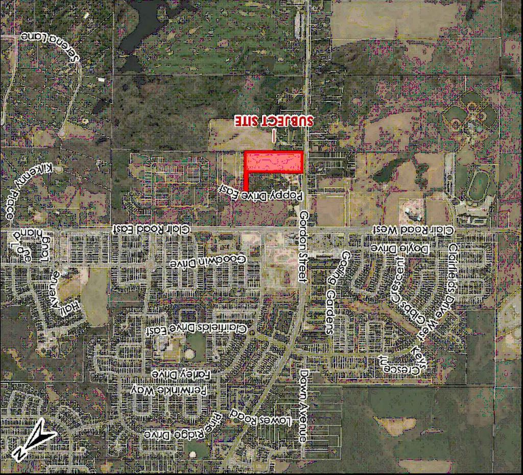
5 PLANNING JUSTIFICATION REPORT FOR 1888 GORDON STREET GUELPH, ONTARIO Site Description And Surrounding Land Uses 2.0 SITE DESCRIPTION AND SURROUNDING LAND USES 2.1 SUBJECT LANDS The subject site is located at 1888 Gordon Street at the east corner of Poppy Drive and Gordon Street in Guelph, Ontario, as shown on Figure 1. The site is approximately hectares, with one residential building, and the remaining site is vacant. To the immediate north is a garden nursery, and a large commercial/retail centre located north of Poppy Drive. Recent low density residential developments have been constructed along Poppy Drive and Hawkins Drive to the northeast, and Poppy Drive and Gordon Street to the southwest. To the south is a mix of general residential, natural areas and open space designated lands. Figure 1: Site Location 2.1
, Draft Schedule 2: Land Use")
6 Site Description And Surrounding Land Uses 2.2 EXISTING PLANNING CONTROLS Official Plan: Zoning by-law: The subject site is designated as High Density Residential in the City of Guelph Draft Official Plan (OPA 48), Draft Schedule 2: Land Use Plan (September 2012 consolidation) Figure 2. The existing City of Guelph Official Plan 2001 (September 2014 consolidation), currently in effect, designates the subject site as General Residential (Figure 3), and within the South Guelph Secondary Plan (Schedule 1A). The Zoning By-law identifies the site within the Township of Puslinch, County of Wellington, and as such, no zone category has been applied to the lands. Figure 2: OPA 42 Draft Schedule 2 2.2

7 Site Description And Surrounding Land Uses Figure 3: Official Plan 2001 Schedule 2.3
8 Development Overview 3.0 DEVELOPMENT OVERVIEW 3.1 OVERVIEW The Tricar Group is proposing six buildings, two, fourteen story residential buildings (buildings 1 & 2) to the northwest of the site with a linking single story amenity building, a ten story residential building to the northeast (building 3) and two four story residential buildings to the south east (buildings 4 & 5). The development will be subject to a future site plan approval application and an application to develop a Plan of Condominium. The Tricar Group is an experienced developer of high rise buildings and proposes to construct a compact high density residential development in the south end of Guelph. The proposed development aligns with the proposed secondary plan phasing and moves to meet growth and intensification targets for the City. The development will provide residential condominium living opportunities within close-proximity to the Gordon Street Corporate Business Park, retail and commercial blocks, and accessible public transportation with convenient routes to the University and downtown core. This development will create residential living space with open space to the adjacent natural areas, active and passive recreational amenities, together with a sense of place within the South Guelph planning area community. The development provides underground and surface parking. Three storeys of underground/enclosed parking are proposed for each of the five residential buildings, totaling 701 stalls. The underground and surface parking areas will have access off the internal main street connecting Gordon Street to the north access at the rear of the parcel. The proposed 14 storey (buildings 1 and 2) and 10 storey apartments (building 3) will consist of 156 units (building 1), 147 units (building 2) and 134 units (building 3). The four storey apartments (buildings 4 and 5) will consist of 40 units each. A mixture of one, two and three bedroom units will be available within the 14 storey apartments; one and two bedroom units will be available within the 10 storey apartment; and two bedroom units available within the four storey apartments. Each unit offers ample living space, amenities, views, and secure access. The units proposed in the apartments have a floor space ranging from 950 to 1600 square feet, which contribute to housing option variation to the residential market and to provides choice to consumers. The westerly 14 storey apartment building proposes seven (7) two storey townhouses oriented to Gordon Street, providing an enhanced façade and aesthetic street view from the public realm. Three single storey townhouses are proposed along the front of both 14 storey apartments, oriented towards the internal main street. Each of the four storey apartments propose four single storey townhouses fronting the internal main street and open space block interior to the site. The townhouses along Gordon Street and the private road are intended to be interactive with the 3.1
9 Development Overview apartment buildings by providing appropriate scale and massing to the street outside to create a vibrant pedestrian environment. The development proposes a large outdoor commons gathering place and an amenity building including a pool, both to be located within the centre of the site. The location provides uniform accessibility from the proposed residential buildings and informal surveillance to these areas for security. These large landscaped features are connected via sidewalks to all five residential buildings. A total of 41.7% of the site will be landscaped. This proposed development will provide for a variety of residential options within the South Guelph Planning Area. It is strategically located in proximity to public and active transit, employment opportunities, and commercial and retail amenities; providing a live-work-play compact development form. A conceptual site plan is attached as Appendix A. 3.2 PROPOSED APPLICATION The application submitted as part of this development is to: Apply for an Official Plan Amendment to the existing General Residential designation (Official Plan 2014 consolidation, in effect) to High Density Residential (Schedule 2, OPA 48, currently under appeal) with a density increase up to a maximum of 174 units per hectare. Apply for a R.4B residential zoning category on the subject property with specific provisions to permit townhouses, minor reductions of side yard setbacks and distance between buildings, and an increased Floor Space Index, density and height. 3.2
10 Land Use Policy Framework Overview 4.0 LAND USE POLICY FRAMEWORK OVERVIEW 4.1 PROVINCIAL POLICY STATEMENT, 2014 The Provincial Policy Statement (PPS) sets a policy foundation for regulating the development and use of land; it provides direction on matters of provincial interest and supports the enhancement of the quality of life for all citizens of Ontario. The legislation requires that Planning Act applications must be consistent with the Provincial Policy Statement. With regards to the Provincial Policy Statement, the proposal is consistent with following policies in support of the application: Building Strong Communities: The proposal supports the policies and guidelines of this section of the Provincial Policy Statement in the following ways: It s an efficient land use and will contribute to the mix of residential options; (1.1.1 a/b) The land use patterns pose no threat to the environment or public health and safety; (1.1.1 c) Avoids development and land use patterns that would prevent the efficient expansion of settlement areas in areas adjacent or close to settlement areas; (1.1.1d) Promoting cost-effective development patterns and standards to minimize land consumption and servicing costs; (1.1.1 e); and, Infrastructure is readily available (1.1.1 g). It also supports the Settlement Area objectives of: Settlement areas as the focus of growth; ( ) and Land use patterns within settlement areas shall be based on densities and mix of land uses, efficient use of land, resources and infrastructure; ( a) The development will provide a range and mix of housing types and densities to meet the projected current and future residents needs and supports the Housing objectives by: Directing development of new housing towards location where appropriate levels of infrastructure and public service facilities are available to support current and projected needs; (1.4.3c) and A healthy, active community will be promoted by planning streets and spaces to meet the needs of pedestrians which fosters social interactions and facilitates active transportation/community connectivity. (1.5) 4.1
11 Land Use Policy Framework Overview Infrastructure will be used in an efficient and cost-effective manner, and will be available to meet current and future needs. (1.6) It is our professional opinion, that the proposed Official Plan and Zoning By-law amendments are consistent with the PPS. 4.2 GROWTH PLAN FOR THE GREATER GOLDEN HORSEHOE, 2006 The Growth Plan was prepared under the Places to Grow Act, 2005 and implements Provincial Interest in building stronger, prosperous communities by managing growth of the Greater Golden Horseshoe to the planning horizon of An amendment to the population and employment forecasts updated the Plan to a planning horizon of 2041 to help communities to better plan for future growth and are in effect as of June 17, All applications initiated after June 16, 2006 must be in conformity with the Growth Plan. The City of Guelph is within the Outer Ring of the Greater Golden Horseshoe. Table 2 outlines the Distribution of Population and Employment to 2041 is as follows for the City: Table 2: Distribution of Population and Employment to 2041 for the City of Guelph Population 177, , ,000 Employment 94,000 97, ,000 The proposed development conforms to the policies for Designated Greenfield Areas (Section 2.2.7) and Managing Growth ( ) by: Contributing to the creation of complete communities; o Providing for a diverse range and mix of housing; o Integrating and contributing to sustaining the viability of transit services; o Supporting overall quality of life, including human health, for people of all ages and abilities through the planning for and provision of: a compact built form that reduces dependence on the automobile; public service facilities, co-located and integrated in community hubs, that are accessible by active transportation and transit; provides amenities, such as recreation facilities needed to support planned population; Contributing to the density target for residences and employment combined per hectare within the horizon of the plan; and Being on full municipal services and allowing the logical extension of these services. 4.2
12 Land Use Policy Framework Overview Therefore, in our professional planning opinion the proposed development is consistent with and conforms to Provincial policies in effect by efficiently utilizing land to provide for a mix of housing types/densities, directs growth to the Guelph Urban Area where municipal services are available, conforms to the secondary plan area proposed phasing, and completes an existing residential community. 4.3 LOCAL GROWTH MANAGEMENT STRATEGY The City of Guelph approved the Local Growth Management Strategy in The Strategy outlines and established targets for the City Growth which estimates approximately 175,000 people and 31,000 jobs by The Strategy further identifies policy focus on high density growth and intensification opportunities on vacant or under-used parcels of land. The minimum density targets to be achieved for the Guelph Urban area are 50 residents and jobs combined per hectare for new greenfield development (Growth Plan, 2006). The Gordon Road area development, abutting the Gordon/Clair intersection has developed within the past decade and is at a density of approximately 12 units per hectare, or 35 to 40 persons per hectare (LGMS, 2006; PPS, 2014). The proposed development located south of the existing community will contribute a density of approximately 155 units/ha (maximum of 175 units/ha); exceeding the LGMS goals. In addition to adhering to the Strategy s density goals, the development will support transit, walking and cycling for everyday activities (Section (h)). Although the development is located on the south edge of the City, it is within proximity to a large community mixed-use node and the transit, which make the site ideal for supporting a walkable community and reduce the number of vehicular trips. 4.4 CITY OF GUELPH OFFICIAL PLAN (SEPTEMBER 2014 CONSOLIDATION) The subject property is designated as General Residential in the current Official Plan, as shown on Figure 3. The Official Plan permits multiple unit residential buildings, such as townhouses and apartments, under the General Residential designation; however, density must not exceed 100 units per hectare (Section ). As such, the proposed development is seeking an amendment from General Residential to High Density Residential and an increase in density to a maximum of 175 units per hectare.. The proposed development generally conforms to the polices of the High Density Residential Land Use Designation: Multiple unit residential buildings in the form of four, ten and fourteen storey apartments are proposed on the subject site (7.2.41) 4.3
13 Land Use Policy Framework Overview This compact, high density development is supported by existing public transit, Gordon Street, which provides access to Highway 401 and the City of Guelph downtown core, and active transportation network provided via bicycle lanes and sidewalks ( b) Provides for a variety of housing types and forms within the South Guelph Planning Area ( c) The proposed development complies with the criteria established for multiple unit residential buildings are outlined in policies and : o Proposed development is in proximity to major employment (business park), commercial (Clair/Gordon Street mixed use node); and located on an arterial road (Gordon Street) (7.2.45) a) That the building form, massing, appearance and siting are compatible in design, character and orientation with buildings in the immediate vicinity; The 14 and 10 storey apartment buildings are sited along the northwest property line, with the two 14 storey buildings adjacent to an existing service commercial property. The 10 storey building is sited over 30 metres from the east property line, adjacent to vacant residential land. The two four storey residential buildings are staged along the southeast limit. The step-down approach from 14 to 10 to 4 storeys is considerate of the existing residences located south the subject site fronting Gordon Street, and will provides substantial privacy for both the existing and proposed residences. An Urban Design Brief has been prepared to address built form and interaction with the abutting properties and is summarized in Section 9.0 of this report b) That the proposal can be adequately served by local convenience and neighbourhood shopping facilities, schools, parks and recreation facilities and public transit; The development is located within proximity to public transit provided along Gordon Street, the mixed use node located at the intersection of Gordon Street and Claire Road, and Gosling Gardens Park and South End Community Park. These retail, commercial and recreational facilities are located within 1 km of the subject site. Public transit is available within 400 metres of the site c) That the vehicular traffic generated from the proposal can be accommodated with minimal impact on local residential streets and intersections and, in addition, vehicular circulation, access and parking facilities can be adequately provided; and Vehicle access is provided from Gordon Street, and circulation is provided through the site to the second ingress/egress point at the north corner of the property. Underground and surface parking will be provided. A Traffic Impact Study has been prepared and is summarized in Section 6.0 of this report. 4.4
14 Land Use Policy Framework Overview d) That adequate municipal infrastructure, services and amenity areas for the residents can be provided. Full municipal services are available to the site via Poppy Drive and Gordon Street. A servicing report has been completed and is summarized in Section 7.0 of this report. As discussed in Section 4.3 of this report, the minimum density targets to be achieved for the Guelph Urban area are 50 residents and jobs combined per hectare for new greenfield development (Growth Plan, 2006). The net density of development within the High Density Residential Land Use Designation shall not exceed 150 units per hectare (7.2.43). The proposed development is requesting allowance to contribute a density of approximately 155 units/ha, up to a maximum of 175 units/ ha.. The requested maximum density allows for variation of unit size within the proposed building footprint to accommodate market demands, including the potential to provide a variation of housing costs within the site, creating a mixed income development. The proposed development is located within a greenfield area, as identified on Schedule 1B of the City s Official Plan. Section outlines requirements for the planning and design of developments to contribute to the City s vision of a diverse and complete community. Development within greenfield areas must be compact, support linkages for active transportation (pedestrian, cycling), and promote live/work opportunities. The proposed development conforms to the greenfield area policies in Section , as outlined below: a) achieve an overall minimum density target that is not less than 50 residents and jobs combined per hectare in accordance with the Growth Plan policies. The density target will be measured in accordance with the provisions of subsection of the Growth Plan over the entire designated greenfield area to be developed; The proposed development will contribute a density of approximately 155 units/ha, up to maximum of 175 units/ha. b) ensure that new development is designed to promote energy conservation, alternative and/or renewable energy systems, and water conservation; A Community Energy Commitment Letter has been provided in Appendix B, addressing how the proposed development has been designed to promote energy conservation, water conservation and general sustainable environmental practices. c) create street configurations, densities, and an urban form that support walking, cycling, and the early integration and sustained viability of transit services; An existing bicycle lane on the east and west side of Gordon Street begins at the edge of the subject site, and extends north to the downtown core. Public transit is available via a bus stop 4.5
15 Land Use Policy Framework Overview located along Poppy Drive, approximately 400 metres from the subject site. A future sidewalk connection is proposed from the site to Gordon Street to provide safe accessibility for pedestrians to and from the mixed use node for shopping, entertainment, and amenity services. d) provide a diverse mix of land uses, including residential and employment uses, to support vibrant neighbourhoods; & f) promote, where appropriate through secondary planning the development of identifiable, pedestrian oriented neighbourhood scale urban villages through the use of medium and high density, street-related built form that contains a mix of commercial, residential and employment uses, as well as supporting live/work opportunities. These centres will be designed around active public spaces and street and pedestrian access that is well linked to the surrounding neighbourhood through walking, cycling and public transit; and The proposed residential development contributes to a complete community within the South Guelph area, as the adjacent land uses are comprised of natural heritage, commercial, retail, business district and other residential areas. The corporate business park and mixed use node make the proposed development an ideal location to support live/work opportunities for future residents. e) create high quality public open spaces with site design and urban design standards that support opportunities for transit, walking and cycling; An outdoor square and amenity building are proposed in a central location for the development. The siting of this indoor and outdoor amenity area provides equal accessibility to all residents of the community. Details of the proposed amenity spaces and additional urban design features are discussed in Section 9.0 of this report. f) develop and implement policies, including phasing policies and other strategies to achieve the intensification and density targets of this Plan. As discussed in point a) above, the proposed development will achieve the density targets and conforms to the phasing polices of this Plan. Section 3 of the Official Plan outlines general development policies which include Section 3.2 Community Form Statement. The proposed development conforms to the community form policies by proposing a vibrant residential community which will accommodate and increase the share of population growth. It meets the objectives of community form by assisting in guiding the location, scale, timing of development to ensure compact, orderly, and sustainable development and minimizing the cost of municipal services and infrastructure. It will help to achieve a moderate rate of population growth, the target of which is to increase by 1.5 percent of the total City population annually. Section 3.3 Urban Form policies outlines how the City will promote a compact urban form and gradual expansion of existing urban development. The proposed development will conform to these policies and assist with achieving the objectives by promoting mixed land uses in 4.6
16 Land Use Policy Framework Overview appropriate locations to provide residents opportunities to live, learn, work and shop in close proximity; develop in a suitable location adjacent to mixed uses linked by transportation networks and integrated through pedestrian access; and promote a range of building types to meet the diverse needs of the community. It will conform to the city s environmentally sustainable development urban form policies by using environmentally-friendly design concepts including, but not limited to glazing for bird friendly design, drought tolerant plants, high energy efficient units/lighting/appliances, locally sourced building materials, use of natural light, etc. Section 3.6 of the Official Plan outlines policies and objectives for Urban Design. The development conforms to the following objectives: Practice environmentally sustainable urban development by adhering to urban design principles that respect the natural features, reinforce natural processes and conserve natural resources; Conserve the City s built heritage (buildings, structures, landmarks, monuments, cultural landscapes, neighbourhoods) and to further assist conservation through complementary design of new buildings, landscapes and neighbourhoods; and Encourage compatibility and quality in the built environment while allowing for a diverse expression of site design by establishing design principles and guidelines to encourage excellence in design. It will promote physical planning that will reduce the need for and length of vehicular trips by providing for a variety of land uses, providing for alternative forms of transportation; and creating a compact development form. Improve the conditions for greater personal security within publicly accessible spaces, such as the public amenities provided on site and the parking facilities, by designing them with Crime Prevention Through Environmental Design (CPTED) principals. The site will be designed to promote accessibility to all, regardless of personal limitations. Promote the planting of street trees as desirable elements of the streetscape. Streetscape improvements will be undertaken as a component of the design and development of municipal public works or, as a condition of development approval, where appropriate. The proposed development conforms to the above mentioned Urban Design policies/objectives and others as set out within the Official Plan by providing sustainable and compatible urban development, natural heritage features, creating visual character and building material elements, and encouraging the use of transit. 4.7
17 Land Use Policy Framework Overview An Urban Design Brief has been submitted as part of the complete application. A summary of the report is provided in Section 9.0. Section 3.8 of the Official Plan outlines polices for Energy Conservation and Climate Change Protection. The objectives are: To promote a compact urban form and develop an energy efficient pattern and mix of land uses. To maximize opportunities for the use of energy efficient modes of travel and reduce energy consumption for motor vehicles within the City. To encourage energy efficient building design and construction techniques that minimizes space heating and cooling energy consumption. The proposed development is committed to energy conservation where possible and has outlined their commitment in the Community Energy Commitment letter enclosed as part of this Planning Act Application submission package. Section 7.2 of the Official Plan outlines policies and objectives for Residential designated lands. The development conforms to the following objectives: Contributes to accommodating the anticipated population growth; Contributes to locating various housing types necessary to accommodate a diversity of housing needs in a suitable location; Sited in an appropriate location to minimize potential conflict between residential and nonresidential uses; Sited in an area where municipal services and infrastructure are available; and Provides linkages between the proposed residential area and the existing employment, shopping, and recreational areas within the South Area planning community. The proposed development conforms to the above mentioned Residential objectives as set out within the Official Plan by providing sustainable and compatible urban development to accommodate growth, minimize land-use conflict, utilize existing servicing and infrastructure, and provide linkages for residents to nearby amenities and services. 4.8
18 Land Use Policy Framework Overview 4.5 OFFICIAL PLAN AMENDMENT NUMBER 48: ENVISION GUELPH OFFICIAL PLAN UPDATE The Official Plan update designates the subject property as High Density Residential. The overall goals and development density objectives for the Greenfield Area remain, in our opinion, similar to the adopted Official Plan. The remaining updates to the City of Guelph Official Plan were completed through OPA 48 and are intended to ensure that the Official Plan is in conformity with provincial legislation and City plans and studies. OPA 48 was approved by City Council in June 2012 but is not in effect. The strategic goals for the Official Plan (Section 2.2) which the proposed development helps to support include: Planning a complete and healthy community to preserve and enhance a safe, liveable and healthy community; ensure an appropriate range and mix of land use; and ensure development is appropriately phased and staged. Municipal Services direct development to those areas where full municipal services and related infrastructure are existing or can be made available while considering existing land uses. Urban Design building a compact, mixed-use and transit supportive community that are compatible with existing built form. The proposed development will conform to the new proposed Complete and Healthy Community policies which outline planning for complete community with a focus on achievement of a well-designed, vibrant city that provides access to employment opportunities, a range of housing options, local services and public transportation. The policies for Greenfield Area were renumbered but remain unchanged. Therefore, the proposed development still conforms to the policies as outlined in Section 4.4 of this report. Section 4.7 Community Energy was added to the plan, see Section 4.8 of this report and Community Energy Commitment Letter submitted as part of this application which outlines the proposed development commitment to energy. Urban Design policies have been updated, the proposed development conforms to the new policies by: Creating neighbourhoods with diverse opportunities for living, working, learning, and playing; Building compact neighbourhoods that use land, energy, water, and infrastructure efficiently and encourage walking; 4.9
19 Land Use Policy Framework Overview Engaging in place-making by developing a building, spaces and infrastructure that is permanent, enduring, memorable and beautiful, adaptable, flexible and valued; Improving conditions for greater personal security by incorporating Crime Prevention through Environment Design; Design for choices of mobility including walking, cycling, transit, and driving; and Reducing energy and water demand utilizing alternative energy systems. The four storey apartments (buildings 4 and 5) within the proposed development will conform to the policies for Built Form: Mid-Rise Buildings (Section 8.8) by ensuring the dwellings will create visual interest through material selection and architectural type, and be sited to provide appropriate human scale and allow for aesthetic views along Gordon Street. Underground parking is provided, and the minimal surface parking proposed will be adequately screened with landscaping. Pedestrian access is provided to the principal entrances from the public realm. The remaining three apartments (buildings 1, 2 and 3) proposed within the development will conform to the policies for High-rise buildings built form (Section 8.9) by ensuring tall buildings have a distinctive bottom, middle and top, include interesting architectural features and parking is provided primarily below grade. The new development will contribute to pedestrian-oriented streetscape by locating built form adjacent to, and addressing the street edge, placing principle entrances towards the street, and providing active uses that provide an interface with the public realm. Lighting will be provided at a sufficient level for building identification and safety but will be oriented/shielded to minimize glare or encroachment to adjacent properties. Landscaping will be provided for and will create visual interest, complement built form, and contribute to the public realm. 4.6 SOUTH GUELPH SECONDARY PLAN The South Guelph Secondary Plan (also known as Official Plan Amendment 2) provides planning policies specific to the southern areas that were annexed by the City from the Township of Puslinch in The primary goal of the Plan is to establish planning direction for the guidance of development. The subject property is designated General Residential on Schedule A of the Secondary Plan, which is envisioned to accommodate a range of housing types and densities to provide options for residents. Section of the Secondary Plan applies to lands designated General Residential within the South Guelph District Centre (SGDC). The SGDC includes lands surrounding the intersection of Clair Road and Gordon Street. The proposed development conforms to these policies as the residential units will be compatible with the adjacent existing and future uses within the SGDC; the site design will provide continuity between these uses; and the site layout has been designed to establish an attractive and definable gateway. The Conceptual Site Plan is 4.10
20 Land Use Policy Framework Overview provided in Appendix A, illustrating the proposed building layout and design. Urban design details have been summarized in Section 9.0 of this report. Section of the Secondary Plan outlines polices for Gordon Street gateway conditions. The development conforms to the gateway policies by committing to a detailed planting and landscape plan; built form controls, such as siting the buildings so they are located behind the belt of the plantings and landscaping along Gordon; and appropriate lighting and signage design. Such details will be provided at Site Plan. As per Section of the Secondary Plan, a servicing report and storm water management plan has been submitted as part of the complete application. Section outlines Phasing Policies for the South Guelph area. Prior to development in the Phase 2 area (a), east of Gordon Street and South of Clair Road, the trunk sewer along Clair Road, across Gordon Street must be extended to the east; and a connection to the existing trunk watermain located at the Gordon/Clair intersection must be provided. Details regarding proposed servicing are summarized in Section 7.0 of this report. The proposed development of this site will contribute varied housing options within the South Guelph planning area. The site is in proximity to live/work opportunities for future residents, include the commercial and retail stores within the multi-use node at Clair and Gordon Street; park amenities and transit stops. The development of the subject site provides opportunities for streetscape improvements and safe access to offsite amenities through the provision of new sidewalks along Gordon Street. The proposal has not yet been vetted through the site plan review committee; however, it is our opinion that there are opportunities for pedestrian linkages and improvements as a result of this development. It is our opinion that the development generally meets with the applicable polices of the South Guelph Secondary Plan. 4.7 THE COMMUNITY ENERGY INITIATIVE The Community Energy Plan was approved in 2007 which focuses on attracting quality investment, ensuring reliable and affordable energy, reducing environmental impacts, enhancing Guelph s competitiveness, and aligning public investment. The overall vision of the City of Guelph Community Energy Plan (CEP) is to create a healthy, reliable and sustainable energy future by continually increasing the effectiveness of how the residents and businesses of Guelph use and manage their energy and water resources. The proposed condominium building plans contribute to this overall vision for Guelph by utilizing energy efficiency initiatives during construction of the building, including a construction waste management plan, providing water and energy efficient material and appliances and HVAC systems. Energy efficient design features will be incorporated into the final unit designs. The proposed development is located adjacent to bike lanes provided along Gordon Street, and within 400 metres of bus stops and routes, providing alternative transportation options for future tenants. Situated just south of the multi-use node at Clair and Gordon Street, potential residents 4.11
21 Land Use Policy Framework Overview are located close to amenities, dining and entertainment within walking distance, and optimizes opportunities to take advantage of multiple transportation option. These factors will contribute to reducing vehicle journeys and contribute to the City s goal of reducing transportation energy by 25%. A compact development with high density residential will maximize utilization and provide housing choice to the residents wanting to live in the south end of Guelph. The development will integrate an active pedestrian connection between new and existing developments, and provide a focal point along the Gordon Street gateway for all modes of transportation entering/exiting the City. A substantial amount of landscaped open space is proposed, as well as an amenity building. The typical high density suburban requirements for landscape open space are 30 per cent. This development proposes 40 per cent. Stormwater management will be designed to capture and recharge the existing groundwater system. It is estimated that 80% of the runoff volume will be directed to groundwater. The development will reduce heat island effect by using light-colored building materials which have proven effective in reflecting more light. Minimal surface parking is proposed, reducing the area of asphalt parking by providing the majority or parking underground. The proposed development will encourage water efficiency by using ow-flow faucets, toilets, and showerheads throughout the units to reduce water consumption. The intent is for hot water domestic supply to come via condensing boiler systems. Heated storage tanks will be utilized to reduce fluctuations in the requirement for hot water under peak demand. Allowing for on-site storage reduces the amount of time required by residents to wait for hot water to come from centralized systems. Through the integration of high efficiency chiller/cooling tower systems and condensing boilers, the evaporation losses will be minimalized, even more than a conventional heating and cooling system. The vast majority of building materials to be used are available locally (800 km radius as defined in LEED standard), limiting environmental impact of source supply transportation. High recycled content material to be specified where possible and renewable finishes (such as flooring) will be offered as choices to purchasers of residential units. A construction waste diversion program will be in effect during the construction period. 4.8 CITY OF GUELPH URBAN DESIGN ACTION PLAN (2009) The Urban Design Action Plan was based on 10 principles and a range of opportunity areas. The 10 principals are as follows: 1. Create communities where there are diverse opportunities for living, working, learning and playing. 4.12
22 Land Use Policy Framework Overview 2. Build compact communities that use land, energy, water and infrastructure efficiently and encourage walking. 3. Showcase natural attributes as defining features of the city s character by making them highly visible and accessible. 4. Focus on place-making developing infrastructure, spaces and building that are permanent and enduring, memorable and beautiful, adaptable and flexible, and ultimately valued. 5. Conserve and celebrate the city s cultural and architectural heritage and reuse heritage assets. 6. Create a diversity of inviting accessible gathering places that promote civic engagement and a full range of social, cultural and economic interaction. 7. Provide and balance choices for mobility walking, driving, cycling and taking transit. 8. Establish a pattern of interconnected streets and pedestrian networks in which buildings frame and address public spaces. 9. Allow for a range of architectural styles and expressions that bring interest and diversity while responding appropriately to the scale and materiality of the local context. 10. Provide a setting for a variety of lifestyles and rich experiences. The proposal is located within the South Guelph Planning Area and in our opinion meets many of the objectives and principles of the plan by providing for: Variety of housing types and options along Gordon Street; located within close proximity to the business park and commercial/retail centre located at Clair and Gordon Street; Compact community which encourages walking; Servicing provided by existing infrastructure; Aesthetic and visually interesting streetscape and architectural design; Choices for mobility, including public transit stops located at Clair and Gordon, bicycle lanes available adjacent to the site along Gordon, and a proposed sidewalk connection from the site to Gordon Street; A range of architectural styles within the South Guelph planning area that brings interest and diversity while responding to scale and materiality of the local context; Significantly increasing the population of residents and workers with new housing units; and Minimize the presence of surface parking lots with underground parking garages. 4.13
23 Land Use Policy Framework Overview 4.9 ZONING BYLAW The Zoning By-law currently identifies the lands as within the Township of Puslinch, therefore no zone category has been applied to the subject site. The applicant is requesting an R.4B residential zoning category on the subject property with specific provisions to permit townhouses, minor reductions of the side yard setback and distance between buildings, and an increase of Floor Space Index, density and height. A detailed analysis of the R.4B zone compared to the proposed conceptual Site Plan is provided in Section
24 Development Proposal 5.0 DEVELOPMENT PROPOSAL 5.1 ZONING BY-LAW AMENDMENT: ZONING BY-LAW COMPARISON Provision R.4B High Density Apartment Site Provision Requested Permitted Uses Apartment Building; Nursing Stacked Townhouse; Cluster Yes Home; Home for the Aged; Retirement Residential Facility; Maisonette; Accessory Uses in accordance with Section 4.23; Home Occupation in accordance with Section 4.19 Townhouse; Apartment Building; Nursing Home; Home for the Aged; Retirement Residential Facility; Maisonette; Accessory Uses in accordance with Section 4.23; Home Occupation in accordance with Section 4.19 Minimum Lot Area 650m 2 31,923.6 m 2 No Minimum Lot 15 m 108.1m No Frontage Maximum Density 150 units/ha 175 units/ha Yes Minimum Front 6 metres and as set out in 6.0 m No Yard Section 4.24 Minimum Exterior 6 metres and as set out in N/A No Side Yard Section 4.24 Minimum Side Yard Equal to one-half the building height but not less than 3 metres and in accordance with section m (Bldg. 1 & 2 podium) 18.3 m (Bldg. 1 & 2) 6.05 m (Bldg. 4) Yes Minimum Rear Yard Maximum Building Height Minimum distance between buildings Equal to 20% of the Lot Depth, or one-half the Building Height whichever is greater, but in no case less than 7.5 metres. 10 storeys and in accordance with sections 4.16, 4.18, The distance between the face of one Building and the face of another Building either of which contains windows of Habitable Rooms, shall be one-half the total height of the two Buildings, and in no case less than 15 metres. The distance between the faces of any two Buildings with no windows to Habitable Rooms shall be a minimum of 15 metres m (Bldg. 3 podium) m (Bldg. 3) Apartments 4, 4, 10, 14, 14 storeys (47 m max) 20 m (10 storey and 4 storey building) (21 m required) 22 m (14 storey and 4 storey) (27 m required) No Yes Yes 5.1
25 Development Proposal Minimum Common Amenity Area Minimum Landscape Open Space (% of Lot Area) Buffer Strip Fences An amount not less than 30 m 2 per dwelling unit for each unit up to 20. For each additional dwelling unit, not less than 20 m2 of common amenity area shall be provided and aggregated into areas of not less than 50 m2. (Min. of 10,060m 2 required). 20% of the lot area for building heights from 1-4 storeys and 40% of the lot area for buildings from 5-10 storeys Where an R.4 zone abut any other residential zone, institutional, park, wetland or Urban reserve zone a buffer strip shall be developed In accordance with Section required (In accordance with Section 4.13) In accordance with Section 4.5 In accordance with Section ,091 m 2 (47.3%) No 41.7% No Buffer strip to be provided along rear property line (northeast) to the R.3 zone on the Reid s property. In accordance with Section 4.20 Off-Street Parking 701 (Garage and Underground) No 26 (Surface) = 727 total Accessory Building Amenity Building is in No or structures accordance with Section 4.5 Garbage, Refuse In accordance with Section 4.5 No Storage and Composters Floor Space Index Yes No No 5.2 PROPOSED SITE SPECIFIC REGULATIONS Building Height and Maximum Density The applicant is seeking special provisions to increase the maximum permitted height from 10 to 14 storeys, and to permit a density increase to accommodate a maximum of 175 units/ha. With the proposed height and density request, a commitment to incorporate community benefits into the development include, but are not limited to sustainable design features, and energy and water conservation measures (as indicated in the Community Initiative Letter, Appendix B). The Growth Plan for the Greater Golden Horseshoe and the growth targets set out in the City s Official Plan polices provide for intensification; specifically, within the downtown core and along corridors such as Gordon Street. In order to achieve the density targets established, a mix of building types, high rise developments have been approved in policy to meet with established targets. OPA 48 identifies the subject site as High Density Residential (Schedule 2, currently under appeal). The buildings have been designed to provide an appropriately scaled aesthetic street wall along Gordon Street and the main entrance/circulation to the development. 5.2
26 Development Proposal Permitted Uses The draft zoning by-law proposed for the subject site seeks special provisions to allow for the permitted uses of the R3 zone, in addition to all permitted uses under the R.4B zone. It is anticipated the phasing of development will occur over four to six years. During the development of the site, it is uncertain how housing market demands will change. Allowing for both apartments and townhouses on the subject site will provide an opportunity for flexibility to accommodate the current demand of housing needs in the City of Guelph Setbacks The draft zoning by-law proposed for the subject site seeks specific provisions to allow the following: Side yard setback of 4.8 metres; Distance between buildings of 20 metres; Floor Space Index of 2.8; Maximum height of 47 metres; and Maximum density of 175 units/ha. This intensification and compact development will require amended setbacks in order to achieve the direction set out in Official Plan polices from the City. The apartment buildings have been scaled with townhouses to ensure that the pedestrian environment is comfortable and appropriate. The request is in keeping with Provincial intensification targets, the City of Guelph Growth Management Strategy and the direction currently before Council regarding the Official Plan and Secondary Plan. 5.3 DRAFT ZONING BY-LAW Proposed Specialized R.4B Zone for 1888 Gordon Street: Permitted Uses In addition to the permitted uses listed in Section , the following shall also be permitted: Townhouses Regulation for Apartment and Townhouse Dwellings All regulations of the R4.B Zone as specified in Sections 4 and of the By-law with the following additions and exceptions shall apply to apartment and townhouse development on the subject site: 5.3
27 Development Proposal Minimum Side Yard Setback 4.8 metres Minimum Distance Between Buildings 20 metres Floor Space Index 2.8 Maximum Building Height 14 Storeys (47 m) Maximum Density 175 units/ha 5.4
28 Transportation 6.0 TRANSPORTATION Stantec prepared a Transportation Impact Study (TIS) for the proposed development, which has been provided as part of this application submission package. The TIS assesses the transportation impact of the proposed development, and was completed in accordance with the City of Guelph TIS Guidelines. Additional consideration was given to transit service and active transportation within the Study Area. The following methodology was used to analyze traffic operations and recommend transportation improvements: Future peak hour background traffic is estimated for future horizon years based upon a 1.5 per cent per annum growth rate as agreed upon with the City of Guelph during preconsultation. The background traffic forecasts also include additional traffic generated by the full build-out of nearby developments; Estimates of the expected net increase in future site traffic are generated for the proposed development using data from the Institute of Transportation Engineers (ITE) publication, Trip Generation, 9th Edition ; The future background traffic is combined with the net increase in subject site traffic to determine the total traffic volumes for future horizon years; The future peak hour intersection operations are analyzed for the future background and future total traffic conditions; and All the above data is used to determine the net impact on operational performance as a result of the subject site traffic, and to provide recommendations for road and/or traffic control improvements (if any) to address the identified impacts. The conclusions of the TIS are as follows: The existing base year (2016) weekday a.m. and p.m. peak hour traffic operations at the Study Area intersections are characterized by good levels of service and all movements operating within their theoretical capacities. Under future background conditions, most of the Study Area intersections are anticipated to operate within acceptable levels of service and volume to capacity ratios under the 2020, 2025, and 2030 horizons. The exception is the intersection of Gordon Street/Clair Road and the northbound left movement at Clair Road/Farley Drive. Several movements at the Gordon Street/Clair Road intersection are anticipated to approach capacity under the 2030 future background traffic condition. Right turn auxiliary lanes are warranted on the southbound and northbound approaches at the intersection of Gordon Street/Clair Road under 2020 future background traffic conditions and would alleviate noted deficiencies. However, proximity to buildings and utilities may not allow for additional lane construction. 6.1
29 Transportation The northbound left turn movement at Clair Road/Farley Drive operates at a LOS F and is approaching capacity under the 2030 future background horizon year. It is recommended to monitor the intersection of Clair Road/Farley Drive as traffic increases to identify whether the northbound left movement will require an advanced left turn phase to reduce delay and capacity deficiencies in future horizon years. Widening of Gordon Street between Clair Road and Maltby Road will be required prior to the 2020 horizon year to accommodate the future background growth and other area background developments. Volumes are noted to exceed the planning level road capacity (900 vphpl) of a single lane road under 2020 future background traffic conditions. Traffic signals are warranted for installation at the intersection of Gordon Street/Gosling Gardens-Gosling Gardens Site Access under 2020 future total traffic conditions with the subject proposed development fully developed. Under future total traffic conditions, all Study Area intersections with the exception of the Gordon Street/Clair Road intersection and the northbound left movement at Clair Road/Farley Drive operate within acceptable levels of service and volume to capacity ratios under 2020, 2025, and 2030 horizon. Similar operational deficiencies are observed and noted between the future total traffic and future background traffic conditions, although slightly exacerbated due to site generated traffic. Based on the estimated trips generated by the subject development, it is not anticipated that significant impacts to the local road network will occur. The recommendations of the TIS are as follows: Monitor the intersection of Clair Road/Farley Drive as traffic increases due to background growth in order to identify when the northbound left movement will require an advanced left turn phase to reduce delay and address capacity deficiencies in future horizon years. Monitoring should be completed to accommodate background traffic, and should be conducted regardless of the subject development. Investigate the feasibility of providing auxiliary right turn lanes on all intersection approaches at Gordon Street/Clair Road to alleviate existing deficiencies and accommodate future background growth. Deficiencies are observed under all future background horizon years. Widen Gordon Street between Clair Road and Maltby Road by 2020 to accommodate traffic generated by background growth and other area developments. Install traffic signals at the intersection of Gordon Street/Gosling Gardens-Gosling Gardens Site Access by 2020 to accommodate the total traffic forecasts associated with the completion of the proposed development. 6.2
30 Servicing and Stormwater Management 7.0 SERVICING AND STORMWATER MANAGEMENT Stantec prepared the Functional Servicing and Stormwater Management Report for the proposed development, which has been provided as part of this application submission package. The general conclusions are: Sanitary service is provided by the municipal system located on Poppy Drive just east of the site access. A flow control pipe and structure may be needed within this access to restrict flow leaving this site to 20.2 L/s. Water service is provided primarily from the existing 400mm watermain on Gordon Street fronting this site with a secondary connection point to the 150mm watermain on Poppy Drive to create a looped system. Enhanced (Level 1) water quality control will be provided for the site by a combination of OGS units, and infiltration galleries. Adequate water quality volumes will be provided to meet the MOE water quality requirements associated with infiltration facilities. The proposed system will infiltrate up to the 100-year event to maintain predevelopment conditions. Based on the findings of the report, the following recommendations are provided: The proposed SWM measures provided in the report be constructed as designed; The erosion sediment control measures be implemented during construction; The Stormwater Monitoring and Maintenance Program be carried out during and following construction; The proposed development can be adequately serviced through the connection to the existing services; and Overall site grading will provide for major overland flow conveyance to the downstream municipal road allowance, provide adequate cover over municipal services and generally match existing roads and boundary grades. The servicing and grading have been designed to meet MOE and municipal standards. 7.1
31 Environmental Impact Statement 8.0 ENVIRONMENTAL IMPACT STATEMENT A pre-consultation meeting that included City of Guelph, Tricar and Stantec staff was held at Guelph City Hall to discuss the proposed zone change required to accommodate the proposed development at 1888 Gordon St. on October 22, It was determined that a scoped EIS would be required since the Subject Property is within 120m of the Hall s Pond Provincially Significant Wetland (PSW) Complex, and that the EIS should discuss potential species at risk in the Study Area, and summarize the results of a tree inventory and compensation plan, hydrogeological study and geotechnical report. Through consultation with the City of Guelph and the GRCA, AET Group Inc. (AET) submitted a revised Terms of Reference (TOR) for the EIS to the City of Guelph on October 1, 2015, in accordance with the City of Guelph EIS Guidelines (City of Guelph, 2014). The revised TOR was approved by the GRCA and supported by City of Guelph Environmental Advisory Committee (EAC) at the December 9, 2015 meeting. The EIS was prepared based on consideration of the following policies: Policy 2.1 of the Provincial Policy Statement (MMAH, 2005) with guidance provided through the Natural Heritage Reference Manual (MNR, 2010) and Significant Wildlife Habitat Technical Guide (MNR, 2000); City of Guelph Official Plan (2001, consolidated 2012) with consideration for Official Plan Amendment 42 (OPA 42, under appeal); and Grand River Conservation Authority Policies and Regulation (150/06). Field investigations were conducted between October 2015 and July 2016 to confirm existing conditions, inventory existing vegetation, identify potential habitat of bat maternity roosts, waterfowl nesting, breeding birds, turtle nesting, and perform additional wildlife observations and assessments within the Study Area. The Scoped EIS characterizes the natural features and functions, describe the development, identify potential impacts and recommend appropriate mitigation and enhancement measures to protect, restore, and enhance the features onsite. Based on the results of the background review, applicable policies and field investigations conducted by Stantec and AET in support of the EIS, it was concluded that the unevaluated wetland is not a PSW; there are no ANSIs, significant valleylands, fish habitat, significant wildlife habitat, species at risk, or species at risk habitat in the Study Area; the woodlands on the Subject Property do meet the criteria for significance; and based on the evaluation, the unevaluated wetland meets the GRCA criteria for removal. 8.1
32 Environmental Impact Statement To address potential impacts identified in the EIS, mitigation measures have been recommended to avoid or minimize the potential negative effects. Recommended measures include the implementation of construction controls (i.e. construction timing windows and stormwater management) and the incorporation of restoration and enhancement measures (as appropriate) to offset any residual impacts that may occur. These management and mitigation measures are discussed in detail in the EIS, which has been submitted under a separate cover as part of a complete application. 8.2
33 Urban Design Brief 9.0 URBAN DESIGN BRIEF An Urban Design Brief (UDB) has been submitted under a separate cover, as a requirement for a complete application based on the proposed development. The UDB is an analysis of the architectural and urban planning conditions currently in place in the City of Guelph; and demonstrates how the proposed development at 1858 & 1888 Gordon Street offers design solutions that are sensitive to the site s location, articulates both public and private realms, and conforms with City s land use vision and design policy. The design policies relevant to the proposed development are taken from the City of Guelph Official Plan (Section 3.6) (September 2014 Consolidation), urban design updates as amended by Official Plan Amendment No. 48, South Guelph Secondary Plan (Section ), and the City of Guelph Urban Design Action Plan (2009). The proposed development conforms to the above mentioned Urban Design policies by providing sustainable and compatible urban development to accommodate growth, minimize land-use conflict, utilize existing servicing and infrastructure, provide linkages for residents to nearby amenities and services, preserves natural heritage features, creates visual interest and adds character through the selection of building material elements, and encourages the use of public and active transit. 9.1
34 Conclusions 10.0 CONCLUSIONS In Summary, the proposal is consistent with the Provincial Policy Statement and the Growth Plan, and it has been designed to reflect the existing and draft documents for the area including the Urban Design Action Plan, the Secondary Plan, and the Official Plan Update. The site is well served by transit, infrastructure and the form is compatible with surrounding uses. The development is consistent with numerous policy directions and the growth management strategy for additional greenfield polices of the Official Plan. The proposal will provide a variety of housing options contributing to the City s and Province s goals for intensification and efficient uses of land development and in our opinion represents good planning. It is our opinion that this development meets the general intent of the Official Plan policies. The proposal will provide housing opportunities and sustainable housing options for the community. It will act as a gateway to the downtown, provide enhanced pedestrian movement and will be a catalyst for other residential developments in the South Guelph Planning Area. 10.1
35 Appendix A Conceptual Site Plan CONCEPTUAL SITE PLAN A.1

36 N

37 Appendix B Energy Commitment Letter ENERGY COMMITMENT LETTER B.1
Planning Justification Report for 150 Wellington Street Guelph, Ontario
 Planning Justification Report for 150 Wellington Street Guelph, Ontario Prepared for: The City of Guelph on behalf of The Tricar Group 3800 Colonel Talbot Road London ON N6P 1H5 Prepared by: Stantec Consulting
URBAN DESIGN BRIEF URBAN DESIGN BRIEF 721 FRANKLIN BLVD, CAMBRIDGE August 2018
 URBAN DESIGN BRIEF URBAN DESIGN BRIEF 721 FRANKLIN BLVD, CAMBRIDGE August 2018 DESIGN BRIEF CONTENTS PART A 1.0 INTRODUCTION 2.0 DESCRIPTION & ANALYSIS OF SITE CONTEXT 3.0 DESIGN CONSTRAINTS AND OPPORTUNITIES
178 Carruthers Properties Inc.
 178 Carruthers Properties Inc. Planning Rationale for 178 Carruthers Avenue Site Plan Control Application June 2014 Table of Contents 1.0 Introduction 2.0 Overview of Subject Property 3.0 Current Zoning
URBAN DESIGN BRIEF Gordon Street City of Guelph. Prepared on behalf of Ontario Inc. March 25, Project No. 1507
 URBAN DESIGN BRIEF 1131 Gordon Street City of Guelph Prepared on behalf of 1876698 Ontario Inc. March 25, 2016 Project No. 1507 423 Woolwich Street, Suite 201, Guelph, Ontario, N1H 3X3 Phone (519) 836-7526
Complete Neighbourhood Guidelines Review Tool
 Complete Neighbourhood Guidelines Review Tool Prepared By: City of Regina Planning Department October 2014 Page 1 of 14 Community Development Review Checklist for Secondary Plans and Concept Plans The
Urban Design Manual PLANNING AROUND RAPID TRANSIT STATIONS (PARTS) Introduction. Station Study Areas
 Introduction. Station Study Areas") 111111 PLANNING AROUND RAPID TRANSIT STATIONS (PARTS) Introduction The ION rapid transit system will link Waterloo, Kitchener and Cambridge through a central transit corridor (CTC). There are a number
111111 PLANNING AROUND RAPID TRANSIT STATIONS (PARTS) Introduction The ION rapid transit system will link Waterloo, Kitchener and Cambridge through a central transit corridor (CTC). There are a number
PLANNING JUSTIFICATION REPORT
 PLANNING JUSTIFICATION REPORT 55 DELHI STREET CITY OF GUELPH PREPARED FOR: VESTERRA PROPERTY MANAGEMENT PREPARED BY: LABRECHE PATTERSON & ASSOCIATES INC. SCOTT PATTERSON, BA, CPT, MCIP, RPP PRINCIPAL,
CONTENTS 8.0 LAND USE 8.1 GENERAL LAND USE 8.2 RESIDENTIAL 8.3 MIXED USE 8.4 COMMERCIAL 8.5 EMPLOYMENT LANDS
 8-2 Land Use 8.0 LAND USE CONTENTS 8.1 GENERAL LAND USE 8.1.1 Uses provided for in all Land Use Designations 8.1.2 Uses prohibited in Hazardous Lands, Hazardous Sites and Special Policy Areas 8.1.3 Uses
Welcome. Walk Around. Talk to Us. Write Down Your Comments
 Welcome This is an information meeting introducing the applications for proposed redevelopment of the Yorkdale Shopping Centre site at 3401 Dufferin Street and 1 Yorkdale Road over the next 20+ years,
K. SMART ASSOCIATES LIMITED
 Planning Justification Report Zoning By-Law Amendment 185 King Street North Waterloo, Ontario April 7th, 2017 Project Reference Number 16-245 K. SMART ASSOCIATES LIMITED CONSULTING ENGINEERS AND PLANNERS
Figure 1- Site Plan Concept
 Figure 1- Site Plan Concept Parking will be provided underground on three levels at rate of 1.0 space/ unit; this rate includes all visitors parking. MMM Group has prepared a parking assessment (April,
DRAFT Northeast Quadrant of Kipling Avenue and Highway 7 DRAFT AUGUST 29, Goals Land Use. The goals of this Plan are to:
 AUGUST 29, 2017 12.15 Northeast Quadrant of Kipling Avenue and Highway 7 12.15.1 Goals 12.15.2 Land Use The goals of this Plan are to: 12.15.2.1 General Provisions: a) Ensure the development of a compact
New-Cast Mixed-use Development Proposal King Street West, Newcastle, Ontario
 URBAN DESIGN BRIEF New-Cast Mixed-use Development Proposal King Street West, Newcastle, Ontario TABLE OF CONTENTS: 1.0 Executive Summary 2.0 Creating Vibrant and Sustainable Urban Places: Excerpts from
Urban Design Brief. Watson Parkway North & Watson Road North Guelph, Ontario. Prepared by Coletara Development
 Urban Design Brief Watson Parkway North & Watson Road North Guelph, Ontario Prepared by Coletara Development December, 2013 Urban Design Brief, Coletara Development 1 Introduction This Urban Design Brief
URBAN DESIGN BRIEF 305, 309, & 315 SOUTHDALE ROAD WEST LONDON ONTARIO
 URBAN DESIGN BRIEF 305, 309, & 315 SOUTHDALE ROAD WEST LONDON ONTARIO CARVEST PROPERTIES LTD. December 2013 Section 1 - Land Use Planning Context 1.1 Subject Lands The subject lands are located immediately
URBAN DESIGN BRIEF. 2136&2148 Trafalgar Road. Town of Oakville
 URBAN DESIGN BRIEF 2136&2148 Trafalgar Road Town of Oakville Prepared By: METROPOLITAN CONSULTING INC For 2500674 Ontario Inc November 2016 TABLE OF CONTENTS Page No. 1.0 Introduction/Description of Subject
1.0 Purpose of a Secondary Plan for the Masonville Transit Village
 Report to Planning and Environment Committee To: Chair and Members Planning & Environment Committee From: John M. Fleming Managing Director, Planning and City Planner Subject: Masonville Transit Village
FORMER CANADIAN FORCES BASE (CFB) ROCKCLIFFE SECONDARY PLAN. Official Plan Amendment XX to the Official Plan for the City of Ottawa
 ROCKCLIFFE SECONDARY PLAN. Official Plan Amendment XX to the Official Plan for the City of Ottawa") FORMER CANADIAN FORCES BASE (CFB) ROCKCLIFFE SECONDARY PLAN Official Plan Amendment XX to the Official Plan for the City of Ottawa 1 INDEX THE STATEMENT OF COMPONENTS PART A THE PREAMBLE PAGE Purpose...
FORMER CANADIAN FORCES BASE (CFB) ROCKCLIFFE SECONDARY PLAN Official Plan Amendment XX to the Official Plan for the City of Ottawa 1 INDEX THE STATEMENT OF COMPONENTS PART A THE PREAMBLE PAGE Purpose...
PORT WHITBY COMMUNITY
 PORT WHITBY COMMUNITY SECONDARY PLAN UPDATE COMMUNITY IMPROVEMENT PLAN URBAN DESIGN GUIDELINES September 2015 DRAFT PROPOSED AMENDMENT NUMBER # to the Whitby Official Plan PURPOSE: The intent of this Amendment
URBAN DESIGN BRIEF 181 Burloak Drive, Oakville
 URBAN DESIGN BRIEF 181 Burloak Drive, Oakville February 2017 Our File: 1730B 230-7050 WESTON ROAD / WOODBRIDGE / ONTARIO / L4L 8G7 / T: 905 761 5588/ F: 905 761 5589/WWW.MHBCPLAN.COM TABLE OF CONTENTS
YONGE STEELES CORRIDOR SECONDARY PLAN. Young + Wright / IBI Group Architects Dillon Consulting Ltd. GHK International (Canada) Ltd.
 Ltd.") PART A: PREAMBLE 1.0 PURPOSE The purpose of this Secondary Plan is to provide a development framework for intensification of the Yonge/ Steeles corridor including the north side of Steeles Avenue West
PART A: PREAMBLE 1.0 PURPOSE The purpose of this Secondary Plan is to provide a development framework for intensification of the Yonge/ Steeles corridor including the north side of Steeles Avenue West
6 Growth Management Challenges and Opportunities
 6 Growth Management Challenges and Opportunities The Town has established a goal of attaining a 50% participation rate with respect to employment opportunities versus residential population. The Town s
Regency Developments. Urban Design Brief. Holyrood DC2 Rezoning
 Regency Developments Urban Design Brief Holyrood DC2 Rezoning Stantec Consulting Ltd. 7-31-2017 1. Overview Regency Developments intends to rezone the lands located at 8510 and 8511 93 Avenue, within the
Mark-up of the effect of the proposed Bronte Village Growth Area OPA No.18 on the text of section 24, Bronte Village, of the Livable Oakville Plan
 Mark-up of the effect of the proposed Bronte Village Growth Area OPA No.18 on the text of section 24, Bronte Village, of the Livable Oakville Plan Notes: This document is provided for information purposes
*** DRAFT 2 FOR PUBLIC REVIEW ***
 6.7 The area is generally bounded by the Red Hill Valley Parkway to the west, Lake Avenue to the east, the Queen Elizabeth Way (QEW) to the north, and by the properties just south of Queenston Road to
Westwind Developments Ltd. PIONEER LANDS AREA STRUCTURE PLAN - PROPOSED AMENDMENT
 FEBRUARY 2013 TABLE OF CONTENTS 1.0 BACKGROUND... 1 1.1 Amendment... 1 2.0 LOCATION & CONTEXT... 2 2.1 Land Ownership... 2 3.0 POLICY CONTEXT... 3 3.1 Municipal Development Plan... 3 3.2 Capital Region
13 THORNHILL YONGE STREET STUDY IMPLEMENTATION CITY OF VAUGHAN OPA 669 AND TOWN OF MARKHAM OPA 154
 13 THORNHILL YONGE STREET STUDY IMPLEMENTATION CITY OF VAUGHAN OPA 669 AND TOWN OF MARKHAM OPA 154 The Planning and Economic Development Committee recommends the adoption of the recommendations contained
Planning Justification Report for 644 & 646 Huron Street London ON Zoning By-law Amendment Prepared for: Jose Pinhal 665 Kipps Lane London ON N6P 1H
 Planning Justification Report for 644 & 646 Huron Street London ON Zoning By-law Amendment Prepared for: Jose Pinhal 665 Kipps Lane London ON N6P 1H Prepared by: Luis Claro 67 Edgevalley Rd London ON N5Y
Official Plan Review: Draft Built Form Policies
 PG.30.1 REPORT FOR ACTION Official Plan Review: Draft Built Form Policies Date: May 15, 2018 To: Planning and Growth Management Committee From: Chief Planner and Executive Director, City Planning Division
Urban Design Brief December 23, 2015 Southside Construction Group Official Plan & Zoning By-Law Amendment
 Urban Design Brief Proposed Official Plan & Zoning By-Law Amendment 3244, 3263 and 3274 Wonderland Road South Southside Group December 23, 2015 TABLE OF CONTENTS Page No. INTRODUCTION... 1 SECTION 1 LAND
Urban Design Brief to 1557 Gordon Street & 34 Lowes Road West
 Urban Design Brief 1533 to 1557 Gordon Street & 34 Lowes Road West Reid s Heritage Homes Ltd. & 883928 Ontario Ltd. and RHH Property Management Ltd. City of Guelph Zoning By-law Amendment November 2017
Trafalgar Road Corridor Planning Study Open House
 Trafalgar Road Corridor Planning Study Open House June 24, 2013 6:30-8:30 p.m. Oakville & Trafalgar Rooms Overview The Livable Oakville Plan identifies the lands along Trafalgar Road, between the QEW and
Official Plan Review
 Official Plan Review Summary Report - The Built Environment August 2014 Part 1: Introduction Planning for a healthy, prosperous and sustainable community is an important goal for our municipality. From
THE CITY OF VAUGHAN BY-LAW BY-LAW NUMBER A By-law to adopt Amendment Number 1 to the Official Plan of the Vaughan Planning Area.
 THE CITY OF VAUGHAN BY-LAW BY-LAW NUMBER 015-2014 A By-law to adopt Amendment Number 1 to the Official Plan of the Vaughan Planning Area. NOW THEREFORE the Council of the Corporation of the City of Vaughan
[PLANNING RATIONALE] For Site Plan Control and Lifting of Holding Zone By-Law 101 Champagne Avenue. May 23, 2014
![[PLANNING RATIONALE] For Site Plan Control and Lifting of Holding Zone By-Law 101 Champagne Avenue. May 23, 2014](/thumbs/75/71599615.jpg "[PLANNING RATIONALE] For Site Plan Control and Lifting of Holding Zone By-Law 101 Champagne Avenue. May 23, 2014") [PLANNING RATIONALE] For Site Plan Control and Lifting of Holding Zone By-Law 101 Champagne Avenue May 23, 2014 Contents 1.0 Introduction... 2 2.0 Site Context... 2 2.1 Adjacent Uses... 2 Figure 1: Site
[PLANNING RATIONALE] For Site Plan Control and Lifting of Holding Zone By-Law 101 Champagne Avenue May 23, 2014 Contents 1.0 Introduction... 2 2.0 Site Context... 2 2.1 Adjacent Uses... 2 Figure 1: Site
Report Regarding Site Plan Control for 55 Wellspring Way (File No. SP-06-16)
") Report Regarding Site Plan Control for 55 Wellspring Way (File No. SP-06-16) Executive Summary: The purpose of this report is to provide Council with information regarding site plan control under Section
Report Regarding Site Plan Control for 55 Wellspring Way (File No. SP-06-16) Executive Summary: The purpose of this report is to provide Council with information regarding site plan control under Section
141 GEORGE STREET PLANNING RATIONALE
 141 GEORGE STREET PLANNING RATIONALE MINOR ZONING BY-LAW AMENDMENT NOVEMBER 2, 2016 PLANNING RATIONALE 223 McLeod Street Ottawa, ON K2P 0Z8 613.730.5709 fotenn.com INTRODUCTION FOTENN Consultants is acting
Planning Justification Report
 Planning Justification Report Application for Zoning By-law Amendment Prepared for: Sherrill Becker (OK Tire Auto Service) Prepared By: Black, Shoemaker, Robinson & Donaldson Limited June 2015 Sherrill
DOWNTOWN GEORGETOWN PLANNING STUDY
 DOWNTOWN GEORGETOWN PLANNING STUDY Community Workshop #3 Thursday, May 4, 08 The Planning Partnership OVERVIEW OF STUDY, PROCESS & MILESTONES We are here PURPOSE OF THE STUDY To develop a clear vision
KANATA CENTRUM 255 KANATA AVENUE OFFICIAL PLAN AMENDMENT ZONING BY-LAW AMENDMENT
 KANATA CENTRUM 255 KANATA AVENUE OFFICIAL PLAN AMENDMENT ZONING BY-LAW AMENDMENT JUNE 2015 PREPARED BY: FOTENN Consultants Inc. 223 Mcleod Street Ottawa, ON K2P OZ8 (613) 730-5709 PREPARED FOR: Kanata
Bloor St. W. Rezoning - Preliminary Report
 STAFF REPORT ACTION REQUIRED 1638-1644 Bloor St. W. Rezoning - Preliminary Report Date: April 1, 2008 To: From: Wards: Reference Number: Toronto and East York Community Council Acting Director, Community
ELMVALE ACRES SHOPPING CENTRE MASTER PLAN
 ELMVALE ACRES SHOPPING CENTRE MASTER PLAN Contents 1.0 INTRODUCTION... 2 2.0 LOCATION... 2 3.0 EXISTING CONTEXT... 2 4.0 VISION & GUIDING PRINCIPLES... 2 5.0 LAND USE AND BUILT FORM... 4 5.1 St. Laurent
Sustainable Growth. Sustainable Growth
 2 Sustainable Growth Sustainable Growth SUSTAINABLE GROWTH 2.1 COMMUNITY VISION... 2-5 2.2 THE CITY SYSTEM... 2-7 2.2.1 AREAS... 2-7 2.2.2 CITY-WIDE SYSTEMS... 2-8 2.2.3 PROVINCIAL PLAN BOUNDARIES AND
Clairtrell Area Context Plan
 Clairtrell Area Context Plan March 2005 Urban Development Services City Planning Contents 1. Introduction... 4 2. Development Structure... 6 2.1 Streets... 7 2.1.1 Sheppard Avenue and Bayview Avenue...
2136 & 2148 Trafalgar Road Town of Oakville Region of Halton
 PLANNING JUSTIFICATION REPORT 2136 & 2148 Trafalgar Road Town of Oakville Region of Halton Zoning By-Law Amendment Application 2500674 Ontario Inc. November 2016 Table of Contents Page 1.0 Location/Summary
URBAN DESIGN BRIEF New Street Burlington, ON
 3225-3237 New Street Burlington, ON MARCH 2017 Prepared for: Royal Living Development Group Inc. Prepared by: adesso design inc. 218 Locke Street South, 2nd Floor Hamilton, ON L8P 4B4 t. 905.526.8876 3225-3237
The Corporation of the TOWN OF MILTON
 Report to: From: Chair & Members of the Administration & Planning Standing Committee W.F. Mann, Director of Planning and Development Date: April 16, 2012 PD 022-12 (Z19/11) Subject: Technical Report Proposed
The West Vaughan Employment Area Secondary Plan Policies
 Part 2: The West Vaughan Employment Area Secondary Plan Policies 2.1 General Policies It is the policy of Council: 2.1.1. That the West Vaughan Employment Area (the WVEA), identified on Schedule 1, will
Queen Street West - Zoning Amendment Application - Preliminary Report
 STAFF REPORT ACTION REQUIRED 944-952 Queen Street West - Zoning Amendment Application - Preliminary Report Date: February 6, 2013 To: From: Wards: Reference Number: Toronto and East York Community Council
10 COPE DRIVE. May 08, 2018 Planning Rationale and Design Brief. Site Plan Control
 10 COPE DRIVE May 08, 2018 Planning Rationale and Design Brief Site Plan Control Prepared for: Taggart Realty Management 225 Metcalfe Street, Suite 708 Ottawa, ON K2P 1P9 taggart.ca Prepared by: Fotenn
Tel: (705) Fax: (705)
 Fax: (705)") 521 and 525 Essa Road City of Barrie Tel: (705) 812-3281 Fax: (705) 812-3438 Email: INFO@IPSCONSULTINGINC.com 1 5 0 D U N L O P S T R E E T E A S T, S U I T E 2 0 1, B A R R I E O N T A R I O L 4 M 1 B
521 and 525 Essa Road City of Barrie Tel: (705) 812-3281 Fax: (705) 812-3438 Email: INFO@IPSCONSULTINGINC.com 1 5 0 D U N L O P S T R E E T E A S T, S U I T E 2 0 1, B A R R I E O N T A R I O L 4 M 1 B
Draft Urban Hamilton Official Plan. Amendment No. XX
 1 of 75 The following text, together with: Draft Appendix A Appendix B Volume 1, Schedule E-1 Urban Land Use Designations Appendix C Volume 1, Appendix A Parks Classification Map Appendix D Volume 1, Appendix
EXISTING COMPREHENSIVE PLAN
 EXISTING COMPREHENSIVE PLAN Town Center Land Use Element: V. LAND USE POLICIES Town Center Mercer Island's business district vision as described in "Your Mercer Island Citizen-Designed Downtown" was an
and Richmond Street West - Official Plan Amendment Application - Preliminary Report
 STAFF REPORT ACTION REQUIRED 822-838 and 860-862 Richmond Street West - Official Plan Amendment Application - Preliminary Report Date: August 14, 2017 To: From: Wards: Reference Number: Toronto and East
ONTARIO MUNICIPAL BOARD
 PL 120483 ONTARIO MUNICIPAL BOARD Applicant/Appellant: 2124123 Ontario Limited Subject: OPA, Rezoning and Draft Plan of Subdivision Municipal Address: 3940 Highway 7 East Municipality: City of Markham
Planning Justification Report
 Planning Justification Report 98 Farley Drive Reid s Heritage Homes Ltd. City of Guelph Zoning By-law Amendment December 2017 Planning Justification Report 98 Farley Drive City of Guelph Zoning By-law
TABLE OF CONTENTS 1.0 INTRODUCTION... 3
 TABLE OF CONTENTS 1.0 INTRODUCTION... 3 1.1. BACKGROUND... 3 1.2. THE PROPOSAL... 5 2.0 EXISTING POLICY FRAMEWORK... 5 2.1. PROVINCIAL POLICY STATEMENT (PPS)... 5 2.2. CITY OF LONDON OFFICIAL PLAN (OP)...
SCHEDULE 'A' TO BY-LAW as Amended by AMENDMENT NO. 90 TO THE WHITBY OFFICIAL PLAN
 SCHEDULE 'A' TO BY-LAW 6413-10 as Amended by 6553-11 AMENDMENT NO. 90 TO THE WHITBY OFFICIAL PLAN SECTION A: GROWTH PLAN CONFORMITY PURPOSE: LOCATION: BASIS: The purpose of this Amendment is to: conform
East Bayshore Road Neighbourhood
 East Bayshore Road Neighbourhood Northridge Property Management Urban Design Brief 3195 East Bayshore Road City of Owen Sound January 2016 East Bayshore Road Neighbourhood Northridge Property Management
Commercial Development Proposal Tenth Line Road. Planning Rationale Report. Minto Developments Inc.
 Commercial Development Proposal 2168 Tenth Line Road Report September 2015 Prepared for Minto Developments Inc. Paquette Planning Associates Ltd. 56 Hutchison Avenue Ottawa, Ontario K1Y 4A3 PH: 613-722-7217
2. Shaping Waterloo Region s Urban Communities
 2. Much of the region s growth over the past several decades has occurred in suburban areas that separated where people live from where they work and shop. This pattern of growth has increased the need
7437, 7439 and 7441 Kingston Road - Zoning By-law Amendment and Site Plan Control Applications - Preliminary Report
 STAFF REPORT ACTION REQUIRED 7437, 7439 and 7441 Kingston Road - Zoning By-law Amendment and Site Plan Control Applications - Preliminary Report Date: August 13, 2015 To: From: Wards: Reference Number:
and services The protection and conservation of environmentally significant and sensitive natural heritage features and functions.
 6. Land Use 6.0 Preamble A healthy and livable city is one in which people can enjoy a vibrant economy and a sustainable healthy environment in safe, caring and diverse neighbourhoods. In order to ensure
646 Kingston Road - Official Plan Amendment and Zoning Amendment Applications - Preliminary Report
 STAFF REPORT ACTION REQUIRED 646 Kingston Road - Official Plan Amendment and Zoning Amendment Applications - Preliminary Report Date: December 8, 2014 To: From: Wards: Reference Number: Toronto and East
QUEEN-RIVER SECONDARY PLAN
 34 QUEEN-RIVER SECONDARY PLAN 34. QUEEN RIVER SECONDARY PLAN 1. INTRODUCTION The Queen-River area is approximately 6.4 hectares and is located at the eastern edge of the Downtown as shown on Map 34-1.
burlington mobility hubs study Downtown Burlington Mobility Hub
 burlington mobility hubs study Downtown Burlington Mobility Hub Draft Precinct Plan Workbook PIC #3, September 7, 2017 downtown mobility hub objectives City staff and their consultants are proposing an
DAVENPORT VILLAGE SECONDARY PLAN
 27 DAVENPORT VILLAGE SECONDARY PLAN 27. DAVENPORT VILLAGE SECONDARY PLAN 1. VISION FOR THE DAVENPORT VILLAGE SECONDARY PLAN Davenport Village, municipally known as 830, 940, 980 and 1100 Lansdowne Avenue,
280 Manse Road - Official Plan Amendment, Zoning Amendment, Draft Plan of Subdivision Applications - Preliminary Report
 STAFF REPORT ACTION REQUIRED 280 Manse Road - Official Plan Amendment, Zoning Amendment, Draft Plan of Subdivision Applications - Preliminary Report Date: March 11, 2014 To: From: Wards: Reference Number:
The Corporation of the Town of Milton
 Report To: From: Council Barbara Koopmans, Commissioner, Planning and Development Date: May 7, 2018 Report No: Subject: Making it Possible Positioning the Town s Strategy for Growth and Economic Development
Land Use Amendment in Southwood (Ward 11) at and Elbow Drive SW, LOC
 at and Elbow Drive SW, LOC") 2018 November 15 Page 1 of 10 EXECUTIVE SUMMARY This land use amendment application was submitted by Rick Balbi Architect on 2017 August 31 on behalf of Sable Developments Ltd, and with authorization from
2018 November 15 Page 1 of 10 EXECUTIVE SUMMARY This land use amendment application was submitted by Rick Balbi Architect on 2017 August 31 on behalf of Sable Developments Ltd, and with authorization from
1071 King Street West Zoning Amendment Application - Preliminary Report
 STAFF REPORT ACTION REQUIRED 1071 King Street West Zoning Amendment Application - Preliminary Report Date: August 9, 2012 To: From: Wards: Reference Number: Toronto and East York Community Council Director,
Planning Rationale Fernbank Road, Ottawa. Major Zoning By-law Amendment and Site Plan Control Application Ontario Inc.
 Planning Rationale Major Zoning By-law Amendment and Site Plan Control Application 5264 Fernbank Road, Ottawa 1872089 Ontario Inc. March 2014 Planning Rationale Major Zoning By-law Amendment and Site Plan
Urban Design Brief Fanshawe Park Road. Competition Toyota
 Urban Design Brief 1300 Fanshawe Park Road Competition Toyota May 2, 2014 TABLE OF CONTENTS Page No. INTRODUCTION... 1 SECTION 1 LAND USE PLANNING CONTEXT... 1 1.1 The Subject Lands... 1 1.2 The Proposal...
St. Lawrence Neighbourhood Focused Area - Official Plan Amendment Status Report
 STAFF REPORT ACTION REQUIRED St. Lawrence Neighbourhood Focused Area - Official Plan Amendment Status Report Date: May 21, 2015 To: From: Wards: Reference Number: Toronto and East York Community Council
150 Eighth Street Zoning By-law Amendment Application Preliminary Report
 REPORT FOR ACTION 150 Eighth Street Zoning By-law Amendment Application Preliminary Report Date: March 27, 2019 To: Etobicoke York Community Council From: Director, Community Planning, Etobicoke York District
4780 Eglinton Avenue West - Zoning By-law Amendment and Draft Plan of Subdivision Applications - Preliminary Report
 STAFF REPORT ACTION REQUIRED 4780 Eglinton Avenue West - Zoning By-law Amendment and Draft Plan of Subdivision Applications - Preliminary Report Date: May 29, 2014 To: From: Wards: Reference Number: Etobicoke
CONTENTS 2.0 A FRAMEWORK FOR SUSTAINABLE GROWTH 2.1 MANAGING SUSTAINABLE GROWTH THE VISION TO GOALS AND OBJECTIVES 2.3 MARKHAM STRUCTURE
 2 A Framework for Sustainable Growth 2.0 A FRAMEWORK FOR SUSTAINABLE GROWTH CONTENTS 2.1 MANAGING SUSTAINABLE GROWTH THE VISION TO 2031 2.2 GOALS AND OBJECTIVES 2.2.1 Protecting the Natural Environment
Planning Justification Report for 505 Talbot Street London ON
 Planning Justification Report for 505 Talbot Street London ON Zoning By-law Amendment Prepared for: 505 Talbot Limited 3800 Colonel Talbot Road London ON N6P 1H5 Prepared by: Stantec Consulting Ltd. 600-171
Urban Design Brief Proposed Residential Development 5219 Upper Middle Road City of Burlington
 Urban Design Brief Proposed Residential Development 5219 Upper Middle Road City of Burlington Prepared by Weston Consulting Prepared for BLOOMFIELD DEVELOPMENT INC. Date: March 2017 Table of Contents 1.
20 & 30 Frank Nighbor Place
 Engineering Land / Site Development Municipal Infrastructure Environmental / Water Resources Traffic / Transportation Structural Recreational Planning Land / Site Development Planning Application Management
ARLINGTON COUNTY, VIRGINIA
 ARLINGTON COUNTY, VIRGINIA County Board Agenda Item Meeting October 15, 2005 DATE: September 28, 2005 SUBJECT: Request to Advertise the adoption of the 2005 Clarendon Sector Plan C. M. RECOMMENDATION:
6. REGIONAL AND COMMUNITY FACILITIES DESIGNATIONS 6.1. OBJECTIVES FOR REGIONAL AND COMMUNITY FACILITIES LAND USE DESIGNATIONS
 6. REGIONAL AND COMMUNITY FACILITIES DESIGNATIONS INTRODUCTION The Regional and land use designations provide the primary locations for uses which satisfy the health, education and other service needs
Policies and Code Intent Sections Related to Town Center
 Policies and Code Intent Sections Related to Town Center The Town Center Vision is scattered throughout the Comprehensive Plan, development code and the 1994 Town Center Plan. What follows are sections
SUBJECT: Proposed Downtown Mobility Hub Precinct Plan and Proposed Official Plan Policies
 Page 1 of Report PB-81-17 SUBJECT: Proposed Downtown Mobility Hub Precinct Plan and Proposed Official Plan Policies TO: FROM: Committee of the Whole Planning and Building Department Report Number: PB-81-17
599 Kennedy Road - Official Plan Amendment and Zoning Amendment Application - Preliminary Report
 STAFF REPORT ACTION REQUIRED 599 Kennedy Road - Official Plan Amendment and Zoning Amendment Application - Preliminary Report Date: March 7, 2017 To: From: Wards: Reference Number: Scarborough Community
ADMINISTRATION RECOMMENDATION(S) 2018 January 25. That Calgary Planning Commission recommend APPROVAL of the proposed Land Use Amendment.
 2018 January 25. That Calgary Planning Commission recommend APPROVAL of the proposed Land Use Amendment.") Page 1 of 9 EXECUTIVE SUMMARY This land use amendment proposes to redesignate a parcel from DC Direct Control District to Multi-Residential Contextual Grade-Oriented (M-CG) District to allow for multi-residential
Page 1 of 9 EXECUTIVE SUMMARY This land use amendment proposes to redesignate a parcel from DC Direct Control District to Multi-Residential Contextual Grade-Oriented (M-CG) District to allow for multi-residential
PUBLIC OPEN HOUSE HURONTARIO-MAIN CORRIDOR SECONDARY PLAN
 PUBLIC OPEN HOUSE HURONTARIO-MAIN CORRIDOR SECONDARY PLAN Tuesday, February 28, 2012 6pm 9pm 1 st Floor Atrium, City Hall 2 Wellington Street West, Brampton 1 POLICY FRAMEWORK The 2006 Provincial Growth
John M. Fleming Managing Director, Planning and City Planner. Old East Village Dundas Street Corridor Secondary Plan Draft Terms of Reference
 Report to Planning and Environment Committee To: From: Subject: Chair and Members Planning & Environment Committee John M. Fleming Managing Director, Planning and City Planner Old East Village Dundas Street
McCowan Precinct Plan Study Background & Deliverables
 1 DRAFT & WITHOUT PREJUDICE McCowan Precinct Plan Study Background & Deliverables In September, 2011, City Planning (Scarborough District) began a study of an area within the Scarborough Centre, identified
Welcome to the Oakridge Centre Open House
 Welcome to the Oakridge Centre Open House Why is the City hosting this event? This open house is to inform you of a rezoning application submitted to the City of Vancouver to amend the existing CD-1 (Comprehensive
30 and 44 Zorra Street - Zoning By-law Amendment Application - Preliminary Report
 STAFF REPORT ACTION REQUIRED 30 and 44 Zorra Street - Zoning By-law Amendment Application - Preliminary Report Date: March 14, 2016 To: From: Wards: Reference Number: Etobicoke York Community Council Director,
Clair-Maltby Community visioning
 Clair-Maltby Community visioning workshop #1 Summary April 27th, 2017 Table of Contents INTRODUCTIon 1 PURPOSE 1 CONSULTATION STRUCTURE 2 PARTICIPANT FEEDBACK 3 VISIONING EXERCISE 8 ONLINE SURVEY RESULTS
ROAD CLOSURE AND LAND USE AMENDMENT SILVER SPRINGS (WARD 1) NORTHEAST OF NOSEHILL DRIVE NW AND SILVER SPRINGS ROAD NW BYLAWS 2C2018 AND 29D2018
 NORTHEAST OF NOSEHILL DRIVE NW AND SILVER SPRINGS ROAD NW BYLAWS 2C2018 AND 29D2018") Page 1 of 19 EXECUTIVE SUMMARY This application proposes redesignating two parcels in the community of Silver Springs from Special Purpose Future Urban Development (S-FUD) District and undesignated road
Page 1 of 19 EXECUTIVE SUMMARY This application proposes redesignating two parcels in the community of Silver Springs from Special Purpose Future Urban Development (S-FUD) District and undesignated road
LAND USE AMENDMENT CORNERSTONE (WARD 3) 60 STREET NE AND COUNTRY HILLS BOULEVARD NE MAP 26NE BYLAW 22D2017
 60 STREET NE AND COUNTRY HILLS BOULEVARD NE MAP 26NE BYLAW 22D2017") Page 1 of 14 EXECUTIVE SUMMARY This Land Use Amendment application covers an area of 43.76 hectares ± (108.14 acres ±) located in northeast Calgary, bound by Country Hills Boulevard NE to the south and
Page 1 of 14 EXECUTIVE SUMMARY This Land Use Amendment application covers an area of 43.76 hectares ± (108.14 acres ±) located in northeast Calgary, bound by Country Hills Boulevard NE to the south and
Bel-Air Lexus Automobile Service Station
 Bel-Air Lexus Automobile Service Station Design Brief 443-447 McArthur Avenue Ottawa April 30, 2015 14-1299-MCA Site Details Application: Site Plan Control Legal Description and Municipal Addresses: 443
2.0 A FRAMEWORK FOR SUSTAINABLE GROWTH CONTENTS
 2-2 A Framework for Sustainable Growth 2.0 A FRAMEWORK FOR SUSTAINABLE GROWTH CONTENTS 2.1 MANAGING SUSTAINABLE GROWTH THE VISION TO 2031 2.2 GOALS AND OBJECTIVES 2.2.1 Protecting the Natural Environment
WITNESS STATEMENT Of. Ronald Blake. On behalf of the Intervenor The Corporation of the City of Markham
 Filed: 2013-06028 EB-2012-0451 Exhibit L.EGD.COM.2 Page 1 of 7 WITNESS STATEMENT Of Ronald Blake On behalf of the Intervenor The Corporation of the City of Markham In the matter of an application by Enbridge
Commercial, Retail and Tourism Executive Summary December 2018
 Town of Wasaga Beach Official Plan Review, Retail and Executive Summary December 2018 1 An Official Plan directs where and how to grow The preparation of a new Official Plan for Wasaga Beach is an opportunity
MOUNT PLEASANT SECONDARY PLAN & VILLAGE BLOCK PLAN. Wednesday, March 5, 2008 Informal Public Open House
 MOUNT PLEASANT SECONDARY PLAN & VILLAGE BLOCK PLAN Wednesday, March 5, 2008 Informal Public Open House 1. Welcome & Introductions 2. Highlights of Provincial Growth Plan 3. Overview and Status Update -
URBAN DESIGN BRIEF. Terms of Reference. Purpose. When is an Urban Design Brief Required
 Purpose An Urban Design Brief (UDB) is intended to describe and illustrate proposed designs for new development projects and demonstrate how the City s Urban Design Guidelines and other City policies have