Landscape and Visual Effects Report
|
|
|
- Hannah Nancy Bridges
- 6 years ago
- Views:
Transcription

1 Plan Change 50 Queenstown Town Centre Zone Landscape and Visual Effects Report Marion Read Principal Read Landscapes 8 th October 2014
2 1.0 Introduction 1.1 Queenstown Lakes District Council is proposing a plan change for an area of land adjacent to the existing Town Centre Zone and the base of Bowen Peak. The plan change area encompasses the Lakeview Holiday Park bounded by Glasgow Street, Thompson Street, Man Street and Hay Street; the additional blocks bounded by Man Street, Isle Street, Hay Street and Camp Street; and the block bounded by Beach Street, Hay Street, Lake Street and Man Street. 1.2 This report has been requested as an adjunct to the proposal. It is intended to provide a landscape and visual assessment to complement and supplement the Populous Fearonhay Urban Design Framework and the peer review of that work undertaken by Clinton Bird Urban Design Limited. In undertaking this assessment I have been guided by the principles and process of the Guidelines for Landscape and Visual Impact Assessment 1. This manual, while not yet adopted by the New Zealand Institute of Landscape Architects, has been promoted by the Institute as a guide to best practice through a series of master classes. 1.3 I have based my assessment on the photo montages prepared by Populous Fearonhay and included in the urban design reports and on the observations made on a specific site visit in September In I addition I have applied my extensive knowledge of the site and the wider Queenstown area. 1.4 In addition to the reports mentioned above I have examined the following documents: the Assessment of Environmental Effects; the Queenstown Height Study: Landscape and Urban Design Assessment; the proposed plan provisions. 1.5 For completeness, I have considered objectives and policies relevant to landscape issues from Section 4 District Wide of the Queenstown Lakes District Plan (the District Plan). 2.0 Landscape assessment 2.1 Landscape baseline An assessment of landscape effects should deal with the effects of change and development on the landscape as a resource. It should entail the assessment of how a proposal will affect the character of the landscape and its makeup including aesthetic and perceptual elements. 1 Landscape Institute and Institute of Environmental Management and Assessment. (2013) Guidelines for Landscape and Visual Impact Assessment. Routledge: London.
3 The scope of the landscape that needs to be covered should incorporate the full extent of the landscape around the development area which may be affected by the proposed development. In my opinion this includes Ben Lomond and Bowen Peak (to the skyline); the township extending approximately from Robbins Road - Camp St -Beach Street to One Mile Creek; and Queenstown Bay As the area incorporates a portion of the town the following aspects of the townscape need to be considered also: its relationship to the wider landscape including topography; the grain of the built form and it relationship to historic patterns; layout, scale and density of built form and their architectural qualities; patterns of landuse; green spaces, their types and significant vegetation The plan change area is located on a lake terrace elevated above the current lake level, and dropping in elevation to the north east. The terrace drops steeply to the current lake level and is backed by cliffs and a steep slope which extents up to form the lower slopes of Bowen Peak and the backdrop to Queenstown township in views from the east. The western portion of the plan change area is located on a spur which extends from the mountainside and penetrates the lake terrace Built development extends over the terrace down to the Lake edge. The lake margins and the terrace escarpment are the location of larger buildings, mainly commercial developments although some single family homes remain. The existing development on the more northern terrace surface is relatively small scale with buildings, mainly older family homes, open space and trees interspersed within a traditional grid pattern of streets, and this provides a fine grain to this part of the landscape The Lakeview camping ground occupies a significant portion of the historic lake terrace surface. It comprises large areas of open space (for camping and for campervans); a fringe of tiny cottages; and a scattering of large conifers and other mature trees which dominate, particularly the lakeward fringes, of the area. A number of these trees are protected by the District Plan Overall the townscape in the plan change area includes a variety of architectural forms and colours. It exhibits an irregular spatial distribution of buildings, trees and open spaces. Many of the existing buildings are older homes. It has a largely domestic character at present. 2 Paraphrased from the Guidelines for Landscape and Visual Impact Assessment, P74.
4 2.1.7 Ben Lomond, Bowen Peak and Queenstown Hill together provide a mountainous context to Queenstown township. While all of these mountains are clad, in the main, by wilding exotic conifer forest, most viewers would see this as providing a natural context to the township. Queenstown Bay, while modified in the vicinity of Steamer Wharf and being the location of other jetties and moorings, provides a further natural context to the township Consequently I would summarise the significant features of the landscape in the vicinity of the proposed plan change area as currently being a fine-grained urban form maintained within the historical grid pattern and located over contemporary and historic beach terraces and with an essentially domestic character. The township forms the mid-ground between the natural landscapes of the lake and the mountains. Both of these natural landscape areas include but are not dominated by structures: jetties and similar structures around parts of the lake margin, and the Skyline and gondola on the mountainside. They retain, overall, a predominantly natural character I consider that the landscape character of the proposed plan change area and its context is vulnerable to change from the modification of the shoreline; the cluttering of the lake surface with structures; the alteration of the urban form; and the proliferation of roads, tracks and structures on the mountain slopes It is to be noted that the entirety of the plan change area is currently zoned for high density residential development. If this development were to take place then it would significantly diminish the fine grain of the urban areas of the landscape, increasing the scale of built form and replacing the domestic character with a more commercial one. The block bounded by Isle Street, Man Street, Hay Street, and Brecon Street, for example, has an average site coverage of approximately 26.4% (calculated from Council s public GIS site). Most of the buildings within this block are single story older homes, although some are used as offices and other types of businesses. This contrasts with the allowable site coverage of 65% (with a maximum foot print of 500m 2 ) and a maximum height of 8m currently allowed by the existing High Density Residential zoning. Consequently the current planning regime already anticipates the alteration of the fine grain urban form. This is demonstrated in the Populous Fearonhay photo montage attached to this report as Appendix 1 which illustrates the potential bulk which could result from this plan change and the height of development already allowed by the current rules of the District Plan.
5 2.2 Assessment of landscape effects The proposed plan change will allow for a building coverage of 80% in the Lakeview subzone and 70% in the Isle Street subzone. Comparing this with a current allowable site coverage of 65% means that there is a proposed, but not a great, increase in the permissible site coverage. This increase in site coverage will allow for considerably larger buildings than are currently to be found within the plan change area, but not very much larger in terms of footprint, than those allowed for under the current rules. Similarly, it will reduce the amount of green space within the Isle Street subzone which is now formed by many private gardens, but not beyond that which the District Plan already anticipates. Reserve areas are proposed within the Lake View subzone, and those on the south eastern side of the area will assist in balancing the increase in built form within that area to a degree. These reserves encompass the area containing most of the protected trees within the plan change site The proposed plan change will allow for increases in the maximum height for buildings to 12m, with varying heights proposed in the Lakeview subzone of between 4.5m and 26m. At 12m the proposal complies with the Queenstown Height Study recommendation that the increase in building height within the area now proposed for the plan change be limited to one story higher than those most proximate and I agree with this position. This will ensure that built form within the plan change area will not dominate or overshadow (both literally and figuratively) the neighbouring areas. It will also help to ensure that the underlying topography remains expressed through the built form. The Height Study also noted that what is now described as the Lakeview subzone had the capacity to absorb further height up to seven stories but that this should be located to the rear of that site, and I also agree with this position. The proposed plan change reflects this locating the highest potential buildings to the north of the terrace adjacent to an area of cliffs where they will have a natural backdrop which will dwarf even seven storied buildings The increase in the size and scale of buildings and the subsequent loss of open space will result in the loss of a sense of a domestic scale to the built form of the vicinity. These changes will result in a coarsening of the grain of the township, in particular within the Isle Street subzone. This will result in an alteration to the existing character of the township. It is the case, however, that development within this area which fully exploited the existing development potential of the existing zoning would create a similar effect In addition to the generalised increases in height and site coverage, specific provisions have been made to allow for a height limit of 15.5m on a site greater than 2000m 2 with frontages onto both Man and Isle Streets. The allowance of this greater height within the Isle Street
6 subzone does not comply with the recommendations of the Height Study that increases be limited to one story higher than those most proximate. The Height Study did, however, note that there would be some advantages in being able to see a landmark building or buildings from the Shotover Street / Brecon Street intersection to draw people up the Brecon Street Steps and I also agree with this. To this end I consider that a greater height limit in this vicinity to that proposed generally would be appropriate to achieve such a landmark building and that it would ideally be located on one of the corners of Brecon and Man Streets. I do not consider that allowing this increased height in this limited area would make any significant difference to the alteration of character that would already occur The subsequent increase in the coarseness of the grain of the built form in the plan change area will increase the contrast between the township and its natural context in terms of both the lake and its margins and the Ben Lomond Scenic Reserve. While this could be interpreted as a loss of small town charm, by the same token, the increase in contrast could heighten the appreciation of and value of the natural context of the township It is noted that the proposed plan change will not alter the character of the lake or lakeside areas, or that of the face of Ben Lomond and Bowen Peak. Consequently it is the case that the overall change in landscape character brought about through the proposed plan change within the wider landscape area will be small. 2.3 Visual baseline The visual baseline should identify the areas from which the development would be visible, the groups of people who may experience views of the development and the viewpoints where they will be affected and the nature of the views from these points Populous Fearonhay have identified a range of representative viewpoints from the Gorge, Queenstown Hill, Kelvin Heights, and the Botanic Gardens peninsula. (I note that the locations marked on the perspectives key are only approximate). These are all public locations from which both residents and visitors are likely to view the site. I consider this to be an appropriate and adequate array of locations from which to assess generalised visual effects. I also consider, however, that consideration of views from within the cemetery, as an important community feature, should be included. I understand that photo montages of views from the Cemetery are being prepared but I have not had the advantage of seeing them prior to undertaking this assessment.
7 2.4 Visual assessment public locations Perspective 1 shows the view from a section of Gorge Road, to the north of the Plan Change area. From this perspective the majority of the Plan Change Area will be seen over existing development and the Queenstown Recreation Ground. The predominant features of the view are the flank of Bowen Peak and Cecil and Walter Peaks more distantly. Intervening trees outside of the plan change area obscure the Isle Street subzone from view. The Lake View subzone is located behind the larger trees in the distance. Most of these trees are not protected. The intervening land is zoned High Density Residential It is probable that most of the large trees shown screening development in the Lake View subzone from view in this montage will be removed to facilitate development. This would make the proposed Plan Change area and development within it more readily visible than suggested. It would, none the less, form a small, even insignificant, portion of this view which will remain focused on Cecil and Walter Peaks and the flank of Bowen Peak. I do not consider that the alterations to this view which would result from the proposed plan change would adversely affect the visual amenity of this view Perspective 2 show a view of the site taken from Queenstown Hill. From this location the primary components of the view are the lake, Ben Lomond and Bowen Peak, with Cecil and Walter Peaks forming the backdrop. This view exhibits the classic features of the picturesque 3, the dominant landscape aesthetic in this country, and some of the features of landscape shown to be components of the most favoured views by Swaffield and Fairweather 4. From the presence of these features I make the presumption that this view is likely to be highly valued As noted above, development in the plan change area will coarsen the fabric of that part of the township, altering the character from small scale, residential to comparatively large scale commercial. This will have the visual effect of changing the rather haphazard, colourful appearance of much of the area into a more structured one, with less intervening green space. This will diminish the contribution of this area to the picturesque quality of this view. The extent of this effect on the overarching quality of the broader picturesque landscape view will, however, be small, and I consider that the high visual amenity of this view will be maintained. 3 For a discussion of the features of this aesthetic and its role in landscape planning in New Zealand see Read, M. (2009). Planning and the Picturesque: A Case Study of the Dunedin District Plan and its Application to the Management of the Landscape of the Otago Peninsula, in: Olwig, K R and Mitchell, D (eds). Justice, Power and the Political Landscape (Routledge:Oxford). 4 Fairweather, J. R., & Swaffield, S. R. (2001). Visitor experiences of Kaikoura, New Zealand: an interpretive study using photographs of landscapes and Q method. Tourism Management, 22,
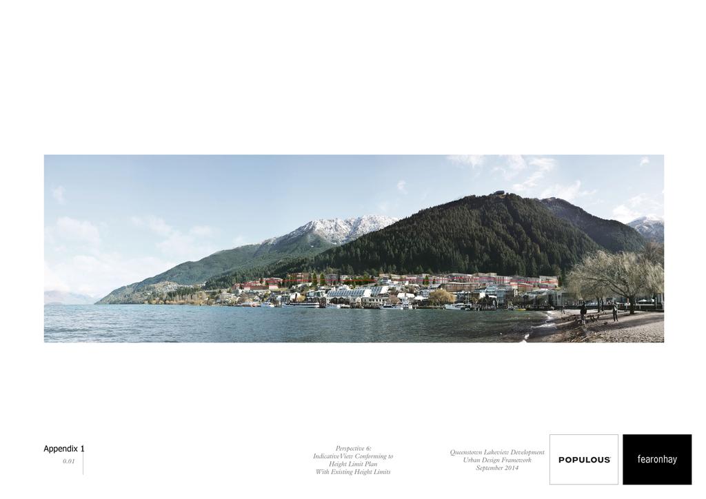
8 2.4.5 Perspective 3 shows a view from Kelvin Heights. While development in the plan change area, particularly within the Lake View subzone, would be visible from some locations along the Peninsula, it would also be obscured from view from many. These available views are distant and such development will not have any effect on the overall quality of views to Bowen Peak and Ben Lomond. It should be noted that from this location little of the Isle Street subzone will be visible, and that the group of protected trees, oaks and conifers, will be between the viewer and all but the most westerly development in the Lake View subzone, assisting it to blend into the background. I consider that the proposed plan change would have no perceptible effect on the visual amenity of these views Perspective 6 shows the view to the subject site from the eastern end of the Queenstown foreshore. A rendered version of this perspective has been provided and is appended to this report as Appendix 2. I note that neither perspective shows the actual protected trees within the plan change area, although the rendered perspective includes an approximation of them and additional trees which may be currently present but have no protection. Perspectives 7 and 8 are taken from points on the Botanic Gardens Peninsula and as they are similar, both in content and effect I will examine them together It is from these perspectives that the greatest alteration to the view and view quality will occur. The current view has a number of significant components. The first is the lake and its margin. On the north western side of the bay this incorporates jetties and boats and the Steamer Warf building. To their west St Omer Park provides a more natural edge to the lake. Behind the lake margin is located a scattering of larger buildings located on the current lake terrace and the escarpment behind including the shops in Shotover and Beach Streets, the Crown Plaza, Outrigger, Peppers, Rydges and St Moritz Hotels. Between and behind these buildings are located many smaller buildings, often older single family homes, many being used as business premises, and some of the cabins located in the Lake View camping ground. These smaller buildings are interspersed with small trees which soften their appearance and contribute to the fine grain of this part of the existing view. This fine grained development, where it is located on the lake terrace, provides a sense of depth between the edge of the escarpment and the mountains behind. This contributes to the picturesque qualities of these views. The other major component of these views is Ben Lomond, Bowen Peak and the Skyline which form the back drop Much of the fine grain of the intermediate area in these views will be diminished by development which could occur in accordance with the existing High Density Residential zoning. This means that while this area currently has a quaint, colourful, small town appearance that is likely to change. Development occurring to the limits proposed in the Plan
9 Change will diminish this fine grain and quaint appearance of the urban component of these views further. It will not, however, significantly reduce the picturesque quality of the overall views. The lake and its foreshore will not alter. Neither will Ben Lomond or Bowen Peak, save that a very small sliver of the latter will no longer be visible in these views. There will be some loss of the sense of depth currently gained in these views and with it some loss of the relationship between the built form and the topography, but this relationship will remain legible across the face of the mountain On a more specific level, the views across the lake of the Brunswick Street / Thompson Street intersection as it is currently configured focuses on a large opening which allows views directly into the plan change area at ground level, along Thompson Street. A significant proportion of this area, the more exposed part at the top of Brunswick Street in particular, is to be a reserve and thus the visual quality of this part of the view will be preserved. To the west of this, however, buildings could be constructed so as to potentially allow for the full facades to be exposed to viewing from this direction. The proposed plan change provisions allow for buildings to be built right up to the margin of Thompson Street but require that they comply with a recession plane of 45 o from 4.5m above that margin. Buildings in this location will be a controlled activity with control reserved (among other things) over the contribution to the quality of streetscape and a requirement that they provide visual interest, avoid blank walls visible from public locations, and do not allow parking to dominate the streetscape. In addition, as the predominant view is to the lake this is also likely to mean that windows, terraces, outdoor seating and similar will also face onto Thompson Street. I consider that this should be adequate to ensure that buildings along Thompson Street not be constructed so as to present their rear to the street and have an adverse effect on these views The Cemetery at the top of Brecon Street is an important public space. Currently views from the cemetery, while partially obscured by trees within the Lakeview camping ground and the James Clouston Reserve, are possible to the lake, the Remarkables, Cecil Peak and Queenstown Hill. Views to the Remarkables could be partially obscured from parts of the Cemetery by development to 12m within the Isle Street subzone and views to Cecil Peak area could also be lost. These views from the cemetery, which connect it with the broader landscape, are, in my opinion, important There are no specific rules which relate to the Cemetery within the plan change proposals. Currently the Cemetery Road reserve runs along approximately 50% of the south western margin of the Cemetery. This offers some protection to the views out of the Cemetery which have been identified as vulnerable. Currently a carpark occupies the north western portion of Lot 1 DP 27703, the mini golf operation, which is adjacent to the south eastern margin of the

10 cemetery and which is identified as Area A in the illustration below. The openness of this area currently assists in enabling views out of the Cemetery. This site is currently zoned High Density Residential with a commercial overlay. This means that buildings up to 8m in height could be built in this area. Accepting that this does form the permitted baseline it would, nonetheless, be ideal if the area along this boundary which is currently car parking could be retained as open space so as to maintain views out of the cemetery. An ideal solution would be a land swap enabling the extension of the road reserve along this boundary of the Cemetery. Alternatively I consider maintaining the 8m height limit within Area A would assist in in maintaining views out of the Cemetery. Cemetery Area A of adjacent site Brecon Street Cemetery Road Fig 1: Aerial photograph of the Queenstown Cemetery with context overlain by the relevant planning map illustrating Area A. Aerial and planning map downloaded from Council s public GIS interface at on 2 nd October Visual assessment private locations Dwellings in Man Street between Thompson Street and Hay Street currently have a view to the north of the James Clouston Reserve backed by cottages within the camping ground. The flank of Bowen Peak itself is largely obscured from view by the large trees in the reserve and just to the north of its boundary. A total of four of these trees, cedars currently located within the area proposed to become the Lakeview subzone, are protected features in the terms of the District Plan and are intended to remain. The cottages provide the view with a quaint quality. It is proposed to allow for the construction of buildings up to 12m in height on the northern side of this reserve. These buildings are required, by the structure plan to present an active frontage to this reserve. This will alter the views from these dwellings in Man Street. While the intervening trees will soften the views of these buildings across the reserve, the presence of three storied buildings on the far side of the reserve will alter the character of these views from quaint and small town to urban. It is to be noted that these dwellings are located within the High Density Residential Zone and so the replacement of
11 these single family homes is likely. Most significantly these dwellings gain their primary view to the south east over the lake and that this will remain unchanged. Consequently I consider that while these views are adversely affected, the extent of this adverse effect is small Dwellings on the western side of Glasgow Street currently have views to the east and the south which encompass cottages to the east of the street (on the Lynch block ) and extend above and between them to the Kelvin Peninsula, Botanic Gardens Peninsula, the Remarkables and the lake. It is my opinion that these views are likely to be considered important by the residents of these dwellings. Development according to the High Density Residential zoning which currently applies would obscure some of the Remarkables and most, if not all, of the Botanic Gardens Peninsula and Kelvin Peninsula from view. Views to the lake would remain, at least down the street corridor. The proposed plan change imposes a minimum setback of 4.5m along the Glasgow Street frontage of the plan change area, and a maximum building height of 12m with a 25 0 recession plane from 2.5m above the Glasgow Street boundary. Despite the required set back and recession plane, it is still my opinion that structures built to the full capacity of the proposed zone in this location will further obscure views of the Remarkables from the existing dwellings in Glasgow Street. The degree of this effect is small, however, and views to the lake would remain unaffected. Consequently, while this is an adverse effect of the proposed plan change, the extent of this effect is small. I understand that photo montages of views from this area are being prepared but I have not had the advantage of seeing them prior to undertaking this assessment. 3.0 Proposed plan provisions 3.1 It is my understanding that Council wishes to achieve a series of swaps between existing reserve land and existing freehold land in order to reconfigure their distributions. The resultant pattern is to include a reserve on the corner of Thompson and Man Streets. This is the location of eight of nine protected trees within the Plan Change area. I consider that maintaining this as open space would contribute significantly to the visual amenity of future development on the site to its north west for two reasons. The first is that because the configuration of Brunswick and Thompson Streets is such that it affords views into the plan change area from across Queenstown Bay at street level. This could potentially provide views of the full height of future buildings. The reserve to be located above Brunswick Street will assist in protecting the amenity of views from the Botanic Gardens by ensuring that this will not occur. The second contribution to the visual amenity of the plan change area is through the maintenance of the protected trees, some of which are very large. These trees will assist in integrating the larger buildings to their north and north west into their context, provide
12 these buildings with a sense of scale and help to avoid the raw effect new developments can have when mature trees are absent. 3.2 It is proposed to impose a 4.5m height limit on buildings within this proposed reserve area at the corner of Thompson Street. I consider that limiting the height of any future building to 4.5m will help to protect the contribution this reserve will make to reducing the visual effects of development to its north. I also consider that it is necessary to restrict the amount of built form that may be located within this area so as to avoid damage to the protected trees and to ensure that the role of the reserve as green space is not compromised. 3.3 I note that the Zone Standards in S retain the existing height limit for the High Density Residential zone over the block bounded by Hay, Lake, Beach and Man Streets but currently identified in the proposed plan change documents by lot numbers. I understand that this will allow for slightly more dense development within this block. I do not anticipate that this will have any significant landscape or visual effects. 3.4 The proposed assessment matters relating to the landscaping undertaken with the development of a convention centre within the Lakeview subzone are as follows: 3) Planting and landscaping designed to: Maintain access to winter sun Integrate site landscape design with that of the Square Comply with CPTED principles I consider that these are appropriate but consider that they should be extended to apply to all development within the subzone. This would ensure that landscaping and planting when it occurs would be co-ordinated within the area. In addition I consider that they should be expanded to include the following: Utilise trees where practicable to assist the built form to blend into its mountain backdrop 4.0 Queenstown Lakes District Council Plan 4.1 There are a number of aspects of Section 4 District Wide Issues which relate to the effects of development on the broader landscape. It is to be noted that it is generally considered and noted in Appendix 8 of the District Plan, that the Ben Lomond scenic reserve is a part of the Outstanding Natural Landscape (Wakatipu Basin). It is also generally considered that the surface of the Lake and its margins, except within the Queenstown Town Centre Waterfront Zone, are part of the Outstanding Natural Landscape (District Wide). Consequently, there are general policy considerations in the District Plan which apply and these are located in S4.2
13 Landscape and S4.9 Urban Growth. I will address the relevant objectives and policies which relate to these landscapes in the order in which they are found within the District Plan Objective: Subdivision, use and development being undertaken in the District in a manner which avoids, remedies or mitigates adverse effects on landscape and visual amenity values. Policies: 1 Future Development (a) To avoid, remedy or mitigate the adverse effects of development and/or subdivision in those areas of the District where the landscape and visual amenity values are vulnerable to degradation. This proposed plan change would facilitate the alteration of the urban form but the degree of alteration over that which is already anticipated under the existing District Plan rules is not considered to be significant. It would not affect the shoreline, lake surface or mountain slopes. Overall, the degree of modification which will occur will not degrade the overall landscape quality or visual amenity of the broader landscape (b) To encourage development and/or subdivision to occur in those areas of the District with greater potential to absorb change without detraction from landscape and visual amenity values. The proposed plan change would not alter the urban boundary of Queenstown township. The proposed plan change will alter the character of the landscape to a degree but this is not considered to detract from the landscape to a significant degree. Adverse visual effects on the landscape are considered to be small and localised in effect and the proposed plan change will not detract from overall visual amenity to any significant degree. 4.4 (c) To ensure subdivision and/or development harmonises with local topography and ecological systems and other nature conservation values as far as possible. The proposed plan change structure plan would locate the tallest buildings in the areas most able to absorb future development. The extension of a continuous height limit over the margins of the plan change area ensures that future development would harmonise with local topography Objectives and Policies Objective 1 - Natural Environment and Landscape Values Growth and development consistent with the maintenance of the quality of the natural environment and landscape values. Policies 1.1 To ensure new growth occurs in a form which protects the visual amenity, avoids urbanisation of land which is of outstanding landscape quality, ecologically significant, or which does not detract from the values of margins of rivers and lakes.
14 As discussed above, while the proposed plan change, which arguably allows for new urban growth the extent of any visual effects is considered to be small, localised in effect and that overall visual amenity will be maintained. 5.0 Conclusion 6.1 The plan change area encompasses the Lakeview Holiday Park bounded by Glasgow Street, Thompson Street, Man Street and Hay Street; the additional blocks bounded by Man Street, Isle Street, Hay Street and Camp Street; and the block bounded by Beach Street, Hay Street, Lake Street and Man Street. This area is currently zoned High Density Residential. The Holiday Park and James Clouston Park are designated reserves within the area. 6.2 The proposed plan change would result in an increase in the size, height and scale of built form throughout the area. The level of these changes would be in accordance with the recommendations of the Queenstown Height Study. 6.3 The development of the plan change area in accordance with the proposed urban design framework will result in a coarsening of the grain of the township. The density of built form will increase, and the architectural forms will change from domestic to commercial in nature. Incidental green space will be diminished but reserves will be established and protected trees remain. While this represents a significant alteration in the existing character of this part of the township it does not represent a significant alteration to that likely to develop under the existing zoning. The development of the plan change area would have no effects on the character of the lake and its margins or of the mountain face to its north. Consequently the overall effect of the proposed plan change on the landscape character of the vicinity will be small. 6.4 The development of the proposed plan change area in accordance with the proposed urban design framework will, from most of the viewpoints analysed, have a small to negligible effect on the visual amenity of views. The coarsening of the fabric of the township will mean that there will be some diminishment of the colourful and quaint appearance of the plan change area. Views of the site will remain dominated by the natural forms of the lake and of Ben Lomond and Bowen Peak, however, and there will be little diminishment of the visual amenity of these wider views. 6.5 Some adverse visual effects have been identified in relation to the visual amenity of residents of Glasgow Street and of visitors to the Queenstown Cemetery. In the former case these
15 adverse effects are slight. In the case of the Cemetery, it has been proposed that a more restrictive height limit adjacent to the site might be required to avoid these effects. 6.6 It has been proposed that landscaping requirements should be extended across the Lakeview subzone so as to provide consistency; to blend the future development into its backdrop; and to ensure the protection of the notable trees within the zone. 6.7 The proposed plan change does not contradict any of the relevant landscape related objectives or policies of Section 4 District Wide Matters of the District Plan. Read Landscapes Marion Read Principal
16

17 Appendix 2
AEE APPENDIX A. Lakes Environmental Ltd and Queenstown Lakes District Council: Queenstown Height Study: Landscape and Urban Design Assessment, 2009
 AEE APPENDIX A Lakes Environmental Ltd and Queenstown Lakes District Council: Queenstown Height Study: Landscape and Urban Design Assessment, 2009 Queenstown Height Study LANDSCAPE & URBAN DESIGN ASSESSMENT
REMARKABLES PARK ZONE
 .10 Remarkables Park Zone.10.1 Resources, Activities and Values The Remarkables Park Area comprises approximately 150 hectares of perimeter urban land in the vicinity of Frankton and occupies a strategic
I539. Smales 2 Precinct
 I539. Smales 2 Precinct I539.1. Precinct Description The Smales 2 Precinct applies to a 4.8 hectare block of land located on the southern side of Northcote Road and fronting Lake Pupuke, Takapuna. The
4 RESIDENTIAL ZONE. 4.1 Background
 4 RESIDENTIAL ZONE 4.1 Background The residential areas within the City are characterised by mainly lowrise dwellings sited on individual allotments. Past architectural styles, settlement patterns and
Section 6A 6A Purpose of the Natural Features and Landscapes Provisions
 Section 6A 6A Purpose of the Natural Features and Landscapes Provisions This Chapter addresses the protection and management of natural features and landscapes within the City. The City has a number of
4 Residential and Urban Living Zones
 4 Residential and Urban Living Zones Refer to Chapters 11 to 20 for additional rules that may apply to these zones. 4.1 OBJECTIVES AND POLICIES Objective Res1 Policy 1 Policy 2 Policy 3 Policy 4 Policy
Issue 1 Protection of the special environmental qualities of the Hanmer Basin.
 Environments of special concern Issue 19 Hanmer Basin The Hanmer Basin is a special area, being a popular retirement and holiday destination as well as having considerable environmental and conservation
Ensure that development within the Arrowtown Urban Growth Boundary provides:
 URBAN DEVELOPMENT 4 4.2.5.2 Ensure that development within the Arrowtown Urban Growth Boundary provides: an urban form that is sympathetic to the character of Arrowtown, including its scale, density, layout
I615. Westgate Precinct
 I615. Westgate Precinct I615.1. Precinct Description The Westgate Precinct is located approximately 18km west of the Auckland city centre. There are seven Sub-precincts in the Westgate Precinct: Sub-precinct
QLDC PROPOSED DISTRICT PLAN [PART FIVE] NOVEMBER 2017 OPEN SPACE & RECREATION
![QLDC PROPOSED DISTRICT PLAN [PART FIVE] NOVEMBER 2017 OPEN SPACE & RECREATION](/thumbs/89/100753530.jpg "QLDC PROPOSED DISTRICT PLAN [PART FIVE] NOVEMBER 2017 OPEN SPACE & RECREATION") 38 QLDC PROPOSED DISTRICT PLAN [PART FIVE] NOVEMBER 2017 38 O P E N S PA C E & R E C R E AT I O N OPEN SPACE & RECREATION QLDC PROPOSED DISTRICT PLAN [PART FIVE] NOVEMBER 2017 38 OPEN SPACE & RECREATION
38 QLDC PROPOSED DISTRICT PLAN [PART FIVE] NOVEMBER 2017 38 O P E N S PA C E & R E C R E AT I O N OPEN SPACE & RECREATION QLDC PROPOSED DISTRICT PLAN [PART FIVE] NOVEMBER 2017 38 OPEN SPACE & RECREATION
LANDSCAPE GUIDELINES. Countryside & Coastal Countryside Environments. Landscape, Natural Character & Amenity Values Guide
 Landscape, Natural Character & Amenity Values Guide Copyright WDC 2009 Version A2 18May09 Environmental Services Group Publication Countryside & Coastal Countryside Environments START HERE Quality Land
Chapter 7: Landscape and Visual Impact Assessment
 Chapter 7: Landscape and Visual Impact Assessment Landscape Character and Visual Impact Assessment 7. Landscape Character and Visual Impact Assessment... 2 7.1 Methodology... 2 7.2 Assessment Findings...
SOUTH CAMBRIDGESHIRE DISTRICT COUNCIL. Executive Director (Operational Services) Corporate Manager (Planning and New Communities)
 Corporate Manager (Planning and New Communities)") SOUTH CAMBRIDGESHIRE DISTRICT COUNCIL REPORT TO: Planning Committee 12 January 2011 AUTHOR/S: Executive Director (Operational Services) Corporate Manager (Planning and New Communities) Notes: S/1848/10
SOUTH CAMBRIDGESHIRE DISTRICT COUNCIL REPORT TO: Planning Committee 12 January 2011 AUTHOR/S: Executive Director (Operational Services) Corporate Manager (Planning and New Communities) Notes: S/1848/10
BEFORE THE CENTRAL OTAGO DISTRICT COUNCIL
 BEFORE THE CENTRAL OTAGO DISTRICT COUNCIL IN THE MATTER OF Proposed Plan Change 12 to the Central Otago District Plan ON BEHALF OF Wooing Tree Holdings Limited Requestor EVIDENCE OF BENJAMIN ESPIE (LANDSCAPE
Part 10 Town Centre Area Plans Toronto
 CONTENTS: 1 INTRODUCTION... 3 1.1 BACKGROUND... 3 1.2 EXISTING CHARACTER... 4 1.3 ENVIRONMENTAL CONSTRAINTS... 6 1.4 DESIRED FUTURE CHARACTER... 6 2 DEVELOPMENT CONTROLS... 8 2.1 BLOCK CONTROLS... 9 3
Appendix A - Relief sought
 Appendix A - Relief sought Chapter 2 Definitions Definitions Tourism Activity (new) and Visitor Industry (new) The plan does not provide specific definition for tourism. The plan does introduce a new strategic
BEFORE THE CHRISTCHURCH REPLACEMENT DISTRICT PLAN HEARINGS PANEL
 BEFORE THE CHRISTCHURCH REPLACEMENT DISTRICT PLAN HEARINGS PANEL IN THE MATTER of the Resource Management Act 1991 and the Canterbury Earthquake (Christchurch Replacement District Plan) Order 2014 AND
Section 3b: Objectives and Policies Rural Environment Updated 19 November 2010
 Page 1 of Section 3b 3b RURAL ENVIRONMENT 3b.1 Introduction The Rural Environment comprises all the land outside of the Residential, Town Centre and Industrial Environments. Most land within the District
WELLINGTON HOSPITAL DESIGN GUIDE TABLE OF CONTENTS
 WELLINGTON HOSPITAL DESIGN GUIDE TABLE OF CONTENTS 1.0 Introduction Page 2 The Place of Wellington Hospital 2 The Future of the Hospital 2 2.0 The Intention of the Design Guide 3 3.0 Analysis 4 General
PART 05 VISUAL SETTING
 PART 05 VISUAL SETTING 5.1 How to use the Visual Settings 5.2 Views from the Headland 5.3 Creek Foreshore Park Looking North 5.4 Bridge looking North 5.5 Bridge looking West 5.6 Bridge looking South 5.7
Garden Bridge Planning Application
 Planning Application Additional Verified photomontages and assessment September 2014 Contents Page 1 Visual assessment 2 1.1 Introduction 2 1.2 Baseline 2 1.3 Potential effects and good environmental
Milford Shopping Centre Proposed Plan Change Assessment of Visual and Landscape Effects
 Milford Shopping Centre Proposed Plan Change Assessment of Visual and Landscape Effects LA4 Landscape Architects PO Box 5669, Wellesley Street Auckland Table of Contents 1.0 Introduction 3 2.0 The Proposed
6 Site Framework Strategies
 6 Site Framework Strategies 6.1 Introduction Section 6 identifies a number of specific areas which are considered to be key sites within the Plan area and which may have potential for development / redevelopment.
Guidance Notes Completing an AEE
 Guidance Notes Completing an AEE The purpose of this guidance note is to assist you with completing your Assessment of Environmental Effects (AEE) for your land-use consent application. If you do not provide
Section 12C Subdivision in the Rural Residential Zone
 Section 12C 12C Subdivision in the Rural Residential Zone The Rural Residential Zone provides part of the range of residential opportunities within the City. Land zoned rural residential is considered
Request for further information response Landscape
 Request for further information response Landscape CRC 156320 Prepared with regard to a land use resource consent application to increase irrigation areas Prepared for Benmore Irrigation Company Limited
Reference: 16/1447/FUL Received: 7th March 2016 Accepted: 7th March 2016 Ward: East Finchley Expiry 2nd May 2016
 Location 374B Long Lane London N2 8JX Reference: 16/1447/FUL Received: 7th March 2016 Accepted: 7th March 2016 Ward: East Finchley Expiry 2nd May 2016 Applicant: Ms Katrin Hirsig Proposal: Single storey
PART AOTEA PRECINCT
 CONTENTS... PAGE AOTEA PRECINCT...4 14.5.1 INTRODUCTION...4 14.5.2 RESOURCE MANAGEMENT ISSUES...4 14.5.3 RESOURCE MANAGEMENT OBJECTIVES AND POLICIES... 4 14.5.4 RESOURCE MANAGEMENT STRATEGY...5 14.5.5
H7 Open Space zones. (a) provide for the needs of the wider community as well as the needs of the community in which they are located;
 provide for the needs of the wider community as well as the needs of the community in which they are located;") H7. Open Space zones H7.1. Background The majority of land zoned as open space is vested in the Council or is owned by the Crown. However some areas zoned open space are privately owned. While the open
H7. Open Space zones H7.1. Background The majority of land zoned as open space is vested in the Council or is owned by the Crown. However some areas zoned open space are privately owned. While the open
an Inspector appointed by the Secretary of State for Communities and Local Government
 Appeal Decision Site visit made on 6 November 2017 by Rachel Walmsley BSc MSc MA MRTPI an Inspector appointed by the Secretary of State for Communities and Local Government Decision date: 19 th January
Assessment of Landscape, Visual and Natural Character Effects
 Assessment of Landscape, Visual and Natural Character Effects Consent Footprint Amendments Mangamaunu Half Moon Bay Okiwi Bay South Report prepared for: New Zealand Transport Agency and KiwiRail Holdings
WELLINGTON CITY DISTRICT PLAN
 Section 32 Report WELLINGTON CITY DISTRICT PLAN PROPOSED DISTRICT PLAN CHANGE 54 REZONING 178 AND 180 OWHIRO BAY PARADE 1 Introduction Before a Proposed District Plan change is publicly notified the Council
QLDC PROPOSED DISTRICT PLAN [PART FOUR] NOVEMBER WAKATIPU BASIN WAKATIPU BASIN
![QLDC PROPOSED DISTRICT PLAN [PART FOUR] NOVEMBER WAKATIPU BASIN WAKATIPU BASIN](/thumbs/82/85315845.jpg "QLDC PROPOSED DISTRICT PLAN [PART FOUR] NOVEMBER WAKATIPU BASIN WAKATIPU BASIN") QLDC PROPOSED DISTRICT PLAN [PART FOUR] NOVEMBER 2017 24 WAKATIPU BASIN 24 WAKATIPU BASIN QLDC PROPOSED DISTRICT PLAN [PART FOUR] NOVEMBER 2017 24 WAKATIPU BASIN 24.1 Zone Purpose This chapter applies
QLDC PROPOSED DISTRICT PLAN [PART FOUR] NOVEMBER 2017 24 WAKATIPU BASIN 24 WAKATIPU BASIN QLDC PROPOSED DISTRICT PLAN [PART FOUR] NOVEMBER 2017 24 WAKATIPU BASIN 24.1 Zone Purpose This chapter applies
Proposed Plan Change 55: District Wide Rules. Hearing Report
 Proposed Plan Change 55: District Wide Rules Hearing Report Appendix 5 BEFORE THE HEARINGS PANEL In the Matter of: The Resource Management Act 1991 And Proposed Plan Change 55: Chapter 3 District Wide
4.3 Dudley Area Plan. Introduction. History and Existing Character. Desired Future Character for Dudley
 4.3 Dudley Area Plan Introduction The suburb of Dudley has developed as a result of various circumstances including its topography, history and mineral resources. Dudley development has been identified
Visual Impact Rating Form - Instructions
 Visual Impact Rating Form Instructions Project Name: Baron Winds Project EDR Project No: 13039 Date: 05.16.17 Reference: Visual Impact Rating Form - Instructions These instructions are intended to guide
AOTEA SUPERMARKET ZONE. Zone Introduction
 C18 AOTEA SUPERMARKET ZONE Zone Introduction C18.1 Objective This zone identifies a specific area in Aotea for a stand alone supermarket. The zone is site specific and has a range of objectives, policies
I Te Koti Taiao o Aotearoa Ōtautahi Rohe ENV-2018-CHC- Appellant. Queenstown Lakes District Council. Respondent
 In the Environment Court of New Zealand Christchurch Registry I Te Koti Taiao o Aotearoa Ōtautahi Rohe ENV-2018-CHC- Under In the matter of Between the Resource Management Act 1991 (RMA) An appeal under
Section Three, Appendix 16C Medium Density Housing, Design Assessment Criteria (Residential 8A zone)
") APPENDIX 16C MEDIUM DENSITY HOUSING, DESIGN ASSESSMENT CRITERIA (RESIDENTIAL 8A ZONE) PURPOSE OF APPENDIX 16C (RESIDENTIAL 8A ZONE) In the Residential 8A Zone the following are defined as restricted discretionary
APPENDIX 16C MEDIUM DENSITY HOUSING, DESIGN ASSESSMENT CRITERIA (RESIDENTIAL 8A ZONE) PURPOSE OF APPENDIX 16C (RESIDENTIAL 8A ZONE) In the Residential 8A Zone the following are defined as restricted discretionary
Section Three, Appendix 17C Multiple Unit Housing Design Assessment Criteria
 APPENDIX 17C MULTIPLE UNIT HOUSING DESIGN ASSESSMENT CRITERIA Purpose of Appendix 17C In the Residential 9 Zone the construction and use of multiple household units located within the Multiple Household
SCHEDULE 12 TO THE DESIGN AND DEVELOPMENT OVERLAY GLEN WAVERLEY ACTIVITY CENTRE STRUCTURE PLAN
 DD/MM/YY Proposed C120 SCHEDULE 12 TO THE DESIGN AND DEVELOPMENT OVERLAY Shown on the planning scheme map as DDO12. GLEN WAVERLEY ACTIVITY CENTRE STRUCTURE PLAN 1.0 Design objectives DD/MM/YY Proposed
ASSESSMENT OF LANDCAPE PROVISIONS FOR PROPOSED PLAN CHANGE 5. Local Business Zone PALMERSTON NORTH CITY COUNCIL FINAL
 Hawke s Bay Office: PO Box 8823 Havelock North john@hudsonassociates.co.nz Ph 06 877 9808 M 021 324 409 A division of Hudson Group Ltd ASSESSMENT OF LANDCAPE PROVISIONS FOR PROPOSED PLAN CHANGE 5 Local
3 Abbey View Mill Hill London NW7 4PB
 Location 3 Abbey View Mill Hill London NW7 4PB Reference: 15/03203/HSE Received: 26th May 2015 Accepted: 16th June 2015 Ward: Mill Hill Expiry 11th August 2015 Applicant: Proposal: Mr Richard Benson Alterations
Chapter 5 Urban Design and Public Realm
 5.1 Introduction Public realm is all areas of the urban fabric to which the public have access. It is where physical interaction takes place between people. It therefore, includes buildings and their design,
INCREMENTAL CHANGE AREA REVIEW March 2015 Page 1
 INCREMENTAL CHANGE AREA REVIEW March 2015 Page 1 Table of Contents Introduction... 3 Background to Review... 3 Comparison of the Schedules to the General Residential Zone... 7 Methodology... 7 Policy Context...
Nob Hill Pipeline Improvements Project EIR
 Section 3.1 Aesthetics This section addresses the visual aspects that may affect the views experienced by the public, including the potential to impact the existing character of each area that comprises
Cypress Capital Limited Tuwharetoa Hotel 29 Tuwharetoa Street, Taupō Assessment of Landscape and Visual Effects
 Cypress Capital Limited Tuwharetoa Hotel 29 Tuwharetoa Street, Taupō Assessment of Landscape and Visual Effects LA4 Landscape Architects PO Box 5669, Wellesley Street Auckland Document Control Record Revision
2.0 AREA PLANS. Lakeside Business District. Lakeside Business District Land Use Categories:
 Lakeside Business District Lakeside Business District Land Use Categories: Campus Commercial Campus Commercial means a mixture of uses which includes corporate offices, office parks, hotels, commercial,
Wind energy development in the South Pennines landscape
 Wind energy development in the South Pennines landscape Programme for today Background Policy context South Pennines landscape Impacts of wind energy development The South Pennines Wind Energy Landscape
B4. Te tiaki taonga tuku iho - Natural heritage
 B4. Te tiaki taonga tuku iho - Natural heritage Tuia I runga, tuia i raro, tuia ki te waonui a Tiriwa Bind the life forces of heaven and earth to the great realm of Tiriwa B4.1. Issues Auckland s distinctive
open space environment
 This section updated August 09 GUIDELINE TO THE RULES The Open Space Environment Rules apply to activities on sites within the Open Space Environment as shown on the Human Environments Maps. Most of the
2A District-wide Policies
 2A Introduction This Chapter contains policies which are relevant to subdivision, use and development activities occurring across all zones and areas of the District. The policies in this Chapter implement
S18 Mynyddoedd Yr Aran
 S18 Mynyddoedd Yr Aran Reproduced from the Ordnance Survey map with the permission of Ordnance Survey on behalf of the Controller of Her Majesty s Stationery Office, Crown copyright Licence No. 100023387
7. Landscape. Introduction
 Introduction Our landscapes provide us with a Marlborough identity and are an integral part of the Marlborough environment. Landscapes are distinct spatial areas influenced by location-specific processes
97 Lea Bridge Road, Leyton, E10 7QL London Borough of Waltham Forest December 2015
 97 Lea Bridge Road, Leyton, E10 7QL London Borough of Waltham Forest December 2015 Public Realm and Landscape Proposals LEA BRIDGE ROAD, WALTHAMSTOW Public Realm & Landscape Proposals BDP(90)RPT001 December
Apply scoring methodology
 1 Assessment of Alternatives The purpose of this assessment is to evaluate runway options against a range of environmental criteria. The first step is to formulate evaluation criteria necessary to understand
I209 Quay Park Precinct
 I209. Quay Park I209.1. Precinct description The Quay Park Precinct is located on reclaimed land at the eastern end of the city centre and along the City Centre waterfront. It is dissected to the east
Library of Birmingham integrated with The REP
 0123456789 Birmingham City Council Library of Birmingham integrated with The REP Environmental Statement Chapter 9 Shadowing 9 Shadowing Chapter Summary Key features A private amenity garden is located
New-Cast Mixed-use Development Proposal King Street West, Newcastle, Ontario
 URBAN DESIGN BRIEF New-Cast Mixed-use Development Proposal King Street West, Newcastle, Ontario TABLE OF CONTENTS: 1.0 Executive Summary 2.0 Creating Vibrant and Sustainable Urban Places: Excerpts from
THREE PARKS ZONE Three Parks Special Zone The process of applying for resource consents in the zone.
 .25 Three Parks Special Zone The purpose of this zone is to provide for growth and to give effect to the Wanaka 2020 Community (2002) and the more recent Wanaka Structure (2007) and Wanaka Transport Strategy
Extract from Whitehorse Planning Scheme - LOCAL PLANNING POLICIES - CLAUSE Preferred Character Statements
 Extract from Whitehorse Planning Scheme - LOCAL PLANNING POLICIES - CLAUSE 22.03 22.03-5 Preferred Character Statements Bush Environment The streetscapes will be dominated by vegetation with subservient
BEFORE THE HEARINGS PANEL FOR THE QUEENSTOWN LAKES PROPOSED DISTRICT PLAN AND
 BEFORE THE HEARINGS PANEL FOR THE QUEENSTOWN LAKES PROPOSED DISTRICT PLAN IN THE MATTER of the Resource Management Act 1991 AND IN THE MATTER of Hearing Stream 12 Upper Clutha Annotations and Rezoning
Visual Effects Assessment Hapimana Street, Ōrākei. Prepared for Ngāti Whātua Ōrākei
 Xanthe White Design Ltd Studio 29, Level 2, St Kevin s Arcade, 179 Karangahape Rd PO Box 68658, Wellesley Street, Auckland 1141 (09) 300 7135 www.xwd.co.nz Visual Effects Assessment Hapimana Street, Ōrākei
6 PORT SYDNEY SETTLEMENT AREA
 Section 6 Port Sydney Page 61 6 PORT SYDNEY SETTLEMENT AREA 6.1 Basis and Principles Village of Port Sydney Waterfront Community Existing Services 6.1.1 Port Sydney is an historic settlement that has developed
AND STATEMENT OF EVIDENCE OF JOHN LONINK ON BEHALF OF CHRISTCHURCH CITY COUNCIL SPECIFIC PURPOSE (GOLF RESORT) ZONE
 ZONE") Page 1 of 13 BEFORE THE CHRISTCHURCH REPLACEMENT DISTRICT PLAN INDEPENDENT HEARINGS PANEL IN THE MATTER of the Resource Management Act 1991 and the Canterbury Earthquake (Christchurch Replacement District
Page 1 of 13 BEFORE THE CHRISTCHURCH REPLACEMENT DISTRICT PLAN INDEPENDENT HEARINGS PANEL IN THE MATTER of the Resource Management Act 1991 and the Canterbury Earthquake (Christchurch Replacement District
Infill Residential Design Guidelines
 Infill Residential Design Guidelines Adopted March 23, 2004 Amended September 10, 2013 City of Orange Community Development Department Planning Division Phone: (714) 744-7220 Fax: (714) 744-7222 www.cityoforange.org
GIBBSTON CHARACTER ZONE. QLDC PROPOSED DISTRICT PLAN [PART FOUR] AUGUST gibbston character zone
![GIBBSTON CHARACTER ZONE. QLDC PROPOSED DISTRICT PLAN [PART FOUR] AUGUST gibbston character zone](/thumbs/75/72573993.jpg "GIBBSTON CHARACTER ZONE. QLDC PROPOSED DISTRICT PLAN [PART FOUR] AUGUST gibbston character zone") 23 GIBBSTON CHARACTER ZONE QLDC PROPOSED DISTRICT PLAN [PART FOUR] AUGUST 2015 23 gibbston character zone QLDC PROPOSED DISTRICT PLAN [PART FOUR] AUGUST 2015 23 gibbston character zone 23.1 Zone Purpose
23 GIBBSTON CHARACTER ZONE QLDC PROPOSED DISTRICT PLAN [PART FOUR] AUGUST 2015 23 gibbston character zone QLDC PROPOSED DISTRICT PLAN [PART FOUR] AUGUST 2015 23 gibbston character zone 23.1 Zone Purpose
CAIRNGORMS NATIONAL PARK AUTHORITY
 Title: REPORT ON CALLED-IN PLANNING APPLICATION Prepared by: ANDREW TAIT, PLANNING OFFICER (DEVELOPMENT MANAGEMENT) DEVELOPMENT PROPOSED: ERECTION OF A CAMERA OBSCURA WITHIN MOUNTAIN GARDEN AREA, CAIRNGORM
6 Landsc apes and rur al char ac
 LANDSCAPES AND RURAL CHARACTER QLDC PROPOSED DISTRICT PLAN [PART TWO] DECISION VERSION ter 6 Landsc apes and rur al char ac 6.1 Purpose Appendix C QLDC DISTRICT PLAN [PART TWO] DECISION VERSION 6 Landsc
TIDAPA Structure Plan
 TIDAPA Structure Plan Prepared by Tract Consultants 28 MARCH 2017 0217-0074 Table of Contents 01 STRATEGIC CONTEXT Executive Summary Regional Context Page 3 Page 4 02 LOCAL CONTEXT Aerial Photograph Local
4.0 AFFECTED ENVIRONMENT AND ENVIRONMENTAL CONSEQUENCES
 4.0 AFFECTED ENVIRONMENT AND ENVIRONMENTAL CONSEQUENCES The following sections discuss the impacts associated with environmental resources for the tunneling method Alternatives A and B. The construction
King s College Proposed Private Plan Change 41 Golf Avenue, Otahuhu URBAN DESIGN ASSESSMENT
 King s College Proposed Private Plan Change 41 Golf Avenue, Otahuhu URBAN DESIGN ASSESSMENT CONTENTS 1.0 EXCECUTIVE SUMMARY... 1 2.0 INTRODUCTION... 2 2.1 Purpose of document... 2 2.2 Report structure...
AND STATEMENT OF EVIDENCE OF ROBERT JAMES PRYOR
 IN THE MATTER of the Resource Management Act 1991 AND IN THE MATTER of applications by CYPRESS CAPITAL LTD to the TAUPO DISTRCT COUNCIL to authorise construction and use of a hotel development at 29 Tuwharetoa
LANDSCAPE UNIT 10 Te Kawau, Turipeka & Otautu Point
 Location Map LANDSCAPE VALUES Landscape Unit No. 10 Description: Te Kawau, Turipeka, & Otautu Point KEY LANDSCAPE FACTORS / VARIABLES LANDSCAPE UNIT 10 Te Kawau, Turipeka & Otautu Point LEGEND Outstanding
Viewpoint 1. Location: View from Murch Road on the north eastern boundary of Application Site. Viewing south / southwest.
 Application Site (eastern field) Former site of St. Cyres Lower School Murch Road 1 Location: View from Murch Road on the north eastern boundary of Application Site. Viewing south / southwest. Baseline
SECTION ONE North East Industrial Zone Design Guide Palmerston North City Council June 2004
 SECTION ONE North East Industrial Zone Design Guide Palmerston North City Council June 2004 young heart easy living 1 Preface Industrial areas are a very important component of the economic well-being
APPENDIX C. Architectural and Environmental Design Standards. Environmentally sensitive areas should be protected.
 APPENDIX C Architectural and Environmental Design Standards Environmentally Sensitive Areas Goal A. Environmentally sensitive areas should be protected. Development, such as roads, houses, and other structures,
burlington mobility hubs study Downtown Burlington Mobility Hub
 burlington mobility hubs study Downtown Burlington Mobility Hub Draft Precinct Plan Workbook PIC #3, September 7, 2017 downtown mobility hub objectives City staff and their consultants are proposing an
Urban Design Brief Woodland Cemetery Funeral Home 493 Springbank Drive
 Urban Design Brief Woodland Cemetery Funeral Home The Incorporated Synod of the Diocese of Huron April 15, 2016 Urban Design Brief April 15, 2016 TABLE OF CONTENTS Page No. INTRODUCTION... 1 SECTION 1
MATURE SUBURBS RESIDENTIAL DEVELOPMENT GUIDELINES
 MATURE SUBURBS RESIDENTIAL DEVELOPMENT GUIDELINES DRAFT FEBRUARY 2005 BIRMINGHAM CITY COUNCIL 1 Introduction Mature Suburbs Residential Development Guidelines - Interim Supplementary Planning Advice -
3. STATEMENTS OF DESIRED CHARACTER FOR PLANNING AREAS AND PRECINCTS
 3.30 Planning Area No. 30 Mary River Valley 3.30.1 Location and Role This Planning Area encompasses rural lands in the western part of the Shire. These lands are located within the catchment area of the
RESIDENTIAL. QLDC PROPOSED DISTRICT PLAN [PART THREE] DECISIONS VERSION 8 medium density residential
![RESIDENTIAL. QLDC PROPOSED DISTRICT PLAN [PART THREE] DECISIONS VERSION 8 medium density residential](/thumbs/84/89275880.jpg "RESIDENTIAL. QLDC PROPOSED DISTRICT PLAN [PART THREE] DECISIONS VERSION 8 medium density residential") 8 MEDIUM DENSITY RESIDENTIAL QLDC PROPOSED DISTRICT PLAN [PART THREE] DECISIONS VERSION 8 medium density residential QLDC PROPOSED DISTRICT PLAN [PART THREE] DECISIONS VERSION 8 medium density residential
8 MEDIUM DENSITY RESIDENTIAL QLDC PROPOSED DISTRICT PLAN [PART THREE] DECISIONS VERSION 8 medium density residential QLDC PROPOSED DISTRICT PLAN [PART THREE] DECISIONS VERSION 8 medium density residential
5.1 Site Plan Guidelines
 5. Community Core Guidelines Development of the Community Core will take place by plan of subdivision and site plan approval. It will occur in a phased manner that will reflect the timing of residential
Proposed Southland District Plan 2012 Appeal Version October 2016
 S e c t i o n 3. 5 - F i o r d l a n d / R a k i u r a Z o n e The Fiordland/Rakiura Zone encompasses the Fiordland and Rakiura National Parks and part of Mt Aspiring National Park. It also includes areas
STRATEGIC DIRECTION. QLDC PROPOSED DISTRICT PLAN [PART TWO] DECISIONS VERSION 3 strategic direction
![STRATEGIC DIRECTION. QLDC PROPOSED DISTRICT PLAN [PART TWO] DECISIONS VERSION 3 strategic direction](/thumbs/79/79711764.jpg "STRATEGIC DIRECTION. QLDC PROPOSED DISTRICT PLAN [PART TWO] DECISIONS VERSION 3 strategic direction") 3 STRATEGIC DIRECTION QLDC PROPOSED DISTRICT PLAN [PART TWO] DECISIONS VERSION 3 strategic direction QLDC DISTRICT PLAN [PART TWO] AUGUST 2015 3 strategic direction 3.1 Purpose This chapter sets out the
3 STRATEGIC DIRECTION QLDC PROPOSED DISTRICT PLAN [PART TWO] DECISIONS VERSION 3 strategic direction QLDC DISTRICT PLAN [PART TWO] AUGUST 2015 3 strategic direction 3.1 Purpose This chapter sets out the
11.1 INTRODUCTION. The characteristics of these areas are briefly discussed below.
 SECTION 11 : HERITAGE PRECINCTS 11.1 INTRODUCTION This section applies to some areas within the Residential and Business Resource Areas. The significant resource management issues for this section are
22.15 OUTDOOR ADVERTISING SIGNAGE POLICY
 22.15 OUTDOOR ADVERTISING SIGNAGE POLICY This policy applies to all land where a planning permit is required to construct or display a sign under the provisions of the Kingston Planning Scheme. 22.15-1
Ground Floor Flat 15 Redbourne Avenue London N3 2BP
 Location Ground Floor Flat 15 Redbourne Avenue London N3 2BP Reference: 17/4160/FUL Received: 28th June 2017 Accepted: 29th June 2017 Ward: West Finchley Expiry 24th August 2017 Applicant: Proposal: Mr
The Proposed Auckland Unitary Plan (notified 30 September 2013)
") 3 Business zones Introduction There are 10 business zones in the Unitary Plan: City Centre Metropolitan Centre Town Centre Local Centre Neighbourhood Centre Mixed Use General Business Business Park Light
3 Business zones Introduction There are 10 business zones in the Unitary Plan: City Centre Metropolitan Centre Town Centre Local Centre Neighbourhood Centre Mixed Use General Business Business Park Light
Chapter 13 Residential Areas: Appendices APPENDIX 1 Residential Areas
 Chapter 13 Residential Areas: Appendices Page 1 Chapter 13 Residential Areas: Appendices APPENDIX 1 Residential Areas Design Code for Intensive Housing INTRODUCTION DESIGN ELEMENTS A NEIGHBOURHOOD DESIGN
5 Gratton Terrace London NW2 6QE. Reference: 17/5094/HSE Received: 4th August 2017 Accepted: 7th August 2017 Ward: Childs Hill Expiry 2nd October 2017
 Location 5 Gratton Terrace London NW2 6QE Reference: 17/5094/HSE Received: 4th August 2017 Accepted: 7th August 2017 Ward: Childs Hill Expiry 2nd October 2017 Applicant: WSD (Gratton) Ltd Proposal: The
New Homes at Winton East
 View toward Winton East from Caerketton Hill Aerial photograph of South Edinburgh: Winton East Site Location Indicative proposal Welcome Thank you for coming to the Winton East public exhibition. We would
Appendix 1 Structure plan guidelines
 Appendix 1 Structure plan guidelines This appendix forms part of the regional policy statement [rps]. 1.1. Introduction Structure plans are an important method for establishing the pattern of land use
7. The Landscape. 7.1 Introduction. Environmental Impact Statement (EIS) Scoping Report
 Scoping Report") 7. The Landscape 7.1 Introduction The purpose of this section of the EIS Scoping Report is to describe the scope of work and methods to be applied in the identification and assessment of landscape and
7. The Landscape 7.1 Introduction The purpose of this section of the EIS Scoping Report is to describe the scope of work and methods to be applied in the identification and assessment of landscape and
Visual and Aesthetic Resources
 Visual and Aesthetic Resources 7.1 INTRODUCTION This chapter evaluates the effects of the Modified Design on visual and aesthetic resources, in comparison to the effects of 2004 FEIS Design. The 2004 FEIS
Cape Cabarita (Formerly known as the Wellcome Site) Development Control Plan. Date of Adoption: 4 September 2007 Effective Date: 7 March 2008
 Development Control Plan. Date of Adoption: 4 September 2007 Effective Date: 7 March 2008") Cape Cabarita (Formerly known as the Wellcome Site) Development Control Plan Date of Adoption: 4 September 2007 Effective Date: 7 March 2008 Development Control Plan Index 1 INTRODUCTION...3 1.1 LAND TO
Cape Cabarita (Formerly known as the Wellcome Site) Development Control Plan Date of Adoption: 4 September 2007 Effective Date: 7 March 2008 Development Control Plan Index 1 INTRODUCTION...3 1.1 LAND TO
URBAN DESIGN BRIEF 181 Burloak Drive, Oakville
 URBAN DESIGN BRIEF 181 Burloak Drive, Oakville February 2017 Our File: 1730B 230-7050 WESTON ROAD / WOODBRIDGE / ONTARIO / L4L 8G7 / T: 905 761 5588/ F: 905 761 5589/WWW.MHBCPLAN.COM TABLE OF CONTENTS
COROMANDEL PENINSULA LANDSCAPE ASSESSMENT. PREPARED FOR Thames Coromandel District Council DATE September STATUS Draft
 PREPARED FOR Thames Coromandel District Council DATE September 2011. STATUS Draft STATUS DRAFT. SCALE as shown @ A3. DATE September 2011. PAGE 2 INTRODUCTION OUTSTANDING & AMENITY LANDSCAPES Coromandel
QUEENSTOWN LAKES DISTRICT COUNCIL
 QUEENSTOWN LAKES DISTRICT COUNCIL Hearing of Submissions on the Proposed District Plan Report 16.8 Report and Recommendations of Independent Commissioners Regarding Upper Clutha Planning Maps Church Road,
1 The development hereby permitted shall be carried out in accordance with the following approved plans:
 Location 59 Greenway Close London N20 8ES Reference: 16/00011/HSE Received: 30th December 2015 Accepted: 7th January 2016 Ward: Totteridge Expiry 3rd March 2016 Applicant: Mr Ankit Shah Proposal: Part