Preparing a Wetland Delineation Report
|
|
|
- Sydney Hunt
- 6 years ago
- Views:
Transcription

1 Preparing a Wetland Delineation Report
2 Why is the report important? In addition to documenting the wetland determination/delineation, the report often provides the basis for further regulatory permitting/compliance. Wetland delineations are valid from 3 (WCA) to 5 (Corps) years, so it may be used in the future to re-construct the delineation lines.
3 Basic Format for Reports Introduction why was it done, for whom, where is the site, when was it done Methods 87 Manual obviously, but what was the specific approach (routine level 1, level 2,, mapping conventions, etc.). The more details the better. Results description of wetlands identified and (just as important) a description of the areas that were determined to be upland Figures Data Forms
4 Report Figures Standard Figures Location map Air photo NWI mapping Soil survey mapping DNR Protected Waters Mapping Wetland boundary map (survey or overlaid on one of the base maps above. Antecedent precipitation conditions summary USGS topo map Other Figures (as needed/available) FSA slides and/or summary of mapping conventions review Local wetland maps (County/City inventories, etc.) County biological survey MLCCS mapping (MN Land Cover Classification System) Local topo map
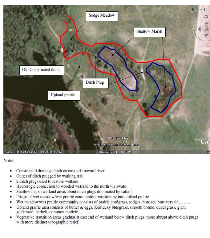
5 Report Figures Figures should include site boundaries, approximate scale, and north arrow YES NO 1 =3000 N
6 Report Results Describe the wetland type, dominant vegetation, soils, hydrology, and landscape position Describe the adjacent upland in terms of community type, vegetation, soils, and landscape position Describe the basis for the wetland delineation line, being specific on the transition
7 Text Examples Wetland Type &Vegetation: Wetland 1 is a Type 3 (PEMC/F) with an interior shallow marsh community surrounded by a fringe of wet meadow. Dominant vegetation in the shallow marsh includes broadleaf cattail, arrowhead, and water plantain. The wet meadow fringe include reed canary grass, blue vervain, green bulrush, and swamp milkweed with a few scattered willow shrubs.
8 Text Examples Upland Vegetation: The adjacent upland is a deciduous forest dominated by red oak and aspen in the overstory, American hazelnut and bush honeysuckle in the shrub layer, and a ground layer of enchanter s nightshade, cleavers, bracken fern, and sweet cicely.
9 Text Examples Vegetation Transition: The wetland-upland transition was relatively abrupt with a foot zone of transitional species including interrupted fern, bittersweet nightshade, common elder, and red-osier dogwood.
10 Text Examples Hydrology and Landscape Setting: The wetland is a isolated depression approximately 500 feet upslope from an extensive riverine floodplain. It sits roughly 5 feet higher in elevation than the adjacent floodplain and appears to be primarily surface-water driven based on the soils and watershed size The basin outlets to the south toward the floodplain via an intermittent drainageway. The basin appears to be semi-permanently flooded with 1-2 feet of surface water in the interior of the basin and an intermittently flooded/saturated fringe. Hydrology indicators A1, A2, B9, and C7 were observed along the wetland boundary.
11 Text Examples Soils: Soils in the wetland consisted of a deep layer of sapric material overlying fine sand consistent with the mapped soil unit. Indicator A1 was observed in the wetland. Adjacent upland soils lacked the organic surface layer and consisted of high chroma loamy fine sand over sand. No hydric soil indicators were observed in the upland.
12
13 Do s and Don'ts Don t load the report up with definitions and language from the Manual and regulatory program. Bigger is not necessarily better! Be concise and specific Make a clear distinction between what you observed and what your interpretation is of what you observed. Make sure your report addresses the whole site, not just parts of it. Knowing where the wetlands are not is just as important as knowing where they are. Keep any regulatory discussion separate from the technical portion of the report. Do a separate memo or report for the regulatory portion or add a regulatory discussion section at the end of the report.
Information for File # MMJ; Methodist Hospital Flood Storage Mitigation and Wetland Enhancement Project
 Information for File # 2016-01223-MMJ; Methodist Hospital Flood Storage Mitigation and Wetland Enhancement Project Applicant: Park Nicollet, Attn: Robert Riesselman Corps Contact: Melissa Jenny Address:
Horner-McLaughlin Woods: Soil Types
 Horner-McLaughlin Woods: Soil Types Not present at HMW Adrian Muck Conover Loam 0-4% Slopes Houghton Muck Miami Loam 2-6% Slopes Miami Loam 6-12% Slopes Miami Loam 12-18% Slopes t 0 0.125 0.25 Miles Mary
co co CT') {_!{ co ~ 3 0
 {_!{ co ~ 3 0") co ~ 3 0 co co CT') {_!{ This document is made available electronically by the Minnesota Legislative Reference Library as part of an ongoing digital archiving project. http://www.leg.state.mn.us/lrl/lrl.asp
co ~ 3 0 co co CT') {_!{ This document is made available electronically by the Minnesota Legislative Reference Library as part of an ongoing digital archiving project. http://www.leg.state.mn.us/lrl/lrl.asp
Site Preparation. What to Look for in a Vegetation Implementation Plan. Plant Community Goals (restoration checklist) Plant Community Goals
 Plant Community Goals") What to Look for in a Vegetation Implementation Plan Plant Community Goals (restoration checklist) Defining Project Goals Goals Site Preparation Mixes and Plant ing/planting Zone Map ing/planting Methods
What to Look for in a Vegetation Implementation Plan Plant Community Goals (restoration checklist) Defining Project Goals Goals Site Preparation Mixes and Plant ing/planting Zone Map ing/planting Methods
NEIGHBORHOOD WATER RESOURCES ENHANCEMENT GRANT OPPORTUNITIES
 VEGETATED BUFFER STRIPS A vegetated buffer strip is defined as an area of undisturbed vegetation abutting a pond, lake or wetland that is not mowed, cut or fertilized. It is left undisturbed to prevent
March 31, PENNDOT District Geerdes Road King of Prussia, PA Attn: Mr. Lawrence J. Link, P.E. Dear Mr. Link:
 March 31, 2002 PENNDOT District 6-0 7000 Geerdes Road King of Prussia, PA 17406 Attn: Mr. Lawrence J. Link, P.E. Re: S.R. 4005 and 4007, Sections 15P & 15B Germantown Avenue Reconstruction Project Letter
Wetlands (OR.WHERE NOT TO DUMP FILL!)
") Wetlands (OR.WHERE NOT TO DUMP FILL!) What is a Wetland? The US Army Corps of Engineers and US Environmental Protection Agency define a wetland as: Those areas that are inundated or saturated by surface
Wetlands (OR.WHERE NOT TO DUMP FILL!) What is a Wetland? The US Army Corps of Engineers and US Environmental Protection Agency define a wetland as: Those areas that are inundated or saturated by surface
Using Soil Attributes for HGM Wetland Classification
 Using Soil Attributes for HGM Wetland Classification Richard Weber Wetland Hydraulic Engineer Wetland Team CNTSC, Fort Worth, TX Slide 1 Hydrogeomorphic (HGM) Landscape Classes Originally for Development
Appendix A Functional Assessment for Potential Agricultural Agriculture Wetland Evaluation Bank Tool
 Appendix A Functional Assessment for Potential Agricultural Agriculture Wetland Evaluation Bank Tool BWSR Technical Guidance Version 1.0, June 26, 2013 This wetland functional assessment tool was developed
Caledon Villas Corp. c/o Mr. John Spina 55 Blue Willow Drive Woodbridge, ON L4L 9E8 May 14, Floodplain Characteristics, Old Church Road
 Caledon Villas Corp. c/o Mr. John Spina 55 Blue Willow Drive Woodbridge, ON L4L 9E8 May 14, 2013 Re: Floodplain Characteristics, Old Church Road This letter serves to confirm that I, Linda Sober, have
MEMORANDUM OF BOG TURTLE HABITAT INVESTIGATION
 MEMORANDUM OF BOG TURTLE HABITAT INVESTIGATION 410-728-2900 Fax: 410-728-3160 www.rkk.com To: From: CC: U.S. Fish and Wildlife Service, Pennsylvania Fish and Boat Commission Jennifer A Ottenberg Miller,
1/21/2014. Definitions vary widely Legal vs. functional Not always obvious. Wetlands are legally protected by Clean Water Act (1972)
") What is a Wetland? Freshwater Wetlands of Gulf Coast Plains Definitions vary widely Legal vs. functional Not always obvious What is a Wetland? Wetlands are legally protected by Clean Water Act (1972) Corps
What is a Wetland? Freshwater Wetlands of Gulf Coast Plains Definitions vary widely Legal vs. functional Not always obvious What is a Wetland? Wetlands are legally protected by Clean Water Act (1972) Corps
WASHINGTON COUNTY OREGON
 WASHINGTON COUNTY OREGON LONG RANGE PLANNING DIVISION North Bethany Subarea Stream Corridors: Existing Regulations In Oregon, there is a distinct difference between the land use rules that apply in rural
memo Project Name Little Lake Point Intercept Survey 2017 Date 9/5/17 To / Contact info Jerry Spetzman Cc / Contact info Greg Graske, PE
 memo Project Name Little Lake Point Intercept Survey 2017 Date 9/5/17 To / Contact info Cc / Contact info From / Contact info Regarding Jerry Spetzman Greg Graske, PE Joe Pallardy, Mike Majeski Little
Biodiversity Conservation
 Biodiversity Conservation and Site Plan Review Biodiversity conservation principles Threats to biodiversity Location of development Reviewing site plans Lunch Reviewing site plans (continued) LEED and
North Bellingham and Urban Growth Boundary Wetland, Stream, Habitat Conservation Area and Buffer Assessment TECHNICAL MEMORANDUM
 Northwest Ecological Services, LLC North Bellingham and Urban Growth Boundary Wetland, Stream, Habitat Conservation Area and Buffer Assessment TECHNICAL MEMORANDUM Prepared For: City of Bellingham Planning
This definition is from the Soil Science Glossary (Soil Science Society of America).
.") What is Soil? This definition is from the Soil Science Glossary (Soil Science Society of America). soil - (i) The unconsolidated mineral or organic material on the immediate surface of the earth that serves
What is Soil? This definition is from the Soil Science Glossary (Soil Science Society of America). soil - (i) The unconsolidated mineral or organic material on the immediate surface of the earth that serves
Habitat Improvements to the Motor Island Shoreline in the Upper Niagara River, NY: A Collaborative Approach
 Habitat Improvements to the Motor Island Shoreline in the Upper Niagara River, NY: A Collaborative Approach Edward Alkiewicz 1, Stephen Schoenwiesner 1, Jeff Gerlach 1, Morris Perot 2, Scott Ault 2, Mark
Information for File #MVP DAS
 Information for File #MVP201702209DAS Applicant: HyVee, Inc. Corps Contact: David Studenski Address: 1114 South Oak Street, La Crescent, Minnesota 559471560 EMail: david.a.studenski@usace.army.mil Phone:
Chagrin River Watershed Partners, Inc. Local Regulations. Amy H. Brennan (440)
") Chagrin River Watershed Partners, Inc. Local Regulations Amy H. Brennan (440) 975-3870 www.crwp.org abrennan@crwp.org July 9, 2013 Applicable Zoning and Building Codes Erosion and Sediment Control Grading
Chagrin River Watershed Partners, Inc. Local Regulations Amy H. Brennan (440) 975-3870 www.crwp.org abrennan@crwp.org July 9, 2013 Applicable Zoning and Building Codes Erosion and Sediment Control Grading
Using Soil Attributes for HGM Wetland Classification
 Using Soil Attributes for HGM Wetland Classification Richard Weber Wetland Hydraulic Engineer Wetland Team (Ret.) CNTSC, Fort Worth, TX Slide 1 Data Sources: Web Soil Survey County Scale Smaller than Reference
Richton Park Western Development Corridor Green Infrastructure Development Plan August 18, 2017
 Richton Park Western Development Corridor Green Infrastructure Development Plan August 18, 2017 Conservation Design Forum Geosyntec Consultants 403 W. St. Charles Road 1420 Kensington Road, Suite 103 Lombard,
Key Elements of Successful Conservation Planning. John Paskus October 17, 2013 Pierce Cedar Creek Institute Michigan Natural Features Inventory
 Key Elements of Successful Conservation Planning John Paskus October 17, 2013 Pierce Cedar Creek Institute Michigan Natural Features Inventory What is Conservation Planning? Pressey et al (2008): The process
The Tollgate Drain as built was $6.2 Million
 Case Studies Traditional Options Option 1 Take storm water to the south and outlet to the Red Cedar River. Cost about 23 million dollars. Option 2 Take storm water to the west and outlet to the Grand River.
Section 1 TABLE OF CONTENTS
 Section 1 TABLE OF CONTENTS... [M]ineral fertilizer is essential to feed around half of the world s population, and will be fundamental to ensure global food security through the 21 st century. 2013 U.N.
University of Florida Conservation Area Land Management Plan Solar Park Pond
 University of Florida Conservation Area Land Management Plan Solar Park Pond Introduction Solar Park Pond is an approximately 10.6-acre Conservation Area located on both sides of SW 23 rd Terrace, adjacent
Soil Colors, Texture & Structure
 Application Soil Colors, Texture & Structure Limiting conditions Soil color type/depth of system Bedrock type/depth of system Soil texture, structure, percolation rate size and type of system Sara Heger,
Phase 1 Habitat Replacement & Reconstruction
 Phase 1 Habitat Replacement & Reconstruction Marc Greenberg, USEPA greenberg.marc@epa.gov Hudson River EPA s Expectation of Habitat Reconstruction & Replacement provides diverse habitats Plants, plankton,
Level 1: GIS-based Desktop Assessments. Meghan Burns, Landscape Ecologist
 Level 1: GIS-based Desktop Assessments Meghan Burns, Landscape Ecologist EPA three-tier framework WETLAND AND RIPARIAN MAPPING LEVEL 1 LANDSCAPE ASSESSMENT WETLAND LANDSCAPE PROFILES LEVEL 2 RAPID ASSESSMENT
Prioritizing Tidal Wetlands: A Landscape Approach
 Prioritizing Tidal Wetlands: A Landscape Approach Laura Brophy Director, Estuary Technical Group Institute for Applied Ecology Corvallis, OR College of Earth, Ocean and Atmospheric Sciences, Oregon State
APPLICATION FOR REGULAR ZONING PERMIT
 Receipt No. Fee Date Date Permit Issued: Certificate of Compliance: Date Floodplain Zoning Permit: Date DOOR COUNTY LAND USE SERVICES 421 Nebraska Street Door County Government Center Sturgeon Bay, Wisconsin
Soil Properties That Distinguish Ecological Sites
 Soil Properties That Distinguish Ecological Sites Mike Duniway USGS-Southwest Biological Science Center Canyonlands Research Station Moab, UT mduniway@usgs.gov Spokane, WA January 31, 2012 Ecological Sites
Rain Garden Plant Selection
 Rain Garden Plant Selection Rain Garden Native Plants Blue Flag Bald Cypress Iris Cardinal Flower Ornamental Plants for the Rain Garden Check references for tolerance of wet and dry conditions. Consider
Custom Soil Resource Report Soil Map
 77 11' 22'' W Custom Soil Resource Report Soil Map 77 9' 43'' W 36 48' 13'' N 304700 304900 305100 305300 305500 305700 305900 306100 306300 306500 306700 306900 307100 36 48' 13'' N 36 47' 21'' N 4073800
Stormwater Standards. Clackamas County Service District No. 1. Planting Guide for Buffers
 Stormwater Standards Clackamas County Service District No. 1 APPENDIX B Planting Guide for Buffers Table of Contents Appendix B - Planting Guide for Buffers... Page B.1 General... 1 B.1.1 Introduction...
EPA Surface Water Enhancement, Restoration & Protection (SWERP)
") EPA Surface Water Enhancement, Restoration & Protection (SWERP) Clearinghouse Application Form 4.0004 wirerp"776- )11644141' For assistance with completing this form, please refer to the SWERP Clearinghouse
EPA Surface Water Enhancement, Restoration & Protection (SWERP) Clearinghouse Application Form 4.0004 wirerp"776- )11644141' For assistance with completing this form, please refer to the SWERP Clearinghouse
Response to Comments (July 28, 2010 Oregon City Determination of Application Completeness Memo)
") Environmental Science & Assessment, LLC MEMORANDUM DATE: August 13, 2010 TO: Oregon City Planning CC: Jill Long Lane Powell FROM: RE: Jack Dalton Response to Comments (July 28, 2010 Oregon City Determination
Environmental Science & Assessment, LLC MEMORANDUM DATE: August 13, 2010 TO: Oregon City Planning CC: Jill Long Lane Powell FROM: RE: Jack Dalton Response to Comments (July 28, 2010 Oregon City Determination
Pennsylvania Stormwater Best Management Practices Manual
 Pennsylvania Stormwater Best Management Practices Manual DRAFT - JANUARY 2005 Section 4 Comprehensive Stormwater Management: Integrating Site Design, Non-Structural, and Structural BMP's This page intentionally
Landscape Guidelines. Landscape type: Valley Pasture Character areas: Frome Valley Pasture Stour Valley Pasture. Landscape change
 Landscape type: Valley Pasture Character areas: Frome Valley Pasture Stour Valley Pasture The valley pasture landscape type is found along the lower reaches of the Stour and Frome, formed from alluvial
Grassland Vegetation Inventory, Site Type Examples for the Foothills Fescue Natural Subregion. Prepared by LandWise Inc., December 2006.
 Grassland Vegetation Inventory, Site Type Examples for the Foothills Fescue Natural Subregion. Prepared by LandWise Inc., December 2006. Northern Fescue Foothills Fescue Dry Mixedgrass Mixedgrass Mixedgrass
MEMORANDUM. September 10, 2018
 September 10, 2018 MEMORANDUM TO: Chad Bird, City of Decorah FROM: Larry Weber and Dan Gilles, Iowa Flood Center, IIHR Hydroscience & Engineering COPY TO: Dana Werner, St. Paul District Corps of Engineers,
Section 3 Non-Structural BMPs
 3.1 Stream Buffers A stream buffer or stream setback is a designated area around a stream, lake, or wetland left in a natural, densely vegetated state so as to protect the receiving water quality and provide
Overview of Soil Properties
 Willie Harris apatite@ufl.edu Acknowledgments: Wade Hurt Mike Vepraskas FAESS Soil Scientists Overview of Soil Properties Website to download files of talks: wgharris.ifas.ufl.edu.hsw.htm Meaning of Soil
Overview of Soil Properties
 Willie Harris apatite@ufl.edu Acknowledgments: Wade Hurt Mike Vepraskas FAESS Soil Scientists Overview of Soil Properties Website to download files of talks: wgharris.ifas.ufl.edu.hsw.htm Meaning of Soil
Plants for Rain Gardens and Pond Edges
 Plants for Rain Gardens and Pond Edges Marina D Abreau UF-IFAS Hillsborough County Extension Florida Extension Master Gardener Continued Training Conference October 26, 2010, 1:45 pm Outline for Today
Environmental Protection Ordinances (Performance Zoning) Bedminster Township, Bucks County
 Bedminster Township, Bucks County") Environmental Protection Ordinances (Performance Zoning) Bedminster Township, Bucks County ARTICLE VI. PERFORMANCE STANDARDS Section 600 Compliance All uses, activities, subdivisions and/or land developments
Environmental Protection Ordinances (Performance Zoning) Bedminster Township, Bucks County ARTICLE VI. PERFORMANCE STANDARDS Section 600 Compliance All uses, activities, subdivisions and/or land developments
Polpis Bike Path. General Impacts: 1.47 acres forested, marsh, shrub swamp
 Polpis Bike Path File No.: 199201570 City and State: Nantucket, MA General Impacts: 1.47 acres forested, marsh, shrub swamp Functions and Values Lost: (from EA/SOF) Floodflow Alteration Groundwater Discharge
Wisconsin Dept. of Transportation November 2017
 Wisconsin Dept. of Transportation November 2017 Jennifer Gibson WisDOT Environmental Coordinator Mike Helmrick WisDOT Environmental Coordinator Background on compensatory wetland mitigation Site purpose
50 Years of Habitat Change in the Mississippi River Delta
 50 Years of Habitat Change in the Mississippi River Delta Wells*, Chris, Larry Handley*, Jason Dugas**, Kelly Mouton**, Dennis Lichtenberg** *NWRC/USGS; **NWRC/IAP World Services U.S. Department of the
2017 Iowa FFA Soil Judging CDE Exam
 2017 Iowa FFA Soil Judging CDE Exam 1. Landscape positions vary in soil composition and makeup. What landscape position would be characterized by having strata and lenses of different textures in the profile:
When planning stormwater management facilities, the following principles shall be applied where possible.
 2.0 Principles When planning stormwater management facilities, the following principles shall be applied where possible. 2.0.1 Drainage is a regional phenomenon that does not respect the boundaries between
Oil Sands Reclamation From the Ground Up : A Suncor Energy Perspective
 Oil Sands Reclamation From the Ground Up : A Suncor Energy Perspective Lelaynia Cox, RPF and Cecilia Jeje, PhD College of Alberta Professional Forest Technologists April 14, 2011 Overview Oil sands mining
What s Working: Vegetation Establishment & Maintenance
 What s Working: Vegetation Establishment & Maintenance July 2016 Wetland Management 2016 Information The best wetland habitats for amphibians feature vegetation for concealment, foraging and egg-laying;
Lake Nokomis Shoreline Enhancement Project
 Lake Nokomis Shoreline Enhancement Project Community Meeting 2 February 13, 2018 Agenda Current Problems Project Goals Project Status Existing Conditions Community Input Draft Schematic Design Long-term
BLACK/HARMONY/FAREWELL CREEK WATERSHED EXISTING CONDITIONS REPORT CHAPTER 5 IMPERVIOUS SURFACES
 BLACK/HARMONY/FAREWELL CREEK WATERSHED EXISTING CONDITIONS REPORT CHAPTER 5 IMPERVIOUS SURFACES Draft November 2009 TABLE OF CONTENTS 1.0 INTRODUCTION... 3 2.0 STUDY AREA AND SCOPE... 4 3.0 METHODOLOGY...
Field Indicators of Hydric Soils in the United States: For All Soils. Field Indicators. Indicators for all soils regardless of texture
 Field Indicators of Hydric Soils in the United States: For All Soils From Vasilas, L.M., G.W. Hurt, and C.V. Noble. 2010. Field indicators of hydric soils in the United States (Version 7.0), USDA, NRCS,
Florida s Ephemeral Ponds and Pond-Breeding Amphibians
 Florida s Ephemeral Ponds and Pond-Breeding Amphibians What are Ephemeral Ponds? Ephemeral ponds are small, isolated wetlands that dry periodically. These ponds can be deep, sand-bottomed depressions with
2016 Iowa FFA Soils Evaluation CDE Exam
 2016 Iowa FFA Soils Evaluation CDE Exam 1. Which of the following is true regarding soil horizons? a. A horizon is darker in color and has more organic matter b. B horizon is darker in color and has more
Information for File # MHK
 Information for File #2014-03555-MHK Applicant: Corps Contact: Wimmer Communities Marie Kopka Address: 250 N. Sunnyslope Road, Suite 296 Brookfield, Wisconsin 53005 E-Mail: Marie.H.Kopka@usace.army.mil
TRCA Field Staking Protocol December 2016
 Page 1 of 6 TRCA Field Staking Protocol December 2016 This Protocol describes TRCA staff s current practice for field staking the physical top of bank, the physical toe of slope, and the limit of existing
Riparian Ecology and Plant Identification Ventura River and Casitas Springs Community Center Nov 7-8, 2007
 The CNPS Plant Science Training Program is proud to present a two-day Riparian workshop, at the, Casitas Springs (between Ventura and Ojai) Target audience: Professional and student botanists, biologists,
Maintaining Your Neighborhood Stormwater Facilities
 Maintaining Your Neighborhood Stormwater Facilities How to identify stormwater facilities and keep them working Layout by the Thurston County Storm and Surface Water Utility with thanks to the Delaware
** Ecological Sites tied to soil data accessible through Web Soil Survey
 Ecological Site: A distinctive kind of land with specific physical characteristics that differs from other kinds of land in its ability to produce a distinctive kind and amount of vegetation, and in its
Healthy Living Strategy: Shorelines
 Healthy Living Strategy: Shorelines Shoreline Vegetation in Muskoka The basis of a natural ecosystem is a complex combination of vegetation that forms canopy, understory, and herbaceous layers. It is easier
IOWA FFA STATE SOILS CDE SATURDAY, OCTOBER 13, 2007 AMES, IOWA
 IOWA FFA STATE SOILS CDE SATURDAY, OCTOBER 13, 2007 AMES, IOWA 1. Moderately sloping has what percent slope: a. 9-14% b. 2-5% c. 5-9% d. over 14% 2. Which of the following horizons is the loose underlying
DANE COUNTY COMPREHENSIVE PLAN 5-YEAR UPDATE. Madison Area Surveyors March 12, 2014 Resource Protection Corridors
 DANE COUNTY COMPREHENSIVE PLAN 5-YEAR UPDATE Madison Area Surveyors March 12, 2014 Resource Protection Corridors Resource Protection Corridors Part 1: Purposes and Concepts Resource Protection Corridors
TOWN OF BRIGHTON OPEN SPACE INDEX UPDATE ( ) SITE NO. 6 SITE NAME: Heberle Estate
 SITE NO. 6 SITE NAME: Heberle Estate") SITE NO. 6 SITE NAME: Heberle Estate I. LOCATION A. BOUNDARIES NORTH SOUTH EAST WEST Town of Penfield Browncroft Blvd. Irondequoit Creek Knollbrook Apts. B. SIZE: + 41 ACRES C. OWNERSHIP INFORMATION OWNERSHIP
SITE NO. 6 SITE NAME: Heberle Estate I. LOCATION A. BOUNDARIES NORTH SOUTH EAST WEST Town of Penfield Browncroft Blvd. Irondequoit Creek Knollbrook Apts. B. SIZE: + 41 ACRES C. OWNERSHIP INFORMATION OWNERSHIP
Custom Soil Resource Report for Southampton County, Virginia
 United States Department of Agriculture Natural Resources Conservation Service A product of the National Cooperative Soil Survey, a joint effort of the United States Department of Agriculture and other
Pennsylvania Stormwater Best Management Practices Manual. Chapter 4. Integrating Site Design and Stormwater Management
 Pennsylvania Stormwater Best Management Practices Manual Chapter 4 Integrating Site Design and Stormwater Management 363-0300-002 / December 30, 2006 Chapter 4 Integrating Site Design and Stormwater Management
Chapter 3 Site Planning and Low Impact Development
 CHAPTER 3 Site Planning and Low Impact Development Chapter 3 Site Planning and Low Impact Development 3.0 Introduction The City of Charleston requires that major residential, large commercial (>1 acre),
Wetlands by Leslie Cargile
 Name: by Leslie Cargile What do the bogs in Ireland, the marshes in South Carolina, and the swamps of Louisiana have in common? If you said they re all wetlands, you d be right! are any land that is flooded
Pike River Restoration Adaptive Design: Restoring Structure and Function in an Urban Floodplain - from cabbages to cordgrass
 Pike River Restoration Adaptive Design: Restoring Structure and Function in an Urban Floodplain - from cabbages to cordgrass Alice Thompson, PWS & Heather Patti, PWS Pike River Re-imaginedfrom Cabbage
Soils and their Relationship with Agriculture
 Soils and their Relationship with Agriculture Presentation created by Thomas Gallagher Modified by Hank Bignell Capital Area Agriculture and Horticulture Program Cornell University Cooperative Extension
Hydric Soils - Overview
 Hydric Soils - Overview The Hydric Soils section presents the most current information about hydric soils. It updates information that was previously published in "Hydric Soils of the United States" and
APPLICATION FOR REGULAR ZONING PERMIT
 DOOR COUNTY PLANNING DEPARTMENT 421 Nebraska Street Door County Government Center Sturgeon Bay, Wisconsin 54235 Phone: (920) 746-2323 - FAX: (920) 746-2387 APPLICATION FOR REGULAR ZONING PERMIT TO THE
Public Notice ISSUED: 7/30/2018 EXPIRES: 8/29/2018
 SPONSOR: Mark Prosser Public Notice ISSUED: 7/3/218 EXPIRES: 8/29/218 REFER TO: MVP-216-1916-LSP SECTION:44 - Clean Water Act 1. WETLAND COMPENSATORY MITIGATION BANK PROPOSAL 2. SPECIFIC INFORMATION SPONSOR
Appendix I West Brampton Watermain Natural Environment Report
 Appendix I West Brampton Watermain Natural Environment Report December 20, 2012 The Municipal Infrastructure Group Ltd 8800 Dufferin Street, Suite 200 Vaughan, Ontario L4K 0C5 Attention: Angela Carley
Information for File # ARC
 Information for File # 2015-02781-ARC Applicant Corps Contact Enbridge Energy, Limited Partnership Andrew R Chambers Address 600 South Lake Avenue, Suite 211, Duluth, MN 55802 E-Mail Andrew.R.Chambers@usace.army.mil
Landscape Conservation Design April, 2014
 Designing Sustainable Landscapes in the Northeast A project of the North Atlantic Landscape Conservation Cooperative & Northeast Climate Science Center Landscape Conservation Design April, 2014 Conceptual
Florida Forever Conservation Needs Assessment Overview Maps
 Florida Forever Conservation Needs Assessment Overview Maps Prepared by Florida Natural Areas Inventory, The maps in this document are derived from the Florida Forever Conservation Needs Assessment, an
Custom Soil Resource Report for Van Buren County, Iowa
 United States Department of Agriculture Natural Resources Conservation Service A product of the National Cooperative Soil Survey, a joint effort of the United States Department of Agriculture and other
Minnesota Department of Natural Resource - Natural Resource Guidance Checklist Conserving Natural Resources through Density Bonuses
 Minnesota Department of Natural Resource - Natural Resource Guidance Checklist Conserving Natural Resources through Density Bonuses NRDB Why Use Density Bonuses & This Checklist Local units of government
Incorporating Traditional Ecological Knowledge and Cultural Information Into Wetland Protection, Management, and Restoration - Tulalip Reservation
 Incorporating Traditional Ecological Knowledge and Cultural Information Into Wetland Protection, Management, and Restoration - Tulalip Reservation By Jonathan Hall, Wetland Biologist, Tulalip Tribes Weallup
SUBSURFACE DRIP DISPERSAL OF EFFLUENT for LARGE SYSTEMS. Presented by: David Morgan and Rodney Ruskin
 SUBSURFACE DRIP DISPERSAL OF EFFLUENT for LARGE SYSTEMS Presented by: David Morgan and Rodney Ruskin Program Map Making Program Soil Parent material, Relief, Time. Organisms, Color, Texture, Depth, Profile
Riverview Road Fort Washington, MD. 163 Waterfront Street, Suite #450 National Harbor, MD (301)
") Riverview Road Fort Washington, MD 163 Waterfront Street, Suite #450 National Harbor, MD 20745 (301) 750-7040 www.fleurdelisllc.com 1 Prepared by Monique Anderson Walker Principal +1 301-750-7040 Monique@FleurDeLisLLC.com
Riverview Road Fort Washington, MD 163 Waterfront Street, Suite #450 National Harbor, MD 20745 (301) 750-7040 www.fleurdelisllc.com 1 Prepared by Monique Anderson Walker Principal +1 301-750-7040 Monique@FleurDeLisLLC.com
Appendix 2.2: Hicks & Company Preliminary Field Investigations of WOTUS Memo
 Appendix 2.2: Hicks & Company Preliminary Field Investigations of WOTUS Memo 1504 WEST 5TH STREET AUSTIN, TEXAS 78703 TEL: 512 / 478.0858 FAX: 512 / 474.1849 January 8, 2018 To: Mr. Kane Carpenter Environmental
The Salt Marsh Advancement Zone Assessment of Connecticut
 The Salt Marsh Advancement Zone Assessment of Connecticut Front cover image: Salt marsh advancement zones in Stratford, CT from the Comprehensive Map Book of Stratford, CT. Table of Contents Introduction...
Information for File # ARC
 Information for File # 2017-03115-ARC Applicant Consultant Corps Contact Bob Manzoline St. Louis and Lake Counties Regional Rail Authority Natalie White Short Elliot Hendrickson (SEH) Inc. Andrew R Chambers
WQ-03 STORMWATER WETLAND
 Greenville County Technical Specification WQ-03 STORMWATER WETLAND 1.0 Stormwater Wetland 1.1 Description Constructing wetlands to treat stormwater runoff is an attempt to reproduce the excellent pollutant
New Tools for Land Management: A Quick Introduction to Ecological Site Descriptions
 New Tools for Land : A Quick Introduction to Ecological Site Descriptions Land management agencies have the job of managing natural resources for multiple uses in a sustainable manner. A sound understanding
FIGURE 1 PHOTOSTATION PHOTOGRAPHS, FORT ORD RARE PLANT SURVEY, OPERABLE UNIT 1. CH2MHILL. Photograph 1: View of access road, looking northeast.
 Photograph 1: View of access road, looking northeast. Photograph 2: View of access road, looking to the southwest. Note there are open areas with sandy soils with annual grasses and fi laree within and
Flat Lake, Highway 103, HADD Compensation Project (DFO HADD Authorization 03-G8-068): 2010 Vegetation Monitoring
: 2010 Vegetation Monitoring") Flat Lake, Highway 103, HADD Compensation Project (DFO HADD Authorization 03-G8-068): 2010 Vegetation Monitoring Year 5 Final Diane LaRue, Vegetation Consultant Environmental Services, NSTIR Monitored
Flat Lake, Highway 103, HADD Compensation Project (DFO HADD Authorization 03-G8-068): 2010 Vegetation Monitoring Year 5 Final Diane LaRue, Vegetation Consultant Environmental Services, NSTIR Monitored
Whole Landscape Hydrology: Application to Restore or Create Wetlands. Introduction SOLUTION
 Whole Landscape Hydrology: Application to Restore or Create Wetlands by: Wade Hurt, USDA, NRCS, NSSC/University of Florida and Jimmie Richardson, North Dakota State University. Problem: Wetland construction
Meeting Agenda. City of Guelph. River Systems Advisory Committee. Agenda Items. Item 1, 2 and 3. Item 4 Ward to Downtown Pedestrian Bridge
 Meeting Agenda City of Guelph River Systems Advisory Committee September 19, 2018 City Hall, Meeting Room B From 4:00 to 6:00 p.m. Meeting Chair: Mariette Pushkar Agenda Items Welcome to all Item 1, 2
FirstLight Power Shoreline Management Manual Sustainable Shoreline Designs: From Long Island to Lake Erie Webinar Series
 FirstLight Power Shoreline Management Manual Sustainable Shoreline Designs: From Long Island to Lake Erie Webinar Series Presented by Jason Williams, PLA, NCI February 19, 2017 Introduction Lakes (impoundments)
Soil & Site Evaluator - Need to Know
 Soil & Site Evaluator - Need to Know I. The professional will understand the factors of soil development and demonstrate their importance to site evaluations. A. Topography 1. Landscape & landform description
Hiawatha Drain County Drain or Habitat Restoration?
 Michigan Water Environment Association 2018 Conference June 25, 2018 Dana Burd, PE Melanie Manion, Ottawa County Natural Resources Supervisor Hiawatha Drain County Drain or Habitat Restoration? Joe Bush,
Soil & Site Evaluator - Need to Know
 Soil & Site Evaluator - Need to Know I. The professional will understand the factors of soil development and demonstrate their importance to site evaluations. A. Topography 1. Landscape description 2.
2018 Iowa FFA Soil Judging CDE Exam 1. Landscape positions characterizes the location of the soil on the landscape and identifies potential risks.
 2018 Iowa FFA Soil Judging CDE Exam 1. Landscape positions characterizes the location of the soil on the landscape and identifies potential risks. Which landscape position is considered the floodplain
Draft Rhode Island Stormwater Design and Installation Standards Manual
 Draft Rhode Island Stormwater Design and Installation Standards Manual Summary The May 2009 Public Review Draft version of the RI Stormwater Design and Installation Standards Manual consists of approximately