Port Lavaca Future Land Use
|
|
|
- Violet Carroll
- 6 years ago
- Views:
Transcription
1 Port Lavaca Future Land Use Introduction The City of Port Lavaca is beginning to see sustained growth, after many years of relative stable population. New single family homes, apartments, and businesses are locating within the City. This represents an opportunity for the City to define its future and chart how new development should occur. The goal of a Future Land Use Plan is to identify a vision of how the City should grow and develop policies that support that vision. Port Lavaca is fortunate to have a significant amount of undeveloped land within the current city limits. This means future development can occur in proximity to existing utility infrastructure, allowing the City to grow without extensive utility extensions. While the City does not have a Zoning Ordinance, it can use its subdivision authority, and this future land use plan, to ensure new development meets community goals. The goals outlined in this plan provide the framework for City leaders to make informed decisions, based on an agreed community vision, to ensure future development complements the character of Port Lavaca and benefits the entire community. Process The first step in developing the land use plan was a workshop with City staff. This workshop was an opportunity for staff to identify planned and proposed developments, planned infrastructure investments, road improvements, and other issues that will influence future development. This workshop resulted in a base map that was used in the Land Use Workshop. The base map provided a frame of reference to participants to understand existing conditions in Port Lavaca and expected changes in the next several years. The Land Use Workshop was an open workshop that included City Council members, Parks Board members, Planning Board, Port Commission, interested citizens and others. The workshop started with an overview of the base map and existing conditions in Port Lavaca, including current demographics and population projections. Participants also were given a brief introduction to what considerations developers and the City explore when planning new development. This includes a cost / benefit analysis, regulatory framework, potential market for what is being built, etc. The purpose was to ensure participants understood the implications of future growth and could be more informed as they were planning. After the education component, participants in small groups were provided a base map and instructed to draw their vision for future development in Port Lavaca. They were asked to lay out where new residential, commercial, industrial, and other uses should go, along with potential infrastructure improvements to support this growth. Five maps were created, and for the most part, they were all very similar in laying out the pattern for future development. Illustration 1 shows the consensus map developed from the workshop. This pattern of development ensures adequate land available for a healthy mix of uses, including residential from high end, waterfront homes, to apartments, as well as commercial and industrial uses. The definitions below detail what is shown on the Future Land Use Map. 1
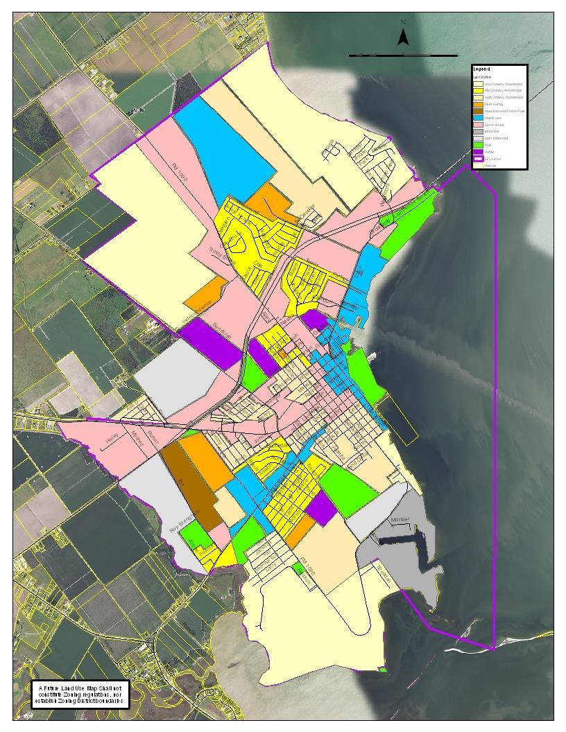
2 Illustration 1 2
3 Definitions Low Density Residential Single Family Homes with lot sizes over 9,000 sq ft Mid Density Residential Single Family Homes with lot sizes between 5,000 9,000 sq ft (Predominantly the existing homes in Port Lavaca) High Density Residential Single Family Homes on lot sizes below 5,000 sq ft, Patio Homes, Duplexes and Townhomes allowed on larger lots within these areas Multi Family Apartment complexes and Townhomes Manufactured Home Park Mixed Use multiple uses allowed including office, retail, high density residential, potential for mixed use buildings of retail and office on first floor, residential above Commercial Retail and commercial uses (restaurants, offices, shopping centers) Industrial Heavy Industrial uses, with some external impacts (high traffic, noise, odors, etc.) Light Industrial light industrial uses, with minimal external impacts (machine shops, etc.) Park Public Public Facilities, such as schools, wastewater plant, etc. Based on the workshop, a series of recommendations were developed to support the Future Land Use vision. These recommendations are intended to provide Port Lavaca leaders with the tools they need to implement the vision and guide growth appropriately. The recommendations include the following: Ensure adequate land reserved for industrial uses Ensure adequate park land to support new residential development Consider Design Guidelines for the Central Business District and Waterfront Utilize the Waterfront as a community asset Protect the Integrity of Residential Areas Develop Gateways marking entrance to the community For each recommendation, a series of actions steps was identified, providing City leaders with an understanding of how to implement the recommendations. This plan is intended as a working document, to guide City decision making, not simply gather dust on a shelf. The final step in the process is a public hearing, where the Future Land Use Plan is presented to the public for any final comments and input. It is important to recognize that the Future Land Use Plan is NOT zoning, and does not constitute regulatory authority to control land use. Rather, it is an advisory document for City leaders to use to facilitate decision making. It helps determine where future infrastructure investment should be made, and allows for more orderly development. The public hearing will be an opportunity to present the plan, and educate citizens on what it means and how it can help protect community quality of life and livability. 3
4 Recommendations Ensure adequate land reserved for industrial uses For the most part, cities see residential development followed by an increase in commercial and industrial growth. What often happens is that cities allow residential growth to occur throughout the City, and realize too late they no longer have adequate or appropriate land for industrial users. This results in a loss of new business, and jobs for residents. It is critical to ensure that land is identified and set aside for industrial uses. Port Lavaca is fortunate to have a significant property around Harbor Refuge that is City owned, served by rail and highway facilities, and already has existing industrial use. This property is a tremendous opportunity for the City to ensure land is available for prospective new businesses. The following are the actions the City can take to ensure adequate industrial properties in the future. o Provide adequate transportation access to areas identified for industrial uses o Ensure adequate infrastructure to support industrial uses o Ensure industrial development occurs with appropriate buffers, landscaping, setbacks, etc. to minimize negative impacts on neighboring properties Industrial uses generate significant traffic, and can create a burden on adjoining areas because of that traffic. Industrial users also prefer sites with easy access for their trucks. It is important for the City to coordinate transportation improvements with the Future Land Use plan to ensure adequate road access to industrial sites. As industrial development occurs, the City can coordinate with developers to add capacity as needed to support growth and ensure adequate access to industrial sites. Adequate utilities are needed to support industrial growth. The City must ensure it has adequate water and wastewater capacity to serve expected industrial growth. Port Lavaca is fortunate to have adequate water and wastewater at this time; however, as the community grows, it will be important to stay ahead of demand for these services. The Capital Improvement Plan is the tool for adequately preparing infrastructure for expected growth. The City s subdivision ordinance can be the tool to mitigate potential negative impacts from industrial development. The City can enforce setbacks and buffers that will minimize potential visual and noise impacts on adjoining properties. Landscaping is a tool that can create a visual barrier to industrial development and protect the integrity of adjoining properties. The City should review its ordinances to ensure proper setbacks and landscaping is in place for industrial uses. Ensure adequate park land to support new residential development The City has been proactive in establishing a park dedication section in its subdivision ordinance. This requires developers to donate property to the City for new parks as they develop residential subdivisions. This ensures that there will be new parks located in proximity to homes and presents a huge amenity for new residents. One challenge it can represent is that new parks require new facilities 4
5 to be built and increased maintenance over time. The City will have to ensure an adequate parks budget going forward to ensure park facilities are well developed and well maintained. There is more to a successful park system than just having many parks. These parks need to provide amenities and services desired by residents. The City should work closely with the Parks Board to identify what new facilities are needed and will serve residents. This identification will drive parks planning to ensure Port Lavaca parks meet the needs of existing and future residents. o Continue to utilize park set aside in development regulations to acquire new park land o Ensure adequate funding in budget to develop and properly maintains park facilities o Work with citizens to develop new park amenities to support diversity of activities (skate park, playgrounds, ball fields, picnic areas, pavilions, etc.) The City should work with developers to acquire new park land and ensure that new facilities are located in a way that best serve the community. There should also be a consideration of utilizing a fee in lieu option for developers to pay a fee instead of donating land for parks. The benefit of the fee in lieu is that it allows for investment in existing park facilities rather than simply acquiring more land when there may not be adequate funding to make needed improvements. The City should review its existing Park budget and ensure it is adequate to support existing and expected needs. This is an on-going challenge for communities to ensure adequate funding, especially as growth places new demands on the system. However, parks are a critical element in quality of life and should be a priority for funding to ensure they remain a community asset. The City should coordinate with its Park staff, Parks Board, and park users to identify needs and how to address them. As the community grows and changes, the demands for park amenities and services will change. The City must reach out to residents to identify their vision for the park system and their expectations. This will allow the City to target its resources on those most needed projects and ensure a park system that serves the community. Consider Design Guidelines for the Central Business District and Waterfront The Central Business District and Waterfront are two of Port Lavaca s greatest assets. They define the character and heritage of the community, and create the unique identity that can be lost to new development. Design guidelines are a tool that can be utilized to ensure new development, and redevelopment of existing buildings, is done in a way that protects the identity of these areas. Cities are spending millions of dollars creating faux downtowns that are an attempt to create an identity for their town. Port Lavaca already has that and needs to protect it. o Develop design standards that protect the unique character of these areas (buildings to the property line / street edge, wide sidewalks to allow for seating, etc.) o Consider building styles that complement the character of the community The first step in developing design standards should be identifying best practices from other communities similar to Port Lavaca. It is not necessary to reinvent the wheel; however, it is also not appropriate to simply adopt another community s standards. Collecting a good range of options will 5
6 allow the City to tailor a solution that best meets local issues and concerns. The City should work closely with property owners, developers, and others to develop standards that are appropriate, allowing for quality development that enhances the community. These standards should be rigorous enough to protect the character of the community, but not so onerous that they discourage redevelopment in the area. Utilize the Waterfront as a community asset As mentioned, the waterfront is a tremendous opportunity for Port Lavaca, both to attract new businesses and visitors. It will be important to establish clear goals for this area and support development that protects the character and integrity of the area. Port Lavaca should not attempt to recreate amenities from other places, rather it should use the authentic nature of its waterfront, with its mix of commercial, retail, public and residential uses as a calling card to establish its own unique identity. New development should not take away from this eclectic character, but enhance it, bringing complementary businesses that benefit from proximity to the shore, creating new markets for the shrimpers and oystermen. Having a real, working waterfront will attract people to Port Lavaca and represents a tremendous opportunity for economic development in Port Lavaca. o Create a destination on the waterfront through mixed use development that incorporates retail, restaurants, and residential uses where appropriate o Allow for industrial and commercial uses that require water access where appropriate (existing industrial area and commercial focused harbors) This element of the Plan will be primarily driven by private investment as developers see the value in Port Lavaca s waterfront and invest in the area. The City can support this effort by ensuring public space along the waterfront continues to be an attraction and asset for the area. As well, there may be an opportunity in the future for alternative funding mechanisms to support potential development, such as a Tax Increment Finance district that utilizes any additional tax revenue generated in an area to fund improvements in that area. TIF districts are not an additional tax, rather they utilize any increase in property values that occur as development happens to fund public improvements. The City is fortunate to have a number of water access points, which allows for a variety of uses where appropriate. Some are already used for industrial and commercial purposes, and the City should support their continued use in this fashion. These harbors are a critical component of economic development in Port Lavaca because of their accessibility to the water and rail. Protect the Integrity of Residential Areas A city should strive to protect the health and safety of residents, especially in their homes. This means that residential areas are insulated from issues like lighting overspill, noise, and traffic often generated by industrial and commercial uses. The origin of zoning was a response to the negative impacts of industry on peoples homes. There are many tools available to the city to minimize negative impacts from development. These offer alternatives to zoning that can be adopted to protect quality of life without being overly restrictive on development. Tools include landscaping, setbacks, lighting standards, etc. These all are ways to mitigate impacts of commercial and industrial growth and preserve residential property values and quality of life. 6
7 o o Promote landscaping and buffers between different land uses, particularly commercial and residential areas Consider lighting standards to minimize light pollution and light spill over onto neighboring properties The City can utilize its subdivision ordinance to regulate setbacks and landscaping to protect the integrity of residential neighborhoods from encroachment. There is also an opportunity to limit industrial and commercial lighting and minimize the spillover from these lights. Without Zoning, the City cannot strictly regulate where certain activities and land uses occur; however, there are opportunities to mitigate conflict between land uses through landscaping, setbacks, and lighting controls that the City can regulate. Develop Gateways marking entrance to the community The phrase, You don t get a second chance to make a first impression is as true for cities as it is people. The appearance of a community is a huge factor in whether or not people will stop, visit, and spend money in the town. Gateways and corridors serve as an opportunity to introduce the community image and brand to visitors and those passing by. Gateways are typically a distinct point, usually an intersection, at an entry point to the City. These can be designated with signage (as Port Lavaca has at US 87 and SH 35) and other distinct features. These serve as the introduction to the City and present that initial brand to visitors. Corridor development encompasses the activity along the transportation network. It is recommended that the major entry corridors into Port Lavaca (US 87, SH 35) receive a focus of attention to encourage attractive, welcoming development. If someone has to drive past a series of decaying strip malls, junk yards, etc. to reach the waterfront, this will negatively impact their opinion of Port Lavaca. Having attractive, well designed commercial and mixed uses along these primary corridors will make Port Lavaca more attractive to visitors and potential businesses. o Identify appropriate locations for gateways at key intersections o Develop signage, etc. to highlight the community o Consider design standards along key corridors into the community to ensure development is attractive and welcoming There are a few key intersections leading into Port Lavaca that can serve as gateways for the community. The City already has a large entry sign at US 87 and SH 35, which is the primary entry point. While TxDOT is very strict about what can go into the highway right of way, there may be an opportunity to add to this feature. Another option can be to utilize design guidelines to establish corridors along major thoroughfares to reinforce the gateway character. This would ensure new development adds to the quality and appearance of the community. These standards should reflect local aesthetics and concerns and balance the need for quality design with development concerns of cost and time. Signage is another opportunity to create a brand for the City. Street signs, banners, etc. can be utilized to convey a theme and enhance community appearance. This type of signage is often found in downtowns and along key corridors in communities. It communicates a sense of place and the unique identity of the community to passersby. The City should look to other communities for examples and develop a program that fits the local needs of Port Lavaca and its residents. 7
8 Conclusion Port Lavaca is taking a proactive step to determine its future and control its destiny. This Future Land Use Plan defines the community s vision for its future, and creates the framework for decision making to implement that Vision. It will be up to City leaders to take the specific actions needed to make the Vision a reality. This Plan provides the starting point, and recommendations on how to move forward, within the existing regulatory environment in Port Lavaca. 8
Visioning Statement and Guiding Principles
 Visioning Statement and Guiding Principles Planning for the Future The General Plan The General Plan represents Woodland's shared vision of the future and defines a path to lead the community toward its
Small Area Plan. South Gateway
 Small Area Plan Adopted May 12, 2008 South Gateway Purpose. The South Gateway Small Area Plan defines the City s expectations for the future of the southern entrance to the City at Interstate 85 and Highway
Mark-up of the effect of the proposed Bronte Village Growth Area OPA No.18 on the text of section 24, Bronte Village, of the Livable Oakville Plan
 Mark-up of the effect of the proposed Bronte Village Growth Area OPA No.18 on the text of section 24, Bronte Village, of the Livable Oakville Plan Notes: This document is provided for information purposes
EXISTING COMPREHENSIVE PLAN
 EXISTING COMPREHENSIVE PLAN Town Center Land Use Element: V. LAND USE POLICIES Town Center Mercer Island's business district vision as described in "Your Mercer Island Citizen-Designed Downtown" was an
SECTION II SECTION II STATEMENT OF GOALS, OBJECTIVES, PRINCIPLES, ASSUMPTIONS, POLICIES AND STANDARDS
 STATEMENT OF GOALS, OBJECTIVES, PRINCIPLES, ASSUMPTIONS, POLICIES AND STANDARDS 1 2 STATEMENT OF GOALS, OBJECTIVES, PRINCIPLES, ASSUMPTIONS, POLICIES AND STANDARDS INTRODUCTION The New Jersey Municipal
Urban Design Manual PLANNING AROUND RAPID TRANSIT STATIONS (PARTS) Introduction. Station Study Areas
 Introduction. Station Study Areas") 111111 PLANNING AROUND RAPID TRANSIT STATIONS (PARTS) Introduction The ION rapid transit system will link Waterloo, Kitchener and Cambridge through a central transit corridor (CTC). There are a number
111111 PLANNING AROUND RAPID TRANSIT STATIONS (PARTS) Introduction The ION rapid transit system will link Waterloo, Kitchener and Cambridge through a central transit corridor (CTC). There are a number
The transportation system in a community is an
 7 TRANSPORTATION The transportation system in a community is an important factor contributing to the quality of life of the residents. Without a sound transportation system to bring both goods and patrons
Implementation Guide Comprehensive Plan City of Allen
 Implementation Guide 2030 Comprehensive Plan City of Allen DRAFT 2015 Implementation Guide Allen 2030 Comprehensive Plan INTRODUCTION The Comprehensive Plan serves as a guide for the growth and development
Urban Planning and Land Use
 Urban Planning and Land Use 701 North 7 th Street, Room 423 Phone: (913) 573-5750 Kansas City, Kansas 66101 Fax: (913) 573-5796 Email: planninginfo@wycokck.org www.wycokck.org/planning To: From: City Planning
Planning Districts INTRODUCTION
 INTRODUCTION To facilitate detailed examination of development prospects for all areas of the community, Delano has been divided into 14 planning districts. The location of these planning districts is
V. Vision and Guiding Principles
 V. Vision and Guiding Principles The Master Plan for the Powers Ferry Corridor seeks a foundation in the desires of the community. At times, various elements of the community offered opposing viewpoints,
Town Center (part of the Comprehensive Plan)
") Town Center (part of the Comprehensive Plan) Mercer Island Town Center Looking North (2014) In 1994, a year-long process culminated in a set of design guidelines and code requirements for the Town Center
Town Center (part of the Comprehensive Plan) Mercer Island Town Center Looking North (2014) In 1994, a year-long process culminated in a set of design guidelines and code requirements for the Town Center
TOWN COUNCIL / PLANNING COMMISSION
 Workshop #3 TOWN COUNCIL / PLANNING COMMISSION January 20, 2011 Consultant Team In Attendance Tonight BMS Design Group Nevada City and San Francisco Michael Smiley, AICP, ASLA Partner-in-Charge Nancy L.
Downtown Whitby Action Plan
 Downtown Whitby Action Plan Final Report October 2016 Table of Contents Introduction 1 Public Consultation 2 Walkability 3 Downtown Whitby Walkability Map 4 Vision 5 Goal & Objectives 6 Objective 1 7 Objective
Policies and Code Intent Sections Related to Town Center
 Policies and Code Intent Sections Related to Town Center The Town Center Vision is scattered throughout the Comprehensive Plan, development code and the 1994 Town Center Plan. What follows are sections
EXECUTIVE SUMMARY DRAFT CHAPTER 1 INTRODUCTION EXECUTIVE SUMMARY
 CHAPTER 1 EXECUTIVE SUMMARY INTRODUCTION Through the joint efforts of the City of Tulsa planning staff and the Land Services division of Indian Nations Council of Governments (INCOG), the Berryhill Land
CHAPTER 3 VISION, GOALS, & PLANNING PRINCIPLES. City of Greensburg Comprehensive Plan. Introduction. Vision Statement. Growth Management Goals.
 CHAPTER 3 VISION, GOALS, & PLANNING PRINCIPLES Introduction The Greensburg Comprehensive Plan is intended as a working community document. A combination of long and short-term goals, this document is intended
Route 1 Corridor Study
 Route 1 Corridor Study Westbrook, Connecticut A Vision for the Connecticut Shoreline Public Informational Meeting July 28, 2015 Lower Connecticut River Valley Council of Governments Fitzgerald & Halliday,
Chapter 1: Introduction
 Chapter 1: Introduction The Penn Avenue Community Works Corridor Vision and Implementation Framework presents an integrated communitybased vision and a coordinated, long-term implementation framework for
Welcome to the Oakridge Centre Open House
 Welcome to the Oakridge Centre Open House Why is the City hosting this event? This open house is to inform you of a rezoning application submitted to the City of Vancouver to amend the existing CD-1 (Comprehensive
Sorted citizen input comments in review of Blount County plans July, August, and September 2007
 Sorted citizen input comments in review of Blount County plans July, August, and September 2007 The following presents sorted citizen input comments from three sessions held in July, August and September
2.0 AREA PLANS. Lakeside Business District. Lakeside Business District Land Use Categories:
 Lakeside Business District Lakeside Business District Land Use Categories: Campus Commercial Campus Commercial means a mixture of uses which includes corporate offices, office parks, hotels, commercial,
CONCLUSION AND IMPLEMENTATION
 Lisbon s Vision CONCLUSION AND IMPLEMENTATION 7 Lisbon residents clearly appreciate the character, amenities, and opportunities that define our community. This Plan of Conservation and Development identifies
Town of Peru Comprehensive Plan Executive Summary
 Town of Peru Comprehensive Plan Executive Communities that plan grow by choice, not by chance. A plan makes growth thoughtful, understandable, and predictable. A plan shows that a community is managing
CHAPTER 7: VISION AND ACTION STATEMENTS. Noble 2025 Vision Statement
 CHAPTER 7: VISION AND ACTION STATEMENTS This chapter presents the vision, policy and action statements that transform the comprehensive planning study, an analysis of Noble s past, future trends and community
PORT WHITBY COMMUNITY
 PORT WHITBY COMMUNITY SECONDARY PLAN UPDATE COMMUNITY IMPROVEMENT PLAN URBAN DESIGN GUIDELINES September 2015 DRAFT PROPOSED AMENDMENT NUMBER # to the Whitby Official Plan PURPOSE: The intent of this Amendment
Hibbing. Land Use. Hibbing Comprehensive Plan 8.1. Land Use
 Hibbing 8.1 Introduction 8.3 Information and Assessment 8.5-8.14 Recommendations 8.15-8.17 Implementation 8.18-8.19 8.2 Introduction Although land use was not identified as a discrete goal during the community
4- PA - LD - LIVELY DOWNTOWN. LD - Background
 4- PA - LD - LIVELY DOWNTOWN LD - Background The downtown has been the service centre for the community since the city s inception and the area continues to supply people with their personal services,
The Lower SaLuda Greenway
 The Lower SaLuda Greenway InITIaTIve a FLourIShInG Greenway. a hub For economic GrowTh. a ConneCTIon BeTween CoMMunITIeS. In April 2017 the Michael J. Mungo Foundation and Lexington County commissioned
Corridors. Re-vitalize our Corridors and Gateways
 Corridors Re-vitalize our Corridors and Gateways Artist s rendering from the 287 Strategic Plan, 2015 Corridors are the major throughways of Loveland but they also provide important commercial, community
hermitage town center
 hermitage town center A Community Vision prepared by Strada for The City of Hermitage and The Mercer County Regional Planning Commission January 2007 table of contents introduction 3 design principles
3. VISION AND GOALS. Vision Statement. Goals, Objectives and Policies
 Vision Statement Queen Creek s interconnected network of parks, trails, open spaces and recreation opportunities provide safe and diverse activities and programs that sustain its unique, small town, equestrian
Table L-1 Summary Action Strategy. Action Item Timing Status Responsible Agency
 CHAPTER 4: CIRCULATION ELEMENT ISSUE #1: MAJOR THOROUFARES AND TRANSPORTATION ROUTES A balanced transportation system for Fontana is provided that meets the mobility needs of current and future residents
CHAPTER 7: Transportation, Mobility and Circulation
 AGLE AREA COMMUNITY Plan CHAPTER 7 CHAPTER 7: Transportation, Mobility and Circulation Transportation, Mobility and Circulation The purpose of the Transportation, Mobility and Circulation Chapter is to
The Five Components of the McLoughlin Area Plan
 The Five Components of the McLoughlin Area Plan This documents contains the complete language of the five components of the McLoughlin Area Plan: The Vision Statement The Values The Guiding Principles
Comprehensive Plan. Faribault, Minnesota. Hoisington Koegler Group Inc. Claybaugh Preservation Architecture Inc. Howard R. Green Company Bonz/REA
 Comprehensive Plan Faribault, Minnesota Adopted by the Faribault City Council July 8, 2003 prepared for: prepared by: Hoisington Koegler Group Inc. Claybaugh Preservation Architecture Inc. Howard R. Green
Urban Design 9Identity
 Urban Design 9Identity URBAN DESIGN IDENTITY Urban design is about connecting people to their places through the built environment, nature, and overall urban form. Done well, it creates a memorable space
5.1 Site Plan Guidelines
 5. Community Core Guidelines Development of the Community Core will take place by plan of subdivision and site plan approval. It will occur in a phased manner that will reflect the timing of residential
Pedestrian and Bike Bridge LOGO
 6.2.2 Pedestrian and Bike Bridge The proposed pedestrian and bike crossing re-envisions the existing bridge at Pismo Creek on Cypress Street. The bridge is currently underutilized by vehicular through
SAN RAFAEL GENERAL PLAN 2040 INTRODUCTION AND OVERVIEW
 SAN RAFAEL GENERAL PLAN 2040 INTRODUCTION AND OVERVIEW Steering Committee Presentation February 14, 2018 Purpose of General Plan Guide land use and development decisions Coordinate transportation, infrastructure,
MAYFIELD WEST SECONDARY PLAN PHASE 2
 MAYFIELD WEST SECONDARY PLAN PHASE 2 Public Open House #3 February 25, 2010 Draft Preferred Land Use Scenario TOWN OF CALEDON PLANNING & DEVELOPMENT DEPARTMENT Open House Agenda TOWN OF CALEDON 1. Welcome
4. INDUSTRIAL 53 CASTLE ROCK DESIGN
 4. INDUSTRIAL 53 CASTLE ROCK DESIGN CASTLE ROCK DESIGN 54 4. INDUSTRIAL Overview Well-designed and attractive industrial centers are the product of blending economic realities with both functional and
CITY OF PUYALLUP. Background. Development Services
 CITY OF PUYALLUP Development Services 333 South Meridian Puyallup WA 98371 To: City Council From: Katie Baker, AICP, Planning Division Re: South Hill Neighborhood Plan Adoption Date: (Meeting date: February
City of Plattsburgh DRI: Downtown Streetscapes & Riverfront Access. Downtown Streetscape and Riverfront Access Design
 City of Plattsburgh DRI: Downtown Streetscapes & Riverfront Access Welcome Thank you for coming this evening. Agenda PART I - Project Context The Downtown Revitalization Program Our DRI Projects Other
TORTI GALLAS and partners, inc. How to Retrofit Your Suburb to Make a Downtown
 How to Retrofit Your Suburb to Make a Downtown April, 2010 Where to Start What should the Town look like? How do I attract new residents, businesses and visitors?? Should we preserve our heritage? How
Executive Summary. Parks and Recreation Plan. Executive Summary
 Parks and Recreation Plan Executive Summary The Whitemarsh Township Parks and Recreation Plan sets forth a vision for how Whitemarsh Township can provide a premiere parks and recreation system reflective
We are a determined group residents, industry, and government and by working together an incredible future lies ahead for Troy.
 PROPOSED EDITS TO COMPREHENSIVE PLAN April 5, 2018 Page Par Change Iv TOC Principle 2, page number is 3 should be 33 I Forward Par 3, delete Strike through: Troy is today experiencing 3 1.1 Par 3 change
CITY CLERK. Parkland Acquisition Strategic Directions Report (All Wards)
") CITY CLERK Clause embodied in Report No. 10 of the, as adopted by the Council of the City of Toronto at its meeting held on November 6, 7 and 8, 2001. 10 Parkland Acquisition Strategic Directions Report
CITY CLERK Clause embodied in Report No. 10 of the, as adopted by the Council of the City of Toronto at its meeting held on November 6, 7 and 8, 2001. 10 Parkland Acquisition Strategic Directions Report
City of Royalton Comprehensive Land Use Plan 2005 to Revision February 8, 2011
 City of Royalton Comprehensive Land Use Plan 2005 to 2015 2011 Revision February 8, 2011 PART ONE: INTRODUCTION TO THE COMPREHENSIVE PLAN 1.0 Purpose and Introduction The Comprehensive Land Use Plan provides
In surveys, Dallas residents say what they want to change most
 NEIGHBORHOODS ELEMENT In surveys, Dallas residents say what they want to change most in the city is its appearance they want it to look beautiful, with trees and pedestrian-friendly neighborhoods. The
Olde Towne Vision Plan
 Olde Towne Vision Plan Introduction In 2016, the City of Bellevue will complete its move of City offices from Olde Towne Bellevue to its new municipal complex on Wall Street. The City intends to sell its
Plano Tomorrow Vision and Policies
 Plano Tomorrow Vision and Policies PLANO TOMORROW PILLARS The Built Environment The Social Environment The Natural Environment The Economic Environment Land Use and Urban Design Transportation Housing
Further input invited as Colchester Growth Strategy nears final phase
 IUE 3 / NOVEMBER 2015 Further input invited as Colchester Growth trategy nears final phase trathcona County is seeking public feedback as it enters the final phase of work on a Growth Management trategy
Citizen Advisory Group Meeting 5: Land Use April 14, 2011
 Citizen Advisory Group Meeting 5: Land Use April 14, 2011 Meeting Agenda 1. Background Review 2. Transportation Follow-up 3. PED Overlay Approach 4. Land Use Mapping 5. Group Exercise 6. Wrap-up and Next
S A C R A M E N T O C O U N T Y JACKSON HIGHWAY & GRANT LINE EAST VISIONING STUDY
 JACKSON HIGHWAY & GRANT LINE EAST S A C R A M E N T O C O U N T Y P L A N N I N G D E P A R T M E N T SUMMARY AND WORKBOOK November 19, 2008 History of the Visioning Study Sacramento County has two growth
Chapter 1.0 Introduction
 Chapter 1.0 Introduction 1.1 Background The North Metro commuter rail line is part of the RTD FasTracks regional transit system expansion program to build more than 100 miles of rail transit throughout
Town of Cobourg Heritage Master Plan. Statutory Public Meeting
 Town of Cobourg Heritage Master Plan Statutory Public Meeting April 25 th 2016 Presentation Overview 1. Introduction 2. Project background and schedule overview 3. Review of strategic direction content
City of Farmington. Downtown Plan. Amendment to the 1998 Master Plan Adopted October 11, 2004
 City of Farmington Amendment to the 1998 Master Plan Adopted October 11, 2004 Introduction Planning Background 1 Scope and Components of the Plan Amendment 2 Concept Introduction 3 Plan Concepts 3 Conceptual
4.1.3 LAND USE CATEGORIES
 4.1.3 LAND USE CATEGORIES a. City Center District The City Center District incorporates the existing character and mix of uses in downtown Belmont to encourage redevelopment and new development in keeping
Status Update (2006 vs. Now) Citizen s Advisory Committee February Plan for Prosperity
 Citizen s Advisory Committee February Plan for Prosperity") Status Update (2006 vs. Now) Citizen s Advisory Committee February 2018 Plan for Prosperity 2000 2017 2000 2017 Gardnerville Population 6,000 5,760 5746 5,500 5,000 5,067 5,550 5,165 5,394 5,412 5,250
Status Update (2006 vs. Now) Citizen s Advisory Committee February 2018 Plan for Prosperity 2000 2017 2000 2017 Gardnerville Population 6,000 5,760 5746 5,500 5,000 5,067 5,550 5,165 5,394 5,412 5,250
A. WHAT IS A GENERAL PLAN?
 I. Introduction A. WHAT IS A GENERAL PLAN? A general plan is the planning guideline for the future of a city. It contains goals and policies which regulate urban development, the protection of the natural
Sheridan Boulevard S TAT I O N A R E A P L A N S H E R I D A N B O U L E VA R D S TAT I O N A R E A P L A N
 Sheridan Boulevard S TAT I O N A R E A P L A N 1 City of Lakewood Adopted November, 2006 S H E R I D A N B O U L E VA R D S TAT I O N A R E A P L A N The Vision The City of Lakewood s overall vision is
2017 STRATEGIC PLAN CITY OF ST. AUGUSTINE
 2017 STRATEGIC PLAN CITY OF ST. AUGUSTINE WHO WE ARE CITY OF ST. AUGUSTINE VISION St. Augustine will be a diverse, livable, authentic waterfront city that builds upon its rich history and environment to
SQUAMISH 2010 AND BEYOND COMMUNITY VISION
 Our plan has been imagined and created to be both pragmatic and visionary. At the core of the strategy is a consideration of the highway s role and its impact on the community. First and foremost in creating
WATERFORD Plan of Preservation, Conservation and Development Supplement Part 1 - Policy Element
 WATERFORD 2012 Plan of Preservation, Conservation and Development 2015 Supplement Part 1 - Policy Element Effective June 11, 2015 2015 Plan Update GOAL To respond to the evolving land use needs and continually
Downtown Dubuque...it s a great time.
 Downtown Dubuque...it s a great time. Your timing could not be better to invest in Downtown. With hundreds of millions in public and private investment occurring on the City s downtown waterfront, millions
Executive Summary. NY 7 / NY 2 Corridor
 Executive Summary NY 7 / NY 2 Corridor Transportation and Land Use Study December 2005 Prepared for: Town of Colonie Capital District Transportation Committee Prepared by: Introduction: Land use decisions
Section 4 BUILDING THE MASTER PLAN
 The Master Plan 33 Section 4 BUILDING THE MASTER PLAN Figure 4:1. A collaborative effort characterized the two design workshops sponsored by DISC to create hypothetical Master Plans for the Towers Property
DRAFT PLAN PRESENTATION
 DRAFT PLAN PRESENTATION 1.23.2018 AGENDA Process Project Schedule Results from Visioning Workshop Draft Plan Highlights Concept Plans Feedback Next Steps PROJECT SCHEDULE KICK-OFF WORKSHOP August 29 th
38 Queen s University Campus Master Plan Part 1
 38 Queen s University Campus Master Plan Part 1 46 The Campus at the City Scale Chapter 4 The Campus at the City Scale 39 Queen s is an urban University centrally located in Kingston. Decisions made by
THEMES, VISION, + PRINCIPLES
 CHAPTER 2: THEMES, VISION, + PRINCIPLES This page intentionally left blank. 20 VISION DRAFT AUGUST 2018 2 2 THEMES, VISION, + GUIDING PRINCIPLES The Key Themes, Vision, and Guiding Principles presented
City of Long Beach. creating vibrant and exciting places
 City of Long Beach creating vibrant and exciting places Land Use Element Urban Design Element Overview of the two draft General Plan elements Discuss areas of change Economic goals of the plans Case study
Anatomy of A Vibrant Downtown. Anatomy of a Vibrant Downtown
 Anatomy of A Vibrant Downtown The goal of MAIN ST. REVITALIZATION PLANNING is to provide a framework that will help transform your downtown into a VIBRANT DOWNTOWN a place where people love to LIVE, WORK,
COMMUNITY DESIGN. GOAL: Create livable and attractive communities. Intent
 COMMUNITY DESIGN Intent An attractive, well-designed County will attract quality development, instill civic pride, improve the visual character of the community, and create a strong, positive image for
Future Land Use SAMPLE RECOMMENDATIONS
 SAMPLE RECOMMENDATIONS Future Land Use The Future Land Use Chapter of the Master Plan builds upon prior chapters examining the existing conditions in their respective topic areas to present a comprehensive
Official Plan Review
 Official Plan Review Summary Report - The Built Environment August 2014 Part 1: Introduction Planning for a healthy, prosperous and sustainable community is an important goal for our municipality. From
7Page 91 CLEMMONS COMMUNITY COMPASS 7 COMMUNITY CHARACTER
 7 Community Character The beauty of Clemmons won t necessarily be a reflection of our past, but our future. This quote from Comprehensive Plan Steering Committee member Wayne Dodson captures the essence
Concord Community Reuse Project Goals and Guiding Principles. Overarching Goals (OG)
") Concord Community Reuse Project Goals and Guiding Principles Overarching Goals (OG) No priority is implied by the order of presentation of the goals and guiding principles. Overarching goals for the Concord
Concord Community Reuse Project Goals and Guiding Principles Overarching Goals (OG) No priority is implied by the order of presentation of the goals and guiding principles. Overarching goals for the Concord
St. Louis Park Wooddale LRT Station Site development guidelines
 St. Louis Park Wooddale LRT Station Site development guidelines November 2013 OVERVIEW St. Louis Park s convenient location as a neighbor to Minneapolis means you re only minutes away from some of the
MEMO 1. INTRODUCTION PURPOSE & PROCESS REQUEST
 MEMO Date: August 22, 2017 To: Board of Commissioners From: Jason Burdette, Planning Director Re: Davidson Commons East Hotel Stakeholder Feedback 1. INTRODUCTION PURPOSE & PROCESS This memorandum summarizes
MEETING PURPOSE AND OVERVIEW
 MEETING PURPOSE AND OVERVIEW On February 23, 2012, the City of Elk Grove hosted the first of two community workshops related to the Southeast Policy Area. The workshop was held from 6:00 8:30 p.m. in the
Joint Study Session of the Sutter County. March 2, 2009
 Joint Study Session of the Sutter County Board of Supervisors and Planning Commission March 2, 2009 CURRENT APPLICATION General Plan Amendment Specific Plan Specific Plan Appendices Utility Plans Transit/AQ
Sherri Ferguson. President/CEO Portland Chamber of Commerce. Tennessee Certified Economic Developer Capstone Project
 Sherri Ferguson President/CEO Portland Chamber of Commerce Tennessee Certified Economic Developer Capstone Project Strategic Plan Development for the North Gateway of Portland, Tennessee The New Gateway
Gloucester County s Comprehensive Plan. The Community Connection
 Gloucester County s Comprehensive Plan The Community Connection Current Comp Plan Adopted in 1991 with a 20 year planning horizon Updated in 1995 with Part V- Implementation Recommendations and Appendix
New-Cast Mixed-use Development Proposal King Street West, Newcastle, Ontario
 URBAN DESIGN BRIEF New-Cast Mixed-use Development Proposal King Street West, Newcastle, Ontario TABLE OF CONTENTS: 1.0 Executive Summary 2.0 Creating Vibrant and Sustainable Urban Places: Excerpts from
Chapter 4 Urban Design Element
 Chapter 4 Urban Design Element "The general tenor of the responses indicates a strong preference to not allow low-intensity development into natural areas, resource lands or highly visible open space.
BROOKLYN PARK / 85TH AVE LRT STATION CDI DEVELOPMENT GUIDELINES DRAFT
 August 2018 Page intentionally left blank The Brooklyn Park Library adjacent to the 85th Ave LRT Station Area. OVERVIEW The Blue Line LRT Extension / Bottineau corridor offers a unique opportunity to leverage
SECTION ONE: INTRODUCTION. introduction
 introduction 1 INTRODUCTION Since it was first established in 1843 as a trading post for the Hudson s Bay Company, Victoria has evolved into a Provincial capital city that is recognized across Canada and
THE POLICY FRAMEWORK FOR WALKABLE COMMUNITIES. Community Technical Assistance Program Building Active Communities Institute March 2016
 THE POLICY FRAMEWORK FOR WALKABLE COMMUNITIES Community Technical Assistance Program Building Active Communities Institute March 2016 ACTIVE COMMUNITIES BACK THEN ACTIVE COMMUNITIES BACK THEN Lifestyle
The Cambie Corridor 2015 Fall workshop series. What we heard WORKSHOP OUTLINE
 The Cambie Corridor 2015 Fall workshop series W 16 AVE Area 5 CAMBIE CORRIDOR Phase 3 What we heard ovember 21, 2015, 9am-noon, 1:30-4:30pm Peretz Centre 89 Participants* WORKSHOP OUTLIE Introductions
SOUTH NATOMAS COMMUNITY PLAN
 SOUTH NATOMAS Community Plan Part Three : COMMUNITY PLAN AREAS AND SPECIAL STUDY AREAS SACRAMENTO 2030 GENERAL PLAN Contents Community Location... 3-SN-3 Community Vision... 3-SN-4 Community Profile...
Corridor Vision. 1Pursue Minnehaha-Hiawatha Community Works Project. Mission of Hennepin County Community Works Program
 1Pursue Minnehaha-Hiawatha Community Works Project Minnehaha-Hiawatha Community Works is a project within the Hennepin Community Works (HCW) program. The mission of the HCW program is to enhance how the
Table of Contents. Elm Avenue Improvement Plan City of Waco, Texas. Introduction 1. Existing Context 1 Figure 1 2.
 Table of Contents Introduction 1 Existing Context 1 Figure 1 2 Plan Guidelines 3 Future Urban Form 4 The West-End 4 Main Street 6 The East-End 7 Figure 2 9 Public Improvement Recommendations 7 General
Animating the Rideau Canal December 2013
 Executive Summary Animating the Rideau Canal December 2013 Why study the Rideau Canal? The Rideau Canal has been an important part of Ottawa throughout its history, and has shaped and been shaped by the
MONTGOMERY COUNTY METRO STATION AREA DESIGN CHARRETTE
 MONTGOMERY COUNTY METRO STATION AREA DESIGN CHARRETTE Shady Grove Metro Station Area Charrette Closing Presentation October 25-28, 2000 MONTGOMERY COUNTY, MD M-NCPPC Design Collective, Inc. Architects
India Basin/Hunters Point Shoreline Community Workshop May 21, 2008
 India Basin/Hunters Point Shoreline Community Workshop May 21, 2008 Workshop Agenda Welcome Process Overview Context & Existing Conditions Presentation of Draft Concepts Land Use and Open Space Priorities
Joint Meeting City Council and the Plan Commission. September 1st, 2015
 Joint Meeting City Council and the Plan Commission September 1st, 2015 1 The City Plan Commission shall recommend a City Plan for the physical development of the City Article IX Section 2 of the City of
Municipal Development Plan. Summer Village of ROCHON SANDS. Bylaw #241-18
 Municipal Development Plan Summer Village of ROCHON SANDS Bylaw #241-18 TABLE OF CONTENTS PART ONE: BACKGROUND AND PURPOSE 3 SECTION 1: BACKGROUND 3 SECTION 2: GOALS AND POLICIES 3 PART TWO: PHYSICAL ENVIRONMENT
section five BEAUTIFICATION PLAN
 section five BEAUTIFICATION PLAN BEAUTIFICATION PLAN Section Five Beautification Plan The goal of the Beautification Plan is to improve the Route 8-Sunnyland Corridor in terms of aesthetics and to create
Scope of Services. River Oaks Boulevard (SH 183) Corridor Master Plan
 Corridor Master Plan") Scope of Services River Oaks Boulevard (SH 183) Corridor Master Plan PROJECT AREA The project area consists of the River Oaks Boulevard (SH 183) corridor bounded by SH 199 at the northern end and the Trinity
Scope of Services River Oaks Boulevard (SH 183) Corridor Master Plan PROJECT AREA The project area consists of the River Oaks Boulevard (SH 183) corridor bounded by SH 199 at the northern end and the Trinity