WATERFRONT PLACE CENTRAL MIXED USE REDEVELOPMENT PROJECT
|
|
|
- Tabitha Lane
- 6 years ago
- Views:
Transcription
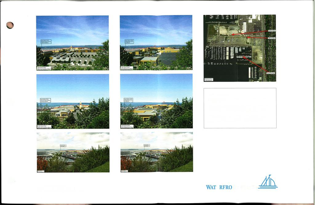
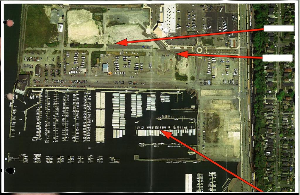
1 WATERFRONT PLACE CENTRAL MIXED USE REDEVELOPMENT PROJECT View Impact Analysis - Summary Narrative The view impact analysis conducted for the Waterfront Place Central mixed-use redevelopment project proposal was prepared by the Design Visualization division of the Parsons Brinkerhoff consulting firm. This same firm prepared the visual impact analysis the Port Gardner Wharf (North Marina) redevelopment project proposal approved by the Everett City Council in The same view impact analysis methodology was used for both proposals. The new visual impact analysis provides a comparison of the visual impacts of the current Waterfront Place Central proposal with those generated by the approved 2005 Port Gardner Wharf redevelopment plan. Basic Methodology Step 1 Site Photography: Photography of the project site from three key locations along the bluff overlooking the site (please refer to the site aerial photo reference map). The locations, camera lenses, and focal lengths are documented. Step 2 Data Collection: Collect the survey, site and building information. This was taken from several sources such as: Geographic information systems (GIS) data for existing buildings and site layout Engineering drawings of the roads, sidewalks, and infrastructure Two-dimensional architectural Computer Aided Drafting and Design (CADD) data of the building structures (in the case of the 2005 Port Gardner Wharf design) Three-dimensional Sketch-up models (in the case of the 2014 Waterfront Place design) Step 3 3D Computer Model: Based on the CADD plan drawings and/or Sketch-up models, an accurate three-dimensional computer model with volumetric shapes at the correct heights is built. For the buildings in the foreground, additional architectural details and suggestive finishes are included. Road and sidewalk details and the basic landscape are also added per plan. Step 4 View Matching: For each photograph, the two-dimensional CADD data of the existing condition is imported. The software used allows the location, camera lens, focal length and height to be entered as a starting point. The computer data is then matched to existing buildings and landmarks. Once the existing data is accurately aligned, the new proposed elements are imported as an individual layer on top of the existing data. Step 5 Lighting and Retouching of Photographs: The light source is matched for the time of day and longitude/latitude location of the site. The 3D model is rendered and composited onto the original photography with foreground and background elements properly masked. Page J-1
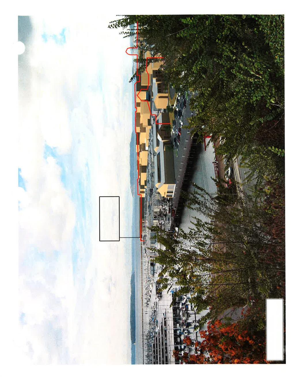
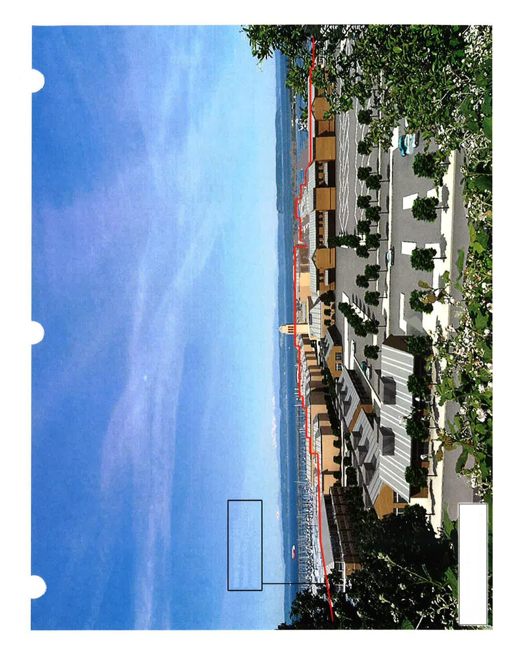
2 Comparison of Waterfront Place Central and Port Gardner Wharf View Impacts (based on the visual impact analysis images prepared by Parsons Brinkerhoff in 2005 and 2014) The North Marina Redevelopment Project (NMRP) Final Environmental Impact Statement (FEIS) included a detailed visual impact analysis for a very similar mix of 45- to 65-foot-high mixed-use buildings compared to those proposed in the current Waterfront Place Central project. They were also to be located on very similar portions of the site in its tallest buildings site plan alternative (sub-alternative 1B). The 2014 visual impact analysis prepared for the current proposal uses the same 2005 analysis view point locations, methodology, and consultants as described above. The only discernible differences between the taller building footprints and heights in the 2005 redevelopment plan Alternative 1B with those in the current Waterfront Place proposal involve: (1) a small shift of the building footprints for some of the central core 55- and 65-foot-high buildings in the current proposal 80 feet north of the footprints for the same height buildings in the original 2005 proposal, (2) a small shift of the building footprints for some of the 45-foot-height buildings in the current proposal approximately 50 to 100 feet closer to the Central Marina shoreline, and (3) a small reduction in the 45-foot height zone designated area adjacent to West Marine View Drive at the southeast corner of the site in the current proposal. Please also refer to Sheet 2.4, Height Zones, in Attachment B of the current proposal s Environmental Checklist for a more detailed comparison of the existing 2005 site plan height zone map with the proposed 2014 site plan height zone map. The current proposal removes the 13th Street view corridor provided by the three 2005 redevelopment site plan alternatives. However, the 2005 redevelopment plan alternative plan eventually selected for implementation (sub Alternative 1B), raised the elevation of the central 10-acre portion of the site by 10 to 15 feet to provide for extensive understructure parking. This multi-acre raised area included the full width of the proposed 80-foot wide 13th Street view corridor for most of its more than 800 foot length. This added height increase combined with the new trees and landscaping proposed for the parking structure roof terrace in this view corridor would have obstructed all views of the Snohomish River Channel for motorists, cyclists and pedestrians using West Marine View Drive and the initial gateway portion of 13th Street in the project site. As shown by Figure 5-10 in Chapter 5.4 Visual Quality of the NMRP 2005 FEIS, mature 35-foot-high landscape trees located on the 10- to 15-foot-high raised 13th Street View Corridor parking structure podium would also obstruct much of the narrow slot view of the Snohomish River Channel and Jetty Island for the limited number of Grand Avenue residents whose homes align with that view corridor. The new view analysis conducted for the current proposal also confirms (see images attached) the current proposal will not create any additional significant obstruction of the extensive water, mountain, island, peninsula, and territorial views currently enjoyed by existing bluff residents, compared to the 2005 redevelopment plan preferred alternative. In fact, these view analysis images confirm that the current proposal will provide a slight net reduction in the obstruction of views of the Central Docks portion of the marina compared to the 2005 redevelopment plan preferred alternative, from the 12th Street and 13th Street bluff viewpoints. Page J-2
3 The NMRP 2005 FEIS identified a variety of viewer groups that would be affected by site redevelopment for this proposed project also known as the Port Gardner Wharf project when it was finally approved by the Everett City Council at the end of These viewer groups included residents near the project site, motorists, cyclists, and pedestrians using adjoining portions of West Marine View Drive as well as project visitors, businesses, employees, boaters, and future residents. The FEIS concluded that most viewers would likely perceive the change from an older, unorganized industrial and boat repair area to a revitalized mixed-use urban community as a positive change and visual improvement. It noted that that many new project residents would have extensive water, mountain, island, peninsula and/or territorial views and that all other user groups of the completed project would have similar views from many site locations including its entire site perimeter. The current Waterfront Place Central proposal is anticipated to create a very similar positive change and visual improvement for the entire site. Based on the 2005 visual analysis prepared by Parsons Brinkerhoff, the FEIS also concluded that new larger buildings in the 2005 approved site redevelopment plan would obstruct small portions of the near shore views of the North Marina (now renamed Central Docks) marina basin, 12th Street Waterway (now renamed North Docks) and/or Snohomish River Channel for existing residents located east of the site. Consistent with the 2005 approved site redevelopment plan, the easternmost 45-footheight, 55-foot-height, and 65-foot-height buildings in the current proposal would be located approximately 300 feet, 900 feet and 1,200 feet west, respectively, of the closest single family residences located on Grand Avenue. These distances will significantly aid in minimizing any potential view obstruction to a very small percentage (well under 10 percent) of the total water, mountain, island, and peninsula view from any potentially affected nearby residence. This conclusion is supported by the new view analysis images prepared by Parsons Brinkerhoff in 2014, which are attached to this summary narrative. This is also consistent with the 2005 plan s FEIS analysis that the tallest buildings in the 2005 preferred site plan alternative would obstruct only a very small percentage of the broad expanse of the westward water, mountain, island, peninsula and territorial views currently enjoyed by many residents located east of the site. Moreover, this very small percentage obstruction calculation did not include the significant amount of these residents additional broad expanse of northwestern water, mountain, island, and peninsula view area on the north side of the site that would not be impacted at all by the 2005 project proposal or the current proposal. These 2014 view impact analysis images also confirm that there is a very substantial similarity between the current proposal s height zone map and mix of same height tall buildings and the height zone map and building mix contained in the existing approved 2005 site plan highest-density alternative (sub-alternative 1B). For all of the previously cited reasons, the current Waterfront Place Central proposal is not anticipated to create any view obstructions or other adverse visual impacts more significant or noticeably different than those already identified and evaluated by the NMRP 2005 FEIS or by the 2014 visual impact analysis prepared by Parsons Brinkerhoff. Page J-3
4


5
6
7
8
9

10
11
ARLINGTON COUNTY, VIRGINIA
 ARLINGTON COUNTY, VIRGINIA County Board Agenda Item Meeting October 15, 2005 DATE: September 28, 2005 SUBJECT: Request to Advertise the adoption of the 2005 Clarendon Sector Plan C. M. RECOMMENDATION:
Workshop 3. City of Burlington Waterfront Hotel Planning Study. September 14, The Planning Partnership
 Workshop 3 City of Burlington Waterfront Hotel Planning Study September 14, 2017 The Planning Partnership The Waterfront Hotel Planning Study 01 The Brant & Lakeshore Planning Study will establish a Strategic
City of Farmington. Downtown Plan. Amendment to the 1998 Master Plan Adopted October 11, 2004
 City of Farmington Amendment to the 1998 Master Plan Adopted October 11, 2004 Introduction Planning Background 1 Scope and Components of the Plan Amendment 2 Concept Introduction 3 Plan Concepts 3 Conceptual
This Review Is Divided Into Two Phases:
 Semiahmoo Town Centre Review The purpose of this review: To review the Semiahmoo Town Centre Concept Plan, originally approved in 1993, to ensure that this centre will continue to serve the needs of South
City Center Neighborhood Plan
 [1] City Center Neighborhood Plan As adopted by Ordinance No. 2014-09-049 and amended by Ordinance Nos. Formerly CBD Neighborhood as adopted by Ordinance No. 8868 and amended by Ordinance Nos. 8946, 9693,
Visual and Aesthetic Resources
 Visual and Aesthetic Resources 7.1 INTRODUCTION This chapter evaluates the effects of the Modified Design on visual and aesthetic resources, in comparison to the effects of 2004 FEIS Design. The 2004 FEIS
Bourne Downtown Site Planning
 Prepared for: The Town of Bourne, MA In Cooperation with: Bourne Financial Development Corporation Prepared by:, Inc. June 24, 2009 Table of Contents Introduction and Summary... 1 Site Existing Conditions...
Table 8-4: Road Classification Local Roads, second table, of Chapter 8 Create a Multi-Modal City, be amended by adding the following:
 1 Port Street East Official Plan Amendment APPENDIX 3 Amendments to Mississauga Official Plan Table 8-4: Road Classification Local Roads, second table, of Chapter 8 Create a Multi-Modal City, be amended
4.1 AESTHETICS EXISTING ENVIRONMENTAL SETTING ALAMITOS BAY MARINA REHABILITATION PROJECT CITY OF LONG BEACH
 4.1 AESTHETICS This section provides a discussion of the existing visual and aesthetic resources on site and in the surrounding area as well as an analysis of potential impacts from implementation of the
BRADENTON RIVERWALK EXPANSION MASTER PLAN
 BRADENTON RIVERWALK EXPANSION MASTER PLAN INTRODUCTION & AGENDA Process Update Community Engagement Summary Center for Active Design (CfAD) Recommendations Context and Existing Conditions Master Plan Alternatives
DRAFT. Waterfronts and Open Spaces. 10 The Riverfront Open Space System
 CHAPTER 4 Waterfronts and Open Spaces 10 The Riverfront Open Space System 12 Planned, proposed and envisioned riverfront recommendations. Figure 4.3.23 The riverfront will become a major new public amenity
Planning Commission March 14, Presented by: City of Bellingham Port of Bellingham
 Planning Commission March 14, 2013 Presented by: City of Bellingham Port of Bellingham 1 Agenda Waterfront District Background Waterfront District Proposal Overview Sub-area Plan Development Regulations
A. Selma Park, Davis Bay and Wilson Creek
 A. Selma Park, Davis Bay and Wilson Creek This waterfront neighbourhood consists of three separate community areas, linked by Highway 101, but with different character, land use patterns and future potential.
CHAPTER ONE INTRODUCTION
 1.0 Introduction Bellingham s central waterfront is in a state of transition from its long history as an active industrial site to a new mixed-use neighborhood. Over the past several years, the Port of
Nob Hill Pipeline Improvements Project EIR
 Section 3.1 Aesthetics This section addresses the visual aspects that may affect the views experienced by the public, including the potential to impact the existing character of each area that comprises
Connecticut River Valley Project
 Exh. Pet. DAP-22 Connecticut River Valley Project Aesthetic Analysis Report September 4, 2015 Prepared by: Aesthetic Analysis Report Table of Contents Vermont Electric Power Company - Connecticut River
3.10 LAND USE SETTING PROJECT SITE EXISTING LAND USE DESIGNATIONS AND ZONING. General Plan Land Use Designations.
 This section of the Draft EIR addresses the existing land uses on and adjacent to the project site and discusses the potential impacts of the proposed project on existing land uses. Key issues addressed
Visual and Aesthetics
 Such a connection could accommodate timed transfers and improve connections between local transit service and Presidio Shuttle service. Level of Service The results of the analysis are provided on a route-by-route
PLANNING ADVISORY BOARD AGENDA OCTOBER
 ! City of Langley PLANNING ADVISORY BOARD AGENDA OCTOBER 1, 2014 3-5pm LANGLEY CITY HALL - 112 2 nd Street, Langley WA 1) Call to Order and Roll Call 2) Approval of the Minutes September 10, 2014 3) Public
Section 3.16 Visual Quality
 Chapter 3 Affected Environment, Environmental Consequences, and Mitigation Measures Section 3.16 Visual Quality Introduction This section discusses existing conditions, effects and mitigation measures
CHAPTER 2 SUMMARY 1. PROJECT SUMMARY DATA
 CHAPTER 2 SUMMARY This is an Initial Study format used to determine, pursuant to CEQA Guidelines Section 15177, whether a project 1) is within the scope of a Master EIR (MEIR), 2) may result in additional
Growth Management Planning in the Central Puget Sound Region. Today s Presentation. Puget Sound Region. New Partners for Smart Growth
 Growth Management Planning in the Central Puget Sound Region New Partners for Smart Growth Denver, CO January 2006 Today s Presentation Regional growth management in central Puget Sound, WA Regional geographies
Views from the Bridge
 Chapter 2 Views from the Bridge Alternative 2A would primarily have adverse visual impacts to views from the Bridge, with the exception of a strongly adverse visual impact from Viewpoint 11 (Car View East)
3.1 Existing Land Use
 3.0 Land Use This strategy has been developed taking into account the position of the Town of Sidney as the economic center of the Saanich Peninsula. It acknowledges existing land use patterns in the downtown
The Proposed Auckland Unitary Plan (notified 30 September 2013)
") 3 Business zones Introduction There are 10 business zones in the Unitary Plan: City Centre Metropolitan Centre Town Centre Local Centre Neighbourhood Centre Mixed Use General Business Business Park Light
3 Business zones Introduction There are 10 business zones in the Unitary Plan: City Centre Metropolitan Centre Town Centre Local Centre Neighbourhood Centre Mixed Use General Business Business Park Light
Tall Buildings Strategy
 Chapter 8 Tall Building Strategy Mayor of London 115 existing & consented tall buildings effect on views of palace of westminster Chapter 8 Tall Buildings Strategy tall building cluster upto 150m with
APPENDIX K WINDSOR OFFICIAL PLAN
 CEAA ENVIRONMENTAL ENVIRONMENTAL IMPACT ASSESSMENT AMBASSADOR BRIDGE ENHANCEMENT PROJECT Replacement Span and Plaza Expansion APPENDIX K WINDSOR OFFICIAL PLAN Avalon Consulting Professionals of Ontario,
Rosslyn Plaza PDSP (SP #422) SPRC Staff Presentation
 SPRC Staff Presentation") Rosslyn Plaza PDSP (SP #422) SPRC Staff Presentation ote Guiding Principles included in this document are taken from the latest working draft of the Guiding Principles dated. The illustrations included
Rosslyn Plaza PDSP (SP #422) SPRC Staff Presentation ote Guiding Principles included in this document are taken from the latest working draft of the Guiding Principles dated. The illustrations included
2.1 Location and Size
 2.0 Context 7 2.1 Location and Size The Saanich Penninsula The study area is centrally located within the Town boundaries on the east side of Highway 17, which runs through Sidney in a north-south direction.
I539. Smales 2 Precinct
 I539. Smales 2 Precinct I539.1. Precinct Description The Smales 2 Precinct applies to a 4.8 hectare block of land located on the southern side of Northcote Road and fronting Lake Pupuke, Takapuna. The
DVASE 2018 Excellence in Structural Engineering Awards Program
 ENTRY FORM DVASE 2018 Excellence in Structural Engineering Awards Program PROJECT CATEGORY (check one): Buildings under $5M Buildings Over $100M Buildings $5M - $15M Other Structures Under $1M Buildings
South Quay Plaza Tower Hamlets Community Forum; Record of Discussion
 South Quay Plaza Tower Hamlets Community Forum; 03.02.14 Record of Discussion Attendees: Jerry Bell - Tower Hamlets Council Nasser Farooq - Tower Hamlets Council Emily Harris - Berkeley Homes (South East
APPENDIX D: Visual and Aesthetic Conditions for NCCU Station Refinement. Durham-Orange Light Rail Transit Project
 APPENDIX D: Visual and Aesthetic Conditions for NCCU Station Refinement Durham-Orange Light Rail Transit Project October 2016 1. Introduction The Combined FEIS/ROD summarizes the effects of the D-O LRT
The impacts examined herein take into account two attributes of aesthetic values:
 IV. ENVIRONMENTAL IMPACT ANALYSIS This section addresses the potential impacts to views and aesthetics as a result of the proposed Project at the Project Site and the development scenarios analyzed for
VIEW AND SHADE IMPACT ANALYSIS
 40600-RE-RPT-55078 Revision 2 June 7, 2018 View and Shade Impact Analysis VIEW AND SHADE IMPACT ANALYSIS BHP Potash Export Facility at Fraser Surrey Docks Prepared for: Hemmera Envirochem Inc. 18 th Floor,
Open Space and Recreational Facilities
 Chapter 5: Open Space and Recreational Facilities A. INTRODUCTION According to the guidelines of the 2001 New York City Environmental Quality Review (CEQR) Technical Manual, an open space analysis is necessary
MARINA MARKET & WATERFRONT DEVELOPMENT STUDY PORT ARANSAS, TEXAS
 MARINA MARKET & WATERFRONT DEVELOPMENT STUDY PORT ARANSAS, TEXAS FEBRUARY 2015 PRESENTATION OUTLINE 1 2 3 4 5 6 7 REGIONAL POSITIONING SITE IMPRESSIONS PLANNING & DESIGN PRINCIPLES EXISTING IMPROVEMENTS
Shoreline Master Program Town of La Conner, Washington
 Shoreline Master Program Town of La Conner, Washington Department of Ecology approval effective Adopted September 24, 2013 by Town of La Conner Ordinance No.1106 Amended May 13, 2014 by Town of La Conner
WEST LOOP DESIGN GUIDELINES CHECKLIST
 WEST LOOP DESIGN GUIDELINES CHECKLIST Section 1.0 General Strategies 1.1 DESIGN EXCELLENCE: ENCOURAGE HIGH QUALITY AND INNOVATIVE DESIGN OF NEW BUILDINGS WITHIN THE WEST LOOP WITHOUT BEING PRESCRIPTIVE
Sec Development Standards in the Environmental Overlay (EO) District
 District") Sec. 4-12 Development Standards in the Environmental Overlay (EO) District a. Applicability. The Environmental Overlay District applies to areas identified on the official Zoning Map. Environmental Overlay
Sec. 4-12 Development Standards in the Environmental Overlay (EO) District a. Applicability. The Environmental Overlay District applies to areas identified on the official Zoning Map. Environmental Overlay
B. PROPOSED REFINEMENTS POTENTIALLY AFFECTING URBAN DESIGN AND VISUAL RESOURCES
 Chapter 4: Urban Design and Visual Resources A. CONCLUSIONS OF THE FGEIS The FGEIS concluded that the Approved Plan will not result in any significant adverse impact on urban design or visual resources.
4.0 AFFECTED ENVIRONMENT AND ENVIRONMENTAL CONSEQUENCES
 4.0 AFFECTED ENVIRONMENT AND ENVIRONMENTAL CONSEQUENCES The following sections discuss the impacts associated with environmental resources for the tunneling method Alternatives A and B. The construction
Online Survey Results 1 Port Street East
 Online Survey Results 1 Port Street East Inspiration Port Credit is about envisioning a bright, new future for the Port Credit waterfront. Through an online survey in the fall of 2014, we asked what the
15.0 EFFECT ON THE ENVIRONMENT: Sunlight
 15.0 EFFECT ON THE ENVIRONMENT: Sunlight 15.1 Introduction 15.1.1 ARC Architectural Consultants Ltd has been retained to carry out an analysis of the shadows likely to be cast by the proposed structures
ROCKEFELLER UNIVERSITY
 ROCKEFELLER UNIVERSITY NEW RIVER BUILDING AND FITNESS CENTER Draft Environmental Impact Statement CEQR No. : 14DCP019M Lead Agency: New York City Department of City Planning Prepared By: AKRF, Inc. November
QUEEN-RIVER SECONDARY PLAN
 34 QUEEN-RIVER SECONDARY PLAN 34. QUEEN RIVER SECONDARY PLAN 1. INTRODUCTION The Queen-River area is approximately 6.4 hectares and is located at the eastern edge of the Downtown as shown on Map 34-1.
Request for Proposals
 Request for Proposals Charlestown Navy Yard Infrastructure Assessment Engineering Services The Boston Redevelopment Authority ( BRA )/Economic Development Industrial Corporation ( EDIC ) is issuing a Request
City of Tacoma Planning and Development Services
 Agenda Item D-3 City of Tacoma Planning and Development Services To: Planning Commission From: Stephen Atkinson, Associate Planner, Planning Services Division Subject: Land Use Designations - Phase 2 Meeting
Description of Preferred Alternative
 Chapter 2 Description of Preferred Alternative 2.1 Introduction This chapter of the programmatic Sammamish Town Center Sub-area Plan Final EIS provides a more detailed description of the Preferred Alternative
1. Creating a liveable, vibrant, safe and inclusive city centre for the benefit of people of all ages to live, work, learn and enjoy.
 City Centre Framework - Summary Bristol City Council has produced a draft City Centre Framework document. The Framework is a planning and transport document that outlines what the city centre could be
Garden Bridge Planning Application
 Planning Application Additional Verified photomontages and assessment September 2014 Contents Page 1 Visual assessment 2 1.1 Introduction 2 1.2 Baseline 2 1.3 Potential effects and good environmental
CITY OF BELLINGHAM PLANNING DEPARTMENT STAFF REPORT
 1 1 1 1 1 1 1 1 0 1 0 1 0 1 0 CITY OF BELLINGHAM PLANNING DEPARTMENT STAFF REPORT Agenda Topic: For: Staff Contact: I. Project Summary Review of the Waterfront District subarea plan and associated documents,
Visual and Aesthetic Resources
 Chapter 10: Visual and Aesthetic Resources 10.1 INTRODUCTION This chapter evaluates the potential effects of the Preferred Alternative on visual and aesthetic resources in the surrounding area. It considers
CITY OF INVER GROVE HEIGHTS 8150 Barbara Avenue Inver Grove Heights, MN (651) Fax: (651)
 Fax: (651)") CITY OF INVER GROVE HEIGHTS 8150 Barbara Avenue Inver Grove Heights, MN 55077 (651) 450-2545 Fax: (651) 450-2502 www.invergroveheights.org SKETCH PLAN REVIEW APPLICATION FOR THE NORTHWEST AREA OVERLAY
CITY OF INVER GROVE HEIGHTS 8150 Barbara Avenue Inver Grove Heights, MN 55077 (651) 450-2545 Fax: (651) 450-2502 www.invergroveheights.org SKETCH PLAN REVIEW APPLICATION FOR THE NORTHWEST AREA OVERLAY
Somers Point Master Plan
 Somers Point Master Plan Progress Report and Public Meeting August 20, 2014 Master Plan Reexamination Municipal Land Use Law require that all municipalities reexamine their master plan every ten years.
DRAFT. October Wheaton. Design Guidelines
 October 2011 DRAFT Wheaton Design Guidelines 2 Draft - Design Guidelines - Wheaton Sector Plan Contents 04 Section 1: Introduction 06 Section 2: Context 08 Section 3: Design Guidelines 09 Goal 1: Create
[PLANNING RATIONALE] For Site Plan Control and Lifting of Holding Zone By-Law 101 Champagne Avenue. May 23, 2014
![[PLANNING RATIONALE] For Site Plan Control and Lifting of Holding Zone By-Law 101 Champagne Avenue. May 23, 2014](/thumbs/75/71599615.jpg "[PLANNING RATIONALE] For Site Plan Control and Lifting of Holding Zone By-Law 101 Champagne Avenue. May 23, 2014") [PLANNING RATIONALE] For Site Plan Control and Lifting of Holding Zone By-Law 101 Champagne Avenue May 23, 2014 Contents 1.0 Introduction... 2 2.0 Site Context... 2 2.1 Adjacent Uses... 2 Figure 1: Site
[PLANNING RATIONALE] For Site Plan Control and Lifting of Holding Zone By-Law 101 Champagne Avenue May 23, 2014 Contents 1.0 Introduction... 2 2.0 Site Context... 2 2.1 Adjacent Uses... 2 Figure 1: Site
Yonge Eglinton Centre Urban Design Guidelines
 Yonge Eglinton Centre Urban Design Guidelines City Planning Urban Design January 2009 YONGE EGLINTON CENTRE INTRODUCTION.................................................... 1 GENERAL SITE PLAN OBJECTIVES......................................
M i s s i o n B a y W a t e r f r o n t
 114 M i s s i o n B a y W a t e r f r o n t Character of the Area: The Mission Bay Waterfront extends from Pier 48 at China Basin Channel to 18th Street in the Central Basin. This area of the waterfront
Mississauga Waterfront. Parks Strategy - Draft
 Potential configuration for river s edge seating. Boating on Credit River: A regatta Boating on Credit River: Active enjoyment 5.2 Port Credit Memorial Park West Priority Park 5.2.1 Site Opportunities
6.1. INTRODUCTION AND SUMMARY OF FINDINGS
 Chapter 6: Stormwater Management 6.1. INTRODUCTION AND SUMMARY OF FINDINGS A Stormwater Pollution Prevention Plan (SWPPP) has been prepared for the Proposed Project in accordance with the requirements
Draft Downtown Waterfront Municipal Harbor Plan
 7/20/2016 Draft Downtown Waterfront Municipal Harbor Plan FRAMEWORK MHP BACKGROUND & GOALS AMPLIFICATIONS, SUBSTITUTE PROVISIONS, & OFFSETS CHAPTER 91 LONG-TERM LICENSE FEES PREPARING FOR CLIMATE CHANGE
4.1 AESTHETICS AND VISUAL QUALITY
 SCOPE AND METHODOLOGY 4.1 AESTHETICS AND VISUAL QUALITY This section evaluates the potential impacts to aesthetics and visual quality. Aesthetics refers to visual resources and the quality of what can
ROME WATERFRONT VILLAGE PROJECT NARRATIVE January 25, 2018
 January 25, 2018 The Rome Waterfront Village project is intended to foster the revitalization of the area between South James Street and Erie Boulevard north of the Erie Canal as well as improve public
K. SMART ASSOCIATES LIMITED
 Planning Justification Report Zoning By-Law Amendment 185 King Street North Waterloo, Ontario April 7th, 2017 Project Reference Number 16-245 K. SMART ASSOCIATES LIMITED CONSULTING ENGINEERS AND PLANNERS
Page 1 of 19 URBAN DESIGN FRAMEWORK FOR BOLTON STREET WATERFORD
 Page 1 of 19 URBAN DESIGN FRAMEWORK FOR BOLTON STREET WATERFORD 1.0 Introduction: The relocation of the City Council stores and depot from Bolton Street creates an exciting opportunity for development
Chapter 2, Section C: Urban Design and Visual Resources A. INTRODUCTION
 Chapter 2, Section C: Urban Design and Visual Resources A. INTRODUCTION This attachment considers the potential of the proposed East River Waterfront Access Project at Peck Slip to effect urban design
Stockton Waterfront Master Plan. Waterfront Master Plan
 Stockton Waterfront Master Plan Presentation Objectives Process update Planning observations Planning Goals Planning Principles Review of planning activities Summary and next steps Planning Activities
Expand public access to the waterfront and waterways for residents and visitors.
 Expand public access to the waterfront and waterways for residents and visitors. Key principles Strategies 1: Continuously seek out opportunities to improve/enhance access and views of the water 2: Extend
Pointe-Claire Community Destination
 Pointe-Claire Community Destination Lester John Vidal Sarah Gregoire-Caucci Gabriel Van Beverhoudt APRIL 2011 Table of Content 1. Executive Summary Problems & Solutions Current State Approach 2. Program
ARLINGTON COUNTY, VIRGINIA
 ARLINGTON COUNTY, VIRGINIA County Board Agenda Item Meeting of September 19, 2015 DATE: September 11, 2015 SUBJECTS: Outdoor Café at Citizen Burger Bar A. SP# 418 Site Plan Amendment to modify an approved
Open Space and Recreational Resources
 Chapter 3: Open Space and Recreational Resources A. INTRODUCTION Under the 2012 City Environmental Quality Review (CEQR) Technical Manual guidelines, open space is defined as publicly accessible, publicly
The Baileys Planning District portion of the Comprehensive Plan contains site design recommendations for both the Baileys Crossroads Community
 The Baileys Planning District portion of the Comprehensive Plan contains site design recommendations for both the Baileys Crossroads Community Business Center and the Seven Corners Community Business Center.
OP Council Resolution June 16, Planning and Development Services
 OP-08-01 Council Resolution June 16, 2008 Planning and Development Services Kingsgate Landing Outline Plan Table of Contents 1.0 Introduction 1 1.1 Purpose of Plan 1 1.2 Plan Area Location 1 1.3 Ownership
Docklands SDZ: Views & Prospects Analysis. Dublin City Council Planning Department February 2013
 Docklands SDZ: Views & Prospects Analysis Dublin City Council Planning Department February 2013 1.0 AIM OF STUDY The aim of the Views and Prospects study is to identify existing and potential views of
City of Tacoma Shoreline Master Program Update Stakeholder Advisory Committee Meeting September 10, 2009
 City of Tacoma Shoreline Master Program Update Stakeholder Advisory Committee Meeting September 10, 2009 Agenda Overview Progress to Date Upcoming Schedule Structure of the SMP Shoreline Environment Designations
PLANNING COMMISSION. Agenda Item # 6.
 PLANNING COMMISSION Agenda Item # 6. LAND DEVELOPMENT CODE AMENDMENT Planning Commission: October 5, 2016 Case: LDC-6-1016 Staff Contact: Eryn K. Moller; eryn.moller@wilmingtonnc.gov 910-341-4695 Staff
East River Waterfront Esplanade and Piers New York, New York Draft Environmental Impact Statement
 East River Waterfront Esplanade and Piers New York, New York Draft Environmental Impact Statement October 12, 2006 CEQR No.: TO COME ULURP Nos.: TO COME Lead Agency: Lower Manhattan Development Corporation
Air Ventilation Assessment (AVA) System for High Density Planning and Design
 System for High Density Planning and Design") Air Ventilation Assessment (AVA) System for High Density Planning and Design September 2006 PLEA2006 An ideal scene Hong Kong? Who needs to worry about design for city ventilation if we all have a view
Air Ventilation Assessment (AVA) System for High Density Planning and Design September 2006 PLEA2006 An ideal scene Hong Kong? Who needs to worry about design for city ventilation if we all have a view
RZC Public View Corridors and Gateways
 RZC 21.42 Public View Corridors and Gateways 21.42.010 Purpose 21.42.020 Scope and Authority 21.42.030 Administration 21.42.040 Gateways Design 21.42.050 Unidentified Public Views 21.42.060 Identification
Marinas, Mooring and Boating Facilities 23
 195 Marinas, Moorings and Waterfronts 23.1 The valleys of the River Severn, River Avon, River Teme and their tributaries significantly define the natural character of South Worcestershire, whilst the canal
1.0 INTRODUCTION. Brantham Industrial Area Regeneration - Factory Lane - Brantham
 1.0 INTRODUCTION Welcome to this exhibition of our proposals for the regeneration of the Brantham Industrial Area located off Factory Lane in Brantham. This presentation will give you an opportunity to
taken from publically accessible locations within the been considered in this appraisal. These have been
 Visual Receptors 3.64 Visual receptors are people within the surrounding area whose views or visual amenity would be effected by the development proposals. 3.65 Visual receptors that will be most sensitive
CHAPTER 3 VISION, GOALS, & PLANNING PRINCIPLES. City of Greensburg Comprehensive Plan. Introduction. Vision Statement. Growth Management Goals.
 CHAPTER 3 VISION, GOALS, & PLANNING PRINCIPLES Introduction The Greensburg Comprehensive Plan is intended as a working community document. A combination of long and short-term goals, this document is intended
DRAFT ROOSEVELT ROAD. District Recommendations. Figure 5.23 The Roosevelt Road Corridor
 CHAPTER 5 Figure 5.23 The Road Corridor Road will develop as a mixed-use corridor, emphasizing regional retail, west of the river and mixed-use development east of the river. KEY RECOMMENDATIONS 1. High
As is referenced in the site analysis, the current site access is along Loggers Lane and on to Galbraith Avenue.
 4.12 Archaeological Assessment The land above sea level at the Oceanfront was created over the last 100 years by the fill from dredging of the Mamquam Blind Channel, the Cattermole Slough and the Squamish
Northern Branch Corridor SDEIS March 2017
 Northern Branch Corridor SDEIS March 2017 15. 15.1. Chapter Overview 15.1.1. Introduction This chapter discusses changes to the Preferred Alternative resulting in the potential for project improvements
4 January 11, 2012 Public Hearing APPLICANT:
 . 4 January 11, 2012 Public Hearing APPLICANT: MID-ATLANTIC AUTO PROPERTY OWNER: DZR, LLC STAFF PLANNER: Leslie Bonilla REQUEST: Conditional Use Permit (truck rental, automobile service, and automotive/bulk
DISCUSSION TOPIC: ST JOHNS RIVER & ITS TRIBUTARIES (BPII) 2030 COMPREHENSIVE PLAN POLICES AND REGULATORY FRAMEWORK
 2030 COMPREHENSIVE PLAN POLICES AND REGULATORY FRAMEWORK") DISCUSSION TOPIC: ST JOHNS RIVER & ITS TRIBUTARIES (BPII) 2030 COMPREHENSIVE PLAN POLICES AND REGULATORY FRAMEWORK St. John s River & Its Tributaries Issue Summary: The St. Johns River is an important
DISCUSSION TOPIC: ST JOHNS RIVER & ITS TRIBUTARIES (BPII) 2030 COMPREHENSIVE PLAN POLICES AND REGULATORY FRAMEWORK St. John s River & Its Tributaries Issue Summary: The St. Johns River is an important
Saranac River Trail Greenway C O N D I T I O N S R E P O R T
 Saranac River Trail Greenway C O N D I T I O N S R E P O R T City of Plattsburgh Clinton County, NY For: Clinton County Final Issued: March 22, 2017 This document was prepared for the New York State Department
7.5 Impacts on the Section 4(f) Properties
 Properties") constructive use, such as noise, air quality and visual impacts were also assessed. It was determined that this project would not introduce changes of an external nature that would affect the recreational
constructive use, such as noise, air quality and visual impacts were also assessed. It was determined that this project would not introduce changes of an external nature that would affect the recreational
Request for Proposals: Architectural/Design Guidelines
 Request for Proposals: Architectural/Design Guidelines January 11, 2017 1.0 INTRODUCTION The City of Issaquah, Washington is soliciting proposals from qualified consulting firms to lead a community conversation
Chapter 4 - Preparation of Stormwater Site Plans
 Chapter 4 - Preparation of Stormwater Site Plans The Stormwater Site Plan is the comprehensive report containing all of the technical information and analysis necessary for the City to evaluate a proposed
Chapter 22. Alternatives to the Proposed Project
 Page 22-1 Chapter 22. Alternatives to the Proposed Project Introduction This chapter assesses the potential environmental effects of alternatives to the Proposed Project. The alternatives analyzed include
Eelgrass Distribution in the Great Bay Estuary and Piscataqua River for 2013
 University of New Hampshire University of New Hampshire Scholars' Repository PREP Publications Institute for the Study of Earth, Oceans, and Space (EOS) 5-17-2014 Eelgrass Distribution in the Great Bay
The Master Plan Framework
 The Master Plan Framework The East Harbour Master Plan advances the development of 60 acres of former industrial lands east of the Don River. The Master Plan outlines a vision for a vibrant, transit-oriented
Mark-up of the effect of the proposed Bronte Village Growth Area OPA No.18 on the text of section 24, Bronte Village, of the Livable Oakville Plan
 Mark-up of the effect of the proposed Bronte Village Growth Area OPA No.18 on the text of section 24, Bronte Village, of the Livable Oakville Plan Notes: This document is provided for information purposes
The analysis area for the scenic resource is the project area described in Chapter 1. Affected Environment/Existing Condition
 Chapter 3 - Scenic Resource SCENIC RESOURCES Introduction The Spotted Bear Ranger District is a destination point for outdoor recreation activities and offers a variety of recreation opportunities: driving
Welcome. Community Consultation Meeting November 28, Review and discuss the Bathurst Quay Neighbourhood Plan Framework
 Welcome Community Consultation Meeting November 28, 2016 Why Are We Here Today? Review and discuss the Bathurst Quay Neighbourhood Plan Framework Review and discuss an Action Plan for Implementation Next
Section 2.1 Human Environment
 Section 2.1 Human Environment CHAPTER 2 AFFECTED ENVIRONMENT, ENVIRONMENTAL CONSEQUENCES, AND AVOIDANCE, MINIMIZATION AND/OR MITIGATION MEASURES Chapter 2 evaluates potential effects on environmental