Atlanta BeltLine. Subareas 9 & 10. Master Plan Updates. March 26, Washington Park Jamboree 1
|
|
|
- Robert Nichols
- 6 years ago
- Views:
Transcription

1 Atlanta BeltLine Subareas 9 & 10 Master Plan Updates March 26, 2018 Washington Park Jamboree 1


2 22 miles, connecting 45 neighborhoods 22 MILES of transit 46 MILES of streetscapes and complete streets 33 MILES of urban trails 1,300 ACRES of new greenspace 700 ACRES of renovated greenspace 1,100 ACRES of environmental clean-up $10-20B in economic development 30,000 permanent jobs 48,000 construction jobs 28,000 new housing units 5,600 affordable units CORRIDOR- WIDE public art, historic preservation, and arboretum


3 Atlanta BeltLine Vision & Mission To be the catalyst for making Atlanta a global beacon for equitable, inclusive, and sustainable city life. We are delivering transformative public infrastructure that enhances mobility, fosters culture, and improves connections to opportunity. We are building a more socially and economically resilient Atlanta with our partner organizations and host communities through job creation, inclusive transportation systems, affordable housing, and public spaces for all. 3

4 Meeting Agenda Subarea Master Plan Update Purpose and Process What s occurred since ? Plans/Programs completed or underway New Development Market Conditions Existing Conditions Assessment Land Use Transportation and Mobility Revitalization Opportunities Subarea Master Plan Feedback What is important to you? 4

5 Subarea Master Plan Purpose Goal Implement the Redevelopment Plan goals in the context of each unique geographic area Purpose To guide growth for vibrant, livable mixed-use communities by applying best management practices for transit oriented development, mobility, green space, and alternative modes of transportation.
6 Subarea Master Plan Update Purpose The original 10 Subarea Master Plans completed ~10 years ago Subarea 9 Master Plan adopted in 2009 Subarea 10 Master Plan adopted in 2010 A lot has happened it s time to update the plans to reflect these changes and the potential for future success These are updates, so they will not be as long or as detailed as the previous plans We are not starting from scratch 6

7 NEIGHBORHOODS Subarea 9 & 10 Context Bankhead Grove Park Rockdale Ashview Heights Bankhead English Avenue Harris Chiles Just Us Vine City SUBAREA 9 English Avenue Knight Park / Howell Station SUBAREA 10 Atlanta University Center Grove Park Hunter Hills Mozley Park West End Subarea 9 Subarea 10

8 Subarea 9 Context Subarea 9

9 Subarea 10 Context
10 Study Group 1: Kick-off Meeting (*You are here) Subarea 9 & 10 Master Plan Update Schedule Study Group 2: Workshop Saturday, April 28 th, 10:00 A.M. 12:00 P.M. (Subarea 9) Saturday, April 28 th, 1:00 P.M. 3:00 P.M. (Subarea 10) Location: Mount Ephraim Baptist Church (1202 W. Marietta Street) Study Group 3: Review Draft Recommendations and Concept Plans Monday, June 25 th, 6:30 P.M. to 8:00 P.M. Location TBD Study Group 4: Final Presentation Monday, August 27 th, 6:30 P.M. to 8:00 P.M. Location TBD Plan Adoption: 4th Quarter


11 Subarea 9 & 10 Master Plan Team 11
12 Plans present Vine City/Washington Park LCI 2009 Atlanta Region Plan Tier 1 Final Environmental Impact Statement 2012 Atlanta Beltline 2030 Strategic Implementation Plan 2013 Westside TAD Neighborhoods Strategic Implementation Plan 2013 Mixed Income TOD Implementation Strategy 2013 Transit-Oriented Development Implementation Strategy Assistance 2013 Washington Park Neighborhood Visioning Plan 2015 Atlanta Beltline, Inc. Westside Impact Neighborhood Analysis 2015 Atlanta Streetcar Systems Plan 2015 City of Atlanta Capital Improvements Program & Community Work Program 2015 Integrated Action Plan: Economic Development, Housing, & Real Estate 2015 Proctor Creek Greenway Trail Master Plan & Implementation Strategy 2016 Proctor Creek Watershed Improvement Plan 2016 Vine City/Washington Park LCI Update 2017 Westside Land Use Framework Plan 2017 Atlanta City Design 2017 D3 Westside Revive 2018 Art on the Atlanta BeltLine 2018
13 SUBAREA 9
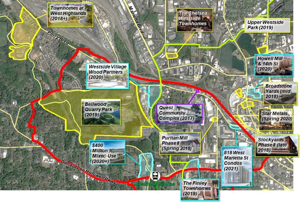
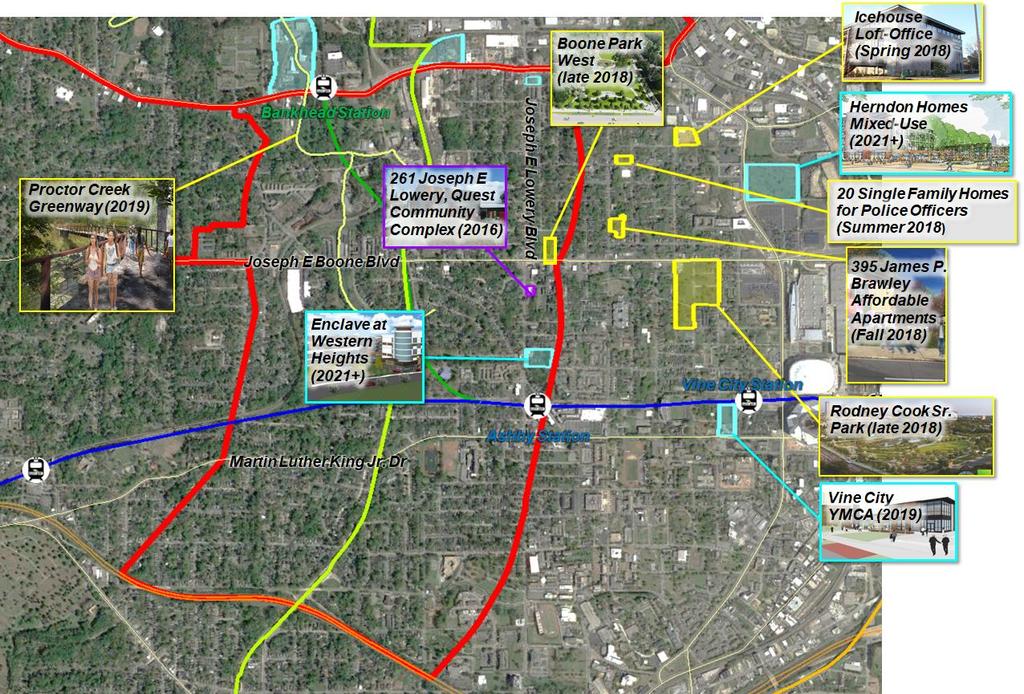
14 Development Activity in Subarea 10
15 Changes in Subarea 9 and 10 since 2010 Approx. 6,700 households with an average median household income of $30,800 Lost approx. 500 households since 2010 Relatively steady population of year-olds Slight increase in 55+ population Increase in population with a Bachelor s degree or higher Overall increase in average median household income From approx. $18,000 to $31,000 Decrease in home values From an average of $113,000 in 2010 to $100,000 in 2015 Down 13% due to slow recovery from the Great Recession Average home sale price from 2015 to 2018 is $168,000 (single family homes) Increase in population with bachelor s degree or higher + increase in income levels Decrease in number of households

16 Subarea 9: Previous Plan Land Use The previous Subarea 9 Master Plan land use goals emphasized creating compact, livable activity centers while preserving the character of existing single family neighborhoods. Goal 1: Promote compact urban development Goal 2: Create livable activity centers Goal 3: Preserve established singlefamily neighborhoods Goal 4: Promote affordable housing Goal 5: Preserve historic and cultural resources

17 Subarea 9: Previous Plan Land Use The previous Subarea 9 Master Plan highlighted specific areas for land use changes. Changes were based on existing and proposed future conditions. 1a 1b 1c 1d 1e 1f Westside Reservoir Park Bankhead Marta Station Overlook Apt. Area Marietta Blvd. Area Rockdale Rd. Area Johnson Rd. Area Grove Park Neighborhood Area 2a 2b 2c D.L. Hollowell Parkway Corridor Marietta Blvd. to Northside Drive West Lake Ave. Hollywood Rd W. Marietta St. Corridor Joseph E. Lowery Blvd. Corridor Marietta Blvd. Corridor Jefferson St. Corridor = All or partly adopted into 2016 Comp Plan
18 Subarea 9 Previous Plan Goals: Land Use Are these goals still valid? Land Use 1. Promote compact urban development 2. Create livable activity centers 3. Preserver the character of established single-family neighborhoods 4. Promote affordable housing 5. Promote the preservation of historic cultural resources
 Rail Crossings Existing Conditions: Mobility Subarea")
19 Subarea 9 Issues: (1) Limited Street Grid (2) Topography (3) Rail Crossings Existing Conditions: Mobility Subarea 3
20 Subarea 9 Bike Facilities: DL Hollowell Pkwy (part), Johnson Rd., Jefferson St. (part), Proctor Creek Trail (part) Existing Conditions: Mobility Subarea 3


21 Subarea 9 Existing Conditions: Transportation Facilities Proctor Creek Trail Hollywood Rd Bankhead MARTA Station Railroad Crossing on Lowery Blvd Signal and Pedestrian Crossing Hollywood Rd

22 Subarea 9 New Streets and Street Extensions (Street Framework Plan) Intersection Improvements Signal Coordination Traffic Calming/Access Management Streetscapes Previous Plan: Recommendations

23 Subarea 9 Previous Plan: Recommendations New Transit Routes -BeltLine Transit -DL Hollowell Pkwy BRT Extension of MARTA Green Line Streetcar Lines Bike Facilities -Bike Lanes on JE Lowery Blvd. -Brawley Dr. and Jefferson St. -Multi-use Path (Proctor Creek)
24 Subarea 9 Previous Plan Goals: Mobility Are these goals still valid? Mobility 1. Promote alternative modes of transportation 2. Promote transportation network connectivity 3. Preserve the function and character of existing roadways

25 Subarea 9: Open Space Previous Subarea 9 parks and open space goals involved making the future Westside Reservoir Park into a regional, accessible destination for all. Goal 1: Make Westside Reservoir Park a regional/local destination. Goal 2: Accommodate regional access to Westside Reservoir Park Goal 3: Ensure safe, integrated, and convenient local access to recreational opportunities


26 Aerial view of Bellwood Quarry Subarea 9 Westside Reservoir Park Layout from 2009 Master Plan Open Space
27 Subarea 9 Previous Plan Goals: Open Space Are these goals still valid? Open Space 1. Make Westside Reservoir Park an attractive regional/local destination 2. Accommodate regional access to Westside Reservoir Park 3. Ensure safe, integrated, and convenient local access to recreational opportunities
28 SUBAREA 10
29 Development Activity in Subarea 9
30 Changes in Subarea 9 and 10 since 2010 Approx. 6,700 households with an average median household income of $30,800 Lost approx. 500 households since 2010 Relatively steady population of year-olds Slight increase in 55+ population Increase in population with a Bachelor s degree or higher Overall increase in average median household income From approx. $18,000 to $31,000 Decrease in home values From an average of $113,000 in 2010 to $100,000 in 2015 Down 13% due to slow recovery from the Great Recession Average home sale price from 2015 to 2018 is $168,000 (single family homes) Increase in population with bachelor s degree or higher + increase in income levels Decrease in number of households

31 Subarea 10: Previous Plan Land Use The previous Subarea 10 Master Plan land use goals emphasized preservation of neighborhoods and promotion of development centers. GOAL 1: Preserve historic resources and encourage adaptive reuse of buildings GOAL 2: Create a safe environment for residents and businesses GOAL 3: Ensure a mix of quality housing options GOAL 5: Promote transitoriented mixed use development GOAL 7: Improve neighborhood retail services GOAL 4: Strengthen employment and commercial centers GOAL 6: Protect single-family neighborhoods and neighborhood transitions GOAL 8: Create opportunities for public art
 Proximity to the BeltLine Realistic redevelopment potential (short, mid, longterm) =")
32 Subarea 10: Previous Plan Land Use The previous Subarea 10 Master Plan highlighted three concept nodes. 1. Maddox Park 2. Luden Way 3. Boone Boulevard Concept nodes were chosen based upon: Location (within the TAD boundary) Proximity to the BeltLine Realistic redevelopment potential (short, mid, longterm) = All or partly adopted into 2016 Comp Plan
33 Subarea 10 Previous Plan Goals: Land Use Are these goals still valid? Land Use 1. Preserve historic resources + encourage adaptive reuse of historic bldgs. 2. Create a safe environment for residents and businesses 3. Ensure a mix of quality housing options 4. Strengthen employment and commercial centers 5. Promote mixed-use development within the TAD 6. Protect single-family neighborhoods 7. Improve neighborhood retail services 8. Create opportunities for public art
34 Subarea 10 Existing Conditions: Mobility Issues: Intersection Alignment and Operations Street Grid Pedestrian Crossings Rail Crossings Subarea 3
35 Subarea 10 Existing Conditions: Mobility Bike Facilities: DL Hollowell Pkwy (part) JE Boone Blvd (part) Lionel Hampton Trail Westside BeltLine Trail Subarea 3


36 Subarea 10 Existing Conditions: Transportation Facilities Lionel Hampton Trail JE Lowery Blvd & JE Boone Blvd Ashby MARTA Station Holderness Street
 Intersection Improvements Signal Coordination Traffic Calming/Access Management")
37 Subarea 10 Previous Plan: Recommendations New Streets and Street Extensions (Street Framework Plan) Intersection Improvements Signal Coordination Traffic Calming/Access Management Streetscapes

38 Subarea 10 Previous Plan: Recommendations New Transit Routes Beltline Transit DL Hollowell Pkwy BRT Extension of MARTA Green Line New infill station near Boone Blvd. Streetcar Lines Bike Facilities Bike Lanes on JE Lowery Blvd, Brawley Dr., and Boone Blvd Multi-use Path (Proctor Creek)
39 Subarea 10 Previous Plan Goals: Mobility Are these goals still valid? Mobility 1. Connect neighborhoods and link them to destinations by enhancing the street grid. 2. Coordinate multi-modal transportation improvements with new development to make transit a more viable and accessible means of travel. 3. Provide trails and pedestrian-friendly streets to improve neighborhood walkability and safety. 4. Improve transportation safety along major corridors while respecting the urban context of the area.

40 Subarea 10: Open Space Previous Subarea 10 parks and open space goals were broad-based and communityoriented. GOAL 1: Enhance opportunities for safe community gatherings GOAL 2: Provide a connected network of parks and greenspaces GOAL 3: Preserve historic features and enhance greenspaces GOAL 4: Restore degraded environmentallysensitive areas GOAL 5: Establish strong park edges


41 Subarea 10: Open Space Boone Park West will combine passive and active recreational opportunities with stormwater management practices that reduce the impacts of flooding.
42 Subarea 10 Previous Plan Goals: Open Space Are these goals still valid? Open Space 1. Enhance opportunities for safe community gathering and youth recreation. 2. Provide a connected network of well-maintained parks and green spaces. 3. Preserve historic features and enhance public access to parks and green space. 4. Reclaim and rehabilitate degraded environmentally sensitive areas. 5. Establish strong park edges.
43 Subarea Master Plan Next Steps What happens now? Your feedback matters. 1. Community Input Activity: Review information boards, development activity boards, and previous Subarea Master Plan goals and recommendations 2. Fill out the Meeting Evaluation Form and Comment Cards 3. Attend the Subarea 9 and 10 workshops on April 28th Subarea 9: 10:00 a.m. 12:00 p.m. Subarea 10: 1:00 p.m. 3:00 p.m. Location: Mount Ephraim Baptist Church (1202 W. Marietta St. NW)
44 Community Input Activity: Breakout Session Step 1. Separate into your subareas on either side of the room. Step 2. Consultant team will be available for questions. Switch topics after 20 minutes.
45 Community Input Activity: Vision Exercise Step 1. Identify ONE word that best describes your vision for the subarea. Step 2. Write the word on an index card and post on the large black boards at each station.
46 Community Input Activity: Goals Exercise Step 1. Discuss previous subarea master plans Land Use, Mobility, and Open Space goals with facilitators. Identify new goals to be considered (if any). Step 2. Prioritize the goals using red & green dots. Priority Goals 2 Goals no longer relevant 1
47 Community Input Activity: SWOT Analysis Step 1. What are the STRENGTHS and OPPORTUNITIES that the Master Plan should highlight? Write your comment on a post-it note and place on the Strengths and Opportunities sheet. Step 2. What are the WEAKNESSES or THREATS that the Master Plan should address? Write your comment on a post-it note and place on the Weaknesses or Threats sheet.

48 Questions Thank you!
Subareas 9 & 10 Master Plan Updates
 Atlanta BeltLine Subareas 9 & 10 Master Plan Updates Study Group Meeting 4 September 17, 2018 Washington Park Jamboree 1 22 miles, connecting 45 neighborhoods 22 MILES of transit 46 MILES of streetscapes
Atlanta BeltLine Subarea 3 Master Plan Update
 Atlanta BeltLine Subarea 3 Master Plan Update April 14, 2018 Workshop Meeting 1 22 miles, connecting 45 neighborhoods 22 MILES of transit 46 MILES of streetscapes and complete streets 33 MILES of urban
BeltLine Corridor Environmental Study
 BeltLine Corridor Environmental Study Citywide Conversation on Transit and Trails April 2, 2009 Agenda & Introductions Introductions Environmental Study Process Overview of the BeltLine Project BeltLine
Corridor Vision. 1Pursue Minnehaha-Hiawatha Community Works Project. Mission of Hennepin County Community Works Program
 1Pursue Minnehaha-Hiawatha Community Works Project Minnehaha-Hiawatha Community Works is a project within the Hennepin Community Works (HCW) program. The mission of the HCW program is to enhance how the
Atlanta BeltLine Corridor Environmental Study. Scoping Meeting August 2008
 Atlanta BeltLine Corridor Environmental Study Scoping Meeting August 2008 What Will We Be Discussing Today? Study Overview - How Did We Get Here? - What Is the Study About? - Who Is Involved? - Where Is
City of Fort Lauderdale UPTOWN URBAN VILLAGE. Public Workshop December 7, 2016
 Public Workshop December 7, 2016 Workshop Agenda Introductions Project Presentation o o o History Project Scope/Timeline Character of Study Area o o o o Land Use Public Realm/Pedestrian Mobility Multimodal
Atlanta BeltLine, Inc. Pathways to Urban Sustainability
 Atlanta BeltLine, Inc. Pathways to Urban Sustainability September 30, 2010 WHAT IS THE ATLANTA BELTLINE? Transit 22-mile loop Parks 1300 + new acres Trails 33 miles Jobs & Economic Development 20 areas,
BeltLine Corridor Environmental Study
 BeltLine Corridor Environmental Study Joint TAC and SAC Meeting December 8, 2008 What We Will Discuss Today Outreach and Agency Coordination Scoping Results Existing Conditions Historical and Archeological
Glenborough at Easton Land Use Master Plan
 Vision Statement Sunrise Blvd. Hazel Ave. Prairie City Rd. Gencorp Property Lincoln Regional Airport 1.0 VISION STATEMENT The identifies City of the principles, goals, policies, and standards Lincoln that
East Central Area Plan
 East Central Area Plan Steering Committee Meeting March 8 th, 2018 CHUN Tears McFarlane House Vision Statement Development Opportunities Analysis Vision Elements 1. Equitable, Affordable and Inclusive
DOMINION BOULEVARD CORRIDOR STUDY AND ECONOMIC DEVELOPMENT STRATEGIC PLAN A MODEL FOR CHESAPEAKE S FUTURE
 DOMINION BOULEVARD CORRIDOR STUDY AND ECONOMIC DEVELOPMENT STRATEGIC PLAN A MODEL FOR CHESAPEAKE S FUTURE Overview I. Draft Plan Process II. Draft Plan Overview a. Market Analysis b. Master Land Use Plan
Status Report: MD 355 Project
 Status Report: MD 355 Project OCTOBER 2006 M-NCPPC MONTGOMERY COUNTY PLANNING DEPARTMENT Summary of Community Comments, and break to the Results of the MD 355 Participation Session Brookside Gardens -
City of Tacoma Planning and Development Services
 Agenda Item E-1 City of Tacoma Planning and Development Services To: Planning Commission From: Elliott Barnett, Planning Services Division Subject: Tacoma Mall Regional Center Subarea Plan and EIS Meeting
Subarea 4 Indian Creek. Vision The combination of park networks and transportation amenities make Subarea 4 the greenest hub in the Corridor.
 indian creek 180 extends south from 101st Street to I-435. The I-435 and Metcalf intersection is one of the primary intersections in the Kansas City Metro Area. The area includes several residential neighborhoods
Tyvola & Archdale Transit Station Area Plan. June 5, 2008
 Tyvola & Archdale Transit Station Area Plan Second Public Meeting June 5, 2008 Presentation Outline 1. Purpose and Process 2. Station Area Overview 3. Plan Recommendations 4. Comments Received and Proposed
PLAN ELEMENTS WORKSHOP. April 5, 2016
 PLAN ELEMENTS WORKSHOP April 5, 2016 needs more housing. But there is no one-size fits-all solution. Every neighborhood has its own character. In some places, density is not only appropriate it is badly
Northwest Rail Corridor and US 36 BRT Development Oriented Transit Analysis 4.4 STATION AREA FINDINGS
 4.4 STATION AREA FINDINGS Each station is different, and each one requires a separate set of recommendations based on the vision for the site. This section outlines an initial TOD strategy and recommendations
124 Subarea Visions. Vision Plan. A. Nelessen Associates, INC I Visioning I Planning I Urban Design
 Subareas 124 Subarea Visions The next seven sections describe specific recommendations tailored to each subarea. Each subarea is discussed separately except for certain aspects of 95th Street and Antioch
Blue Line LRT Extension
 v e Noble Pkwy Noble Pkwy Xerxes Ave N Shingle Creek Penn Ave N Penn Ave N Fremont Ave N Lyndale Ave N S Washington Ave University Ave NE Blue Line LRT Extension LIGHT RAIL PLATFORM AND STATION DESIGN
Chapter 2: Vision, Goals and Strategies
 Chapter 2: Vision, Goals and Lake Elmo Today & Tomorrow Comprehensive Plan 2040 2 VISION, GOALS & STRATEGIES - DRAFT 4-6-2018 INTRODUCTION Comprehensive Plan Purpose Perhapse the most important objective
City of Long Beach. creating vibrant and exciting places
 City of Long Beach creating vibrant and exciting places Land Use Element Urban Design Element Overview of the two draft General Plan elements Discuss areas of change Economic goals of the plans Case study
Presentation to Town Council in association with Kubilins Transportation Group Rose & Associates Equinox Environmental
 Presentation to Town Council 03.03.09 in association with Kubilins Transportation Group Rose & Associates Equinox Environmental Vision Statement: Boone 2030 is...a friendly, vibrant, attractive community...financially,
12 th Street Connector Alignment Study VISIONING PUBLIC WORKSHOP - JUNE 25, :00PM TO 8:00PM
 12 th Street Connector Alignment Study VISIONING PUBLIC WORKSHOP - JUNE 25, 2018 6:00PM TO 8:00PM Goals for Today s Workshop Agenda: Project Introduction, Purpose, and Goals Existing Conditions Traffic
Ivywild On The Creek PRELIMINARY CREEK DISTRICT MASTER PLAN
 Ivywild On The Creek PRELIMINARY CREEK DISTRICT MASTER PLAN Introduction: Rejuvenating an extraordinary Creekside neighborhood THE CREEKSIDE DISTRICT The Ivywild On The Creek Neighborhood District Master
International Blvd. TOD Plan Public Workshop #1
 International Blvd. TOD Plan Public Workshop #1 Add photos or project images September 21 and 22, 2010 Workshop Purpose Introduce the public to the Project Review and discuss the existing conditions analysis
CITY OF UNION CITY MINUTES GENERAL PLAN ADVISORY COMMITTEE
 CITY OF UNION CITY MINUTES GENERAL PLAN ADVISORY COMMITTEE WEDNESDAY, MARCH 4, 2015, 6:30 P.M. IN THE CITY COUNCIL CONFERENCE ROOM OF CITY HALL 34009 ALVARADO-NILES BLVD., UNION CITY, CALIFORNIA Attachment
A BLUEPRINT FOR BROCKTON A CITY-WIDE COMPREHENSIVE PLAN
 A BLUEPRINT FOR BROCKTON A CITY-WIDE COMPREHENSIVE PLAN Public Meeting October 2016 1 Plan Summary and Discussion Public Meeting May 4 2017 City of Brockton Bill Carpenter, Mayor Department of Planning
Date: April 10, 2017 City Council Work Session April 24, 2017: Status Report on the Comprehensive Plan Update and Transportation Master Plan
 AGENDA REPORT To: From: By: Honorable Mayor and City Council Members Warren Hutmacher, City Manager Sharon Ebert, Director Community Development Date: April 10, 2017 Agenda: City Council Work Session April
DALY CITY VISIONING PROCESS COMMUNITY WORKSHOP 3 MAY 8, 2008
 DALY CITY VISIONING PROCESS COMMUNITY WORKSHOP 3 MAY 8, 2008 PROCESS General Plan - a statement of the community s values, vision and aspirations for now and into the future... Timeframe LONG TERM - 2030
Gold Line Bus Rapid Transit Transit Oriented Development (BRTOD) Helmo Station Area Plan
 Helmo Station Area Plan") Appendix F Gold Line Bus Rapid Transit Transit Oriented Development (BRTOD) Helmo Station Area Plan Introduction and Purpose of the Plan The Gold Line Bus Rapid Transit facility is an eleven-mile dedicated
Appendix F Gold Line Bus Rapid Transit Transit Oriented Development (BRTOD) Helmo Station Area Plan Introduction and Purpose of the Plan The Gold Line Bus Rapid Transit facility is an eleven-mile dedicated
INDEPENDENCE BOULEVARD AREA PLAN. June 24, 2008
 INDEPENDENCE BOULEVARD AREA PLAN Public Meeting #1 June 24, 2008 Tonight s Agenda Introduction Welcome and Ground Rules Overview Presentation Purpose of the Plan What Brings Us Here? A Tour of the Corridor
BROOKHILL NEIGHBORHOOD MODEL ZONING MAP AMENDMENT PREFACE TO APPLICATION
 BROOKHILL NEIGHBORHOOD MODEL ZONING MAP AMENDMENT PREFACE TO APPLICATION June 15, 2015 Revised: August 1, 2016 I. VISION Brookhill is a proposed community based upon the principles of Albemarle County
WELCOME and introduction
 1 WELCOME and introduction Mobility Hub Locations within Burlington STUDY OVERVIEW STUDY OBJECTIVES The City of Burlington is developing four Area Specific Plans, one for each of Burlington s Mobility
South Davis County COMMUNITY SPOTLIGHT
 South Davis County COMMUNITY SPOTLIGHT Davis/SLC Community Connector Bus Rapid Transit line connecting SLC & Davis County RTP Phase 1 Project Generate 3,100 average weekday riders Relieve congestion on
INDEPENDENCE BOULEVARD AREA PLAN. Economic Development Committee Overview May 25, 2010
 INDEPENDENCE BOULEVARD AREA PLAN Economic Development Committee Overview May 25, 2010 Presentation Outline Plan Purpose and Development Process Draft Plan Policies and Implementation Strategies Request
Somers Point Master Plan
 Somers Point Master Plan Progress Report and Public Meeting August 20, 2014 Master Plan Reexamination Municipal Land Use Law require that all municipalities reexamine their master plan every ten years.
New Partners for Smart Growth Conference February 5, 2010
 Dan Stroh, Planning Director City of Bellevue Planning and Community Development Bellevue, WA New Partners for Smart Growth Conference February 5, 2010 Summary of Project Long-range plan update for Bel-Red
Sustainability, Health, Safety, Recreation & Open Space Working Group August 3, 2017
 Sustainability, Health, Safety, Recreation & Open Space Working Group August 3, 2017 DOWNTOWN OAKLAND SPECIFIC PLAN WELCOME Sustainability, Health, Safety, Recreation & Open Space Working Group Social
Visioning Statement and Guiding Principles
 Visioning Statement and Guiding Principles Planning for the Future The General Plan The General Plan represents Woodland's shared vision of the future and defines a path to lead the community toward its
Wasatch CHOICE for 2040
 Wasatch CHOICE for 2040 Economic Opportunities We Can Choose a Better Future We enjoy an unparalleled quality of life along the Wasatch Front. People from all over the world are drawn to our stunning scenery,
DRAFT PLAN PRESENTATION
 DRAFT PLAN PRESENTATION 1.23.2018 AGENDA Process Project Schedule Results from Visioning Workshop Draft Plan Highlights Concept Plans Feedback Next Steps PROJECT SCHEDULE KICK-OFF WORKSHOP August 29 th
BROOKLYN PARK / 85TH AVE LRT STATION CDI DEVELOPMENT GUIDELINES DRAFT
 August 2018 Page intentionally left blank The Brooklyn Park Library adjacent to the 85th Ave LRT Station Area. OVERVIEW The Blue Line LRT Extension / Bottineau corridor offers a unique opportunity to leverage
The Atlanta BeltLine. Quarterly Briefing March @atlantabeltline. Reynoldstown Senior Affordable Housing
 The Atlanta BeltLine Quarterly Briefing March 30, 2017 @atlantabeltline @atlantabeltline @atlantabeltline Reynoldstown Senior Affordable Housing Framework for a multi-use and transit corridor in the heart
Moody Centre Station TOD Area Today
 Moody Centre Station TOD Area Today WHAT IS a transit-oriented Murray Street development area? A Transit-Oriented Development (TOD) Area is a dense, walkable residential and commercial area built to support
RECOMMENDED GOALS, CONCEPTS, GUIDELINES PUBLIC PARTICIPATION PROGRAM
 2015 RECOMMENDED GOALS, CONCEPTS, GUIDELINES PUBLIC PARTICIPATION PROGRAM THE MARYLAND-NATIONAL CAPITAL PARK AND PLANNING COMMISSION PRINCE GEORGE S COUNTY PLANNING DEPARTMENT SEPTEMBER 24, 2015 INTRODUCTION
Implementation Guide Comprehensive Plan City of Allen
 Implementation Guide 2030 Comprehensive Plan City of Allen DRAFT 2015 Implementation Guide Allen 2030 Comprehensive Plan INTRODUCTION The Comprehensive Plan serves as a guide for the growth and development
The Five Components of the McLoughlin Area Plan
 The Five Components of the McLoughlin Area Plan This documents contains the complete language of the five components of the McLoughlin Area Plan: The Vision Statement The Values The Guiding Principles
Public Open House #1
 Public Open House #1 TONIGHT S AGENDA Welcome Project Overview The Big Picture The Station Area The Analysis Thoughts about Future Change Breakout Group Discussions Summation / Next Steps Project Overview
Transit Implementation Strategy Westside Study Group Meeting
 Westside Study Group Meeting February 27, 2012 The Portland Streetcar Passing Through a Park Near Portland State University Westside Study Group Meeting February 27, 2012 1. TIA Update 2. TIS Process To-Date
1.0 VISION STATEMENT. December 6, PRINCIPLES
 Vision Statement Lincoln Regional Airport 1.0 VISION STATEMENT 1.1 City LOCATION of AND OVERVIEW The Easton Lincoln Place Land Use Master Plan identifies the principles, goals, policies, and standards
Welcome to the Oakridge Centre Open House
 Welcome to the Oakridge Centre Open House Why is the City hosting this event? This open house is to inform you of a rezoning application submitted to the City of Vancouver to amend the existing CD-1 (Comprehensive
THE 355/270 CORRIDOR:
 THE 355/270 CORRIDOR: Strategic Ideas for Sustaining a Livable Work Place Project Summary ACCESS LIFE DESIGN HEALTH WORK Montgomery County Planning Department The Maryland-National Capital Park and Planning
Citizen Comment Staff Response Staff Recommended Revision Planning Committee
 Citizen Comment Staff Response Staff Recommended Revision Planning Committee Area No. 1: Owner desires retail land uses. Area No. 1a: Owner of two small parcels adjacent to Area No. 1 desires retail land
Introduction. Chapter 1. Purpose of the Comprehensive Plan Plan Organization Planning Process & Community Input 1-1
 Chapter 1 Introduction Lakewood 2025: Moving Forward Together Purpose of the Comprehensive Plan Plan Organization Planning Process & Community Input 1-1 Purpose of the Comprehensive Plan The Comprehensive
Welcome. Comprehensive Plan & Transportation Plan Open House November 7, 2012
 Welcome Comprehensive Plan & Transportation Plan Open House November 7, 2012 Agenda Proposed future land use plan Comprehensive Plan strategies Traffic forecasts Future traffic operations Possible future
Blueprint Denver Task Force Meeting #
 Blueprint Denver Task Force Meeting #1 6.23.16 1. Welcome and Introductions Your name and affiliation Name 1 thing you love about Denver Name 1 thing you d change about Denver All in 30 seconds! Ready,
The University District envisions, in its neighborhood
 Envisioning the University District Link Light Rail in Seattle s neighborhoods CIY OF SEALE CONCEP-LEVEL SAION AREA PLANNING RECOMMENDAION RESOLUION # 30165 EXHIBI L Vision 08.2000 he University District
Ten Mile Creek Planning Area
 PLANNING AREA POLICIES TEN MILE CREEK Ten Mile Creek Planning Area Location and Context The Ten Mile Creek Planning Area ( Ten Mile Creek area ) is located south of the current Boise AOCI, generally south
1 October Dear Citizens of Charlotte and Mecklenburg County,
 1 October 2011 Dear Citizens of Charlotte and Mecklenburg County, As co-chairs of the Center City 2020 Vision Plan Steering Committee, we are proud to present the Center City 2020 Vision Plan, which sets
Silverdale Regional Center
 Silverdale Regional Center Vision for Silverdale Regional Center The Silverdale Regional Center Plan (Plan) will guide the evolution of the Silverdale Regional Center from a collection of strip malls and
Streets, Connectivity & Built Environment Working Group August 2, 2017
 Streets, Connectivity & Built Environment Working Group August 2, 2017 DOWNTOWN OAKLAND SPECIFIC PLAN WELCOME Streets, Connectivity & Built Environment Working Group Social Equity Meeting August 2, 2017
Old Town Neighborhoods Plan. Choices Event Wednesday, December 9, 2015
 Old Town Neighborhoods Plan Choices Event Wednesday, December 9, 2015 Agenda 6:00 6:10 p.m. Welcome + Sign In 6:10 6:30 p.m. Presentation 6:30 8:00 p.m. Workshop + Open House Seeking your input on: Neighborhood
Aldershot GO Draft Mobility Hub Concepts. East Plains United Church September 13, :30 8:30 pm
 Aldershot GO Draft Mobility Hub Concepts East Plains United Church September 13, 2017 6:30 8:30 pm Today s Agenda 6:30pm: 6:35pm: 7:10pm: 8:10pm: 8:25pm: Opening Remarks Rosa Bustamante, Manager Mobility
Equitable Growth Through TOD Planning
 Equitable Growth Through TOD Planning Community Meeting # 2 November 2017 Goals Objectives Extend investment from downtown Connect neighborhoods physically and economically Enhance places based on local
JANUARY 19, 2011 CENTRAL AVENUE-METRO BLUE LINE TRANSIT-ORIENTED DEVELOPMENT IMPLEMENTATION PROJECT COMMUNITY FORUM
 CENTRAL AVENUE-METRO BLUE LINE TRANSIT-ORIENTED DEVELOPMENT IMPLEMENTATION PROJECT COMMUNITY FORUM JANUARY 19, 2011 THE MARYLAND-NATIONAL CAPITAL PARK AND PLANNING COMMISSION PRINCE GEORGE S COUNTY PLANNING
CITY OF WESTERVILLE, PLANNING AND DEVELOPMENT. BASSEM BITAR / (614) /
 /") Staff Report Meeting Date: September 21, 2016 Case #: PC 2016-17 WESTERVILLE PLANNING COMMISSION Request: Applicant: Staff Liaison: RECOMMEND TO CITY COUNCIL FOR ITS FURTHER ACTION THE IMAGINE WESTERVILLE
Staff Report Meeting Date: September 21, 2016 Case #: PC 2016-17 WESTERVILLE PLANNING COMMISSION Request: Applicant: Staff Liaison: RECOMMEND TO CITY COUNCIL FOR ITS FURTHER ACTION THE IMAGINE WESTERVILLE
Chapter 1: Introduction
 Chapter 1: Introduction The Penn Avenue Community Works Corridor Vision and Implementation Framework presents an integrated communitybased vision and a coordinated, long-term implementation framework for
ELK GROVE GENERAL PLAN VISION
 2-1 CHAPTER 2: 2-2 CREATING OUR The Community Vision for Elk Grove, expressed through a Vision Statement and a series of Supporting Principles, is a declaration of the kind of community that Elk Grove
Secrest Short Cut and Monroe Expressway Small Area Plan AUGUST 29, 2018
 Secrest Short Cut and Monroe Expressway Small Area Plan AUGUST 29, 2018 Background and Process Monroe Expressway will be open by the end of 2018 Union County and Indian Trail identified a need to revisit
INDEPENDENCE BOULEVARD AREA PLAN. Economic Development Committee Overview March 10, 2011
 INDEPENDENCE BOULEVARD AREA PLAN Economic Development Committee Overview March 10, 2011 Presentation Outline Purpose: To provide an overview of the Independence Boulevard Area Plan and to request a recommendation
The transportation system in a community is an
 7 TRANSPORTATION The transportation system in a community is an important factor contributing to the quality of life of the residents. Without a sound transportation system to bring both goods and patrons
GO Station Mobility Hubs: Draft Precinct Plans. Committee of the Whole July 12, 2018
 GO Station Mobility Hubs: Draft Precinct Plans Committee of the Whole July 12, 2018 Purpose of this Workshop Present Draft Precinct Plans for the 3 GO Station Mobility Hubs Continue the conversations that
REZONING GUIDE. Zone Map Amendment (Rezoning) - Application. Rezoning Application Page 1 of 3. Return completed form to
 - Application. Rezoning Application Page 1 of 3. Return completed form to") Zone Map Amendment (Rezoning) - Application COMMUNITY PLANNING & DEVELOPMENT REZONING GUIDE Rezoning Application Page 1 of 3 PROPERTY OWNER INFORMATION* CHECK IF POINT OF CONTACT FOR APPLICATION Property
Zone Map Amendment (Rezoning) - Application COMMUNITY PLANNING & DEVELOPMENT REZONING GUIDE Rezoning Application Page 1 of 3 PROPERTY OWNER INFORMATION* CHECK IF POINT OF CONTACT FOR APPLICATION Property
March 14, :30 p.m.-city Hall
 March 14, 2012 6:30 p.m.-city Hall Board of Mayor and Commissioners (BOMC) Citizens, Property and Business Owners Planning and Zoning Board (P&Z) Downtown Development Authority (DDA) Architectural Review
Cobb County Design Guidelines Mableton Parkway & Veterans Memorial Highway Community Design Workshop January 12, 2017
 Community Design Workshop January 12, 2017 Agenda Opening Remarks / Introductions Scope of Work Existing Conditions Key Issues / Opportunities VPS Summary Draft Vision & Goal Statement Implementation Concepts
In surveys, Dallas residents say what they want to change most
 NEIGHBORHOODS ELEMENT In surveys, Dallas residents say what they want to change most in the city is its appearance they want it to look beautiful, with trees and pedestrian-friendly neighborhoods. The
Community Visioning Workshop Prep
 Community Visioning Workshop Prep Visioning Workshop 73 Visioning Workshop: Public Events 1 2 3 4 74 Visioning Workshop: draft Schedule 75 Visioning Workshop: draft Schedule working to schedule stakeholder
South Central Connecticut Region Plan of Conservation & Development 2018 Update. Municipal Planners
 South Central Connecticut Region Plan of Conservation & Development 2018 Update Municipal Planners July 28th, 2017 1 Introductions 2 Purpose of Today s Meeting Supplement data analysis with qualitative
Comprehensive Plan Advisory Panel Meeting #3
 Comprehensive Plan Advisory Panel Meeting #3 November 7, 2016 Agenda 1. September 19 th Meeting Notes 2. Summary of Focus Areas Charrette 3. Heart of the City Focus Area a. HOC2/Station Areas Concept &
Design Fort Ord. welcome why we are here what happened this week design guidelines: ideas so far 2/12/2015. Regional Urban Design Guidelines (RUDG)
") Design Fort Ord Regional Urban Design Guidelines (RUDG) Welcome Back! Strategic Economics Alta Planning + Design National Charrette Institute Helix Environmental Planning Jeff Speck & Peter Katz Civitas
Design Fort Ord Regional Urban Design Guidelines (RUDG) Welcome Back! Strategic Economics Alta Planning + Design National Charrette Institute Helix Environmental Planning Jeff Speck & Peter Katz Civitas
Murphy Crossing Site Redevelopment Community Engagement Meeting September 19, 2016
 Murphy Crossing Site Redevelopment Community Engagement Meeting September 19, 2016 SUMMARY 1 EXECUTIVE SUMMARY STATEMENT OF PURPOSE ABI has conducted a detailed study of 1. Market potential 2. Building
Community Open House March 26 th, 2018
 Community Open House March 26 th, 2018 Open House Agenda 1. Overview of Planning Process What we heard 2. Future Land Use Policy 3. Priority Growth Areas 4. Plan Elements Making it happen What is a Comprehensive
Lynn Housing Authority and Neighborhood Development. Washington Street Gateway District Plan A p r i l
 Lynn Housing Authority and Neighborhood Development Washington Street Gateway District Plan A p r i l 2 0 0 8 rendering of sagamore hill from lynnway pedestrian overpass table of contents project area
Complete Neighbourhood Guidelines Review Tool
 Complete Neighbourhood Guidelines Review Tool Prepared By: City of Regina Planning Department October 2014 Page 1 of 14 Community Development Review Checklist for Secondary Plans and Concept Plans The
TREASURE COAST REGIONAL PLANNING COUNCIL M E M O R A N D U M. To: Council Members AGENDA ITEM 5H
 TREASURE COAST REGIONAL PLANNING COUNCIL M E M O R A N D U M To: Council Members AGENDA ITEM 5H From: Date: Subject: Staff October 17, 2008 Council Meeting Local Government Comprehensive Plan Review Draft
East Central Area Plan
 East Central Area Plan Steering Committee Meeting January 10 th, 2019 Tears-McFarlane House Community Room East Central Area Plan Steering Committee Meeting January 10 th, 2019 CHUN Tears-McFarlane House
UPDATE ON THE INDEPENDENCE BOULEVARD AREA PLAN. Citizen Advisory Group Meeting March 3, 2011
 UPDATE ON THE INDEPENDENCE BOULEVARD AREA PLAN Citizen Advisory Group Meeting March 3, 2011 Purpose: Why are we here? To provide an update on the Independence Boulevard Area Plan 1. Overview of the ULI
Gratigny Parkway East Extension Project Development & Environment (PD&E) Study
 Study") Gratigny Parkway East Extension Project Development & Environment (PD&E) Study Session 4: Presentation of Charrette Results December 8, 2010 MDX Work Program #: 92407 ETDM#: 11500 Project Location & Description
Gratigny Parkway East Extension Project Development & Environment (PD&E) Study Session 4: Presentation of Charrette Results December 8, 2010 MDX Work Program #: 92407 ETDM#: 11500 Project Location & Description
The Mobile Peninsula Corridor Master Plan Dauphin Island Parkway I 10 to Dog River
 The Mobile Peninsula Corridor Master Plan Dauphin Island Parkway I 10 to Dog River Welcome and Introductions Alice Keel Co Founder Prayer Rev. Jim Langston Fulton Road Baptist Church Comments Stewart Hanley,
Rio/29 Small Area Plan. Design Plan & Implementation Framework Open House - January 25, 2018
 Rio/29 Small Area Plan Design Plan & Implementation Framework Open House - January 25, 2018 MEETING PURPOSE PRESENTATION 1. Orient to the updated design plans 2. Introduce implementing options 3. Explain
Plano Tomorrow Vision and Policies
 Plano Tomorrow Vision and Policies PLANO TOMORROW PILLARS The Built Environment The Social Environment The Natural Environment The Economic Environment Land Use and Urban Design Transportation Housing
April 21, 2007 CCRP Workshop Summary
 April 21, 2007 CCRP Workshop Summary Group 1 1. Reuse around BART with a lot of housing and jobs 2. Greenway around creek 3. Transit and auto connection all through the site from Kirker Pass to Port Chicago
S A C R A M E N T O C O U N T Y JACKSON HIGHWAY & GRANT LINE EAST VISIONING STUDY
 JACKSON HIGHWAY & GRANT LINE EAST S A C R A M E N T O C O U N T Y P L A N N I N G D E P A R T M E N T SUMMARY AND WORKBOOK November 19, 2008 History of the Visioning Study Sacramento County has two growth
PLACEMAKING & MOBILITY WORKSHOP. January 27, 2016
 PLACEMAKING & MOBILITY WORKSHOP January 27, 2016 Boston needs more housing. But there is no one-size fitsall solution. Every neighborhood has its own character. In some places, density is not only appropriate
SW Ecodistrict A VISION PLAN FOR A MORE SUSTAINABLE FUTURE June 25, 2013
 Urban Land Institute The Past, Present and Future of Sustainable Urbanism in Southwest DC SW Ecodistrict A VISION PLAN FOR A MORE SUSTAINABLE FUTURE June 25, 2013 Study Area The National Mall DOE FAA FAA
Official Plan Review
 Official Plan Review Summary Report - The Built Environment August 2014 Part 1: Introduction Planning for a healthy, prosperous and sustainable community is an important goal for our municipality. From
Independence Boulevard Area Plan Planning Committee Public Comment May 18, 2010
 Independence Boulevard Area Plan Planning Committee Public Comment May 18, 2010 Presentation Outline Focus on Key Recommendations within Draft Plan Plan Purpose and Development Process Draft Plan Policies
Summary Community Workshop #1 Fruitvale San Antonio Senior Center Monday, March 23, :00-9:00 p.m.
 Summary Community Workshop #1 Fruitvale San Antonio Senior Center Monday, March 23, 2009 7:00-9:00 p.m. Workshop Format and Process The City of Oakland is preparing a Specific Plan that will help define
Key Concepts of the General Plan
 Key Concepts of the General Plan General Plan Purpose Vision for City s future Standards for City Services Land Use Plan General Plan Purpose San Jose is creating its Blueprint for the Future to become
Tyvola & Archdale Transit Station Area Plan. May 15, 2008
 Tyvola & Archdale Transit Station Area Plan First Public Meeting May 15, 2008 Presentation Outline 1. Purpose and Process 2. Station Area Overview 3. Plan Recommendations Vision Land Use Transportation