MOREE SOLAR POWER STATION
|
|
|
- Beryl McCormick
- 6 years ago
- Views:
Transcription


1 MOREE SOLAR POWER STATION LANDSCAPE & VISUAL IMPACT ASSESSMENT Prepared for: December 2010 Prepared by: GREEN BEAN DESIGN l a n d s c a p e a r c h I t e c t s GREEN BEAN DESIGN l a n d s c a p e a r c h I t e c t s PO Box 3178 Austral NSW
2 Author: Andrew Homewood, Registered Landscape Architect BSc (Dual Hons), Dip.LM, Dip.Hort, AILA Date: December 2010 Reference: V Status: V3 Final GREEN BEAN DESIGN l a n d s c a p e a r c h I t e c t s GREEN BEAN DESIGN l a n d s c a p e a r c h I t e c t s PO Box 3178 Austral NSW
3 Contents Section 1 Introduction and Methodology 1.1 Introduction 1.2 Desktop study 1.3 Fieldwork 1.4 Assessment of visual impact Section 2 The Project 2.1 Project Location 2.2 Project Description Section 3 View Shed and Visibility 3.1 Introduction 3.2 Solar Power Station View Shed kV Transmission Line View Shed 3.4 Visibility Section 4 Local Environmental Factors 4.1 Climatic and Atmospheric Conditions 4.2 Topography and Drainage 4.3 Vegetation Section 5 Panorama Photographs 5.1 Panorama Photographs Section 6 Landscape Character Areas and Sensitivity Assessment 6.1 Landscape Character Areas 6.2 Landscape Sensitivity Assessment 6.3 LCA 1 Rural Agricultural Areas 6.4 LCA 2 Rural Residential 6.5 LCA 3 Agricultural & Industrial 6.6 LCA 4 Transport and Transmission Line Corridors Section 7 Visual Assessment 7.1 Introduction 7.2 Visibility Matrix 7.3 Visual Impact Assessment Section 8 Photomontage 8.1 Photomontage Section 9 Reflectivity, Sunglint and Glare 9.1 Introduction 9.2 Sunglint 9.3 Glare Section 10 Night time lighting 10.1 Introduction 10.2 Existing light sources 10.3 Potential Visual Impact GREEN BEAN DESIGN l a n d s c a p e a r c h I t e c t s PO Box 3178 Austral NSW
4 Section 11 Pre construction and Construction 11.1 Potential Visual Impacts Section 12 Cumulative Impact Assessment 12.1 Cumulative Impact Assessment Section 13 Mitigation 13.1 Mitigation 13.2 Avoidance 13.3 Reduction 13.4 Offset Section 14 Conclusion 14.1 Conclusion Figures Figure 1 Figure 2 Figure 3 Figure 4 Figure 5 Figure 6 Location Plan Solar Power Station Detail Layouts Photo Voltaic (PV) Panel Details View Shed View Distance Panorama Photograph Locations Figure 7 Panorama Photo Sheet 1 (Photo Locations P1 to P4) Figure 8 Panorama Photo Sheet 2 (Photo Locations P5 to P8) Figure 9 Panorama Photo Sheet 3 (Photo Locations P9 to P12) Figure 10 Panorama Photo Sheet 4 (Photo Locations P13 to P16) Figure 11 Panorama Photo Sheet 5 (Photo Locations P17 to P20) Figure 12 View Locations Figure 13 Photomontage 1 Figure 14 Photomontage 2 Figure 15 Existing Development GREEN BEAN DESIGN l a n d s c a p e a r c h I t e c t s PO Box 3178 Austral NSW
5 Introduction and Methodology SECTION Introduction This Landscape and Visual Impact Assessment (LVIA) for the BP Solar Power Station (the Project) has been prepared by Green Bean Design Landscape Architects (GBDLA) on behalf of BP Solar Pty Ltd and Walsh Consulting Pty Ltd for a photovoltaic (PV) solar farm and associated works located south of Moree in far northern New South Wales. This LVIA addresses one of the key requirements for the Project Environmental Assessment (EA) to be submitted and assessed under Part 3A of the Environmental Planning & Assessment Act 1979 (EP&A Act). The LVIA methodology has been applied to a number of similar assessments prepared by GBDLA, including transmission lines, electrical infrastructure and power generation projects. The LVIA methodology adopts a number of principles outlined in the Guidelines for Landscape and Visual Impact Assessment, The Landscape Institute and Institute of Environmental Management and Assessment 2002, as well as drawing on current guidelines developed by State and Federal Government for the landscape and visual assessment of renewable energy projects. The LVIA involved an evaluation of landscape character surrounding, the Project site together with an assessment of visual impact that may result from the construction and operation of the Project. GBDLA is not aware of any areas of landscape within the immediate Project viewshed that may be subject to any Local, State or Federal statutory designations for high landscape values or scenic quality and/or scenic protection. A primary objective of the LVIA was to determine the likely visual impact of the Project on people living and working in, or travelling through surrounding areas. The LVIA methodology comprised the following key activities: Desktop study addressing visual character of the Project site and immediate surrounding area; Identification of the Project view catchment; Site inspection and fieldwork; Assessment and determination of Visual Absorption Capability; Preparation of photomontages; Assessment of visual impact from publicly accessible view points and residential dwellings; and Discussion of mitigation measures and how they may reduce levels of visual impact. GREEN BEAN DESIGN l a n d s c a p e a r c h I t e c t s PO Box 3178 Austral NSW
6 1.2 Desktop study A desktop study was carried out to identify the potential view catchment of the Project. This was undertaken by reference to 1:25,000 topographic maps as well as aerial photographs of the alignment and immediate surrounding areas. The desktop study identified the visual character of the surrounding landscape including features such as the site context, landform and elevation. The desktop study also identified and mapped a number of potential view locations from which the Project may be visible. Although it is not feasible to assess each and every view that may exist toward the Project, the desk top study did seek to identify and assess key view locations, including views from areas close to residences and transport corridors. 1.3 Fieldwork The fieldwork involved: A detailed site inspection to determine the potential extent of visibility of the Project and associated infrastructure; Determination of the various view locations from which the Project and associated infrastructure could potentially be visible from; and Preparation of a photographic and written record. 1.4 Assessment of visual impact The visibility of the Project would primarily result from the combination of two factors: the extent to which the Project would be visible from surrounding areas; and the degree of visual contrast between the Project and the surrounding landscape that would be visible from key view locations. The overall visual impact is generally determined by a combination of factors including: the category and type of situation from which people may view the components of the Project (e.g. resident or motorist); the potential number of people with a view toward components of the Project from any one view location; the distance between a person and components of the Project; and the duration of time that a person may view components of the Project. An underlying rationale for this LVIA is that if people are not recorded at a particular location, or if views toward the Project are screened, then there is likely to be a nil visual impact at that location. GREEN BEAN DESIGN l a n d s c a p e a r c h I t e c t s PO Box 3178 Austral NSW
7 It should be noted that all residential dwellings identified through the desk top assessment of aerial photographs and mapping were assessed during the field work study; however the LVIA field work was undertaken from publicly accessible locations only. GREEN BEAN DESIGN l a n d s c a p e a r c h I t e c t s PO Box 3178 Austral NSW
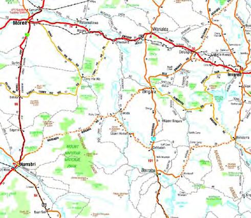
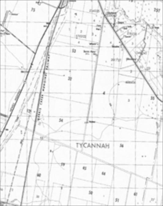
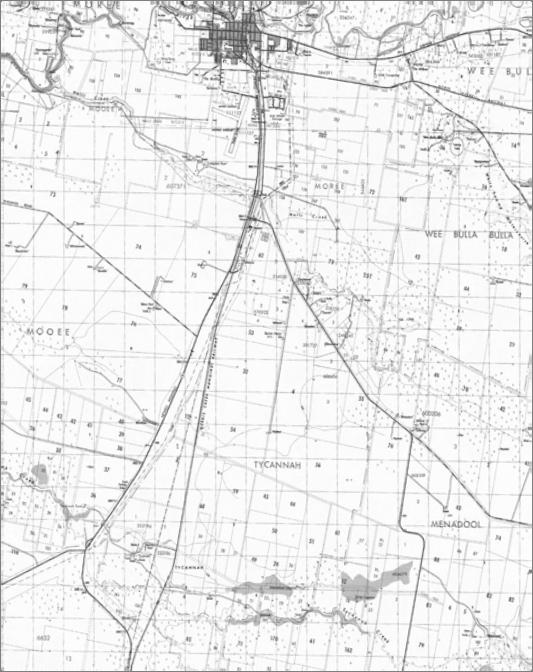
8 The Project SECTION Project Location The Project would be located in far northern New South Wales approximately 8km south of Moree, and 100km south the New South Wales and Queensland border. Moree is located at the junction of the Newell and Gwydir Highways and attracts a number of tourists who visit the Moree Hot Artesian Pool Complex established in The Project would extend across two landholdings covering an area of approximately 1129ha, administered by the Moree Plains Shire Council. The Moree Plains Shire covers approximately 17,900km 2 of highly productive primary agricultural land including cultivation of wheat, pulses, cotton and livestock production. The Project area would therefore represent a very small portion of Council s administered area. The Project is surrounded by a range of landuse types including rural agricultural or industrial installations and described as follows: Landuse to the north of the Project includes Council s Waste Management Facility, the Saleyards and the Duvanant s Cotton Gin. Landuse to the east of the Project includes rural residential subdivision areas and cultivated agricultural land. Landuse to the south of the Project includes open and extensive tracts of agricultural land. Landuse to the west of the Project includes the Northern Tablelands Explorer railway line, the Newell Highway road corridor and easements for 66kv and 132kV transmission lines. The Project would also include approximately a 10km length of 132kV transmission line from the Project site to the Moree Zone substation. The final alignment for the transmission line would be subject to detailed design; however, for the purpose of the LVIA the route is described as follows: From the Moree Zone Substation the transmission would travel east toward Tycannah Street and then south along Industrial Drive. The transmission line would then continue along Tycannah Street toward the Burrington Road and then follow Burrington Road south east to Barton Plains Road. The transmission line would then travel south along Barton Plains Road to the Project site. There are no known large publically accessible areas including National Parks, State Conservation Areas or Reserves from which views toward the Project would create any visual impact. The general location of the Project is illustrated in Figure 1. GREEN BEAN DESIGN l a n d s c a p e a r c h I t e c t s PO Box 3178 Austral NSW

9
10 2.2 Project Description (Solar Power Station and 132kV transmission line) The key visual components of the solar power station would comprise: Flat crystalline photovoltaic (PV) modules; Electrical inverters; Transformers; 22/132kV Substation (on site); 2m high perimeter security fence; Amenities building, workshop and small car park; and Low level lighting around amenities building, workshop, car park and substation. The key visual components of the 132kV transmission line would comprise: Single tapered concrete poles spaced approximately 200m to 250m apart and up to 18.8m tall; Aluminium alloy 132kV conductors; and An aerial earth wire and communications link. The 132kV transmission line would be approximately 10km in length between the Project Substation and Moree Zone Substation, with approximately 60 poles incorporating support and tension structures for angle locations. The transmission line would be constructed within a 45m wide easement located within Council road reservations or similar along the length of the route. The majority of the proposed transmission line would be accessible for maintenance purposes from existing roads and tracks. The proposed layout for the Project and general arrangement and details of the PV panels are illustrated in Figures 2 and 3. GREEN BEAN DESIGN l a n d s c a p e a r c h I t e c t s PO Box 3178 Austral NSW
11
12
13 Table 2 Viewshed Descriptors Distance from Project >5km Potential Viewshed Descriptors The constructed elements within the Project would be indistinct from the surrounding landscape with a likely overall Nil or Very Low level visibility. 2-5km The constructed elements within the Project may be visible in the landscape but tend to become less noticeable with increasing distance. Potentially noticeable but unlikely to be dominant within viewshed and potentially resulting in Very Low to Low level visibility. 500m-2km The constructed elements within the Project would be visible within the landscape from some surrounding areas; however, the Project would be less noticeable with increasing distance. Potential for Low to Moderate visibility depending on the category of viewer and their location m The constructed elements within the Project would tend to be visible from the surrounding landscape. The majority of Project structures are likely to be recognisable within viewshed with a potential High level of visibility depending on the category of viewer, their location, and sensitivity. The relationship between the Project viewshed and potential view locations is illustrated in Figure 4, and the relationship between the Project visibility and view location distance is illustrated in Figure kV Transmission Line Viewshed The view catchment for the transmission line has been determined as a one kilometre offset from either side of the transmission line. Beyond one kilometre views toward the Project may have a greater tendency to be screened by undulating landform or the presence of vegetation for portions of the west and east alignments. It is also considered that whilst some Project components would be noticeable from areas beyond one kilometre, they are unlikely to appear as a dominant visual element within the landscape at this distance. The view catchment is a generalised assessment, where views toward the Project could, in some situations, be blocked by buildings, vegetation or local landform features at specific points within the one kilometre offset, and similarly glimpses of the Project would be available from isolated positions outside the view catchment area. The photograph in Plate 1 illustrates an existing 132kV transmission line south of the Moree Zone substation and demonstrates the influence of distance on visibility. GREEN BEAN DESIGN l a n d s c a p e a r c h I t e c t s PO Box 3178 Austral NSW
14 View Shed and Visibility SECTION Introduction A key component of the LVIA is defined by the description, assessment and determination of the viewshed and visibility associated with the Project. It is a combination of these issues that sets out the framework for determining the significance and magnitude of potential visual impact of the Project on view locations within the landscape. In order to clarify and explain this component of the LVIA, the relationship between viewshed and visibility is outlined and defined in Table 1. Table 1 Definitions Viewshed Definition An area of land surrounding and beyond the Project area which may be potentially affected by the Project. Relationship Identifies the majority of the LVIA study area that incorporates view locations that may be subject to a degree of visual impact. Visibility A relative determination at which various locations elements of the Project can be clearly discerned and described. Describes the likely extent and relative scale of the Projects constructed elements may be visible from any view location. An overview of viewshed and visibility is discussed in the following sections. 3.2 Solar Power Station Viewshed The Project viewshed has been illustrated as a series of concentric bands (in 1km widths) extending across the landscape up to 5km from the Project. The distance of the viewshed can vary between a range of power generation projects, and may be influenced and informed by a number of criteria including the height of structures together with the nature, location and height of landform that may limit visibility. It is important to note that the Project may be visible from some areas of the landscape beyond the nominated viewshed; however, within the general parameters of normal human vision, the solar panels at a maximum height of approximately 3.3m would occupy a relatively small proportion of a person s field of view from distances in excess of 5km. The viewshed is used as a framework and guide for visibility assessment, as the degree of visual impacts would tend to be gradated with distance although there are unlikely to be any distinct or abrupt noticeable changes between the nominated distance bands. For the purpose of the LVIA, the viewshed assumptions for the Project are outlined in Table 2. GREEN BEAN DESIGN l a n d s c a p e a r c h I t e c t s PO Box 3178 Austral NSW
15
16


17 132kV supporting structure at around 1km from photo location. 132kV supporting structure at around 100m from photo location. Plate 1. Existing 132kV single pole transmission line north of the Moree Substation 3.4 Visibility The visibility of the Project within the viewshed can result from a number of factors: Distance With an increase in distance the proportion of a person s horizontal and vertical view cone occupied by a visible structure, or group of structures, would decline. As the view distance increases so do the atmospheric effects resulting from dust particles and moisture in the atmosphere, which makes the Projects structures appear to be grey thus potentially reducing the contrast between the structures and the background against which they are viewed. Whilst the distance between a view location and Project is a primary factor to consider when determining potential visibility, there are other issues which may also affect the degree of visibility. Movement The visibility of the Project would vary between the categories of static and dynamic view locations. In the case of static views the relationship between the Project and the landscape would not tend to vary greatly. The extent of vision may be relatively wide as a person would tend to scan views back and forth across the landscape. In contrast views from a moving vehicle are dynamic as the visual relationship between the Project is constantly changing as well as the visual relationship between the Project elements and the landscape GREEN BEAN DESIGN l a n d s c a p e a r c h I t e c t s PO Box 3178 Austral NSW
18 in which they are seen. The extent of vision can be partially constrained by the available view from within a vehicle at proximate distances. Contrast The level of contrast is influenced by the position of the sun relative to the Project and the view location. Where the sun is located in front of the viewer, the visible portion of the Project would be seen in shadow. Where the background and surrounds to the Project are dark toned the visual contrast would be reduced. Where the sun is located behind the view location then the visible portion of the Project would be in full sun. If the background is also light toned then the contrast is less when compared to a dark background. GREEN BEAN DESIGN l a n d s c a p e a r c h I t e c t s PO Box 3178 Austral NSW
19 Local Environmental Factors SECTION Climatic and Atmospheric Conditions Local climatic and atmospheric conditions have the potential to influence the visibility of the Project site from surrounding view locations, and more significantly, from distant view locations. The Moree climate is generally categorised by the Bureau of Meteorology as long warm to hot summers, moderate and variable rainfall and a winter of cool clear days and cold frosty nights, with often a rapid transition of perhaps a month from summer to winter. The Bureau of Meteorology has collected meteorological data over the past fifteen years at Moree Airport which indicates that there are: 155 clear days (annual mean average); 80 cloudy days (annual mean average); and 56 days of rain (annual mean average). Rainfall would tend to reduce the level of visibility toward the Project site from a number of surrounding view locations, with the degree of visibility tending to decrease over distance. Cloud cover would also tend to reduce the level of visibility of the Project site and lessen the degree of contrast between the solar power station structures and the background against which they may be visible. On clear or partly cloudy days, the position of the sun would also have an impact on the degree of visibility of the Project. The degree of impact would be largely dependent on the relationship between the position and angle of the sun relative to the view location, and with increasing distance would tend to reduce the contrast between the Project structures and the surrounding landform. 4.2 Topography and Drainage The Project site is generally level, with a very gentle slope extending east to west from RL222m along the eastern site boundary to RL216m at the railway line on the western boundary. There are no significant artificial or natural topographical features on the Project site. A small number of minor drainage lines extend east to west across the site discharging to culvert structures alongside the railway line embankment. The Clarks Gully floodway crosses the south west corner of the Project site. 4.3 Vegetation The extent and condition of vegetation across the Project site has been assessed and is detailed in the flora and fauna studies prepared for the EA. Groundcover across the majority of the Project site is GREEN BEAN DESIGN l a n d s c a p e a r c h I t e c t s PO Box 3178 Austral NSW
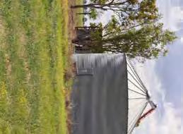
20 largely defined by agricultural crop production with very sparse individual trees occurring around small dams or within cultivated fields. Plate 2. Typical view across north west portion of the Project site (from Barton Plains Road) GREEN BEAN DESIGN l a n d s c a p e a r c h I t e c t s PO Box 3178 Austral NSW
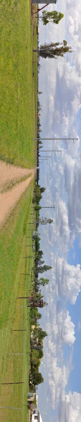
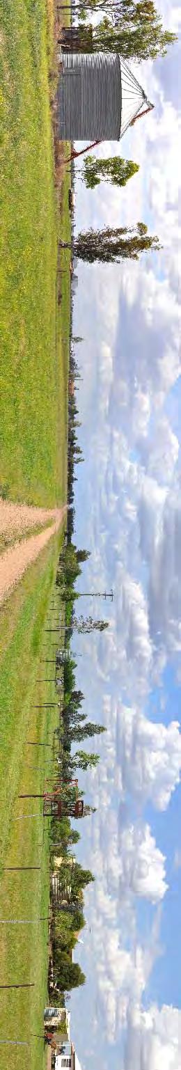
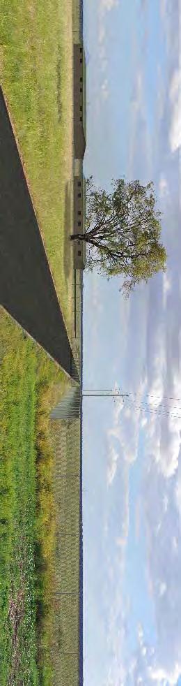
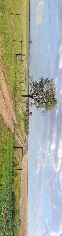
21 Panorama Photographs SECTION Panorama Photographs A series of photographs were taken during the course of the fieldwork to illustrate existing views in the vicinity of the Project and a number of view locations close to residents and publically accessible areas. The photographs were taken with a tripod mounted digital SLR camera and individual photographs digitally stitched together to form a segmented panoramic image to provide a visual illustration of the existing view from each photo location. The real world coordinate location for each panoramic photograph was recorded with a hand held GPS unit to an accuracy of around plus or minus two meters. Additional information including the bearing or direction of each photograph, time of day and prevailing weather conditions was also recorded. The panoramic photographs presented in this LVIA have been annotated to identify key features or structures located within the existing view, and indicatively illustrate the general extent of the Project. The panoramic photograph locations are illustrated in Figure 6, and the panoramic photographs illustrated in Figures 7 to 11. The panoramic photographs are not to be confused with the photomontages. The panoramic photographs do not include a representation or model of the power station structures. GREEN BEAN DESIGN l a n d s c a p e a r c h I t e c t s PO Box 3178 Austral NSW
22
23
24
25
26
27
28 Landscape Character Areas and Sensitivity Assessment SECTION Landscape Character Areas As part of the LVIA process it is important to understand the nature and sensitivity of different components of landscape character, and to assess them in a clear and consistent process. For the purpose of this LVIA, landscape character is defined as the distinct and recognisable pattern of elements that occur consistently in a particular type of landscape (The Countryside Agency and Scottish Natural Heritage 2002). This LVIA has identified four Landscape Character Areas (LCA s), which generally occur within the viewshed of the Project. The LCA s represent areas that are relatively consistent and recognisable in terms of their key landscape elements and physical attributes; which may include a combination of topography/landform, vegetation/landcover, land use and built structures (including settlements and local road corridors). Whilst the assessment of landscape sensitivity is largely based on a systematic description and analysis of landscape characteristics, the LVIA acknowledges that individuals and some members of the local community would place higher values on the local landscape which may transcend preferences (likes and dislikes) and include personal, cultural as well as other parameters, to evaluate landscape sensitivity. For the purpose of this LVIA the LCA s have been identified as: LCA 1 Rural agricultural; LCA 2 Rural residential; LCA 3 Agricultural/industrial; and LCA 4 Transmission line and transport corridors. 6.2 Landscape Sensitivity Assessment The British Landscape Institute describes landscape sensitivity as the degree to which a particular LCA can accommodate change arising from a particular development, without detrimental effects on its character. The assessment of landscape sensitivity is based upon an evaluation of the physical attributes identified within each LCA, both singularly and as a combination that gives rise to the landscape s overall robustness and the extent to which it could accommodate the Project. The criteria used to determine landscape sensitivity are outlined in Table 3 and based on current good practice employed in visual assessment. Landscape sensitivity is a relative term, and the intrinsic landscape values of the GREEN BEAN DESIGN l a n d s c a p e a r c h I t e c t s PO Box 3178 Austral NSW
29 landscape surrounding the Project may be considered of a higher or lower sensitivity than other areas in the northern New South Wales region. Table 3 Landscape Sensitivity Assessment Criteria Landscape Sensitivity Assessment Criteria Characteristic Aspects indicating lower sensitivity to the Project development Aspects indicating higher sensitivity to the Project development Landform and scale: patterns, complexity and consistency Large scale landform Simple Featureless Absence of strong topographical variety Small scale landform Distinctive and complex Human scale indicators Presence of strong topographical variety Landcover: patterns, complexity and consistency Simple Predictable Smooth, regular and uniform Complex Unpredictable Rugged and irregular Settlement and human influence Concentrated settlement pattern Presence of contemporary structures (e.g. utility, infrastructure or industrial elements) Dispersed settlement pattern Absence of modern development, presence of small scale, historic or vernacular settlement Intervisibility with adjacent landscapes Limited views into or out of landscape Neighbouring landscapes of low sensitivity Weak connections, self contained area and views Simple large scale backdrops Prospects into and out from high ground or open landscape Neighbouring landscapes of high sensitivity Contributes to wider landscape Complex or distinctive backdrops The criteria set out in Table 3 have been used to evaluate each of the LCA s using sensitivity grades of higher, medium or lower. The sensitivity of overall grades of higher, medium or lower were determined using the following definitions: High Key characteristics of the LCA may be adversely impacted by the Project, and may result in major alterations to perceived characteristics of the landscape. The degree to which the landscape may accommodate the Project would potentially result in a number of perceived uncharacteristic and significant changes. GREEN BEAN DESIGN l a n d s c a p e a r c h I t e c t s PO Box 3178 Austral NSW


30 Medium Some characteristics of the LCA may be altered by the Project, although the landscape may have the capability to absorb some change. The degree to which the landscape may accommodate the Project would potentially result in the introduction of prominent elements but may be accommodated to some degree. Low The characteristics of the LCA are generally robust, and would be less affected by the Project. The degree to which the landscape may accommodate the Project would not significantly alter existing landscape character. 6.3 LCA 1 Rural Agricultural Areas Plate 3. Typical photos across rural agricultural areas Landform and scale Rural agricultural areas occur across large scale and open landscape. Patterns and complexity are simple in nature with little variation in topography. Views are occasionally interrupted by limited areas of vegetation along field boundaries and drainage lines. Landcover Landcover is predictable and defined by the predominant agricultural economy of the region with cultivated areas contributing to an overall smooth and uniform cover. Settlement and human influence Settlement is dispersed with simple large scale backdrops provided by adjoining rural agricultural areas. The landscape contains a range of contemporary structures including roads, fences, agricultural buildings and structures as well as transmission lines. Intervisibility There is a generally high level of visibility between this LCA and adjoining areas; however, backdrops to views are simple and large scale in nature toward areas that are low in sensitivity. Landscape Sensitivity The landscape sensitivity for the Rural Agricultural Landscape Character Area has been determined as Low. GREEN BEAN DESIGN l a n d s c a p e a r c h I t e c t s PO Box 3178 Austral NSW


31 6.4 LCA 2 Rural Residential Plate 4. Typical photos toward rural residential dwellings Landform and scale Rural residential dwellings are located within the large scale and open landscape surrounding the Project site. Patterns and complexity are simple in nature with little variation in topography. Views are occasionally interrupted by vegetation along field boundaries, drainage lines as well cultural planting surrounding dwellings installed as wind breaks or privacy screens. Landcover Landcover is predictable and defined by surrounding agricultural areas with cultivated gardens surrounding the majority of rural dwellings contributing to an overall smooth and uniform cover. Settlement and human influence Settlement is sparse and dispersed with simple large scale backdrops provided by adjoining rural agricultural areas. The landscape contains a range of contemporary structures including residential dwellings, roads, fences, agricultural buildings and structures. Intervisibility There is a generally high level of visibility between this LCA and adjoining areas; however, backdrops to views are simple and large scale in nature toward areas that are low in sensitivity. Landscape Sensitivity The landscape sensitivity for the Rural Residential Landscape Character Area has been determined as Low. 6.5 LCA 3 Agricultural & Industrial Development Plate 5. Typical photos toward agricultural and industrial structures GREEN BEAN DESIGN l a n d s c a p e a r c h I t e c t s PO Box 3178 Austral NSW
32 Landform and scale Agricultural and industrial areas occur to the south of Moree and north of the Project site within a simple and large scale landscape. Patterns and complexity are simple in nature with little variation in topography. Views are occasionally punctuated by vegetation or screened by large scale structures depending on the location of the viewer. Landcover Landcover is predictable and defined by the agricultural nature of the industrial development. Settlement and human influence Settlement is sparse and generally set back from industrial structures. The landscape contains a range of contemporary structures including roads, fences, agricultural buildings and structures as well as transmission lines. Intervisibility There is a moderate level of visibility between this LCA and adjoining areas with backdrops to views created by simple and large scale in nature toward areas that are low in sensitivity. Landscape Sensitivity The landscape sensitivity for the Agricultural and Industrial Development Landscape Character Area has been determined as Low. 6.6 LCA 4 Transport and Transmission Line Corridors Plate 6. Typical photos along transmission line and transport corridors Landform and scale Transport and transmission line corridors tend to pass through large scale and open landscape areas. Patterns and complexity are simple in nature with little variation in topography. Views are occasionally interrupted by lines of vegetation and buildings approaching the Moree industrial area. Landcover Landcover is predictable and defined by the predominant agricultural economy of the region with overall smooth and uniform cover. GREEN BEAN DESIGN l a n d s c a p e a r c h I t e c t s PO Box 3178 Austral NSW
33 Settlement and human influence Settlement is largely dispersed and generally set back from transport and transmission line corridors with backdrops provided by adjoining rural agricultural areas and industrial infrastructure to the south of Moree. Intervisibility There is a generally high level of visibility between this LCA and adjoining areas; however, backdrops to views are simple and large scale in nature toward areas that are low in sensitivity. Landscape Sensitivity The landscape sensitivity for the Transport and Transmission Line Landscape Character Area has been determined as Low. GREEN BEAN DESIGN l a n d s c a p e a r c h I t e c t s PO Box 3178 Austral NSW
34 Visual Assessment SECTION Introduction The potential visibility of the Project is largely dependent on a number of criteria that include: The visibility or extent to which the Project structures would be visible from surrounding areas; The degree of visual contrast between the Project structures and the capability of the surrounding landscape to visually accommodate the Project; The category and type of situation from which people may view the Project (examples of view categories include residents or motorists); The distance between people and the Project; The potential number of people with a view toward the Project from any one location; The duration of time people may view components of the Project from any static or dynamic view location; and The visual sensitivity of people surrounding the Project. An overall determination of visual impact at each view location has also been assessed and determined against the criteria outlined in Table 3 below: Table 3 - View Location Assessment Criteria Criteria Definition Category of Viewer Static Dynamic Residence Motorist or passenger Number of Viewers High Moderate Low >500 people per day people per day <100 people per day View Distance Long Medium Short Very short Solar Farm >5km 2km 5km 500m 2km <500m Transmission Line >1km 500 1km m <200m Period of View Long term Moderate term Short term > 4 hours 1 4 hours hour GREEN BEAN DESIGN l a n d s c a p e a r c h I t e c t s PO Box 3178 Austral NSW
35 Long Distance Table 4 - Visibility Criteria Matrix Medium Distance Short Distance Very Short Distance Period of View L M S L M S L M S L M S High No. of Viewers Moderate No. of Viewers Low No. of Viewers M L L H M M H H M H H H L L L M M L H M M H H M L L L M L L M M L H M L Period of View L=Long term, M=Moderate term, S=Short term Levels of visibility L=low, M=medium and H=high The visibility criteria matrix is used as a guide to determine visual impact. The visual impact for each view location is also considered against other factors, which include the sensitivity and VAC of the view category. The general relationship between view category and its potential level of sensitivity is outlined in Table 5: Table 5 View Sensitivity View Category Sensitivity Residential Properties Pedestrians (recreational) Public Recreational Space Rural employment/farming Motorists Business (commercial) Industry Highest Sensitivity Lower Sensitivity The overall visual impact has been determined by considering the combined outcomes of visibility for each view location together with the sensitivity of the landscape within which the view is located. The visual impact is expressed as a visibility rating of High, Moderate, Low or Nil. For the purposes of this LVIA visibility ratings have been defined as: High The construction and operation of the Project may result in a very prominent physical change to the landscape, and includes the potential for proximate views toward extensive portions of the Project from sensitive view locations. Moderate The construction and operation of the Project may result in a noticeable physical change to the landscape although the Project would not appear to be substantially different in scale and character to the existing landscape from surrounding view locations. GREEN BEAN DESIGN l a n d s c a p e a r c h I t e c t s PO Box 3178 Austral NSW
36 Low The construction and operation of the Project is unlikely to result in a prominent change to the landscape and views from surrounding locations toward the Project may be difficult to distinguish from elements within the surrounding landscape. Nil The construction and operation of the Project would not create a noticeable change to the landscape and is unlikely to result in views toward the Project from surrounding view locations. The visual impact ratings in brackets ( ) within the Table 4 Visibility Matrix indicate a potential visual impact rating that would be likely to occur subject to an assessment from private property. GREEN BEAN DESIGN l a n d s c a p e a r c h I t e c t s PO Box 3178 Austral NSW
37
38 7.2 Visibility Matrix Table 4 presents the results of the visual assessment from the various potential residential view locations identified during the field inspection. The view locations are illustrated in Figure 12. Table 4 Visibility Matrix Residential Views VIEW LOCATION CATEGORY OF VIEWER APPROX. DISTANCE TO SOLAR PANELS APPROX. PERIOD OF VIEW NUMBER OF VIEWERS LANDSCAPE SENSITIVTY PROJECT VISIBILITY VISUAL IMPACT RATING R1 Resident 4.3km Varies with daily occupancy but potential for long term views. R2 Resident 2km Varies with daily occupancy but potential for long term views. R3 Resident 1.1km Varies with daily occupancy but potential for long term views. R4 Resident 1.7km Varies with daily occupancy but potential for long term views. Low Low Distant views north from residence toward the Project site are generally screened by a combination of landform and vegetation. No views toward the proposed 132kV transmission line. Low Low Mid distance views east from residence toward the Project site are partially screened by a combination of landform (rising embankment to the Newell Highway) and vegetation surrounding the dwelling. No views toward the 132kV transmission line. Low Low Views from residence extend east toward the Project site, but components within the Project are generally obscured by distance. Potential distant views toward the 132kV transmission line poles. Low Low Views from residence toward the Project site are generally screened by vegetation within and surrounding the residential property boundary. No views toward the 132kV transmission line. Nil Nil Low Low (Nil) GREEN BEAN DESIGN l a n d s c a p e a r c h I t e c t s PO Box 3178 Austral NSW
39 VIEW LOCATION CATEGORY OF VIEWER APPROX. DISTANCE TO SOLAR PANELS APPROX. PERIOD OF VIEW NUMBER OF VIEWERS LANDSCAPE SENSITIVTY PROJECT VISIBILITY VISUAL IMPACT RATING R5 Resident 2km Varies with daily occupancy but potential for long term views. R6 Resident 2.6km Varies with occupancy. R7 Resident 3.2km Varies with daily occupancy but potential for long term views. R8 Resident 4km Varies with daily occupancy but potential for long term views. R9 Resident 4.7km Varies with daily occupancy but potential for long term views. Low Low Views from residence toward the Project site are generally screened by vegetation within and surrounding the residential property boundary. No views toward the 132kV transmission line. Low Low Views from residence toward the Project site are generally screened by vegetation within and surrounding the residential property boundary. No views toward the 132kV transmission line. Low Low Views from residence toward the Project site are generally screened by vegetation within and surrounding the residential property boundary. No views toward the 132kV transmission line. Low Low Views from residence toward the Project site are generally screened by vegetation within and surrounding the residential property boundary. No views toward the 132kV transmission line. Low Low Views from residence toward the Project site are generally screened by vegetation within and surrounding the residential property boundary. No views toward the 132kV transmission line. Low (Nil) Low (Nil) Low (Nil) Low (Nil) Low (Nil) GREEN BEAN DESIGN l a n d s c a p e a r c h I t e c t s PO Box 3178 Austral NSW
40 VIEW LOCATION CATEGORY OF VIEWER APPROX. DISTANCE TO SOLAR PANELS APPROX. PERIOD OF VIEW NUMBER OF VIEWERS LANDSCAPE SENSITIVTY PROJECT VISIBILITY VISUAL IMPACT RATING R10 Residents 3km Varies with daily occupancy but potential for long term views. Low Low Views from residence toward the Project site are generally screened by vegetation within and surrounding the residential property boundary. No views toward the 132kV transmission line. Low (Nil) R11 Resident 2.8km Varies with daily occupancy but potential for long term views. R12 Resident 840m Varies with daily occupancy but potential for long term views. R13 Resident 1km Varies with daily occupancy but potential for long term views. Low Low Views from residence toward the Project site are generally screened by vegetation within and surrounding the residential property boundary. No views toward the 132kV transmission line. Low Low Views extend south from the residence toward the north portion of the Project including views toward the PV panels beyond the security fence. Views would also take in other project infrastructure including buildings and electrical infrastructure. The 132kV transmission line would be visible to the west of the residence, as well as portions extending north and south along Barton Plains Road toward Burrington Road and the Solar Power Station. Low Low Views extend south from the residence toward the north portion of the Project including views toward the PV panels beyond the security fence. Views would also take in other project infrastructure including buildings and electrical infrastructure. The 132kV transmission line would be partially visible, but generally screened by vegetation surrounding the dwelling. Low (Nil) Moderate to High Moderate GREEN BEAN DESIGN l a n d s c a p e a r c h I t e c t s PO Box 3178 Austral NSW
41 VIEW LOCATION CATEGORY OF VIEWER APPROX. DISTANCE TO SOLAR PANELS APPROX. PERIOD OF VIEW NUMBER OF VIEWERS LANDSCAPE SENSITIVTY PROJECT VISIBILITY VISUAL IMPACT RATING R14 Resident 1.4km Varies with daily occupancy but potential for long term views. Low Low Potential views south from residence toward the Project site are screened by vegetation surrounding the dwelling, as well as the residential dwelling and cultural planting to the south. Low R15 Resident 1.7km Varies with daily occupancy but potential for long term views. R16 Resident 2.6km Varies with daily occupancy but potential for long term views. Low Low Potential views extend south from the residence toward the north portion of the Project site, including views toward the PV panels beyond the security fence. Views would also take in other project infrastructure including buildings and electrical infrastructure. The 132kV transmission line would be visible along portions of Barton Plains Road. Low Low Distant views south from residence toward the Project site are screened by vegetation surrounding the dwelling, as well as the residential dwelling and cultural planting to the south. Low Low R17 Residents 2.1km Varies with daily occupancy but potential for long term views. Low Low Views from residences toward the Project site area are generally screened by vegetation within and surrounding residential property boundaries. Medium distance but generally restricted views toward the 132kV transmission line. Low GREEN BEAN DESIGN l a n d s c a p e a r c h I t e c t s PO Box 3178 Austral NSW
42 VIEW LOCATION CATEGORY OF VIEWER APPROX. DISTANCE TO SOLAR PANELS APPROX. PERIOD OF VIEW NUMBER OF VIEWERS LANDSCAPE SENSITIVTY PROJECT VISIBILITY VISUAL IMPACT RATING R18 Resident 1.8km Varies with daily occupancy but potential for long term views. R19 Residents south of Burrington Road 1.2km Varies with daily occupancy but potential for long term views. R20 Residents 1.3km Varies with daily occupancy but potential for long term views. R21 Resident 1.2m Varies with daily occupancy but potential for long term views. R22 Resident 1.2km Varies with daily occupancy but potential for long term views. Low Low Views from residence toward the Project site are generally screened by vegetation within and surrounding the residential property boundary. Medium distance but generally restricted views toward the 132kV transmission line. Low Low Potential views south from residences toward the Project site occur across open and cleared farmland. Views would extend to north extent of PV panels beyond security fence as well as warehouse and office buildings. Medium distance views toward the 132kV transmission line would extend along a portion of Barton Plains Road. Low Low Views from residences toward the Project site are generally screened by vegetation within and surrounding the residential property boundary. No views toward the 132kV transmission line. Low Low Views south west to west from residence toward the Project site are partially screened by tree planting within the property boundary. Views toward the 132kV transmission line Low Low Potential views west from residence toward the Project site are generally screened by tree planting surrounding the dwelling. Views toward the 132 kv transmission line are generally screened by tree planting surrounding the dwelling. Low (Nil) Low to Moderate Low (Nil) Low Low (Nil) GREEN BEAN DESIGN l a n d s c a p e a r c h I t e c t s PO Box 3178 Austral NSW
43 VIEW LOCATION CATEGORY OF VIEWER APPROX. DISTANCE TO SOLAR PANELS APPROX. PERIOD OF VIEW NUMBER OF VIEWERS LANDSCAPE SENSITIVTY PROJECT VISIBILITY VISUAL IMPACT RATING R23 Resident 1km Varies with daily occupancy but potential for long term views. R24 Resident 1.1km Varies with daily occupancy but potential for long term views. R25 Resident 1km Varies with daily occupancy but potential for long term views. R26 Resident 1.1km Varies with daily occupancy but potential for long term views. Low Low Potential views west from residence toward the Project site are generally screened by tree planting surrounding the dwelling. Views toward the 132 kv transmission line are generally screened by tree planting surrounding the dwelling. Low Low Potential views west from residence toward the Project site are generally screened by tree planting surrounding the dwelling. Views toward the 132 kv transmission line are generally screened by tree planting surrounding the dwelling. Low Low Potential views west from residence toward the Project site are generally screened by tree planting surrounding the dwelling. Views toward the 132 kv transmission line are generally screened by tree planting surrounding the dwelling. Low Low Potential views west from residence toward the Project site are generally screened by tree planting surrounding the dwelling. Views toward the 132 kv transmission line are generally screened by tree planting surrounding the dwelling. Low (Nil) Low (Nil) Low (Nil) Low (Nil) GREEN BEAN DESIGN l a n d s c a p e a r c h I t e c t s PO Box 3178 Austral NSW
44 VIEW LOCATION CATEGORY OF VIEWER APPROX. DISTANCE TO SOLAR PANELS APPROX. PERIOD OF VIEW NUMBER OF VIEWERS LANDSCAPE SENSITIVTY PROJECT VISIBILITY VISUAL IMPACT RATING R27 Resident 800m Varies with daily occupancy but potential for long term views. R28 Resident 3km Varies with daily occupancy but potential for long term views. R29 Resident 4km Varies with daily occupancy but potential for long term views. R30 Resident 4.3km Varies with daily occupancy but potential for long term views. R31 Resident 3km Varies with daily occupancy but potential for long term views. Low Medium Potential views west to north west from residence toward the Project site are generally screened by tree planting around the dwelling, together with large agricultural sheds and structures to the west of the dwelling. Distant and partial views toward the 132kV transmission line. Low Medium Views from residences toward the Project site are generally screened by vegetation within and surrounding the residential property boundary. No views toward the 132kV transmission line. Low Medium Views from residences toward the Project site are generally screened by vegetation within and surrounding the residential property boundary. No views toward the 132kV transmission line. Low Medium Views from residences toward the Project site are generally screened by vegetation within and surrounding the residential property boundary. No views toward the 132kV transmission line. Low Medium Views from residence toward the Project site are generally screened by vegetation within and surrounding the residential property boundary. No views toward the 132kV transmission line. Low (Nil) Low (Nil) Low (Nil) Low (Nil) Nil GREEN BEAN DESIGN l a n d s c a p e a r c h I t e c t s PO Box 3178 Austral NSW
45 VIEW LOCATION CATEGORY OF VIEWER APPROX. DISTANCE TO SOLAR PANELS APPROX. PERIOD OF VIEW NUMBER OF VIEWERS LANDSCAPE SENSITIVTY PROJECT VISIBILITY VISUAL IMPACT RATING R32 Resident 4.3km Varies with occupancy. Low Medium No views toward the Project site. Restricted views toward the 132kV transmission line. Low (Nil) R33 Residents 4.4km Varies with daily occupancy but potential for long term views. Low Medium No views toward the Project site. Restricted views toward the 132kV transmission line. Low (Nil) R34 Residences (Moree South) Varies Varies with daily occupancy but potential for long term views. Low Medium No views toward the Project site. Generally restricted views toward the 132kV transmission line within the context of surrounding industrial development. Low GREEN BEAN DESIGN l a n d s c a p e a r c h I t e c t s PO Box 3178 Austral NSW
46 Table 5 presents the results of the visual assessment from the various potential transport corridor and public space view locations identified during the field inspection. The view locations are illustrated in Figure 12. Table 5 Visibility Matrix Transport Corridors and Public Space VIEW LOCATION CATEGORY OF VIEWER APPROX. DISTANCE TO SOLAR PANELS APPROX. PERIOD OF VIEW NUMBER OF VIEWERS LANDSCPE SENSITIVTY PROJECT VISIBILITY VISUAL IMPACT RATING M1 North West railway Passenger Varies (Generally very short, following the western boundary of the Project site). Short term <4 minutes Low (2 passenger services a day, one inbound and one outbound between Moree and Sydney). Low Short term views toward the Project site from trains travelling north and south along the western boundary of the Project site. Views would extend east across the Project site, including Medium and Distant views toward the 132kV transmission line, buildings and electrical infrastructure. Low M2 Newell Highway (northbound) Motorist Varies (between 1 and 2km) Short term <4 minutes High Low Short term views toward the Project site, from vehicles travelling north to north west along the Newell Highway, are generally indirect from the road corridor alignment. Views toward the Project site would be partially screened by occasional roadside vegetation and the low railway embankment. Low No views toward the 132kV transmission line from the Newell Highway travelling north toward the Burrington Road junction. GREEN BEAN DESIGN l a n d s c a p e a r c h I t e c t s PO Box 3178 Austral NSW
47 VIEW LOCATION CATEGORY OF VIEWER APPROX. DISTANCE TO SOLAR PANELS APPROX. PERIOD OF VIEW NUMBER OF VIEWERS LANDSCPE SENSITIVTY PROJECT VISIBILITY VISUAL IMPACT RATING M3 Newell Highway (southbound) Motorist Varies (between 1 and 3km) Short Term <4 minutes High Low Short term views toward the Project site, from vehicles travelling south to south west along the Newell Highway, are generally indirect from the road corridor alignment. Views toward the Project site would be partially screened by occasional roadside vegetation and the low railway embankment. No views toward the 132kV transmission line from the Newell Highway travelling south toward, and beyond, the Burrington Road junction. Low M4 Wallanol Road southeast Motorist Varies (between 1 and 5km) Short term <2 minutes Low Low Short term views from vehicles travelling south east along Wallanol Road toward the Newell Highway junction. Views toward the Project site are largely screened by vegetation between the Highway and the railway line. No views toward the 132kV transmission line. Low M5 Burrington Road view southwest Motorist Varies (between 1.2 and 2km) Short term <1 minute Low Low Short term and indirect views from vehicles travelling north west and south east along Burrington Road. Views toward the Project site would be occasionally screened by roadside vegetation. The 132kV transmission line would span Burrington Road north of Barton Plains Road, and then follow to the north of the Burrington Road corridor for approximately 2km. Short term views would extend along the length of the 132kV transmission line for Low GREEN BEAN DESIGN l a n d s c a p e a r c h I t e c t s PO Box 3178 Austral NSW
48 VIEW LOCATION CATEGORY OF VIEWER APPROX. DISTANCE TO SOLAR PANELS APPROX. PERIOD OF VIEW NUMBER OF VIEWERS LANDSCPE SENSITIVTY PROJECT VISIBILITY VISUAL IMPACT RATING this portion of Burrington Road. M6 Burrington Road view west to north west Motorist Varies (between 3.5 and 4km) Short term <2 minutes Low Low Short term and indirect distant views from vehicles travelling north and south along Burrington Road. Views toward the Project site are occasionally screened by roadside vegetation. No views toward the 132kV transmission line. Low M7 Keams Road Motorist Short term <2 minutes Low Low Short term and indirect views toward the Project site would be partially obscured by vegetation surrounding residential dwellings on Keams Road. Low M8 Barton Plains Road Motorist Short term <2 minutes Low Low Short term and direct views toward the Project site from vehicles travelling south along Barton Plains Road. Short term and direct views toward 132kV transmission line from vehicles travelling north and south along Barton Plains Road. Low to Moderate M9 Newell Highway view east Motorist Short term <3 minutes High Low Short term views from vehicles travelling north and south along the Newell Highway toward the proposed transmission line are partially screened by existing buildings and but indirectly visible south of Moree Airport for approximately 2km. Low GREEN BEAN DESIGN l a n d s c a p e a r c h I t e c t s PO Box 3178 Austral NSW
49 7.3 Visual Impact Assessment A total of 34 residential view locations (including grouped residences) were identified through the desk top aerial photograph and mapping study. An assessment of the visual impact rating for each residential view location determined that: 1 of the 34 view locations have been determined to have a high visual impact rating. 2 of the 34 view locations has been determined to have a moderate visual impact rating; 28 of the 34 view locations have been determined to have a low visual impact rating; 3 of the 34 view locations have been determined to have a nil visual impact rating; and 21 of the residential view locations were determined to have a low (nil) visual impact rating. This LVIA also considered potential visual impacts for motorists and rail passengers at 9 locations surrounding the Project site (M1 to M9). This LVIA determined that the potential visual impact for all motorists and rail passengers travelling along local roads, the Newell Highway and portions of the North West railway line would be low. For motorists, the determination of a low visibility rating generally results from a combination of the very short period of view available from vehicles travelling at the permitted road speeds (generally between 80 and 100 kilometres per hour on the main roads and highways) and the partially restricted view beyond the majority of the road corridors due to roadside tree planting or tree cover. Elevated views from trains travelling along the North West railway line would extend across the site; however, views would be transitory in nature for a short period of time. GREEN BEAN DESIGN l a n d s c a p e a r c h I t e c t s PO Box 3178 Austral NSW
50 Photomontage SECTION Photomontage In order to illustrate how the Project may appear following construction, photomontages were prepared from 2 typical view locations. The photomontage locations were selected to illustrate views from areas where view locations (including residences) were determined to have a moderate to high visual impact. A number of other view locations were considered for photomontage but were not selected due to the overall low level of Project visibility and the likelihood that the Project would not be discernable in a photographic illustration. The extent and overall potential for Project visibility from other surrounding areas is illustrated in the panorama photographs Figures 7 to 11. The photomontage locations are shown in Figure 2, and include views from: Location A Barton Plains Road, View north along 132kV transmission line easement. Location B Barton Plains Road, view south toward the Solar Power Station and 132kV transmission line. The photomontages were generated through the following steps: Photographs were taken from each of the view locations and recorded with GPS coordinate data. A digital SLR at 50mm focal length camera was used to take the photographs, as this is generally accepted as most closely representing the primary view cone of the human eye. Heights of existing and proposed structures were estimated by reference to surrounding features in the landscape. AutoCAD software was used for modelling visually significant components of the Project structures which were then pasted into panoramic images stitched from the individual site photographs. Finally the images were imported to Adobe Photoshop for final surface texturing to place the proposed structures within the context of the foreground and background elements of the photographs. The photomontages are illustrated in Figures 13 and 14 and are provided for illustrative purposes only. All structure locations and heights are indicative of the final arrangement which may vary depending on a range of detail design criteria. GREEN BEAN DESIGN l a n d s c a p e a r c h I t e c t s PO Box 3178 Austral NSW
51
52
53 Sunglint and Glare SECTION Introduction This LVIA has considered a number of issues concerned with the potential for reflectivity of sunlight from the PV panels. Sunlight reflection is often perceived as a significant issue in relation to solar facilities; however, a primary function for the PV panels is to absorb sunlight energy rather than reflect it. The technical process in manufacturing PV panels includes an anti reflection coating to the solar cell wafers within each panel that minimises potential for sunlight reflection. The BP Solar PV panels also use high transmission, low iron glass, which absorbs greater amounts of light and produces less reflectance than standard glass. Primarily sunlight reflection would be visible as either sunglint or glare. 9.2 Sunglint Sunglint is a phenomenon that results from the direct reflection of sunlight (also known as specular reflection) from a reflective surface that would be visible when the sun reflects off the surface of the PV panels at the same angle that a person is viewing the PV panel surface. 9.3 Glare Sunlight reflection from the polycrystalline structure of the individual PV panels may also result in glare (also known as diffuse reflection). Glare from a reflective surface occurs where sunlight is reflected at many angles rather than a single angle observed as sunglint. There are a number of factors that determine both intensity and extent of sunglint and glare and include: the distance and orientation of the PV panels relative to surrounding view locations; the offset horizontal angle of the PV panels; time of day and seasonal variations defining position and angle of sunlight; the occurrence of cloud cover; the amount of particulate matter in the atmosphere (moisture, dust, smoke etc ) which may diffuse sunlight; and the presence of screening vegetation relative to view locations. Moree airport is approximately 6.5km to the north of the Project, and sunglint or glare is unlikely to impact aircraft operations at the airport; however, the occurrence of sunglint or glare for aircraft passing over the Project would be dependent on the aircrafts altitude and directional bearing to the Project. Solar panels have been installed at airports in the United States of America and Europe. San Francisco International Airport is in the process of installing 2,800 solar panels on the roof of the Domestic Terminal 3 building in addition to an existing solar panel installation on the roof of the GREEN BEAN DESIGN l a n d s c a p e a r c h I t e c t s PO Box 3178 Austral NSW
54 airports engineering building. BP Solar installed a PV solar panel system on the roof of the Terminal 2 Check in Concourse at Munich International Airport, and neither this, or any solar panel installation at, or in proximity to an airport, has had any significant impact on aircraft operations including take off and landing. The measure of how strongly various materials can reflect light from sources such as the sun (the albedo ) has been measured (Power Engineers 2010 and Sunpower Corporation 200) and determined as a reflected energy percentage. These studies have shown that common materials utilised within rural/agricultural environments, including steel, standard glass and plexiglass can have higher reflected energy percentages than materials employed for PV glass panels. Based on the results of previous assessments for PV solar power projects and studies carried out in the United States of America and Europe, the potential for sunglint and glare would not be expected to have a significant impact on residential dwellings surrounding the Project area, or upon motorists or people travelling through or over the surrounding landscape. GREEN BEAN DESIGN l a n d s c a p e a r c h I t e c t s PO Box 3178 Austral NSW
55 Night Time Lighting SECTION Introduction The Project would require lighting to be installed for night time illumination around the operation and maintenance facilities, car park and onsite substation. Lighting would be low level and directional within the site to minimise the potential for light spill onto adjoining areas. In addition to the standard level of lighting required for normal security and safety, lighting may also be required for scheduled or emergency maintenance around the operations and maintenance buildings, substation and PV panel areas Existing light sources A small number of existing night time light sources occur in the vicinity of the Project site, and includes residential and general lighting around agricultural and industrial installations. Localised lighting is associated with a small number of residential dwellings located within the Project viewshed, but lighting is unlikely to be visually prominent and does not emit any significant illumination beyond immediate areas surrounding residential and agricultural buildings. Lights from vehicles travelling along the local roads and the Newell Highway provide dynamic and temporary sources of light Potential visual impact The categories of potential view locations that would be impacted by night time lighting include residents and motorists. Irrespective of the total number of visible lights sources associated with the Project, lighting is more likely to be noticeable from exterior areas surrounding residences rather than from within residences where at night time room lights tend to reflect and mirror internal views in windows, or curtains and blinds tend to be drawn. Night time lighting associated with the Project is unlikely to have a significant visual impact on the majority of motorists travelling along local roads; the duration of visibility would tend to be very short and partially screened by some landform elements and vegetation along some sections of local road corridors. GREEN BEAN DESIGN l a n d s c a p e a r c h I t e c t s PO Box 3178 Austral NSW
56 Pre-construction and construction SECTION Potential visual impacts There are potential visual impacts that may occur during both pre construction and construction phases of the Project. The construction phase is likely to occur over a four year period; however, construction activity is only likely to occur for nine months of each year. The extent and nature of preconstruction and construction activities would vary at different locations and at different times within the Project area. The key pre construction and construction activities that may be visible from areas surrounding the Project include: Ongoing detailed site assessment including sub surface geotechnical investigations; Various civil works to upgrade local roads and access point; Construction facilities, including portable structures and laydown areas; Various construction and directional signage; Excavation and earthworks; and Various construction activities including erection of buildings, solar panels and substation with associated electrical infrastructure works. The majority of pre construction and construction activities, some of which would result in physical changes to the landscape are generally temporary in nature and for the most restricted to various discrete areas within or beyond the immediate Project area. The majority of pre construction and construction activities would be unlikely to result in an unacceptable level of visual impact for their duration and temporary nature. GREEN BEAN DESIGN l a n d s c a p e a r c h I t e c t s PO Box 3178 Austral NSW
57 Cumulative Impact Assessment SECTION Cumulative Impact Assessment An assessment of cumulative environmental impacts considers the potential impact of a proposal in the context of existing development and future development to ensure that any potential environmental impacts are not considered in isolation. Direct cumulative visual impacts may occur where two or more similar developments have been constructed within the same locality, and may overlap and are simultaneously viewed from the same view location. Indirect cumulative visual impacts can also arise as a result of multiple developments being observed from the same view location, but do not overlap or occur within a single field of view. Sequential cumulative visual impacts may also arise as a result of multiple developments being observed at different locations during the course of a journey (e.g. from a vehicle travelling along a highway or from a network of local roads), which may form an impression of greater magnitude within the construct of short term memory. There are other solar power developments being considered in the landscape surrounding Moree which are competing for funding under the Federal Governments Clean Energy Initiative Solar Flagships Program. Irrespective of which projects may receive Government funding, it is possible that more than one solar power station facility could be constructed within the local area. Given the relatively low level of visibility associated with the Project within the flat and large scale landscape surrounding Moree, it is unlikely that direct or indirect cumulative impacts would occur. Multiple solar power station projects may result in sequential cumulative visual impacts; however, a visual assessment for a proposed solar farm development to the east of Moree airport determined an overall low visual impact and, if visible on a journey that included views toward the BP Solar Power Station Project, would not result in an overall increased level of visual impact. There are existing industrial/agricultural developments located within the landscape between the Project and Moree and include: Moree Industrial Park; Moree Airport; Bulk Wheat Storage Facility; Bio Energy Plan; Duvanant s Cotton Gin; Saleyards; and Waste Management Facility. GREEN BEAN DESIGN l a n d s c a p e a r c h I t e c t s PO Box 3178 Austral NSW
58 The developments located in Figure 15 (and illustrated in the panorama photographs Figures 7 to 11), significantly differ in shape and form to the Project and present potential for taller and more visible skyline views than the majority of the Projects components. Approximately 7km of the 132kV transmission line would be visible against a backdrop of other electrical distribution and transmission lines, and would span an existing 66kV and 132kV transmission line south of the Moree Zone Substation. Although existing transmission lines would occur within the viewshed of the proposed 132kV transmission line, they would tend to be visible within an increasingly industrialised landscape as the transmission lines approach the Substation. Given the relatively limited number of sensitive view locations from which all transmission lines would be visible, the overall cumulative visual impact has been determined as low. GREEN BEAN DESIGN l a n d s c a p e a r c h I t e c t s PO Box 3178 Austral NSW
59
APPENDIX K. Visual Impact Assessment
 APPENDIX K Visual Impact Assessment Integra Open Cut Project VISUAL IMPACT ASSESSMENT Prepared for URS Australia Pty Ltd 3 rd December 2008 GREEN BEAN DESIGN l a n d s c a p e a r c h I t e c t s GREEN
7. The Landscape. 7.1 Introduction. Environmental Impact Statement (EIS) Scoping Report
 Scoping Report") 7. The Landscape 7.1 Introduction The purpose of this section of the EIS Scoping Report is to describe the scope of work and methods to be applied in the identification and assessment of landscape and
7. The Landscape 7.1 Introduction The purpose of this section of the EIS Scoping Report is to describe the scope of work and methods to be applied in the identification and assessment of landscape and
Genex Kidston Connection Project: Draf t Environmental Assessment Report Powerlink Queensland
 : Draf t Environmental Assessment Report Powerlink Queensland Chapter 14 \\autsv1fp001\projects\605x\60577456\6. Draft Docs\6.1 Reports\4. Compiled draft 17 September\Covers\Chapters\Ch 14.docx Rev ision
Chapter 7: Landscape and Visual Impact Assessment
 Chapter 7: Landscape and Visual Impact Assessment Landscape Character and Visual Impact Assessment 7. Landscape Character and Visual Impact Assessment... 2 7.1 Methodology... 2 7.2 Assessment Findings...
WELLINGTON HOSPITAL DESIGN GUIDE TABLE OF CONTENTS
 WELLINGTON HOSPITAL DESIGN GUIDE TABLE OF CONTENTS 1.0 Introduction Page 2 The Place of Wellington Hospital 2 The Future of the Hospital 2 2.0 The Intention of the Design Guide 3 3.0 Analysis 4 General
Definition of Cumulative Landscape and Visual Effects
 SECTION 5: GUIDANCE FOR ASSESSING CUMULATIVE LANDSCAPE AND VISUAL EFFECTS 5.1 Although this landscape sensitivity and capacity study has identified that parts of the National Park may be able to accommodate
Visual Impact Assessment - December Figure 5.2: Viewshed analysis of the haul route.
 Visual Assessment - December 2014 Figure 5.2: Viewshed analysis of the haul route. 21 Baobab Resources (Pty) Ltd 5.1.3 Visual Exposure The following can be deduced from the Figure 5.1: the area to the
Development in the setting of the Cotswolds AONB
 COTSWOLDS CONSERVATION BOARD POSITION STATEMENT Development in the setting of the Cotswolds AONB.1. Introduction Areas of Outstanding Natural Beauty (AONBs) are designated by the Government for the purpose
Section Three, Appendix 16C Medium Density Housing, Design Assessment Criteria (Residential 8A zone)
") APPENDIX 16C MEDIUM DENSITY HOUSING, DESIGN ASSESSMENT CRITERIA (RESIDENTIAL 8A ZONE) PURPOSE OF APPENDIX 16C (RESIDENTIAL 8A ZONE) In the Residential 8A Zone the following are defined as restricted discretionary
APPENDIX 16C MEDIUM DENSITY HOUSING, DESIGN ASSESSMENT CRITERIA (RESIDENTIAL 8A ZONE) PURPOSE OF APPENDIX 16C (RESIDENTIAL 8A ZONE) In the Residential 8A Zone the following are defined as restricted discretionary
3. Highway Landscaping Assessment
 Guidelines for Highway Landscaping 3-1 3. Highway Landscaping Assessment 3.1 Introduction This section outlines the steps necessary to assess the highway landscaping component of a state highway construction
Wind energy development in the South Pennines landscape
 Wind energy development in the South Pennines landscape Programme for today Background Policy context South Pennines landscape Impacts of wind energy development The South Pennines Wind Energy Landscape
Salhouse Parish Council, 11 th November Response to Planning Application
 Salhouse Parish Council, 11 th November 2013 Response to Planning Application 20131408 Summary Salhouse Parish Council (SPC) has received via Broadland District Council a Planning Application for a 5MWp
Visual Impact Rating Form - Instructions
 Visual Impact Rating Form Instructions Project Name: Baron Winds Project EDR Project No: 13039 Date: 05.16.17 Reference: Visual Impact Rating Form - Instructions These instructions are intended to guide
Assessment of Landscape, Visual and Natural Character Effects
 Assessment of Landscape, Visual and Natural Character Effects Consent Footprint Amendments Mangamaunu Half Moon Bay Okiwi Bay South Report prepared for: New Zealand Transport Agency and KiwiRail Holdings
RURAL ZONE - POLICY. Rural Zone Policy. Issue: Rural Environment. Ruapehu District Plan Page 1 of 8
 Rural Zone Policy RU2 RURAL ZONE - POLICY RU2.1 Introduction The natural resources of the rural environment in the Ruapehu District provide the basis for the existing and potential character, intensity
3.1 This evidence is based on the landscape and visual impact assessment included in Chapter 10 and Appendix I of the EIS.
 LANDSCAPE & VISUAL 1 QUALIFICATIONS AND EXPERIENCE 1.1 My name is Raymond Holbeach and I am a Regional Director for RPS Planning & Environment with full responsibility for management of the RPS Belfast
Guidance for Wind Turbine Development in the Dorset AONB
 Photo 1: Rew Manor Farm, West Dorset, chalk downland landscape (Planning application ref: 1/D/09/001280 1 ) Scale & siting: 12m to hub / 16m to blade tip. A well sited small scale turbine, grouped with
Guidance for Wind Turbine Development in the Dorset Area of Outstanding Natural Beauty
 DRAFT January 2012 Guidance for Wind Turbine Development in the Dorset Area of Outstanding Natural Beauty Photo 1: Rew Manor Farm, West Dorset, chalk downland landscape (Planning application ref: 1/D/09/001280
Toddington Central Bedfordshire Stage 3 Green Belt Study December 2017
 Toddington Central Bedfordshire Stage 3 Green Belt Study December 2017 Site: ALP086 - Middle Lakes, Toddington Site size (ha): 2.83 Site: ALP086 - Middle Lakes, Toddington Site size (ha): 2.83 Site description
TIDAPA Structure Plan
 TIDAPA Structure Plan Prepared by Tract Consultants 28 MARCH 2017 0217-0074 Table of Contents 01 STRATEGIC CONTEXT Executive Summary Regional Context Page 3 Page 4 02 LOCAL CONTEXT Aerial Photograph Local
Section Three, Appendix 17C Multiple Unit Housing Design Assessment Criteria
 APPENDIX 17C MULTIPLE UNIT HOUSING DESIGN ASSESSMENT CRITERIA Purpose of Appendix 17C In the Residential 9 Zone the construction and use of multiple household units located within the Multiple Household
Tables of Criteria and Matrices for Landscape Assessment (LSCA & LVIA)
") Carly Tinkler CMLI Environmental, Landscape and Colour Consultancy 46 Jamaica Road, Malvern, Worcestershire WR14 1TU Tel +44 (0)7711 538854 carlytinkler@hotmail.co.uk Tables of Criteria and Matrices for
Carly Tinkler CMLI Environmental, Landscape and Colour Consultancy 46 Jamaica Road, Malvern, Worcestershire WR14 1TU Tel +44 (0)7711 538854 carlytinkler@hotmail.co.uk Tables of Criteria and Matrices for
Nob Hill Pipeline Improvements Project EIR
 Section 3.1 Aesthetics This section addresses the visual aspects that may affect the views experienced by the public, including the potential to impact the existing character of each area that comprises
3.1 AESTHETICS Background and Methodology
 3.1 AESTHETICS 3.1.1 Background and Methodology 3.1.1.1 Regulatory Context The California Environmental Quality Act (CEQA) requires that project sponsors evaluate the project s potential to cause aesthetic
Section 3b: Objectives and Policies Rural Environment Updated 19 November 2010
 Page 1 of Section 3b 3b RURAL ENVIRONMENT 3b.1 Introduction The Rural Environment comprises all the land outside of the Residential, Town Centre and Industrial Environments. Most land within the District
WELCOME GYPSY LANE. Wider Site Location plan. Proposals for the development of LAND OFF FOXLYDIATE LANE WEBHEATH. Proposals for the development of
 WELCOME The developers are preparing an outline planning application for a residential led development and need the community s views in order to develop the proposals further WHAT IS PROPOSED? A high
LANDSCAPE CHARACTER AND VISUAL CAPACITY STUDY
 LANDSCAPE CHARACTER AND VISUAL CAPACITY STUDY PROPOSED RESIDENTIAL ALLOCATION BARHAM COURT FARM BARHAM, KENT REF. NO. 3046_ RP_001 STATUS: INFORMATION REVISIONS DOCUMENT CREATED: 10/04/32014 REVISION A
2A District-wide Policies
 2A Introduction This Chapter contains policies which are relevant to subdivision, use and development activities occurring across all zones and areas of the District. The policies in this Chapter implement
PART 05 VISUAL SETTING
 PART 05 VISUAL SETTING 5.1 How to use the Visual Settings 5.2 Views from the Headland 5.3 Creek Foreshore Park Looking North 5.4 Bridge looking North 5.5 Bridge looking West 5.6 Bridge looking South 5.7
List of Policies. SESPlan. None applicable. Consolidated Scottish Borders Local Plan 2011: POLICY G1 - QUALITY STANDARDS FOR NEW DEVELOPMENT
 List of Policies Local Review Reference: 15/00021/RREF Planning Application Reference: 15/00616/FUL Development Proposal: Installation of 16no solar photovoltaic (PV) panels to roof Location: Raebank,
M7 Naas to Newbridge Bypass Upgrade Scheme. Landscape and Visual Impact Assessment Brief of Evidence
 M7 Naas to Newbridge Bypass Upgrade Scheme Landscape and Visual Impact Assessment Brief of Evidence Presented by Richard Butler, Cunnane Stratton Reynolds Landscape Architect: BL Arch (University of Pretoria,
Garden Bridge Planning Application
 Planning Application Additional Verified photomontages and assessment September 2014 Contents Page 1 Visual assessment 2 1.1 Introduction 2 1.2 Baseline 2 1.3 Potential effects and good environmental
4 RESIDENTIAL ZONE. 4.1 Background
 4 RESIDENTIAL ZONE 4.1 Background The residential areas within the City are characterised by mainly lowrise dwellings sited on individual allotments. Past architectural styles, settlement patterns and
16 LANDSCAPE AND VISUAL IMPACT
 16 LANDSCAPE AND VISUAL IMPACT 16.1 Introduction The term landscape refers primarily to the visual appearance of an area, including its shape, form and colour and the interaction of these elements to create
Guidance Note for Landscape and Visual Assessment. June 2018
 Guidance Note for Landscape and Visual Assessment June 2018 Contents Seventeen Seventy, Gladstone region ii 00 Foreword iv 01 Introduction 3 02 Background 4 03 Terminology and language 6 04 Principles
APPENDIX 7.1: LANDSCAPE AND VISUAL IMPACT ASSESSMENT METHODOLOGY
 APPENDIX 7.1: LANDSCAPE AND VISUAL IMPACT ASSESSMENT METHODOLOGY 1.0 Introduction 1.1 Landscape and Visual Impact Assessment (LVIA) is a tool used to systematically identify and assess the nature and significance
SUSTAINABLE MANAGEMENT
 . Sustainable Management.1 The Concept of Sustainable Management The concept of sustainable management recognises there are limits to the use of natural and physical resources and there is a need to balance
DEVELOPMENT MANAGEMENT REPORT
 ITEM A08-1 DEVELOPMENT MANAGEMENT REPORT TO: BY: DATE: DEVELOPMENT: SITE: WARD: APPLICATION: APPLICANT: Development Management Committee Development Manager Proposed live/work unit in connection with existing
SECTION ONE North East Industrial Zone Design Guide Palmerston North City Council June 2004
 SECTION ONE North East Industrial Zone Design Guide Palmerston North City Council June 2004 young heart easy living 1 Preface Industrial areas are a very important component of the economic well-being
I209 Quay Park Precinct
 I209. Quay Park I209.1. Precinct description The Quay Park Precinct is located on reclaimed land at the eastern end of the city centre and along the City Centre waterfront. It is dissected to the east
Section 6A 6A Purpose of the Natural Features and Landscapes Provisions
 Section 6A 6A Purpose of the Natural Features and Landscapes Provisions This Chapter addresses the protection and management of natural features and landscapes within the City. The City has a number of
The Place Solar Farm
 The Place Solar Farm Environmental Statement Non-Technical Summary 28 August 2014 Produced for Prepared by St John s House Queen Street, Manchester M2 5JB Contents Contents... 2 1 Introduction... 3 1.1
Proposed Southland District Plan 2012 Appeal Version October 2016
 S e c t i o n 3. 5 - F i o r d l a n d / R a k i u r a Z o n e The Fiordland/Rakiura Zone encompasses the Fiordland and Rakiura National Parks and part of Mt Aspiring National Park. It also includes areas
SOUTH CAMBRIDGESHIRE DISTRICT COUNCIL. Executive Director (Operational Services) Corporate Manager (Planning and New Communities)
 Corporate Manager (Planning and New Communities)") SOUTH CAMBRIDGESHIRE DISTRICT COUNCIL REPORT TO: Planning Committee 12 January 2011 AUTHOR/S: Executive Director (Operational Services) Corporate Manager (Planning and New Communities) Notes: S/1848/10
SOUTH CAMBRIDGESHIRE DISTRICT COUNCIL REPORT TO: Planning Committee 12 January 2011 AUTHOR/S: Executive Director (Operational Services) Corporate Manager (Planning and New Communities) Notes: S/1848/10
I611. Swanson North Precinct
 I611. Swanson North Precinct I611.1. Precinct Description Swanson North is located in the north eastern foothills of the Waitakere Ranges. It is outside the Waitakere Ranges Heritage Area Act and the Waitakere
IV. ENVIRONMENTAL IMPACT ANALYSIS B. AESTHETICS 1. VIEWS
 IV. ENVIRONMENTAL IMPACT ANALYSIS B. AESTHETICS 1. VIEWS ENVIRONMENTAL SETTING Existing Visual Character Project Site The project site is located at 10250 Wilshire Boulevard in the Westwood community of
Viewpoint 1. Location: View from Murch Road on the north eastern boundary of Application Site. Viewing south / southwest.
 Application Site (eastern field) Former site of St. Cyres Lower School Murch Road 1 Location: View from Murch Road on the north eastern boundary of Application Site. Viewing south / southwest. Baseline
ESKOM PROPOSED CONSTRUCTION OF A 88KV POWER LINE BETWEEN CLOCOLAN AND FICKSBURG VISUAL IMPACT ASSESSMENT DRAFT REPORT
 ESKOM PROPOSED CONSTRUCTION OF A 88KV POWER LINE BETWEEN CLOCOLAN AND FICKSBURG VISUAL IMPACT ASSESSMENT DRAFT REPORT April 2013 PREPARED BY PO BOX 2122, WESTVILLE, 3630, SOUTH AFRICA FOR ACER Environmental
I602. Birdwood Precinct
 I602. Birdwood Precinct I602.1. Precinct description The Birdwood Precinct applies to an area west of Don Buck Road and south of Red Hills Road in west Auckland. It incorporates subdivision and development
Lower Sensitivity. VS Classification Level 2: Exposed Upland/Plateau (86%)/ Upland Valleys (10%)
/ Upland Valleys (10%)") S09 Y Mignient Reproduced from the Ordnance Survey map with the permission of Ordnance Survey on behalf of the Controller of Her Majesty s Stationery Office, Crown copyright Licence No. 100023387 Location
S09 Y Mignient Reproduced from the Ordnance Survey map with the permission of Ordnance Survey on behalf of the Controller of Her Majesty s Stationery Office, Crown copyright Licence No. 100023387 Location
St Michaels C of E Junior & Infant School, Nantmel Grove, Bartley Green, Birmingham, B32 3JS
 Committee Date: 06/03/2014 Application Number: 2013/08595/PA Accepted: 19/11/2013 Application Type: Full Planning Target Date: 14/01/2014 Ward: Bartley Green St Michaels C of E Junior & Infant School,
22.15 OUTDOOR ADVERTISING SIGNAGE POLICY
 22.15 OUTDOOR ADVERTISING SIGNAGE POLICY This policy applies to all land where a planning permit is required to construct or display a sign under the provisions of the Kingston Planning Scheme. 22.15-1
Barvills Solar Farm Environmental Statement Non-Technical Summary
 Barvills Solar Farm Environmental Statement Non-Technical Summary 13 March 2015 Produced for Prepared by St John s House Queen Street, Manchester M2 5JB Contents Contents... 2 1 Introduction... 3 1.1 Development
Rural (Urban Expansion) Environment
 Environment") RUEE.1 Rural (Urban Expansion) Environment Subsequent to the receipt of appeals, a 'marked up' version of the Proposed District Plan was prepared. The provisions of the Proposed Version of the Plan subject
RUEE.1 Rural (Urban Expansion) Environment Subsequent to the receipt of appeals, a 'marked up' version of the Proposed District Plan was prepared. The provisions of the Proposed Version of the Plan subject
2.0 AREA PLANS. Lakeside Business District. Lakeside Business District Land Use Categories:
 Lakeside Business District Lakeside Business District Land Use Categories: Campus Commercial Campus Commercial means a mixture of uses which includes corporate offices, office parks, hotels, commercial,
9 Archaeology & Cultural Heritage
 High Clachaig Wind Farm Scoping Report Page 56 9 Archaeology & Cultural Heritage 9.1 Introduction Cultural heritage in this context means the above- and below-ground archaeological resources, built heritage,
Lower Sensitivity. VS Classification Level 2: Exposed Upland/Plateau
 S05 Y Moelwynion Reproduced from the Ordnance Survey map with the permission of Ordnance Survey on behalf of the Controller of Her Majesty s Stationery Office, Crown copyright Licence No. 100023387 Location
LANDSCAPE AND VISUAL IMPACT ASSESSMENT
 HARE STREET ROAD BUNTINGFORD LANDSCAPE AND VISUAL IMPACT ASSESSMENT Prepared by ACD Chartered Landscape Architects for Written By: SJD Checked By: JS Date: Document File Ref: TWNT18550lvia Revision: A-
Lower Sensitivity. VS Classification Level 2: Exposed Upland/Plateau
 S02 Y Carneddau Reproduced from the Ordnance Survey map with the permission of Ordnance Survey on behalf of the Controller of Her Majesty s Stationery Office, Crown copyright Licence No. 100023387 Location
Western Sydney Parklands Australia s Largest Urban Park
 Western Sydney Parklands Australia s Largest Urban Park 37 WLA 1 MAGAZINE 21 38 WESTERN SYDNEY PARKLANDS AUSTRALIA S LARGEST URBAN PARK Large urban parks have dual roles to play in meeting the demands
4 Residential and Urban Living Zones
 4 Residential and Urban Living Zones Refer to Chapters 11 to 20 for additional rules that may apply to these zones. 4.1 OBJECTIVES AND POLICIES Objective Res1 Policy 1 Policy 2 Policy 3 Policy 4 Policy
CHAPTER 10 AESTHETICS
 CHAPTER 10 AESTHETICS CHAPTER 10 AESTHETICS This section identifies and evaluates key visual resources in the project area to determine the degree of visual impact that would be attributable to the project.
LANDMAP Methodology Overview
 LANDMAP Methodology Overview June 2017 Jill Bullen, Senior Landscape Specialist jill.bullen@cyfoethnaturiolcymru.gov.uk 0300 065 4706 (Please note this is an information document and not a training presentation)
INTRODUCTION. Land south of Bishopswood Lane, Tadley
 0 INTRODUCTION THE SITE Introduction Gladman Developments Ltd. has successfully invested in communities throughout the UK over the past 0 years, developing high quality and sustainable residential, commercial
STATEMENT OF OBJECTION TO THE PROPOSED DEVELOPMENT OF LAND AT CHURCH CLIFF DRIVE FILEY
 STATEMENT OF OBJECTION TO THE PROPOSED DEVELOPMENT OF LAND AT CHURCH CLIFF DRIVE FILEY You will be aware that Scarborough borough council have adopted a new local plan that includes land at Church Cliff
4.3 Dudley Area Plan. Introduction. History and Existing Character. Desired Future Character for Dudley
 4.3 Dudley Area Plan Introduction The suburb of Dudley has developed as a result of various circumstances including its topography, history and mineral resources. Dudley development has been identified
Assessing the impact of smallscale wind energy proposals on the natural heritage
 Scottish Natural Heritage Assessing the impact of smallscale wind energy proposals on the natural heritage Guidance March 2016 Version 3 1 Contents 1. Introduction. 3 2. Encouraging a spatial approach
Oxford Green Belt Study. Summary of Final Report Prepared by LUC October 2015
 Oxford Green Belt Study Summary of Final Report Prepared by LUC October 2015 Project Title: Oxford Green Belt Study Client: Oxfordshire County Council Version Date Version Details Prepared by Checked by
PLANNING, DESIGN AND ACCESS STATEMENT
 PLANNING, DESIGN AND ACCESS STATEMENT PROPOSED FREE RANGE CHICKEN SHED AT LAND NORTH OF GLANMYDDYFI, PENTREFELIN, LLANDEILO On behalf of Our Ref: 0161.a Date: February 2018 Prepared by: JDE 1.0 INTRODUCTION...3
SECTION 7A: WHAKARONGO RESIDENTIAL AREA
 SECTION 7A: WHAKARONGO RESIDENTIAL AREA CONTENTS 7A.1 Introduction 1 7A.2 Resource Management Issues 1 7A.3 Objectives and Policies 1 7A.4 Methods 4 7A.5 Residential Zone 4 7A.5.1 Rules: Controlled Activities
The Proposed Auckland Unitary Plan (notified 30 September 2013)
") 3 Business zones Introduction There are 10 business zones in the Unitary Plan: City Centre Metropolitan Centre Town Centre Local Centre Neighbourhood Centre Mixed Use General Business Business Park Light
3 Business zones Introduction There are 10 business zones in the Unitary Plan: City Centre Metropolitan Centre Town Centre Local Centre Neighbourhood Centre Mixed Use General Business Business Park Light
Longbridge Town Centre Phase 2 Planning Application
 Longbridge Town Centre Phase 2 Planning Application Non-Technical Summary of the Environmental Statement December 2013 Introduction A full application for Planning Permission has been submitted to Birmingham
Infill Residential Design Guidelines
 Infill Residential Design Guidelines Adopted March 23, 2004 Amended September 10, 2013 City of Orange Community Development Department Planning Division Phone: (714) 744-7220 Fax: (714) 744-7222 www.cityoforange.org
RESIDENTIAL ACTIVITY PERFORMANCE STANDARDS
 Preferred Options Consultation Q&A Sheet RESIDENTIAL ACTIVITY PERFORMANCE STANDARDS What are the key goals for managing the design of residential buildings in the Second Generation Plan (2GP)? The key
Rannoch 132 / 33 kv Substation Extension
 Who we are Scottish and Southern Energy Power Distribution is part of the SSE plc group of companies. We own, maintain and invest in the networks in the north of Scotland the electricity transmission network
Tāhuhu whakaruruhau ā-taone The sheltering ridge pole
 B2. Tāhuhu whakaruruhau ā-taone - Urban growth and form B2.1. Issues Tāhuhu whakaruruhau ā-taone The sheltering ridge pole Auckland s growing population increases demand for housing, employment, business,
LEEDS SITE ALLOCATIONS PLAN MATTER 3 GREEN BELT KCS DEVELOPMENT AUGUST 2017
 LEEDS SITE ALLOCATIONS PLAN MATTER 3 GREEN BELT KCS DEVELOPMENT AUGUST 2017 Smith Limited Suite 9C Joseph s Well Hanover Walk Leeds LS3 1AB T: 0113 2431919 F: 0113 2422198 E: planning@peacockandsmith.co.uk
BUSHFIRE MANAGEMENT PLAN (BMP)
") Established 1907 BUSHFIRE MANAGEMENT PLAN (BMP) December 2015 Version Date Section Modified 1 February 2005 All 2 3 December 2010 December 2015 All All Reason for Modification Original Management Plan
Established 1907 BUSHFIRE MANAGEMENT PLAN (BMP) December 2015 Version Date Section Modified 1 February 2005 All 2 3 December 2010 December 2015 All All Reason for Modification Original Management Plan
Rural (Urban Expansion) Environment
 Environment") RUEE.1 Rural (Urban Expansion) Environment Index RUEE.1 RUEE.1.1 RUEE.1.2 RUEE.1.3 RUEE.1.4 RUEE.2 RUEE.2.1 RUEE.2.2 RUEE.2.3 RUEE.2.4 RUEE.3 Rural (Urban Expansion) Environment Description and Expectations
RUEE.1 Rural (Urban Expansion) Environment Index RUEE.1 RUEE.1.1 RUEE.1.2 RUEE.1.3 RUEE.1.4 RUEE.2 RUEE.2.1 RUEE.2.2 RUEE.2.3 RUEE.2.4 RUEE.3 Rural (Urban Expansion) Environment Description and Expectations
- - - Key Characteristics
 S23 Dyffryn Dysynni Reproduced from the Ordnance Survey map with the permission of Ordnance Survey on behalf of the Controller of Her Majesty s Stationery Office, Crown copyright Licence No. 100023387
North West Rail Link - Environmental Assessment Urban Design and Visual Assessment Prepared for Transport Infrastructure Development Corporation
 North West Rail Link - Environmental Assessment Urban Design and Visual Assessment Prepared for Transport Infrastructure Development Corporation November 2006 HASSELL Ltd 007 711 435 88 Cumberland Street
ROCHFORD LOCAL DEVELOPMENT FRAMEWORK: Sustainability Appraisal/ Strategic Environmental Assessment. Rochford Core Strategy Preferred Options Document
 ROCHFORD LOCAL DEVELOPMENT FRAMEWORK: Sustainability Appraisal/ Strategic Environmental Assessment Non Technical Summary Rochford Core Strategy Preferred Options Document October 2008 SUSTAINABILITY APPRAISAL
The analysis of key visual characteristics and attributes that contribute to variations in the
 15.0 CHIGWELL/CHIGWELL ROW 15.1 Overview 15.1.1 Chigwell and Chigwell Row settlements are situated in the south of Epping Forest District, to the south of Abridge and southwest of Stapleford Abbotts. Both
Derry City and Strabane District Council Planning Committee Report
 Derry City and Strabane District Council Planning Committee Report COMMITTEE DATE: 20.12.2017 APPLICATION No: APPLICATION TYPE: PROPOSAL: LOCATION: APPLICANT: AGENT: A/2014/0495/F Full Construction of
Draft Eastern District Plan
 Draft Eastern District Plan Submission_id: 31238 Date of Lodgment: 13 Dec 2017 Origin of Submission: Online Organisation name: Turrulla Gardens Pty Ltd C/- Mecone Organisation type: Industry First name:
Chapter 13 Residential Areas: Appendices APPENDIX 1 Residential Areas
 Chapter 13 Residential Areas: Appendices Page 1 Chapter 13 Residential Areas: Appendices APPENDIX 1 Residential Areas Design Code for Intensive Housing INTRODUCTION DESIGN ELEMENTS A NEIGHBOURHOOD DESIGN
Lower Sensitivity. VS Classification Level 2: Hills, Lower Plateau & Scarp Slopes (74%)/ Lowland Valleys (17%) / Exposed Upland/Plateau (7%)
/ Lowland Valleys (17%) / Exposed Upland/Plateau (7%)") S06 Coedwig Gwydyr Reproduced from the Ordnance Survey map with the permission of Ordnance Survey on behalf of the Controller of Her Majesty s Stationery Office, Crown copyright Licence No. 100023387 Location
S06 Coedwig Gwydyr Reproduced from the Ordnance Survey map with the permission of Ordnance Survey on behalf of the Controller of Her Majesty s Stationery Office, Crown copyright Licence No. 100023387 Location
BUSHFIRE CONSTRAINTS ASSESSMENT FOR THE SHONE AVENUE WEST DAPTO ROAD NEIGHBOURHOOD PLAN HORSLEY
 BUSHFIRE CONSTRAINTS ASSESSMENT FOR THE SHONE AVENUE WEST DAPTO ROAD NEIGHBOURHOOD PLAN HORSLEY Australian Bushfire Protection Planners Pty Limited ACN 083 085 474 32 Old Dog Trap Road, SOMERSBY 2250 NSW.
Glenn Highway MP DSR. Landscape Narrative
 Glenn Highway MP 34-42 DSR Landscape Narrative Project Landscape Goals The Glenn Highway MP 34-42 Project extends through a variety of landscape types typical to the Matanuska-Susitna Valley. In general,
REMARKABLES PARK ZONE
 .10 Remarkables Park Zone.10.1 Resources, Activities and Values The Remarkables Park Area comprises approximately 150 hectares of perimeter urban land in the vicinity of Frankton and occupies a strategic
AMENDMENTS. Date Effective. Amendment No. Council. DCP 14 Davidson St, Greenacre Page 2
 AMENDMENTS Amendment No. Description Adopted by Council Date Effective DCP 14 Davidson St, Greenacre Page 2 TABLE OF CONTENTS 1.0 INTRODUCTION... 4 1.1 NAME OF THIS PLAN... 4 1.2 COMMENCEMENT OF DEVELOPMENT
IV.B. VISUAL RESOURCES
 IV.B. VISUAL RESOURCES ENVIRONMENTAL SETTING Existing Visual Character Project Site The project site is located at 17331-17333 Tramonto Drive in the Pacific Palisades community of the City of Los Angeles
Ref: A073350/SM/sm Date: 13 September 2013
 Ref: A073350/SM/sm Date: 13 September 2013 Ian Parkinson Development Control Team Leader Planning Portsmouth City Council Civic Offices Guildhall Square Portsmouth PO1 2AY Dear Ian LIGHT & GLEAVE VILLA
I539. Smales 2 Precinct
 I539. Smales 2 Precinct I539.1. Precinct Description The Smales 2 Precinct applies to a 4.8 hectare block of land located on the southern side of Northcote Road and fronting Lake Pupuke, Takapuna. The
Lower Sensitivity. VS Classification Level 2: Exposed Upland/Plateau
 S04 Moel Hebog Reproduced from the Ordnance Survey map with the permission of Ordnance Survey on behalf of the Controller of Her Majesty s Stationery Office, Crown copyright Licence No. 100023387 Location
Chapter 2: OUTLINE PLANNING APPLICATION PROPOSALS. A New Garden Neighbourhood Matford Barton 17
 Chapter 2: OUTLINE PLANNING APPLICATION PROPOSALS A New Garden Neighbourhood Matford Barton 17 2.1. SUMMARY AND STATUS OF THE PROPOSALS 2.1.1. The parameter plans and associated wording in this chapter
CHAPTER 20 VISUAL AMENITY
 Central Eyre Iron Project Mining Lease Proposal CHAPTER 20: VISUAL AMENITY CHAPTER 20 VISUAL AMENITY COPYRIGHT Copyright IRD Mining Operations Pty Ltd and Iron Road Limited, 2015 All rights reserved This
Schedule of Planning Applications Committee Date: 23 May Reference: 06/17/0726/F Parish: Hemsby Officer: Mr J Beck Expiry Date:
 Schedule of Planning Applications Committee Date: 23 May 2018 Reference: 06/17/0726/F Parish: Hemsby Officer: Mr J Beck Expiry Date: 22-05-2018 Applicant: Proposal: Site: Mr Gillett Change of use to the
Summary Note on Landscape and Visual Impact and Mitigation
 East Anglia TWO Offshore Windfarm Appendix 4.4 Summary Note on Landscape and Visual Impact and Mitigation Preliminary Environmental Information Volume 3 Document Reference EA2-DEVWF-ENV-REP-IBR- 000799_004
Draft Ada Street Cardiff Area Plan
 Draft Ada Street Cardiff Area Plan (Draft Amendment to Lake Macquarie Development Control Plan 2014) Exhibition: The draft Area Plan is on public exhibition from 29 February 2016 to 29 March 2016. Submissions: