4.11 Land Use Introduction Environmental and Regulatory Setting Environmental Setting
|
|
|
- Daniel Payne
- 6 years ago
- Views:
Transcription
1 Introduction This section describes the affected environment and environmental consequences related to land use from operations of the NEPA Alternatives. Information regarding land use and planning in the Cities of San Jose and Santa Clara was obtained from the following sources. Envision San Jose 2040 General Plan (City of San Jose 2011a). Envision San Jose 2040 General Plan Environmental Impact Report (City of San Jose 2011b). City of Santa Clara General Plan (City of Santa Clara 2010a). City of Santa Clara General Plan Environmental Impact Report (City of Santa Clara 2010b) Environmental and Regulatory Setting Environmental Setting This section discusses the existing conditions related to land use within the BART Extension vicinity, including the construction staging areas. A broad range of land uses exists along the alignment, including residential, commercial, retail, and industrial uses. There are no agricultural properties located along the alignment, at station locations or parking areas, or at the sites of systems facilities. The BART Extension would begin at the terminus of the Phase I Project, east of U.S. 101 and south of Mabury Road in San Jose, and would terminate at grade in Santa Clara near the Caltrain Station. Figures to show existing land uses at the station sites. Current land uses along the corridor are also shown on the plan and profile drawings in Appendix B of this SEIS/SEIR. Existing land uses are described using the following standard categories. Low-density residential: single-family and one- to two-story housing units. Medium-density residential: apartments, condominiums, and duplex buildings. High-density residential: residential buildings over three stories in height. Light industrial: industrial parks, research and development, and automotive repairs. Heavy industrial: manufacturing warehouses, industrial plants, and freight facilities. General commercial/office: offices, business parks, small businesses, restaurants, clothing stores, and other vendors of general consumer goods. Public/civic/community center: public venues and government-related buildings. School/educational: colleges, universities, and other schools. VTA s BART Silicon Valley Phase II Extension Project
2 Open space/parks: public parks, waterway corridors, and other undeveloped areas. Airport/highway service/transit: transit-related buildings and areas. City of San Jose Connection to Phase I Berryessa Extension Both the Twin-Bore and Single-Bore Options would follow the same tunnel alignment in this location. Land uses along the east side of the alignment are predominantly industrial between Mabury Road and Coyote Creek. South of Coyote Creek is Anne Darling Elementary School, and south of McKee Road land uses are predominately single-family residences. U.S. 101 is located immediately adjacent and to the west of the alignment north of McKee Road. The alignment crosses under U.S. 101 south of McKee Road. Alum Rock/28 th Street Station The Alum Rock/28 th Street Station would be excavated to approximately 40 feet below ground level with the Twin-Bore Option. The top of the Single-Bore Option would be a maximum of approximately 70 feet below ground. Both stations would be below an existing industrial area and within an urban village boundary. Industrial uses are located along the former railroad right-of-way (ROW) and along the west side of U.S Industrial uses are located within the station area. Other industrial buildings, warehouses, and storage yards are located immediately adjacent to the station site. Low- and medium-density residential uses are located across U.S. 101 to the north and east of the station site, as well as to the west of 28 th Street and the former railroad ROW. The Portuguese Band and Social Center is located to the west of the station site, and the Five Wounds National Portuguese Church and associated elementary school are located to the southeast. Commercial uses border the southwestern corner of the station site along Santa Clara Street. Tunnel Alignment near Coyote Creek The Twin-Bore Option would curve slightly north of Santa Clara Street as it passes under Coyote Creek. The Single-Bore Option would remain in line with Santa Clara Street, going under the bridge abutments. Uses along Santa Clara Street from 28 th to 18 th Streets are generally commercial, with residential areas to the north and south of the commercial corridor. The East San Jose Carnegie Branch Library is directly south of the alignment at South 23 rd Street. From 18 th Street heading west into downtown San Jose, land uses are primarily commercial and retail. Older single-family residential neighborhoods are located beyond the commercial strip to the north and south of the alignment. Horace Mann Elementary School is located along the north side of the alignment, and San Jose State University and San Jose City Hall are to the south
3
4
5
6
7
8
9
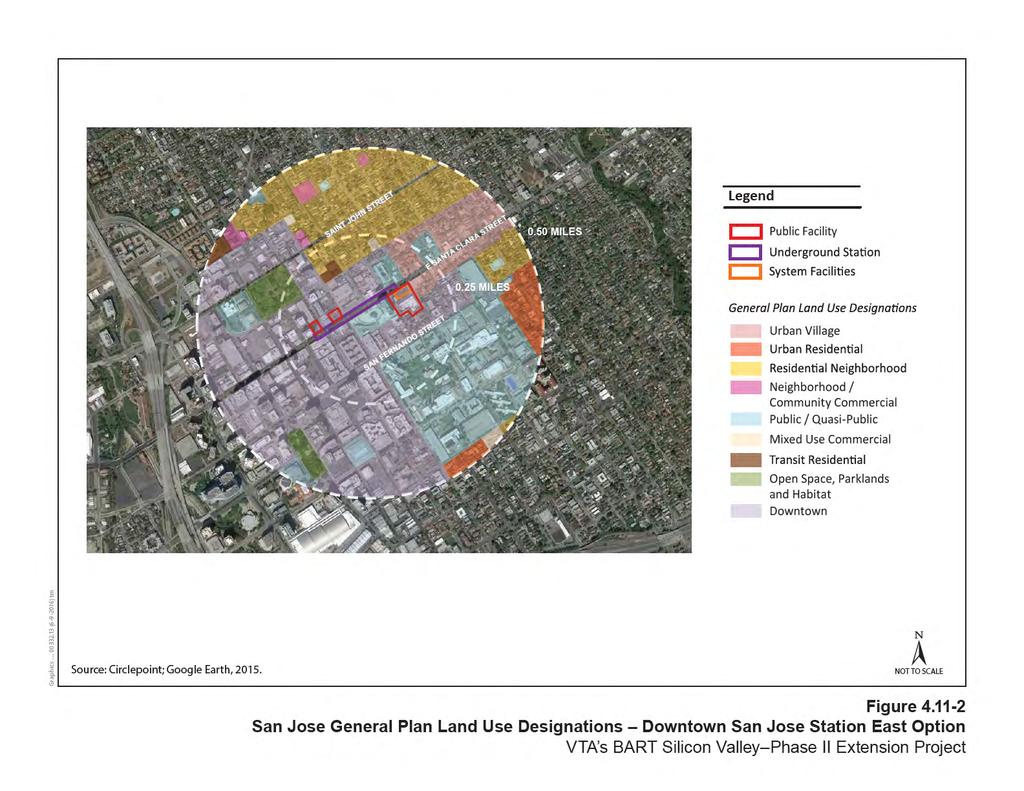
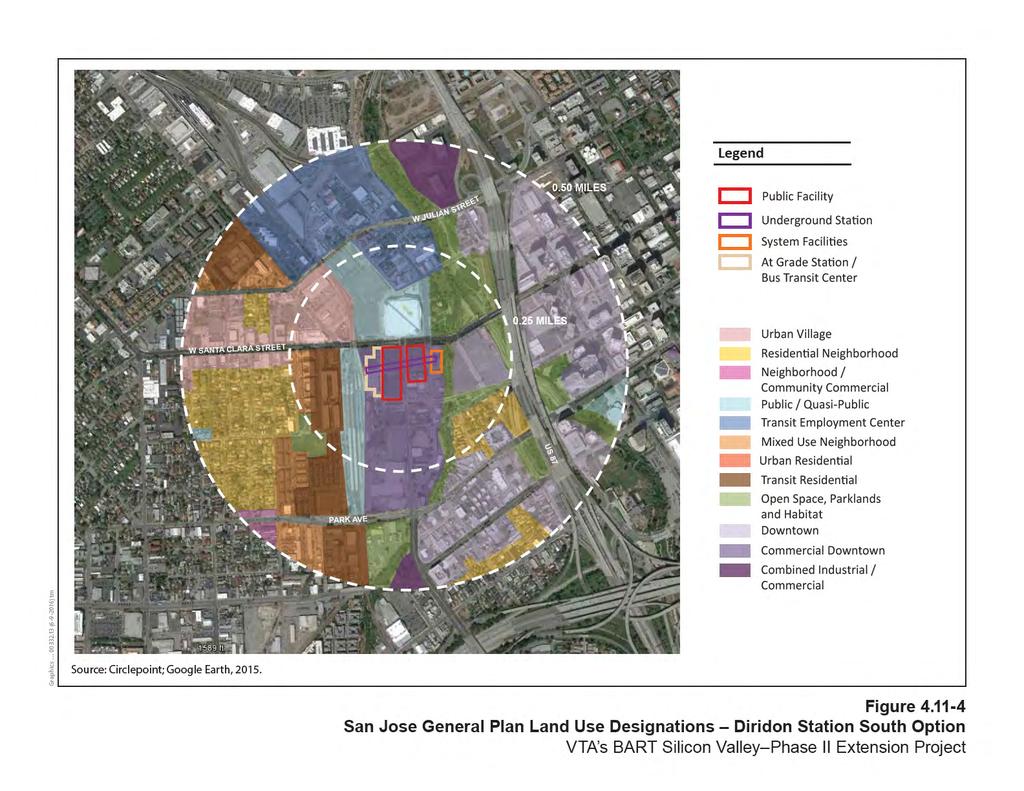
10 Downtown San Jose Station Downtown San Jose contains high-rise office buildings lining Santa Clara Street. These buildings have first floor retail uses that mainly serve downtown employees, residents, and visitors. Downtown is characterized by a strip of retail uses along the street frontage, with older residential uses just beyond the retail corridor. The San Jose State University campus is located one block south of Santa Clara Street between 4 th and 10 th Streets. The San Jose Civic Plaza, including San Jose City Hall, is located south of Santa Clara Street, between 4 th and 6 th Streets. The Museum of Art, Plaza de Cesar Chavez, St. Joseph s Cathedral, San Pedro Square, and several theaters and major hotels are near the new station locations. Santa Clara Street is a busy retail, commercial, and business thoroughfare leading into downtown San Jose. Commercial businesses include many restaurants, bars, retailers, a grocery store, and a gas station. Low- and medium-density residential uses are located to the north of Santa Clara Street, just outside of downtown San Jose. Downtown San Jose Station East Option The Downtown San Jose Station East Option would be excavated to approximately 40 feet below ground level under Santa Clara Street between 5 th and 2 nd Streets with the Twin-Bore Option. The top of the Single-Bore Option would be a maximum of approximately 70 feet below ground. The station would consist of a boarding platform level, a mezzanine one level above, and entrances at street level. Several station portal entrance location options are being evaluated such as in sidewalks along Santa Clara Street near 6 th, 4 th, and 3 rd Streets, alongside commercial and entertainment venues. Downtown San Jose Station West Option The Downtown San Jose Station West Option would be excavated to approximately 40 feet below ground level under Santa Clara Street between 2 nd and Market Streets. The top of the Single-Bore Option would be a maximum of approximately 70 feet below ground. Businesses along this portion of Santa Clara Street include several restaurants, retailers, a bank, and hair salons. The station would consist of a boarding platform level, a mezzanine one level above, and entrances at street level. Several station portal entrance location options from sidewalks on 3 rd Street north of Santa Clara Street, along Santa Clara Street between 2 nd and 3 rd Streets, on 2 nd Street both north and south of Santa Clara Street, north of Santa Clara Street and east of Market Street, and along Market Street south of Santa Clara Street are being evaluated. Diridon Station Land uses near the Diridon Station South and North Options include Guadalupe River Park and Gardens to the north, and low- to medium-density residential, commercial, and industrial uses to the south. Between the station and Stockton Avenue, the land uses are predominately low- to medium-density residential with some park/open space, as well as commercial uses along The Alameda. Industrial land uses are located east of the alignment near the Caltrain corridor. Cahill Park is located one block south of the station on West San Fernando Street
11 Diridon Station South Option The Diridon Station South Option would be located between Autumn Street to the east, the existing Caltrain tracks to the west, Santa Clara Street to the north, and the existing Diridon Caltrain Station to the south. The Diridon Station South Option would be located approximately 40 feet below ground level and would be located slightly south relative to the North Option with the Twin-Bore Option. The top of the Single-Bore Option would be a maximum of approximately 70 feet below ground. The alignments for the Twin-Bore and Single-Bore Options would be the same as they enter and exit the Diridon Station South Option. Primary land uses within the Diridon Station South Option area are industrial and office/commercial, with office/commercial and institutional/education to the west. To the south are industrial uses and residential uses are to the southwest of the station area. Commercial and industrial uses, as well as the Los Gatos Creek are located to the east. The SAP Center is directly north of the station and is anticipated to draw substantial numbers of riders during entertainment and sporting events. Transportation-related infrastructure dominates the landscape within the footprint of the Diridon Station South Option. Diridon Station North Option Under the Twin-Bore Option, the Diridon Station North Option would be located slightly to the east, between the exiting Caltrain tracks to the west and Autumn Street to the east. Excavation for this option would extend approximately 40 feet below ground level. Under the Single-Bore Option, the top of the Diridon Station North Option would be located a maximum of approximately 70 feet below ground level between Montgomery Street to the east, White Street to the west, Santa Clara Street to the north, and the existing Diridon Caltrain Station to the south. The track alignments for the Twin-Bore and Single-Bore Option would also vary slightly as they enter and exit the Diridon Station North Option. Primary land uses within and in the vicinity of the Diridon Station North Option area are the same as described above for the Diridon Station South Option. Continuation of Tunnel Alignment Around Pershing Avenue, all of the options the Twin-Bore and Single-Bore Options and the Diridon Station South and North Options converge back onto the same alignment under Stockton Avenue. The top of the Twin-Bore Option would be approximately 40 feet below ground level and the top of the Single-Bore Option would be approximately 70 feet below ground level. Exiting the stations, the alignment would continue west and cross under the Caltrain tracks. Residential and commercial uses are along the alignment before reaching Stockton Avenue. Residential land uses dominate the southwest side of the alignment, and commercial and industrial uses occupy areas to the northeast approaching Schiele Avenue. Some commercial and institutional uses are also located along the alignment in this area
12 The alignment would continue on the east side of the Caltrain tracks and cross under Interstate 880 (I-880) before ascending and exiting the West Tunnel Portal near Newhall Street. City of Santa Clara Newhall Maintenance Facility Within Santa Clara, the alignment begins north of I-880 and extends to the Santa Clara Station. North of I-880, the uses are primarily industrial, while single-family and multi-story residences are located to the west. The Santa Clara University campus also lies to the west. The Newhall Maintenance Facility would begin north of the West Tunnel Portal at Newhall Street in San Jose and extend to Brokaw Road near the Santa Clara Station in Santa Clara. The facility would be constructed on the former Union Pacific Railroad (UPRR) Newhall Yard that was purchased by VTA in Land uses on the southwest side of the maintenance facility and storage area and across the existing railroad tracks are primarily single-family and multi-family residences. On the northeast side of the storage area there are primarily commercial and industrial uses, such as a home improvement business and an athletic club, as well as Avaya Stadium. Santa Clara Station The Santa Clara Station would be bounded by railroad tracks to the southwest, De La Cruz Boulevard to the northwest, and Coleman Avenue to the northeast near the intersection of Brokaw Road in an area currently occupied by industrial and commercial uses. The station would be at grade, centered at the west end of Brokaw Road, and would contain an at-grade boarding platform with a mezzanine level one level below. The Santa Clara Caltrain Station is located west of the station site. Land uses along the southern and western boundaries of the station site include the Santa Clara Police Station and office and commercial land uses. Santa Clara University occupies a substantial portion of land to the southwest of the station area. There are also medium- and low-density residential developments to the south of the Santa Clara Station site. The station site was formerly a FedEx shipping and receiving facility but is now leased to another tenant. Retail uses are located immediately adjacent to the northwest. Industrial buildings and Mineta San Jose International Airport are located to the north and northeast. The existing Caltrain tracks and station are located southwest of the station Regulatory Setting There are no federal land use regulations that would be applicable to the BART Extension. However, there are several state and local land use regulations applicable to the BART Extension. Please refer to Chapter 6, Section 6.11,, for a summary of state and local land use policies applicable to the BART Extension
13 Methodology The land use analysis of the BART Extension focuses on four primary components: the alignment, the station areas, the support facilities required for operation, and parking areas. The BART Extension is evaluated against the existing and planned developments adjacent to and surrounding the BART Extension in order to evaluate the compatibility of the facilities with neighboring land uses. The land use study area incorporates areas along either side of the alignment and a 0.5-mile radius around the BART stations. An adverse effect on land use would involve physically dividing an established community, conflicting with any applicable land use plan, policy, or regulation of an agency with jurisdiction over the BART Extension Alternative, or conflicting with any applicable habitat conservation plan or natural community conservation plan Environmental Consequences and Mitigation Measures This section identifies impacts and evaluates whether they would be adverse according to NEPA, using the criteria (i.e., context and intensity) identified in Section , Methodology. This section also identifies design commitments to avoid, minimize, or mitigate impacts No Build Alternative The No Build Alternative consists of existing transit and roadway networks and planned and programmed improvements (see Chapter 2, Section 2.2.1, NEPA No Build Alternative, for a list of these projects). The No Build Alternative projects could result in effects on land uses typically associated with transit, highway, bicycle, pedestrian facilities, and roadway projects. These projects are anticipated to cause a similar range of the type and intensity of impacts as caused by the BART Extension Alternative. This would include typically include transportation, noise and vibration, air quality, and land use impacts and associated mitigation measures. However, projects planned under the No Build Alternative would undergo separate environmental review to determine whether these projects would result in adverse effects to surrounding land uses. The No Build Alternative would not be as supportive of regional plans and policies to promote BART use, infill development, and densification around BART stations as would the BART Extension Alternative BART Extension Alternative The final property acquisitions required to construct the BART Extension Alternative may change (i.e., increase or decrease in size, change type, and/or change from permanent to temporary, etc.) during final design. Also, during final design, additional easements may be identified such as temporary construction easements, temporary access easements, and long-term maintenance and access easements. It is the intent of this and previous environmental documents to disclose the potential environmental impacts of acquisitions
14 known at the time the environmental document is prepared while recognizing that some adjustments may be necessary based on final design, working with individual property owners during the acquisition process, and/or during construction. Should additional modifications beyond the scope of this environmental document trigger the need for additional environmental review, the necessary additional environmental analyses will be prepared. Physically Divide an Established Community Community cohesion addresses the degree to which residents feel a sense of belonging to their neighborhood or experience attachment to community groups and institutions as a result of continued association over time. Possible adverse effects of a project on community cohesion include effects on interactions among persons and groups; isolation of certain people from others; and the perceived effect on community quality of life due the creation of a new barrier or physical division within an established community. VTA has taken measures to ensure the public is aware and has been engaged during the design period of the BART Extension. The community offered suggestions and concerns at several public forums, including scoping meetings. During the scoping process for the BART Extension, VTA invited the community to provide input on the BART Extension. VTA conducted three public scoping meetings (on February 12, 17, and 19, 2015) which provided BART Extension-related information to the community and initiated public involvement in the environmental review process. The community offered suggestions and voiced concerns related to several BART Extension components. Such community input has helped to guide the development of BART Extension plans, particularly for aboveground station areas, to minimize adverse community effects of the BART Extension. Alignment The BART Extension is approximately 6 miles long and would pass through the Cities of San Jose and Santa Clara. Of those 6 miles, approximately 5 would be underground. The BART Extension would descend from the connection to Phase I Berryessa Extension into the East Tunnel Portal just north of Las Plumas Avenue. From here, the alignment would travel underground through San Jose before ascending at the West Tunnel Portal north of I-880 near Newhall Street. The alignment would continue to the Santa Clara Station (approximately 0.75 mile) near the existing Santa Clara Caltrain Station. The only tunnel locations where the Twin-Bore and Single-Bore Options would differ would be near Coyote Creek and entering/exiting the Diridon Station North Option. However, both of these portions of the alignment would be underground and vary only slightly; thus the discussion of surrounding land uses is the same for both the Twin-Bore and Single-Bore Options. No new physical barriers would be created within the community surrounding the 5-mile-long underground alignment, and there would be no division of an existing community. The underground alignment would transition from an at-grade alignment into a trench and into a tunnel portal at both the east and west ends of the BART Extension
15 Approximately 1 mile of the alignment would be located aboveground either at grade or in a trench. The aboveground portion of the alignment north of the East Tunnel Portal would be located near U.S. 101 and within an existing industrial area. The portion in Santa Clara would travel within an existing heavily-utilized rail corridor, including passenger service by Altamont Corridor Express, Caltrain, and Capitol Corridor and infrequent Union Pacific Railroad operations. Therefore, neither aboveground segment would create a new division in an existing community. There would be no adverse effect, and mitigation would not be required. Station Locations Alum Rock/28 th Street Station The Alum Rock/28 th Street Station is located within the Five Wounds Urban Village Area and the Five Wounds/Brookwood Terrace BART Station Area Community Concept Plan. This Plan was conceptualized through a collaboration between the City, community, and University of San Jose. This plan envisions the Alum Rock/28 th Street Station as a center for a conceptualized Town Square, and associated pedestrian promenades and mixed use developments. The ultimate goal of the community in designing the Five Wounds/Brookwood Terrace BART Station Area Community Concept Plan was to enhance the area and create a community gathering place with mixed land uses. The Alum Rock/28 th Street Station would be underground and include aboveground facilities, such as street level station entrances, a parking structure, system facilities, and roadway improvements to North 28 th street. The Alum Rock/28 th Street Station would be contained within an approximately 11-acre station campus that is currently in industrial uses. As previously described, the station campus area is surrounded by a mix of industrial, commercial, institutional/civic and residential land uses that all operate independently from each other. The current uses on the site do not provide primary access to adjacent users. The Alum Rock/28 th Street BART Station would replace the existing industrial buildings contained within the station campus; however, it would not take any streets out of the existing roadway network, create new barriers, or divide an existing neighborhood. Buildout of the Alum Rock/28 th Street Station would be consistent with the Five Wounds/Brookwood Terrace BART Station Area Community Concept Plan. Thus, operation of the Alum Rock Station would not substantially disturb the cohesiveness in the area or substantially interfere with community interaction. Furthermore, implementation of this station would increase the availability of transit options and allow for enhanced mobility to surrounding neighborhoods. Therefore, there would be no adverse effect, and no mitigation would be required. Downtown San Jose Station Options Downtown San Jose Station would be located underground and consist of a boarding platform level, a mezzanine one level above, and entrances at street level. Land uses surrounding both station options are primarily institutional/civic, commercial, and residential uses and are located near VTA s Santa Clara Light Rail Station. The current uses around the
16 station options do not provide primary access to adjacent users. Both station options have relatively little aboveground infrastructure; aboveground features would not create a new barrier or substantially interrupt the community interaction in the area. The aboveground features would be designed to blend with the existing urban fabric of the downtown area. The station would not take any streets out of the existing roadway network, remove any residential neighborhoods, or put up barriers between any neighborhoods. Furthermore, implementation of either of the downtown station options would not divide any existing established community in the area. Implementation of a new BART station in downtown San Jose would increase the availability of transit options and allow for enhanced mobility to surrounding neighborhoods. Therefore, there would be no adverse effect, and no mitigation would be required. Diridon Station Options The Diridon Station South and North Options would be located underground and would consist of a boarding platform level, a mezzanine one level above, and entrances at both the east and west ends of the station at street-level portals. Diridon Station is included in the Diridon/Arena Station Area Plan. This plan was the result of a collaboration between the City and the community, and conceptualizes the station as a landmark facility with opportunities for a variety of mixed land uses. The ultimate goal of the Diridon/Arena Station Area Plan is to create a community-designed transit-oriented development (TOD) that enhances San Jose as an attractive urban center in which to work and live. Existing land uses within the Diridon Station areas consist mostly of transportation infrastructure as well as industrial, residential, entertainment, and office/commercial land uses. Transportation infrastructure is located all around the Diridon BART Stations including the Caltrain Station and tracks which lie to the west, VTA s Vasona Light Rail Line which passes under the station area traveling east to west, and VTA s Bus Transit Center which is located to the north. Most of the existing land uses within the Diridon Station footprints are surface parking lots. SAP Center is located to the north of Santa Clara Street. Industrial uses are located to the south and east, and residential uses are located to the southwest of the station area. Office and commercial land uses are located to the northwest, south, and northeast of the station area. The current uses on the site are parking lots, which primarily support the surrounding transportation infrastructure, SAP Center, and nearby office/commercial uses. Aboveground infrastructure onsite includes station entrance portals, systems facilities, and the reconfigured Diridon Station Bus Transit Center. Construction of either the Diridon Station South or North Option would cause the displacement of one single-family residence on South Autumn Street (APN ). However, the property owner would be compensated in compliance with all the requirements of the federal law Uniform Relocation Act, 42 U.S.C. chapter 61, Government Code Sec (Relocation Assistance) through Sec. 7267; and State Regulations Relocation Assistance and Real Property Acquisition Guidelines (Title 25, California Administrative Code Ch. 6, Art 1, Section 6000 et seq.)
17 (refer to Section 4.14, Socioeconomics, for more information). The residence is surrounded by industrial and commercial uses; only one other residence is located on Autumn Street between Santa Clara and San Fernando Streets. The removal of this residence would not cause or contribute to the physical division of a community. Aboveground station features would be consistent with the existing transportation land uses in the area associated with the Diridon Caltrain Station. The Diridon Station South and North Options would be consistent with the Diridon/Arena Station Area Plan, which calls for new opportunities for expanded, more efficient transit between community hubs, residential areas, and downtown. The station would not permanently take any streets out of the existing roadway network or put up barriers between any neighborhoods, and the one single-family home displacement would occur in accordance with state and federal laws, the owner would be compensated appropriately, and the removal of one residence within a non-residential and predominantly industrial neighborhood would not cause or contribute to the physical division of a community. Therefore, implementation of the Diridon Station South and North Options would not physically divide an existing established community. Furthermore, implementation of the Diridon Station South and North Options would increase the availability of transit options and allow for enhanced mobility to surrounding neighborhoods. Therefore, there would be no adverse effect, and no mitigation would be required. Santa Clara Station The station would be at grade, centered at the west end of Brokaw Road, and would contain an at-grade boarding platform with a mezzanine one level below. A parking structure of up to five levels would be located north of Brokaw Road and east of the existing railroad tracks. Existing land uses in the vicinity of the station consist of industrial, commercial/retail, and entertainment uses as well as transportation infrastructure. Industrial uses are located directly to the east, including Mineta San Jose International Airport and supporting aviation-related businesses to the north and northeast. The station area was formerly a FedEx shipping and receiving facility but is now vacant, and commercial/retail uses are located immediately adjacent to the north and northwest. Avaya Stadium is located to the southeast. Transportation infrastructure includes railroad tracks to the south running northwest to southeast that support Altamont Commuter Express, Capitol Corridor, and Caltrain passenger service and infrequent Union Pacific Railroad operations. The Santa Clara Caltrain Station is located to the south across the existing railroad corridor. The closest residences are located across El Camino Real southwest of the station site. The existing uses within the station footprint do not provide access to the adjacent users. Santa Clara Station would be constructed on the vacant site and, because the adjacent land uses consist mostly of industrial, infrastructure, and commercial uses, is not located in an area that would cause adverse impacts on an existing community. The station and parking structure would not take any streets out of the existing roadway network, remove any residential neighborhoods, or put up barriers between any neighborhoods. The BART Extension would also construct the final segment of the Santa Clara Pedestrian Undercrossing, which would allow for pedestrians and cyclists to travel between El Camino Real and the Santa Clara Caltrain Station in the west
18 directly to Brokaw Road and Coleman Avenue in the east. Furthermore, implementation of this station would increase the availability of transit options and allow for enhanced mobility to surrounding neighborhoods. Therefore, there would be no adverse effect, and no mitigation would be required. Newhall Maintenance Facility The Newhall Maintenance Facility would begin north of the West Tunnel Portal at Newhall Street in San Jose and extend to Brokaw Road near the Santa Clara Station in Santa Clara. The Newhall Maintenance Facility would provide primarily industrial uses, including a BART vehicle storage area, general maintenance facilities, engineering offices, and a yard control tower. The facility would be located on the former UPRR Newhall Yard that was purchased by VTA in For more information on the Newhall Maintenance Facility, refer to Chapter 2, Section , Alignment and Station Features by City. The Newhall Maintenance Facility site is adjacent to an existing actively used railroad corridor including Altamont Commuter Express, Caltrain, and Capitol Corridor, and UPRR service. Existing land uses to the south and west include a police station, the Santa Clara Caltrain Station and parking lot, other commercial, retail, and office uses, and single-family and multi-family residences. The residences are separated from the existing rail corridor and future BART corridor by existing 10- to 12-foot-high soundwalls. Farther to the west across El Camino Real is Santa Clara University. North and east of the yard, existing land uses include retail, commercial, and industrial uses, including Avaya Stadium and, farther to the north, Mineta San Jose International Airport. Southeast of the yard is I-880. The existing site does not provide access to the adjacent users. Given that the maintenance facility would be located within the existing railroad corridor, would be located farther from the residences than the active rail corridor, and would be separated from the residential uses by existing 10- to 12-foot-high soundwalls, the Newhall Maintenance Facility would not adversely affect or divide an existing community, create new physical barriers, or substantially interrupt existing community interaction in the area. Therefore, there would be no adverse effect, and no mitigation would be required. System Facilities The BART Extension s supporting system facilities include electrical facilities including traction power substations and a sectionalizing station, high-voltage substations and switching stations, auxiliary power substations, and gap breaker stations as well as train control and communication equipment, emergency ventilation facilities, and fresh air intake and exhaust facilities for the tunnels, underground stations, and underground pump stations. Supporting system facilities would be, limited in size and located along the alignment, within station areas, and often underground. Two mid-tunnel ventilation facilities, one located at the northwest corner of Santa Clara and 13 th Streets and another located east of Stockton Avenue south of Taylor Street, would be aboveground structures housing the equipment required to ventilate the tunnel and would be the same under the Twin-Bore and Single-Bore Options. All publicly visible system facilities would be visually screened by a concrete block wall or
19 fence. Refer to Chapter 2, Section , Description of NEPA BART Extension Alternative Auxiliary Features, for more detail regarding the sizes, locations, etc. of the system facilities. Land uses surrounding the site of the 13 th Street ventilation facility include commercial and residential uses. Commercial, residential, and industrial land uses surround the Stockton Avenue ventilation facility site options. The final decision regarding the four optional locations for the Stockton Avenue ventilation facility would be based on environmental impacts and property negotiations including availability and costs. Although residential uses are nearby, neither of the system facility sites would replace any community facilities, take any roads out of the existing roadway system, or physically divide an established community. In addition, both system facility sites would be designed to be aesthetically compatible to the surrounding existing uses. Therefore, there would be no adverse effect, and no mitigation would be required. Conflict with any Applicable Plan, Policy, or Regulation Consistency of the BART Extension with specific goals and policies is summarized below. An in depth analysis of applicable land use plans, policies, and regulations is located in Section 6.11,. The BART Extension would be consistent with the regional plans of MTC, ABAG, VTA, and BART to extend BART service, enhance transit service to the South Bay, support the creation of a unified transit system that encircles the bay, and encourage higher-density, mixed-use development adjacent to new transit stations. The BART Extension would contribute to a coordinated transit system that circles the South Bay and the Peninsula, as the Diridon Station (South and North Options) and the Santa Clara Station would provide intermodal connections from BART to existing rail lines and stations. Thus, the alignment and stations would be consistent with regional land use policies, and there would be no adverse effect. No mitigation would be required. Providing a high-capacity regional rail station in the vicinity of land uses approved for TOD is consistent with the local land use goals of the Cities of San Jose and Santa Clara. The consistency with local plans is described below. Alignment As previously described, the tunnel alignments for the Twin-Bore and Single-Bore Options would be similar, and, in the areas in which they differ, the alignment would be underground. Because both alignments would primarily travel underground, and the only aboveground portions of the alignments, which are near the West and East Tunnel Portals, would be within an active rail corridor already established in the area surrounded by primarily industrial uses, additional rail transit use would not be incompatible with the land use plans, policies, or regulations. Thus, there would be no adverse effect, and mitigation would not be required
20 Station Locations The station campuses and associated parking structures would be located within areas of an adopted urban village plan (Five Wounds; City of San Jose 2013), adopted station area plans (Diridon; City of San Jose 2014 and Santa Clara Station Area Plan), the Strong Neighborhoods Initiative (SNI), and strategic development plans. Locating BART stations and associated parking structures in these areas would achieve compatibility with adjacent land uses and approved plans because TOD is a key component of many of these plans. Locating BART and supporting transit facilities near planned, mixed land uses would help facilitate a pedestrian-friendly environment that is consistent with the adopted land use plans and future proposed land uses. Furthermore, as previously discussed, VTA has taken measures to ensure communities are engaged during the design period of the BART Extension. During the scoping process for the BART Extension, VTA invited the community to provide input on the BART Extension. VTA plans to include the community throughout the entire planning process and into final design of the BART Extension. The existing land uses surrounding the station areas are described in detail in the section above. For a full description of existing land uses surrounding the stations, refer to the beginning of Section , BART Extension Alternative. As previously described, the station campuses would be located within areas that are regulated by adopted development plans. The Alum Rock/28 th Street Station is located within the Five Wounds Urban Village Plan. This Urban Village Plan recognizes the location of the Alum Rock/28 th Street BART Station and describes it as an opportunity to achieve the job goals of the General Plan for the Five Wounds Urban Village. This Urban Village Plan envisions the station area to be a part of a mixed-use town square. Locating a new BART station within this area would be compatible with the existing industrial and residential land uses and would be compatible with the proposed land uses within the Five Wounds Urban Village Plan. The Downtown San Jose Station East and West Options are generally located within the San Jose SNIs for 13 th Street and University Neighborhood. Each SNI supports the General Plan designation of Santa Clara Street as a transit-oriented development corridor, allowing for new development that would be compatible with public transit investments such as the extension of BART through downtown San Jose. Therefore, both Downtown San Jose Station Options would be consistent with adjacent land uses and with the adopted SNIs. The Diridon Station Area Plan provides an overview of the future development of the Diridon Station area, which integrates open space, transportation, and land uses to create an expansion of downtown San Jose. One of the primary objectives of the plan is to establish a land use plan and policy framework that will guide future development and redevelopment toward land uses that support transit ridership and economic development. New transportation infrastructure such as the Diridon Station South and North Options would be compatible with the existing land uses, as well as with future land uses proposed in the Diridon Station Area Plan
21 The Santa Clara Station Area Plan has been incorporated into the SCGP as the Santa Clara Station Focus Area and guides the future development of the Santa Clara Transit Center and surrounding area. With a planning horizon to 2030, the plan articulates a vision and policies for the future development of the Santa Clara Station Area, providing guidance for changes as appropriate to the general plans and the Santa Clara zoning ordinance. The Santa Clara Station would achieve compatibility with existing and future surrounding land uses (as described in the Santa Clara Station Area Plan) for the same reasons described previously for San Jose station sites; however, given that it would be located adjacent to an existing Caltrain station, the Santa Clara Station would achieve even greater compatibility with surrounding land uses. Therefore, the BART station areas would be compatible with existing and future land uses. There would be no adverse effect, and mitigation would not be required. Additionally, VTA will design the BART Extension to be aesthetically compatible to adjacent land uses. Considerations would include urban design, pedestrian/transit integration, cost/value capture, safety and security, engineering requirements, operating requirements, maintenance, and BART design criteria and standards. These criteria would be developed in coordination with BART, the cities, and the community and would help to achieve even greater compatibility with surrounding land uses. Newhall Maintenance Facility The Newhall Maintenance Facility would be located within an existing heavily-used rail corridor with Altamont Commuter Express, Caltrain, Capitol Corridor passenger service and infrequent Union Pacific freight movements. Locating maintenance facilities in this area would be consistent with the adjacent land uses and thus there would be no adverse effect, and mitigation would not be required. System Facilities As previously described, supporting facilities would be contained within system facility sites, limited in size, and located along the alignment. All of the systems facilities are 12 feet or less in height. Facility sites at the Alum Rock/28 th Street, Diridon, and Santa Clara Stations within public view would be surrounded by an approximately 9-foot-high concrete block wall, and sites outside of public view would be surrounded by a 9-foot-high fence. The locations of system facilities associated with the Diridon Station would differ slightly between the Diridon Station South and North Options. However, they would all be blocked from public view and would not conflict with any applicable land use plan, policy, or regulation. Other system facilities, including the two mid-tunnel ventilation structures, would be located within buildings and designed to be compatible with the surrounding land uses. The two mid-tunnel ventilation structures would be the same for both the Twin-Bore and Single-Bore
22 Options. VTA will also design the system facilities to be compatible with adjacent land uses, and thus there would be no adverse effect. Therefore, mitigation would not be required. Conflict with any Applicable Habitat Conservation Plan or Natural Community Conservation Plan The Santa Clara Valley Habitat Plan (SCVHP), which is both a habitat conservation plan and natural community conservation plan, aims to enhance the viability of threatened and endangered species throughout the Santa Clara Valley. The majority of the Bart Extension area is within the boundaries of the SCVHP. However, except for the Newhall Maintenance Facility, all of the BART Extension area has already been disturbed by urban development. A portion of the Newhall Maintenance Facility is within the western burrowing owl (Athene cunicularia hypogea) survey area covered by the SCVHP, and construction activities could result in a significant impact on the species. Furthermore, the SCVHP regulates nitrogen deposition in the vicinity of the BART Extension. However, once operational, the BART Extension reduce vehicle miles traveled and thus reduce nitrogen deposition which would benefit the Bay checkerspot butterfly (Euphydryas editha bayensis), a species listed as threatened under the Endangered Species Act. VTA would implement Mitigation Measure BIO-CNST-G, which require VTA to perform preconstruction surveys, and, if necessary, implement avoidance or relocation measures for burrowing owls if present to comply with the SCVHP. With the implementation of these mitigation measures, this impact would be less than significant. Refer to Chapter 5, Section 5.5.4, Biological Resources and Wetlands, for mitigation measure details and more information regarding the BART Extension s consistency with the SCVHP NEPA Conclusion The BART Extension Alternative is consistent with regional plans, the Midtown Specific Plan, Strong Neighborhoods Initiative, Urban Village Plans, SJGP, and SCGP that encourage development of land uses and densities that maximize transit ridership. As previously discussed, one single-family residence would be displaced by both Diridon Station South and North Options. However, the displacement would occur in accordance with state and federal laws, the owner would be compensated appropriately, and the removal of one residence within a non-residential and predominantly industrial neighborhood would not cause or contribute to the physical division of a community (refer to Section 4.14, Socioeconomics). With the implementation of Mitigation Measure BIO-CNST-G, the BART Extension Alternative would be consistent with the HCP. Therefore, there would be no adverse effect on land use, and no additional mitigation would be required
6.11 Land Use Introduction Regulatory Setting Regional Plans and Policies. Santa Clara Valley Transportation Authority
 6.11 6.11.1 Introduction This section discusses existing conditions and the regulatory setting regarding land use and describes impacts under CEQA that would result from construction and operation of the
4.16 Visual Quality and Aesthetics
 4.16 4.16.1 Introduction This section describes the affected environment and environmental consequences related to visual quality and aesthetics from operations of the NEPA Alternatives. Information regarding
New land uses or changes to existing land uses in the Phase 1 area since certification of the FEIR and SEIR-1 are discussed below for each city.
 4.12 LAND USE 4.12.1 INTRODUCTION This section provides relevant updates to information presented in the FEIR and SEIR-1 related to land use and the consistency of Phase 1 with local and regional planning
5.9 LAND USE INTRODUCTION METHODOLOGY
 5.9 LAND USE 5.9.1 INTRODUCTION An adverse effect on land use would occur if the alternatives physically divide an established community; change land use in a manner that would be incompatible with surrounding
6.14 Visual Quality and Aesthetics
 6.14 6.14.1 Introduction This section describes impacts under CEQA that would result from construction and operation of the CEQA Alternatives. 6.14.1.1 Regulatory Setting State There are no federal or
4.17 VISUAL QUALITY AND AESTHETICS
 4.17 VISUAL QUALITY AND AESTHETICS 4.17.1 INTRODUCTION AND METHODOLOGY This section assesses the visual affects of both the Baseline and BART alternatives. The visual analysis characterizes the SVRTC in
Community Working Group Workshops - Workshop Summary September TOD Corridor Strategy and Access Planning Study. Workshop Introduction
 Community Working Group Workshops - Workshop Summary September 11-13 2018 TOD Corridor Strategy and Access Planning Study With VTA s BART Phase II (the Study), VTA seeks to build upon existing transportation
Low-density residential: Single-family and one- or two-story housing units.
 4.9 LAND USE This section describes the existing land uses along the project corridor which encompasses a 300- to 1,200-foot radius on both sides of the trackway. Land uses at the proposed station sites
Gold Line Bus Rapid Transit Transit Oriented Development (BRTOD) Helmo Station Area Plan
 Helmo Station Area Plan") Appendix F Gold Line Bus Rapid Transit Transit Oriented Development (BRTOD) Helmo Station Area Plan Introduction and Purpose of the Plan The Gold Line Bus Rapid Transit facility is an eleven-mile dedicated
Appendix F Gold Line Bus Rapid Transit Transit Oriented Development (BRTOD) Helmo Station Area Plan Introduction and Purpose of the Plan The Gold Line Bus Rapid Transit facility is an eleven-mile dedicated
4.13 Security and System Safety
 4.13 4.13.1 Introduction This section describes the affected environment and environmental consequences related to security and system safety from operations of the NEPA Alternatives. Information regarding
DRAFT Land Use Chapter
 Stevens Creek Urban Village DRAFT 1 18 17 Land Use Chapter INTRODUCTION This Land Use Chapter describes how the Stevens Creek Urban Village will accommodate the growth that is planned for it in the Envision
East Corridor Final Environmental Impact Statement
 East Corridor Final Environmental Impact Statement Alternatives Considered Operating Plan The requirements for opening day operations versus year 2030 are based on ridership and operations. Opening day
4.14 VISUAL QUALITY AND AESTHETICS
 4.14 VISUAL QUALITY AND AESTHETICS This section describes the existing aesthetic characteristics along the SVRTC including visual quality, prominent features, and scenic resources. This section also describes
THE PLANNING AREA 2.1 PLANNING AREA LOCATION
 2. The Planning Area Brisbane Baylands Specific Plan 21 2 THE PLANNING AREA 2.1 PLANNING AREA LOCATION The Baylands is located approximately midway between San Francisco s central business district and
4.0 AFFECTED ENVIRONMENT AND ENVIRONMENTAL CONSEQUENCES
 4.0 AFFECTED ENVIRONMENT AND ENVIRONMENTAL CONSEQUENCES The following sections discuss the impacts associated with environmental resources for the tunneling method Alternatives A and B. The construction
The transportation system in a community is an
 7 TRANSPORTATION The transportation system in a community is an important factor contributing to the quality of life of the residents. Without a sound transportation system to bring both goods and patrons
CHAPTER 4.0: REVISIONS TO THE DRAFT SEIR
 CHAPTER 4.0: REVISIONS TO THE DRAFT SEIR This chapter contains the revisions to the Draft SEIR. Text that has been deleted from the draft document is shown with a red line through the deleted text. Text
4. ENVIRONMENTAL IMPACT ANALYSIS 7. LAND USE AND PLANNING
 4. ENVIRONMENTAL IMPACT ANALYSIS 7. LAND USE AND PLANNING 4.7.1 INTRODUCTION The following analysis discusses the consistency of the Proposed Project with the corresponding land use and zoning designations
APPENDIX D: Visual and Aesthetic Conditions for NCCU Station Refinement. Durham-Orange Light Rail Transit Project
 APPENDIX D: Visual and Aesthetic Conditions for NCCU Station Refinement Durham-Orange Light Rail Transit Project October 2016 1. Introduction The Combined FEIS/ROD summarizes the effects of the D-O LRT
Strategic Growth Area #1 Northampton Boulevard Corridor Area
 Strategic Growth Area #1 Northampton Boulevard Corridor Area Description Strategic Growth Area #1 has established itself as a major employment center in Southside Hampton Roads. Opportunities exist to
Description of Preferred Alternative
 Chapter 2 Description of Preferred Alternative 2.1 Introduction This chapter of the programmatic Sammamish Town Center Sub-area Plan Final EIS provides a more detailed description of the Preferred Alternative
Table of Contents. Elm Avenue Improvement Plan City of Waco, Texas. Introduction 1. Existing Context 1 Figure 1 2.
 Table of Contents Introduction 1 Existing Context 1 Figure 1 2 Plan Guidelines 3 Future Urban Form 4 The West-End 4 Main Street 6 The East-End 7 Figure 2 9 Public Improvement Recommendations 7 General
DRAFT ROOSEVELT ROAD. District Recommendations. Figure 5.23 The Roosevelt Road Corridor
 CHAPTER 5 Figure 5.23 The Road Corridor Road will develop as a mixed-use corridor, emphasizing regional retail, west of the river and mixed-use development east of the river. KEY RECOMMENDATIONS 1. High
Regency Developments. Urban Design Brief. Holyrood DC2 Rezoning
 Regency Developments Urban Design Brief Holyrood DC2 Rezoning Stantec Consulting Ltd. 7-31-2017 1. Overview Regency Developments intends to rezone the lands located at 8510 and 8511 93 Avenue, within the
Staff Report and Recommendation
 Community Planning and Development Planning Services 201 W. Colfax Ave., Dept. 205 Denver, CO 80202 p: 720.865.2915 f: 720.865.3052 www.denvergov.org/cpd TO: City Council Neighborhoods and Planning Committee
Planning Districts INTRODUCTION
 INTRODUCTION To facilitate detailed examination of development prospects for all areas of the community, Delano has been divided into 14 planning districts. The location of these planning districts is
Chapter 1.0 Introduction
 Chapter 1.0 Introduction 1.1 Background The North Metro commuter rail line is part of the RTD FasTracks regional transit system expansion program to build more than 100 miles of rail transit throughout
4.8 LAND USE AND PLANNING
 4.8 LAND USE AND PLANNING 4.8.1 INTRODUCTION This section describes existing and planned land uses at the Hayward campus and analyzes the impact of implementation of the proposed Master Plan on land uses
4 C OMMUNITY D ISTRICTS
 4 C OMMUNITY D ISTRICTS N ew development in the Area will include many different types of land uses, including a destination retail area that attracts people from all over the region; recreation opportunities
A P P E N D I X B - O P P O R T U N I T Y S I T E S
 A P P E N D I X B - O P P O R T U N I T Y S I T E S OPPORTUNITY SITES As listed in the Land Use Element, the City has identified 15 Opportunity Sites expected to be the focus of change and revitalization
No comments related to land use and planning issues were received in response to the Notice of Preparation.
 4.8 LAND USE AND PLANNING This section analyzes the impacts relative to land use and planning that would occur as a result of implementation of the proposed Facilities Master Plan (proposed project). This
2. INTRODUCTION 2.1 AUTHORITY 2.2 PURPOSE AND INTENT 2.3 SITE LOCATION
 2. INTRODUCTION 2.1 AUTHORITY The City of Gardena initiated and prepared the Artesia Corridor Specific Plan pursuant to the provisions of California Government Code, Title 7, Division 1, Chapter 3, Article
Diridon Station Area: Framework for Implementation
 Diridon Station Area: Framework for Implementation LAND USE MISSION: The Diridon Station Area is the most significant opportunity for placemaking in San Jose. Development should integrate and expand into
4.1.3 LAND USE CATEGORIES
 4.1.3 LAND USE CATEGORIES a. City Center District The City Center District incorporates the existing character and mix of uses in downtown Belmont to encourage redevelopment and new development in keeping
Transportation. Strategies for Action
 Transportation A major priority for the Overlake Neighborhood is to develop a multimodal transportation system. To achieve this system, a balance has to be found among travel, circulation and access needs;
Isabel Neighborhood Plan: Alternatives
 Isabel Neighborhood Plan: Alternatives Presented by: Lori Parks, Associate Planner February 2, 2015 Agenda 1. Background on BART to Livermore 2. Isabel Neighborhood Plan 3. Alternative Scenarios 4. General
Visual and Aesthetic Resources
 Visual and Aesthetic Resources 7.1 INTRODUCTION This chapter evaluates the effects of the Modified Design on visual and aesthetic resources, in comparison to the effects of 2004 FEIS Design. The 2004 FEIS
BeltLine Corridor Environmental Study
 BeltLine Corridor Environmental Study Citywide Conversation on Transit and Trails April 2, 2009 Agenda & Introductions Introductions Environmental Study Process Overview of the BeltLine Project BeltLine
The University District envisions, in its neighborhood
 Envisioning the University District Link Light Rail in Seattle s neighborhoods CIY OF SEALE CONCEP-LEVEL SAION AREA PLANNING RECOMMENDAION RESOLUION # 30165 EXHIBI L Vision 08.2000 he University District
5.4.6 Cumulative Operational Impacts
 5.4.5.2 Visual Character Impacts The proposed project is located in greater downtown Los Angeles, which is a dynamic environment where new projects are constructed on an ongoing basis. Additional development
Land Use. Hardware Street Vendor Mixed-Use
 Land Use Definition Land Use is the way a piece of real estate is utilized. Existing, proposed, and adopted land uses all play a role in the planning process. Once a land use plan is adopted, the next
Town Center (part of the Comprehensive Plan)
") Town Center (part of the Comprehensive Plan) Mercer Island Town Center Looking North (2014) In 1994, a year-long process culminated in a set of design guidelines and code requirements for the Town Center
Town Center (part of the Comprehensive Plan) Mercer Island Town Center Looking North (2014) In 1994, a year-long process culminated in a set of design guidelines and code requirements for the Town Center
3.0 URBAN DESIGN. December 6, OVERVIEW
 Urban Design 3.0 URBAN DESIGN December 6, 2007 3.1 OVERVIEW The highly urban character of Easton Place is defined by the overall design of the community. The following sections provide an overview of the
WEST OAKLAND SPECIFIC PLAN PROJECT DESCRIPTION
 WEST OAKLAND SPECIFIC PLAN PROJECT DESCRIPTION INTRODUCTION The West Oakland Specific Plan will guide future development in West Oakland. The purpose of the proposed West Oakland Specific Plan is to provide
4 LAND USE DESIGNATIONS
 4 LAND USE DESIGNATIONS Chapter 4 describes the land use designations and densities that will implement the development vision for North Burlingame outlined in Chapter 3. Land use densities are described
Five Wounds Urban Village Plan
 Five Wounds Urban Village Plan Approved by the City Council on November 19, 2013 TABLE OF CONTENTS INTRODUCTION...5 BACKGROUND AND PLANNING PROCESS...6 LAND USE...8 A. Planned Growth Capacity and Objectives...9
A. WHAT IS A GENERAL PLAN?
 I. Introduction A. WHAT IS A GENERAL PLAN? A general plan is the planning guideline for the future of a city. It contains goals and policies which regulate urban development, the protection of the natural
CHAPTER 7: Transportation, Mobility and Circulation
 AGLE AREA COMMUNITY Plan CHAPTER 7 CHAPTER 7: Transportation, Mobility and Circulation Transportation, Mobility and Circulation The purpose of the Transportation, Mobility and Circulation Chapter is to
Hockessin Community Redevelopment Plan
 Hockessin Community Redevelopment Plan 3.1 Introduction The Community Redevelopment Plan for the Village of Hockessin is the result of the people s vision for a distinct village center that serves as the
5.2 LAND USE AND ZONING
 5.2 LAND USE AND ZONING This section describes the land use and zoning of the project site and surrounding area, followed by an analysis of the potential for incompatibility or adverse impact on prevailing
KANATA CENTRUM 255 KANATA AVENUE OFFICIAL PLAN AMENDMENT ZONING BY-LAW AMENDMENT
 KANATA CENTRUM 255 KANATA AVENUE OFFICIAL PLAN AMENDMENT ZONING BY-LAW AMENDMENT JUNE 2015 PREPARED BY: FOTENN Consultants Inc. 223 Mcleod Street Ottawa, ON K2P OZ8 (613) 730-5709 PREPARED FOR: Kanata
Chapter 4. Linking Land Use with Transportation. Chapter 4
 Chapter 4 Linking Land Use with Transportation Chapter 4 59 Chapter 4 Linking Land Use with Transportation Community Design and Transportation Program Introduction Since the 1950s, the predominant development
Town Center. Block 5 Existing multifamily residential units are expected to remain.
 Area Guidelines Germantown s districts should be developed as distinct communities with unique features that are supported through the guidelines. The guidelines not only help distinguish these districts
Section 4(f) Chapter Introduction. 8.2 Regulatory Setting
 Chapter Introduction. 8.2 Regulatory Setting") Chapter 8 8.1 Introduction This chapter describes the environmental and regulatory setting for resources and summarizes the evaluation of the BART Extension Alternative relative to the Department of Transportation
Chapter 8 8.1 Introduction This chapter describes the environmental and regulatory setting for resources and summarizes the evaluation of the BART Extension Alternative relative to the Department of Transportation
3.5 VISUAL AND AESTHETIC QUALITIES
 3.5 VISUAL AND AESTHETIC QUALITIES 3.5.1 Introduction to Analysis 3.5.1.1 Summary of Results The Preferred Alternative would represent a minimal change to the visual character of the existing rail corridor.
4.1 LAND USE AND PLANNING EXISTING CONDITIONS REGULATORY BACKGROUND LAND USES IN THE PLAN AREA SURROUNDING LAND USES
 4.1 LAND USE AND PLANNING This section includes a description of the existing land use plans that apply to the Plan area and a description of existing land uses in the vicinity. It also includes an analysis
REZONING GUIDE. Zone Map Amendment (Rezoning) - Application. Rezoning Application Page 1 of 3. Return completed form to
 - Application. Rezoning Application Page 1 of 3. Return completed form to") Zone Map Amendment (Rezoning) - Application COMMUNITY PLANNING & DEVELOPMENT REZONING GUIDE Rezoning Application Page 1 of 3 PROPERTY OWNER INFORMATION* CHECK IF POINT OF CONTACT FOR APPLICATION Property
Zone Map Amendment (Rezoning) - Application COMMUNITY PLANNING & DEVELOPMENT REZONING GUIDE Rezoning Application Page 1 of 3 PROPERTY OWNER INFORMATION* CHECK IF POINT OF CONTACT FOR APPLICATION Property
DENVER DESIGN DISTRICT GDP
 DENVER DESIGN DISTRICT GDP Urban Design Standards and Guidelines November 17, 2008 Amended February 3, 2016 City and County of Denver CF Property Management, Inc. C/O Denver Design District - Starboard
Section Regulatory Framework/Methodology. Land Use and Development
 Section 4.2 Land Use and Development This section summarizes the existing land uses and developments in the project area, and the potential impacts of the proposed alternatives on these resources. Information
The Village of Shirlington
 The Village of Shirlington Suburban Smart Growth Without Rail Transit July 2018 Agenda History (1940 to present) Attributes and Outcomes Lessons Learned Setting the Stage Arlington County Arlington is
Eastern Terminus TECHNICAL MEMORANDUM CENTRAL BROWARD EAST-WEST TRANSIT ANALYSIS BROWARD COUNTY, FLORIDA
 Eastern Terminus TECHNICAL MEMORANDUM CENTRAL BROWARD EAST-WEST TRANSIT ANALYSIS BROWARD COUNTY, FLORIDA FINANCIAL PROJECT ID NUMBER 411189-2-22-01 FLORIDA DEPARTMENT OF TRANSPORTATION DISTRICT 4 Prepared
2.0 AREA PLANS. Lakeside Business District. Lakeside Business District Land Use Categories:
 Lakeside Business District Lakeside Business District Land Use Categories: Campus Commercial Campus Commercial means a mixture of uses which includes corporate offices, office parks, hotels, commercial,
Northwest Rail Corridor and US 36 BRT Development Oriented Transit Analysis 4.4 STATION AREA FINDINGS
 4.4 STATION AREA FINDINGS Each station is different, and each one requires a separate set of recommendations based on the vision for the site. This section outlines an initial TOD strategy and recommendations
CHAPTER 1. Ms. Guajardo s Class - Central Elementary CH 1 1
 INTRODUCTION CHAPTER 1 Ms. Guajardo s Class - Central Elementary CH 1 1 1.1 SETTING South Centre City is a linear corridor south of Downtown Escondido paralleling Centre City Parkway and South Escondido
Note: Red text denotes additions/ changes from Dec 23, 2009 draft Page 1 of 12
 1. Concern noise/vibration levels generated by project will impact quality of life of people living in proximity to project. 1.1 Project should not create more noise/vibration than there is today 1.2 Vibration
Chapter 1 - General Design Guidelines CHAPTER 1 GENERAL DESIGN GUIDELINES
 CHAPTER 1 GENERAL DESIGN GUIDELINES 1.0 INTRODUCTION This Publication has been developed to provide current, uniform procedures and guidelines for the application and design of safe, convenient, efficient
TECHNICAL SUPPLEMENT 1: LAND USE AND ZONING
 TECHNICAL SUPPLEMENT 1: Albuquerque Rapid Transit Project Prepared for: Prepared by: Parsons Brinckerhoff, Inc. August 2015 TABLE OF CONTENTS 1.0 Project Description... 1 1.1 General Description of Existing
APPENDIX D: BACKGROUND AND VISION
 APPENDIX D: BACKGROUND AND VISION BACKGROUND A. Specific Plan Location Jordan Downs is located at 9800 Grape Street in Los Angeles, California, 90002. The Jordan Downs Urban Village Specific Plan area
Mark-up of the effect of the proposed Bronte Village Growth Area OPA No.18 on the text of section 24, Bronte Village, of the Livable Oakville Plan
 Mark-up of the effect of the proposed Bronte Village Growth Area OPA No.18 on the text of section 24, Bronte Village, of the Livable Oakville Plan Notes: This document is provided for information purposes
Transportation Working Team Duane Diggs, Co-Chair (VOICE Buffalo) Kelly Dixon, Co-Chair (GBNRTC) Paul Ray, Facilitator (UB Regional Institute)
 Kelly Dixon, Co-Chair (GBNRTC) Paul Ray, Facilitator (UB Regional Institute)") towards a more sustainable Buffalo Niagara Transportation Working Team Duane Diggs, Co-Chair (VOICE Buffalo) Kelly Dixon, Co-Chair (GBNRTC) Paul Ray, Facilitator (UB Regional Institute) Agenda Welcome,
towards a more sustainable Buffalo Niagara Transportation Working Team Duane Diggs, Co-Chair (VOICE Buffalo) Kelly Dixon, Co-Chair (GBNRTC) Paul Ray, Facilitator (UB Regional Institute) Agenda Welcome,
DRAFT. Waterfronts and Open Spaces. 10 The Riverfront Open Space System
 CHAPTER 4 Waterfronts and Open Spaces 10 The Riverfront Open Space System 12 Planned, proposed and envisioned riverfront recommendations. Figure 4.3.23 The riverfront will become a major new public amenity
Northern Branch Corridor SDEIS March 2017
 14. Water Quality 14.1. Chapter Overview 14.1.1. Introduction This section discusses changes to the potential for activities associated with the development and operation of the Preferred Alternative to
YONGE STEELES CORRIDOR SECONDARY PLAN. Young + Wright / IBI Group Architects Dillon Consulting Ltd. GHK International (Canada) Ltd.
 Ltd.") PART A: PREAMBLE 1.0 PURPOSE The purpose of this Secondary Plan is to provide a development framework for intensification of the Yonge/ Steeles corridor including the north side of Steeles Avenue West
PART A: PREAMBLE 1.0 PURPOSE The purpose of this Secondary Plan is to provide a development framework for intensification of the Yonge/ Steeles corridor including the north side of Steeles Avenue West
CHARLES PUTMAN CHARLES PUTMAN AND ASSOCIATES, INC
 MEMORANDUM CHARLES PUTMAN & ASSOCIATES, INC. LAND DEVELOPMENT CONSULTANTS PLANNING ZONING PERMITTING 4722 NW Boca Raton Boulevard, Suite C-106 Boca Raton, Florida 33431 Phone: 561/994-6411 FAX: 561/994-0447
SAN RAFAEL GENERAL PLAN 2040 INTRODUCTION AND OVERVIEW
 SAN RAFAEL GENERAL PLAN 2040 INTRODUCTION AND OVERVIEW Steering Committee Presentation February 14, 2018 Purpose of General Plan Guide land use and development decisions Coordinate transportation, infrastructure,
Northern Branch Corridor SDEIS March 2017
 Northern Branch Corridor SDEIS March 2017 15. 15.1. Chapter Overview 15.1.1. Introduction This chapter discusses changes to the Preferred Alternative resulting in the potential for project improvements
EAST SACRAMENTO COMMUNITY PLAN
 EAST SACRAMENTO COMMUNITY PLAN Part Three : COMMUNITY PLAN AREAS AND SPECIAL STUDY AREAS CONTENTS Community Location...3-ES-3 Community Vision...3-ES-4 Community Profile...3-ES-4 Community Issues...3-ES-5
Physical Connectivity Do not have structures that physically divide the community more than it is divided today
 SECTION 0 & 1 SAN FRANCISCO ISSUES Caltrain & High Speed Rail service/stations Location of SF terminus (TTC and/or 4 th & King) and alignment must make sense from user perspective/greater ridership, and
Additional information about land use types is given in Chapter 5. Design guidelines for Centers and Neighborhoods are given in Chapter 7.
 4. Place Types Introduction In Albemarle County s Development Areas, the Neighborhood is the fundamental unit of community planning. The County s Neighborhood Model, an adopted part of the Comprehensive
Midtown Greenway Land Use and Development Plan Executive Summary
 Midtown Greenway Land Use and Development Plan Executive Summary Introduction The Midtown Greenway Land Use and Development Plan sets policy direction for land use and development in the Midtown Greenway
DRAFT. October Wheaton. Design Guidelines
 October 2011 DRAFT Wheaton Design Guidelines 2 Draft - Design Guidelines - Wheaton Sector Plan Contents 04 Section 1: Introduction 06 Section 2: Context 08 Section 3: Design Guidelines 09 Goal 1: Create
ESTABLISH AN EFFICIENT TOWN CENTER
 ESTABLISH AN EFFICIENT TOWN CENTER 4 Overview Lisbon residents are proud of the history of Newent and at the same time recognize its current importance as a centralized location for a variety of municipal
CITY COUNCIL STAFF REPORT
 COUNCIL AGENDA: 04/11/17 ITEM: W\0^ CITY OF e: :SS SAN JOSE CAPITAL OF SILICON VALLEY CITY COUNCIL STAFF REPORT File No. C16-030 Applicant: Alex Rubashevsky Location Northwest corner of Oakland Road and
Section 3.16 Visual Quality
 Chapter 3 Affected Environment, Environmental Consequences, and Mitigation Measures Section 3.16 Visual Quality Introduction This section discusses existing conditions, effects and mitigation measures
ELMVALE ACRES SHOPPING CENTRE MASTER PLAN
 ELMVALE ACRES SHOPPING CENTRE MASTER PLAN Contents 1.0 INTRODUCTION... 2 2.0 LOCATION... 2 3.0 EXISTING CONTEXT... 2 4.0 VISION & GUIDING PRINCIPLES... 2 5.0 LAND USE AND BUILT FORM... 4 5.1 St. Laurent
Environmental Assessment. Appendix E Visual And Aesthetic Conditions Technical Report
 Environmental Assessment Appendix E Visual And Aesthetic Conditions Technical Report Visual & Aesthetic Conditions Kansas City Streetcar Main Street Extension December 20, 2018 02 Contents 1. Introduction...
Policies and Code Intent Sections Related to Town Center
 Policies and Code Intent Sections Related to Town Center The Town Center Vision is scattered throughout the Comprehensive Plan, development code and the 1994 Town Center Plan. What follows are sections
3.10 LAND USE SETTING PROJECT SITE EXISTING LAND USE DESIGNATIONS AND ZONING. General Plan Land Use Designations.
 This section of the Draft EIR addresses the existing land uses on and adjacent to the project site and discusses the potential impacts of the proposed project on existing land uses. Key issues addressed
SECTION IV: DEVELOPMENT CONCEPT
 80 SECTION IV: DEVELOPMENT CONCEPT Section IV: DEVELOPMENT CONEPT This section provides an overall understanding and rationale for what is envisioned in The Preserve, the intended quality and character
EXISTING COMPREHENSIVE PLAN
 EXISTING COMPREHENSIVE PLAN Town Center Land Use Element: V. LAND USE POLICIES Town Center Mercer Island's business district vision as described in "Your Mercer Island Citizen-Designed Downtown" was an
To ensure that resources will be available to provide a consistent level of public services to the community.
 Future Land Use Plan The land use plan is one of the most prominent chapters in the Stillwater Comprehensive Plan. It provides a visual representation of what the community is expected to look like in
EcoVerde MADISON TO DOWNTOWN TO BEACH. Legend Highway Major Connection Major Street Local Street Proposed Access. Response to Tropicana Field RFP
 EcoVerde TO BEACH 275 16th Street North 16th Street South 13th Street North 13th Street South 11th Street North 11th Street South 1st Avenue North Central Avenue 1st Avenue South TO DOWNTOWN 2nd Avenue
3.1 Aesthetics, Light, and Glare
 3.1 3.1.1 Introduction This section describes the existing aesthetics, light, and glare setting and potential effects from project implementation on visual resources and the site and its surroundings.
Chapter 1: Introduction
 Chapter 1: Introduction The Penn Avenue Community Works Corridor Vision and Implementation Framework presents an integrated communitybased vision and a coordinated, long-term implementation framework for
Corridors. Re-vitalize our Corridors and Gateways
 Corridors Re-vitalize our Corridors and Gateways Artist s rendering from the 287 Strategic Plan, 2015 Corridors are the major throughways of Loveland but they also provide important commercial, community
1.0 VISION STATEMENT. December 6, PRINCIPLES
 Vision Statement Lincoln Regional Airport 1.0 VISION STATEMENT 1.1 City LOCATION of AND OVERVIEW The Easton Lincoln Place Land Use Master Plan identifies the principles, goals, policies, and standards
Mississippi Skyway Preliminary Engineering Report
 EXECUTIVE SUMMARY Mississippi Skyway Preliminary Engineering Report CITY OF RAMSEY, MINNESOTA DECEMBER 2014 City of RAMSEY EXECUTIVE SUMMARY Project Need and Intent The Mississippi Skyway pedestrian bridge
Nob Hill Pipeline Improvements Project EIR
 Section 3.1 Aesthetics This section addresses the visual aspects that may affect the views experienced by the public, including the potential to impact the existing character of each area that comprises
Appendix E Section 4(f) Evaluation
 Evaluation") Appendix E Section 4(f) Evaluation Appendix E Draft Section 4(f) Evaluation E.1 Introduction This appendix addresses a federal regulation known as Section 4(f), which protects parks, recreation areas,
Appendix E Section 4(f) Evaluation Appendix E Draft Section 4(f) Evaluation E.1 Introduction This appendix addresses a federal regulation known as Section 4(f), which protects parks, recreation areas,
EXHIBIT A. Tax Increment Reinvestment Zone No. 1 (Town Center) First Amended Project Plan 1
 First Amended Project Plan 1") EXHIBIT A Tax Increment Reinvestment Zone No. 1 (Town Center) First Amended Project Plan 1 1 As amended by Resolution No. 2008-02-001(TR1R) of the Tax Increment Reinvestment Zone No.1, and approved to
EXHIBIT A Tax Increment Reinvestment Zone No. 1 (Town Center) First Amended Project Plan 1 1 As amended by Resolution No. 2008-02-001(TR1R) of the Tax Increment Reinvestment Zone No.1, and approved to