NorthPoint, Inc. Community-Based Development Concept
|
|
|
- Dustin Daniels
- 6 years ago
- Views:
Transcription

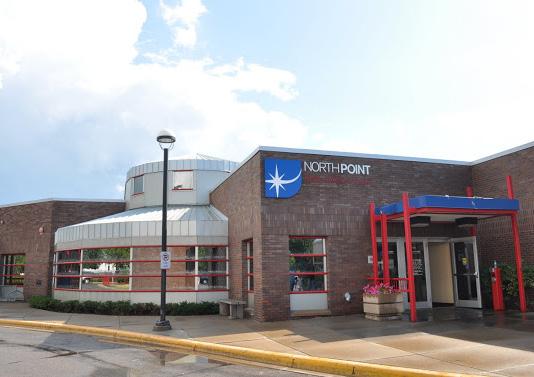


1 NorthPoint, Inc. Community-Based Development Concept

2 EXECUTIVE SUMMARY The NorthPoint Community Board Development concept is a community development strategy. It leverages NorthPoint s mission, "Partnering to Create a Healthier Community" into significant and strategic opportunities. Options include using the addition and redevelopment of the clinic building and site as a catalyst for development at the intersection of Penn & Plymouth Avenue and along both corridors. The NorthPoint project incorporates many of the principles of the Urban Land Institutes principles for building healthy places, including: Put people First, Mix it up, Promote Access to Healthy Food and Recognize the Economic Value. The project design builds on the increasing research and evidence that physical design effects human behavior at all scales- buildings, neighborhoods, communities, cities and regions. Where we live work and play can affect both our mental and physical well-being. By moving the parking facility to the SE corner of Penn and Plymouth Avenue, and combining it with retail/commercial, the project begins to address long-standing community needs. This move also allows the existing NorthPoint staff parking to be redeveloped (currently proposed as housing.) Most importantly, the concept frees the current NorthPoint site to allow for the replacement of the exisitng 6,000 sf Northpoint, Inc facility, and the additions of 6,000 sf expansion of much needed program space, and,000 sf of supportive circulation and common spaces. The proposed two story structure acknowledges the existing neighborhood grain and context while also creating a new address and destination in North Minneapolis. Concept Rendering


3 EXISTING SITE PROPERTY BOUNDRIES FOR NORTHPOINT HEALTH & WELLNESS 1TH AVE. N. 1TH AVE. N. NORTHPOINT INC. NORTHPOINT STAFF PARKING 6,000 S.F. NORTHPOINT HEALTH & WELLNESS CENTER 6,000 S.F. QUEEN AVE. ESTES FUNERAL HOME PENN AVE. URBAN LEAGUE OLIVER AVE. 6,0 S.F. PLYMOUTH AVE. NORTHPOINT SHORT TERM ADDITIONAL LEASED PARKING UNDEVELOPED UROC VACANT CPED LAND Aerial View Site Plan


4 CONCEPT PLAN 1th Avenue Security Fence Outdoor Patio with Canopy 1th Avenue Green Space EXISTING 6,000 SF 1 NorthPoint Health & Wellness Center Moderate Renovation of Existing 6,000 SF Required: Dental Clinic to remain and expand as required. Pharmacy to be relocated into new space. Medical Clinic to expand and relocate selected services. Lower Level Services relocated to new space - Lower Level to house limited program space Two-Story Addition with Lower Level: 0,000 SF Link to existing building Active Green Roof Relocated to allow for NPH&W expansion to Plymouth Ave SOUTH ADDITION 0,000 SF Patient Drop Off/ Pick-Up Lane Oliver Avenue FUTURE PRIVATE DEVELOPMENT URBAN LEAGUE MAIN ENTRY ESTES FUNERAL HOME Plymouth Avenue Signal at Intersection will be needed. TRANSIT ORIENTED DEVELOPMENT COMPONENT RETAIL 0,000 SF / PARKING 0 stalls 6 Oliver Avenue Parking Access NORTH ADDITION 0,000 SF Penn Avenue First Level will have two story Atrium/ Promenade along Penn with Second Level Link D Queen Avenue Northpoint, Inc. (current location) Northpoint, Inc. (property boundary) ay rivew Penn Avenue Two Story Addition - No Lower Level: Passive Green Roof URBAN RESEARCH & OUTREACH-ENGAGEMENT CENTER Property Acquisition Proposed Continuation of Oliver Avenue is desired.
5 SQUARE FOOT DATA BUILDING COMPONENT North-Point Health and Wellness Center Existing Building - North Addition LEVEL GROSS SQUARE FEET NOTES Lower Level,8 Moderate Renovation Required First Level, Moderate Renovation Required TOTAL EXISTING 6,0 First Level,000 No lower level, slab on grade Second Level,000 Includes second level link to south wing addition TOTAL 0,000 Lower Level 16,000 Includes link to existing lower level South Addition First Level 16,000 Includes main entry for the campus Second Level 16,000 Skyway connection at this level Third Level,00 Access to Green Roof TOTAL 0,000 TOTAL NEW CONSTRUCTION 100,000


6 COMPLETE STREETS Queen Avenue Green Space Driveway EXISTING 6,000 SF 1th Avenue ESTES FUNERAL HOME NORTH ADDITION 0,000 SF SOUTH ADDITION 8,000 SF BOUNDS OF COMPLETE STREETS COMPONENTS Penn Avenue 1th Avenue FUTURE PRIVATE DEVELOPMENT URBAN LEAGUE Plymouth Avenue RETAIL 0,000 SF / PARKING 0 stalls COMPLETE STREETS COMPONENTS INCLUDE: PEDESTRIAN LIGHTING, PLANTINGS, BIKE FACILITIES, SIDEWALK TREATMENTS & SIGNAGE Oliver Avenue Oliver Avenue UROC All capital improvement proposals regarding NorthPoint s expansion are being developed in alignment with the Penn Avenue Community Works (PACW) project. The synergies and potentials for partnership between the PACW project and the future expansion of NorthPoint are significant. Overlaps between the two efforts are being exploited fully as project proposals are developed. NorthPoint is one of the largest employers on the Penn Avenue corridor, and is located just north of the intersection of Penn and Plymouth Avenues in North Minneapolis, one of five commercial nodes identified by the PACW project as being focal points for future redevelopment opportunities along the corridor. The proposed Complete Streets improvements for the intersection of Penn and Plymouth Avenues included within this report, are as defined by the PACW project recommendations for all five of the key commercial 6 nodes along the Penn avenue corridor. The PACW project is currently assessing roadway layout and streetscape options, including green space, pedestrian lighting, signage, and the roadway layout itself. The extent of the proposed Complete Streets improvements included herein is as defined by the PAWC project recommendations. The Penn Avenue Community Works Corridor Vision and Implementation Framework will develop an integrated communitybased vision and a coordinated, longterm implementation framework for the Penn Avenue corridor. The outcomes of this community development planning and design effort will guide future inter-agency efforts and investments in multimodal transportation, land use, economic development, housing, and place making as part of Penn Avenue Community Works (PACW). Recommendations that come out of the PACW project will be integrated into the expansion of NorthPoint as both project progress. The PACW project is looking at opportunities to leverage Metro Transit s planned C Line Bus Rapid Transit, scheduled to be operational in December 016. The goals, objectives, and priorities of Penn Avenue Community Works will be refined through ongoing community engagement and subsequent phases of this project. Working objectives established for the Penn Avenue Community Works project include: Re-envision Penn Avenue as a complete street with enhanced transit service, pedestrian amenities, bicycle connections, and environmentally sustainable streetscaping Stimulate private investment and promote economic opportunity in the corridor by improving public infrastructure and through targeted housing, redevelopment and economic development strategies Enhance livability in the corridor by improving public spaces, connections to key destinations, and through other placemaking strategies. The study findings and community input PACW has collected through its community engagement efforts support increased development at the node of Penn and Plymouth Avenues, including Northpoint s expansion and a parking structure. The specific NorthPoint Community Board Development Concept proposed in this report is not a concept specifically supported by PACW, but increased development and density at this intersection, in general, is supported by PACW. 6
7 ADVANTAGES RISKS 1. Brings physical presence to NorthPoint s mission of Partnering to Create a Healthier Community.. The community development aspect of the project addresses the social determinants of health and leverages development over broader area, serving as a catalyst for other developments at this key North Minneapolis node.. Supports complimentary uses and existing, proposed, and potential future development at Penn / Plymouth.. Offers joint-use potentials for parking with institutional neighbors, further reducing impacts on neighborhood.. Creates a dynamic place in North Minneapolis and brings a strong NorthPoint presence to the high-visibility Penn / Plymouth intersection. 6. Offers more convenient drop-off functionality for patients and clients of NorthPoint.. NorthPoint internal circulation will be more intuitive for patients and visitors. 8. Fills up key corner sites at this major intersection, making a strong statement about North Minneapolis future. 9. The resulting NorthPoint building is lower (two stories above grade plus green roof spaces) and less obtrusive in the neighborhood context. 10. Parking is directly adjacent to, and therefore affects, very few residences. 11. Dispersed program elements will allow easier construction phasing (open space for yarding, etc.). 1. Development spread over these sites fits comfortably with upcoming changes to Penn and Plymouth Avenues set in motion by Penn Avenue Community Works efforts (Complete Streets, BRT Transit, etc.). 1. Will not require remote relocation of NorthPoint staff and patient parking during construction construction phasing will allow present facilities to remain in use until new facilities are finished. 1. With multiple owners controlling subject sites (County, City, Private Owners), this concept may require extended time for negotiation prior to construction.. Multiple ownership also will also bring unpredictability in acquisition costs.. Logistics of Estes and future retail/commercial construction may extend timeline for construction.. Design of parking with adjoining building(s) may be complex.. Present NorthPoint parking lot (east of Penn) recast as future private development site success depends on finding developer with appropriate project, which could take time. 6. This concept requires a more extensive renovation of existing NorthPoint building due to broader intersection/ interface, including much of the existing dental clinic. Modifications to the existing medical clinic are also complicated in this scheme,which either splits the medical clinic in two areas or moves it completely from its current location.. Private green space on Queen / 1th Avenues will need secure perimeter. 8. More extensive building perimeter and roof add additional cost. 9. Costs reflect order of magnitude construction values, but are subject to property negotiations. 10. In recent months, construction pricing has been very volatile, with significant upward trending. The several project components and the span of time necessary to complete them may mean that project costs are difficult to predict with accuracy.
8 PARKING CONCEPT - ELEVATIONS URBAN LEAGUE RETAIL AND PARKING RETAIL PARKING CONCEPT - 1 LOWER LEVEL LOWER LEVEL 1 # OF SPACES 9 LOWER LEVEL 1 9 LOWER LEVEL 88 1ST LEVEL 88 ND LEVEL 88 RD LEVEL 9 TOTAL 0 1ST LEVEL ND LEVEL RD LEVEL NorthPoint Community-Board Development Concept 1.0.1
9 NorthPoint Health & Wellness Center NorthPoint, Inc. Community-based Development Concept Order of Magnitude / Project Cost Matrix Facility Services Hennepin County Public Works Identification & Ownership May 0 01 DRAFT EXISTING PARCEL INFORMATION 1 NP Main Site NP, Inc. Site Estes Property SW Penn & Plymouth SE Penn & Plymouth 6 Residential Lot S. of SE corner NP East Parking Lot County N.P., Inc. Private City City Private County Totals Acreage. (98,881 SF) 0.6 (, SF) 0.6 (,106 SF) 0.9 (0,96 SF) 1. (66,6 SF) 0.6 (11,6 SF) 1. (8,0 SF). (6,19 SF) Building GSF 6,000 6,000 9,00 N / A N / A,00,00 109,00 Parking Stalls N / A N / A 11 USES - Component Costs per Parcel SOURCES - Partners / Funding Unit Components OVERALL DEVELOPMENT 1 NP Main Site NP, Inc. Site Estes Property SW Penn & Plymouth SE Penn & Plymouth 6 Residential Lot S. of SE corner NP East Parking Lot County N.P., Inc. Private City City Private County Hennepin Co. Penn Avenue Community Works NorthPoint, Inc. -New Market Tax Credits -Capital Campaign Estes Funeral Home County Admin direction needed on funding source Retail Space?? : $1.0 /SF A - Land Acquisition 6: $11.0 /SF Key Note A. $00,000 $0,000 $1,00 $,000 $10,000 $00,000 $16 / SF Varies by site B - Bldg. Demolition $1,000,000 $00,000 $0,000 $110,000 Not Applicable $0,000 1-:$10.66 /SF &6: $.8/SF C - Site Development $,000,000 D - NP Facility 100,000 GSF $60 per GSF $6,000,000 Addition North & South E - Remodel Existing NP $00 per USF Health & Wellness Center $K per Stall $106 per GSF $1.10 / SF $18 per GSF F - Parking Structure (Concept 1) 0 Stalls G - Shell Retail Space in Parking Structure 0,000 SF H - Estes Funeral Home Site Development I - Estes Funeral Home Construction 9,00 SF See Estes below $1,00,000 $00,000 (Component H) See Key Note B. See Key Note G. $800,000 See Key Note G. $1,600,000 See Key Note G. $9,000,000 $,000,000 $,000,000 $,000,000 $1,900,000 $16K / LF J - Skyway 0 LF $,00,000 $6,000,000 See Key Note C. $1,900,000 of 0 stalls $11,00,000 See Key Note F. $00,000 See Key Note F. $00,000 See Key Note F. $,000,000 of 0 stalls $,00,000 0 of 0 stalls $900,000 Key Note E. $,00,000 $,00,000 $,00,000 $00,000 $00,000 $00,000 $1,00,000 $1,00,000 $1,00,000 Lump Sum $0 / LF of streetscape K - Street Signalization Plymouth & Oliver Aves. L - Complete Streets by Penn Ave. Community Works Total Costs: $00,000 $00,000 $00,000 $00,000 $00,000 See Key Note D. $00,000 $66,000,000 $8,900,000 $00,000 $10,100,000 $,00,000 $,100,000 General Notes: Key Notes: 1. All costs have been calculated in today's dollars and do not include escalation.. Future transit hubs proposed for this intersection are by Metro Transit, and not included in this project's scope.. Costs for City-owned land & skyways have been removed. A. Land assumed to be contributed by the City of Minneapolis. B. No Demo Costs. This lot to be left as is for future sale & private development. C. The cost per stall is lower on this site than if the ramp were to be developed on parcel. That is due to the shape of the ramp footprint, less residential exposure & proximity to commercial neighbors, & site grades. D. The order of magnitude cost for the Complete Streets component was provided by the Penn Avenue Community Works project team, with consultant Hoisington Koegler Group. They provided a cost consistent with some of their recent streetscape work and construction bid tabs. The LF cost represents roughly 10' streetscape zones on either side of the street, ' concrete sidewalks, street trees at approximately 0' spacing, ' tree lawns (sod) between the curb and the sidewalk, pedestrian lamps (spaced 60'- 80' apart) and amenities at the intersections (trash receptacles, seating, bike racks). E. 0 stalls designated for retail use. Up to 60 stalls to be shared during NorthPoint's off-peak hours. F. NorthPoint, Inc. is assumed to be responsible for 18.% of cost components B, C and D. NorthPoint, Inc's program calls for 18.% of the proposed new construction square foot area (including the area for non-profit partners under their umbrella.) G. NorthPoint Health & Wellness is assumed to be responsible for 81.% of the new construction.
Chapter 1: Introduction
 Chapter 1: Introduction The Penn Avenue Community Works Corridor Vision and Implementation Framework presents an integrated communitybased vision and a coordinated, long-term implementation framework for
Existing Conditions. Planning and Design Principles
 penn s south bank enn s South Bank is located south of the Schuylkill River at the intersection of 4th Street and. This acre former heavy industrial site offers the opportunity to accommodate a variety
Corridor Vision. 1Pursue Minnehaha-Hiawatha Community Works Project. Mission of Hennepin County Community Works Program
 1Pursue Minnehaha-Hiawatha Community Works Project Minnehaha-Hiawatha Community Works is a project within the Hennepin Community Works (HCW) program. The mission of the HCW program is to enhance how the
Mary Hills Nature Area. Roadway Lighting. The Minneapolis Clinic of Neurology Courage Kenny Rehabilitation Institute
 PUBLIC REALM IMPROVEMENTS Mary Hills Nature Area Enhanced Programming Glenview Terrace Valley View Roadway Lighting Enhanced Streetscape Trail Lighting / Roadway Lighting Wayfinding Public Art The Minneapolis
Gold Line Bus Rapid Transit Transit Oriented Development (BRTOD) Helmo Station Area Plan
 Helmo Station Area Plan") Appendix F Gold Line Bus Rapid Transit Transit Oriented Development (BRTOD) Helmo Station Area Plan Introduction and Purpose of the Plan The Gold Line Bus Rapid Transit facility is an eleven-mile dedicated
Appendix F Gold Line Bus Rapid Transit Transit Oriented Development (BRTOD) Helmo Station Area Plan Introduction and Purpose of the Plan The Gold Line Bus Rapid Transit facility is an eleven-mile dedicated
ROBBINSDALE LRT STATION CDI DEVELOPMENT GUIDELINES
 August 2018 OVERVIEW The City of Robbinsdale has a prime-opportunity site in the middle of the 13 mile stretch of the Bottineau LRT corridor / Blue Line extension. Robbinsdale offers a prominent, vital,
Scope of Services. River Oaks Boulevard (SH 183) Corridor Master Plan
 Corridor Master Plan") Scope of Services River Oaks Boulevard (SH 183) Corridor Master Plan PROJECT AREA The project area consists of the River Oaks Boulevard (SH 183) corridor bounded by SH 199 at the northern end and the Trinity
Scope of Services River Oaks Boulevard (SH 183) Corridor Master Plan PROJECT AREA The project area consists of the River Oaks Boulevard (SH 183) corridor bounded by SH 199 at the northern end and the Trinity
Urban Planning and Land Use
 Urban Planning and Land Use 701 North 7 th Street, Room 423 Phone: (913) 573-5750 Kansas City, Kansas 66101 Fax: (913) 573-5796 Email: planninginfo@wycokck.org www.wycokck.org/planning To: From: City Planning
Transportation. Strategies for Action
 Transportation A major priority for the Overlake Neighborhood is to develop a multimodal transportation system. To achieve this system, a balance has to be found among travel, circulation and access needs;
The West College Avenue Corridor Redevelopment Plan
 The West College Avenue Corridor Redevelopment Plan Proposed dby Educational Property Group, Inc. & Apex Development Project Summary The intent of this proposal is to introduce market-driven mixed-use
Robbinsdale LRT Station. CDI Development Guidelines. August Overview
 Robbinsdale LRT Station August 2018 Overview The City of Robbinsdale may have the coolest opportunity site along the 13 mile stretch of the Bottineau LRT corridor / Blue Line extension. Located a block
3. VISION AND GOALS. Vision Statement. Goals, Objectives and Policies
 Vision Statement Queen Creek s interconnected network of parks, trails, open spaces and recreation opportunities provide safe and diverse activities and programs that sustain its unique, small town, equestrian
This Review Is Divided Into Two Phases:
 Semiahmoo Town Centre Review The purpose of this review: To review the Semiahmoo Town Centre Concept Plan, originally approved in 1993, to ensure that this centre will continue to serve the needs of South
Midtown Greenway Land Use and Development Plan Executive Summary
 Midtown Greenway Land Use and Development Plan Executive Summary Introduction The Midtown Greenway Land Use and Development Plan sets policy direction for land use and development in the Midtown Greenway
BROOKLYN PARK / 85TH AVE LRT STATION CDI DEVELOPMENT GUIDELINES DRAFT
 August 2018 Page intentionally left blank The Brooklyn Park Library adjacent to the 85th Ave LRT Station Area. OVERVIEW The Blue Line LRT Extension / Bottineau corridor offers a unique opportunity to leverage
THE TOWN OF WASAGA BEACH
 THE TOWN OF WASAGA BEACH Downtown Development Master Plan Committee of the Whole Presentation January 26 th 2017 Uses within this designation should reflect a dependence on tourism as opposed to the permanent
LUNDY S LANE COMMUNITY IMPROVEMENT PLAN STUDY
 PUBLIC INFORMATION MEETING #2 October 12, 2016 LUNDY S LANE COMMUNITY IMPROVEMENT PLAN STUDY AGENDA 5:00 to 5:30pm: Open House 5:30 to 6:15pm: Presentation 6:15 to 7:00pm: Individual paced workshop with
Institutional Overlay Zone (IOZ) Regulatory Framework
 Regulatory Framework") Institutional Overlay Zone (IOZ) Regulatory Framework Approved by Portland City Council November 20, 2017 APPLICABILITY All development proposed by Maine Medical Center (MMC) within the boundary of the
Institutional Overlay Zone (IOZ) Regulatory Framework Approved by Portland City Council November 20, 2017 APPLICABILITY All development proposed by Maine Medical Center (MMC) within the boundary of the
ELK GROVE GENERAL PLAN VISION
 2-1 CHAPTER 2: 2-2 CREATING OUR The Community Vision for Elk Grove, expressed through a Vision Statement and a series of Supporting Principles, is a declaration of the kind of community that Elk Grove
Corridor Background. Defining the Corridor Study Area. Lake Street. 38th Street. 46th Street
 1 Corridor Background Defining the Corridor Study Area Minnehaha Avenue (CSAH 48) and Hiawatha Avenue (MN 55) are parallel diagonal roadways, approximately three blocks apart, that provide two direct arterial
ANC 2A Presentation. November 9, 2006
 ANC 2A Presentation November 9, 2006 Introduction & Overview Applicants Boston Properties and KSI Services (project developers) The George Washington University (land owner) 2.66 acre site (former GW hospital
DRAFT. 10% Common Open Space
 % OF CHARLOTTE IS CATEGORIZED AS A. LAND USES : Placeholder map displaying location of Place Type GOALS: Accommodate XX% of future growth. Provide a concentration of primarily commercial and civic activity
Study Area. Capitol Way. Greening America s Capitals 11/13/2014. A Greening America s Capitals Project
 Olympia, WA: Greening Capitol Way Supporting Communities move towards sustainability is a priority for the federal government. A Greening America s Capitals Project Office of Sustainable Communities U.S.
Implementation Guide Comprehensive Plan City of Allen
 Implementation Guide 2030 Comprehensive Plan City of Allen DRAFT 2015 Implementation Guide Allen 2030 Comprehensive Plan INTRODUCTION The Comprehensive Plan serves as a guide for the growth and development
Chapter 1.0 Introduction
 Chapter 1.0 Introduction 1.1 Background The North Metro commuter rail line is part of the RTD FasTracks regional transit system expansion program to build more than 100 miles of rail transit throughout
Rio/29 Small Area Plan. Design Plan & Implementation Framework Open House - January 25, 2018
 Rio/29 Small Area Plan Design Plan & Implementation Framework Open House - January 25, 2018 MEETING PURPOSE PRESENTATION 1. Orient to the updated design plans 2. Introduce implementing options 3. Explain
Urban Design. in the City of Kitchener. MUDR Presentation May 2010
 Urban Design in the City of Kitchener MUDR Presentation May 2010 Highlights Direction: long term commitment to urban design in Kitchener Themes: density, mixed use, community focal points, transit, accessibility
Shift Rapid Transit Public Participation Meeting May 3, 2017
 Shift Rapid Transit Public Participation Meeting May 3, 2017 Shift Rapid Transit Initiative Largest infrastructure project in the city s history. Rapid Transit initiative will transform London s public
Town Center (part of the Comprehensive Plan)
") Town Center (part of the Comprehensive Plan) Mercer Island Town Center Looking North (2014) In 1994, a year-long process culminated in a set of design guidelines and code requirements for the Town Center
Town Center (part of the Comprehensive Plan) Mercer Island Town Center Looking North (2014) In 1994, a year-long process culminated in a set of design guidelines and code requirements for the Town Center
LEED-ND 101: Practical Strategies for Achieving Sustainability Goals. Travis Parker Lakewood Planning Director
 LEED-ND 101: Practical Strategies for Achieving Sustainability Goals Travis Parker Lakewood Planning Director Metro Vision Idea Exchange Oct 11, 2012 West Corridor Stations West Corridor Overview West
The University District envisions, in its neighborhood
 Envisioning the University District Link Light Rail in Seattle s neighborhoods CIY OF SEALE CONCEP-LEVEL SAION AREA PLANNING RECOMMENDAION RESOLUION # 30165 EXHIBI L Vision 08.2000 he University District
PLAN ELEMENTS WORKSHOP. April 5, 2016
 PLAN ELEMENTS WORKSHOP April 5, 2016 needs more housing. But there is no one-size fits-all solution. Every neighborhood has its own character. In some places, density is not only appropriate it is badly
Urban Design Manual PLANNING AROUND RAPID TRANSIT STATIONS (PARTS) Introduction. Station Study Areas
 Introduction. Station Study Areas") 111111 PLANNING AROUND RAPID TRANSIT STATIONS (PARTS) Introduction The ION rapid transit system will link Waterloo, Kitchener and Cambridge through a central transit corridor (CTC). There are a number
111111 PLANNING AROUND RAPID TRANSIT STATIONS (PARTS) Introduction The ION rapid transit system will link Waterloo, Kitchener and Cambridge through a central transit corridor (CTC). There are a number
ASPEN HILL Minor Master Plan Amendment
 ASPEN HILL Minor Master Plan Amendment Project Briefing Planning Board Agenda Item #7 Andrea Gilles, Area 2 June 5, 2014 Briefing Purpose 1. Follow-up evaluation on Mixed-Use land use in the Minor Amendment
UAA School of Engineering Parking Garage Master Plan Amendment. 1. Purpose
 UAA School of Engineering Parking Garage Master Plan Amendment 1. Purpose Since the UAA campus master plan was drafted in 2003, adopted in 2004, and amended in 2009 a number of significant changes regarding
IMPLEMENTING SOMERSET COUNTY S INVESTMENT FRAMEWORK
 IMPLEMENTING SOMERSET COUNTY S INVESTMENT FRAMEWORK SMART CONSERVATION THROUGH SMART GROWTH NJ LAND CONSERVATION RALLY March 22, 2014 Laurette Kratina, PP, AICP, Supervising Planner Somerset County Planning
The principal elements of the NTC Strategic Vision plan are as follows.
 The proposed project would improve the NTC site plan, circulation, visitor amenities, and landscaping, and would include construction of two new stadiums to replace the existing Louis Armstrong Stadium
Ivywild On The Creek PRELIMINARY CREEK DISTRICT MASTER PLAN
 Ivywild On The Creek PRELIMINARY CREEK DISTRICT MASTER PLAN Introduction: Rejuvenating an extraordinary Creekside neighborhood THE CREEKSIDE DISTRICT The Ivywild On The Creek Neighborhood District Master
Public may provide comments on the GDP within the next two weeks (December 24)
") 25/70 General Development Plan (GDP) Public Meeting Wednesday, December 10, 2014 6:00 8:00 P.M. District 1 Police Station Community Room 1311 W 46th Ave, Denver, CO 80211 Council Woman Montero: This particular
25/70 General Development Plan (GDP) Public Meeting Wednesday, December 10, 2014 6:00 8:00 P.M. District 1 Police Station Community Room 1311 W 46th Ave, Denver, CO 80211 Council Woman Montero: This particular
V. Vision and Guiding Principles
 V. Vision and Guiding Principles The Master Plan for the Powers Ferry Corridor seeks a foundation in the desires of the community. At times, various elements of the community offered opposing viewpoints,
ULI St. Louis Technical Assistance Panel
 ULI St. Louis Technical Assistance Panel ULI St. Louis Technical Assistance Panel Sponsored by: Citizens for Modern Transit in partnership with METRO ULI St. Louis Mission Statement The mission of the
Cobb County Design Guidelines Mableton Parkway & Veterans Memorial Highway Community Design Workshop January 12, 2017
 Community Design Workshop January 12, 2017 Agenda Opening Remarks / Introductions Scope of Work Existing Conditions Key Issues / Opportunities VPS Summary Draft Vision & Goal Statement Implementation Concepts
Westwind Developments Ltd. PIONEER LANDS AREA STRUCTURE PLAN - PROPOSED AMENDMENT
 FEBRUARY 2013 TABLE OF CONTENTS 1.0 BACKGROUND... 1 1.1 Amendment... 1 2.0 LOCATION & CONTEXT... 2 2.1 Land Ownership... 2 3.0 POLICY CONTEXT... 3 3.1 Municipal Development Plan... 3 3.2 Capital Region
CITY OF FARGO PARKING RAMP SITE EVALUATION
 CITY OF FARGO PARKING RAMP SITE EVALUATION EXECUTIVE SUMMARY Helenske Design Group (architect) and Carl Walker Inc (Parking Consultant) were retained by the City of Fargo to complete a downtown parking
City of Bristol Route 6 Corridor Implementation Program
 City of Bristol Route 6 Corridor Implementation Program FITZGERALD & HALLIDAY, INC. Innovative Planning, Better Communities June 2017 Route 6 Corridor Plan IMPLEMENTATION PROGRAM The following Implementation
John M. Fleming Managing Director, Planning and City Planner. Old East Village Dundas Street Corridor Secondary Plan Draft Terms of Reference
 Report to Planning and Environment Committee To: From: Subject: Chair and Members Planning & Environment Committee John M. Fleming Managing Director, Planning and City Planner Old East Village Dundas Street
Route 1 Corridor Study
 Route 1 Corridor Study Westbrook, Connecticut A Vision for the Connecticut Shoreline Public Informational Meeting July 28, 2015 Lower Connecticut River Valley Council of Governments Fitzgerald & Halliday,
Developer s Program. The Station at East 54
 Developer s Program The Station at East 54 Existing Conditions The Station at East 54 is proposed for a 1.12 acre site at the northeast corner of Hamilton Road and Prestwick Road, tucked between the East
University of Minnesota. MINNEAPOLIS CAMPUS DEVELOPMENT FRAMEWORK February 11, 2016
 MINNEAPOLIS CAMPUS DEVELOPMENT FRAMEWORK DEVELOPMENT FRAMEWORK of use shape the campus today and may inform the future. Form, meaning how the shape, size, orientation, and arrangement of buildings, spaces,
Silverdale Regional Center
 Silverdale Regional Center Vision for Silverdale Regional Center The Silverdale Regional Center Plan (Plan) will guide the evolution of the Silverdale Regional Center from a collection of strip malls and
THE NEIGHBORHOOD TODAY
 THE NEIGHBORHOOD TODAY CORE AREA VISION How are we Good Urbanism A Site s DNA thinking about Elements of great Unique elements urban communities embedded in a place the site and design? ELEMENTS LIKE:
Port Credit Local Advisory Panel October 20 th Meeting
 Port Credit Local Advisory Panel October 20 th Meeting Focus Of This Evening s Meeting: 1. Hurontario Main Street Higher Order Transit Study 2. Port Credit Mobility Hub & GO Station Parking Structure Study
Goal 1: To Encourage the Orderly, Harmonious and Judicious Use of University Resources in the Development of University Land.
 2.0 Future Land Use Goal 1: To Encourage the Orderly, Harmonious and Judicious Use of University Resources in the Development of University Land. Objective 1.1: Make available future building sites that
2030 Comprehensive Plan VISION STATEMENT
 RESOURCE DOCUMENT for Steering Committee Meeting #2 July 12, 2017 2030 Comprehensive Plan VISION STATEMENT Steering Committee from 2008 Established the Lauderdale s Vision as: Creating a livable, lovable
North Fair Oaks Community Plan Summary and Information
 North Fair Oaks Community Plan Summary and Information WHAT IS THE NORTH FAIR OAKS COMMUNITY PLAN? The North Fair Oaks Community Plan is part of the San Mateo County General Plan, and establishes policies
Clairtrell Area Context Plan
 Clairtrell Area Context Plan March 2005 Urban Development Services City Planning Contents 1. Introduction... 4 2. Development Structure... 6 2.1 Streets... 7 2.1.1 Sheppard Avenue and Bayview Avenue...
New Partners for Smart Growth Conference February 5, 2010
 Dan Stroh, Planning Director City of Bellevue Planning and Community Development Bellevue, WA New Partners for Smart Growth Conference February 5, 2010 Summary of Project Long-range plan update for Bel-Red
South Davis County COMMUNITY SPOTLIGHT
 South Davis County COMMUNITY SPOTLIGHT Davis/SLC Community Connector Bus Rapid Transit line connecting SLC & Davis County RTP Phase 1 Project Generate 3,100 average weekday riders Relieve congestion on
3. Endorse the LRT vision in transforming Surrey into Connected-Complete-Livable communities, and more specifically, the official vision statement:
 CORPORATE REPORT NO: R038 COUNCIL DATE: February 20, 2017 REGULAR COUNCIL TO: Mayor & Council DATE: February 16, 2017 FROM: General Manager, Engineering FILE: 8740-01 SUBJECT: Surrey Light Rail Transit
Derry Green Corporate Business Park
 Town of Milton Derry Green Corporate Business Park Urban Design Guidelines BMI/Pace - June 2010 Draft 3 Prepared by: Brook McIlroy Planning + Urban Design / Pace Architects Suite 300-51 Camden Street Toronto,
1.0 VISION STATEMENT. December 6, PRINCIPLES
 Vision Statement Lincoln Regional Airport 1.0 VISION STATEMENT 1.1 City LOCATION of AND OVERVIEW The Easton Lincoln Place Land Use Master Plan identifies the principles, goals, policies, and standards
Building out the Regional Growth Strategy in Surrey: a Strong Centre & a Connected Transit City
 Building out the Regional Growth Strategy in Surrey: a Strong Centre & a Connected Transit City Surrey in the Metro Vancouver Region Regional Growth Strategy identifies Surrey as a major provider of housing
Corridors. Re-vitalize our Corridors and Gateways
 Corridors Re-vitalize our Corridors and Gateways Artist s rendering from the 287 Strategic Plan, 2015 Corridors are the major throughways of Loveland but they also provide important commercial, community
The transportation system in a community is an
 7 TRANSPORTATION The transportation system in a community is an important factor contributing to the quality of life of the residents. Without a sound transportation system to bring both goods and patrons
PUBLIC OPEN HOUSE HURONTARIO-MAIN CORRIDOR SECONDARY PLAN
 PUBLIC OPEN HOUSE HURONTARIO-MAIN CORRIDOR SECONDARY PLAN Tuesday, February 28, 2012 6pm 9pm 1 st Floor Atrium, City Hall 2 Wellington Street West, Brampton 1 POLICY FRAMEWORK The 2006 Provincial Growth
Staff Report and Recommendation
 Community Planning and Development Planning Services 201 W. Colfax Ave., Dept. 205 Denver, CO 80202 p: 720.865.2915 f: 720.865.3052 www.denvergov.org/cpd TO: City Council Neighborhoods and Planning Committee
A BLUEPRINT FOR BROCKTON A CITY-WIDE COMPREHENSIVE PLAN
 A BLUEPRINT FOR BROCKTON A CITY-WIDE COMPREHENSIVE PLAN Public Meeting October 2016 1 Plan Summary and Discussion Public Meeting May 4 2017 City of Brockton Bill Carpenter, Mayor Department of Planning
Hopkins. Development Guidelines May Overview. Sponsored by: Blake Road Corridor Collaborative City of Hopkins
 Hopkins Blake Road LRT Station Area Development Guidelines May 2015 Sponsored by: Blake Road Corridor Collaborative City of Hopkins Overview Hopkins is a dynamic community of over 17,000 residents located
Planning Districts INTRODUCTION
 INTRODUCTION To facilitate detailed examination of development prospects for all areas of the community, Delano has been divided into 14 planning districts. The location of these planning districts is
Create Policy Options Draft Plan Plan Approval. Public Consultation Events. Phase 2
 Background Grandview-Woodland Community Plan In the spring of 2012, the City of Vancouver embarked on a comprehensive community planning program in the Grandview-Woodland neighbourhood. The process has
38 Queen s University Campus Master Plan Part 1
 38 Queen s University Campus Master Plan Part 1 46 The Campus at the City Scale Chapter 4 The Campus at the City Scale 39 Queen s is an urban University centrally located in Kingston. Decisions made by
TOD 101 CREATING LIVABLE COMMUNITIES WITH TRANSIT
 1 CREATING LIVABLE COMMUNITIES WITH TRANSIT What are transit Centered Communities? Benefits of Partnerships to Support and Implement What You Will Learn Portland s Pearl District Your Trainers Today Catherine
Town of Oakville Streetscape Strategy
 Town of Oakville Streetscape Strategy Endorsed by PDC on February 10, 2014 (PD-011-14) Town of Oakville Streetscape Strategy [endorsed by PDC February 10, 2014] 0 Town of Oakville Streetscape Strategy
Table of Contents. Elm Avenue Improvement Plan City of Waco, Texas. Introduction 1. Existing Context 1 Figure 1 2.
 Table of Contents Introduction 1 Existing Context 1 Figure 1 2 Plan Guidelines 3 Future Urban Form 4 The West-End 4 Main Street 6 The East-End 7 Figure 2 9 Public Improvement Recommendations 7 General
SW Ecodistrict A VISION PLAN FOR A MORE SUSTAINABLE FUTURE June 25, 2013
 Urban Land Institute The Past, Present and Future of Sustainable Urbanism in Southwest DC SW Ecodistrict A VISION PLAN FOR A MORE SUSTAINABLE FUTURE June 25, 2013 Study Area The National Mall DOE FAA FAA
IMAGINE CLEARWATER. Community Workshop 3. November 2016
 IMAGINE CLEARWATER Community Workshop 3 November 2016 Imagine Clearwater has been a 6-month community-focused process to re-envision the downtown waterfront. VISIONING FRAMEWORK MASTER PLAN HOW CAN WE
Plano Tomorrow Vision and Policies
 Plano Tomorrow Vision and Policies PLANO TOMORROW PILLARS The Built Environment The Social Environment The Natural Environment The Economic Environment Land Use and Urban Design Transportation Housing
2040 LUP is a part of the Comprehensive Plan and carries the same legal authority. Economic Challenges
 1.1. Guiding Anchorage s Growth Where will new residents settle over the next two decades? Where will people work, shop, and play? Will there be enough room to grow? How will Anchorage look? Will growth
EXISTING COMPREHENSIVE PLAN
 EXISTING COMPREHENSIVE PLAN Town Center Land Use Element: V. LAND USE POLICIES Town Center Mercer Island's business district vision as described in "Your Mercer Island Citizen-Designed Downtown" was an
MONTGOMERY COUNTY METRO STATION AREA DESIGN CHARRETTE
 MONTGOMERY COUNTY METRO STATION AREA DESIGN CHARRETTE Shady Grove Metro Station Area Charrette Closing Presentation October 25-28, 2000 MONTGOMERY COUNTY, MD M-NCPPC Design Collective, Inc. Architects
University of the District of Columbia Van Ness Campus Master Plan Community Open House 3. December 8, 2010
 University of the District of Columbia Van Ness Campus Master Plan Open House 3 December 8, 2010 Introductions Sequence of Work: Campus Master Plan BEGIN: INTRODUCE AND START WORK Project Initiation Team
UCSF Parnassus Heights Re-Envisioning Process
 UCSF Parnassus Heights Re-Envisioning Process Community Working Group Meeting #5 February 27, 2019 Agenda Welcome, Introductions, Agenda Overview, and Review of Last Meeting Summary of Community Ideas
Blue Line LRT Extension
 v e Noble Pkwy Noble Pkwy Xerxes Ave N Shingle Creek Penn Ave N Penn Ave N Fremont Ave N Lyndale Ave N S Washington Ave University Ave NE Blue Line LRT Extension LIGHT RAIL PLATFORM AND STATION DESIGN
Sahuarita District & Phase 1 Master Plan. Town Council December 11, 2017
 Sahuarita District & Phase 1 Master Plan Town Council December 11, 2017 Visioning Study Visioning Process Advisory Group Meetings Community Questionnaire Town Center Case Studies Community Analysis The
Atlanta BeltLine. Subareas 9 & 10. Master Plan Updates. March 26, Washington Park Jamboree 1
 Atlanta BeltLine Subareas 9 & 10 Master Plan Updates March 26, 2018 Washington Park Jamboree 1 22 miles, connecting 45 neighborhoods 22 MILES of transit 46 MILES of streetscapes and complete streets 33
DRAFT. October Wheaton. Design Guidelines
 October 2011 DRAFT Wheaton Design Guidelines 2 Draft - Design Guidelines - Wheaton Sector Plan Contents 04 Section 1: Introduction 06 Section 2: Context 08 Section 3: Design Guidelines 09 Goal 1: Create
CITY OF CHARLOTTESVILLE, VIRGINIA CITY COUNCIL AGENDA
 CITY OF CHARLOTTESVILLE, VIRGINIA CITY COUNCIL AGENDA Agenda Date: December 16, 2013 Action Required: Adoption of Resolution Presenter: Staff Contacts: Title: James E. Tolbert, AICP, Director of NDS James
The Five Components of the McLoughlin Area Plan
 The Five Components of the McLoughlin Area Plan This documents contains the complete language of the five components of the McLoughlin Area Plan: The Vision Statement The Values The Guiding Principles
DRAFT City of Titusville 2040 Comprehensive Plan Future Land Use, Housing, and Transportation Elements April 16, 2018
 DRAFT City of Titusville 2040 Comprehensive Plan Future Land Use, Housing, and Transportation Elements April 16, 2018 Prepared by Canin Associates for the City of Titusville About the Comprehensive Plan:
BUILDING SCALE AND SETBACKS 5 ELEMENTS:... 5 FAÇADES (COMMERCIAL/RESIDENTIAL) 5
 5") VISION STATEMENT 3 UTILIZATION OF THE GUIDELINES 3 IMPLEMENTATION 3 PROCEDURES FOR DESIGN REVIEW 3 LAND USE AND ZONING 4 LAND USE 4 ELEMENTS:... 4 ZONING 4 ELEMENTS:... 4 BUILDING SCALE AND SETBACKS 5
VISION STATEMENT 3 UTILIZATION OF THE GUIDELINES 3 IMPLEMENTATION 3 PROCEDURES FOR DESIGN REVIEW 3 LAND USE AND ZONING 4 LAND USE 4 ELEMENTS:... 4 ZONING 4 ELEMENTS:... 4 BUILDING SCALE AND SETBACKS 5
CITY OF PUYALLUP. Background. Development Services
 CITY OF PUYALLUP Development Services 333 South Meridian Puyallup WA 98371 To: City Council From: Katie Baker, AICP, Planning Division Re: South Hill Neighborhood Plan Adoption Date: (Meeting date: February
MALL REVITALIZATION CASE STUDIES
 MALL REVITALIZATION CASE STUDIES DECEMBER 9, 2012 MALL REVITALIZATION OVERVIEW Introduction Sample Case Studies prepared for Lacey Woodland District Steering Committee as it considers strategies to revitalize
The Vision. Photo provided by The Minervini Group. 46 Vision, Objectives & Strategies
 Vision, Objectives & Strategies The is the public framework and guide for future development of the Grand Traverse Commons. The establishes public polices for infrastructure, the preservation of natural
Tyvola & Archdale Transit Station Area Plan. June 5, 2008
 Tyvola & Archdale Transit Station Area Plan Second Public Meeting June 5, 2008 Presentation Outline 1. Purpose and Process 2. Station Area Overview 3. Plan Recommendations 4. Comments Received and Proposed
Denver Moves: Transit Task Force
 Insert transit picture Denver Moves: Transit Task Force Meeting #8 October 5, 2017 1. Welcome & Introductions Opening remarks and housekeeping Task Force and audience introductions Upcoming events and
Independence Boulevard Area Plan Planning Committee Public Comment May 18, 2010
 Independence Boulevard Area Plan Planning Committee Public Comment May 18, 2010 Presentation Outline Focus on Key Recommendations within Draft Plan Plan Purpose and Development Process Draft Plan Policies
SCARBOROUGH SUBWAY EXTENSION. Scarborough Subway Extension. Final Terms of Reference
 Scarborough Subway Extension Final Terms of Reference 1 1.0 Introduction and Background 1.1 Introduction Toronto City Council recently confirmed support for an extension of the Bloor-Danforth Subway from
Economic Development & Housing Council Committee Comprehensive Plan Update September 20, 2005
 1 Economic Development & Housing Council Committee Comprehensive Plan Update September 20, 2005 Purpose To update the Committee on the ForwardDallas! Plan, including: Status Anticipated Products Public
8implementation. strategies
 PROGRAM STRATEGIES 8implementation strategies T he implementation actions of this chapter are designed to support and carry out the land use, economic development, transportation, urban design, and program
DRAFT PLAN PRESENTATION
 DRAFT PLAN PRESENTATION 1.23.2018 AGENDA Process Project Schedule Results from Visioning Workshop Draft Plan Highlights Concept Plans Feedback Next Steps PROJECT SCHEDULE KICK-OFF WORKSHOP August 29 th