DOWNSVIEW AREA SECONDARY PLAN
|
|
|
- Isabella Stone
- 6 years ago
- Views:
Transcription
1 7 DOWNSVIEW AREA SECONDARY PLAN
2 7. DOWNSVIEW AREA SECONDARY PLAN 1. VISION AND GOALS The Downsview Area Secondary Plan Area is centrally located in the City and presents a unique opportunity to develop a significant national urban park, new residential neighbourhoods and employment areas, in a park like setting and well served by public transit that complements the Government of Canada s planned National Urban Park. The Secondary Plan area is located on high lands between the Don River and Black Creek watersheds, resulting in long views to the south and southwest. The lands also have a strong aviation and military heritage. De Havilland established operations in the area in 1929, the lands were the centre of Canada s production of military airplanes during World War II, and from World War II up to the mid-1990 s Canadian Forces Base (CFB) Downsview occupied a large portion of the Secondary Plan area. In the mid 1990 s the federal government announced its intention to close the base and establish a national urban park on the lands. Downsview Park is currently under development by the federal crown corporation Parc Downsview Park Inc. (PDPI) and is envisioned to become a national urban park that supports a wide range of parkland, cultural and recreation uses of local, regional and national interest. The Downsview Area Secondary Plan provides a land use and development framework that supports the significant public investment in rapid transit infrastructure and the National Urban Park, and achieves a mix of transit-supportive land uses of a high quality of urban design. Based on the planning and development framework set out in this Secondary Plan, the area has the potential to accommodate up to 42,000 new residents and workers. The development levels in the Secondary Plan rely on and are supported by the Toronto-York Spadina Subway Extension which includes a new subway station at the north end of the Plan area and a fully integrated street network. The new subway station, along with the existing Wilson and Downsview TTC subway stations and a network of surface transit will provide an exceptional level of transit service and an opportunity to develop transit- supportive urban communities. If the subway extension is not completed and opened as planned, the density permissions in this Secondary Plan will be re-evaluated. 1.1 Map 7-1 identifies the lands within the Downsview Area Secondary Plan. 1.2 The major goals for the Secondary Plan are: a) to achieve a connected parks and open space system of which the National Urban Park will be the primary element; b) to encourage a mix of land uses that is compact and is supportive of existing and planned transit investments and that specifically provides for transit supportive scales of development around subway stations; c) to create an integrated public street network that connects lands within the Secondary Plan area to the surrounding City and has a high quality of urban design; and d) to encourage and support sustainable development and design consistent with applicable City policy such as the City s Climate Change Action Plan and Energy Strategy, Change is in the Air and the Toronto Green Standard. 1
3 2. STRUCTURING GROWTH This Secondary Plan provides for a transformation of the physical character and structure of the lands. The Secondary Plan promotes an urban character with a focus on providing for an increased scale of development on Avenues, and at and near major transit stations where it does not conflict with Bombardier Aerospace s flight path requirements. 2.1 Physical Structure Map 7-2 provides the Structure Plan for the Secondary Plan area The physical structure of the Secondary Plan will direct development to areas which support Official Plan objectives regarding growth based on the following: a) a hierarchy of public streets and parks and open spaces that connect and integrate the districts, and achieve a functional, well-defined, vibrant and integrated public realm; b) a network of municipally and federally-owned streets which define the edges of the National Urban Park and development blocks, and connect the parks; c) a mix of building types at a range of scales that provide appropriate relationships with each other, to the edges of streets and blocks, and transitions within districts and to the surrounding City; and d) the retention of distinct physical characteristics of the landscape including the woodlots, the Sheppard Avenue West street alignment, and the sloping topography of the lands to the south and southwest. 2.2 Districts Given the large area of the Secondary Plan and the range of physical characteristics, conditions and land uses within the Secondary Plan area and on adjacent lands, Districts have been established. With the exception of the National Urban Park lands which will remain under the ownership of PDPI, prior to development or as part of a development application, District Plans will be required to be completed to the satisfaction of the City, which outline development principles and guidelines at a level of detail not practical within the Secondary Plan. District Plans are meant to provide a context within which to prepare and review development applications, such as Zoning By-law Amendments and Draft Plan of Subdivision The seven Districts identified on Map 7-3 have been established to reflect different physical location, characteristics and development expectations within the Secondary Plan area. The Districts are described as follows: a) National Urban Park - is intended to develop as a park of local, regional and national attraction and significance comprised of large natural and open space areas and areas of park development. Natural and open space areas would accommodate the elements of the National Urban Park and may include features such as the Canada Forest, Great Lake, Wildflower Downs and Cultivation Campus. Development areas comprise lands and heritage structures along Carl Hall Road and portions of Keele Street and are intended to create and define park edges. Development areas in the District are intended to accommodate park and park supportive uses such as museums, galleries or sports facilities and ancillary retail and restaurant uses in buildings surrounded by landscape open space to act as pavilions which recognize and support their unique location within a National Urban Park. 2
4 b) Bombardier/DND/TTC - reflects the lands related to Bombardier Aerospace, the Department of National Defence (DND), and the Toronto Transit Commission (TTC) rail yard and it is intended these uses will remain and their operations continue. c) Stanley Greene will become a residential neighbourhood. Development abutting existing residential development will be of a similar form and scale, transitioning to low-rise buildings but more intensive land uses along the park edge and mid-rise buildings along Keele Street. Lands between the local park and the rail line are intended to be developed for military housing for the Canadian Forces Housing Agency (CFHA); these lands will be connected to and integrated within the District through a network of municipally and federally-owned streets, parks, and appropriate building scales and types while protecting for their unique security requirements. A local park will be centrally located within the District as an open space focus for this neighbourhood and will be located along a northsouth street that will connect and provide a view corridor to the National Urban Park. d) William Baker - will serve primarily as an urban residential neighbourhood with a compact urban built form to support development density within walking distance of the new TTC/ GO Transit hub and along Keele Street. The large woodlot is recognized as a unique and desirable natural heritage feature that will be protected and combined with a municipal park to create a significant open space focus in the District. A multi-use path connecting this District to the National Urban Park via the existing pedestrian bridge is encouraged. Redevelopment of the lands will result in the removal of the concrete walls along Keele Street and the introduction of local street connections to Keele Street. e) Sheppard-Chesswood - is centred around the new TTC/GO Transit hub and is envisioned for primarily employment uses with the exception of residential uses along Sheppard Avenue opposite the William Baker district. Development in this District is constrained by its location at the end of the Bombardier Aerospace runway. The Park space located adjacent to the TTC/GO transit hub entrances will create a vibrant public realm focus for this District. Direct public street connections will be established between the transit hub and the National Urban Park as well as across the rail line. Streetscapes will be enhanced to support and reinforce their importance as pedestrian corridors. f) Allen - will develop as a mixed-use District with non-residential development near the Downsview Subway Station and residential development to the south. At-grade street connections across Allen Road will be established to connect and link the west and east sides of this District. Three local parks will be provided in this District; one on the west side of Allen Road and two on the east side of Allen Road. The parks on the east side of Allen Road will be linked via an enhanced Greenway linkage and together be a focus for the District and enhance connections to the subway station and Sheppard Avenue. g) Wilson - is comprised of the three TTC commuter parking lots on Wilson Avenue at Allen Road. Redevelopment of the commuter parking lots will result in an improved streetscape and improved pedestrian connections on Wilson Avenue. The need for the replacement of commuter parking resulting from the re-development of these lots will be reviewed and assessed at the time of redevelopment in consultation with the TTC. 3
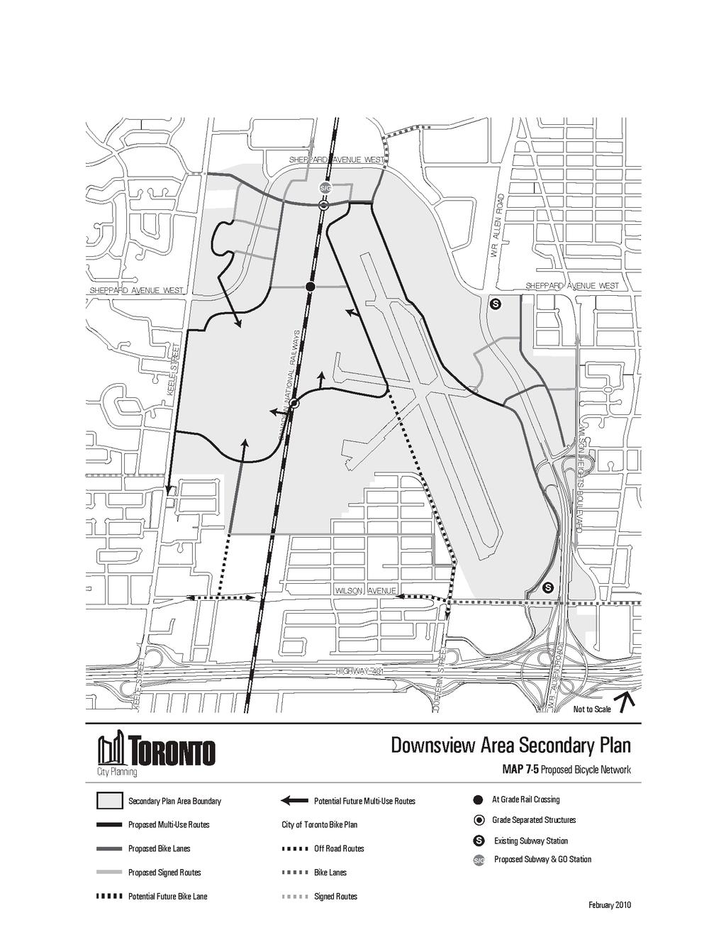
5 2.3 Transportation The Secondary Plan will be supported by excellent transit infrastructure including three TTC subway stations, a GO Transit rail station which will be integrated with the TTC, and surface transit. Future development will also be supported by street improvements that include the introduction of new municipally and federally-owned streets through the Secondary Plan area and grade separated crossings across the rail line. The development provided for in this Secondary Plan is supported by the transportation system and its associated rights-of-way recommended in the Downsview Area Secondary Plan Transportation Master Plan (2010). The recommended transportation system will achieve a balanced range of travel options that encourage walking, cycling and transit to make the most efficient use of existing and future transportation infrastructure and to support the continued development of the Secondary Plan Transportation planning in support of development within the Secondary Plan area will be undertaken in relation to the principles and objectives of the Downsview Area Secondary Plan Transportation Master Plan (2010) which include: a) Identifying future transportation demands in the Secondary Plan area based on the recommended growth strategy, prevailing demographic trends, and travel patterns within and throughout the Greater Toronto Area; b) Evaluating policies and transportation strategies required to accommodate planned growth and promote a greater balance between transportation nodes while protecting the ability to move people, goods and services in a manner that supports economic growth; c) Recommending short and long term infrastructure requirements considering the benefits and impacts of social/cultural, economic and environmental implications; d) Identifying and implementing strategies that integrate infrastructure with growth and the fiscal realities currently faced by municipalities throughout the province; and e) Establishing a plan monitoring framework that recognizes that a Transportation Master Plan is a living document and must be adaptable to changes in land use development patterns, travel behaviour, and changes in policy direction and other conditions in the City Required transportation improvements to accommodate development within the Secondary Plan area are shown on Maps 7-4, 7-5 and All new streets shown on Map 7-4 are to be municipal streets Potential Future Streets identified on Map 7-4 show street connections that were identified in the Downsview Area Transportation Master Plan (2010) to provide opportunities to improve street network connections. A study shall be undertaken by the City to determine if a future below grade east-west connection under the existing Bombardier Aerospace runway is possible The location and design of minor and major streets shown on Map 7-4, road improvements and intersection improvements are subject to the requirements of the Environmental Assessment Act. The Transportation Master Plan forms the basis and foundation for future environmental assessments that may be required for specific transportation works under the Class Environmental Assessment for Municipal Road Projects. In accordance with the Class Environmental Assessment requirements, the work undertaken as part of the Master Plan Transportation Study is recognized as the first two phases of the planning and design process of the Class Environmental Assessment. Subsequent phases will result in an Environmental Study Report (ESR) that will detail potential social, economic and environmental effects of specific 4
6 projects and appropriate mitigation measures. The minor and major streets shown on Map 7-4 are conceptual. The exact number and location of minor streets will be determined at the district plan stage All improvements to the transportation system will be developed as integral extensions to the City s public street network, bike plan and pedestrian plan Surrounding local streets will not be used to support the transportation needs of development in the Secondary Plan area. The street network shown on Map 7-4 is intended to support both existing and proposed development levels in the entire Secondary Plan area, including the redirection of Bombardier Aerospace traffic away from the existing residential neighbourhoods to the south of the plant Grade separated crossings shown on Map 7-4 are required to support development in the Secondary Plan area and will be protected for. Their design will be subject to more detailed evaluation as development occurs in the Secondary Plan area. All grade separated crossings will be designed and constructed to safely and comfortably accommodate pedestrian, bicycle, transit and vehicle functions as well as streetscape elements All municipal streets and municipal servicing infrastructure will be constructed to standards acceptable to the City and provided at approved locations and conveyed to the City at nominal cost and free of encumbrances, prior to the occupancy of development requiring that infrastructure. Functional segments of a required municipal street may be assumed by the City at the discretion of the City. A staged implementation of major and minor streets and municipal infrastructure will be considered Permanent or temporary tie-ins or easements to private streets within the National Urban Park may be permitted at the discretion of the City The existing configuration and physical structure of the on and off ramps that move traffic to and from Wilson Heights Boulevard and Allen Road shall be preserved and maintained The introduction of additional transit routes and connections to support development within the Secondary Plan area is encouraged Existing pedestrian links to rapid transit stations will be improved as development occurs to further encourage transit use by existing and future residents and employees Short-term and secure bicycle parking facilities will be provided in new public and private developments, including subway stations, having regard for City of Toronto bicycle parking policies and guidelines The creation of bicycle sharing stations, particularly at subway stations and other major activity centres, will be encouraged as an additional measure to reduce dependence on private auto use Appropriate parking standards will be established through implementing zoning having regard for proximity to public transit, shared parking and transportation demand strategies With the exception of lands within the National Urban Park District, the establishment of new surface parking lots or the expansion of existing surface parking lots is discouraged and the removal of existing surface parking is encouraged. New or replacement parking lots for any development, other than re-use or conversions of existing buildings, should be provided below grade. Surface parking should be limited generally to short term visitor and car share parking, with other parking provided underground to the greatest extent practical. It is recognized that below grade parking facilities may not be feasible in all cases and in such instances, surface parking should be screened from the public realm by buildings and/or landscaping. Alternative 5
7 parking solutions such as satellite or shared parking and structured parking facilities will be considered. A limited amount of convenience surface parking spaces to accommodate pick-up and drop-off activities may also be considered for multi-unit, mixed-use or nonresidential developments and rapid transit facilities. On-street parking will be considered where appropriate In the National Urban Park District small surface parking areas may be permitted based on a consideration of opportunities for shared parking to minimize the number of spaces required and access and distance to public transit To facilitate traffic flow, the number of vehicle access points from public streets to private redevelopment sites will be minimized particularly on major streets Office and other employment development proponents will be encouraged to develop and implement appropriate travel demand management strategies to reduce peak period automobile trips, and facilitate non-auto modes of travel such as transit, walking and cycling. In addition, measures to support transit use such as maximum parking standards, shared parking arrangements, public parking structures and payment-in-lieu of parking may be considered on sites within walking distances of rapid transit stations The City will work with developers, owners and tenants in the area to develop, implement, facilitate and promote measures to increase the use of transit, cycling and walking, and reduce the use of private automobiles for trips, particularly work trips, to and from the Secondary Plan area A well-connected network of cycling and pedestrian routes will be provided as shown in Maps 7-5 and 7-6. The location and design of these routes and facilities may be further refined through the district planning process Pedestrian and bicycle routes should be clearly identified with appropriate signage and pavement markings, as outlined in the City of Toronto Bikeway Networking signage system. Providing additional signage elements, such as distances to nearby major destinations, is encouraged To ensure pedestrian and cyclist comfort and safety, routes will be well-designed, attractive, appropriately lit and maintained. 6
8 3. SUPPORTING GROWTH The layout, organization and design of the public realm and relationships between new buildings and the public realm is a key component of establishing an urban and park-like character and identity for the Secondary Plan area. New buildings should fit together and define and support the edges of the public realm to provide well-defined, vibrant urban spaces where residents can work, live, play and interact with each other. 3.1 Public Realm The streets, parks, accessible landscapes and public buildings are the elements of the public realm A high quality public realm will be established and organized to physically connect Districts within the Secondary Plan area to each other and to the surrounding City and be designed to support the goal of achieving an urban and park-like character for the Secondary Plan area Streets identified on Map 7-2 as requiring an enhanced streetscape play a more important role in providing connections and linkages, particularly to the National Urban Park. These streets will be designed to provide safe, comfortable and amenable pedestrian and cycling routes/ environments, enhanced street tree planting and other streetscape features such as street furniture and pedestrian lighting Park space directly adjacent to the new TTC/GO Transit hub entrances will be developed as important urban open spaces. The design and programming of these urban open spaces will reinforce the complementary relationship between the City and the National Urban Park and support the highest standard of urban design. The location, organization and design of the street network, landscaping and the park space and buildings around the station will support this role. The transit station entrances and the park space around the entrances will be designed to accommodate occasional large pedestrian volumes that are destined to the National Urban Park Lands associated with or immediately adjacent to the Downsview or Wilson subway stations should be developed to create highly accessible and visible pedestrian station entrances facing and with direct access from Sheppard Avenue, Allen Road and Wilson Avenue If the TTC Rail Yard is subject to any development applications or the Transit Road alignment adjacent to the Rail Yard is modified, improvements to the public realm on Transit Road abutting the Rail Yard lands will be pursued with a priority on achieving pedestrian improvements and streetscape amenities. 3.2 Built Form Building height and scale will be organized with the tallest buildings and greatest scale of development located at the intersections of major streets, fronting onto major streets, or near a transit station The predominant scale of built form in the Secondary Plan area will be mid-rise buildings fronting public streets. Mid-rise buildings are buildings that have a maximum height that equals the width of the adjacent street right-of-way. 7
9 Development within Districts will be organized by a fine-grain of municipally and federally owned streets and will have a connected and continuous coordinated built form that defines and supports the public realm Low-rise development will be located in Neighbourhoods. Low-rise buildings are four storeys or less Where feasible, development should be sited to maximize passive energy capture to support sustainable development and design consistent with the City s Climate Change Action Plan and Energy Strategy Private open space on a development block will be organized and located to provide amenity for residents and workers on the block Sites which terminate or frame important views will organize development and locate buildings and landscape to maintain and enhance public access to such views. Development will not obstruct the Significant Views and Vistas identified on Map Public Art Public Art contributes to a strong sense of place and can strengthen local identity and image. The potential for public art to support and enhance the park-like setting central to the Secondary Plan areas character provides a compelling reason to encourage the provision of public art New developments of significant scale or in prominent locations are encouraged to provide on-site public art in publicly visible and accessible locations in accordance with the City s guidelines The identification of potential public art locations and opportunities will be included in District Plans in accordance with the policies of this Secondary Plan Parc Downsview Park Inc. and other landowners within the Secondary Plan Area are is strongly encouraged to develop a District Public Art Plan for the Secondary Plan Area to ensure public art is provided in a coordinated manner. 3.4 Heritage and Archaeology Downsview has a number of heritage resources that reflect the area s aviation and military history. These resources include buildings as well as landscape features. The Heritage Building Conservation Review Study (2009) prepared in support of this Secondary Plan identified a number of built and cultural landscape heritage resources of relevance. This document will inform and guide future decisions regarding heritage resources within the Secondary Plan area. All of the identified heritage buildings are located on lands under federal ownership which places them under the authority of the Federal Heritage Building Review Office (FHBRO). The City will consult and communicate with FHBRO on matters that affect heritage resources on federal lands. 8
10 3.4.1 Buildings possessing cultural heritage value or interest and potential cultural heritage landscapes are shown as heritage resources on Map 7-7 and will be conserved in accordance with the Official Plan and the Standards and Guidelines for the Conservation of Historic Places in Canada Heritage Impact Assessments will be required to be submitted for development proposals which affect heritage resources Development should conserve built and landscape heritage resources and be of a scale, form and character that supports and complements these resources Areas identified as having potential archaeological resources are shown on Map 7-7. Any soil disturbance or proposed development in these areas will require a Stage 2 Archaeological Assessment to be submitted. 3.5 Housing The large size of the Secondary Plan area and the areas designated for residential uses will result in a number of new neighbourhoods to be developed over time. To meet the needs of Toronto s residents, new neighbourhoods will contain a mix of housing that contributes to the full range of housing in terms of type, tenure and affordability. Affordable housing and rental housing are important components of a healthy housing mix. The amount of land to be developed for new housing in the Secondary Plan area offers an opportunity for the significant achievement of affordable housing and rental housing. A strategy for providing affordable housing will be included in the development approvals for each District. The following policies will ensure the successful development of the diverse, healthy communities that Toronto needs to thrive New residential development will achieve a full range of housing opportunities by type, affordability and tenure, including purpose-built rental housing, both within Districts and over the entire Secondary Plan area A minimum of 30 percent of new housing units in each District will be in forms other than single-detached and semi-detached houses. The variety of unit types provided should include housing with 3 or more bedrooms Affordable housing will be required in the Secondary Plan area and all affordable housing units will be provided within the Secondary Plan area as part of a community benefit under Section 37 of the Planning Act and such units will be distributed proportionally across and within Districts that permit residential uses Based on the residential development permissions provided for in this Secondary Plan, affordable housing will be provided on the Parc Downsview Park Inc. and Build Toronto lands as follows: a) Parc Downsview Park Inc. - a minimum of 720 affordable housing units on lands which permit residential uses and are under their ownership or authority at the time of the adoption of the Secondary Plan. b) Build Toronto a minimum of 300 affordable housing units on lands which permit residential uses and are under their ownership or authority at the time of the adoption of the Secondary Plan. 9
11 3.5.5 The affordable housing requirement for each of Parc Downsview Park Inc. and Build Toronto will be re-evaluated if additional residential development beyond that provided for in this Secondary Plan is proposed or being considered The affordable housing requirement, set out in Section 3.5.4, will be calculated and achieved on a District basis and will not be based on the size of individual development parcels within Districts. The City may permit at its discretion a variation in the proportion of affordable housing provided within a District, provided that a mix of housing is achieved in the District and the overall requirement for the Secondary Plan Area is not reduced The affordable housing requirement, set out in Section 3.5.4, may be achieved by the conveyance of land in the Secondary Plan area to the City, subject to the City, at its discretion, accepting the owner s proposal Affordable housing units in each District will be provided generally in the same proportion (total number of units) and mix (unit type) as the residential units that are not affordable housing units. This includes providing grade-related units with 3 or more bedrooms if this type of housing is being provided. A higher proportion of units with 2 or more bedrooms in the affordable housing component will be encouraged At least 50 percent of all affordable housing units will be affordable rental housing An affordable housing strategy is required at the District Plan stage that provides for the achievement of the affordable housing requirements in the District Affordable housing strategies will include: a) numerical targets by tenure and unit type, and by development parcel or phase within the context of the proposals for development of the housing that does not include affordable units; and b) the proposed order of development within the District, and the identification of how the affordable housing will be delivered to ensure that affordable housing requirements are achieved prior to or at the same rate as development of the non-affordable housing units; and c) proposals to meet any of the affordable housing requirements through the conveyance of land to the City, at the City s discretion; and d) for Parc Downsview Park Inc., for the second and subsequent Districts, the affordable housing strategies shall also report on the achievement of affordable housing to date in all Districts and any proposed modifications to future achievement The Canadian Forces Housing Agency (CFHA) is allocated 225 residential units to replace their existing military housing in the Secondary Plan area. For the purpose of determining affordable housing requirements, CFHA housing is excluded from any calculation of total housing units or affordable housing units, and is not interpreted to be affordable housing for the purposes of the Official Plan. The CFHA is strongly encouraged to develop a full range of housing types to provide for the varied housing needs of the Canadian Armed Forces personnel and their families Implementation of affordable housing strategies as per Section will be secured through the use of such mechanisms as agreements between public agencies and the City, conditions for the release of holding provisions for zoning and agreements pursuant to Section 114 of the City of Toronto Act (2006) and Sections 37, 41, 51 or 54 of the Planning Act. 10
12 3.6 Community Services and Facilities Ensuring that new residents are provided with affordable, accessible, high quality community services and facilities in a timely manner is necessary to achieve liveable and sustainable urban communities Community services and facilities will be required to support and meet the needs of residents and employees in the Secondary Plan area and will be provided in conjunction with new development in the Secondary Plan area A community centre with an indoor pool will be required to support the level of development provided for in this Secondary Plan. Other community service and facility priorities include child-care centres. Appendix 1 to this Plan identifies community services and facilities requirements as determined at the time of preparation of this Plan Community services and facilities will be: a) located within the Secondary Plan area in close proximity to the resident and worker population they serve; b) located in highly visible and accessible locations with strong pedestrian and transit connections; c) be designed in a manner that promotes the development of flexible multi-purpose facilities that can be adjusted to meet the varied needs of the Secondary Plan area and surrounding communities; and d) delivered in a timely manner to support residential and non-residential growth so as not to place additional burdens on existing community services and facilities in the area where available capacity may not exist Community Service and Facility Strategies will be required either as part of the District Plan or with the submission of development applications. These Community Service and Facility Strategies will provide approaches to address the community service and facility priorities identified in this Secondary Plan, particularly the provision of sufficient accessible child care spaces. The Community Service and Facility Strategies will be used to determine preferred locations for community services and facilities and specific requirements based on: a) the actual land uses and densities, including the provision of affordable housing, that will or have been developed in each District; b) inventories of existing facilities and services; c) identification of gaps in service provision; and d) consideration of the facilities and services provided by PDPI Innovative approaches for providing community infrastructure will be considered, including shared uses and integrating facilities within private developments or the National Urban Park. In the case of a community centre, a stand alone facility will be provided and, where possible, allow for the sharing of that facility through joint programming Section 37 of the Planning Act may be one of the tools used by the City to secure community services and facilities within the Secondary Plan area. Section 37 contributions will be collected in accordance with Section 7.6 of this Secondary Plan and in accordance with the provisions of the Official Plan. 11
13 3.6.7 The City approved Toronto Fire Services Fire Master Plan (2007) identifies as one of its proposed station locations, a station on Keele Street between Wilson Avenue and Sheppard Avenue West. This station would primarily serve development in the vicinity of the Secondary Plan area and development anticipated within the Secondary Plan area, west of the CN rail line. Development in the Secondary Plan area can be phased through a Holding provision on the implementing zoning and/or conditions draft plan approval. 3.7 The Natural Environment A portion of the National Urban Park lands are being redeveloped from a former military base to a large, contiguous and diverse area comprised of Natural Areas and Parks which together will support natural wildlife habitat and recreation. The existing woodlot in the William Baker District is a significant natural heritage feature and the designation of this woodlot as Natural Areas in combination with the adjacent Parks will support, protect and enhance natural features and functions. The opportunity to conserve natural features and create an integrated and linked natural environment system within the Secondary Plan is encouraged, including the creation of linkages to the adjacent Black Creek and Don River-West Branch ravine systems Natural heritage features and parks will be developed to achieve a linked open space and natural heritage system as generally shown on Map 7-8 with the following objectives: a) protecting, restoring and enhancing natural heritage features; b) accommodating natural areas within the National Urban Park that support wetland, forest and meadow habitats; and c) creating natural linkages and greenways to connect the large woodlot natural heritage feature in the William Baker District, the natural areas in the National Urban Park, local parks in the Secondary Plan area and open space areas and valley corridors adjacent to the Secondary Plan area. Greenways are public corridors for pedestrians and cyclists that connect parks, natural heritage features, historic sites, cultural landscape features, neighbourhoods and other areas. Greenways expand opportunities for urban recreation, provide alternative ways to move through a City, and enhance the experience of nature, community and city life. 12
14 3.7.2 Prior to development or redevelopment adjacent to natural heritage features, a Natural Heritage Impact Study will be required in accordance with the Official Plan. Development includes roads and infrastructure Specific to woodlots, Natural Heritage Impact Studies will: a) identify the dripline and the determination of an appropriate naturalized buffer beyond the dripline for woodlots; b) identify approaches to improve hydrologic regime; and c) provide direction for a woodlot management /stewardship strategy, including the management of the naturalized buffer Development will not be permitted within natural heritage features or naturalized buffers The preparation of a woodlot management/stewardship strategy will be a condition of development approval and shall include adaptive management monitoring programs to: d) determine and measure the ongoing health of the woodlot; e) determine whether management practices implemented are effective; and f) determine if modifications are required due to unacceptable impacts from adjacent development Right-of-ways, and in particular those which align with the Greenways identified on Map 7-8, provide an opportunity to introduce enhanced street tree plantings and landscaping and should be designed and planted with the objective of improving natural connections and linkages and enhancing the urban forest The urban forest will be enhanced by increasing tree canopy coverage and diversity through the planting of large growing shade trees on public and private lands. 3.8 Environmental Stewardship and Sustainable Design Sustainable development reduces stress on the City s infrastructure. The Secondary Plan supports sustainability by focussing future growth around major transit facilities, and supporting and encouraging sustainable development practices Sustainable development strategies will be developed as a component of the District Plans and will identify the mechanisms and techniques to be used to mitigate the environmental impacts of development such as: district heating/cooling; renewable energy; green roofs; bio-swales; permeable paving; and rainwater harvesting As a means of implementing sustainable site and building design, development or redevelopment is encouraged to meet Tier 2 - the enhanced sustainable performance measures - of the Toronto Green Standard Prior to development proceeding within each of the Allen, Sheppard-Chesswood, William Baker and Wilson Districts, a Community Energy Plan will be completed to provide guidance and direction on how development can support the City s Climate Change Action Plan and Energy Strategy The production of local, urban food through the cultivation of community gardens within the Secondary Plan area is encouraged. Emerging urban agricultural trends such as vertical agriculture is encouraged. 13
15 3.9 Municipal Servicing Ensuring there is sufficient municipal servicing capacity to accommodate the anticipated growth is critical to the success of this Secondary Plan. Stormwater or wet weather flow within the Secondary Plan area will be managed on a systems basis taking into account the entire watershed, recognizing that upstream water conditions and its treatment may have downstream impacts. A variety of existing and emerging techniques such as stormwater ponds, bio-swales, green roofs, rainwater harvesting and permeable pavement will be used to reduce stormwater flows, improve environmental sustainability and make positive contributions to the look and feel of the Secondary Plan area Municipal infrastructure in support of development within the Secondary Plan area will be undertaken in relation to the principles and objectives of the Downsview Area Secondary Plan Infrastructure Master Plan (2010) Municipal infrastructure required to service new development will be provided on municipal lands typically within the public street right-of-way or within dedicated easements The City will monitor and assess the capacity in the Black Creek/Humber sanitary trunk system as lands in this Secondary Plan and other areas develop to determine if capital improvements will be required Functional servicing reports will be required on a District basis to: a) identify whether sufficient capacity exists within the trunk and local municipal servicing to accommodate proposed development; b) identify any improvements required to existing municipal servicing to support the proposed type and level of development including the need for a trunk sewer on Keele Street for those developments which would connect to the Black Creek/Humber sanitary trunk system; and c) determine mitigation measures to minimize any impacts Stormwater management plans will be required on a District basis to identify how stormwater is being managed within the District in accordance with the City s Wet Weather Flow Master Plan Municipal servicing will be co-ordinated with the detailed design of the public street network Public streets and municipal servicing will be constructed to City standards and be provided at approved locations and conveyed to the City at nominal cost and free of encumbrances, prior to the occupancy of development requiring that infrastructure. Where public streets are being constructed, municipal infrastructure may be required to be provided concurrently within the right-of-way in advance of development requiring that infrastructure. 14
16 4. DEVELOPMENT There are five land use designations within the Secondary Plan area as shown on Map 7-9. The land use policies implement the development framework provided for in this Secondary Plan. 4.1 Neighbourhoods The use of rear lanes or shared private driveways for vehicle access to residential development is encouraged in Neighbourhoods and will be required for development along Wilson Heights Boulevard and major streets shown on Map 7-4 within or abutting Neighbourhoods. 4.2 Apartment Neighbourhoods Within the Stanley Greene District, the Apartment Neighbourhoods designation will: a) provide for mid-rise buildings along Keele Street and an appropriate transition in building height and massing to the adjacent Neighbourhoods; b) provide for low-rise apartment buildings along the south edge of the National Urban Park; and c) allow for low-rise apartment buildings as part of the provision of a variety of dwelling types that may be delivered specifically for the Canadian Forces Housing Agency. 4.3 Parks and Open Space Areas The parks and open space system within the Secondary Plan area is envisioned to develop with the National Urban Park being the focus of a connected network of parks and natural areas. The Secondary Plan parks and open space system will ultimately connect to the City broader parks and open space system, in particular the Black Creek system immediately west of Keele Street New local parks will be required within Districts in the Secondary Plan area to provide a focus and serve the recreational needs of persons living and working in the area. Local parks will be developed and maintained to provide space for public recreational, athletic and landscaping purposes to accommodate active and passive recreation Local parks will be prominent features within neighbourhoods, centrally located within the Districts, situated on public streets in highly visible and easily accessible locations, and provide linkage and connectivity to the National Urban Park and to other parks and open spaces throughout the Secondary Plan area Preferred locations for municipal parks are shown on Map 7-8. The exact size, configuration and location of municipal parks will be determined at the District Plan stage and guided by the following objectives: a) William Baker - the park will be adjacent to the natural heritage feature. The objective is to create a unique recreation space that is in a natural setting with transitions between the edge of the woodlot, the naturalized buffer area, and active recreation areas. 15
17 b) Allen - three parks will be provided in the Allen District as shown on Map 7-8. On the east side of Allen Road a Greenway that is approximately 20 metres wide will connect to the existing Banting Park and a new park at the south end of the District. c) Stanley Greene - the park will be centrally located within the District along a north-south street that will connect to the National Urban Park. The north-south street will be enhanced with landscaping and street trees to create an attractive pedestrian-friendly environment and achieve an important view corridor to the National Urban Park. d) Sheppard-Chesswood - the park space directly adjacent to the new TTC/GO Transit hub entrances will be developed as important urban open spaces and will be of a high quality design to reinforce the importance of this site as a front-door to the National Urban Park for transit users Parks may include joint community and school facilities that are integrated with open space and recreational uses Where schools and community facilities are co-located on Parks, multi-storied buildings and underground parking facilities are encouraged to maximize the amount of land available for recreation, landscaping and open space purposes A maximum of 4 percent of lands designated Parks and Open Space Areas Parks may be used for buildings and structures. 4.4 Employment Areas The Secondary Plan area contains employment uses with large land area requirements: the Bombardier Aerospace manufacturing facility and associated runway; the Department of National Defence; and the Toronto Transit Commission rail yards. The intent of the Secondary Plan is to continue to support these uses as their surroundings evolve and urbanize The Bombardier Aerospace lands, which include the manufacturing operations and the airport runway, are recognized as a large employment use within the Secondary Plan area. Development proposals for the Bombardier Aerospace lands will be evaluated to determine impacts on the aviation manufacturing and testing operations of these lands The Department of National Defence (DND) lands are recognized as lands used for military purposes, including administrative and armoury uses, research and office uses associated with the military, training activities and supportive uses such as a daycare and family resource centre. Development adjacent to DND lands may be impacted by DND security requirements Notwithstanding the Employment Areas policies of the Official Plan, the TTC parking lot on the south side of Wilson Avenue between Billy Bishop Way and Allen Road, will continue to be permitted to develop with retail and service uses such as retail stores, restaurants, supermarkets and complementary retail and service uses. 4.5 Mixed Use Areas Lands designated Mixed Use Areas are located around the Downsview subway station and along Keele Street north of Sheppard Avenue. These locations are in transit supportive locations, on Avenues, and can support an increased scale and level of development without conflicting with flight operations of the nearby airport runway. These lands are encouraged to develop with intensive mixed use, transit-oriented development. In particular, the lands around the Downsview subway station are encouraged to develop as a sub-centre with predominantly commercial and office uses. 16

18 4.5.1 The predominant use of land in the Allen District at the intersection of Sheppard Avenue West and Allen Road will be for office, retail and service commercial purposes. 5. DENSITY The mix of land uses and levels of development provided for by this Secondary Plan reflect the utilization of transportation infrastructure assuming the Toronto-York Spadina Subway Extension and all new streets are developed and the Bombardier airport height restrictions remain. Minimum and maximum gross densities have been established. Minimum densities will ensure that sufficient development occurs to support the investment in higher-order transit infrastructure. 5.1 Minimum gross density requirements are shown on Map 7-10 and maximum gross density permissions are shown on Map In the event that the Toronto-York Spadina Subway Extension is not completed and opened as planned with a station within the Secondary Plan area, the density permissions in this Secondary Plan will be re-evaluated. Density Densities are measured using Floor Space Index (FSI) which, for the purposes of this Secondary Plan, is the ratio of gross floor area of all buildings in an identified density area as shown on Map 7-11 divided by the total land area of the identified density area. Density on any individual lot may exceed the FSI for the identified density area, provided that the overall FSI for the density area is not exceeded. Gross development block areas include the land for the buildings, lands dedicated for streets, community services and facilities, parkland, open spaces and transit facilities. Net development sites exclude lands dedicated for streets, community services and facilities, parkland, open space and transit facilities. 5.3 In the event that Bombardier s airport height restrictions are modified to permit additional height around the subway within the Sheppard- Chesswood and Wilson Districts, the maximum density permissions within these Districts will be re-evaluated. 5.4 Maximum density permissions may also be re-evaluated as a result of transportation monitoring undertaken for the Secondary Plan area and/or a comprehensive transportation assessment completed as part of a District Plan. Transportation monitoring will be undertaken as set out in Section Notwithstanding Policy 5.4, if key major streets as shown on Map 7-4 have been constructed and resulting transportation monitoring identifies additional capacity, additional density to a maximum increase of 0.5 FSI may be permitted in the Apartment Neighbourhoods in the Allen District without an amendment to this Secondary Plan. 17
19 5.6 Notwithstanding Policy 5.1, but subject to all policies of this Secondary Plan, City Council may pass Zoning By-law Amendments to permit a density of up to 0.85 FSI to a maximum of 450 units in the Neighbourhoods in the Allen District without an amendment to the Secondary Plan. 6. HEIGHT The Secondary Plan provides for a range of building types and heights to achieve appropriate building scale and relationships to the public realm and adjacent buildings. 6.1 Building heights, except where not possible due to airport operational requirements, will be a minimum of: a) 13.5 metres or four storeys for buildings fronting Keele Street, Sheppard Avenue, Wilson Avenue or Allen Road; b) 10.5 metres or three storeys for buildings fronting other major streets shown on Map 7-4; and c) 6 metres or two storeys for buildings fronting minor streets. 6.2 The ground floor of multi-storey mixed-use or non-residential buildings will be a minimum of 4.5 metres in height. 6.3 Maximum building heights will be evaluated and examined through the District Plans, in consideration of Bombardier airport height restrictions and established through implementing zoning. 7. IMPLEMENTATION 7.1 District Plans District Plans will outline area specific development principles and guidelines at a level of detail not possible within the Secondary Plan. These principles and guidelines form the bridge that allows the City to move from Official Plan policies to Zoning By-law provisions. District Plans are intended to provide a context for coordinated development, a framework within which capital initiatives for the public realm may be developed and a tool to evaluate a development s conformity with the Official Plan The boundaries of the Districts on Map 7-3 are general. Where the general intent of the Secondary Plan is maintained, minor adjustments to the District boundaries will not require an amendment to this Secondary Plan District Plans are required to be completed to the satisfaction of the City prior to any development proceeding in a District, except for development of transit infrastructure. District Plans will be submitted prior to or as part of a development application. District Plans are meant to provide a context within which to prepare and review development applications, such as Zoning By-law Amendments and Draft Plans of Subdivision District Plans will typically include: a) a description of the intended character as outlined in Section 2.2 of the Secondary Plan and the key elements of the District; 18
20 b) structure and block plans; c) context plan showing how the public road and parks and open space network will be integrated with surrounding lands, including pedestrian and bicycle connections; d) the land use mix; e) conceptual building locations and massing; f) how elements of Map 7-2 Structure Plan are being addressed; and phasing The following studies, strategies and reports may be required at the District Plan stage: a) public art strategies; b) provisions for securing the conservation of heritage buildings and resources; c) Stage 2 Archaeological Assessments; d) community services and facilities strategy; e) affordable housing strategy; f) natural heritage impact study; g) urban design guidelines; h) sustainability strategy (Community Energy Plan); i) functional servicing reports; j) stormwater management reports; and k) transportation impact studies Urban design guidelines may take the form of an update to the existing approved Downsview Area or Allen-Sheppard Urban Design Guidelines, or new urban design guidelines. In either form these will include the following information: a) the design framework for the public realm and the relationship of buildings and private spaces to the public realm; b) urban design concepts for the lands to support the coordination of development of individual sites and blocks; c) the location, treatment and character of component elements of the open space network including streets, parks and accessible open space on private lands; d) requirements to ensure attractive, safe and pedestrian friendly streets; e) requirements to protect natural heritage features; f) criteria for ensuring appropriate urban built form and massing, public safety and pedestrian circulation; g) locations for public art; and h) criteria ensuring new development respects and supports identified heritage resources. 7.2 Transportation Monitoring Development in the Secondary Plan area is expected to occur over many years, and the timing and phasing of necessary transportation infrastructure improvements will depend on a number of factors, including the nature and rate of development and future travel characteristics. The ultimate location and detailed design of streets and intersections are subject to the requirements of the Environmental Assessment Act. 19
21 7.2.1 A transportation monitoring program will be developed with stakeholders to monitor the development levels and trends and associated travel characteristics. The monitoring program will address: a) traffic volumes on major streets and at key intersections, based on periodic traffic counts in the area; b) travel characteristics of employees, residents and visitors, including vehicle occupancy, modal split, trip distribution and peak hours of travel; c) evaluation of traffic volumes and transit ridership in the context of available capacity; d) parking availability, location and the impacts of pricing policies; e) evaluation of existing, planned and proposed development; f) traffic infiltration in residential areas; and g) the results of Transportation Demand Management measures and the extent to which the objectives of the Downsview Area Secondary Plan Transportation Master Plan are being achieved The findings of the transportation monitoring program will form the basis of future comprehensive transportation analyses, will inform the periodic reviews of the Secondary Plan, and may be considered in the review of individual development applications and the development of local neighbourhood traffic management plans To ensure that transportation issues are addressed, Transportation Impact Studies must be submitted which take into account the development potential for a particular District prior to the enactment of a Zoning By-law and that: a) identify pedestrian cycling opportunities with regard to policy, guidelines and other requirements; b) assess the overall impact of development in the District on the transportation system and demonstrates that development traffic will not contribute to significantly reducing the level of service of the public street network; c) identify, consider and evaluate transportation improvements or mitigating measures to address transportation impacts; d) demonstrates that the proposed development parking supply conforms with the policies of the City of Toronto; and e) identify, consider and evaluate measures to assist in reducing vehicular trips. 7.3 Zoning By-law Zoning for the Secondary Plan area may be implemented comprehensively or in stages The enactment of implementing Zoning By-laws may be with held until satisfactory arrangements have been made for the timely provision of affordable housing, transportation and servicing infrastructure and community services and facilities. 20
22 7.4 Plan of Subdivision and Consent All division of land in the Secondary Plan area will be in conformity with this Secondary Plan. Division of land will create land parcels that facilitate development consistent with the intent and objectives of this Secondary Plan and which can be developed in accordance with the District Plans approved by the City. 7.5 Site Plan Control Applications for Site Plan Control will be used to implement the intent and objectives of this Secondary Plan and to implement urban design guidelines adopted for the Secondary Plan area. Site Plan review will consider the context of a proposal within the larger block on which the site is located to ensure coordinated development. 7.6 Height and/or Density Incentives Agreements pursuant to Section 37 of the Planning Act will be used to secure community services and facilities, and the implementation of the housing policies of this Secondary Plan Section 37 benefits other than the provision of the affordable housing requirements will be selected on the basis of local community needs, the nature of the District Plans and individual development applications, any implementation guidelines or plans approved by the City and the strategic objectives and policies of this Secondary Plan Monetary contributions towards the cost of constructing and furnishing community services and facilities will be determined by: a) establishing the capital cost of the facility(s) and the total value of the monetary contribution after development charge contributions are determined; b) identifying the required facilities to support the amount of proposed residential and nonresidential development through community services and facilities strategies; c) allocating the overall capital costs of such facilities, after deducting development charge contributions, between residential and non-residential development in the same proportions represented by the respective density increases in relation to the overall density increase, with all increases determined by the overall densities permitted in this Secondary Plan as compared to the previous Secondary Plan; d) distributing the share of capital costs allocated to the residential sector on a per square metre of gross floor area based on maximum residential densities for all residential development provided for in this Secondary Plan minus the gross floor area attributed to affordable housing provided for in this Secondary Plan; and e) distributing the share of capital costs allocated to the non- residential sector on a per square metre of gross floor area based on maximum non-residential densities for all non-residential development provided for in this Plan Established monetary contributions will be increased over time in accordance with the Non- Residential Construction Price Index for Toronto published by Statistics Canada. 21
23 7.7 Holding Zones Zoning for any of the lands within the Secondary Plan area may include holding provisions in accordance with the Planning Act. Lands subject to these provisions shall be identified by the holding symbol H preceding the zone symbol on the map. The uses of land, buildings or structures that are permitted when the holding symbol is removed shall be specified in the Holding Zone By-law The Holding (H) Symbol may be removed in phases upon application by the owner to the City and only as the following plans and studies have been provided and appropriate conditions secured through an agreement or agreements pursuant to the Ontario Heritage Act, Sections 111 and 114 of the City of Toronto Act, or Sections 37, 41, 51 or 53 of the Planning Act: a) Housing Issues Report; b) Urban Design Guidelines Update; c) Community Services and Facilities Strategies; d) Stage 2 Archaeology Assessment; e) Heritage Impact Statement; f) Natural Heritage Impact Study; g) Transportation Impact Study and Update; h) Servicing and Stormwater Management Report; and i) Consideration of financial implications and the timing of the provision of transit services and municipal infrastructure and services. A Housing Issues Report is required for an application to lift the Holding (H) Symbol for Zoning. The report is intended to provide the City with the necessary details on the prior or proposed achievement of the affordable housing requirements relative to the development of the market housing in the District. The information is focused on demonstrating how and when the housing requirements are being met, either on the specific lands subject to the application to lift the (H) or on other lands in the District. The report will provide specific information on progress to date and what is proposed, including the unit mixes of the affordable and market components, and is more limited in scope than the previously approved Affordable Housing Strategy for each District The requirements for the removal of the Holding (H) Symbol may be reduced upon consideration of circumstances unique to a development proposal or the achievement of required infrastructure or services. 7.8 Interpretation The Secondary Plan should be read as a whole to understand its comprehensive and integrative intent as a policy framework for decision making The numbered policies (shaded text) and maps of this Secondary Plan are the Secondary Plan s policies. Other non-policy text (unshaded text) is 22
24 provided to give context and background and assist in understanding the intent of the Secondary Plan s Policies Appendix 1 is part of the Secondary Plan for the purpose of identifying projected community service and facility needs for the land use and density permissions provided by this Secondary Plan. Amendments to the Secondary Plan are not required for any revisions to this Appendix Where the general intent of the Secondary Plan is maintained, minor adjustments to the boundaries on the respective Secondary Plan Maps will not require an amendment to this Secondary Plan The indication of any proposed streets, parks, municipal services or infrastructures in this Secondary Plan is not to be interpreted as being specifically or solely the responsibility of the City to provide, finance, implement or maintain 8. SITE AND AREA SPECIFIC This Secondary Plan distinguishes lands intended to be retained and developed by the federal crown corporation Parc Downsview Park Inc. for a National Urban Park. The following policies provide further clarification regarding the development of the National Urban Park to ensure the objectives of the Secondary Plan are met and to provide for the development of an important cultural and recreational destination locally, regionally and nationally. 1. National Urban Park Lands For the lands shown as 1: a) The National Urban Park lands are comprised of two land use designations, Parks and Open Space Areas Parks and Natural Areas and Employment Area as shown on Map 7-9, which will have a minimum combined total area of 119 hectares. a) National Urban Park lands designated Parks and Open Space Areas Parks and Natural Areas will: i. have a minimum area of 82 hectares; ii. support primarily parkland and open space uses; iii. not be used for the development of new principal buildings, however supportive buildings such as park washrooms, concession areas and park information buildings may be constructed on Parks lands provided they are of a size and scale that is ancillary to the park and open space function; and iv. provide for agriculture uses. a) National Urban Park Lands designated Employment Areas will: i. have a minimum area of 37 hectares; ii. only permit employment uses that support and relate to the National Urban Park including but not limited to: museums; art galleries; small craft industries; live/work for artists; recreation facilities; park and office administration uses; cultural uses; theatres; educational uses; market areas and ancillary retail and restaurant uses; and iii. on sites along Carl Hall Road primarily be developed in existing buildings and any new development or redevelopment should support the scale, organization and orientation of existing buildings to augment its rich inventory of heritage buildings and support the evolution of the street as a pedestrian oriented public designation and the cultural centre of the National Urban Park. 23
25 List of Maps Map 7-1 Map 7-2 Map 7-3 Map 7-4 Map 7-5 Map 7-6 Map 7-7 Map 7-8 Map 7-9 Map 7-10 Map 7-11 Secondary Plan Boundary Structure Plan Districts Proposed Street Network Proposed Bicycle Network Proposed Pedestrian Network Archaeology and Heritage Resources Conceptual Parks and Natural Heritage Features Land Use Minimum Density Requirements Maximum Density Permissions 24
26 APPENDIX 1: COMMUNITY SERVICES, FACILITIES AND LOCAL PARKS SUMMARY PROJECTED SECONDARY PLAN NEEDS Community Recreation Centre Approximately 460 daycare spaces for children age 0-9 years Approximately 13 hectares of local parkland GENERAL CRITERIA Facility/Site Requirements: Shared use of sites and/or multi-purpose facilities Capacity to adapt to changing needs of the community over time Community facilities could be integrated as part of mixed-use developments Incorporated as part of development sites or as stand alone facilities, and where possible, to allow for the sharing of facilities and joint programming. Where schools and community facilities are co-located on parks, multi-storied buildings and underground parking facilities are encouraged to maximize the amount of land available for recreation, landscaping and open space purposes Location Criteria: Accessible by public transit Barrier-free Grade-related Good visibility from main streets Located in close proximity to residents and businesses of the Secondary Plan area Implementation Guidelines: Delivered in a timely manner to support residential and non-residential growth Monitoring and review of adequacy of the community facilities shall occur through the District planning process as development advances in each District Equitable contributions by landowners for the costs of any new community facilities required to support overall development of the Secondary Plan area, over and above development charges and park levies, may be required 25
27 COMMUNITY RECREATION CENTRES Facility/ Site Requirements: Minimum of 6,950 m2 of gross floor area all within one building which shall include an aquatics area, including a lane pool of 25 metres by 6 lanes, a double gymnasium and a multi-use space Daycare facilities are encouraged to locate within the community recreation centre Location Criteria: Guidelines: Located to provide easy access for surrounding neighbourhoods and businesses Good pedestrian and public transit access Highly visible from the street Ready access to outdoor playing fields and playgrounds (preferably a municipal park) Consideration must be given to passenger drop-off space, service access, pedestrian circulation, any associated outdoor amenity and recreation space, landscaping and building setbacks Flexible space to allow for different program and meeting requirements. DAYCARE CENTRES Facility/Site Requirements: Each daycare will accommodate between 52 to 86 children and have 110 square feet per child of interior space and 60 square feet per child of exterior play space The exterior surface must be adjacent to the interior space and all daycare centres must be fully equipped and furnished in accordance with Provincial requirements Acceptable access to the Daycare Centre for children, parents, custodians and staff including acceptable drop-off and pick-up locations of children Location Criteria: Grade location is preferable Compliance with appropriate provincial regulations and policies Sun, air and noise studies must be completed prior to final selection of sites Implementation Guidelines: Licensed daycare demand will be assessed as follows: number of children 0-9 years of age (11% of population citywide) reduced by 50% to reflect parental labour participation rates and parental choice with respect to licensed care 26
28 LOCAL PARKLAND Facility/Site Requirements: Approximately 13 hectares of dedicated municipal parkland is required, exclusive of any school facilities Local parkland will be neighbourhood oriented and provide passive and active recreational opportunities The exact size, configuration and location of municipal parkland will vary and be determined at the District planning stage Location Criteria: Preferred locations for parkland have been identified on Map 7-8 and the amount will be based on the development levels which is estimated to result in the following municipal parkland requirements: Stanley Greene 1.6 hectares; William Baker 3 hectares; Sheppard- Chesswood 2 hectares; Allen 5.7 hectares (including the existing 2.4 hectare Banting Park) Intended to serve communities within a reasonable walking distance Barrier free, grade-related and good access and visibility from streets Implementation Guidelines: Capacity to adapt to changing needs of the community over time Integrate neighbourhood parks and open spaces within the broader City system by establishing links using public streets that are landscaped and planted with street trees Include a network of paths and trails to provide for pedestrian and cyclist movement within the Secondary Plan area and connect with the broader City system Incorporate sustainable practices in park design and management 27
29 28 1
30 2 29
31 30 3
32 4 31
33 32 5
Director, Community Planning, North York District
 STAFF REPORT ACTION REQUIRED Final Report Downsview Area Secondary Plan Review Date: February 17, 2010 To: From: Wards: Reference Number: North York Community Council Director, Community Planning, North
Director, Community Planning, North York District
 STAFF REPORT ACTION REQUIRED 35 Carl Hall Rd, 0 Keele St E/S, 0 Allen Road W/S, 0 Dufferin St W/S, 1035 Sheppard Ave W, 64 Murray Rd, 0 Wilson Ave S/S, 0 Wilson Ave N/S, 160 Transit Rd, 0 Plewes Rd N/S,
Stanley Greene District Downsview (80 Carl Hall Road) Zoning By-law Amendment and Draft Plan of Subdivision Applications Request for Direction Report
 Zoning By-law Amendment and Draft Plan of Subdivision Applications Request for Direction Report") STAFF REPORT ACTION REQUIRED Stanley Greene District Downsview (80 Carl Hall Road) Zoning By-law Amendment and Draft Plan of Subdivision Applications Request for Direction Report Date: December 16, 2011
STAFF REPORT ACTION REQUIRED Stanley Greene District Downsview (80 Carl Hall Road) Zoning By-law Amendment and Draft Plan of Subdivision Applications Request for Direction Report Date: December 16, 2011
FORMER CANADIAN FORCES BASE (CFB) ROCKCLIFFE SECONDARY PLAN. Official Plan Amendment XX to the Official Plan for the City of Ottawa
 ROCKCLIFFE SECONDARY PLAN. Official Plan Amendment XX to the Official Plan for the City of Ottawa") FORMER CANADIAN FORCES BASE (CFB) ROCKCLIFFE SECONDARY PLAN Official Plan Amendment XX to the Official Plan for the City of Ottawa 1 INDEX THE STATEMENT OF COMPONENTS PART A THE PREAMBLE PAGE Purpose...
FORMER CANADIAN FORCES BASE (CFB) ROCKCLIFFE SECONDARY PLAN Official Plan Amendment XX to the Official Plan for the City of Ottawa 1 INDEX THE STATEMENT OF COMPONENTS PART A THE PREAMBLE PAGE Purpose...
The West Vaughan Employment Area Secondary Plan Policies
 Part 2: The West Vaughan Employment Area Secondary Plan Policies 2.1 General Policies It is the policy of Council: 2.1.1. That the West Vaughan Employment Area (the WVEA), identified on Schedule 1, will
Clairtrell Area Context Plan
 Clairtrell Area Context Plan March 2005 Urban Development Services City Planning Contents 1. Introduction... 4 2. Development Structure... 6 2.1 Streets... 7 2.1.1 Sheppard Avenue and Bayview Avenue...
Welcome. Walk Around. Talk to Us. Write Down Your Comments
 Welcome This is an information meeting introducing the applications for proposed redevelopment of the Yorkdale Shopping Centre site at 3401 Dufferin Street and 1 Yorkdale Road over the next 20+ years,
DAVENPORT VILLAGE SECONDARY PLAN
 27 DAVENPORT VILLAGE SECONDARY PLAN 27. DAVENPORT VILLAGE SECONDARY PLAN 1. VISION FOR THE DAVENPORT VILLAGE SECONDARY PLAN Davenport Village, municipally known as 830, 940, 980 and 1100 Lansdowne Avenue,
Mark-up of the effect of the proposed Bronte Village Growth Area OPA No.18 on the text of section 24, Bronte Village, of the Livable Oakville Plan
 Mark-up of the effect of the proposed Bronte Village Growth Area OPA No.18 on the text of section 24, Bronte Village, of the Livable Oakville Plan Notes: This document is provided for information purposes
8. NORTH YORK CENTRE SECONDARY PLAN
 8. NORTH YORK CENTRE SECONDARY PLAN 1. GENERAL CONCEPT AND OBJECTIVES This Secondary Plan forms the general basis for the redevelopment of the North York Centre as identified on Map 8-1. 1.1 North York
CONTENTS 8.0 LAND USE 8.1 GENERAL LAND USE 8.2 RESIDENTIAL 8.3 MIXED USE 8.4 COMMERCIAL 8.5 EMPLOYMENT LANDS
 8-2 Land Use 8.0 LAND USE CONTENTS 8.1 GENERAL LAND USE 8.1.1 Uses provided for in all Land Use Designations 8.1.2 Uses prohibited in Hazardous Lands, Hazardous Sites and Special Policy Areas 8.1.3 Uses
PORT WHITBY COMMUNITY
 PORT WHITBY COMMUNITY SECONDARY PLAN UPDATE COMMUNITY IMPROVEMENT PLAN URBAN DESIGN GUIDELINES September 2015 DRAFT PROPOSED AMENDMENT NUMBER # to the Whitby Official Plan PURPOSE: The intent of this Amendment
THE CITY OF VAUGHAN BY-LAW BY-LAW NUMBER A By-law to adopt Amendment Number 1 to the Official Plan of the Vaughan Planning Area.
 THE CITY OF VAUGHAN BY-LAW BY-LAW NUMBER 015-2014 A By-law to adopt Amendment Number 1 to the Official Plan of the Vaughan Planning Area. NOW THEREFORE the Council of the Corporation of the City of Vaughan
Bloor St. W. Rezoning - Preliminary Report
 STAFF REPORT ACTION REQUIRED 1638-1644 Bloor St. W. Rezoning - Preliminary Report Date: April 1, 2008 To: From: Wards: Reference Number: Toronto and East York Community Council Acting Director, Community
URBAN DESIGN BRIEF URBAN DESIGN BRIEF 721 FRANKLIN BLVD, CAMBRIDGE August 2018
 URBAN DESIGN BRIEF URBAN DESIGN BRIEF 721 FRANKLIN BLVD, CAMBRIDGE August 2018 DESIGN BRIEF CONTENTS PART A 1.0 INTRODUCTION 2.0 DESCRIPTION & ANALYSIS OF SITE CONTEXT 3.0 DESIGN CONSTRAINTS AND OPPORTUNITIES
DRAFT Northeast Quadrant of Kipling Avenue and Highway 7 DRAFT AUGUST 29, Goals Land Use. The goals of this Plan are to:
 AUGUST 29, 2017 12.15 Northeast Quadrant of Kipling Avenue and Highway 7 12.15.1 Goals 12.15.2 Land Use The goals of this Plan are to: 12.15.2.1 General Provisions: a) Ensure the development of a compact
North Oakville East Parks Facilities Distribution Plan. November, 2009
 North Oakville East November, 2009 POLICY CONTEXT 1) Purpose a) The purpose of this document is to be a guide for the location, configuration, design and development of the parks system for the North Oakville
QUEEN-RIVER SECONDARY PLAN
 34 QUEEN-RIVER SECONDARY PLAN 34. QUEEN RIVER SECONDARY PLAN 1. INTRODUCTION The Queen-River area is approximately 6.4 hectares and is located at the eastern edge of the Downtown as shown on Map 34-1.
and services The protection and conservation of environmentally significant and sensitive natural heritage features and functions.
 6. Land Use 6.0 Preamble A healthy and livable city is one in which people can enjoy a vibrant economy and a sustainable healthy environment in safe, caring and diverse neighbourhoods. In order to ensure
Uptown Rideau Street Secondary Plan [Amendment #166, January 12, 2016]
![Uptown Rideau Street Secondary Plan [Amendment #166, January 12, 2016]](/thumbs/76/73760497.jpg "Uptown Rideau Street Secondary Plan [Amendment #166, January 12, 2016]") [Amendment #166, January 12, 2016] The policies of this Secondary Plan are in effect, save and except for the property at 560 Rideau Street, for which there remains a site specific appeal to this Secondary
[Amendment #166, January 12, 2016] The policies of this Secondary Plan are in effect, save and except for the property at 560 Rideau Street, for which there remains a site specific appeal to this Secondary
*** DRAFT 2 FOR PUBLIC REVIEW ***
 6.7 The area is generally bounded by the Red Hill Valley Parkway to the west, Lake Avenue to the east, the Queen Elizabeth Way (QEW) to the north, and by the properties just south of Queenston Road to
CITY OF TORONTO. BY-LAW No To adopt the Lawrence-Allen Secondary Plan as Amendment No. 162 to the Official Plan for the City of Toronto.
 Authority: North York Community Council Item 11.24, adopted as amended, by City of Toronto Council on November 29, 30 and December 1, 2011 Enacted by Council: December 1, 2011 CITY OF TORONTO BY-LAW No.
YONGE STEELES CORRIDOR SECONDARY PLAN. Young + Wright / IBI Group Architects Dillon Consulting Ltd. GHK International (Canada) Ltd.
 Ltd.") PART A: PREAMBLE 1.0 PURPOSE The purpose of this Secondary Plan is to provide a development framework for intensification of the Yonge/ Steeles corridor including the north side of Steeles Avenue West
PART A: PREAMBLE 1.0 PURPOSE The purpose of this Secondary Plan is to provide a development framework for intensification of the Yonge/ Steeles corridor including the north side of Steeles Avenue West
ELMVALE ACRES SHOPPING CENTRE MASTER PLAN
 ELMVALE ACRES SHOPPING CENTRE MASTER PLAN Contents 1.0 INTRODUCTION... 2 2.0 LOCATION... 2 3.0 EXISTING CONTEXT... 2 4.0 VISION & GUIDING PRINCIPLES... 2 5.0 LAND USE AND BUILT FORM... 4 5.1 St. Laurent
[PLANNING RATIONALE] For Site Plan Control and Lifting of Holding Zone By-Law 101 Champagne Avenue. May 23, 2014
![[PLANNING RATIONALE] For Site Plan Control and Lifting of Holding Zone By-Law 101 Champagne Avenue. May 23, 2014](/thumbs/75/71599615.jpg "[PLANNING RATIONALE] For Site Plan Control and Lifting of Holding Zone By-Law 101 Champagne Avenue. May 23, 2014") [PLANNING RATIONALE] For Site Plan Control and Lifting of Holding Zone By-Law 101 Champagne Avenue May 23, 2014 Contents 1.0 Introduction... 2 2.0 Site Context... 2 2.1 Adjacent Uses... 2 Figure 1: Site
[PLANNING RATIONALE] For Site Plan Control and Lifting of Holding Zone By-Law 101 Champagne Avenue May 23, 2014 Contents 1.0 Introduction... 2 2.0 Site Context... 2 2.1 Adjacent Uses... 2 Figure 1: Site
Gold Line Bus Rapid Transit Transit Oriented Development (BRTOD) Helmo Station Area Plan
 Helmo Station Area Plan") Appendix F Gold Line Bus Rapid Transit Transit Oriented Development (BRTOD) Helmo Station Area Plan Introduction and Purpose of the Plan The Gold Line Bus Rapid Transit facility is an eleven-mile dedicated
Appendix F Gold Line Bus Rapid Transit Transit Oriented Development (BRTOD) Helmo Station Area Plan Introduction and Purpose of the Plan The Gold Line Bus Rapid Transit facility is an eleven-mile dedicated
AGINCOURT SECONDARY PLAN
 1 AGINCOURT SECONDARY PLAN 1. AGINCOURT SECONDARY PLAN The following policies and principles apply to the area herein referred to as Agincourt, as outlined on Map 1-1. 1. GENERAL POLICIES 1.1 This Secondary
Queen Street West - Zoning Amendment Application - Preliminary Report
 STAFF REPORT ACTION REQUIRED 944-952 Queen Street West - Zoning Amendment Application - Preliminary Report Date: February 6, 2013 To: From: Wards: Reference Number: Toronto and East York Community Council
11.3 Steeles West Secondary Plan
 11.3 Steeles West Secondary Plan ADOPTED BY VAUGHAN CITY COUNCIL NOT YET APPROVED BY THE ONTARIO MUNICIPAL BOARD 11.3.1 Introduction This Secondary Plan recognizes that it will take a number of years for
The Master Plan Framework
 The Master Plan Framework The East Harbour Master Plan advances the development of 60 acres of former industrial lands east of the Don River. The Master Plan outlines a vision for a vibrant, transit-oriented
30 and 44 Zorra Street - Zoning By-law Amendment Application - Preliminary Report
 STAFF REPORT ACTION REQUIRED 30 and 44 Zorra Street - Zoning By-law Amendment Application - Preliminary Report Date: March 14, 2016 To: From: Wards: Reference Number: Etobicoke York Community Council Director,
Urban Design Manual PLANNING AROUND RAPID TRANSIT STATIONS (PARTS) Introduction. Station Study Areas
 Introduction. Station Study Areas") 111111 PLANNING AROUND RAPID TRANSIT STATIONS (PARTS) Introduction The ION rapid transit system will link Waterloo, Kitchener and Cambridge through a central transit corridor (CTC). There are a number
111111 PLANNING AROUND RAPID TRANSIT STATIONS (PARTS) Introduction The ION rapid transit system will link Waterloo, Kitchener and Cambridge through a central transit corridor (CTC). There are a number
646 Kingston Road - Official Plan Amendment and Zoning Amendment Applications - Preliminary Report
 STAFF REPORT ACTION REQUIRED 646 Kingston Road - Official Plan Amendment and Zoning Amendment Applications - Preliminary Report Date: December 8, 2014 To: From: Wards: Reference Number: Toronto and East
and Richmond Street West - Official Plan Amendment Application - Preliminary Report
 STAFF REPORT ACTION REQUIRED 822-838 and 860-862 Richmond Street West - Official Plan Amendment Application - Preliminary Report Date: August 14, 2017 To: From: Wards: Reference Number: Toronto and East
5.1 Site Plan Guidelines
 5. Community Core Guidelines Development of the Community Core will take place by plan of subdivision and site plan approval. It will occur in a phased manner that will reflect the timing of residential
11.4 Highway 400 North Employment Lands Secondary Plan APPROVED BY THE ONTARIO MUNICIPAL BOARD ON NOVEMBER 21, 2011
 11.4 Highway 400 North Employment Lands Secondary Plan APPROVED BY THE ONTARIO MUNICIPAL BOARD ON NOVEMBER 21, 2011 11.4.1 General 11.4.1.1. as approved by the Ontario Municipal Board on November 21, 2011,
McCowan Precinct Plan Study Background & Deliverables
 1 DRAFT & WITHOUT PREJUDICE McCowan Precinct Plan Study Background & Deliverables In September, 2011, City Planning (Scarborough District) began a study of an area within the Scarborough Centre, identified
WITNESS STATEMENT Of. Ronald Blake. On behalf of the Intervenor The Corporation of the City of Markham
 Filed: 2013-06028 EB-2012-0451 Exhibit L.EGD.COM.2 Page 1 of 7 WITNESS STATEMENT Of Ronald Blake On behalf of the Intervenor The Corporation of the City of Markham In the matter of an application by Enbridge
CONTENTS 2.0 A FRAMEWORK FOR SUSTAINABLE GROWTH 2.1 MANAGING SUSTAINABLE GROWTH THE VISION TO GOALS AND OBJECTIVES 2.3 MARKHAM STRUCTURE
 2 A Framework for Sustainable Growth 2.0 A FRAMEWORK FOR SUSTAINABLE GROWTH CONTENTS 2.1 MANAGING SUSTAINABLE GROWTH THE VISION TO 2031 2.2 GOALS AND OBJECTIVES 2.2.1 Protecting the Natural Environment
150 Eighth Street Zoning By-law Amendment Application Preliminary Report
 REPORT FOR ACTION 150 Eighth Street Zoning By-law Amendment Application Preliminary Report Date: March 27, 2019 To: Etobicoke York Community Council From: Director, Community Planning, Etobicoke York District
THE GARDEN CITY PLAN. City of St. Catharines Official Plan. City of St. Catharines
 THE GARDEN CITY PLAN City of St. Catharines Official Plan City of St. Catharines August 2010 APPROVAL INFORMATION This Official Plan of the City of St. Catharines Planning Area, known as the Garden City
Bank Street Secondary Plan
 1.1 Introduction The is a guide to the long term design and development of the portion of Bank Street between Riverside Drive and Ledbury Park, and provides direction on land use, built form, design, parking,
2.0 A FRAMEWORK FOR SUSTAINABLE GROWTH CONTENTS
 2-2 A Framework for Sustainable Growth 2.0 A FRAMEWORK FOR SUSTAINABLE GROWTH CONTENTS 2.1 MANAGING SUSTAINABLE GROWTH THE VISION TO 2031 2.2 GOALS AND OBJECTIVES 2.2.1 Protecting the Natural Environment
1071 King Street West Zoning Amendment Application - Preliminary Report
 STAFF REPORT ACTION REQUIRED 1071 King Street West Zoning Amendment Application - Preliminary Report Date: August 9, 2012 To: From: Wards: Reference Number: Toronto and East York Community Council Director,
The transportation system in a community is an
 7 TRANSPORTATION The transportation system in a community is an important factor contributing to the quality of life of the residents. Without a sound transportation system to bring both goods and patrons
Community Design Guidelines. Port Wallace DRAFT
 Community Design Guidelines Port Wallace DRAFT Energy 1 2 3 Nature Movement Connections Built Form DRAFT Layout Energy 1 Nature Community Design Guidelines GREAT COMMUNITIES PROTECT, CELEBRATE, AND CONSERVE
Regency Developments. Urban Design Brief. Holyrood DC2 Rezoning
 Regency Developments Urban Design Brief Holyrood DC2 Rezoning Stantec Consulting Ltd. 7-31-2017 1. Overview Regency Developments intends to rezone the lands located at 8510 and 8511 93 Avenue, within the
Dufferin-Wilson Regeneration Area Study City Initiated Official Plan Amendment Supplementary Report # 2
 STAFF REPORT ACTION REQUIRED Dufferin-Wilson Regeneration Area Study City Initiated Official Plan Amendment Supplementary Report # 2 Date: November 7, 2017 To: From: Wards: Reference Number: City Council
4780 Eglinton Avenue West - Zoning By-law Amendment and Draft Plan of Subdivision Applications - Preliminary Report
 STAFF REPORT ACTION REQUIRED 4780 Eglinton Avenue West - Zoning By-law Amendment and Draft Plan of Subdivision Applications - Preliminary Report Date: May 29, 2014 To: From: Wards: Reference Number: Etobicoke
280 Manse Road - Official Plan Amendment, Zoning Amendment, Draft Plan of Subdivision Applications - Preliminary Report
 STAFF REPORT ACTION REQUIRED 280 Manse Road - Official Plan Amendment, Zoning Amendment, Draft Plan of Subdivision Applications - Preliminary Report Date: March 11, 2014 To: From: Wards: Reference Number:
5959 Yonge Street Rezoning Application - Preliminary Report
 STAFF REPORT ACTION REQUIRED 5959 Yonge Street Rezoning Application - Preliminary Report Date: February 23, 2011 To: From: Wards: Reference Number: North York Community Council Director, Community Planning,
CONTENTS 6.1 URBAN DESIGN
 6-2 Urban Design and Sustainable Development 6.0 URBAN DESIGN AND SUSTAINABLE DEVELOPMENT CONTENTS 6.1 URBAN DESIGN 6.1.1 General Policies 6.1.2 The Public Realm 6.1.3 Streets and Blocks 6.1.4 Streetscapes
Dufferin Street and Centre Street Area Specific Policies
 12.XX 12.XX.1 12.XX.1.1. 12.XX.2. 12.XX.2.1. 12.XX.2.2 Dufferin Street and Centre Street Area Specific Policies Goals The goal of this Plan is to provide the necessary land use and development policies
CHAPTER 5: GUIDING PRINCIPLES
 CHAPTER 5: GUIDING PRINCIPLES The following 10 principles were developed based on public consultation, planning policy and the background analysis conducted during Phase 1. The Guiding Principles significantly
Derry Green Corporate Business Park
 Town of Milton Derry Green Corporate Business Park Urban Design Guidelines BMI/Pace - June 2010 Draft 3 Prepared by: Brook McIlroy Planning + Urban Design / Pace Architects Suite 300-51 Camden Street Toronto,
EXISTING COMPREHENSIVE PLAN
 EXISTING COMPREHENSIVE PLAN Town Center Land Use Element: V. LAND USE POLICIES Town Center Mercer Island's business district vision as described in "Your Mercer Island Citizen-Designed Downtown" was an
BESSARION-LESLIE CONTEXT PLAN
 Development in the Bessarion-Leslie area will be consistent with the following urban design guidelines. They provide a framework for development in the area and are to be read in conjunction with the urban
Complete Neighbourhood Guidelines Review Tool
 Complete Neighbourhood Guidelines Review Tool Prepared By: City of Regina Planning Department October 2014 Page 1 of 14 Community Development Review Checklist for Secondary Plans and Concept Plans The
Welcome to the Oakridge Centre Open House
 Welcome to the Oakridge Centre Open House Why is the City hosting this event? This open house is to inform you of a rezoning application submitted to the City of Vancouver to amend the existing CD-1 (Comprehensive
C. Westerly Creek Village & The Montview Corridor
 C. Westerly Creek Village & The VISION Community Vision When the goals of the city are achieved Westerly Creek Village, a distinctive community defined by Montview Boulevard and Westerly Creek, is a strong
Midtown Oakville will be a vibrant, transit-supportive, mixed use urban community and employment area.
 Livable Oakville Part E: Growth Areas, Special Policy Areas and Exceptions 20. MIDTOWN OAKVILLE 20.1 Goal The interchange of Trafalgar Road and the QEW and the Oakville GO Station are major entry points
13 THORNHILL YONGE STREET STUDY IMPLEMENTATION CITY OF VAUGHAN OPA 669 AND TOWN OF MARKHAM OPA 154
 13 THORNHILL YONGE STREET STUDY IMPLEMENTATION CITY OF VAUGHAN OPA 669 AND TOWN OF MARKHAM OPA 154 The Planning and Economic Development Committee recommends the adoption of the recommendations contained
Goal 1: To Encourage the Orderly, Harmonious and Judicious Use of University Resources in the Development of University Land.
 2.0 Future Land Use Goal 1: To Encourage the Orderly, Harmonious and Judicious Use of University Resources in the Development of University Land. Objective 1.1: Make available future building sites that
1296 Kennedy Road - Zoning Amendment Application - Preliminary Report
 STAFF REPORT ACTION REQUIRED 1296 Kennedy Road - Zoning Amendment Application - Preliminary Report Date: January 15, 2016 To: From: Wards: Reference Number: Scarborough Community Council Acting Director,
6 Growth Management Challenges and Opportunities
 6 Growth Management Challenges and Opportunities The Town has established a goal of attaining a 50% participation rate with respect to employment opportunities versus residential population. The Town s
Sustainable Growth. Sustainable Growth
 2 Sustainable Growth Sustainable Growth SUSTAINABLE GROWTH 2.1 COMMUNITY VISION... 2-5 2.2 THE CITY SYSTEM... 2-7 2.2.1 AREAS... 2-7 2.2.2 CITY-WIDE SYSTEMS... 2-8 2.2.3 PROVINCIAL PLAN BOUNDARIES AND
K. SMART ASSOCIATES LIMITED
 Planning Justification Report Zoning By-Law Amendment 185 King Street North Waterloo, Ontario April 7th, 2017 Project Reference Number 16-245 K. SMART ASSOCIATES LIMITED CONSULTING ENGINEERS AND PLANNERS
GUIDELINES EXHIBITION PLACE LOCATION: OBJECTIVES. Structure Plan URBAN DESIGN GUIDELINES
 Development in the Exhibition Place lands will be consistent with the following urban design guidelines. They provide a framework for new development of the lands and are to be read in conjunction with
Official Plan Review
 Official Plan Review Summary Report - The Built Environment August 2014 Part 1: Introduction Planning for a healthy, prosperous and sustainable community is an important goal for our municipality. From
Urban Design Brief. Watson Parkway North & Watson Road North Guelph, Ontario. Prepared by Coletara Development
 Urban Design Brief Watson Parkway North & Watson Road North Guelph, Ontario Prepared by Coletara Development December, 2013 Urban Design Brief, Coletara Development 1 Introduction This Urban Design Brief
HURON COMMUNITY PLAN
 CITY OF KITCHENER DEPARTMENT OF DEVELOPMENT AND TECHNICAL SERVICES PD 94/7 HURON COMMUNITY PLAN Recommended by Planning and Economic Development Committee: October 31, 1994 Adopted by Kitchener City Council:
Bel-Air Lexus Automobile Service Station
 Bel-Air Lexus Automobile Service Station Design Brief 443-447 McArthur Avenue Ottawa April 30, 2015 14-1299-MCA Site Details Application: Site Plan Control Legal Description and Municipal Addresses: 443
Tāhuhu whakaruruhau ā-taone The sheltering ridge pole
 B2. Tāhuhu whakaruruhau ā-taone - Urban growth and form B2.1. Issues Tāhuhu whakaruruhau ā-taone The sheltering ridge pole Auckland s growing population increases demand for housing, employment, business,
URBAN DESIGN BRIEF. 2136&2148 Trafalgar Road. Town of Oakville
 URBAN DESIGN BRIEF 2136&2148 Trafalgar Road Town of Oakville Prepared By: METROPOLITAN CONSULTING INC For 2500674 Ontario Inc November 2016 TABLE OF CONTENTS Page No. 1.0 Introduction/Description of Subject
STAFF REPORT. December 20, North York Community Council. Director, Community Planning, North York District
 STAFF REPORT December 20, 2005 To: From: Subject: North York Community Council Director, Community Planning, North York District Preliminary Report Application to Amend the Official Plan and Zoning By-law
2.0 A FRAMEWORK FOR SUSTAINABLE GROWTH CONTENTS
 2-2 A Framework for Sustainable Growth 2.0 A FRAMEWORK FOR SUSTAINABLE GROWTH CONTENTS 2.1 MANAGING SUSTAINABLE GROWTH THE VISION TO 2031 2.2 GOALS AND OBJECTIVES 2.2.1 Protecting the Natural Environment
KING-SPADINA SECONDARY PLAN
 16 KING-SPADINA SECONDARY PLAN 16. KING-SPADINA SECONDARY PLAN 1. INERPREAION 1.1 he lands affected by this Secondary Plan for the King-Spadina Area are shown on Map 16-1. 1.2 Where a building within a
11.4 Highway 400 North Employment Lands Secondary Plan
 11.4 Highway 400 North Employment Lands Secondary Plan APPROVED BY THE ONTARIO MUNICIPAL BOARD ON NOVEMBER 21, 2011 11.4.1 General 11.4.1.1. The following policies and Schedules A - I form Official Plan
SECTION ONE: INTRODUCTION. introduction
 introduction 1 INTRODUCTION Since it was first established in 1843 as a trading post for the Hudson s Bay Company, Victoria has evolved into a Provincial capital city that is recognized across Canada and
Westwind Developments Ltd. PIONEER LANDS AREA STRUCTURE PLAN - PROPOSED AMENDMENT
 FEBRUARY 2013 TABLE OF CONTENTS 1.0 BACKGROUND... 1 1.1 Amendment... 1 2.0 LOCATION & CONTEXT... 2 2.1 Land Ownership... 2 3.0 POLICY CONTEXT... 3 3.1 Municipal Development Plan... 3 3.2 Capital Region
GUIDELINES BAYVIEW INSTITUTIONS CONTEXT PLAN LOCATION PLAN COMPONENTS URBAN DESIGN GUIDELINES
 Development in the Bayview Sunnybrook area will be consistent with the following urban design guidelines. They provide a framework for development in the area and are to be read in conjunction with the
38 Queen s University Campus Master Plan Part 1
 38 Queen s University Campus Master Plan Part 1 46 The Campus at the City Scale Chapter 4 The Campus at the City Scale 39 Queen s is an urban University centrally located in Kingston. Decisions made by
PUBLIC OPEN HOUSE HURONTARIO-MAIN CORRIDOR SECONDARY PLAN
 PUBLIC OPEN HOUSE HURONTARIO-MAIN CORRIDOR SECONDARY PLAN Tuesday, February 28, 2012 6pm 9pm 1 st Floor Atrium, City Hall 2 Wellington Street West, Brampton 1 POLICY FRAMEWORK The 2006 Provincial Growth
SECTION E. Realizing the Plan
 SECTION E Realizing the Plan 60 DESIGN REGINA - OFFICIAL COMMUNITY PLAN SECTION E Realizing the Plan Design Regina has been an ambitious plan-making exercise, with a high level of community, stakeholder,
599 Kennedy Road - Official Plan Amendment and Zoning Amendment Application - Preliminary Report
 STAFF REPORT ACTION REQUIRED 599 Kennedy Road - Official Plan Amendment and Zoning Amendment Application - Preliminary Report Date: March 7, 2017 To: From: Wards: Reference Number: Scarborough Community
523, 525 and 525A Adelaide Street West - Zoning Amendment Application - Preliminary Report
 STAFF REPORT ACTION REQUIRED 523, 525 and 525A Adelaide Street West - Zoning Amendment Application - Preliminary Report Date: May 12, 2012 To: From: Wards: Reference Number: Toronto and East York Community
Transportation. Strategies for Action
 Transportation A major priority for the Overlake Neighborhood is to develop a multimodal transportation system. To achieve this system, a balance has to be found among travel, circulation and access needs;
DOWNTOWN PARKS & PUBLIC REALM PLAN
 DOWNTOWN PARKS & PUBLIC REALM PLAN CHALLENGES The Parks and Public Realm Strategy addresses challenges associated with a growing Downtown, including: GOALS 3.3 New buildings will fit within their existing
UTSC SECONDARY PLAN COMMUNITY OPEN HOUSE
 WELCOME TO THE UTSC SECONDARY PLAN COMMUNITY OPEN HOUSE 1 Welcome to the first Community Open House for the UTSC Secondary Plan. Hosted by the University of Toronto Scarborough (UTSC), the following panels
LOW DENSITY RESIDENTIAL
 LOW DENSITY RESIDENTIAL Corner lots with coach houses to increase diversity, provide unity to the streetscape and increase eyes on the street. Garages and ancillary units accessed via rear lanes. Parking
3. VISION AND GOALS. Vision Statement. Goals, Objectives and Policies
 Vision Statement Queen Creek s interconnected network of parks, trails, open spaces and recreation opportunities provide safe and diverse activities and programs that sustain its unique, small town, equestrian
East Bayshore Road Neighbourhood
 East Bayshore Road Neighbourhood Northridge Property Management Urban Design Brief 3195 East Bayshore Road City of Owen Sound January 2016 East Bayshore Road Neighbourhood Northridge Property Management
Edward R. Sajecki Commissioner of Planning and Building
 Corporate Report Clerk s Files Originator s Files CD.03.POR DATE: TO: FROM: SUBJECT: Chair and Members of Planning and Development Committee Meeting Date: February 27, 2012 Edward R. Sajecki Commissioner
11.5 Kipling Avenue Corridor Secondary Plan
 11.5 Kipling Avenue Corridor Secondary Plan ADOPTED BY VAUGHAN CITY COUNCIL NOT YET APPROVED BY THE ONTARIO MUNICIPAL BOARD 11.5.1 Development Principles and Objectives The following principles support
Plan Modification to Chapter B2 of the Auckland Unitary Plan(AUP) Operative in part (15 November 2016)
 Operative in part (15 November 2016)") UNITARY PLAN UPDATE REQUEST MEMORANDUM TO FROM Phill Reid Linley Wilkinson DATE 25 September 2018 SUBJECT Plan Modification to Chapter B2 of the Auckland Unitary Plan(AUP) Operative in part (15 November
UNITARY PLAN UPDATE REQUEST MEMORANDUM TO FROM Phill Reid Linley Wilkinson DATE 25 September 2018 SUBJECT Plan Modification to Chapter B2 of the Auckland Unitary Plan(AUP) Operative in part (15 November
RECREATION AND OPEN SPACE ELEMENT GOALS, OBJECTIVES, AND POLICIES
 RECREATION AND OPEN SPACE ELEMENT GOALS, OBJECTIVES, AND POLICIES Goal 7 To provide park facilities, recreation programs, and open space resources that are safe, adequate, and accessible to all City residents,
Town Center (part of the Comprehensive Plan)
") Town Center (part of the Comprehensive Plan) Mercer Island Town Center Looking North (2014) In 1994, a year-long process culminated in a set of design guidelines and code requirements for the Town Center
Town Center (part of the Comprehensive Plan) Mercer Island Town Center Looking North (2014) In 1994, a year-long process culminated in a set of design guidelines and code requirements for the Town Center
Eglinton Avenue East & 50 Thermos Road - Official Plan Amendment Application Preliminary Report
 STAFF REPORT ACTION REQUIRED 1966 2050 Eglinton Avenue East & 50 Thermos Road - Official Plan Amendment Application Preliminary Report Date: March 15, 2016 To: From: Wards: Reference Number: Scarborough
John M. Fleming Managing Director, Planning and City Planner. Old East Village Dundas Street Corridor Secondary Plan Draft Terms of Reference
 Report to Planning and Environment Committee To: From: Subject: Chair and Members Planning & Environment Committee John M. Fleming Managing Director, Planning and City Planner Old East Village Dundas Street
WELCOME and introduction
 1 WELCOME and introduction Mobility Hub Locations within Burlington STUDY OVERVIEW STUDY OBJECTIVES The City of Burlington is developing four Area Specific Plans, one for each of Burlington s Mobility