Esté-tiwilh/Sigurd Creek Conservancy
|
|
|
- Jemimah Beasley
- 6 years ago
- Views:
Transcription


1 Esté-tiwilh/Sigurd Creek Conservancy Management Plan February 2012 Squamish ation
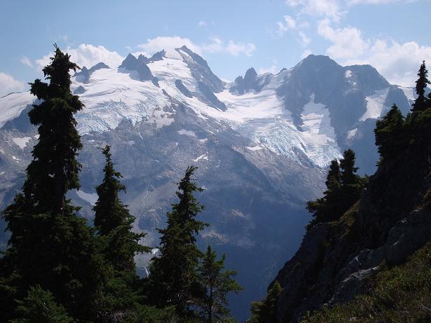
2 Cover photo: View of Mt. Ossa and Pelion from the Conservancy.
3 Esté-tiwilh/Sigurd Creek Conservancy Management Plan Approved by:
4
5 Acknowledgements The Squamish ation and BC Parks jointly prepared this management plan. The management planning process was coordinated by Vicki Haberl, Regional Planning Section Head, BC Parks, Ministry of Environment. Bryan Evans of Dovetail Consulting Inc. prepared management plan drafts for review by BC Parks and the Squamish ation, under contract to BC Parks. The Squamish ation and BC Parks would like to thank those who took the time to provide comments on this conservancy management plan. Esté-tiwilh/Sigurd Creek Conservancy i
6 Table of Contents Acknowledgements... i 1.0 Introduction Management Plan Purpose Planning Area Legislative Framework Management Commitments Planning Process Roles and Values of the Conservancy Significance and Role in the Protected Areas System Cultural Heritage Biological Diversity and atural Environment Recreation Development and Use of atural Resources Management Direction Vision Management Objectives and Strategies Zoning Plan Implementation Collaborative Relationship Management Strategies Future Planning Appendix A Appropriate Uses Table Figure 1: Regional Context Map... 4 Figure 2: Esté-tiwilh/Sigurd Creek Conservancy Map... 5 Esté-tiwilh/Sigurd Creek Conservancy ii
7 1.0 Introduction 1.1 Management Plan Purpose The purpose of this management plan is to guide the management of the Esté-tiwilh/Sigurd Creek Conservancy. The management plan: establishes long-term strategic direction for the conservancy; sets out a vision for the future state of the conservancy; addresses current issues affecting that long-term vision; guides management of the natural environment; identifies social, ceremonial and cultural uses by the Squamish ation; defines appropriate levels and types of recreational activities and the location and kinds of facilities that will be developed to accommodate those uses; and identifies acceptable uses of the conservancy s natural resources. 1.2 Planning Area The Esté-tiwilh/Sigurd Creek Conservancy is approximately 1,112 hectares in size and is adjacent to the northern boundary of Tantalus Park in southwestern British Columbia. The conservancy represents approximately 12% of the 9,164 hectare Esté-tiwilh Kwékwayex Kwelháynexw ta Skwxwú7mesh Temixw, or Squamish ation Wild Spirit Place, on the west side of the Squamish River between the Ashlu and Elaho watersheds (See Figures 1 and 2). The conservancy is also adjacent to Yelhixw, a Squamish ation village site, at the confluence of the Squamish River and Ashlu Creek. 1.3 Legislative Framework The Esté-tiwilh/Sigurd Creek Conservancy was established in 2008, under Schedule E of the Protected Areas of British Columbia Act. The management and development of Esté-tiwilh/Sigurd Creek Conservancy will be based upon land use and collaborative management agreements between British Columbia and the Squamish ation (as described below), the Protected Areas of British Columbia Act, the Park Act, the Park, Conservancy and Recreation Area Regulation. Esté-tiwilh/Sigurd Creek Conservancy 1
8 Conservancies are set aside for four reasons: (a) (b) (c) (d) The protection and maintenance of their biological diversity and natural environments; The preservation and maintenance of social, ceremonial and cultural uses of First ations; The protection and maintenance of their recreational values; and To ensure that development or use of their natural resources occurs in a sustainable manner consistent with the purposes of paragraphs (a), (b) and(c). Sections 8 and 9 of the Park Act direct that any interest in land and most uses of a natural resource in a conservancy must be authorized by a park use permit. A park use permit can only be issued if the use or activity will not restrict, prevent or inhibit the development, improvement or use of the conservancy in accordance with (a), (b), (c) and (d) above. The Park Act further states that a park use permit must not be issued to authorize commercial logging, mining, or hydro electric power generation, other than local run-of-the-river projects. "Local run-of-the-river projects", in relation to a conservancy, means hydro power projects supplying power for use (a) in the conservancy, or (b) by communities, including First ation communities, that do not otherwise have access to hydro electric power. 1.4 Management Commitments The Esté-tiwilh/Sigurd Creek Conservancy is within the traditional territory of the Squamish ation. In 2001, the Squamish ation completed their land use plan, Xay Temixw: Sacred Land. The Squamish ation land use plan identified several areas in Squamish ation traditional territory to be set aside as protected areas, called Kwékwayex Kwelháynexw ta Skwxwú7mesh Temixw, also known as Squamish ation Wild Spirit Places. In June 2007, the Squamish ation and British Columbia entered into the Agreement on Land Use Planning between the Squamish ation and the Province of British Columbia. Under the agreement, the Province agreed to establish new protected areas, including Esté-tiwilh/Sigurd Creek Conservancy. The agreement sets out the purposes and objectives for the conservancy, as follows: The primary objectives for the conservancy shall be the protection and maintenance of the biological diversity and natural environments, including wildlife habitat values, the preservation and maintenance of social, ceremonial and cultural uses by the Squamish ation, and the protection and enhancement of any cultural and heritage resources. The conservancy will be collaboratively managed between the Province, pursuant to the Park Act, and the Squamish ation, pursuant to its equivalent Squamish ation legislative or administrative mechanisms, through a Collaborative Management Agreement to be entered into between British Columbia and the Squamish ation. Industrial logging, mining, hydro-electric development, new roads, and commercial development in the conservancy are prohibited. Squamish ation and British Columbia may, by mutual agreement, identify development activities that they will recommend are acceptable uses within the conservancy. Esté-tiwilh/Sigurd Creek Conservancy 2
9 In June 2007, the Squamish ation and British Columbia entered into a Collaborative Agreement for the Management of Protected Areas in Squamish ation Traditional Territory to promote collaboration and communication between them in the management and planning of protected areas in Squamish ation traditional territory. The 2008 Sea-to-Sky Land and Resource Management Plan and the land use planning agreement provide high-level direction for land use in the conservancy and on adjacent lands. The development of this management plan has been guided by, and is consistent with, the Agreement on Land Use Planning between the Squamish ation and the Province of British Columbia and the collaborative management agreement. Where there is an inconsistency between this management plan, the land use planning agreement and the collaborative management agreement, the latter two will take precedence. 1.5 Planning Process The Esté-tiwilh/Sigurd Creek Conservancy falls within the traditional territory of the Squamish ation. Under the collaborative management agreement, the parties have committed to joint development and/or review of protected area management plans. BC Parks and the Squamish ation have jointly developed this conservancy management plan consistent with the collaborative management agreement. A Terms of Reference jointly developed by BC Parks and the Squamish ation has guided this conservancy management planning process. Bryan Evans of Dovetail Consulting Inc. prepared management plan drafts with input from BC Parks and Squamish ation representatives. Following completion of a complete first draft, agency, stakeholder and other First ation review of this management plan was undertaken. The draft management plan was posted online for public comment with notification in the local papers. Copies were also made available to the public at several local libraries, including in Squamish and orth Vancouver. Revisions to the management plan were made as necessary to reflect comments received on the draft management plan. Esté-tiwilh/Sigurd Creek Conservancy 3

10 Figure 1: Regional Context Map Esté-tiwilh/Sigurd Creek Conservancy 4

11 Figure 2: Esté-tiwilh/Sigurd Creek Conservancy Map Esté-tiwilh/Sigurd Creek Conservancy Management Plan 5
12 2.0 Roles and Values of the Conservancy 2.1 Significance and Role in the Protected Areas System The Esté-tiwilh/Sigurd Creek Conservancy contributes to the protection of cultural features and landscapes of importance to the Squamish ation. The primary role of the conservancy is to protect an important area identified by the Squamish ation as a Kwékwayex Kwelháynexw ta Skwxwú7mesh temixw, or Squamish ation Wild Spirit Place. The conservancy also: complements the existing Tantalus Park by protecting an additional 1,100 hectares and completing the protection of the Sigurd Creek watershed; protects known secure routes for Grizzly Bear from spring/summer forage locations to the salmon forage locations on the Squamish River floodplain; contributes to protection of habitat for species such as American Black Bear, Elk, Black-tailed Deer, Cougar, Mountain Goat, Grey Wolf, Grizzly Bear and Wolverine; contains some mid and high elevation old-growth forests; and, provides for public enjoyment and recreation. As is stated in the Agreement on Land Use Planning between the Squamish ation and British Columbia, the primary objectives for the conservancy are the protection and maintenance of the biological diversity and natural environments, including wildlife habitat values; the preservation and maintenance of social, ceremonial and cultural uses by the Squamish ation; and, the protection and enhancement of any cultural and heritage resources. 2.2 Cultural Heritage The conservancy is one component of the larger Squamish ation Esté-tiwilh Wild Spirit Place WSP, identified in the Squamish ation s land use plan, Xay Temixw: Sacred Land (2001). Wild Spirit Places were identified and designated for the purpose of protecting pristine landscapes for their natural qualities and for the continuation of Squamish ation cultural practices and traditional resource harvesting activities that depend on remoteness, naturalness and solitude. Traditional use in the Sigurd Creek watershed specifically is not well documented although it is well known that Squamish ation hunters accessed higher elevation forests and mountains in the area to hunt, especially for Black-tailed Deer and Mountain Goat. Mountains and higher elevation lakes and forests are important landscapes for cultural journeys and spiritual quests, and are used for training Squamish ation youth in traditional cultural practices. Skwxwú7mesh Chiyaxw represents Squamish ation traditional laws governing lands and resource use and management, as well as Squamish ation cultural and spiritual uses. Skwxwú7mesh Chiyaxw will guide Squamish ation members cultural and traditional renewable resource harvesting activities in the conservancy. Esté-tiwilh/Sigurd Creek Conservancy Management Plan 6
13 Cultural and traditional renewable resource harvesting activities include: gathering traditional Squamish ation foods; gathering plants used for medicinal and ceremonial purposes; hunting, trapping, and fishing; cutting selected trees for ceremonial or artistic purposes; conducting, teaching or demonstrating ceremonies of traditional, spiritual or religious significance; seeking cultural or spiritual inspiration; and, construction and use of shelters (such as camps and longhouses) essential to the pursuit of the above activities. 2.3 Biological Diversity and atural Environment Given its small size (1,112 hectares), the conservancy does not contribute significantly to representation of the ecological diversity of the region in the provincial protected areas system. The conservancy does contribute to protecting Sigurd Creek as an intact watershed, which is rare in southwestern British Columbia. The conservancy also adds to the regional scale biodiversity protection provided by the complex of adjacent or contiguous protected areas that includes Tantalus Park, Baynes Island Ecological Reserve, Brackendale Eagles Park and Skwelwil em Squamish Estuary Wildlife Management Area. Collectively, these areas represent 14,043 hectares of protected lands in the lower Squamish River watershed. Sigurd Creek and numerous smaller creeks drain east through the conservancy into the Squamish River. The terrain is steep with fast current flows, especially following periods of heavy precipitation. Fisheries values are considered low. Water quality and aquatic habitat information are not available for the conservancy at this time. The conservancy lies within the Southern Pacific Ranges Ecosection and contains portions of the Alpine, Mountain Hemlock and Coastal Western Hemlock biogeoclimatic zones. Vegetation in the conservancy is typical of these zones and ranges from alpine parkland to large coastal western hemlock and western redcedar stands. Most of the forests in the conservancy have been subject only to natural disturbance and are considered old-growth trees. Detailed vegetation inventory is not available for the conservancy area and it is therefore not feasible to identify whether rare or unique species, values or plant communities are present. There are no rare or endangered species or plant communities identified within the conservancy by the Conservation Data Centre (CDC). However, it is possible that due to the old-growth values of the conservancy that rare or unique values and plant communities may occur here. The conservancy contributes to or contains the habitat requirements for species associated with its three biogeoclimatic zones in coastal British Columbia. These species include Grizzly Bear, American Black Bear, Grey Wolf, Wolverine, Mountain Goat, Elk, and Black-tailed Deer. Other species such as Tailed Frog, Spotted Owl, and Marbled Murrelet may also occur within the conservancy. Portions of Esté-tiwilh/Sigurd Creek Conservancy Management Plan 7
14 the eastern slopes of Tantalus are recognized as potential Spotted Owl and Marbled Murrelet habitat, which may extend into Sigurd Creek and the conservancy. Some of the species mentioned above are red or blue listed by the Committee on the Status of Endangered Wildlife in Canada (COSEWIC). Many of the wildlife species will utilize habitat both within and outside the conservancy, and adjacent Tantalus Park. Management of wildlife values will, therefore, need to be based on cross-boundary values. 2.4 Recreation The Esté-tiwilh/Sigurd Creek Conservancy, and the adjacent areas within Tantalus Park, offer opportunities for hiking, backcountry camping, mountaineering, and backcountry skiing. The conservancy enhances the recreational and tourism values of the adjacent Tantalus Park by providing additional protected landscapes and alternative backcountry access to the northern portions of the park. It also contributes to the collective tourism values within the Sea-to-Sky Corridor and the communities of Squamish and Whistler. The conservancy is within easy access of the town of Squamish, the Resort Municipality of Whistler, and the heavily populated areas of the Lower Mainland. The conservancy provides hiking access on the Sigurd Creek Trail through an undeveloped old-growth forested valley. The Sigurd Creek trail provides access to a route up Sigurd Peak, as well as scenic viewpoints of the Squamish River valley, and the impressive Crooked Falls. The Sigurd Creek Trail also connects with a trail leading into the Pelion and Ossa Mountains area within Tantalus Park. This is one of the popular mountaineering areas of the park. The Sigurd Creek Trail is currently a rough trail, offering the opportunity for trail improvements, and potential trail connections to the Pokosha Creek area, and to Sigurd Lake. There is a commercial recreation licence for heli-hiking, held by Blackcomb Helicopters Limited Partnership (Land file # ); the tenure term expires in The Ministry of Environment and Squamish ation support the phasing out of this tenure to preserve a remote backcountry experience in the conservancy. The current tenure holder does not have any objections to the phasing out of the tenure, as this area is not well utilised and will therefore not adversely impact their guiding operations. There is also a licence of occupation held by the Canadian Outback Adventure Company Limited for river rafting (Land file ) on the Squamish River, which flows through the conservancy. 2.5 Development or Use of atural Resources There are two trapline licence areas overlapping the conservancy (ID# TR0206T006 and ID# TR0206T007). Other than recreation tenures and the use of the two existing trapline licence areas, there is no development nor use of natural resources within the conservancy. The conservancy is dedicated to conservation, cultural use, and low intensity backcountry recreation with limited infrastructure development. Low intensity, self-propelled recreational use will be allowed, consistent with maintaining the ecological and cultural values of the conservancy. o development of natural resources is appropriate in the conservancy. Esté-tiwilh/Sigurd Creek Conservancy Management Plan 8
15 3.0 Management Direction 3.1 Vision The Esté-tiwilh/Sigurd Creek Conservancy is managed in a manner that protects and maintains the wilderness qualities of the Sigurd Creek watershed. The conservancy provides a sanctuary for social, ceremonial and cultural uses by the Squamish ation, as well as for low impact backcountry recreational use and enjoyment of the public. The area is managed to minimize impacts to natural and cultural values, while offering opportunities to enjoy and appreciate those values. 3.2 Management Objectives and Strategies This section compiles the management issues, objectives, and strategies for the conservancy. See also Appendix A (Appropriate Uses Table). Issues, Stressors and/or Opportunities Squamish ation has an interest in continuing with their cultural uses and traditional resource harvesting activities in the conservancy. Objective Strategies Priority Protect the natural values and aesthetic qualities that support the cultural use and traditional resource harvesting activities of First ations. Maintain ongoing communications and working relationships with the Squamish ation consistent with the collaborative management agreement. Promote and enable traditional activities by present and future generations of the Squamish ation. Work in a co-operative manner with agencies involved in adjacent land use and development to incorporate appropriate management considerations for protection of conservancy values. Ensure any proposed developments or facilities (e.g., Squamish ation camp or cabin) in the conservancy are aesthetically pleasing, culturally appropriate and blend with the natural environment. BC Parks will advise Squamish ation if guided hunting is proposed in the conservancy. H Esté-tiwilh/Sigurd Creek Conservancy Management Plan 9
16 Issues, Stressors and/or Opportunities The small size of the conservancy requires the conservancy s ecological processes to be managed in conjunction with other adjacent lands and with the cooperation of other agencies. An increased understanding of the cultural importance of the area will enhance the visitor experience and help with the protection of cultural values. Objective Strategies Priority Maintain natural ecological processes. Build support and understanding of the cultural and conservation values of the conservancy. Ensure any new trails or trail upgrades are sensitive to the critical habitats and requirements of wildlife. Review the Tantalus Park fire management plan and revise as required to include the conservancy. Work in a co-operative manner with other agencies to manage biodiversity values that extend across conservancy boundaries. Encourage agencies to adopt management techniques that will not adversely impact conservancy values (e.g., habitat values for Grizzly Bears). Work in a co-operative manner with agencies, organizations and individuals to identify, research and monitor wildlife, particularly rare or endangered species, wildlife habitats or plant communities. Work in a co-operative manner with other agencies to manage conservation, recreation and cultural values that extend beyond conservancy boundaries. Encourage agencies to adopt appropriate land management techniques that will not adversely impact conservancy values. Visitor information will identify the conservancy as a component of the larger Esté-tiwilh Kwékwayex Kwelháynexw ta Skwxwú7mesh Temixw (Squamish ation Wild Spirit Place). The conservancy will be included in standard BC Parks information brochures, maps and website as well as through Squamish ation communication materials. All signage and communication materials should reflect the collaborative management of the conservancy by the Squamish ation and BC Parks and have a branding as a Squamish ation Kwékwayex Kwelháynexw ta Skwxwú7mesh Temixw (Squamish ation Wild Spirit Place). Where appropriate, Squamish ation language should be included in communication materials. Interpretive themes will focus on the remote, undisturbed qualities of the Sigurd Creek valley and the importance of the area for First ation cultural uses as a Squamish ation Kwékwayex Kwelháynexw ta Skwxwú7mesh Temixw (Squamish ation Wild Spirit Place) as well as the value of the area for backcountry recreation dependent on a pristine environment. H H Esté-tiwilh/Sigurd Creek Conservancy Management Plan 10
17 Issues, Stressors and/or Opportunities Water quality in the conservancy is free from contaminants and pollution. Current levels of facilities and use enable a wilderness oriented recreation experience. A significant increase in visitors or infrastructure may impact on these backcountry experiences. Some pre-existing tenures and future tenures may not be consistent with the vision for the conservancy. Objective Strategies Priority Maintain freshwater systems in their natural condition free from contaminants or pollution. Provide backcountry hiking and skiing opportunities and associated facilities to maintain a wilderness experience. Ensure that resource use tenures protect the conservation, cultural and recreational values within the conservancy. Ensure sanitary facilities (e.g., pit toilets) are properly designed, located and managed within the conservancy. Ensure any conservancy developments are constructed and maintained so as to minimize soil erosion and surface water flow. Provide the public with information on minimizing impacts to water quality in the backcountry. Prohibit fish stocking in alpine or sub-alpine lakes. Maintain, and, if necessary, improve the existing Sigurd Creek Trail. Consider future development of trail connections to Sigurd Lake and to Pokosha Creek. Monitor recreation use and, where necessary, take steps to manage the type, amount and location of recreation activities where, in the opinion of BC Parks and the Squamish ation, the aesthetic, cultural and/or ecological values of the conservancy are being negatively impacted. Do not actively promote use and visitation to the conservancy, other than road access signage. Appropriate highway signage will be provided to clarify road access to the conservancy. Signage within the conservancy will be minimized, other than at the trailhead and/or parking lot access. Prohibit the construction of backcountry recreational huts, shelters or cabins. Consider developing wilderness campsites. Cultural infrastructure may be developed, e.g., Squamish ation camp or marker poles. When the current heli-hiking tenure term comes up for renewal, BC Parks and the Squamish ation will work with the tenure holder to consider whether the tenure may be extended, amended or excluded based on whether the use is consistent with the management intent for the conservancy. Regulatory changes to prohibit aircraft landings may be recommended. Encourage trail maintenance with local stewardship groups. Retain self-propelled (non-motorized) recreation tenure (i.e., commercial rafting tenure). When the current heli-skiing tenure term is complete, recommend that the tenure not be renewed. o development of natural resources is appropriate in the conservancy. M M M Esté-tiwilh/Sigurd Creek Conservancy Management Plan 11
18 3.3 Zoning The entirety of Esté-tiwilh/Sigurd Creek Conservancy is zoned as a Cultural Zone to protect landscapes that are important for First ation s cultural values and uses. Low impact, non-mechanized and nonmotorised recreation is compatible with this zone type. Esté-tiwilh/Sigurd Creek Conservancy Management Plan 12
19 4.0 Plan Implementation 4.1 Collaborative Relationship Squamish ation and BC Parks will work together to plan, administer and manage the conservancy through application of the laws, policies, and regulations under the Park Act, relevant Squamish ation policies, and consistent with the Collaborative Agreement for the Management of Protected Areas in Squamish ation Traditional Territory. 4.2 Management Strategies The strategies are listed by priority in section 3.3. Implementation of these actions is dependent upon the availability of BC Parks and Squamish ation financial and staff resources, and will be affected by the needs of other parks and protected areas in the region. Approval of this management plan does not constitute approval of funding for implementation. In addition, BC Parks and Squamish ation may seek corporate, community or interagency partnerships to implement many of the actions in this management plan. 4.3 Future Planning In order to ensure the management of Esté-tiwilh/Sigurd Creek Conservancy remains relevant and effective, an adaptive management approach will be used. Adaptive management involves a five-step process of planning, action, monitoring, evaluation and revision of the management plan to reflect lessons learned, changing circumstances and/or objectives achieved. Adaptive management is flexible, collaborative, and responsive to public input. The management plan will be reviewed as required by the Squamish ation and BC Parks. Although no specific future planning is envisioned beyond the term of this management plan, BC Parks and Squamish ation will coordinate the review of the management plan as required. A review of the management plan should generally be triggered by the complexities of the management issues in the protected area and/or a significant change in circumstances (e.g., a natural disaster, major environmental change or discovery of a major new archaeological site), and not a by a specific time period. A management plan review looks for any necessary updates to the management plan that: are required to keep management direction current and relevant; correct the intent of a policy statement; address some error or omission; or, address a new proposal. Any updates or changes to the content of the management plan will be addressed through a formal management plan amendment process. The amendment process will include an opportunity for public input. Currently, Squamish ation is involved in treaty negotiations with senior levels of government. Squamish ation s contributions to this management plan are recognized and understood to be without prejudice to future treaty negotiations. Once formal treaty agreements have been reached with the Squamish ation, this management plan will be reviewed to determine whether it is in compliance with treaty. If it is not in compliance, then this management plan will be revised Esté-tiwilh/Sigurd Creek Conservancy Management Plan 13
20 accordingly. Changes will be made through an open public review process to build understanding of what these changes mean to the conservancy and its use. Esté-tiwilh/Sigurd Creek Conservancy Management Plan 14
21 Appendix A Appropriate Uses Table Activity/Use/Facility First ation Traditional Use 1 Hunting Fishing Trapping Horse Use/ Pack Animals Mountain Biking Guide Outfitting (hunting) Guide Outfitting (fishing) Guide Outfitting non mechanised (mountaineering, backpacking) Cat-Assisted Skiing Heli-skiing Heli-hiking Commercial Recreation (facility-based) Backcountry Huts Fish Stocking and Enhancement Road Access Off-road Access (snowmobiling) Off-road Access (motorised) Motorised Water Use Recreational Aircraft Access Commercial Aircraft Access Commercial Filming Appropriateness Y Y Y Y Y Y Y Y Legend Y ot an appropriate use in this zone May be an appropriate use in this zone It has been confirmed during the management planning process that this use is not appropriate in this zone. This may be an existing use which the management planning process has identified as no longer an appropriate use in this zone. The management plan details strategies for addressing this use (e.g., phasing out, closing). This indicates that some degree or scale of this use may be appropriate. For existing uses, the management plan will provide guidance on the appropriate level or scale of this use (e.g., direction to reduce, restrict or increase the current level of this activity) and may address specific restrictions or enhancements (e.g., capacity, appropriate sites, designated trails, purposes, party size, time of year, etc.). For new or expanded uses, this does not constitute approval. This indicates that the use may be considered for further evaluation and possible approval (e.g., park use permit adjudication, completion of a review as part of the BC Parks Impact Assessment Process). In some cases the appropriateness may not be confirmed until further assessments are completed. 1 Traditional use includes gathering traditional foods; gathering plants used for medicinal and ceremonial purposes; hunting, trapping, and fishing; cutting selected trees for ceremonial or artistic purposes; conducting, teaching or demonstrating ceremonies of traditional, spiritual or religious significance; seeking cultural or spiritual inspiration; and, construction and use of shelters (such as camps and longhouses) essential to the pursuit of the above activities. Esté-tiwilh/Sigurd Creek Conservancy Management Plan 15
Appendices. Contents. Appendices - Sep 1997 CP-1 AP-1
 Appendices Contents 1. Goals for Protected Areas in British Columbia... AP-3 2. Guiding Principles for Protected Areas... AP-4 3. Resource and Recreation Use Guidelines for Protected Areas... AP-5 4. Aboriginal
2.0 REGULATORY CONTEXT
 2.0 REGULATORY CONTEXT 2.1 CEAA and BC Parks Cooperation This Environmental Assessment Report (EAR) reflects the Terms of Reference for a Screening Report under the Canadian Environmental Assessment Act
TERMS OF REFERENCE MALASPINA COMPLEX COASTAL PLAN
 TERMS OF REFERENCE MALASPINA COMPLEX COASTAL PLAN A. RATIONALE Land and Water BC, resource user groups and the Powell River Regional District have requested that the Ministry of Sustainable Resource Management
Describing the Integrated Land Management Approach
 Describing the Integrated Land Management Approach ISBN No. 978-0-7785-8902-0 (Online Edition) Pub No. I/422 What is Integrated Land Management? Integrated land management (ILM) is the strategic, planned
Monarch Mountain/A Xéegi Deiyi Conservancy. Management Plan
 Monarch Mountain/A Xéegi Deiyi Conservancy Management Plan February 2016 Cover artwork: Wayne Carlick Foreword Tlingit Elders teach their people to work respectfully with all those who come to Taku River
Rocky Areas Project Guidance HABITAT
 Rocky Areas Project Guidance HABITAT Introduction Rocky habitats are surface areas dominated by exposed rock, such as mountain peaks, inland cliffs, buttes and rocky outcrops. In many cases, rocky areas
Gulf Islands National Park Reserve Management Plan Newsletter #3
 Management Plan Newsletter #3 P A R K S C A N A D A November 2011 Parks Canada is using a multi-phase planning process to develop the first management plan for the park. This newsletter provides a short
edmonton.ca/ribbonofgreen #ribbonofgreen
 WHAT IS THE RIBBON OF GREEN? The Ribbon of Green is Edmonton s entire river valley and ravine system. The Ribbon of Green (2018) Project will provide strategic guidance for the southwest and northeast
Regional Context Statement
 Regional Context Statement REGIONAL CONTEXT STATEMENT 3. REGIONAL CONTEXT STATEMENT In 1995, the Provincial Government passed into law the Growth Strategies Act. The purpose of this provincial initiative
An Introduction to the Far North Land Use Strategy
 An Introduction to the Far North Land Use Strategy December, 2013 Ministry of Natural Resources Table of Contents PREFACE... 3 About the Far North... 3 Evolution of Land Use Planning in the Far North...
It is based on: mutual respect between First Nations and the government of Ontario relationship building dialogue
 ONTARIO (FAR NORTH) 1. When did regional planning begin and describe why it began? Answers 1. To help ensure sustainable development, the Ontario government and First Nations are working together on community
A REGIONAL HERITAGE STRATEGIC PLAN for OKANAGAN - SIMILKAMEEN
 A REGIONAL HERITAGE STRATEGIC PLAN for OKANAGAN - SIMILKAMEEN The Regional District of Okanagan-Similkameen is preparing a Regional Heritage Strategic Plan. The Strategic Plan will identify important themes
I. STAFF POLICY RECOMMENDATIONS. The following RMP policy strategies are proposed by staff in support of a Scenic Resource Protection Program:
 Policy Consideration: Scenic Resource Protection Program Status: For Consideration by the Highlands Council at September 14, 2006 Work session Date: September 12, 2006 I. STAFF POLICY RECOMMENDATIONS The
This page intentionally blank.
 This page intentionally blank. Parks, Recreation, and Open Space Chapter Relationship to Vision Vision Parks, Recreation and Open Space Chapter Concepts County Government. County government that is accountable
April 11, 2016 Park Board Chair and Commissioners General Manager Vancouver Board of Parks and Recreation New Brighton Salt Marsh - Preferred Concept
 TO: FROM: SUBJECT: April 11, 2016 Park Board Chair and Commissioners General Manager Vancouver Board of Parks and Recreation New Brighton Salt Marsh - Preferred Concept RECOMMENDATION A. THAT the Vancouver
Lake O the Pines Master Plan Revision Public Information Meeting April 25 & 27, 2017
 Lake O the Pines Master Plan Revision Public Information Meeting April 25 & 27, 2017 Presented By Matthew Like, Lake Manager U.S. Army Corps of Engineers Fort Worth District US Army Corps of Engineers
Lewisville Lake Master Plan Revision Public Information Meeting May 2 & 4, 2017
 Lewisville Lake Master Plan Revision Public Information Meeting May 2 & 4, 2017 Presented By Rob Jordan Lake Manager U.S. Army Corps of Engineers Fort Worth District US Army Corps of Engineers Purpose
NORTHERN LANDS NORTHERN LEADERSHIP
 NORTHERN LANDS NORTHERN LEADERSHIP The GNWT Land Use and Sustainability Framework Our Lands, Our Interests, Our Future ii Land is Life MESSAGE FROM THE PREMIER Land is life. It is the link to our past.
Joe Pool Lake Master Plan Revision Public Information Meeting May 23, 2017
 Joe Pool Lake Master Plan Revision Public Information Meeting May 23, 2017 Presented By Jason Owen Lake Manager U.S. Army Corps of Engineers Fort Worth District US Army Corps of Engineers Purpose of this
Land Use Regional Planning in Alberta Collaborating with Stakeholders
 Land Use Regional Planning in Alberta Collaborating with Stakeholders Trevor Lema, Land & Integrated Management Planner September 2018 Overview Why Regional Planning? An Integrated Perspective Integrated
Sustainable Natural Environment Wetlands
 Town of Huntsville Official Plan Review - POLICY BACKGROUND PAPER Sustainable Natural Environment Wetlands BACKGROUND: Wetlands are an important natural resource. The ecological, social and economic benefits
TERRESTRIAL NATURAL HERITAGE SYSTEM STRATEGY APPENDIX F: MODEL POLICIES FOR THE IMPLEMENTATION OF THE TARGET TERRESTRIAL NATURAL HERITAGE SYSTEM
 TERRESTRIAL NATURAL HERITAGE SYSTEM STRATEGY APPENDIX F: MODEL POLICIES FOR THE IMPLEMENTATION OF THE TARGET TERRESTRIAL NATURAL HERITAGE SYSTEM C H A P T E R 1 M O D E L P O L I C I E S F O R I M P L
Concept Master Plan. for. Draft of. Wildlife Management Area. Prepared for. June, 2008
 Draft of Concept Master Plan for Vermillion Highlands: A Research, Recreation and Wildlife Management Area Prepared for Vermillion Highlands Steering Committee - Minnesota Department of Natural Resources
Appendix A. Planning Processes. Introduction
 1 Planning Processes Introduction This appendix outlines a number of planning processes which are used in the Auckland Region to support the effective management of development in the region s rural and
3-2 Environmental Systems
 3-2 Environmental Systems 3.0 ENVIRONMENTAL SYSTEMS CONTENTS 3.1 GREENWAY SYSTEM 3.1.1 General Policies 3.1.2 Natural Heritage Network 3.1.3 Natural Heritage Network Enhancement Lands 3.1.4 Rouge Watershed
THE CORPORATION OF THE CITY OF WINDSOR Office of the City Solicitor Planning Department
 THE CORPORATION OF THE CITY OF WINDSOR Office of the City Solicitor Planning Department REPORT TO THE CITY OF WINDSOR PLANNING ADVISORY COMMITTEE DATE OF REPORT: August 19, 2010 SUBJECT: Official Plan
STEWARDSHIP OF LONG ISLAND SOUND S ECOLOGICAL AND RECREATIONAL RESOURCES
 STEWARDSHIP OF LONG ISLAND SOUND S ECOLOGICAL AND RECREATIONAL RESOURCES Robin Kriesberg, Save the Sound, Inc. Thomas Halavik, US Fish and Wildlife Service Coastal Program An Initiative to Identify, Protect
4. What are the goals of the Kawarthas, Naturally Connected project? 7. What are watersheds and why are they being used as the project boundaries?
 Frequently Asked Questions (FAQs) 1. What are Natural Heritage Systems (NHS)? 2. Why are they important? 3. Which areas of the province have undertaken NHS projects? 4. What are the goals of the Kawarthas,
Heritage Management Plan
 Conrad Historic Site Heritage Management Plan This Management Plan represents the best efforts of the Carcross/Tagish First Nation and Yukon Governments to meet the requirements of the Carcross/Tagish
9 CITY OF VAUGHAN OFFICIAL PLAN AMENDMENT NO BOCA EAST INVESTMENTS LIMITED
 9 CITY OF VAUGHAN OFFICIAL PLAN AMENDMENT NO. 631 - BOCA EAST INVESTMENTS LIMITED The Planning and Economic Development Committee recommends the adoption of the recommendations contained in the following
Canyon Lake Master Plan Revision Public Information Meeting March 18, 2016
 Canyon Lake Master Plan Revision Public Information Meeting March 18, 2016 Marcus Schimank Canyon Lake Manager Capital Regional Office U.S. Army Corps of Engineers Fort Worth District US Army Corps of
Jonathan Sharpe, NL EHJV Program Manager
 Wildlife/Habitat Stewardship in Newfoundland and Labrador: The Stewardship Association of Municipalities i Inc. Wilson Hoffe SAM President Wilson Hoffe, SAM President Jonathan Sharpe, NL EHJV Program Manager
Call for Artists for: Design and Construction of Environmental Art Activation Story Mill Community Park, Bozeman, MT
 Call for Artists for: Design and Construction of Environmental Art Activation Story Mill Community Park, Bozeman, MT Seeking artists to design, fabricate and install art elements in the nature sanctuary
3. STATEMENTS OF DESIRED CHARACTER FOR PLANNING AREAS AND PRECINCTS
 3.30 Planning Area No. 30 Mary River Valley 3.30.1 Location and Role This Planning Area encompasses rural lands in the western part of the Shire. These lands are located within the catchment area of the
40 Years: A Brief History of Whistler - The Role of Long Term Planning Colorado Association of Ski Towns. January 20, 2016
 40 Years: A Brief History of Whistler - The Role of Long Term Planning Colorado Association of Ski Towns January 20, 2016 Presentation overview Whistler s unique history Building of Whistler Premise, purpose
Master Plan Objectives and Policies
 Master Plan Objectives and Policies Introduction This chapter identifies the Park issues and recommended policies established by this Master Plan. The issues were identified through meetings with staff,
THE FUTURE OF THE MCABEE FOSSIL BEDS HERITAGE SITE - Aligning the management of the site with fossil management approaches
 November 2014 A world class site with an interpretive and research centre that explores the role of fossils in our lives in a natural and cultural setting. PURPOSE The purpose of this document is to articulate
Staff will be providing an overview of the project need, purpose and intent for consideration as part of the Amendment cycle.
 Agenda Item D-2 City of Tacoma Planning and Development Services To: Planning Commission From: Stephen Atkinson, Planning Services Division Subject: Open Space Corridors Project Meeting Date: March 1,
3. VISION AND GOALS. Vision Statement. Goals, Objectives and Policies
 Vision Statement Queen Creek s interconnected network of parks, trails, open spaces and recreation opportunities provide safe and diverse activities and programs that sustain its unique, small town, equestrian
Town of Peru Comprehensive Plan Executive Summary
 Town of Peru Comprehensive Plan Executive Communities that plan grow by choice, not by chance. A plan makes growth thoughtful, understandable, and predictable. A plan shows that a community is managing
OFFICIAL COMMUNITY PLANS (OCPs) AND ZONING BYLAWS (ZBs): PLANNING FOR THE FUTURE
 AND ZONING BYLAWS (ZBs): PLANNING FOR THE FUTURE") OFFICIAL COMMUNITY PLANS (OCPs) AND ZONING BYLAWS (ZBs): PLANNING FOR THE FUTURE Official Community Plan Workshop January 20, 2016 Frontier, SK SARM Community Planning Services SARM the voice of rural
OFFICIAL COMMUNITY PLANS (OCPs) AND ZONING BYLAWS (ZBs): PLANNING FOR THE FUTURE Official Community Plan Workshop January 20, 2016 Frontier, SK SARM Community Planning Services SARM the voice of rural
Infrastructure, Development and Enterprise Services. Natural Heritage Action Plan (NHAP) Project Initiation
 Project Initiation") Staff Report To Service Area Committee of the Whole Infrastructure, Development and Enterprise Services Date Monday, March 6, 2017 Subject Natural Heritage Action Plan (NHAP) Project Initiation Report
Staff Report To Service Area Committee of the Whole Infrastructure, Development and Enterprise Services Date Monday, March 6, 2017 Subject Natural Heritage Action Plan (NHAP) Project Initiation Report
CHAPTER 1 Introduction
 CHAPTER 1 Introduction From sea to summit, Lane County covers almost 4,800 square miles of diverse Oregon landscape. Stretching from the Pacific Ocean through the Coastal Range, the Willamette Valley to
Objective: Resolution to recommend adoption of the Big Thompson Assessment to the Planning Commission
 Type of Meeting: Administrative Matters Name of requestor: Zac Wiebe - 619-4534, Kerri Rollins - 619-4577, Gary Buffington - 619-4560 Department: Natural Resources Preferred appearance date: 8/18/2015
Preface. Erie. Scranton. Allentown. Pittsburgh. Harrisburg. Philadelphia
 The Southern Alleghenies Region The Southern Alleghenies Region spans the Laurel Highlands and Allegheny Front in the west across the Appalachians to the east. It is comprised of Blair, Bedford, Cambria,
PARKS AND RECREATION
 PARKS AND RECREATION WHAT YOU WILL FIND IN THIS CHAPTER: Background information on the development of the Park, Recreation, and System Plan (PRSP). General overview of Ellensburg s parks and recreation
Green Infrastructure. by Karen Engel, NYS DEC. NYS Department of Environmental Conservation
 Green Infrastructure by Karen Engel, NYS DEC What is Green Infrastructure? For some it s all about water Green Infrastructure techniques use soils and vegetation to infiltrate, evapotranspirate, and/or
SONOMA LOCAL AGENCY FORMATION COMMISSION
 For accessibility assistance with any of the following documents, please contact Sonoma LAFCO at (707) 565-2577 or email us at cynthia.olson@sonoma-county.org. SONOMA LOCAL AGENCY FORMATION COMMISSION
HALIFAX GREEN NETWORK PLAN
 HALIFAX GREEN NETWORK PLAN Community Planning & Economic Development Standing Committee June 21, 2018 Photo credit: Vlastimil Koutecky, Flickr Creative Commons HGNP PROCESS PHASE 1 FOUNDATIONS PHASE 2
Resource and Recreation Use Guidelines for Protected Areas. for. A Protected Areas Strategy. British. Columbia. areas. August 1995
 "LEARNING TO MANAGE FOR ECOLOGICAL INTEGRITY" A Protected Areas Strategy for British. Columbia Resource and Recreation Use Guidelines for Protected Areas August 1995 areas Province of British Columbia
Member Service Plan Sierra Nevada AmeriCorps Partnership
 Member Service Plan Sierra Nevada AmeriCorps Partnership Service plans lay the framework for what each Member will be doing during their service. Service plans detail the major projects and expected results
TREASURE COAST REGIONAL PLANNING COUNCIL M E M O R A N D U M. To: Council Members AGENDA ITEM 5H
 TREASURE COAST REGIONAL PLANNING COUNCIL M E M O R A N D U M To: Council Members AGENDA ITEM 5H From: Date: Subject: Staff October 17, 2008 Council Meeting Local Government Comprehensive Plan Review Draft
APPENDIX L3. Table of Contents. SWP EA Information Sheets
 E N V I R O N M E N T A L A S S E S S M E N T APPENDIX L3 SWP EA Information Sheets Table of Contents EA Info Sheet 1... L3-1 EA Info Sheet 2... L3-3 EA Info Sheet 3... L3-5 EA Info Sheet 4... L3-7 SCARBOROUGH
Public Information Meeting
 Lavon Lake Master Plan Revision Public Information Meeting March 10, 2015 Presented By Michael Kinard Lake Manager U.S. Army Corps of Engineers Fort Worth District US Army Corps of Engineers Purpose of
VANCOUVER ISLAND HIGHWAY AGREEMENT
 November 12, 1998 VANCOUVER ISLAND HIGHWAY AGREEMENT AN IMPLEMENTATION AGREEMENT BETWEEN THE PROVINCE OF BRITISH COLUMBIA, THE REGIONAL DISTRICT OF NANAIMO, THE CITY OF NANAIMO The CITY OF PARKSVILLE and
PSRC REVIEW REPORT & CERTIFICATION RECOMMENDATION
 PSRC REVIEW REPORT & CERTIFICATION RECOMMENDATION KITSAP COUNTY COUNTYWIDE PLANNING POLICIES July 2, 2012 BACKGROUND A major emphasis of the Washington State Growth Management Act (GMA) is the need to
UPPER BRODHEAD CREEK PARADISE CREEK GREENWAY PLAN
 UPPER BRODHEAD CREEK PARADISE CREEK GREENWAY PLAN The Upper Brodhead & Paradise Creeks Greenway Cooperating Municipalities Mount Pocono Borough Paradise Township Barrett Township Price Township Funding
systems is available on the Colorado Wetland Information Center (CWIC) website.
 website.") Colorado Natural Heritage Program Wetland Program Plan -- Dec 2015 Status Update and Addendum -- The Colorado Natural Heritage Program (CNHP) developed a Wetland Program Plan (WPP) in 2010 for the planning
Colorado Natural Heritage Program Wetland Program Plan -- Dec 2015 Status Update and Addendum -- The Colorado Natural Heritage Program (CNHP) developed a Wetland Program Plan (WPP) in 2010 for the planning
Preliminary Management Recommendations for the proposed Sedona Verde Valley Red Rock National Monument
 Preliminary Management Recommendations for the proposed Sedona Verde Valley Red Rock National Monument The Monument shall be managed consistent with the values that underlie the designation as a National
Mountain Resort Community Success Factors: Whistler, Canada Case Study
 Mountain Resort Community Success Factors: Whistler, Canada Case Study Dr. Peter Williams Centre For Tourism Policy and Research Simon Fraser University, Vancouver, Canada North American Mountain Resort
SAN RAFAEL GENERAL PLAN 2040 INTRODUCTION AND OVERVIEW
 SAN RAFAEL GENERAL PLAN 2040 INTRODUCTION AND OVERVIEW Steering Committee Presentation February 14, 2018 Purpose of General Plan Guide land use and development decisions Coordinate transportation, infrastructure,
Master Plan for Preservation and Scenic Conservation (1995)
") 3.2 Master Plan for Preservation and Scenic Conservation (1995) The Master Plan for Preservation and Scenic Conservation was developed under the direction of the Guilford Preservation Alliance in the 1980s
3.2 Master Plan for Preservation and Scenic Conservation (1995) The Master Plan for Preservation and Scenic Conservation was developed under the direction of the Guilford Preservation Alliance in the 1980s
Chapter 5: Recreation
 Chapter 5: Recreation Introduction and Setting Recreational opportunities within Nevada County are varied, ranging from public parks with intensively used active recreational facilities, to vast tracts
North Oakville East Parks Facilities Distribution Plan. November, 2009
 North Oakville East November, 2009 POLICY CONTEXT 1) Purpose a) The purpose of this document is to be a guide for the location, configuration, design and development of the parks system for the North Oakville
SCC PRD (2016) COUNTY PARK MASTER PLAN
 COUNTY PARK MASTER PLAN") SCC PRD (2016) COUNTY PARK MASTER PLAN MASTER PLAN UPDATE PARKS AND RECREATION COMMISSION NOVEMBER 7, 2018 PURPOSE OF THE MASTER PLAN The Sanborn County Park Master Plan will provide the Department with
SCC PRD (2016) COUNTY PARK MASTER PLAN MASTER PLAN UPDATE PARKS AND RECREATION COMMISSION NOVEMBER 7, 2018 PURPOSE OF THE MASTER PLAN The Sanborn County Park Master Plan will provide the Department with
Town of Cobourg Heritage Master Plan. Statutory Public Meeting
 Town of Cobourg Heritage Master Plan Statutory Public Meeting April 25 th 2016 Presentation Overview 1. Introduction 2. Project background and schedule overview 3. Review of strategic direction content
CITY OF BEACON NOTICE TO LANDSCAPE ARCHITECTS GENERAL INFORMATION AND REQUEST FOR PROPOSALS
 CITY OF BEACON NOTICE TO LANDSCAPE ARCHITECTS GENERAL INFORMATION AND REQUEST FOR PROPOSALS The City of Beacon (the CITY) is issuing this Request for Proposals (RFP) for the selection of a landscape architect
One River Environmental Assessment. Welcome!
 One River Environmental Assessment Welcome! One River Environmental Assessment Welcome to the One River Environmental Assessment Public Information Centre. Please explore each presentation area to learn
Whitemarsh Comprehensive Plan Update: Housing & Land Use. Public Workshop #3: September 20, 2018
 Whitemarsh Comprehensive Plan Update: Housing & Land Use Public Workshop #3: September 20, 2018 Agenda Welcome Process Recap What We ve Heard The Plan Framework Review of Recommended Actions Land Use Housing
implementation r expression in landscape
 6 ubc okanagan implementation campus plan r expression in landscape 68 6 implementation campus plan sections The Campus Plan supports the academic mission, values and commitments of the University by providing
LU Encourage schools, institutions, and other community facilities that serve rural residents to locate in neighboring cities and towns.
 Application No. 891627: Comprehensive Plan Text Amendment - Rural School Policies - Amend policies consistent with State Legislation allowing schools in the rural area and extension of sewer service to
Connecting people to parks
 Connecting people to parks Introduction from the Governor It is up to all of us to ensure the conservation of our State s wonderful national parks, marine parks and other conservation reserves continues
1 Introduction. Chapter. In this chapter:
 Chapter 1 Introduction In this chapter: 1.1 A Snapshot of the Region 1.2 Towards a Sustainable Region 1.3 The Provincial Context 1.4 Purpose and Organization The Regional Municipality of York Official
Yellowstone to Yukon Conservation Initiative
 Yellowstone to Yukon Conservation Initiative Jodi Hilty jodi@y2y.net 403 678 1137 www.y2y.net Canada, US Size: 500,000 sq mile Page 1 of 6 Participants in coordinating the ongoing transboundary cooperation:
OPEN SPACE AND RECREATION
 OPEN SPACE AND RECREATION The Town celebrates and maintains the spectacular visual character of our Sonoran Desert setting and we value our open space, mountain views, washes, vegetation, and wildlife.
Albion Hills Conservation Area Master Plan. Public Information Session
 Albion Hills Conservation Area Master Plan Public Information Session 1 03.25.2014 Meeting Agenda 1. Project Introduction Property History Current Use Master Plan Process 2. Draft Vision Goals and Objectives
Municipal Development Plan. Summer Village of ROCHON SANDS. Bylaw #241-18
 Municipal Development Plan Summer Village of ROCHON SANDS Bylaw #241-18 TABLE OF CONTENTS PART ONE: BACKGROUND AND PURPOSE 3 SECTION 1: BACKGROUND 3 SECTION 2: GOALS AND POLICIES 3 PART TWO: PHYSICAL ENVIRONMENT
A Growing Community Rural Settlement Areas
 Town of Huntsville Official Plan Review - POLICY BACKGROUND PAPER A Growing Community Rural Settlement Areas BACKGROUND: In addition to the fully municipally-serviced Urban Settlement Area and the Hidden
Shell Upstream Americas Resource Use
 Resource Use Bethany Beale Sociologist, Golder Associates Ltd. David Blower Senior Archaeologist, Golder Associates Ltd. Copyright of SHELL CANADA FMFN Technical Review September-21-11 1 Fort McKay s Technical
1INTRODUCTION. Purpose of the Truckee Railyard Master Plan
 1INTRODUCTION Purpose of the Truckee Railyard Master Plan The purpose of the Truckee Railyard Master Plan is to capture and describe the Town s vision for the Railyard Area and to guide its future redevelopment.
TOWN OF BETHLEHEM OPEN SPACE CONSERVATION PLAN PUBLIC MEETING: OCTOBER 12, 2017
 TOWN OF BETHLEHEM OPEN SPACE CONSERVATION PLAN PUBLIC MEETING: OCTOBER 12, 2017 Welcome and Agenda 6:00 6:45: Open House, Part One 6:45 7:15: Presentation and Questions 7:15 8:00: Open House, Part Two
T O W N O F H I G H R I V E R
 T O W N O F H I G H R I V E R o p e n s p a c e p l a n The Town of High River, 30 minutes South of Calgary, still retains much of its distinctive small town character and provides residents with a high
FOREST SERVICE MANUAL NATIONAL HEADQUARTERS (WO) WASHINGTON, DC
 WASHINGTON, DC") Page 1 of 11 FOREST SERVICE MANUAL NATIONAL HEADQUARTERS (WO) WASHINGTON, DC FSM 2300 RECREATION, WILDERNESS, AND RELATED RESOURCE MANAGEMENT Amendment No.: 2300-2011-2 Effective Date: October 19, 2011
Page 1 of 11 FOREST SERVICE MANUAL NATIONAL HEADQUARTERS (WO) WASHINGTON, DC FSM 2300 RECREATION, WILDERNESS, AND RELATED RESOURCE MANAGEMENT Amendment No.: 2300-2011-2 Effective Date: October 19, 2011
Summary of Action Strategies
 Strategic Action Plan 6 Summary of Action Strategies Action Strategy Categories: 1. Organization and Management 2. Implementation 3. Marketing and Promotion This chapter summarizes all of the action strategies
OPEN SPACE CHAPTER 7: OVERVIEW. Preserve open space to protect natural resources, enhance character and provide passive recreation opportunities
 CHAPTER 7: OPEN SPACE OVERVIEW Ridgefield has made tremendous progress permanently preserving areas of town as open space. Open space preservation can serve many important purposes, including: protect
PUBLIC ART CALL LIONS GATE COMMUNITY CENTRE. For Expressions of Interest Submission Deadline: March 18, 2018 Project Value: $85,000(inclusive)
") LIONS GATE COMMUNITY CENTRE PUBLIC ART CALL For Expressions of Interest Submission Deadline: March 18, 2018 Project Value: $85,000(inclusive) LGCC EOI 1 LIONS GATE COMMUNITY CENTRE (LGCC) PUBLIC ART CALL
LIONS GATE COMMUNITY CENTRE PUBLIC ART CALL For Expressions of Interest Submission Deadline: March 18, 2018 Project Value: $85,000(inclusive) LGCC EOI 1 LIONS GATE COMMUNITY CENTRE (LGCC) PUBLIC ART CALL
Mendota Heights 2040 Comprehensive Plan Draft Vers
 4 Parks and Trails The City of Mendota Heights boasts a variety of recreational and open space opportunities. Few cities can claim access to regional trails, riverside and lakeside parks, scenic bluffs
Dalla Mountain Park Management Plan
 Dalla Mountain Park Management Plan Adopted by Durango City Council February 7, 2006 I. INTRODUCTION Dalla Mountain Park, located on the southwestern slope of Animas Mountain, is a 177.8 acre tract rich
APPENDIX 20-B. Visual Quality Assessment ENVIRONMENTAL ASSESSMENT APPLICATION AND ENVIRONMENTAL IMPACT STATEMENT
 APPENDIX 20-B Visual Quality Assessment IDM MINING LTD. RED MOUNTAIN UNDERGROUND GOLD PROJECT APPENDIX 20-B RED MOUNTAIN UNDERGROUND GOLD PROJECT VOLUME 8 APPENDIX 20-B VISUAL QUALITY ASSESSMENT Table
CITY OF VAUGHAN EXTRACT FROM COUNCIL MEETING MINUTES OF NOVEMBER 15, 2016
 Item 11, Report No. 38, of the Committee of the Whole, which was adopted without amendment by the Council of the City of Vaughan on November 15, 2016. Regional Councillor Di Biase declared an interest
COASTAL CONSERVANCY. Staff Recommendation March 25, 2004 LOS ANGELES GREEN VISION PLAN. File No.: Project Manager: Marc Beyeler
 COASTAL CONSERVANCY Staff Recommendation March 25, 2004 File No.: 04-014 Project Manager: Marc Beyeler RECOMMENDED ACTION: Authorization to disburse up to $50,000 to the University of Southern California
Parks, Trails, and Open space Element
 Parks, Trails, and Open space Element Parks, Trails, and Open Space element Parks, Recreation, and Open Space are important components of the quality of life desired by the residents of Elk Grove. This
Stock-Taking on Integrated Coastal Zone Management (ICZM) in the Black Sea IMPLEMENTATION AUDIT QUESTIONNAIRE 2010
 in the Black Sea IMPLEMENTATION AUDIT QUESTIONNAIRE 2010") Stock-Taking on Integrated Coastal Zone Management (ICZM) in the Black Sea IMPLEMENTATION AUDIT QUESTIONNAIRE 2010 PURPOSE The purposes of this questionnaire are: (a) to perform the policy, legal and institutional
Stock-Taking on Integrated Coastal Zone Management (ICZM) in the Black Sea IMPLEMENTATION AUDIT QUESTIONNAIRE 2010 PURPOSE The purposes of this questionnaire are: (a) to perform the policy, legal and institutional
Shared History, Shared Future
 Open Space is Shared History, Shared Future Builds upon past and current regional planning: PSP Action Agenda, Vision 2040, the Cascade Agenda, and Mountains to Sound Greenway The ROSS Approach Building
CITY CLERK. Parkland Acquisition Strategic Directions Report (All Wards)
") CITY CLERK Clause embodied in Report No. 10 of the, as adopted by the Council of the City of Toronto at its meeting held on November 6, 7 and 8, 2001. 10 Parkland Acquisition Strategic Directions Report
CITY CLERK Clause embodied in Report No. 10 of the, as adopted by the Council of the City of Toronto at its meeting held on November 6, 7 and 8, 2001. 10 Parkland Acquisition Strategic Directions Report
Resolution XII NOTING also that with the increasingly rapid urbanization, wetlands are being threatened in two principle ways:
 12 th Meeting of the Conference of the Parties to the Convention on Wetlands (Ramsar, Iran, 1971) Punta del Este, Uruguay, 1-9 June 2015 Resolution XII.10 Wetland City 1 Accreditation of the Ramsar Convention
City of Tacoma Planning and Development Services
 Agenda Item D-1 City of Tacoma Planning and Development Services To: Planning Commission From: Elliott Barnett, Planning Services Division Subject: Application #2014-08 Open Space Element Update Meeting
The Palisades Interstate Parkway and Henry Hudson Drive designated a New Jersey State Scenic Byway, 2005
 The Palisades Interstate Parkway and Henry Hudson Drive designated a New Jersey State Scenic Byway, 2005 What are scenic byways? How Did Scenic Byways Come About? National Scenic Byways Program Administered
Framework for Sustainable Recreation
 Framework for Sustainable Recreation USDA Framework for Sustainable Recreation Laurie Thorpe, USFS Rachel Franchina, USFS Robert Burns, WVU Service USDAForest Forest Service Presentation Outline USFS Framework
CALGARY: City of Animals Edited by Jim Ellis
 CALGARY: City of Animals Edited by Jim Ellis ISBN 978-1-55238-968-3 THIS BOOK IS AN OPEN ACCESS E-BOOK. It is an electronic version of a book that can be purchased in physical form through any bookseller