Proposed St. Vital Transmission Complex
|
|
|
- Edwina Hodge
- 6 years ago
- Views:
Transcription
 transmission lines to improve system reliability and accommodate the growth in demand for electricity in southern Manitoba.")

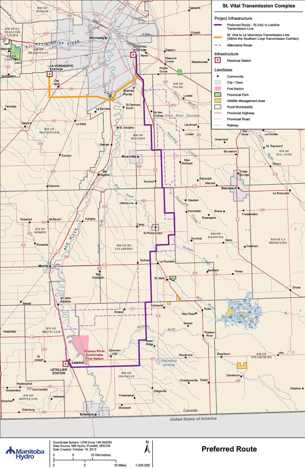
1 Proposed St. Vital Transmission Complex Round 2 Preferred Route for the St. Vital to Letellier Line What is it? Manitoba Hydro is proposing construction of two 230-kilovolt (kv) transmission lines to improve system reliability and accommodate the growth in demand for electricity in southern Manitoba. Both lines will originate at the St. Vital Station, located in southeastern Winnipeg. One line will run west to the La Verendrye Station, located near Oak Bluff. The other will run south to the Letellier Station, located near Letellier. The new transmission line between the St. Vital and La Verendrye stations will be situated on an existing Manitoba Hydro right-of-way, located south of Winnipeg, (see page 3) known as the Southern Loop. The transmission line between the St. Vital and Letellier stations will be routed through southeastern Manitoba, near Steinbach in order to accommodate a potential future 230-kV station. Manitoba Hydro is seeking public input to finalize a route for this line that will be submitted for regulatory approval. How do we choose a route for the St. Vital to Letellier line? Our approach to developing a preferred route for the St. Vital to Letellier transmission line includes early stakeholder input and takes into account engineering considerations as well as the built and natural environment. In the first round of public engagement, we shared information, including alternative routes, with landowners, First Nations, the Manitoba Métis Federation, municipalities and other stakeholders as well as the public. We received feedback on the alternative routes through stakeholder workshops, public open houses, meetings and and telephone communications. This included completed comment sheets, workbooks, mapped issues and concerns and route preferences. Route selection information was compiled from these sources, along with general comments from key person interviews, and used in development of the preferred route. In addition, discipline specialists evaluated cost, schedule, reliability and environmental considerations in determining the preferred route.
2 Project Timelines Round 1 - August Introduce the project Present alternative routes Answer questions Identify and document concerns Use input to guide preferred route selection process We are here. Round 2 - October / November Present findings of Round 1 Present the preferred route Answer questions Identify and document outstanding concerns Provide opportunity to discuss potential effects and possible mitigation measures to minimize effects Next steps Submission of the Environmental Assessment Report Regulatory authorities review report Receipt of licence Construction In-service for St. Vital to Letellier line: Fall 2016 Final project completion: 2017 The preferred route for the St. Vital to Letellier line The preferred route was determined by considering information supplied by specialists and feedback received throughout Round 1. Many alternative segments were presented by stakeholders, landowners and the general public. In total, four segments not initially presented during Round 1 are now considered part of the preferred route for the project. These have become part of the preferred route to address local concerns regarding aerial application, land use, current and future development, proximity to livestock operations and other concerns. We are seeking comments and feedback on the preferred route in order to refine it further. Upon completion of Round 2, we will file a final preferred route with Manitoba Conservation and Water Stewardship. What s next? Information gathered during round two of the public engagement process will assist in the identification of a final preferred route that balances technical, biophysical, and socioeconomic considerations. We will continue to: inform the public regarding the project, timelines and route selection process. utilize a variety of mechanisms to receive and share information with interested individuals. gather feedback on the local environment to help finalize the route as well as the environmental assessment. discuss mitigation measures to minimize potential impacts. provide the public with the opportunity to have their questions answered and concerns addressed by Manitoba Hydro representatives.
3 Tower Design For the St. Vital to La Verendrye transmission line, we will utilize a self-supporting steel lattice tower. These towers will be located on a 137 metre (m), (450 ft.) right-of-way and will vary in height from 30 to 40 m (98 to 131 ft.). They will be similar to existing transmission lines in the Sage Creek area of Winnipeg. For the St. Vital to Letellier transmission line, we will utilize a tubular steel H-frame structure. These towers will be located on a m (78 ft.) right-of-way when following a road or mile line, or 40 m (131 ft.) when placed in a field. These towers will vary in height up to 27 m (89 ft.), depending on terrain and road and river crossings. Typical Tubular Steel Structure* Typical cross-section of transmission line structure adjacent to road allowance Self Supporting Suspension Lattice Steel Structure* Typical cross-section of transmission line structure located on 1/4 section line * Tower height and design are estimations and are dependent on terrain and final placement of the transmission line. Southern Loop The Southern Loop is a dedicated transmission corridor that will accommodate the multiple transmission lines necessary to provide system reliability and to meet future energy demands. This corridor will reduce the number of independent rights-of-way on the landscape. Situated between the Dorsey Converter Station (located near Rosser) and Riel Station (located east of Winnipeg), this transmission corridor follows the western and southern boundaries of the City of Winnipeg. It connects to the LaVerendrye Station, which is near Oak Bluff. Sage Creek Transmission Corridor Cross section looking north Potential Future Existing 115kV Future 230kV LaVerendrye - St.Vital Future 230kV St.Vital - Letellier This cross section is based on matching existing tower locations and right-of-way width. The numbers (in metres) below the transmission lines indicate the complete right-of-way width for the transmission line in that area.
4
5 What we heard Round 1 Comment/Concern Potential impacts to aerial application. How was the feedback incorporated? Structure height in agricultural areas will be minimized to the extent possible to mimic heights of distribution lines. Air strip locations were identified, incorporated into early planning and avoided as much as possible in final route selection. Impacts to agricultural operations. We will avoid half-mile (quarter section) alignments where possible. Guyed-wire structures are not being considered for this project. A tubular steel H-frame design, which has a smaller footprint than self supporting or guyed structures, will be utilized. Potential affect on livestock, particularly dairy cattle, e.g., tingle voltage. Tingle voltage tends to occur with faulted distribution lines as opposed to transmission lines. Livestock operators are encouraged to contact Manitoba Hydro if they notice tingle voltage occurring so that the source can be identified. Loss of high-quality farm land. We will route the line adjacent to road allowances to minimize the land area used for the transmission line and the related impact on farming activities. Will I be compensated if the transmission line is on my land? Manitoba Hydro provides a one-time compensation payment for transmission line easements (75 per cent of market value), as well as one-time structure payment related to loss of annual production. We also compensate landowners for any damages which may occur through the construction and operation of the line. Proximity to farmsteads and shelterbelts. During routing, we avoid residences and shelterbelts as to the extent possible. Many areas are flood prone. The potential for flooding was taken into account but does not hinder operation of the transmission line. Locate transmission lines within existing Hydro transmission line corridors. This is being done where feasible; a portion of the line passing through Sage Creek is in an existing Manitoba Hydro corridor as is the Southern Loop. Locate transmission line infrastructure adjacent to linear infrastructure such as provincial and municipal highways and roads and drains in order to reduce land requirements. Existing corridors and linear features were identified as routing opportunities in the route selection process and are being taken advantage of where possible. We will consult with Manitoba Infrastructure and Transportation (MIT) on future planning before developing alignments near PTH 75, PTH 59 and PTH 52. Minimize transmission line crossings of major highways and rail lines, as well as stream crossings. Concern that stream crossings impact riparian habitat. Such crossings, which require higher and more costly towers, were minimized.
6 Comment/Concern Avoid landfills, lagoons and cemeteries. How was the feedback incorporated? Locations of landfills, lagoons and cemeteries were noted. Structure placement will avoid these areas. Transmission tower aesthetics. Towers that will be placed adjacent to existing towers will have similar spacing and heights. Potential impact on wildlife, including birds, vegetation, riparian area, endangered species and wetlands The environmental assessment process will identify potential environmental sensitivities and will prescribe appropriate mitigation measures. Concern that construction will disrupt fur-bearing animals and affect trapping. The environmental assessment process will identify potential sensitivities related to fur-bearing animals and will prescribe appropriate mitigation measures such as modifications to construction scheduling. Avoid heritage sites. The environmental assessment process will identify heritage resources, including archaeological sites, which will be avoided. Perceived health effects due to electric and magnetic fields (EMF). Information will continue to be provided in the public engagement process and these concerns will be addressed in the environmental assessment process. Health Canada, the World Health Organization, and other international health entities have noted that no scientific evidence suggests that exposure to EMF will cause any negative health effects on humans, vegetation and wild or domestic animals. Transmission line rights-of-way become areas for growth of noxious weeds and potential bio-security issues. We will take necessary precautions as part of construction of the project to minimize the risk of invasive plants and diseases spreading. Manitoba Hydro is currently developing a bio-security policy. Noise, dust and disruption of traffic, particularly related to emergency services, during construction. Construction operations will minimize noise and dust. Construction traffic routes and detours will be identified and made available to local police, fire and emergency services. City, municipal and business and industry stakeholders, in particular, noted beneficial effects of a more secure power supply on their operations and growth. Agricultural stakeholders also noted that they are impacted by electrical power system reliability. The beneficial effect on power system reliability and capacity is a fundamental reason for this project.
7 What happens after a final preferred route is selected? Following the determination of a preferred route and the filing of the environmental assessment report to Manitoba Conservation and Water Stewardship, we are planning to meet with affected landowners. These meetings will be held exclusively for affected landowners and will outline the following: Manitoba Conservation and Water Stewardship s public review process for the environmental assessment report submitted by Manitoba Hydro. Manitoba Hydro s compensation policy. What to expect during the land surveying process. What to expect throughout construction of the project. We encourage all affected landowners to attend this meeting to learn: How the project will unfold after Manitoba Hydro files the environmental assessment report. How to participate in the regulatory review process. What to expect once a project is licensed. The environmental assessment process The development of both transmission lines requires a Class 2 licence under The Environment Act (Manitoba). The environmental assessment report for the project includes: How can you participate? There are a number of ways you can participate in a review of this project and provide your input: Attend an open house You are invited to attend one of four open houses to gather project information and share your local knowledge. Your input will help us determine a final preferred route for the project. Manitoba Hydro and consultant staff will be available to provide project information and answer your questions. Refreshments will be provided. Dominion City November 4 Dominion City Community Hall 31 McKercher St. Ile des Chenes November 6 Trans Canada Centre 1 Rivard St. Submit a comment sheet, available at the open houses or on our website at Contact us directly: Winnipeg November 7 Winakwa Community Centre 980 Winakwa Road St. Pierre Jolys November 5 Cabane a Sucre 432 Joubert St. Trevor Joyal Licensing & Environmental Assessment Department Toll-free: In Winnipeg: LEAprojects@hydro.mb.ca Website: documentation of public engagement activities. characterization of the environment. identification of potential effects on people and the environment. determination of ways to avoid or reduce potential adverse effects.
Alternative Route Selection
 Alternative Route Selection Multiple routes are developed within the Alternative Corridors Developed by Project Team taking into account all information gathered to date Buildings St. Vital Station to
Alternative Routes. St. Vital to La Verendrye Station - Southern Loop Transmission Corridor. 20 different segments 4 segments common to all routes
 Alternative Routes St. Vital to La Verendrye Station - Southern Loop Transmission Corridor In a fixed right-of-way St. Vital to Letellier Station 20 different segments 4 segments common to all routes Goal
Alternative Routes Determined
 Alternative Routes Determined Preferred Route Selection Preferred Route Selection Expert judgment is used to determine the Final Preferred Route Takes into account feedback from Round One engagement and
Presentation August 20, 2013
 Presentation August 20, 2013 St. Vital Transmission Complex Stakeholder Workshop WELCOME! Manitoba Hydro 9:00am to 1:50pm Purpose of Workshop Share current project information Including outcomes of the
Inform you of the purpose and scope of the study for PTH 100 and a proposed future St. Norbert Bypass;
 WELCOME The intent of today s Open House is to: Inform you of the purpose and scope of the study for PTH 100 and a proposed future St. Norbert Bypass; Review highway crossing locations, future access closures
Rapid Transit Implementation Working Group September 14, 2017
 Rapid Transit Implementation Working Group September 14, 2017 BACKGROUND Council approved the Rapid Transit Master Plan and Updated Business Case on July 25, 2017. Approval of the RTMP confirmed the BRT
Rapid Transit Implementation Working Group
 Rapid Transit Implementation Working Group October 12, 2017 1 Agenda 1. Consultation Update 2. Technical Work Update 3. LTC Rapid Transit Integration 4. Next Steps 2 Consultation Update 3 Consultation
NORTHEAST RIVER CROSSING FUNCTIONAL PLANNING STUDY
 WELCOME Northeast River Crossing Functional Planning Study Phase 2 Public Meeting 4 to 8 PM Informal drop-in format and discussion tables Meeting Purpose Introduce the Northeast River Crossing Functional
CONSULTING SERVICES FOR THE WHITEBELT VISIONING EXERCISE ADDENDUM TO THE GTA WEST LAND USE STUDY WORK PROGRAM
 CONSULTING SERVICES FOR THE WHITEBELT VISIONING EXERCISE ADDENDUM TO THE GTA WEST LAND USE STUDY 1. Introduction WORK PROGRAM The Town of Caledon is a large, local municipality located in the Greater Toronto
Letter of Notification For East Lima Station Expansion Project
 Letter of Notification For East Lima Station Expansion Project PUCO Case No. 18-0906-EL-BLN Submitted to: The Ohio Power Siting Board Pursuant to Ohio Administrative Code Section 4906-6-05 Submitted by:
Application for Certificate of Environmental Compatibility and Public Need
 Application for Certificate of Environmental Compatibility and Public Need Central Hudson Gas & Electric A and C Lines Towns of Pleasant Valley, LaGrange, Wappinger, and East Fishkill Dutchess County,
AMENDMENT NO. 30 TO THE OFFICIAL PLAN OF THE TOWN OF MILTON
 AMENDMENT NO. 30 TO THE OFFICIAL PLAN OF THE TOWN OF MILTON Subject: Boyne Survey Secondary Plan and Related Official Plan Amendments The following text and schedules constitute Amendment No. 30 to the
Leaside to Main Infrastructure Refurbishment Project
 N6667_Leaside to Main Panels Feb 2016_Clarington Panels 16-02-01 3:22 PM Page 1 Leaside to Main Infrastructure Refurbishment Project Strengthening the transmission system in your neighbourhood N6667_Leaside
Vaughan Metropolitan Centre (VMC) Black Creek Renewal CLASS ENVIRONMENTAL ASSESSMENT
 Black Creek Renewal CLASS ENVIRONMENTAL ASSESSMENT") PUBLIC INFORMATION CENTRE Vaughan Metropolitan Centre (VMC) Black Creek Renewal Wednesday, May 10, 2017 6:00 p.m. to 8:00 p.m. Add photo Project Management, Environmental Assessment, Stormwater Management
PUBLIC INFORMATION CENTRE Vaughan Metropolitan Centre (VMC) Black Creek Renewal Wednesday, May 10, 2017 6:00 p.m. to 8:00 p.m. Add photo Project Management, Environmental Assessment, Stormwater Management
Project 6 All-Season Road Linking Manto Sipi Cree Nation, Bunibonibee Cree Nation & God s Lake First Nation
 Project 6 All-Season Road Linking Manto Sipi Cree Nation, Bunibonibee Cree Nation & God s Lake First Nation Possible Effects and Mitigation (Round 5) - Presentation to God s Lake Narrows March 24, 2017
COUNTY OF LAMBTON OFFICIAL PLAN UPDATE BACKGROUND REPORT NO.
 COUNTY OF LAMBTON OFFICIAL PLAN UPDATE BACKGROUND REPORT NO. 7 TELECOMMUNICATIONS Image Source: (Word Clip Art Stock Photos, 2011) Date: May, 2015 PLANNING AND DEVELOPMENT SERVICES DEPARTMENT 789 Broadway
Parks, Trails, and Open space Element
 Parks, Trails, and Open space Element Parks, Trails, and Open Space element Parks, Recreation, and Open Space are important components of the quality of life desired by the residents of Elk Grove. This
CALA Homes is preparing a planning application for a development of up to 36 new homes, including a mix of properties to meet local demand.
 WELCOME Welcome to this public consultation event for our proposed development on land to the south of Twelve Leys in Wingrave. Thank you for taking the time to come along today. Homes is preparing a planning
APPENDIX I Presentations
 APPENDIX I Presentations Workshop Summary Report 11 Peel Region Official Plan Review May 5, 2010 Compatible Active Recreation Workshop July 29, 2010 Components of PROPR Sustainability Planning Tools/Updates
Project 6 All-Season Road Linking Manto Sipi Cree Nation, Bunibonibee Cree Nation & God s Lake First Nation
 Project 6 All-Season Road Linking Manto Sipi Cree Nation, Bunibonibee Cree Nation & God s Lake First Nation The Environmental Assessment - Presentation to Bunibonibee Cree Nation December 8, 2016 Why are
Appendix A. Planning Processes. Introduction
 1 Planning Processes Introduction This appendix outlines a number of planning processes which are used in the Auckland Region to support the effective management of development in the region s rural and
APPENDIX F: EXTERNAL APPROVALS
 1.0 RESPONSIBILITIES When the City is constructing the Park or Open Space Development lands (OPTION I), after the subdivision construction process is completed by the Developer, Open Space Development
Canyon Lake Master Plan Revision Public Information Meeting March 18, 2016
 Canyon Lake Master Plan Revision Public Information Meeting March 18, 2016 Marcus Schimank Canyon Lake Manager Capital Regional Office U.S. Army Corps of Engineers Fort Worth District US Army Corps of
Cape Environmental Assessment Practitioners(Pty)
") BACKGROUND INFORMATION DOCUMENT (BID) Introduction Cape Environmental Assessment Practitioners(Pty) Ltd Reg. No. 2008/004627/07 Telephone: (044) 874 0365 First Floor, Eagles View Building Facsimile: (044)
BACKGROUND INFORMATION DOCUMENT (BID) Introduction Cape Environmental Assessment Practitioners(Pty) Ltd Reg. No. 2008/004627/07 Telephone: (044) 874 0365 First Floor, Eagles View Building Facsimile: (044)
Parks, Trails, and Open Space Element
 P arks, Recreation, and Open Space are important components of the quality of life desired by the residents of Elk Grove. This Element of the General Plan addresses the City s goals, policies, and actions
TERRESTRIAL NATURAL HERITAGE SYSTEM STRATEGY APPENDIX F: MODEL POLICIES FOR THE IMPLEMENTATION OF THE TARGET TERRESTRIAL NATURAL HERITAGE SYSTEM
 TERRESTRIAL NATURAL HERITAGE SYSTEM STRATEGY APPENDIX F: MODEL POLICIES FOR THE IMPLEMENTATION OF THE TARGET TERRESTRIAL NATURAL HERITAGE SYSTEM C H A P T E R 1 M O D E L P O L I C I E S F O R I M P L
PURPOSE OF MEETING MEETING GUIDELINES PROJECT BACKGROUND ESKOM CLOCOLAN-FICKSBURG 88 KV POWERLINE, FREE STATE
 ESKOM CLOCOLAN-FICKSBURG 88 KV POWERLINE, FREE STATE DRAFT BASIC ASSESSMENT REPORT PUBLIC REVIEW LANDOWNERS MEETING FICKSBURG 23 JULY 2013 T his project is being conducted on behalf of Eskom PRESENTATION
April Parker Lands Major Redevelopment Site Environmental Overview. Submitted to: Prepared by:
 April 2017 Parker Lands Major Redevelopment Site Environmental Overview Submitted to: 6165347 Manitoba Inc. 1383 Spruce Street Winnipeg, Manitoba R3E 2V8 Prepared by: EcoLogic Environmental Inc. Wildlife,
ROSEMONT 138KV TRANSMISSION LINE SITING STUDY PROJECT
 ROSEMONT 138KV TRANSMISSION LINE SITING STUDY PROJECT Public Open House Meeting #3 - Corona de Tucson April 14, 2010 - Quail Creek 5:30pm 8:30pm Presentation and Question and Answer: 6:30pm 7:00pm Project
DRAFT SECTION 4(f) EVALUATION INTERSTATE 73 FEIS: I-95 to I-73/I-74 in North Carolina
 EVALUATION INTERSTATE 73 FEIS: I-95 to I-73/I-74 in North Carolina") DRAFT SECTION 4(f) EVALUATION INTERSTATE 73 FEIS: I-95 to I-73/I-74 in North Carolina 1.0 INTRODUCTION Section 4(f) of the Department of Transportation Act of 1966, 49 U.S.C. 303, requires that prior to
DRAFT SECTION 4(f) EVALUATION INTERSTATE 73 FEIS: I-95 to I-73/I-74 in North Carolina 1.0 INTRODUCTION Section 4(f) of the Department of Transportation Act of 1966, 49 U.S.C. 303, requires that prior to
Lake O the Pines Master Plan Revision Public Information Meeting April 25 & 27, 2017
 Lake O the Pines Master Plan Revision Public Information Meeting April 25 & 27, 2017 Presented By Matthew Like, Lake Manager U.S. Army Corps of Engineers Fort Worth District US Army Corps of Engineers
Dorenell Wind Farm 132 kv Grid Connection
 Who We Are Scottish and Southern Energy Power Distribution is part of the SSE plc group of companies. We own, maintain and invest in the electricity networks in the north of Scotland the electricity transmission
I. STAFF POLICY RECOMMENDATIONS. The following RMP policy strategies are proposed by staff in support of a Scenic Resource Protection Program:
 Policy Consideration: Scenic Resource Protection Program Status: For Consideration by the Highlands Council at September 14, 2006 Work session Date: September 12, 2006 I. STAFF POLICY RECOMMENDATIONS The
Planning and Public Consultation Process for the Preparation of a General Land Use Plan for South Port Kells TERMS OF REFERENCE
 APPENDIX "B" Planning and Public Consultation Process for the Preparation of a General Land Use Plan for South Port Kells TERMS OF REFERENCE PURPOSE South Port Kells is located in the northeastern quadrant
SOUTHWEST TRANSITWAY (STAGE 2) PUBLIC OPEN HOUSE
 PUBLIC OPEN HOUSE") WELCOME! SOUTHWEST TRANSITWAY (STAGE 2) PUBLIC OPEN HOUSE Monday, November 18, 2013 3:30 to 5:30PM and 7:00 to 9:00PM Tuesday, November 19, 2013 3:30 to 5:30PM and 7:00 to 9:00PM Welcome to the Southwest
WELCOME! SOUTHWEST TRANSITWAY (STAGE 2) PUBLIC OPEN HOUSE Monday, November 18, 2013 3:30 to 5:30PM and 7:00 to 9:00PM Tuesday, November 19, 2013 3:30 to 5:30PM and 7:00 to 9:00PM Welcome to the Southwest
Lewisville Lake Master Plan Revision Public Information Meeting May 2 & 4, 2017
 Lewisville Lake Master Plan Revision Public Information Meeting May 2 & 4, 2017 Presented By Rob Jordan Lake Manager U.S. Army Corps of Engineers Fort Worth District US Army Corps of Engineers Purpose
Burloak Drive Grade Separation
 Burloak Drive Grade Separation Transit Project Assessment Process Public Meeting #1 March 30, 2017 GO Lakeshore West Service Plan Weekday Rush Hour 15-minute, two-way service between Aldershot* and Union
A Guide to Open Space Design Development in Halifax Regional Municipality
 A uide to Open Space Design Development in Halifax Regional Municipality May 2007 1 Introduction Pursuant to Section 3.5 of the Regional Municipal Planning Strategy (RMPS), subdivision of land may proceed
MAYFIELD WEST SECONDARY PLAN PHASE 2
 MAYFIELD WEST SECONDARY PLAN PHASE 2 Public Open House #3 February 25, 2010 Draft Preferred Land Use Scenario TOWN OF CALEDON PLANNING & DEVELOPMENT DEPARTMENT Open House Agenda TOWN OF CALEDON 1. Welcome
INTRODUCTION Key Issues and Findings Goals, Objectives, and Policies - Natural Resources - Map M18 - Environmental Resources
 Natural, Environmental, Cu INTRODUCTION This Element provides policies related to the preservation and protection of the Centre Region s natural, environmental, cultural, and historic resources. This Element
Call for Artists for: Design and Construction of Environmental Art Activation Story Mill Community Park, Bozeman, MT
 Call for Artists for: Design and Construction of Environmental Art Activation Story Mill Community Park, Bozeman, MT Seeking artists to design, fabricate and install art elements in the nature sanctuary
Yadkin River Greenway Feasibility Study Fact Sheet Village of Clemmons, Town of Lewisville, Town of Bermuda Run
 Fact Sheet Village of Clemmons, Town of Lewisville, Town of Bermuda Run Project Background The Yadkin River Greenway Feasibility Study is a joint project with the Village of Clemmons, the Town of Bermuda
Municipal Obligations Archaeological Heritage Screening. Heritage Conservation Branch Ministry of Parks, Culture and Sport November 14, 2018
 Municipal Obligations Archaeological Heritage Screening Heritage Conservation Branch Ministry of Parks, Culture and Sport November 14, 2018 Legislative Authority: The Heritage Property Act, 1980 Impact
TOWN OF BRUDERHEIM Report to the capital region board
 TOWN OF BRUDERHEIM Report to the capital region board Introduction to the Town of Bruderheim Municipal Development Plan amendment and Relation to the CRB Evaluation Criteria 02 march 2017 1 Introduction
IMPLEMENTATION STRATEGY: GOAL 1: TO SUSTAIN A HEALTHY NATIVE PRAIRIE GRAZING RESOURCE
 IMPLEMENTATION STRATEGY: GOAL 1: TO SUSTAIN A HEALTHY NATIVE PRAIRIE GRAZING RESOURCE Objectives Actions Timetable Lead and Supporting Agencies 1. Maintain or adopt sound rangeland practices that are reflective
TRCA Field Staking Protocol December 2016
 Page 1 of 6 TRCA Field Staking Protocol December 2016 This Protocol describes TRCA staff s current practice for field staking the physical top of bank, the physical toe of slope, and the limit of existing
Edgeley Pond + Park Public Meeting
 Edgeley Pond + Park Public Meeting February 21, 2017 Purpose of the meeting This Public Meeting is an opportunity for you to review the project background, process and provide input. City of Vaughan staff
The Illinois Department of Transportation and Lake County Division of Transportation. Route 173, including the Millburn Bypass
 The Illinois Department of Transportation and Lake County Division of Transportation welcome you to this Public Hearing for U.S. Route 45 from Illinois Route 132 to Illinois Route 173, including the Millburn
Further input invited as Colchester Growth Strategy nears final phase
 IUE 3 / NOVEMBER 2015 Further input invited as Colchester Growth trategy nears final phase trathcona County is seeking public feedback as it enters the final phase of work on a Growth Management trategy
7.0 SOCIAL, ECONOMIC, AND ENVIRONMENTAL ISSUES
 7.0 SOCIAL, ECONOMIC, AND ENVIRONMENTAL ISSUES The following list of social, economic, and environmental issues have been identified based on a preliminary inventory of resources in the project area, an
APPENDIX 1: SCOPED ENVIRONMENTAL IMPACT STATEMENT (EIS) FORM
 FORM") APPENDIX 1: SCOPED ENVIRONMENTAL IMPACT STATEMENT (EIS) FORM This form is intended for use by applicants (primarily private landowners) who need to conduct a Scoped EIS in support of minor development
APPENDIX 1: SCOPED ENVIRONMENTAL IMPACT STATEMENT (EIS) FORM This form is intended for use by applicants (primarily private landowners) who need to conduct a Scoped EIS in support of minor development
APPENDIX L3. Table of Contents. SWP EA Information Sheets
 E N V I R O N M E N T A L A S S E S S M E N T APPENDIX L3 SWP EA Information Sheets Table of Contents EA Info Sheet 1... L3-1 EA Info Sheet 2... L3-3 EA Info Sheet 3... L3-5 EA Info Sheet 4... L3-7 SCARBOROUGH
March 21, 2018 ALCA Meeting. March 21, 2018
 March 21, 2018 ALCA Meeting March 21, 2018 Agenda 1. Process and Timeline 2. Original Submission 3. Revised Submission 4. Next Steps The City of Calgary Role: The City is responsible for capturing and
GTA West Transportation Corridor EA Study Stage 2. Introductory Community Workshop
 GTA West Transportation Corridor EA Study Stage 2 Introductory Community Workshop 1 Today s Agenda The GTA West Project Team Study overview Interactive exercises and one-on-one discussions with the Project
New Brighton Park Shoreline Habitat Restoration Project
 Vancouver Board of Parks and Recreation and Port Metro Vancouver New Brighton Park Shoreline Habitat Restoration Project Conceptual Design Public Consultation August 26 September 9, 2015 Discussion Paper
Planning Considerations for Wildlife Passage in Urban Environments. (Prepared by Tony Clevenger, PhD)
") Scope Planning Considerations for Wildlife Passage in Urban Environments. (Prepared by Tony Clevenger, PhD) As urban populations grow and expand into rural areas there are changes in land use patterns
Scope Planning Considerations for Wildlife Passage in Urban Environments. (Prepared by Tony Clevenger, PhD) As urban populations grow and expand into rural areas there are changes in land use patterns
Riparian Buffer on the Bushkill Creek. Policies
 Riparian Buffer on the Bushkill Creek Riparian buffers provide numerous benefits to landowners and the community by protecting groundwater recharge areas, providing flood control, providing stormwater
BASIC ASSESSMENT REPORT. Background Information Document
 BASIC ASSESSMENT REPORT Background Information Document BASIC ASSESSMENT FOR THE PROPOSED LUIPERDSHOEK 33 KV POWER LINE PROJECT TO BE LOCATED NORTH OF THE TOWN OF POFADDER IN THE NORTHERN CAPE (DEA Ref
OFFICIAL COMMUNITY PLANS (OCPs) AND ZONING BYLAWS (ZBs): PLANNING FOR THE FUTURE
 AND ZONING BYLAWS (ZBs): PLANNING FOR THE FUTURE") OFFICIAL COMMUNITY PLANS (OCPs) AND ZONING BYLAWS (ZBs): PLANNING FOR THE FUTURE Official Community Plan Workshop January 20, 2016 Frontier, SK SARM Community Planning Services SARM the voice of rural
OFFICIAL COMMUNITY PLANS (OCPs) AND ZONING BYLAWS (ZBs): PLANNING FOR THE FUTURE Official Community Plan Workshop January 20, 2016 Frontier, SK SARM Community Planning Services SARM the voice of rural
Baby Point Wastewater Pumping Station Forcemain Class Environmental Assessment Study
 Baby Point Wastewater Pumping Station Forcemain Class Environmental Assessment Study Public Drop-in Event 1 Thursday, October 12, 2017 6:00 p.m. to 8:00 p.m. Humbercrest United Church Welcome Welcome to
EAST SELKIRK SECONDARY PLAN
 EAST SELKIRK SECONDARY PLAN The Regional Planning Context West St. Paul St. François Xavier Headingly Cartier Rockwood Stonewall Rosser Winnipeg St. Andrews St. Clements Selkirk Springfield Taché East
3-2 Environmental Systems
 3-2 Environmental Systems 3.0 ENVIRONMENTAL SYSTEMS CONTENTS 3.1 GREENWAY SYSTEM 3.1.1 General Policies 3.1.2 Natural Heritage Network 3.1.3 Natural Heritage Network Enhancement Lands 3.1.4 Rouge Watershed
An Introduction to the Far North Land Use Strategy
 An Introduction to the Far North Land Use Strategy December, 2013 Ministry of Natural Resources Table of Contents PREFACE... 3 About the Far North... 3 Evolution of Land Use Planning in the Far North...
MAYFIELD WEST SECONDARY PLAN PHASE 2
 MAYFIELD WEST SECONDARY PLAN PHASE 2 Council Information Workshop February 16, 2010 Draft Preferred Land Use Plan TOWN OF CALEDON PLANNING & DEVELOPMENT DEPARTMENT Workshop Agenda TOWN OF CALEDON 1. Welcome
What We Heard Public Engagement - Stage 1
 What We Heard Public Engagement - Stage 1 Background Early planning is underway for a potential new river crossing over the North Saskatchewan River, in the northeast part of the Edmonton region. The City
TOWN OF BETHLEHEM MEETING SUMMARY LOCAL WATERFRONT REVITALIZATION PROGRAM UPDATE
 TOWN OF BETHLEHEM LOCAL WATERFRONT REVITALIZATION PROGRAM UPDATE MEETING SUMMARY Purpose: LWRP Update Public Workshop #3 Date and Time: October 24, 2017, 6:00 pm - 8:00 pm Location: Town Hall, 445 Delaware
Background Summary Report
 Background Summary Report May 2014 Submitted by Macaulay Shiomi Howson Ltd. In association with AMEC MMM Group Brook McIlroy Inc. Hemson Consulting Ltd. Table of Contents 1. Introduction... 1 2. Why is
Pittsburgh District Pittsburgh, PA Notice No Closing Date: May 29, 2015
 Public Notice U.S. Army Corps In Reply Refer to US Army Corps of Engineers, Pittsburgh District of Engineers Notice No. below 1000 Liberty Avenue Pittsburgh District Pittsburgh, PA 15222-4186 Application
The River Future. San Gabriel River Confluence with Cattle Canyon Creek Improvements Project (the Cattle Canyon Project)
") The River Future San Gabriel River Confluence with Cattle Canyon Creek Improvements Project (the Cattle Canyon Project) Collaboration Agency Leads Engaged Stakeholders Non-Profit Organizations USFS Pacific
The River Future San Gabriel River Confluence with Cattle Canyon Creek Improvements Project (the Cattle Canyon Project) Collaboration Agency Leads Engaged Stakeholders Non-Profit Organizations USFS Pacific
The West Vaughan Employment Area Secondary Plan Policies
 Part 2: The West Vaughan Employment Area Secondary Plan Policies 2.1 General Policies It is the policy of Council: 2.1.1. That the West Vaughan Employment Area (the WVEA), identified on Schedule 1, will
SECTION 4(f) DE MINIMIS DOCUMENTATION
 DE MINIMIS DOCUMENTATION") SECTION 4(f) DE MINIMIS DOCUMENTATION Illinois Route 60/83 IL 176 to the intersection of IL 60 (Townline Road) Lake County P-91-084-07 Mundelein Park and Recreation District Project Limit SECTION 4(f)
SECTION 4(f) DE MINIMIS DOCUMENTATION Illinois Route 60/83 IL 176 to the intersection of IL 60 (Townline Road) Lake County P-91-084-07 Mundelein Park and Recreation District Project Limit SECTION 4(f)
Arkansas River Corridor
 Planning for Access Welcome to the Access Project. This project is a recreational planning effort in response to an interest by regional communities along the Arkansas River corridor. The project plan
METROPOLITAN COUNCIL 390 North Robert Street, St. Paul, MN Phone (651) ; TDD (651)
 ; TDD (651)") DATE: December 20, 2011 METROPOLITAN COUNCIL 390 North Robert Street, St. Paul, MN 55101 Phone (651) 602-1000; TDD (651) 291-0904 TO: Metropolitan Parks and Open Space Commission FROM: Tori Dupre, Senior
DATE: December 20, 2011 METROPOLITAN COUNCIL 390 North Robert Street, St. Paul, MN 55101 Phone (651) 602-1000; TDD (651) 291-0904 TO: Metropolitan Parks and Open Space Commission FROM: Tori Dupre, Senior
Decision Notice. Proposed Action
 Decision Notice Paving Weld County Road 105 USDA Forest Service Arapaho and Roosevelt National Forest and Pawnee National Grassland Pawnee National Grassland Ranger District Weld County, Colorado November
Joe Pool Lake Master Plan Revision Public Information Meeting May 23, 2017
 Joe Pool Lake Master Plan Revision Public Information Meeting May 23, 2017 Presented By Jason Owen Lake Manager U.S. Army Corps of Engineers Fort Worth District US Army Corps of Engineers Purpose of this
CHARLES COUNTY GOVERNMENT RFP NO POPES CREEK RAIL TRAIL DESIGN
 CHARLES COUNTY GOVERNMENT Department of Fiscal and Administrative Services Purchasing Division Telephone: 301-645-0656 July 7, 2015 RFP NO. 16-02 POPES CREEK RAIL TRAIL DESIGN ADDENDUM NUMBER ONE TO: All
ITS Concept Development Activity Descriptions
 ITS Concept Development Activity Descriptions October 2015 Procedures are subject to change without notice. Check the NJDOT website to ensure this is the current version. Table of Contents Concept Development
Pine Flat Lake Master Plan Update FACT SHEET September 2014
 Pine Flat Lake Master Plan Update FACT SHEET September 2014 PURPOSE AND OBJECTIVE The U.S. Army Corps of Engineers Sacramento District is revising the 1976 Pine Flat Lake Master Plan and is seeking public
HAZARD MITIGATION GOALS AND OBJECTIVES
 SEWRPC Community Assistance Planning Report No. 282, 2nd Edition CITY OF MILWAUKEE ALL HAZARDS MITIGATION PLAN UPDATE Chapter IV HAZARD MITIGATION GOALS AND OBJECTIVES [NOTE: Throughout this plan update
4.1 LAND USE AND HOUSING
 4.1 This section provides a project-level analysis of potential impacts to land use, Shorelines of the State (shorelines), and housing. The study area for the land use and housing analysis in the Final
Public Review Draft Oceanside Subarea Habitat Conservation Plan/ Natural Communities Conservation Plan
 Oceanside Subarea Habitat Conservation Plan/ Natural Communities Conservation Plan Prepared for City of Oceanside Planning Department 300 N. Coast Highway Oceanside, CA 92054 Prepared by Ogden Environmental
Artist Call for Expressions of Interest Port Kells Hall Mosaic Project RFEOI #
 Artist Call for Expressions of Interest Port Kells Hall Mosaic Project RFEOI # 1220-050-2017-009 Project Budget: $20,000 Submission Deadline: June 05, 2017, 4PM Port Kells Hall Mosaic Project PUBLIC ART
The Moors at Arne Project, Managing Coastal Change
 General Questions What are we doing? The Environment Agency, RSPB and Natural England are working together to adapt approximately 150ha of The Moors at Arne into a diverse wetland habitat. With the sea
CALGARY: City of Animals Edited by Jim Ellis
 CALGARY: City of Animals Edited by Jim Ellis ISBN 978-1-55238-968-3 THIS BOOK IS AN OPEN ACCESS E-BOOK. It is an electronic version of a book that can be purchased in physical form through any bookseller
Nine Mile Creek Regional Trail Update. Edina City Council Workshop March 4, 2014
 Nine Mile Creek Regional Trail Update Edina City Council Workshop March 4, 2014 Presentation Outline: Where we ve been - Recap of route assessment process and approved route Where we are now - Summary
Stormwater Standards. Clackamas County Service District No. 1. Planting Guide for Buffers
 Stormwater Standards Clackamas County Service District No. 1 APPENDIX B Planting Guide for Buffers Table of Contents Appendix B - Planting Guide for Buffers... Page B.1 General... 1 B.1.1 Introduction...
ROSEMONT 138kV TRANSMISSION LINE PROJECT. Public Open House Meeting #2 August 27, 2009
 ROSEMONT 138kV TRANSMISSION LINE PROJECT Public Open House Meeting #2 August 27, 2009 Project Overview Tucson Electric Power (TEP), as a part of its obligation to serve, is proposing to construct and operate
Planning and Permitting
 SCE Transmission Project Planning and Permitting DRECP Stakeholder Meeting August 17, 2011 California s renewable energy and climate goals are among the most ambitious in the nation. Substantial investments
Public Information Centre. Welcome
 Transportation Improvements from the Beaver Creek Bridge to the Entrance of Santa s Village District of Muskoka Municipal Class Environmental Assessment Welcome Please sign in Take a comment sheet Staff
LICENSES FOR UTILITY CROSSINGS OF PUBLIC LANDS AND WATERS ACCORDING TO MINNESOTA RULES CHAPTER [Rules Effective July 1, 2004]
![LICENSES FOR UTILITY CROSSINGS OF PUBLIC LANDS AND WATERS ACCORDING TO MINNESOTA RULES CHAPTER [Rules Effective July 1, 2004]](/thumbs/78/77546780.jpg "LICENSES FOR UTILITY CROSSINGS OF PUBLIC LANDS AND WATERS ACCORDING TO MINNESOTA RULES CHAPTER [Rules Effective July 1, 2004]") LICENSES FOR UTILITY CROSSINGS OF PUBLIC LANDS AND WATERS ACCORDING TO MINNESOTA RULES CHAPTER 6135 [Rules Effective July 1, 2004] Minnesota Department of Natural Resources Division of Lands and Minerals
LICENSES FOR UTILITY CROSSINGS OF PUBLIC LANDS AND WATERS ACCORDING TO MINNESOTA RULES CHAPTER 6135 [Rules Effective July 1, 2004] Minnesota Department of Natural Resources Division of Lands and Minerals
Welcome. Mill Creek Ravine Pedestrian Bridges Rehabilitation. Public Information Session #1. Thursday, October 27, :00 8:00 p.m.
 Welcome Mill Creek Ravine Pedestrian Bridges Rehabilitation Public Information Session #1 Thursday, October 27, 2016 5:00 8:00 p.m. Tonight you can: Learn about the rehabilitation of 5 pedestrian bridges
Public Information Centre
 Public Information Centre Sunnidale Road Highway 400 Transmission i Watermain Crossing January 31, 2012 Sir Robert Barrie Room, 2 nd Floor, City Hall 4:00 pm to 7:00 pm As part of the Environmental Assessment
McArthur Swamp Planning Unit. Fish, Plant, and Wildlife Habitat MCARTHUR SWAMP PLANNING UNIT
 McArthur Swamp Planning Unit Fish, Plant, and Wildlife Habitat Conduct surveys of the planning unit to identify biological resources and enable their protection. Most of the McArthur Swamp land acreage
S A C R A M E N T O C O U N T Y JACKSON HIGHWAY & GRANT LINE EAST VISIONING STUDY
 JACKSON HIGHWAY & GRANT LINE EAST S A C R A M E N T O C O U N T Y P L A N N I N G D E P A R T M E N T SUMMARY AND WORKBOOK November 19, 2008 History of the Visioning Study Sacramento County has two growth
Canadian Cataloguing in Publication Data Main entry under title: Managing our heritage resources: impact assessment.
 Canadian Cataloguing in Publication Data Main entry under title: Managing our heritage resources: impact assessment. Rev ed. Previously published 1993 in separate English and French eds. Text in English
City of Missoula and Missoula County Open Space Planning Open House
 City of Missoula and Missoula County Open Space Planning Open House FEBRUARY 6, 2018 The following slides contain the display board content from the open house. Please use boards to answer questions in
Phase I Ecological Network Report Terms of Reference
 Phase I Ecological Network Report Terms of Reference INTRODUCTION In 2007, the City of Edmonton created a new Natural Area Systems Policy (C-531) and a strategic plan, Natural Connections. Together, these
Red Hill Valley Project More Than A Road October 16, 2006
 Red Hill Valley Project Presented By: More Than A Road October 16, 2006 September, 2007 Gerry Davis, C.M.A., Senior Director, Capital Planning and Implementation Division Public Works Department City of
Thank you for coming. We want to hear your views on proposed improvements to the A1 between junction 65 (Birtley) and junction 67 (Coal House).
 and junction 67 (Coal House).") Welcome Thank you for coming. We want to hear your views on proposed improvements to the between junction 65 (Birtley) and junction 67 (Coal House). This is your opportunity to provide comments on our
Welcome Thank you for coming. We want to hear your views on proposed improvements to the between junction 65 (Birtley) and junction 67 (Coal House). This is your opportunity to provide comments on our
WELCOME. Welcome and thank you for visiting today.
 WELCOME Welcome and thank you for visiting today. Bellway Homes Ltd (Yorkshire) are preparing a reserved matters planning application for a residential development of 293 homes at land North of Yew Tree