Meeting Agenda. 1. Introductions (5 min)
|
|
|
- Daniella Pope
- 6 years ago
- Views:
Transcription
1 Meeting Agenda Monaca, PA Ohio River Brownfields Redevelopment Planning Federal/State/Regional Partners Meeting June 5, 2012; 3-4pm EDT Conference call-in #: Conference code: # 1. Introductions (5 min) 2. Short background on the Brownfields Area Wide Planning program Aimee Storm, Tish Corbett and Marie Holman, US EPA - 5 min a. EPA interest in area wide planning for brownfields b. Getting other federal, state and regional agencies involved and working together 3. Overview of Borough of Monaca and partner communities Ohio River Brownfields project Mario Leone, Borough of Monaca and Sean Garrigan, Stromberg/Garrigan & Associates 25 min a. Project design and goals b. Already identified/stand-out issues and linkages to Ohio River Trail development, road transportation & transit, community facilities, water quality improvements, economic development c. Site reuse plans & related infrastructure needs d. Project schedule, upcoming community meetings 4. Participants Discussion (30 min) - Working together will help Monaca and partner communities revitalize contaminated sites & surrounding area Are there other ongoing federal, state, or regional efforts in the Ohio River Corridor as it relates to partner communities? Where are the opportunities to be working together? Are there other agencies or organizations that might be interested in this project? - Finding local, regional, state and federal funding Are there upcoming grant funding or technical assistance opportunities which may be appropriate to help Monaca and partner communities implement this project? What types of program resources might these communities be eligible for? - Getting involved and staying updated: future involvement opportunities (community meetings, draft/final report), website

2 MONACA U.S. EPA AREA WIDE BROWNFIELDS PROJECT Project Briefing Presentation June 5, 2012 A regional brownfields planning effort lead by Monaca Borough in partnership with Midland Borough, the City of Aliquippa, the Borough of Coraopolis and the Ohio River Trail Council 1


3 EPA Brownfields Area-Wide Planning New EPA program in 2010: Pilots Overview Research planning andimplementation strategies related to brownfields cleanup & reuse Focus on key sites and surrounding area Grant assistance given for: Evaluating existing conditions Identifying community priorities Developing brownfields area wide plan (provides a framework for improving area economic, social & environmental conditions;) and Identifying resources or leveraging gopportunities to help implement plans 23 pilots selected 16 local governments, 5 nonprofits, 1 tribe, 1 regional planning commission
4 BF AWP Program Context Multiple sites are often connected by proximity and infrastructure Brownfields limit the economic, social and environmental prosperity of surroundings Area revitalization is critical to the successful long term reuse of the brownfields Approaching brownfields from area perspective can be more effective than a site by site Coordinating across federal, state, and regional entities is a key component of the program BF AWP program is part of the HUD DOT EPA Partnership for Sustainable Communities Power in convening; & working together to coordinate transportation, recreation, jobs, housing & other land use to achieve economic, health h& environmental goals
5 Partnerships and Leveraging for the Ohio River Brownfields Corridor project Working together will help the Borough of Monaca and partner communities Borough of Midland, Coraopolis, and City of Aliquippa revitalize contaminated sites & surrounding area along Ohio River Are there other ongoing federal or local efforts in the Ohio River Corridor/nearby communities? Where are the opportunities to be working together? Are there other agencies or organizations that might be interested in this project? Finding local, regional, state & federal funding Which upcoming grant funding or technical assistance opportunities which may be appropriate to help Monaca and partner communities implement this project? What types of program resources might these communities be eligible for? Getting involved and staying updated: Future involvement opportunities (community meetings, draft/final report), website Monaca contact: Mario Leone, Borough Manager for Monaca, PA EPA contacts: Aimee Storm (HQ Brownfields office); Tish Corbett & Marie Holman (Region 3 Land Revitalization & Partnership for Sustainable Communities)
6 The Ohio River Brownfields Corridor Beaver County Key Facts: Midland Monaca Aliquippa Coraopolis Ohio River Brownfields Corridor is approximately 40 miles in length; the beginning gof the 981 miles long waterway ending in Cairo, Illinois, where it flows into the Mississippi River. This project includes four target communities in two counties Allegheny and Beaver The Ohio River is the source of drinking water for more than three million people. Non point source pollution from urban runoff contributes significant amounts of contaminants to the river. The Ohio River System which includes its navigable tributaries annually accounts for 270 billion tons of commodities worth over $30 billion and supports approximately 100,00 jobs and $3 billion in annual income. Although this stretch has suffered from major steel plant closings since the late 1970s there is a significant amount of existing and new industrial activity including steel plants, specialty manufacturing and major new investment as a result of the shale gas industry and new technology businesses (PACyber) and the proposed Shell Ethanol (Cracker) Refinery. Allegheny County Pittsburgh 5
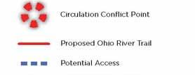
7 The Ohio River Trail Corridor Midland 6
8 The Ohio River Trail Corridor Coraopolis Aliquippa Monaca 7
9 Midland Borough Midland 8
10 Midland Borough Analysis Conclusions Active steel plants and support industries generate truck traffic that creates conflicts with PACyber School expansion and major main street infill redevelopment along Midland Avenue. Private developers interested in several block long infill redevelopments along western end of Midland Avenue requires support infrastructure, especially parking. Part of the proposed Ohio River Trail connection through the Borough travels along Railroad Avenue Stormwater management and pre treatment areas are needed. Planning Proposals and Priority Projects Create proposed Steel Way as a new green street to create truck route access from the east Route 68 to main gate of Allegheny Ludlum plant to remove the majority of truck traffic from Midland Avenue through the center of town. Rd Redevelop west end Ril Railroad davenue parcel from 3 rd to 4 th Avenue for public parking lot. Upgrade Railroad Avenue as a green alleyway to support Ohio River Trail and provide rain gardens at street end parks. 9
11 Midland West 10
12 Midland East Stromberg/Garrigan & Associates Brownfields Planning & Design Team


13 Midland 12
14 Midland East Proposed Steel Way green street Allegheny Ludlum Steel Main Gate
15 Midland Stromberg/Garrigan & Associates Brownfields Planning & Design Team
16 Midland Proposed parking lot to support infill redevelopment with stormwater management/rain gardens Stromberg/Garrigan & Associates Brownfields Planning & Design Team
17 Midland
18 Monaca Borough Monaca 17
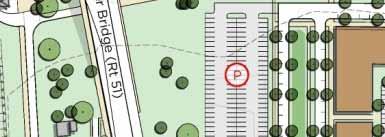
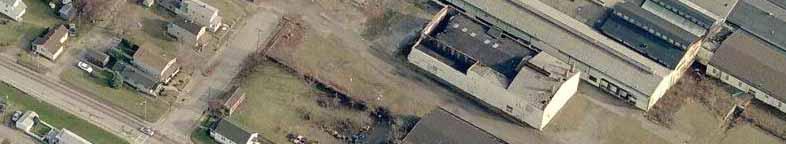
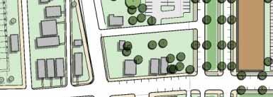
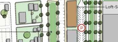
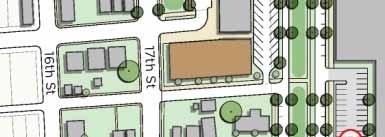
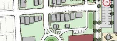
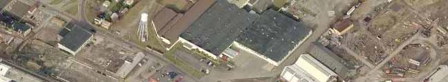
19 Monaca Borough Analysis Conclusions Former Colona Steel plant has a specialty metals fabricator but the bulk of the site is vacant and is located at key location on the river and is adjacent to residential neighborhoods. Property is owned by development company based in NJ. East Rochester Monaca Bridge access divides neighborhood context and the intersection of 17 th Avenue and Pennsylvania Avenue is confusing and hinders economic development. Part of the proposed Ohio River Trail connection through the Borough travels through Colona Steel site area. Potential for McClymonds transfer coal facility to close. Industrial area has poor vehicular access and circulation. Stormwater management and pre treatment areas are needed (CSO). Planning Proposals and Priority Projects Improve 17 th Street Gateway Corridor and intersection with roundabout and create proposed Monaca River Boulevard access to river. Promote first phase mixed use infill redevelop between 17 th Avenue and Monaca River Boulevard. Construction proposed Ohio River Trail from Monaca Field and along proposed Monaca River Boulevard. Partner with owner of Colona Steel site to promote mixed use redevelopment and site improvements to support existing industrial. 18
20 Monaca Borough Stromberg/Garrigan & Associates Brownfields Planning & Design Team 19

21 Monaca 20
22 Monaca Stromberg/Garrigan & Associates Brownfields Planning & Design Team 21


23 Monaca 22
24 Monaca 23
25 Monaca 24
26 Monaca Stromberg/Garrigan & Associates Brownfields Planning & Design Team 25
27 City of Aliquippa Aliquippa 26
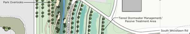
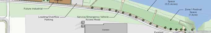
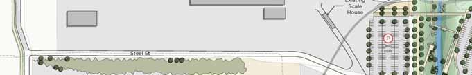
28 City of Aliquippa Analysis Conclusions Vehicular and pedestrian access to major industrial area and river hindered by deficient design of Franklin Avenue underpass. Community has strong desire to gain public access to river s edge and San Rocco festival looking for larger festival site. Industrial redevelopment is the main emphasis for the overall riverfront with the exception of the area adjacent to Logstown Run. Stormwater management and pre treatment areas are needed (CSO), Logstown Run outfall severally impaired. BCED currently constructing major Woodlawn Road connector. Planning Proposals and Priority i Projects Acquire Logstown Run outfall and perform major habitat restoration, stormwater management improvements and public park connection to extend Franklin Avenue to the river with trail connection. Improve vehicular circulation from existing Franklin Avenue underpass into Cronimet property and Steel Street connection to remove turning conflicts at underpass. Work with BCED to create public festivals ground, boat launch and vehicular access on their riverfront property not suitable for industrial redevelopment and improve access Create defined dfi dparking areas to serve industrial i uses during weekdays and public riverfront park parking during weekends and evening. 27
29 Monaca Stromberg/Garrigan & Associates Brownfields Planning & Design Team 28


30 Aliquippa 29
31 Monaca Stromberg/Garrigan & Associates Brownfields Planning & Design Team 30


32 Aliquippa 31
33 Aliquippa Stromberg/Garrigan & Associates Brownfields Planning & Design Team 32
34 Aliquippa Stromberg/Garrigan & Associates Brownfields Planning & Design Team 33
35 Aliquippa Stromberg/Garrigan & Associates Brownfields Planning & Design Team 34
36 Coraopolis Borough Coraopolis Stromberg/Garrigan & Associates Brownfields Planning & Design Team 35
37 Coraopolis Borough Riverfront and Station Areas Analysis Conclusions Riverfront is at a very desirable location along Ohio River back channel for redevelopment. And key property owner is actively exploring development options. Robert Morris University has expressed an interest in create a strong presence in the town and has major recreation facility on Neville Island across the back channel lfrom study area, including new rowing boathouse facility. RMU has a significant on campus housing shortage. Allegheny County proposing major recreation/soccer complex on adjacent riverfront site. Historic Station owned by Coraopolis Community Foundation and undertaking major capital campaign for restoration. Proposed Ohio River Trail runs adjacent or through both areas. Stormwater management and pre treatment areas are needed (major CSO issues). Planning Proposals and Priority Projects Riverfront Create 3 rd Avenue extension into riverfront site to support multi family residential, park, boathouse/launch and Ohio River Trail. Support RMU/landowner discussions i regarding boathouse project and potential ilstudent housing (both areas). Planning Proposals and Priority Projects Station Area Facilitate the create Neville Avenue Extension to serve station. Redevelop station as a regional transit and student shuttle multi modal hub. Assemble adjacent properties for mixed use infill (student housing) and create town square. 36
38 Coraopolis Riverfront Stromberg/Garrigan & Associates Brownfields Planning & Design Team 37
39 Coraopolis Riverfront Stromberg/Garrigan & Associates Brownfields Planning & Design Team 38
40 Monaca Stromberg/Garrigan & Associates Brownfields Planning & Design Team 39
41 Monaca Stromberg/Garrigan & Associates Brownfields Planning & Design Team 40
42 Coraopolis Station Area Stromberg/Garrigan & Associates Brownfields Planning & Design Team 41


43 Coraopolis Station Area Stromberg/Garrigan & Associates Brownfields Planning & Design Team 42
44 Coraopolis Station Area Stromberg/Garrigan & Associates Brownfields Planning & Design Team 43
From Partnership to Reality
 From Partnership to Reality New Partners for Smart Growth February 4, 2011 What is Sustainable (human) Development? It is development that meets the needs of the present without compromising the ability
Making Transit Oriented Development Work For Boonton, NJ
 Making Transit Oriented Development Work For Boonton, NJ Bloustein School of Planning and Public Policy Studio Dan Burton Loannie Dao Webster Slater Brandon Williams Ian Watson Maria Laham Nicola Mammes
Atlanta BeltLine, Inc. Pathways to Urban Sustainability
 Atlanta BeltLine, Inc. Pathways to Urban Sustainability September 30, 2010 WHAT IS THE ATLANTA BELTLINE? Transit 22-mile loop Parks 1300 + new acres Trails 33 miles Jobs & Economic Development 20 areas,
City of Meriden Harbor Brook Flood Control Project Overview
 City of Meriden Harbor Brook Flood Control Project Overview Updated August 2013 OVERVIEW The center of Meriden, including the HUB site is the low point of the town which is ringed by basalt ridges. Running
CHAPTER 8 ISSUES, CONCERNS, CONSTRAINTS AND OPPORTUNITIES
 CHAPTER 8 ISSUES, CONCERNS, CONSTRAINTS AND OPPORTUNITIES Introduction This River Conservation Plan was developed during a time of tremendous activity and effort in planning the transformation of the Delaware
12 th Street Connector Alignment Study VISIONING PUBLIC WORKSHOP - JUNE 25, :00PM TO 8:00PM
 12 th Street Connector Alignment Study VISIONING PUBLIC WORKSHOP - JUNE 25, 2018 6:00PM TO 8:00PM Goals for Today s Workshop Agenda: Project Introduction, Purpose, and Goals Existing Conditions Traffic
3.9 Systems Interrelationships
 191 Sustainability Building Blocks: The Comprehensive Plan Systems Community Form Economy Social Transportation Natural Resources Housing and Neighborhoods Utilities and Infrastructure Institutions.9 Systems
MEADOW RIVER RAIL TRAIL
 MEADOW RIVER RAIL TRAIL Nicholas, Fayette and Greenbrier Rail Line CSX Abandonment 2008 Greenbrier and Fayette County Partnership 2009 16.7 mile Purchased in July 2011. Trail Development Begins: Obama
Corridor Vision. 1Pursue Minnehaha-Hiawatha Community Works Project. Mission of Hennepin County Community Works Program
 1Pursue Minnehaha-Hiawatha Community Works Project Minnehaha-Hiawatha Community Works is a project within the Hennepin Community Works (HCW) program. The mission of the HCW program is to enhance how the
GREEN STREETS & INFRASTRUCTURE: A COUNTY APPROACH. Mimicking Nature to Manage Stormwater in Developed Areas
 GREEN STREETS & INFRASTRUCTURE: A COUNTY APPROACH Mimicking Nature to Manage Stormwater in Developed Areas Jennifer Gonzalez, Environmental Planner Passaic County Depar tment of Planning & Economic Development
E x E C U T I v E S U M M A R y / P L A N N I N G C O N T E x T 14 //
 14 // executive summary / planning context COMMUNITY GREENING PLAN PLANNING CONTEXT Capital Region Water has entered into a partial consent decree with the United States Department of Justice to address
A larger version of this map is located on the last page of this PDF.
 MAP Committee Input McLoughlin Area Draft Vision Map A larger version of this map is located on the last page of this PDF. 1. The map above is intended to portray a vision for the McLoughlin area. It highlights
Implementation Guide Comprehensive Plan City of Allen
 Implementation Guide 2030 Comprehensive Plan City of Allen DRAFT 2015 Implementation Guide Allen 2030 Comprehensive Plan INTRODUCTION The Comprehensive Plan serves as a guide for the growth and development
Camden SMART Initiative Stormwater Management and Resource Training
 Camden SMART Initiative Stormwater Management and Resource Training www.camdensmart.com Camden s Struggle with Stormwater 1 The City of Camden is served by a combined sewer system, which uses the same
Brownfields and Urban Agriculture
 Brownfields and Urban Agriculture The Convergence of Land Recycling and Food Policy Joseph Schilling, Director Metropolitan Institute Virginia Tech, Alexandria Campus (Jms33@vt.edu) www.mi.vt.edu Mission:
EXISTING PLANS Harriet Festing Center for Neighborhood Technology Midlothian Community Meeting March 12, 2015
 EXISTING PLANS Harriet Festing Center for Neighborhood Technology Midlothian Community Meeting March 12, 2015 BENEFITS Bring economic, community + environmental benefits Enhance property values Use
RIVER ARTS DISTRICT TRANSPORTATION PROJECT
 RIVER ARTS DISTRICT TRANSPORTATION PROJECT A section of the Public Meeting #3 December 6, 2012 The RiverWay Plan The Wilma Dykeman RiverWay is a 17 mile corridor along the French Broad and Swannanoa Rivers.
Cumberland Region Tomorrow is a private, non-profit, citizen based regional organization working with Greater Nashville Regional Council
 Cumberland Region Tomorrow is a private, non-profit, citizen based regional organization working with Greater Nashville Regional Council and others in the public and private sectors, dedicated to planning
DRAFT ROOSEVELT ROAD. District Recommendations. Figure 5.23 The Roosevelt Road Corridor
 CHAPTER 5 Figure 5.23 The Road Corridor Road will develop as a mixed-use corridor, emphasizing regional retail, west of the river and mixed-use development east of the river. KEY RECOMMENDATIONS 1. High
{Best Practices. Summary of Tools, Strategies and Best Practices from 11 Michigan Case Study Communities
 Case Studies Michigan Coastal Community Working Waterfronts { Summary of Tools, Strategies and from 11 Michigan Case Study Communities Table of Contents Zoning...2 Community and Stakeholder Collaboration
1.0 Circulation Element
 5/9/18 1.0 Circulation Element 1.1 Introduction As growth and development occur in Apache County, enhancements to its circulation system will be necessary. With time, more roads will be paved and air and
Promoting Economic Development Through Upfront SEPA Review: Lessons from South Downtown Tacoma
 Promoting Economic Development Through Upfront SEPA Review: Lessons from South Downtown Tacoma 1 This session will focus on the City of Tacoma s South Downtown Subarea Plan and associated Non-Project SEPA
Planning Commission March 14, Presented by: City of Bellingham Port of Bellingham
 Planning Commission March 14, 2013 Presented by: City of Bellingham Port of Bellingham 1 Agenda Waterfront District Background Waterfront District Proposal Overview Sub-area Plan Development Regulations
Route 1 Corridor Study
 Route 1 Corridor Study Westbrook, Connecticut A Vision for the Connecticut Shoreline Public Informational Meeting July 28, 2015 Lower Connecticut River Valley Council of Governments Fitzgerald & Halliday,
ARISE: The Rock Renaissance Area Redevelopment & Implementation Strategy
 2014 Professional Awards 1 ARISE: The Rock Renaissance Area Redevelopment & Implementation Strategy Janesville, WI Completed December 2014 Analysis & Planning Purpose of Project 2 The purpose of the Rock
Potential Green Infrastructure Strategies May 6, 2015 Workshop
 Potential Green Infrastructure Strategies May 6, 2015 Workshop Background The City of Cortland is developing the Tioughnioga Urban Headwaters Green Infrastructure Action Plan with funding from the National
Downtown River District
 City & Downtown Development Authority Partnership Infrastructure Analysis & Design Project Transportation & Utilities Fix Current Deficiencies Set the Stage for Future Infill & Redevelopment Who s Involved:
Street Flooding Mitigation Plan KYOVA Interstate Planning Commission. Presented to AMPO National Conference October 18, 2017
 Street Flooding Mitigation Plan KYOVA Interstate Planning Commission Presented to AMPO National Conference October 18, 2017 Saleem Salameh, Ph.D., P.E., M.ASCE Chet Parsons, AICP CTP Agenda: Background
Sustainable Storm Water Management
 Incorporating Water Management into the Community Planning Process August 16, 2012 Sustainable Storm Water Management Samantha Brown Environmental Engineer SD1 SD1 s Service Area CVG Airport SD1 Service
A BLUEPRINT FOR BROCKTON A CITY-WIDE COMPREHENSIVE PLAN
 A BLUEPRINT FOR BROCKTON A CITY-WIDE COMPREHENSIVE PLAN Public Meeting October 2016 1 Plan Summary and Discussion Public Meeting May 4 2017 City of Brockton Bill Carpenter, Mayor Department of Planning
October 25 Downtown Partnership and Action Plan Workshop Record of Group Table Results
 October 25 Downtown Partnership and Action Plan Workshop Record of Group Table Results During the October 25 workshop, participants were asked to rank their top priorities for the Downtown Action Plan.
Stakeholders Advisory Working Groups (SAWGs) Smart Growth and TOD Land Use (#11) SAWG Meeting
 Smart Growth and TOD Land Use (#11) SAWG Meeting") Presentation - Part II Tappan Zee Bridge/I-287 Corridor Project July 21, 2010 Slide 1. David Kooris (Regional Plan Association) welcomed members of the Land Use Stakeholders Advisory Working Groups (SAWGs)
Presentation - Part II Tappan Zee Bridge/I-287 Corridor Project July 21, 2010 Slide 1. David Kooris (Regional Plan Association) welcomed members of the Land Use Stakeholders Advisory Working Groups (SAWGs)
Workshop #3 June 13, 2016
 Downtown Ocoee Master Plan Workshop #3 June 13, 2016 Our Team Our Team and Tonight s Goal Quick Recap: Why a Downtown Plan? How are we developing the plan? How can you still be involved? What s left to
The transportation system in a community is an
 7 TRANSPORTATION The transportation system in a community is an important factor contributing to the quality of life of the residents. Without a sound transportation system to bring both goods and patrons
IMPLEMENTING SOMERSET COUNTY S INVESTMENT FRAMEWORK
 IMPLEMENTING SOMERSET COUNTY S INVESTMENT FRAMEWORK SMART CONSERVATION THROUGH SMART GROWTH NJ LAND CONSERVATION RALLY March 22, 2014 Laurette Kratina, PP, AICP, Supervising Planner Somerset County Planning
Animating the Rideau Canal December 2013
 Executive Summary Animating the Rideau Canal December 2013 Why study the Rideau Canal? The Rideau Canal has been an important part of Ottawa throughout its history, and has shaped and been shaped by the
SH 199 Corridor Master Plan. Community Meeting No. 2 May 31, 2017
 Community Meeting No. 2 May 31, 2017 Transportation Projects On or Near SH 199 SH 199 from 0.3 miles south of FM 1886 to south end of Lake Worth bridge Construct freeway mainlanes and frontage roads 10-Year
C. Westerly Creek Village & The Montview Corridor
 C. Westerly Creek Village & The VISION Community Vision When the goals of the city are achieved Westerly Creek Village, a distinctive community defined by Montview Boulevard and Westerly Creek, is a strong
TRANSPORTATION PROJECTS
 TRANSPORTATION PROJECTS 40 BUFFALO S LWRP PROPOSED PROJECTS T1. Niagara Street/Great Lakes Seaway Trail Streetscape Project City of Buffalo Department of Public Works Niagara Street from Niagara Square
CHAPTER 7: Transportation, Mobility and Circulation
 AGLE AREA COMMUNITY Plan CHAPTER 7 CHAPTER 7: Transportation, Mobility and Circulation Transportation, Mobility and Circulation The purpose of the Transportation, Mobility and Circulation Chapter is to
Northwest Rail Corridor and US 36 BRT Development Oriented Transit Analysis 4.4 STATION AREA FINDINGS
 4.4 STATION AREA FINDINGS Each station is different, and each one requires a separate set of recommendations based on the vision for the site. This section outlines an initial TOD strategy and recommendations
Overview of Southwestern Pennsylvania Commission s (SPC) 2040 Long Range Transportation Plan (LRTP)
 2040 Long Range Transportation Plan (LRTP)") Overview of Southwestern Pennsylvania Commission s (SPC) 2040 Long Range Transportation Plan (LRTP) Presented to Pennsylvania Agency Coordination Meeting May 27, 2015 Doug Smith & Ryan Gordon 1 Southwestern
Overview of Southwestern Pennsylvania Commission s (SPC) 2040 Long Range Transportation Plan (LRTP) Presented to Pennsylvania Agency Coordination Meeting May 27, 2015 Doug Smith & Ryan Gordon 1 Southwestern
LITTLETON RIVER DISTRICT REDEVELOPMENT PROJECT A LEGACY OF LEADERSHIP & COMMUNITY INVOLVEMENT
 LITTLETON RIVER DISTRICT REDEVELOPMENT PROJECT A LEGACY OF LEADERSHIP & COMMUNITY INVOLVEMENT Background Information Littleton Saranac Street Design Charrette Sponsored by the Town of Littleton and Plan
OFFICIAL CONTROLS IMPLEMENTATION LEGAL REQUIREMENTS
 IMPLEMENTATION The objective of the Implementation component of the Comprehensive Plan is to identify the changes that need to be made to the official controls in order to be consistent with the Comprehensive
Welcome. Comprehensive Plan & Transportation Plan Open House November 7, 2012
 Welcome Comprehensive Plan & Transportation Plan Open House November 7, 2012 Agenda Proposed future land use plan Comprehensive Plan strategies Traffic forecasts Future traffic operations Possible future
U T D N o r t h C a m p u s T O D and D o w n t o w n D e n t o n T O D
 U n i v e r s i t y o f T e x a s a t D a l l a s C i t y o f R i c h a r d s o n U T D N o r t h C a m p u s T O D and D o w n t o w n D e n t o n T O D Rick Leisner, AICP Assistant Director of Development
Southern Gateway Project and Public Green
 Southern Gateway Project and Public Green Transportation and Trinity River Project Committee May 23, 2016 Purpose of Presentation Provide the history and an overview of the Southern Gateway Project (SGP)
VACANT TO VIBRANT : GREEN INFRASTRUCTURE & URBAN REVITALIZATION
 VACANT TO VIBRANT : GREEN INFRASTRUCTURE & URBAN REVITALIZATION Calumet Summit 2013: Connecting for Action Lauren Riga, Director City of Gary Department of Green Urbanism Gary Storm Water Management District
Western Pennsylvania Conservancy Clairton & Harrison Community Greening Assessment Projects Request for Proposals July 2018
 Western Pennsylvania Conservancy Clairton & Harrison Community Greening Assessment Projects Request for Proposals July 2018 Proposal Information The Western Pennsylvania Conservancy (WPC) is seeking proposals
Chapter 5: Natural Resources and Environment
 NATURAL RESOURCES AND ENVIRONMENT 5-1 5 Chapter 5: Natural Resources and Environment BACKGROUND AND INTENT Urban expansion represents the greatest risk for the future degradation of existing natural areas,
Kenilworth Avenue and Town of Cheverly Industrial Study Briefing
 Kenilworth Avenue and Town of Cheverly Industrial Study Briefing The Maryland-National Capital Park and Planning Commission Prince George s County Planning Department www.pgplanning.org Vanasse Hangen
DRAFT City of Titusville 2040 Comprehensive Plan Future Land Use, Housing, and Transportation Elements April 16, 2018
 DRAFT City of Titusville 2040 Comprehensive Plan Future Land Use, Housing, and Transportation Elements April 16, 2018 Prepared by Canin Associates for the City of Titusville About the Comprehensive Plan:
National Association of Recreation Resource Planners Conference
 DEVELOP INTERPRET RESTORE National Association of Recreation Resource Planners Conference Pittsburgh-to-Harrisburg Main Line Canal Greenway new connections between old neighbors Learning Objectives By
Former Rockcliffe Airbase Community Design Plan Guiding Design Vision and Principles December 4, 2013
 APPENDIX 5 - Guiding Design Vision and Principles Former Rockcliffe Airbase Community Design Plan Guiding Design Vision and Principles December 4, 2013 Vision Statement The redevelopment of the former
Plan-It Greenville (2009) Comprehensive Plan 5-Year Update
 Comprehensive Plan 5-Year Update") Plan-It Greenville (2009) Comprehensive Plan 5-Year Update What is the comprehensive plan: Collecting communitywide data Projecting future population growth Setting communitywide goals Framing policies
Plan-It Greenville (2009) Comprehensive Plan 5-Year Update What is the comprehensive plan: Collecting communitywide data Projecting future population growth Setting communitywide goals Framing policies
Overview and Update of the Rutgers-New Brunswick Physical Master Plan. January 2015
 Overview and Update of the Rutgers-New Brunswick Physical Master Plan January 2015 Failure To Plan, is Planning For Failure Winston Churchill 2 Good Planning; The Key to Success 3 The university physical
Por favor, levanten la mano si necesita traduccion en espanol Please raise your hand if you need Spanish translation
 FEDERAL BOULEVARD CORRIDOR WIDE STUDY PUBLIC MEETING #1 APRIL 27, 2016 Por favor, levanten la mano si necesita traduccion en espanol Please raise your hand if you need Spanish translation HDR DESIGN WORKSHOP
LEED-ND 101: Practical Strategies for Achieving Sustainability Goals. Travis Parker Lakewood Planning Director
 LEED-ND 101: Practical Strategies for Achieving Sustainability Goals Travis Parker Lakewood Planning Director Metro Vision Idea Exchange Oct 11, 2012 West Corridor Stations West Corridor Overview West
Southeast Michigan Council of Governments
 Southeast Michigan Council of Governments SEMCOG Green Infrastructure Activities Regional Green Infrastructure Vision GLRI Green Streets EPA Technical Assistance MDOT Grants Green Infrastructure Vision
Study Area. Capitol Way. Greening America s Capitals 11/13/2014. A Greening America s Capitals Project
 Olympia, WA: Greening Capitol Way Supporting Communities move towards sustainability is a priority for the federal government. A Greening America s Capitals Project Office of Sustainable Communities U.S.
Executive Summary. NY 7 / NY 2 Corridor
 Executive Summary NY 7 / NY 2 Corridor Transportation and Land Use Study December 2005 Prepared for: Town of Colonie Capital District Transportation Committee Prepared by: Introduction: Land use decisions
Corridors. Re-vitalize our Corridors and Gateways
 Corridors Re-vitalize our Corridors and Gateways Artist s rendering from the 287 Strategic Plan, 2015 Corridors are the major throughways of Loveland but they also provide important commercial, community
Preliminary Subdivision Plan
 Preliminary Subdivision Plan 704-525-8000 Suite 1200 Executive Summary the east huntersville area development plan provides a series of development initiatives and public improvements for land east of
Roosevelt Corridor. R e i n v e s t m e n t P l a n. Public Meeting Gilbert Elementary School May 12, :00 pm
 Roosevelt Corridor R e i n v e s t m e n t P l a n Public Meeting Gilbert Elementary School May 12, 2009 6:00 pm Agenda 6:00 6:10 6:25 6:40 6:55 7:00 Opening Comments Councilwoman Jennifer V. Ramos District
The Five Components of the McLoughlin Area Plan
 The Five Components of the McLoughlin Area Plan This documents contains the complete language of the five components of the McLoughlin Area Plan: The Vision Statement The Values The Guiding Principles
the South Lincoln Redevelopment, Denver, CO
 the South Lincoln Redevelopment, Denver, CO Chris Parr Director of Development, Denver Housing Authority cparr@denverhousing.org Renee Martinez Stone Urban Planner/Owner, Perspective -3 renee@perspective-3.com
Atlanta BeltLine Subarea 3 Master Plan Update
 Atlanta BeltLine Subarea 3 Master Plan Update April 14, 2018 Workshop Meeting 1 22 miles, connecting 45 neighborhoods 22 MILES of transit 46 MILES of streetscapes and complete streets 33 MILES of urban
WALTER RAND TRANSPORTATION CENTER
 WALTER RAND TRANSPORTATION CENTER PLANNING AND DESIGN STUDY Public Meeting May 25, 2017 TONIGHT S AGENDA Introduction and Welcome Project Objectives The Study Area: WRTC and its Context Circulation Assessment
Elliot Park 2. Neighborhood Master Plan. Historical Perspective
 Elliot Park 2 Neighborhood Master Plan Historical Perspective August 2002 Early History Development patterns and the growth of Minneapolis largely grew out of the city s historical response to its geography.
Transportation Land Use Integration & Regional Planning. Don Kostelec, AICP Senior Planner, Louis Berger Group February 1, 2010
 Transportation Land Use Integration & Regional Planning Don Kostelec, AICP Senior Planner, Louis Berger Group February 1, 2010 Transportation Land Use Integration DOT-HUD-EPA Sustainable Communities Initiative
38 Queen s University Campus Master Plan Part 1
 38 Queen s University Campus Master Plan Part 1 46 The Campus at the City Scale Chapter 4 The Campus at the City Scale 39 Queen s is an urban University centrally located in Kingston. Decisions made by
3. VISION AND GOALS. Vision Statement. Goals, Objectives and Policies
 Vision Statement Queen Creek s interconnected network of parks, trails, open spaces and recreation opportunities provide safe and diverse activities and programs that sustain its unique, small town, equestrian
Delaware River Waterfront Corporation
 Delaware River Waterfront Corporation Delaware River Waterfront Corporation Created in January 2009 to replace Penn s Landing Corporation o Open, accountable, effective leadership o New Board of Directors
City of Iowa City Department of Neighborhood and Development Services Department of Parks and Recreation Department of Public Works City Manager s
 RFP Pre-submittal meeting December 18, 2015 City of Iowa City Department of Neighborhood and Development Services Department of Parks and Recreation Department of Public Works City Manager s Office Background
The Rocky Mountain Arsenal and the Northeast Greenway Corridor Project:
 The Rocky Mountain Arsenal and the Northeast Greenway Corridor Project: Contamination to Collaboration Presented by Howard Kenison Overview of Presentation Rocky Mountain Arsenal Contamination Litigation,
Asheville Design Center March 2010
 Community-Based Design Update Asheville Design Center March 2010 www.ashevilledesigncenter.org 1 introduction contents 1. Introduction 2. Background 3. ovember Design Charrette 4. January Work Session
Stakeholder Workshop #2
 Welcome! W3 th Realignment Study Stakeholder Workshop #2 We are pleased you are here to help advance the study, and we are eager to hear your ideas. How to get the most out of this workshop: Listen to
The West Vaughan Employment Area Secondary Plan Policies
 Part 2: The West Vaughan Employment Area Secondary Plan Policies 2.1 General Policies It is the policy of Council: 2.1.1. That the West Vaughan Employment Area (the WVEA), identified on Schedule 1, will
Billing Code: DEPARTMENT OF HOUSING AND URBAN DEVELOPMENT [Docket No. FR-6072-N-01]
![Billing Code: DEPARTMENT OF HOUSING AND URBAN DEVELOPMENT [Docket No. FR-6072-N-01]](/thumbs/91/107309814.jpg "Billing Code: DEPARTMENT OF HOUSING AND URBAN DEVELOPMENT [Docket No. FR-6072-N-01]") This document is scheduled to be published in the Federal Register on 12/18/2017 and available online at https://federalregister.gov/d/2017-27194, and on FDsys.gov Billing Code: 4210-67 DEPARTMENT OF HOUSING
This document is scheduled to be published in the Federal Register on 12/18/2017 and available online at https://federalregister.gov/d/2017-27194, and on FDsys.gov Billing Code: 4210-67 DEPARTMENT OF HOUSING
PSRC REVIEW REPORT & CERTIFICATION RECOMMENDATION
 PSRC REVIEW REPORT & CERTIFICATION RECOMMENDATION KITSAP COUNTY COUNTYWIDE PLANNING POLICIES July 2, 2012 BACKGROUND A major emphasis of the Washington State Growth Management Act (GMA) is the need to
Planning for TOD Implementation at a Corridor Scale
 Planning for TOD Implementation at a Corridor Scale Catherine Cox Blair, Reconnecting America Presentation to DRCOG and the Sustainable Communities Initiative May 14, 2012 What is Reconnecting America?
FUNDING CORRIDOR REVITALIZATION
 FUNDING CORRIDOR REVITALIZATION Integrated corridor planning for the 21 st Century America Planning Association Annual Conference Atlanta, GA April 27, 2014 Mariia Zimmerman, MZ Strategies, LLC mariia@mzstrategies.com
NASSAU COUNTY TOWN HALL NEW YORK & CONNECTICUT SUSTAINABLE COMMUNITIES. A Unique Bi-State Partnership to Improve Jobs, Housing and Transportation
 NASSAU COUNTY TOWN HALL NEW YORK & CONNECTICUT SUSTAINABLE COMMUNITIES A Unique Bi-State Partnership to Improve Jobs, Housing and Transportation Police Headquarters Auditorium Mineola, NY December 9 th,
Scope of Services. River Oaks Boulevard (SH 183) Corridor Master Plan
 Corridor Master Plan") Scope of Services River Oaks Boulevard (SH 183) Corridor Master Plan PROJECT AREA The project area consists of the River Oaks Boulevard (SH 183) corridor bounded by SH 199 at the northern end and the Trinity
Scope of Services River Oaks Boulevard (SH 183) Corridor Master Plan PROJECT AREA The project area consists of the River Oaks Boulevard (SH 183) corridor bounded by SH 199 at the northern end and the Trinity
CITIZEN S ADVISORY COMMITTEE PUBLIC REALM CONCEPT PRESENTATION. October 25, 2018
 CITIZEN S ADVISORY COMMITTEE PUBLIC REALM CONCEPT PRESENTATION October 25, 2018 AGENDA Placemaking Study Overview Public Space Design Character and Concepts / Updated Visuals PLACEMAKING STUDY OVERVIEW
Delaware River Port Authority Southern New Jersey Waterfront Master Plan
 Delaware River Port Authority Southern New Jersey Waterfront Master Plan Press Conference January 11, 2006 Agenda Plan Purpose & Objectives Market Demand Residential Forecast Maritime Forecast Waterfront
CONTEXT: the Highway, the River + the Railroads run through us.
 CONTEXT: the Highway, the River + the Railroads run through us. I-25 36 In the past they have divided us, now we have an opportunity to unite us. I-76 I-270 I-76 CSU I-25 LEGEND Cut + Cover River North
Whitemarsh Comprehensive Plan Update: Housing & Land Use. Public Workshop #3: September 20, 2018
 Whitemarsh Comprehensive Plan Update: Housing & Land Use Public Workshop #3: September 20, 2018 Agenda Welcome Process Recap What We ve Heard The Plan Framework Review of Recommended Actions Land Use Housing
City of Long Beach. creating vibrant and exciting places
 City of Long Beach creating vibrant and exciting places Land Use Element Urban Design Element Overview of the two draft General Plan elements Discuss areas of change Economic goals of the plans Case study
WEST OAKLAND SPECIFIC PLAN Final Plan. 2. Vision & Goals. 2.1 Community-Based Goals and Objectives
 WEST OAKLAND SPECIFIC PLAN Final Plan 2. Vision & Goals 2.1 Community-Based Goals and Objectives June 2014 2: Vision & Goals The vision of the West Oakland Specific Plan is to see this remarkable community
Committee Meeting: Downtown Today & Concept Refinement September 11, 2017
 Committee Meeting: Downtown Today & Concept Refinement September 11, 2017 AGENDA 1. Brief Input Update 2. Comprehensive Plan Principles 3. Downtown Today 4. Concept Updates 5. Future Schedule What is a
Table L-1 Summary Action Strategy. Action Item Timing Status Responsible Agency
 CHAPTER 4: CIRCULATION ELEMENT ISSUE #1: MAJOR THOROUFARES AND TRANSPORTATION ROUTES A balanced transportation system for Fontana is provided that meets the mobility needs of current and future residents
Arlington, Virginia is a worldclass
 EXECUTIVE S U M M A RY Arlington maintains a rich variety of stable neighborhoods, quality schools and enlightened land use policies, and received the Environmental Protection Agency s highest award for
Mississippi Skyway Preliminary Engineering Report
 EXECUTIVE SUMMARY Mississippi Skyway Preliminary Engineering Report CITY OF RAMSEY, MINNESOTA DECEMBER 2014 City of RAMSEY EXECUTIVE SUMMARY Project Need and Intent The Mississippi Skyway pedestrian bridge
Bristol Marsh Heritage Conservancy
 Bristol Marsh Heritage Conservancy The Pennsylvania Environmental Council (PEC) protects and restores the natural and built environments through innovation, collaboration, education and advocacy. PEC believes
TREASURE COAST REGIONAL PLANNING COUNCIL M E M O R A N D U M. To: Council Members AGENDA ITEM 5H
 TREASURE COAST REGIONAL PLANNING COUNCIL M E M O R A N D U M To: Council Members AGENDA ITEM 5H From: Date: Subject: Staff October 17, 2008 Council Meeting Local Government Comprehensive Plan Review Draft
Bruce Adams, Waste Water Treatment Plant Operations Manager, City of Cortland Chris Bistochi, Public Works Director, City of Cortland
 MEMORANDUM (DRAFT) Date: January 14, 2014 To: Mack Cook, Director of Administration and Finance, City of Cortland Chris Bistochi, Director of Public Works Department, City of Cortland Amanda Barber, Cortland
495/MetroWest Development Compact Plan Citizen Planner Training Collaborative Conference. March 17, 2012
 495/MetroWest Development Compact Plan Citizen Planner Training Collaborative Conference March 17, 2012 Project Process Local and Regional Priority Areas Growth Scenarios Transportation Investment Categories
This page has been intentionally left blank.
 This page has been intentionally left blank. Chapter 3 3-2 3. Employment 3.A Niagara Economic Gateway 3.A.1 General The Niagara Economic Gateway comprises: a) The Gateway Economic Zone which includes all
The Benefits and Challenges Associated with Green Infrastructure Practices
 The Benefits and Challenges Associated with Green Infrastructure Practices Thomas M. Evans ASLA, LEED AP Regional Green Infrastructure Design Services Director OWEA Technical Conference, June 20, 2013