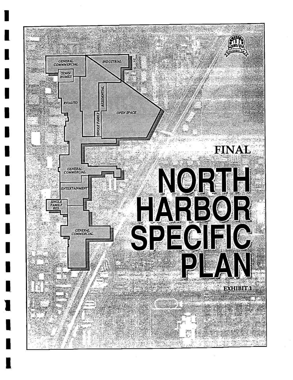
NORTH HARBOR SPECIFIC PLAN
|
|
|
- Egbert Hunter
- 6 years ago
- Views:
Transcription
1
; ZOA 2007-2 (August 6, 2007, NS-2756); ZOA 2008-2 (October 6, 2008,")
2 NORTH HARBOR SPECIFIC PLAN City of Santa Ana Submitted By: Planning and Building Agency GPA 92-7/AA 10-61/SP2 The following is a chronology of the approved zoning ordinance amendments that have been incorporated into this document since it was adopted by Santa Ana City Council on May 16, 1994: ZOA (May 15, 2000, NS-2428); ZOA (August 6, 2007, NS-2756); ZOA (October 6, 2008, NS-2773); and ZOA (June 1, 2009, NS-2784).
3
4
5
6
7
8
9
10
11
12
13
14
15 NEWHOPE ST. NEWHOPE ST. MOUNTAIN VIEW ST. MOUNTAIN VIEW ST. MOUNTAIN VIEW ST. GATES ST. GATES ST SHANNON ST. ELAINE DR. FIGUEROA WEST ST. SHANNON ST. SPAR ST. ST. ELAINE DR. BEWLEY ST. BEWLEY ST. ST. GUNTHER ST. GUNTHER ST. BEWLEY ST. JACKSON JACKSON ST. LAUREL ST. SUSAN ST. CLINTON ST. BUENA ST. CLINTON ST. NORTH HARBOR SPECIFIC PLAN WESTMINSTER AV. SEVENTEENTH ST. CENTURY BL. GENERAL COMMERCIAL BOYER AV. INDUSTRIAL SUNSWEPT AV. MORNINGSIDE AV. SUNSWEPT TOWN HOMES SUNSWEPT AVE. MORNINGSIDE AV. MORNINGSIDE AV. PENNY AV. WASHINGTON AV. MAURIE AV. OAKFIELD AV. MOUNTAIN VIEW ST. HASTINGS ST. FAY CIR. R1 R1 GATES ST. MARY CIR. CELESTE GEORGINE ST. ST. RV/AUTO 11TH ST. RESIDENTIAL CELESTE ST. O. C. F. C. D MOONRIDGE AV. ROOSEVELT AV. HAZARD AV. FAY CIR. SINGLE FAM. RES. SINGLE FAM. RES. INDUSTRIAL OPEN SPACE SILVER DR. 5TH ST. 7TH ST. WILLOWICK DR. 5TH ST. GENERAL COMMERCIAL FIRST ST. CLE DEL NORTE BERRY ST. ACAPULCO AV. MOUNTAINVIEW ST. CAMILLE ST. TAMPION AV. O.C.F.C.D MOUNTAINVIEW ST. TOLAND ST. GATES ST. HIGHLAND AV. WISTERIA PL. FLIGHT AV. ROBERTS DR. KENT AV. ELLIOTT PL. O.C.F.C.D MCFADDEN AV. SHANNON ST. SINGLE FAMILY RES. FLIGHT AV. WISTERIA PL. ROBERTS DR. SPAR ST. ENTERTAINMENT DENNIS ST. DENNIS ST. BEWLEY ST. GUNTHER ST. CLE SOLEDAD GENERAL COMMERCIAL GUNTHER ST. ROBERTS DR. CLE DEL SUR PINE ST. JACKSON ST. CAMILLE ST. FLIGHT AV. LAUREL ST. SHAW PL. CHESTNUT AV. CHARLAINE AV. LAUREL CT. JAMES AV. CORWIN CT. SISSON AV. SUSAN ST. LAUREL ST. SUSAN ST. SANTA ANA RIVER ARAPAHO DR. ARAPAHO DR. RAYMAR ST. WISTERIA PL. SHAWNEE DR. CUBBON ST. SHAWNEE DR. MARK ST. YUMA CIR. MOHAWK DR. CUBBON ST. PLUTE DR. MOHAWK DR. CAMILE ST. WILLITS ST. NAKOMA DR. WISTERIA RAYMAR ST. PL. MARK ST. AZTEC CIR. HIGHLAND ST. BROOK ST. REGENT DR. ELLIOTT PL. CRYSTAL LN. SPAR ST. LEHNHARDT AV. Santa Ana City Limits KENT AV. HARBOR BL. FIGUEROA ST. KENT AV. CRYSTAL LN. LEHNHARDT AV. JACKSON ST. LINGAN LN. ADRIN WY. EDINGER AV. GATES ST. REGENT DR. RICHARDSON ST. LILAC AV. MT MITCHELL CIR. MT MATTERHORN ST. MT JACKSON ST. ARAPAHO DR. LA VERNE AV. SHAWNEE DR. DAHL LN. MOHAWK DR. NAKOMA DR. Figure 3.1 North Harbor Specific Plan Emphasis Zones 12
16
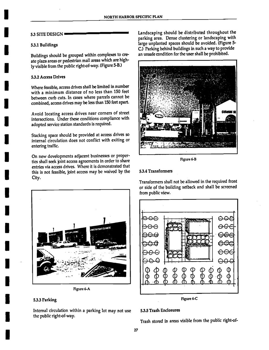
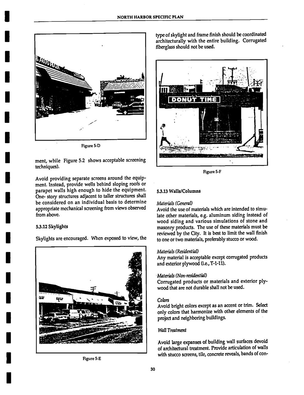
17 NORTH HARBOR SPECIFIC PLAN Florist shops Furniture stores Grocery stores Home improvement stores Jewelry stores Office, business machine and computer stores Pet shops and supplies Specialty retail stores Sporting goods stores Variety stores Other uses of a similar operation or nature 2. Offices, including: Administrative services Business services Design, architectural or planning services Financial institutions Medical and dental offices Professional services Veterinary offices Other uses of a similar operation or nature 3. Cinema (indoor) excluding "adult-only" 4. Public facilities and offices Conditionally Permitted Uses The following uses may be permitted subject to the issuance of a conditional use permit pursuant to the Santa Ana Municipal Code: 1. Drive-through facilities whether part of another permitted use, a conditionally permitted use, or as a separate facility 2. Parking structures 3. Service and /or gasoline stations 4. Restaurants and other eating establishment, including take-out, but not including drivethrough facilities 5. Public dance halls and public dance places with or without a cover charge 6. Transient/residential hotels as defined in Section of the Santa Ana Municipal Code Minimum Lot Size and Dimensions The minimum size of any development proposal shall be 15,000 gross square feet. The minimum lot frontage shall be 120 feet on a public right-of-way. Separately-owned units of real property may be deemed a single lot for the purposes of this section if they are subject to conditions, covenants and restrictions, and reciprocal easements of access that provide for unified responsibility for vehicle access, parking, landscaping and signage. Adjacent parcels under the same ownership shall be combined and developed under one site plan or other development permit Special Requirements 1. The following items shall be screened from view from any arterial or collector street: Loading docks, service bays, garage doors, and loading areas Utility meters Mechanical equipment Trash storage 2. The design of all development within the General Commercial District shall be such that significant building architectural and landscape elements are present on all building elevations DESIGN STANDARDS Refer to Chapters 5 and 6 for Design and Development Standards. 3.6 ENTERTAINMENT The Entertainment District is intended to provide an area along Harbor Boulevard specifically set aside for private, profit-making recreation and family entertainment activities such as restaurants, skating rinks, theaters, or night clubs. Development in this district should be well integrated with Santa Anita Park with shared access where possible and integrated pedestrian circulation. This land use designation is concentrated in the mid block area between First Street and McFadden Avenue and forms the central focus for the General Commercial zone. Typical land uses within this zone include restaurants, theaters, movie theaters, health leisure clubs, night clubs, community centers, urban open space including outdoor display and entertainment areas, and other leisure activities Uses Permitted Health clubs 2. Ice skating and roller skating rinks 3. Miniature golf courses and driving ranges 4. Batting cages 5. Cinema (indoor) excluding ''adult-only" 6. Museums and other publicly or not-forprofit operated cultural or similar institutions 7. Live theater
18 NORTH HARBOR SPECIFIC PLAN 8. Bowling 9. Other uses of a similar operation or nature as deemed appropriate by the Planning Manager. 10. Churches and accessory church buildings subject to the issuance of a conditional use permit pursuant to Article V, Chapter 41 of the Santa Ana Municipal Code Conditionally Permitted Uses The following uses may be permitted subject to the issuance of a conditional use permit pursuant to the Santa Ana Municipal Code: 1. Restaurant and other eating establishments 2. Other uses of a similar operation or nature as deemed appropriate by the Planning Manager Minimum Lot Size and Dimensions The minimum lot size in this district is 15,000 square feet. The minimum lot frontage shall be 120 feet. The whole of each ownership shall be developed as an integrally planned unit with access and parking being shared with adjacent uses to the maximum extent feasible, a uniform architectural style, a common landscape plan, and under a single site plan or other development permit Special Requirements 1. The following items shall be screened from view from any arterial or collector street and shall be consistent with all other applicable provisions of the Santa Ana Municipal Code: Loading docks, service bays, garage doors and loading areas Utility meters (shall be within a building footprint) Mechanical equipment (shall be within a building footprint) Trash storage 2. The design of all development within the Entertainment district shall be such that significant building architectural and landscape elements are present on all sides fronting on a public right-of-way Special Requirements Special requirements shall be the same as those contained in Sections through of the Santa Ana Municipal Code Design Standards Refer to Chapters 5 & 6 for design and development standards 3.7 INDUSTRIAL The Industrial District is intended for application in the existing Industrial District along Westminster Avenue immediately east of the Pacific Electric right-of-way. The purpose of this district is to maintain the present mix of industrial as they now are, but to allow a general upgrading of the area Uses Permitted Permitted uses in the Industrial District shall be the same as those in Section of the Santa Ana Municipal Code Conditionally Permitted Uses Conditionally permitted uses in the Industrial District shall be the same as those in Section of the Santa Ana Municipal Code (with the exception that any C-2 use permitted in this district shall be within 100 feet of Westminster Avenue) Minimum Lot Size Dimension The minimum lot size shall be one (1) acre, and the ratio of floor area to lot size shall not exceed 0.40 to 1. The minimum lot frontage shall be 100 feet Special Requirements Special requirements shall be the same as those contained in Section through of the Santa Ana Municipal Code Design Standards Refer to Chapters 5 and 6 for Design and Development Standards. 15
19
20
21
22
23
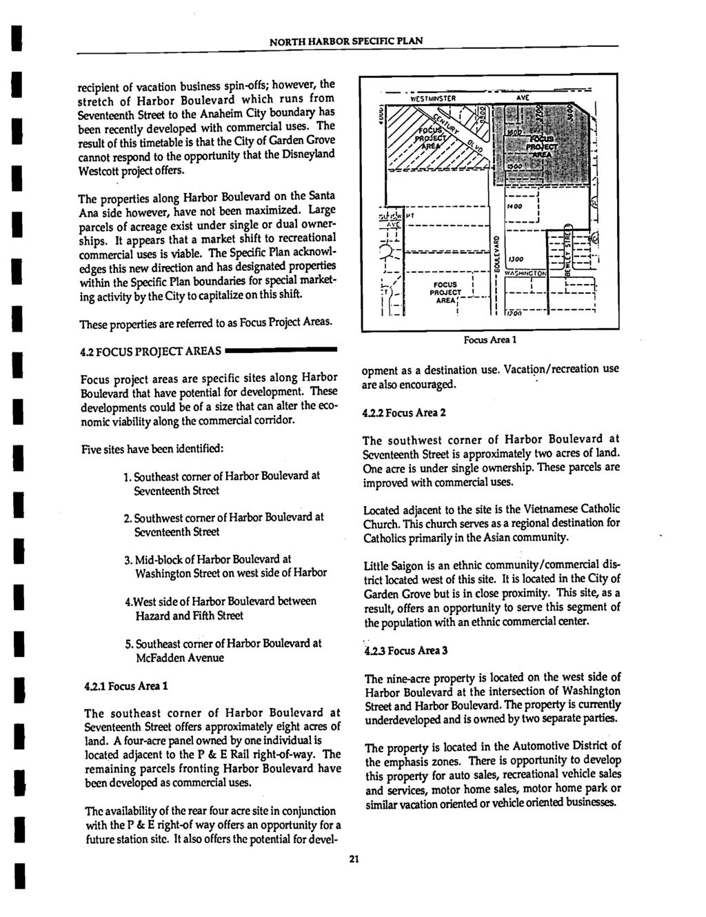
24
25
26
27
28
29
30
31
32
33
34
35
36
37
38
39
40
41
42
43
44
45
46
47
48
49
50
51
52
53
54
55
56
57
58
59
60
61
62
63
64
65
66
67
68
69
70
71
72
73
74
75
76
77
78
79
80
81
82
83
CHAPTER 11 HC HIGHWAY COMMERCIAL DISTRICT
 CHAPTER 11 HC HIGHWAY COMMERCIAL DISTRICT SECTION 11.01 DESCRIPTION AND PURPOSE This District is intended primarily for uses emphasizing highway related service, such as service stations, restaurants,
CHAPTER 21 NC-PUD NEIGHBORHOOD COMMERCIAL PUD DISTRICT
 CHAPTER 21 NC-PUD NEIGHBORHOOD COMMERCIAL PUD DISTRICT Section 21.1. Title and Purpose. The Neighborhood Commercial Planned Unit Development District, designated the, is intended for commercial uses of
2.11 GC - General Commercial
 2.11 GC - General Commercial Intent - GC: s are established to provide a location for higher volume and higher intensity commercial uses than the NR District. Activities in this District are often large
CHAPTER 10 GC GENERAL COMMERCIAL DISTRICT
 CHAPTER 10 GC GENERAL COMMERCIAL DISTRICT SECTION 10.01 DESCRIPTION AND PURPOSE A. This District is intended for commercial development of a general nature near areas where greater concentrations of residential
Purpose of Zoning Regulations. B-L Zoning Amendment. B-L Zone Permitted Uses. B-L Zone Definitions. History of B-L Zone. Map of B-L Zones in City
 Purpose of Zoning Regulations B-L Zoning Amendment May 20, 2003 City of Cumberland http://www.adventuregovernment.com Zoning districts are established to provide appropriate locations for different types
SECTION 21. MU-VS MIXED USE VIRGINIA SQUARE DISTRICTS
 SECTION 21. MU-VS MIXED USE VIRGINIA SQUARE DISTRICTS The purpose of the MU-VS Mixed Use Virginia Square classification is to encourage coordinated mixed-use development of medium-density residential and
3.0 LAND USE PLAN. 3.1 Regional Location. 3.2 Existing Conditions Existing Uses. Exhibit Regional Location Map
 3.0 LAND USE PLAN 3.1 Regional Location The Anaheim Resort Specific Plan (ARSP) area is located in the City of Anaheim, which is 35 miles southeast of downtown Los Angeles and 7 miles northwest of Santa
DRAFT FOR COMMENT: EASTLAKE AVENUE PEDESTRIAN DISTRICT OVERLAY ORDINANCE
 DRAFT FOR COMMENT: EASTLAKE AVENUE PEDESTRIAN DISTRICT OVERLAY ORDINANCE Background: One of many actions in the 1998 Eastlake Neighborhood Plan was a proposal for an Eastlake Avenue Pedestrian District
ARLINGTON COUNTY, VIRGINIA
 ARLINGTON COUNTY, VIRGINIA County Board Agenda Item Meeting of September 19, 2015 DATE: September 11, 2015 SUBJECTS: Outdoor Café at Citizen Burger Bar A. SP# 418 Site Plan Amendment to modify an approved
CHAPTER 20: INSTITUTIONAL USE DEVELOPMENT STANDARDS
 CHAPTER 20: INSTITUTIONAL USE DEVELOPMENT STANDARDS ARTICLE 1: GENERAL INSTITUTIONAL USE STANDARDS 320-01. Application The provisions of this Chapter shall apply to the following uses in any zone: (e)
ARTICLE XVIII C 1 CENTRAL BUSINESS DISTRICT
 ARTICLE XVIII C 1 CENTRAL BUSINESS DISTRICT SECTION 1. INTENT AND PURPOSE OF DISTRICT: The C 1 Central Business District is intended for the purpose of grouping retail merchandising activities into a concentrated
Chapter PEDESTRIAN COMMERCIAL (PC) ZONING DISTRICT
 ZONING DISTRICT") Chapter 11-17 PEDESTRIAN COMMERCIAL (PC) ZONING DISTRICT Sections: 11-17-01 GENERAL PURPOSE 11-17-02 PERMITTED BUILDING TYPES 11-17-03 USES PERMITTED WITH DESIGN REVIEW 11-17-04 USES PERMITTED BY CONDITIONAL
Chapter 11-17 PEDESTRIAN COMMERCIAL (PC) ZONING DISTRICT Sections: 11-17-01 GENERAL PURPOSE 11-17-02 PERMITTED BUILDING TYPES 11-17-03 USES PERMITTED WITH DESIGN REVIEW 11-17-04 USES PERMITTED BY CONDITIONAL
CHAPTER 3 LAND USE, ZONING, AND DEVELOPMENT STANDARDS
 SEPTEMBER 3, 2013 CORDES RANCH SPECIFIC PLAN: TRACY, CALIFORNIA CHAPTER 3 LAND USE, ZONING, AND DEVELOPMENT STANDARDS 3.1 INTRODUCTION The Specific Plan Area is divided into four zoning districts: General
MIXED-USE VILLAGE OVERLAY FLOATING DISTRICT
 MIXED-USE VILLAGE OVERLAY FLOATING DISTRICT Zoning regulations developed by committee to the Planning Board for the Town of DeWitt, NY Issue date: 13 July 2017 revised 3/12/2018, revised 4/26/2018, 5/9/2018
Chapter 7: Land Use Plan
 Chapter 7: Land Use Plan The intended purpose of the Land Use Plan is to guide the future physical development of Wall Township by designating proposed land use categories including proper location and
FUTURE LAND USE ELEMENT
 FUTURE LAND USE ELEMENT GOAL I: To create and sustain a great place to live, play, and prosper Objective 1: The City of Ocala shall incorporate the principles and strategies of the Ocala 2035 Vision into
2.18 MU Mixed Use District.
 2.18. Intent - The is established to promote the development of an urban residential environment. The regulations are intended to encourage single family urban residential use and development while allowing
AN ORDINANCE THE COUNCIL OF THE CITY OF PHILADELPHIA HEREBY ORDAINS:
 AN ORDINANCE Amending Title 14 of The Philadelphia Code, entitled Zoning and Planning, by amending Section 14-507, entitled /CDO, Central Delaware Riverfront Overlay District, under certain terms and conditions.
Planning Projects: Highlights
 Planning Projects: Highlights In Process, Under Review, and Under Construction. Transportation Advisory Commission October 23, 2014 Overview of Planning Process PPR Entitlement Design Review Building Permit
OVERVIEW OF LAND USE AND ZONING
 Current Land Use CHAPTER 5 OVERVIEW OF LAND USE AND ZONING The land use in the Study Area is substantially comprised of varying types of commercial uses. Assorted types of retail uses are predominant,
PLANNING COMMISSION AGENDA REPORT. Members of the Planning Commission. Andrew Cohen-Cutler, Associate Planner
 PLANNING COMMISSION AGENDA REPORT ITEM 7 ATTACHMENT C NOVEMBER 19, 2015 TO: FROM: Members of the Planning Commission Andrew Cohen-Cutler, Associate Planner FILE NO.: 150001327 PROPOSAL: APPLICANT: OWNER:
FOR LEASE. Downtown Frederick Retail/Office Space for Lease. Property Details PRESENTING
 FOR LEASE $3,500/SF (Modified Gross Lease) 630 North Market Street, 1 st Floor, Frederick, Maryland 21701 PRESENTING Location: 630 North Market Street, 1 st Floor, Frederick, MD 21701 Downtown Frederick
City Of Sparks Planning Commission Item
 Page 1 of 12 City Of Sparks Planning Commission Item Meeting Date: May17, 2012 Subject: PCN12009, Public Hearing, Consideration and possible action on a Master Plan Amendment and Rezoning request to change
Mount Washington Resort Bretton Woods, NH. A New Planned Community based on New Urbanism Principles and the renovation of a Historic Resort
 Mount Washington Resort Bretton Woods, NH A New Planned Community based on New Urbanism Principles and the renovation of a Historic Resort Personal Background Planner Work for for MWR 9 years Development
Electric (208/120 v 3 phase), Natural Gas, Water & Sewer
, Natural Gas, Water & Sewer") FOR LEASE CALL FOR PRICING 2 East Patrick Street, Frederick, Maryland 21701 Exceptional Frederick Historic Location Located at the corner South Market and East Patrick Streets in Downtown Frederick, this
FOR LEASE CALL FOR PRICING 2 East Patrick Street, Frederick, Maryland 21701 Exceptional Frederick Historic Location Located at the corner South Market and East Patrick Streets in Downtown Frederick, this
AWH REPORT OF THE PLANNING AND DEVELOPMENT DEPARTMENT FOR APPLICATION FOR REZONING ORDINANCE TO PLANNED UNIT DEVELOPMENT
 AWH REPORT OF THE PLANNING AND DEVELOPMENT DEPARTMENT FOR APPLICATION FOR REZONING ORDINANCE TO PLANNED UNIT DEVELOPMENT MAY 8, 2014 The Planning and Development Department hereby forwards to the Planning
South Commercial and Rural Fringe Land Use East Rural Fringe Land Use West - Planned Community (Pace Island)
") Revised 11/2/2015 Owners Name: Agent: G & H International Investments LLC 1890 Kingsley Avenue Suite 102 Orange Park, FL 32073 Susan L. Fraser, SLF Consulting, Inc. 3517 Park Street Jacksonville, FL 32205
Revised 11/2/2015 Owners Name: Agent: G & H International Investments LLC 1890 Kingsley Avenue Suite 102 Orange Park, FL 32073 Susan L. Fraser, SLF Consulting, Inc. 3517 Park Street Jacksonville, FL 32205
SUBJECT: PREDEVELOPMENT PLAN REVIEW OF PROJECT LOCATED AT 2632 EAST WASHINGTON BOULEVARD ('ST. LUKE MEDICAL CENTER')
") TO: FROM: Honorable Mayor and City Council Planning & Community Development Department SUBJECT: PREDEVELOPMENT PLAN REVIEW OF PROJECT LOCATED AT 2632 EAST WASHINGTON BOULEVARD ('ST. LUKE MEDICAL CENTER')
TO: FROM: Honorable Mayor and City Council Planning & Community Development Department SUBJECT: PREDEVELOPMENT PLAN REVIEW OF PROJECT LOCATED AT 2632 EAST WASHINGTON BOULEVARD ('ST. LUKE MEDICAL CENTER')
CITY OF SEASIDE STAFF REPORT
 Item 12 CITY OF SEASIDE STAFF REPORT TO: FROM: BY: Honorable Mayor and City Council Ray Corpuz, City Manager Diana Ingersoll, Deputy City Manager, Resource Management Services Rick Medina, Senior Planner
Carlsbad Village Redevelopment Concept Summary of Features
 Carlsbad Village Redevelopment Concept Summary of Features Calthorpe Associates November 5, 2003 The Redevelopment Concept illustrates a vision for the future of Carlsbad Village. The overall vision of
17.11 Establishment of Land Use Districts
 17.11 Establishment of Land Use Districts 17.11.010 Purpose. To promote the health, safety, and general welfare of City residents and those who come to South Salt Lake to work, exchange commerce and recreate.
City of Yelm. Tahoma Terra Final Master Plan Development Guidelines. Table of Contents
 City of Yelm Tahoma Terra Final Master Plan Development Guidelines Table of Contents Table of Contents... 1 Purpose... 2 Low Density Residential (R4-6)... 3 Moderate Density Residential (R6-10)... 5 Neighborhood
CHAPTER 4 - LAND USE CLASSIFICATIONS
 CHAPTER 4 - LAND USE CLASSIFICATIONS Four new land use classification categories are established in the Gualala Town Plan: Gualala Village Mixed Use; Gualala Highway Mixed Use; Gualala Planned Development
CITY OF PORTSMOUTH PLANNING DEPARTMENT. MEMORANDUM To: From:
 CITY OF PORTSMOUTH PLANNING DEPARTMENT MEMORANDUM To: From: Subject: Date: Planning Board Juliet T.H. Walker, Planning Director Jillian Harris, Planner 1 Staff Recommendations for the August 23, 2018 Planning
Urban Sustainability Area Designation
 Urban Sustainability Area Designation City of Santa Cruz October 2013 The City of Santa Cruz Urban Sustainability Area (USA) encompasses the City s business centers and primary transportation corridors
FOR LEASE. Ideal Downtown Frederick Location for Retail, Restaurant or Fitness PRESENTING
 FOR LEASE CALL FOR PRICING 125 East All Saints Street, Frederick, Maryland 21701 Ideal Downtown Frederick Location for Retail, Restaurant or Fitness Here is where the downtown action is today and will
(c) DH-3 - Dixie Highway High Intensity Mixed-Use District (i) DH-3 - Dixie Highway High Intensity Mixed-Use District Use Table.
 DH-3 - Dixie Highway High Intensity Mixed-Use District (i) DH-3 - Dixie Highway High Intensity Mixed-Use District Use Table.") EXHI BI TB EXHIBIT A (c) DH-3 - Dixie Highway High Intensity Mixed-Use District (i) DH-3 - Dixie Highway High Intensity Mixed-Use District Use Table. DH 3 Dixie Highway High Intensity Mixed Use District
EXHI BI TB EXHIBIT A (c) DH-3 - Dixie Highway High Intensity Mixed-Use District (i) DH-3 - Dixie Highway High Intensity Mixed-Use District Use Table. DH 3 Dixie Highway High Intensity Mixed Use District
ZONING MAP CHANGE AND TEXT AMENDMENT REPORT RIVERFRONT ZONING (RIV) TEXT AND MAP AMENDMENTS
 TEXT AND MAP AMENDMENTS") RIVERFRONT ZONING (RIV) TEXT AND MAP AMENDMENTS PROPERTY: NEIGHBORHOODS: PROPOSED ZONING: ACTION REQUIRED: COUNCIL DISTRICTS: 2,961 parcels that are in the low-lying areas and bounded by the Allegheny,
RIVERFRONT ZONING (RIV) TEXT AND MAP AMENDMENTS PROPERTY: NEIGHBORHOODS: PROPOSED ZONING: ACTION REQUIRED: COUNCIL DISTRICTS: 2,961 parcels that are in the low-lying areas and bounded by the Allegheny,
Sec BC-1 Bradfordville Commercial Auto-Oriented District.
 Sec. 10-6.673. BC-1 Bradfordville Commercial Auto-Oriented District. PERMITTED USES 1. District Intent 2. Principal Uses 3. Accessory Uses The BC-1 district is intended to be located in areas designated
Mill Conversion Overlay District Zoning Bylaw Amendment
 Mill Conversion Overlay District Zoning Bylaw Amendment To see if the Town will vote to amend the Zoning By-Law by adding a new Section 13, Mill Conversion Overlay District, and by amending Sections 2.1,
3. Project Description
 3.1 PROJECT LOCATION The Platinum Triangle (herein after also referred to as the Project Area ) is located at the confluence of the Interstate 5 (I-5 Freeway) and the State Route 57 (SR-57 Freeway), in
City of Astoria Development Code ARTICLE 2 USE ZONES R-1: LOW DENSITY RESIDENTIAL ZONE
 ARTICLE 2 R-1 Zone USE ZONES R-1: LOW DENSITY RESIDENTIAL ZONE 2.015. PURPOSE. The purpose of the R-1 Zone is to provide an area of low density single-family dwellings, at an average density of eight (8)
This Schedule is subject to amendment by City Council Order.
 CITY OF SOUTH PORTLAND SCHEDULE OF LICENSE, PERMIT, INSPECTION AND APPLICATIONFEES Adopted: July 7, 2010 Amended: July 19, 2010 October 4, 2010 December 3, 2012 December 17, 2012 March 18, 2013 May 19,
FOR SALE 21 acres of Limited Industrial Land 6.4 acres of Commercial Land Baldwin Road West, Monrovia, Maryland 21770
 21 acres of Limited Industrial Land 6.4 acres of Commercial Land, I-70 Frontage and Visibility Established Industrial and Commercial Area PRESENTING LOCATION: Intersection of and Green Valley Road LEGAL:
Mycoskie McInnis Associates represented by Cliff Mycoskie. Rdw Rudy s Arlington and I-20/South Collins, Ltd represented by Robert Dorazil
 Case Information Applicant: Property Owner: Sector Plan: Mycoskie McInnis Associates represented by Cliff Mycoskie Rdw Rudy s Arlington and I-20/South Collins, Ltd represented by Robert Dorazil East Council
PINE CURVE REZONING. Property does not meet criteria for open space preservation and is not a candidate for a park
 PINE CURVE REZONING BACKGROUND Purchased as two parcels in 2001 and 2002 Annexed and Zoned Greater Downtown District Historic Center September 25, 2002 and October 7, 2002 WHAT THE PROJECT IS AND IS NOT
CITY OF LOS ANGELES INTER-DEPARTMENTAL CORRESPONDENCE
 CITY OF LOS ANGELES INTER-DEPARTMENTAL CORRESPONDENCE 20000 Prairie St. DOT Case No. 41443 Date: November 5, 2014 To: R. Nicolas Brown, Associate Zoning Administrator Department of City Planning From:
Rezoning Petition Final Staff Analysis October 15, 2018
 Rezoning Petition 2018-065 Final Staff Analysis October 15, 2018 REQUEST Current Zoning: NS (neighborhood services) Proposed Zoning: NS SPA (neighborhood services, site plan amendment) with five-year vested
Land Use. Hardware Street Vendor Mixed-Use
 Land Use Definition Land Use is the way a piece of real estate is utilized. Existing, proposed, and adopted land uses all play a role in the planning process. Once a land use plan is adopted, the next
Section 3 INVENTORY OF RECREATION LAND AND FACILITIES
 Photo of Juan Bautista de Anza Park Section 3 INVENTORY OF RECREATION LAND AND FACILITIES Summary of Findings Park Definitions Summary of Recreation Facilities Other Recreation Facilities Nearby Recreation
PARKS AND RECREATION ELEMENT
 PARKS AND RECREATION ELEMENT TABLE -3 First Priority 1 2 POTENTIAL SAN CARLOS TRAIL CONNECTIONS Crestview to Pulgas Ridge Open Space Preserve and San Francisco Watershed Lands Unimproved City-Owned Parcel
Manhattanville Development Proposal: Project Description
 Manhattanville Development Proposal: Project Description Columbia University Community Board 9 Public Meeting, Tuesday, October 11, 2005 1 A Collaborative Process: Times and Topics Thursday, Oct. 6, 6:30
REZONING APPLICATION MPD SUPPLEMENT
 REZONING APPLICATION MPD SUPPLEMENT For Staff Use Only: DATE/TIMESTAMP: ZA# RECEIVED BY: The intent of the Master Planned District (MPD) designation is to allow flexibility in the design and construction
(DC1) Direct Development Control Provision DC1 Area 4
 Direct Development Control Provision DC1 Area 4") . General Purpose (DC) Direct Development Control Provision DC Area 4 The purpose of this Provision is to provide for an area of commercial office employment and residential development in support of the
. General Purpose (DC) Direct Development Control Provision DC Area 4 The purpose of this Provision is to provide for an area of commercial office employment and residential development in support of the
3.2 P - Park District
 3.2 P - Intent - The P: s are established to promote and maintain the development of recreational opportunities within the. The development of new parks or the major expansion of existing parks within
CITY OF LOMPOC PLANNING COMMISSION STAFF REPORT
 CITY OF LOMPOC PLANNING COMMISSION STAFF REPORT DATE: January 11, 2017 TO: FROM: Members of the Planning Commission Sara Farrell, Assistant Planner RE: Development Plan Review DR 16-05 The Laundry Room
6. REGIONAL AND COMMUNITY FACILITIES DESIGNATIONS 6.1. OBJECTIVES FOR REGIONAL AND COMMUNITY FACILITIES LAND USE DESIGNATIONS
 6. REGIONAL AND COMMUNITY FACILITIES DESIGNATIONS INTRODUCTION The Regional and land use designations provide the primary locations for uses which satisfy the health, education and other service needs
Rezoning Petition Pre-Hearing Staff Analysis September 17, 2018
 Rezoning Petition 2018-065 Pre-Hearing Staff Analysis September 17, 2018 REQUEST Current Zoning: NS (neighborhood services) Proposed Zoning: NS SPA (neighborhood services, site plan amendment) with five-year
Downtown / Ballough Road Redevelopment Board
 Agenda Item 5 CONDITIONAL USE DEV2014-095 Pai in the Sky Downtown / Ballough Road Redevelopment Board Staff Report TO: Downtown / Ballough Road Board Members FROM: Jason Jeffries, Project Manager DATE:
Development Review Application Fees
 Development Review Application Fees Application Type Historic District Commission (Requires zoning sign- $10) Certificate of Approval Certification of Non-Conforming Use- Residential Use for the property
RESTATEMENT OF ORDINANCE ALLENDALE CROSSINGS PUD OF THE ALLENDALE CHARTER TOWNSHIP ZONING ORDINANCE ZONING TEXT AMENDMENT ORDINANCE NO.
 RESTATEMENT OF ORDINANCE 2007-13 ALLENDALE CROSSINGS PUD OF THE ALLENDALE CHARTER TOWNSHIP ZONING ORDINANCE ZONING TEXT AMENDMENT ORDINANCE NO. 2017-11 AN ORDINANCE TO RESTATE THE ALLENDALE CROSSINGS PLANNED
Planning Commission Staff Report June 5, 2008
 Owner/Applicant Taylor Village Sacramento Investments Partners, LP c/o Kim Whitney 1792 Tribute Road #270 Sacramento, CA 95815 Staff Recommendation Planning Commission Staff Report Project: File: Request:
REGULAR PLANNING COMMISSION MEETING *** ADDENDUM ***
 Moab City Planning Commission 217 E. Center Street Thursday, October 26, 2017 6:00 pm City of Moab 217 East Center Street Moab, Utah 84532 Main Number (435) 259-5121 Fax Number (435) 259-4135 www.moabcity.org
Town of Portola Valley General Plan. Nathhorst Triangle Area Plan
 Town of Portola Valley General Plan Amended December 10, 1997 Table of Contents Introduction... 1 Planning Area... 1 Objectives... 2 Principles... 2 Standards... 4 Description... 4 Community Commercial...
SECTION 39. Title V, Chapter 6, Article 2, added to the Zoning Code of Sacramento County shall read as follows: GREENBACK LANE SPECIAL PLANNING AREA
 SECTION 39. Title V, Chapter 6, Article 2, added to the Zoning Code of Sacramento County shall read as follows: GREENBACK LANE SPECIAL PLANNING AREA 506-20. INTENT. It is the intent of the Board of Supervisors
Staff Report to the North Ogden City Planning Commission
 Staff Report to the North Ogden City Planning Commission SYNOPSIS / APPLICATION INFORMATION Application Request: Concept review on a legislative application to rezone land located at approximately 1750
ZONING. 230 Attachment B
 230 Attachment B Village of Croton-on-Hudson Schedule of Uses Please note: All information contained in the zoning schedules is designed to supplement and summarize the information contained in the zoning
BOULEVARD AND PARKWAY STANDARDS
 88-323 BOULEVARD AND PARKWAY STANDARDS 88-323-01 PURPOSE Considerable public and private investment exists and is expected to occur adjacent to boulevards and parkways within the city. The following standards
Mix of Uses Guide for Transit-Oriented Development MIX OF USES
 MIX OF USES Creating a Destination Magnet A diversity of uses such as retail, housing, offices, civic and entertainment within the TOD creates a destination magnet for transit users and TOD neighbors.
1 INTRODUCTION AND HISTORICAL CONTEXT
 1 INTRODUCTION AND HISTORICAL CONTEXT The Urban Renewal Plan ("Plan") was initially adopted in 1965 and has been amended from time to time. The Plan covers an area generally known as the "Uptown Urban
4121 Lawrence Avenue East Rezoning Application Preliminary Report
 STAFF REPORT ACTION REQUIRED 4121 Lawrence Avenue East Rezoning Application Preliminary Report Date: October 11, 2011 To: From: Wards: Reference Number: Scarborough Community Council Director, Community
chapter DESIGN GUIDELINES NEW RIVER MASTER PLAN REPORT
 chapter DESIGN GUIDELINES NEW RIVER MASTER PLAN REPORT .76 DESIGN GUIDELINES An Overview design guidelines NEW RIVER MASTER PLAN Design Guidelines can transform the image of a city. Specific, design-based
4.1 LAND USE AND PLANNING EXISTING CONDITIONS REGULATORY BACKGROUND LAND USES IN THE PLAN AREA SURROUNDING LAND USES
 4.1 LAND USE AND PLANNING This section includes a description of the existing land use plans that apply to the Plan area and a description of existing land uses in the vicinity. It also includes an analysis
PLANNING AND ZONING COMMISSION AGENDA MEMORANDUM
 To: Planning and Zoning Commission From: John Hilgers, Planning Director Anna Bertanzetti, Principal Planner Meeting Date Agenda Category Agenda Item # March 14, 2016 Commission Business 4.c. 1. Public
CITY OF TARPON SPRINGS DCA#11-1AR
 Agenda Item #3.H.2 05/09/11 TAMPA BAY REGIONAL PLANNING COUNCIL LOCAL GOVERNMENT COMPREHENSIVE PLAN ADOPTED AMENDMENT REPORT CITY OF TARPON SPRINGS DCA#11-1AR 1 ADOPTED WITH THE FOLLOWING CHANGES: Ordinance
and services The protection and conservation of environmentally significant and sensitive natural heritage features and functions.
 6. Land Use 6.0 Preamble A healthy and livable city is one in which people can enjoy a vibrant economy and a sustainable healthy environment in safe, caring and diverse neighbourhoods. In order to ensure
c. Communication / Utilities: Public Utility Substation. [Amended Ordinance #10-11, 15-10]*
![c. Communication / Utilities: Public Utility Substation. [Amended Ordinance #10-11, 15-10]*](/thumbs/95/122840213.jpg "c. Communication / Utilities: Public Utility Substation. [Amended Ordinance #10-11, 15-10]*") Intent - CB Districts are established to provide a location for high volume and high intensity commercial uses. Activities in this district are often large space users which may include limited amounts
Intent - CB Districts are established to provide a location for high volume and high intensity commercial uses. Activities in this district are often large space users which may include limited amounts
2 January 14, 2015 Public Hearing
 2 January 14, 2015 Public Hearing APPLICANT & PROPERTY OWNER: PEMBROKE SQUARE ASSOCIATES, LLC STAFF PLANNER: Kevin Kemp REQUEST: Conditional Use Permit (Indoor Commercial Recreation Facility) ADDRESS /
3.5 C-I: Commercial - Industrial District
 3.5 Intent: The s are established to promote and maintain: gateway developments into the major industrial parks within the Town of Plainfield; and, the development of support facilities necessary for the
City of Woodinville Planning Commission Study Session. Development Regulations 101: An Overview of Specific Regulatory Items To Help You in 2012
 City of Woodinville Planning Commission Study Session Development Regulations 101: An Overview of Specific Regulatory Items To Help You in 2012 Development Regulations 101 Overview of the Different Zones
WHEREAS, the current Comprehensive Plan was adopted in 2005; and
 RESOLUTION 2018-06 RESOLUTION TO AMEND THE CITY S COMPREHENSIVE PLAN TO (1) AMEND CHAPTER 4 TO ADD A SPECIAL REVITALIZATION DISTRICT FOR EDUCATION AND ECONOMIC DEVELOPMENT ; (2) DESIGNATE ON THE FUTURE
Procedure. Procedures
 Procedure Naming of Development Areas, Roads, Parks and Public Facilities Procedure for Reviewing Naming of Development Areas, Roads, Parks and Public Facilities Procedures 1. Commemorative Name Registry
12600 S Existing Conditions
 STUDY AREA BOUNDARY Study Area Boundary Study Area Context The District Riverton Meadows Vista Station Mountain View Village Market Center 2 Mile Radius 12600 S Existing Conditions 12600 S is a river of
Sunset Bl. Hollywood Fwy. Temple St. Civic Center. Bunker HIll. Civic. Center. South. Financial Core M. Historic Downtown. Toy. District.
 01 INTRODUCTION AND OVERVIEW Areas to Which the Design Guide Applies/Relationship to Other Regulations The Design Guide, which supplements unicipal Code provisions, applies to all Projects in the areas
NATURAL VENTIL ATION. commercial louvres solar shading design consultancy sales and installation natural ventilation
 NATURAL VENTIL ATION commercial louvres solar shading design consultancy sales and installation natural ventilation 3/109 Ledger Road Beverley SA 5009 enquires@ecsystems.com.au phone 08 8243 0011 fax 08
KELLER WILLIAMS COMMERCIAL
 KELLER WILLIAMS COMMERCIAL BALLANTYNE AREA Uptown Land Opportunity +/- 1 acre Charlotte, NC Scott Greene 704.577.7344 scottgreene@kw.com Matthew Hagler 704.408.8867 mhagler@kwcommercial.com Scott Stevens
NOTICE OF PREPARATION
 NOTICE OF PREPARATION To: Agencies, Organizations, and Interested Parties From: City of Alameda, Community Development Services Department Subject: Notice of Preparation of a Draft Environmental Impact
APPENDIX A: GENERAL PLAN AMENDMENTS
 266 PUBLIC REVIEW DRAFT SPECIFIC PLAN SEPTEMBER 2013 APPENDIX A GENERAL PLAN AMENDMENTS Implementation of the Specific Plan will require amendments to the General Plan and to the City of Oakland Planning
COUNCIL COMMUNICATION
 Meeting Date: August 23, 2016 COUNCIL COMMUNICATION Agenda Item: Agenda Location: Public Hearing Work Plan # N/A Legal Review: X 1 st Reading 2 nd Reading Subject: A public hearing regarding a Conceptual
The transportation system in a community is an
 7 TRANSPORTATION The transportation system in a community is an important factor contributing to the quality of life of the residents. Without a sound transportation system to bring both goods and patrons
RESOLUTION NO: WHEREAS, the subject property has a Public, Semi-Public (PS) zoning designation and a General Plan designation of Institutional; and
 zoning designation and a General Plan designation of Institutional; and") RESOLUTION NO: A RESOLUTION OF THE CITY COUNCIL OF THE CITY OF PASADENA APPROVING A 14-YEAR, EIGHT-PHASE MASTER PLAN AMENDMENT FOR HUNTINGTON MEMORIAL HOSPITAL LOCATED AT 100 WEST CALIFORNIA BOULEVARD
RESOLUTION NO: A RESOLUTION OF THE CITY COUNCIL OF THE CITY OF PASADENA APPROVING A 14-YEAR, EIGHT-PHASE MASTER PLAN AMENDMENT FOR HUNTINGTON MEMORIAL HOSPITAL LOCATED AT 100 WEST CALIFORNIA BOULEVARD
ARTICLE 13 STREETS General
 ARTICLE 13 STREETS 13.1 General Streets shall be designed to suit their functions. Many streets have purposes other than vehicular traffic. As an alternative to current N.C. Department of Transportation
ARLINGTON COUNTY, VIRGINIA
 ARLINGTON COUNTY, VIRGINIA County Board Agenda Item Meeting of January 23, 2016 DATE: January 12, 2016 SUBJECT: SP #335 SITE PLAN AMENDMENT to permit modifications to the outdoor cafe and transportation
PLANNING COMMISSION RESOLUTION NO GREEN LINE MIXED USE SPECIFIC PLAN
 PLANNING COMMISSION RESOLUTION NO. 2017-16 GREEN LINE MIXED USE SPECIFIC PLAN A RESOLUTION OF THE PLANNING COMMISSION OF THE CITY OF HAWTHORNE RECOMMENDING THAT THE CITY COUNCIL OF THE CITY OF HAWTHORNE,
WILLOW KILKENNY POLICY PLAN
 CITY OF VACAVILLE WILLOW KILKENNY POLICY PLAN CITY OF VACAVILLE COMMUNITY DEVELOPMENT DEPARTMENT 650 MERCHANT STREET VACAVILLE, CA 95688 (707) 449-5140 WILLOW-KILKENY POLICY PLAN Adopted: June 23, 1998
Integrated Multi Modal Public Transit Hub
 Leaders Programme in Urban Transport Planning and Management Integrated Multi Modal Public Transit Hub at Central Business District- Ahmedabad Neela Munshi (Senior Town Planner) Deepa Dave (AM Urban Planner)
City Center Neighborhood Plan
 [1] City Center Neighborhood Plan As adopted by Ordinance No. 2014-09-049 and amended by Ordinance Nos. Formerly CBD Neighborhood as adopted by Ordinance No. 8868 and amended by Ordinance Nos. 8946, 9693,
MIDTOWN MIXED-USE VILLAGE. TECHNICAL DATA SHEET COMPONENT C-1 FOR PUBLIC HEARING - PETITION NUMBER Project No RZ1.1. Issued.
 N MIDTOWN MIXED-USE VILLAGE TECHNICAL DATA SHEET COMPONENT C- FOR PUBLIC HEARING - PETITION NUMBER 04-00 Project No. 496 Issued Revised SCALE: " = 0' N 0 0 0 40 RZ. c GENERAL PROVISIONS: a. SITE LOCATION.
ARTICLE IX SPECIAL PERMIT USES
 ARTICLE IX SPECIAL PERMIT USES All special permit uses cited in Article IX and Attachment A of this Ordinance or any other Section of this Ordinance shall be subject to Site Plan Review. The procedures
POCKET COMMUNITY PLAN
 POCKET COMMUNITY PLAN Part Three : COMMUNITY PLAN AREAS AND SPECIAL STUDY AREAS CONTENTS Community Location... 3-P-3 Community Vision... 3-P-4 Community Profile... 3-P-4 Community Issues... 3-P-6 Land