TREASURE COAST REGIONAL PLANNING COUNCIL M E M O R A N D U M. February 19, 2010 Regional Planning Council Meeting
|
|
|
- Judith Short
- 6 years ago
- Views:
Transcription
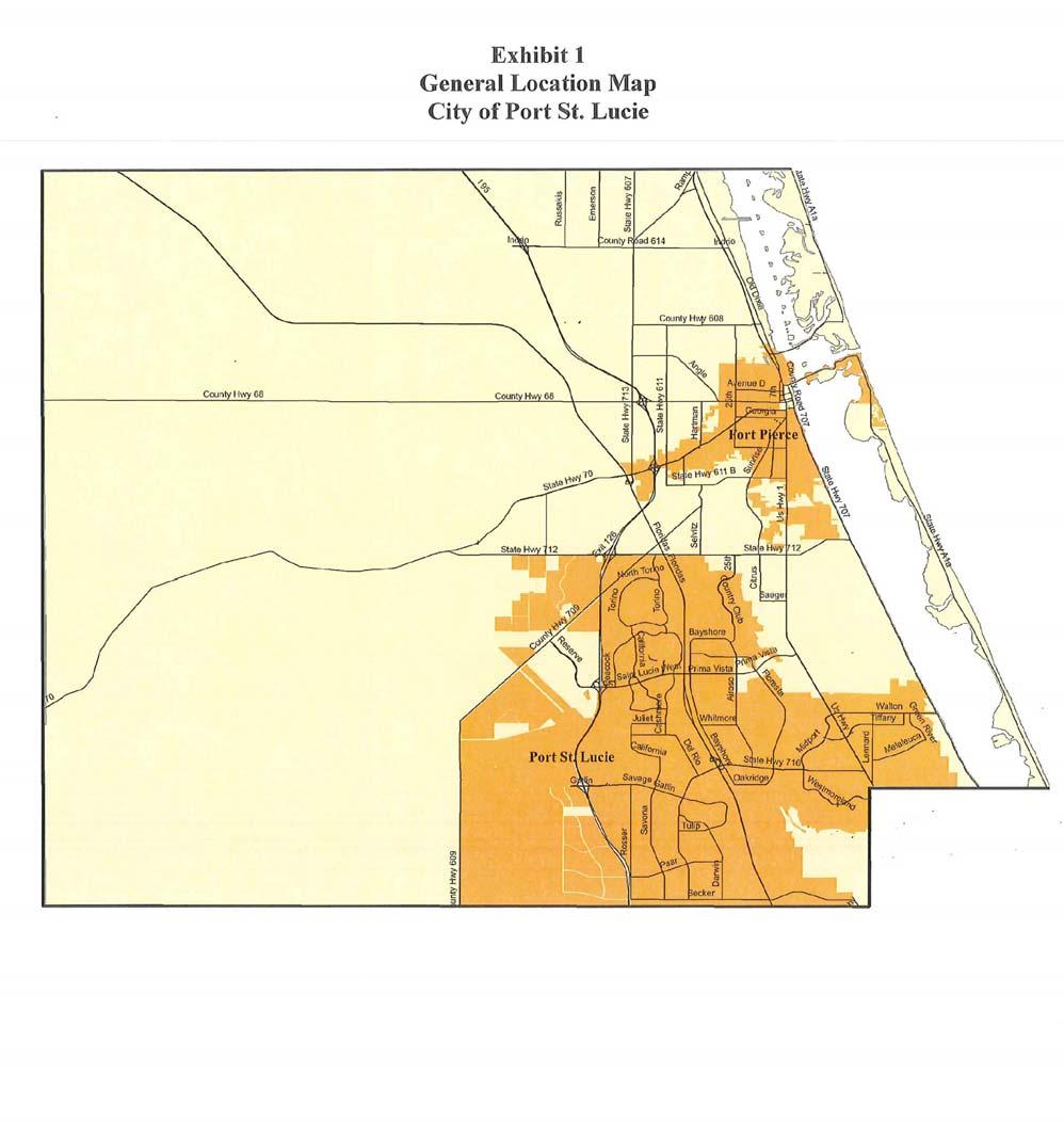
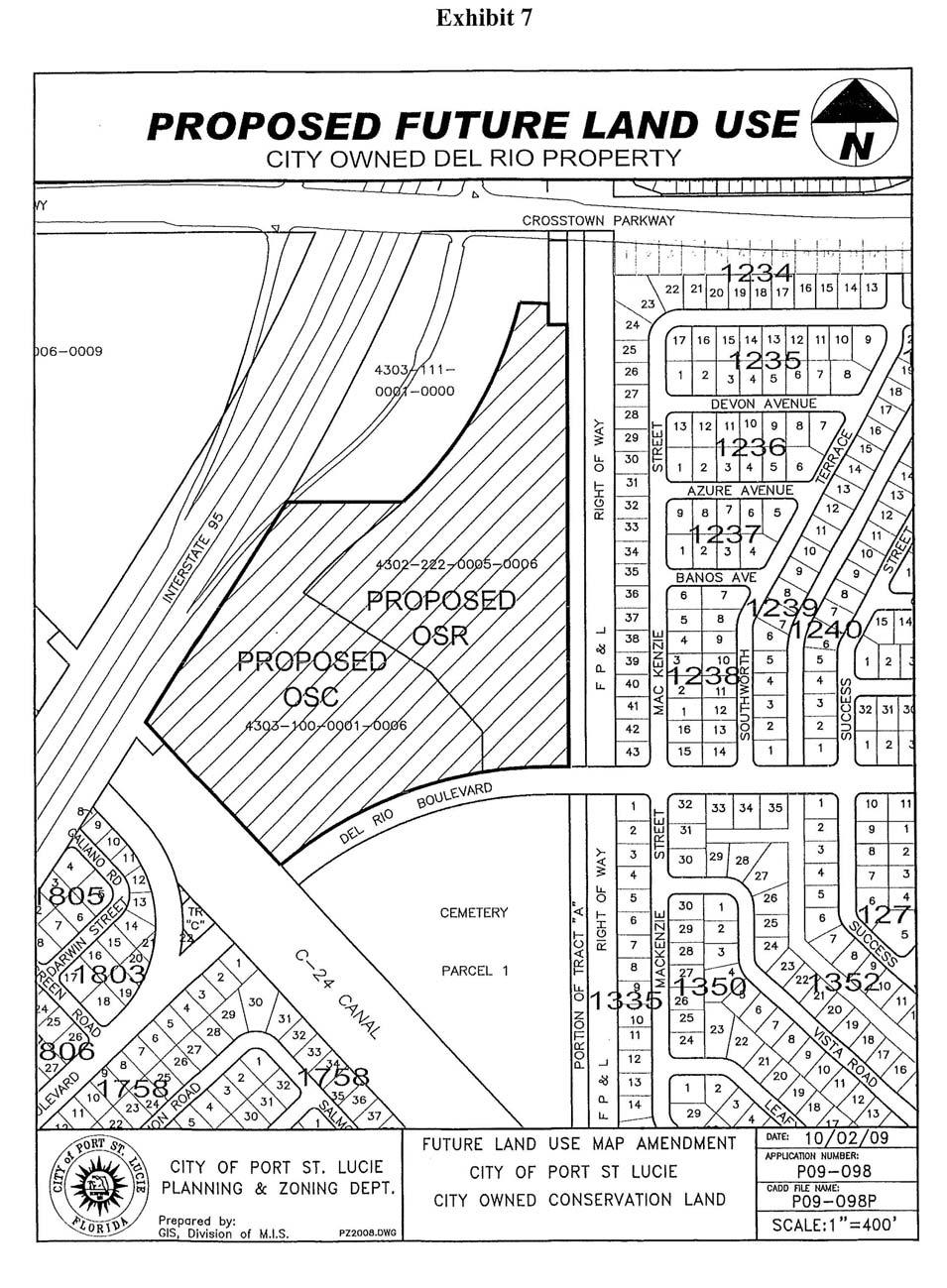
1 TREASURE COAST REGIONAL PLANNING COUNCIL M E M O R A N D U M To: Council Members AGENDA ITEM 5H From: Date: Subject: Staff February 19, 2010 Regional Planning Council Meeting Local Government Comprehensive Plan Review Draft Amendments to the City of Port St. Lucie Comprehensive Plan DCA Reference No Introduction The Local Government Comprehensive Planning and Land Development Regulation Act, Chapter 163, Florida Statutes, requires that the Treasure Coast Regional Planning Council (TCRPC) review local government comprehensive plan amendments prior to their adoption. Under the provisions of this law, the Department of Community Affairs (DCA) prepares an Objections, Recommendations, and Comments (ORC) Report on a proposed amendment only if requested to do so by the local government, the regional planning council, an affected person, or if an ORC Report is otherwise deemed necessary by the DCA. If an ORC Report is to be prepared, then the TCRPC must provide DCA with its findings of consistency or inconsistency with the Strategic Regional Policy Plan (SRPP), and provide any comments and recommendations for modification on the proposed amendments within 30 days of its receipt. Background The City of Port St. Lucie has proposed two amendments to the Future Land Use Map (FLUM) of the City Comprehensive Plan. The City has requested a formal review of the amendments by the DCA. Evaluation Information about the two FLUM amendments is contained in Table 1. The locations of the subject properties and other information is shown in the exhibits. According to the City, both of these properties were given to the City for upland habitat preservation purposes. Both properties are identified as City-owned conservation land in the City of Port St. Lucie Conservation Lands Management Acquisition Plan, adopted by the City Council on September 14, 2009.
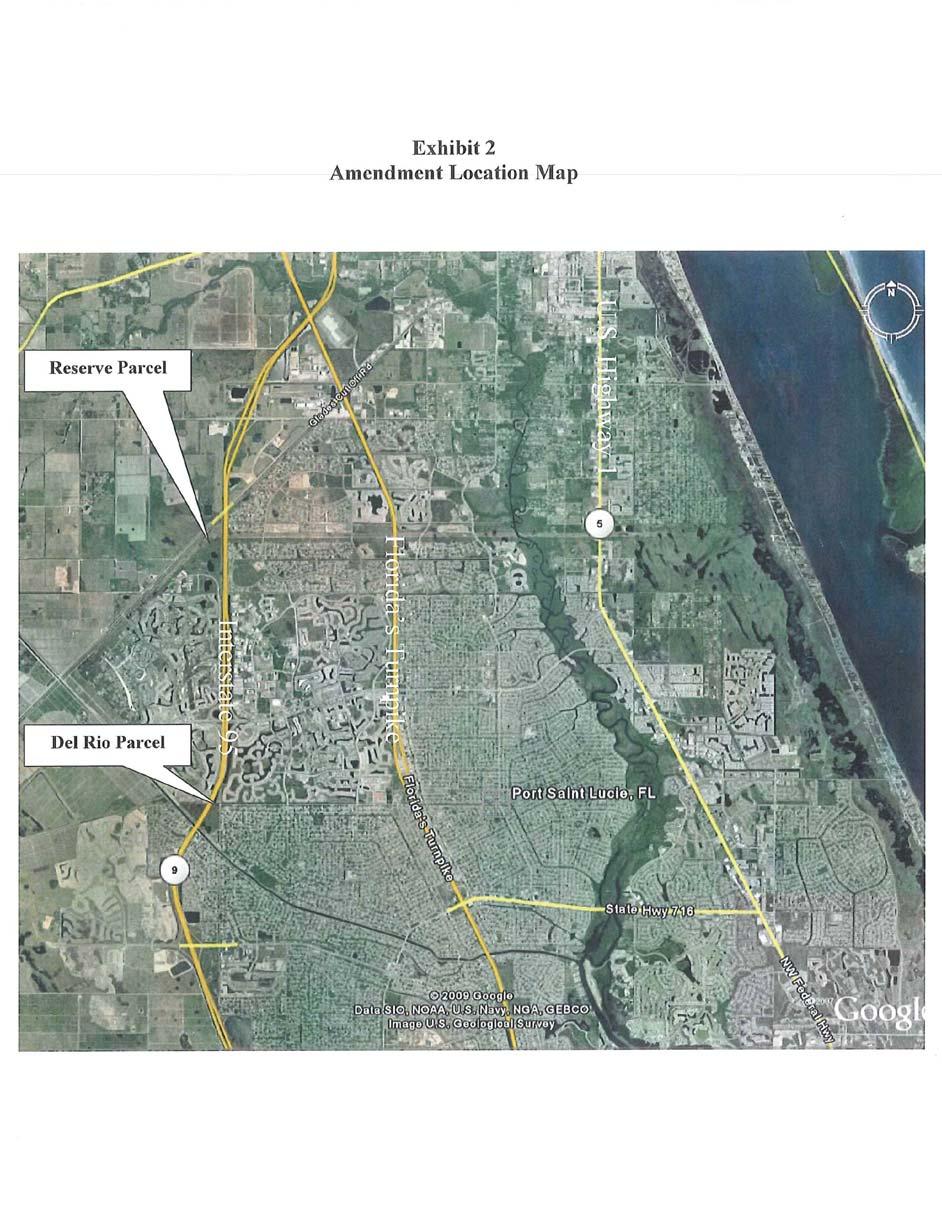
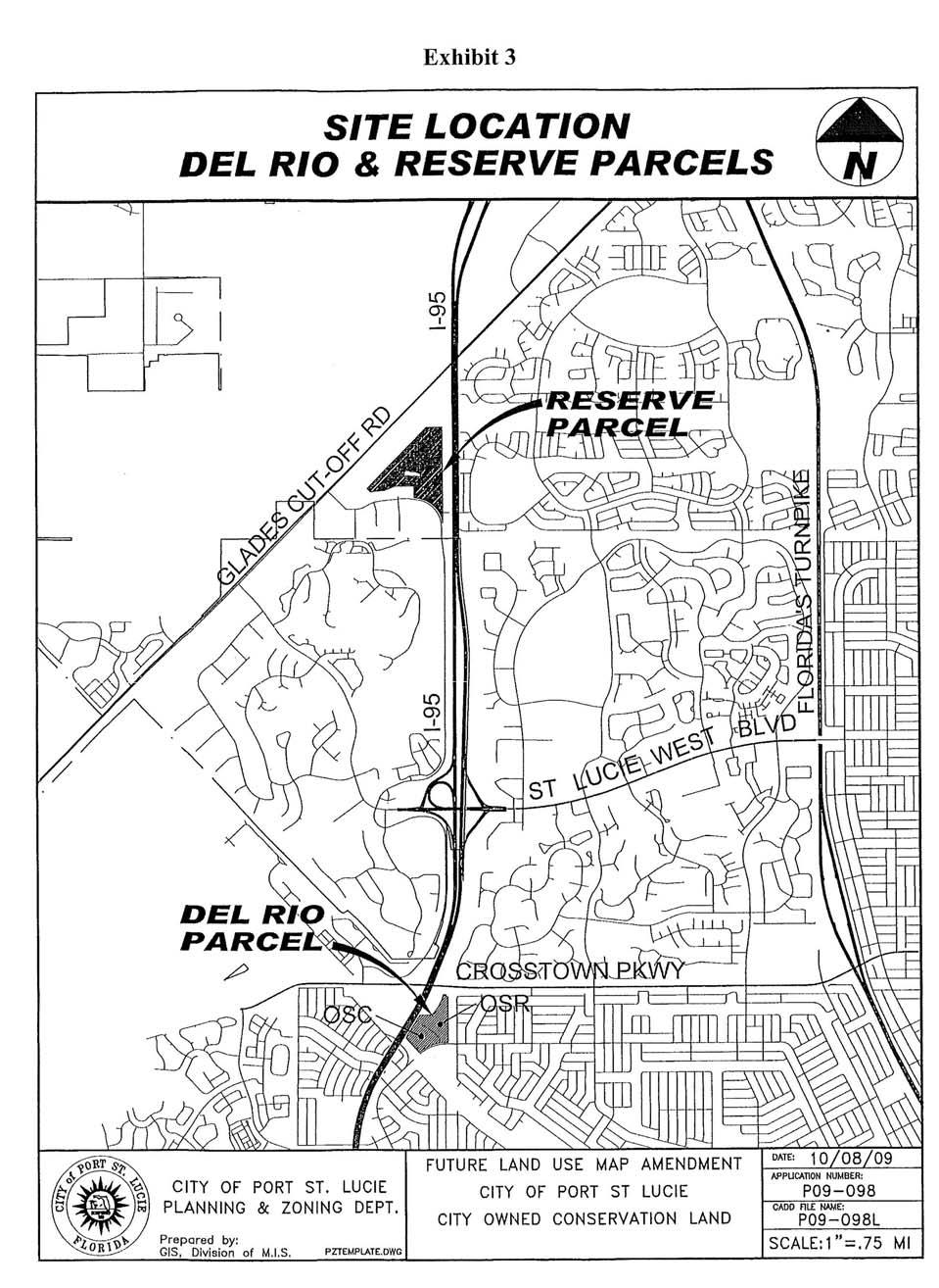
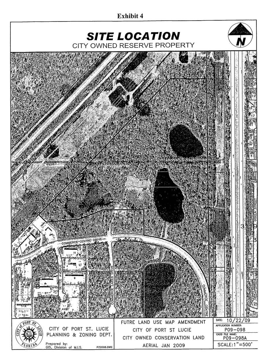
2 Table 1 Proposed Amendments to the Future Land Use Map City of Port St. Lucie Comprehensive Plan DCA Reference No Amendment Number/Name Approx. Acreage Current FLUM Designation Reserve Parcel 94.5 Open Space Recreation Proposed FLUM Designation Open Space Conservation Del Rio Parcel 35.3 Utility Open Space Recreation (19.0 acres) Approximate Location West of I-95, east of Glades Cut-Off Road, north of Commerce Center Drive. Southeast quadrant of I-95/ Crosstown Parkway Interchange Total: Utility Open Space Recreation Open Space Conservation Open Space Conservation (16.3 acres) Key to FLUM Designations Lands that accommodate major public and private utilities Sites designated for existing or future parks or neighborhood preserve areas with limited development potential Areas to be maintained primarily on the natural state. Can also be assigned to areas designated for erosion prevention, flood and drainage areas. A. FLUM Amendments 1. Reserve Parcel This 94.5 acre parcel is located immediately west of I-95 and between Glades Cut-Off Road and Commerce Center Drive (see Exhibits 2 through 5). The preservation of this property as upland habitat is required as part of the Reserve Development of Regional Impact (DRI) and the Settlement Agreement between St. Lucie County and Reserve Homes, Ltd., L.P. The use of the land is restricted to preservation and passive recreation. The current FLUM designation is Open Space Recreation. The proposed designation is Open Space Conservation. Surrounding uses include a large Florida Power and Light Company right-of-way to the north and west, I-95 to the east, and Commerce Center Drive with the Reserve DRI beyond to the south. The FLUM designations on surrounding properties are Utilities to the north, east and west, and Commercial Service beyond Commerce Center Drive to the south. 2
3 2. Del Rio Parcel The 35.3 acre site is located immediately east of I-95 and south of the Crosstown Parkway interchange (see Exhibits 2, 6 and 7). The property serves as off-site upland habitat as part of the development order conditions for the St. Lucie West DRI. However, more than half of the property is leased for use as a paint ball park. The current FLUM designation is Utilities. The proposed FLUM designations are Open Space Recreation (19.0 acres) and Open Space Conservation (16.4 acres). The existing land uses on surrounding properties include the Crosstown Parkway to the north, residential development to the east, a cemetery to the south and I-95 to the west. The FLUM designations on surrounding lands include Utility to the north and east, Institutional to the south and General Commercial across I-95 to the west. Extrajurisdictional Impacts Under the informal agreement facilitated by the TCRPC, local governments in the northern three counties of the region are to provide copies of amendment materials to other local governments that have expressed an interest in receiving such materials. The City provided copies of the amendment materials to all surrounding local governments. Council sent a memorandum to St. Lucie County, Martin County and the City of Fort Pierce on December 2, 2009, seeking comments on the potential for negative extrajurisdictional impacts as a result of the proposed amendments. A letter was received from the St. Lucie County Growth Management Department dated December 22, 2009 (see Attachment A). The County has no objections to the proposed amendments. Effects on Significant Regional Resources or Facilities Analysis of the proposed amendments indicates that they would not have adverse effects on significant regional resources or facilities. Analysis of Consistency with Strategic Regional Policy Plan Comments/Recommendation for Modification 1. The 35.3 acre Del Rio parcel is to serve as off-site upland habitat mitigation for the St. Lucie West DRI. According to the development order for the DRI, (Condition 12 under Habitat, Wetlands, Vegetation and Wildlife of Resolution 07-R40), the habitat to be preserved includes canopy, understory, and ground cover. Uses are to be limited to preservation and passive recreational. However, the City has leased part of this land for a paint ball park, and now proposes to designate that area (19.0 acres) as Open Space Recreation. This appears to be inconsistent with the DRI development order. 3
4 Recommendation for Modification: The City has allowed a portion of the land that was required to be preserved as upland habitat to be impacted by the activities of a paint ball park. This has included some clearing and other impacts. If the land was given to the City by the developer of the St. Lucie West DRI, then the City should be responsible for acquiring and assigning a FLUM designation of Open Space Conservation to an additional 19.0 acres which will serve to meet the requirements of the upland habitat preservation for the DRI. NOTE: At the February 19, 2010 meeting, City of Port St. Lucie Mayor Patricia Christensen indicated that the City had acquired in excess of 19 acres of property that is going to be designated or has been designated as Open Space Conservation. Consistency with Strategic Regional Policy Plan The contract agreement with the DCA requires the TCRPC to include a determination of consistency with the SRPP as part of the written report to be submitted to the DCA. The TCRPC finds the proposed amendments to be CONSISTENT with the SRPP. Recommendation The Treasure Coast Regional Planning Council should adopt the above comments and instruct staff to transmit the report to the Department of Community Affairs. Attachments 4
5
6
7
8
9
10
11
12
13

14
15
DRAFT Subject to Modifications
 TREASURE COAST REGIONAL PLANNING COUNCIL M E M O R A N D U M To: Council Members AGENDA ITEM 5P From: Date: Subject: Staff February 20, 2009 Council Meeting Local Government Comprehensive Plan Review Draft
TREASURE COAST REGIONAL PLANNING COUNCIL M E M O R A N D U M. To: Council Members AGENDA ITEM 5H
 TREASURE COAST REGIONAL PLANNING COUNCIL M E M O R A N D U M To: Council Members AGENDA ITEM 5H From: Date: Subject: Staff October 17, 2008 Council Meeting Local Government Comprehensive Plan Review Draft
TREASURE COAST REGIONAL PLANNING COUNCIL M E M O R A N D U M. To: Council Members AGENDA ITEM 5I
 TREASURE COAST REGIONAL PLANNING COUNCIL M E M O R A N D U M To: Council Members AGENDA ITEM 5I From: Date: Subject: Staff December 12, 2008 Council Meeting Local Government Comprehensive Plan Review Town
TREASURE COAST REGIONAL PLANNING COUNCIL M E M O R A N D U M. To: Council Members AGENDA ITEM 4B15
 TREASURE COAST REGIONAL PLANNING COUNCIL M E M O R A N D U M To: Council Members AGENDA ITEM 4B15 From: Date: Subject: Staff May 18, 2018 Council Meeting Local Government Comprehensive Plan Review Draft
DRAFT Subject to Modifications
 DRAFT Subject to Modifications TREASURE COAST REGIONAL PLANNING COUNCIL M E M O R A N D U M To: Council Members AGENDA ITEM 7C8 From: Date: Subject: Staff January 20, 2017 Council Meeting Local Government
TREASURE COAST REGIONAL PLANNING COUNCIL M E M O R A N D U M. To: Council Members AGENDA ITEM 4B3
 Revision: 3-15-19 TREASURE COAST REGIONAL PLANNING COUNCIL M E M O R A N D U M To: Council Members AGENDA ITEM 4B3 From: Staff Date: March 8, 2019 Subject: Local Government Comprehensive Plan Review Draft
TREASURE COAST REGIONAL PLANNING COUNCIL M E M O R A N D U M. To: Council Members AGENDA ITEM 8B5
 TREASURE COAST REGIONAL PLANNING COUNCIL M E M O R A N D U M To: Council Members AGENDA ITEM 8B5 From: Date: Subject: Staff February 17, 2017 Council Meeting Local Government Comprehensive Plan Review
DRAFT Subject to Modifications
 DRAFT Subject to Modifications TREASURE COAST REGIONAL PLANNING COUNCIL M E M O R A N D U M To: Council Members AGENDA ITEM 7C10 From: Date: Subject: Staff January 20, 2017 Council Meeting Local Government
TREASURE COAST REGIONAL PLANNING COUNCIL M E M O R A N D U M. To: Council Members AGENDA ITEM 3I
 TREASURE COAST REGIONAL PLANNING COUNCIL M E M O R A N D U M To: Council Members AGENDA ITEM 3I From: Date: Subject: Staff December 8, 2017 Council Meeting Local Government Comprehensive Plan Review Draft
DRAFT Subject to Modifications
 TREASURE COAST REGIONAL PLANNING COUNCIL M E M O R A N D U M DRAFT Subject to Modifications To: Council Members AGENDA ITEM 5F From: Date: Subject: Staff September 17, 2010 Council Meeting Local Government
MEMORANDUM AGENDA ITEM #6c
 South Florida Regional Planning Council MEMORANDUM AGENDA ITEM #6c DATE: FEBRUARY 1, 2010 TO: FROM: SUBJECT: COUNCIL MEMBERS STAFF CITY OF PARKLAND PROPOSED COMPREHENSIVE PLAN AMENDMENT (ALTERNATIVE REVIEW)
DRAFT Subject to Modifications TREASURE COAST REGIONAL PLANNING COUNCIL
 DRAFT Subject to Modifications TREASURE COAST REGIONAL PLANNING COUNCIL M E M O R A N D U M To: Council Members AGENDA ITEM 7C From: Date: Subject: Staff June 22, 2007 Council Meeting Local Government
SUBJECT: LOCAL GOVERNMENT COMPREHENSIVE PLAN PROPOSED AND ADOPTED AMENDMENT CONSENT AGENDA
 MEMORANDUM AGENDA ITEM #IV.C DATE: APRIL 15, 2019 TO: FROM: COUNCIL MEMBERS STAFF SUBJECT: LOCAL GOVERNMENT COMPREHENSIVE PLAN PROPOSED AND ADOPTED AMENDMENT CONSENT AGENDA Pursuant to the 1974 Interlocal
Chapter 5: Natural Resources and Environment
 NATURAL RESOURCES AND ENVIRONMENT 5-1 5 Chapter 5: Natural Resources and Environment BACKGROUND AND INTENT Urban expansion represents the greatest risk for the future degradation of existing natural areas,
DRAFT MAP AMENDMENT FLU 04-4
 DRAFT MAP AMENDMENT FLU 04-4 SW 24 TH AVENUE ROADWAY CORRIDOR The University of Florida participates with the Metropolitan Transportation Planning Organization (MTPO) in its responsibilities for the continuing,
INTERGOVERNMENTAL COORDINATION ELEMENT
 Goals, Objectives and Policies COORDINATION ELEMENT GOAL 8.1.: ESTABLISH EFFECTIVE COORDINATION MEASURES AMONG ALL PERTINENT PUBLIC AND QUASI-PUBLIC ENTITIES SO TO BEST MAINTAIN PALM BEACH GARDENS' QUALITY
DRAFT Subject to Modifications
 DRAFT Subject to Modifications TREASURE COAST REGIONAL PLANNING COUNCIL M E M O R A N D U M To: Council Members AGENDA ITEM 10 From: Date: Subject: Staff February 19, 2016 Council Meeting Local Government
Old Brick Township DRI Recommendation Report
 Old Brick Township DRI Recommendation Report City of Palm Coast Presented to NEFRC Planning and Growth Management; Board of Directors July 8, 2010 Recommendation #1 Conversion table limited by transportation
CITY OF VACAVILLE PLANNING COMMISSION Agenda Item No. G.1 STAFF REPORT February 21, 2012 BRIGHTON LANDING SPECIFIC PLAN & DEVELOPMENT PROJECT
 CITY OF VACAVILLE PLANNING COMMISSION Agenda Item No. G.1 STAFF REPORT February 21, 2012 Staff Contact: Fred Buderi (707) 449-5307 TITLE: PURPOSE: BRIGHTON LANDING SPECIFIC PLAN & DEVELOPMENT PROJECT INFORMATIONAL
RECREATION AND OPEN SPACE ELEMENT GOALS, OBJECTIVES, AND POLICIES
 RECREATION AND OPEN SPACE ELEMENT GOALS, OBJECTIVES, AND POLICIES Goal 7 To provide park facilities, recreation programs, and open space resources that are safe, adequate, and accessible to all City residents,
Joe Pool Lake Lake Master Plan Public Information Meeting Presentation of Final Draft Revision July 31, 2018
 Joe Pool Lake Lake Master Plan Public Information Meeting Presentation of Final Draft Revision July 31, 2018 Presented By Jeremy Spencer Lake Manager U.S. Army Corps of Engineers Fort Worth District US
Parks, Trails, and Open space Element
 Parks, Trails, and Open space Element Parks, Trails, and Open Space element Parks, Recreation, and Open Space are important components of the quality of life desired by the residents of Elk Grove. This
Osceola County Board of County Commissioners 1 Courthouse Square, Suite 1100 Kissimmee, FL
 1/10/11 Item Number DRI08-0006 Osceola County Board of County Commissioners 1 Courthouse Square, Suite 1100 Kissimmee, FL 34741 407-742-0200 Applicant & Owner Center Lake Properties, LLLP and Formally
Parks, Trails, and Open Space Element
 P arks, Recreation, and Open Space are important components of the quality of life desired by the residents of Elk Grove. This Element of the General Plan addresses the City s goals, policies, and actions
AWH REPORT OF THE PLANNING AND DEVELOPMENT DEPARTMENT FOR APPLICATION FOR REZONING ORDINANCE TO PLANNED UNIT DEVELOPMENT
 AWH REPORT OF THE PLANNING AND DEVELOPMENT DEPARTMENT FOR APPLICATION FOR REZONING ORDINANCE TO PLANNED UNIT DEVELOPMENT MAY 8, 2014 The Planning and Development Department hereby forwards to the Planning
MEMORANDUM AGENDA ITEM #IV.C
 MEMORANDUM AGENDA ITEM #IV.C DATE: NOVEMBER 27, 2017 TO: FROM: COUNCIL MEMBERS STAFF SUBJECT: LOCAL GOVERNMENT COMPREHENSIVE PLAN PROPOSED AND ADOPTED AMENDMENT CONSENT AGENDA Pursuant to Section 163.3184,
CONSERVATION ELEMENT GOALS, OBJECTIVES, AND POLICIES
 CONSERVATION ELEMENT GOALS, OBJECTIVES, AND POLICIES Goal 4 To conserve, manage, appropriately use and protect the natural resources of the City ensuring continued resource availability and environmental
ADOPTION OF THE REVISED OPEN SPACE AND CONSERVATION ELEMENT OF THE GENERAL PLAN
 TO: FROM: SUBJECT: Honorable Mayor and City Council Planning Department ADOPTION OF THE REVISED OPEN SPACE AND CONSERVATION ELEMENT OF THE GENERAL PLAN RECOMMENDATION: It is recommended that the City Council:
CITY OF TARPON SPRINGS DCA#11-1AR
 Agenda Item #3.H.2 05/09/11 TAMPA BAY REGIONAL PLANNING COUNCIL LOCAL GOVERNMENT COMPREHENSIVE PLAN ADOPTED AMENDMENT REPORT CITY OF TARPON SPRINGS DCA#11-1AR 1 ADOPTED WITH THE FOLLOWING CHANGES: Ordinance
HOUSING ELEMENT GOALS, OBJECTIVES, AND POLICIES
 HOUSING ELEMENT GOALS, OBJECTIVES, AND POLICIES Goal 6 Maintain and enhance the supply of decent, safe, energy efficient and affordable housing and maximize viable options and opportunities for present
TRANSPORTATION ELEMENT GOALS, OBJECTIVES, AND POLICIES
 TRANSPORTATION ELEMENT GOALS, OBJECTIVES, AND POLICIES GOAL 2 The City shall provide a safe, convenient, effective, and energy efficient multimodal transportation system which is coordinated with the Future
Right-of-Way Acquisitions and Relocations Technical Memorandum
 Right-of-Way Acquisitions and Relocations Technical Memorandum Southeast Extension Project Lincoln Station to RidgeGate Parkway Prepared for: Federal Transit Administration Prepared by: Denver Regional
City Council of Fort Walton Beach ENGINEERING & UTILITY SERVICES MEMORANDUM
 City Council of Fort Walton Beach ENGINEERING & UTILITY SERVICES MEMORANDUM To: From: Michael D. Beedie, City Manager Tim Bolduc, Engineering and Utilities Services Director Date: April 26, 2016 Subject:
5 EIS Process, Content, and Exhibits
 5 EIS Process, Content, and Exhibits 5.1 Draft and Final Environmental Impact Statements The recent SW LRT process began with a comprehensive analysis of alternative corridors, the results of which form
North Central Florida Regional Planning Council
 North Central Florida Regional Planning Council 1 2015 Growth Management Legislation Sandra Joseph, Senior Planner Local Government Comprehensive Planning June 12, 2015 2 Overview Growth Management Omnibus
Memorandum Planning. Thursday, January 8, 2015
 Memorandum Planning Thursday, January 8, 2015 7.A. To: Coastal Advisory Committee From John Ciampa, Associate Planner Subject: Review Draft Local Coastal Program Copies: James Pechous, City Planner Purpose
14. INTERGOVERNMENTAL COORDINATION ELEMENT
 14. Introduction This Intergovernmental Coordination Element includes Goals, Objectives and Policies (GOP) that apply to the main campus and Alachua County Satellite Properties. The Intergovernmental Coordination
#3) DA AMENDMENT TO DEVELOPMENT AGREEMENT PARK HIGHLANDS - WEST PUBLIC HEARING
 DA AMENDMENT TO DEVELOPMENT AGREEMENT PARK HIGHLANDS - WEST PUBLIC HEARING") #3) DA-03-16 AMENDMENT TO DEVELOPMENT AGREEMENT PARK HIGHLANDS - WEST PUBLIC HEARING STAFF REPORT To: Planning Commission Meeting date: May 11, 2016 Item: DA-03-16 Prepared by: Robert Eastman GENERAL INFORMATION:
#3) DA-03-16 AMENDMENT TO DEVELOPMENT AGREEMENT PARK HIGHLANDS - WEST PUBLIC HEARING STAFF REPORT To: Planning Commission Meeting date: May 11, 2016 Item: DA-03-16 Prepared by: Robert Eastman GENERAL INFORMATION:
Planning Proposal under section 55 of the EP&A Act
 FOR PUBLIC EXHIBITION [Brief description] Monday 10 October to Monday 27 October 2014 Planning Proposal under section 55 of the EP&A Act Port Macquarie-Hastings LEP 2011 (Amendment No 32) Mixed land zone
KING GEORGE COUNTY BOARD OF SUPERVISORS. Update on Governor Harry W. Nice Bridge Replacement Project February 6, 2018
 KING GEORGE COUNTY BOARD OF SUPERVISORS Update on Governor Harry W. Nice Bridge Replacement Project February 6, 2018 Tonight s Goals Project Design and Schedule Update Noise Analysis Results Determine
Narcoossee Roadway Corridor
 Community Meeting Narcoossee Roadway Corridor April 5, 2012 Meeting Agenda Purpose of Meeting Continuation of Study Update Process (Previous Meetings Oct. & Nov., 2011) Tonight s Objective Review Proposals
RECREATION, OPEN SPACE AND GREENWAYS ELEMENT GOALS, OBJECTIVES, AND POLICIES
 RECREATION, OPEN SPACE AND GREENWAYS ELEMENT GOALS, OBJECTIVES, AND POLICIES GOAL R-1: DEVELOP A RECREATION, OPEN SPACE AND GREENWAYS SYSTEM AS AN INTEGRAL COMPONENT OF AN OVERALL, COUNTY-WIDE ECONOMIC
Regional Context Statement
 Regional Context Statement REGIONAL CONTEXT STATEMENT 3. REGIONAL CONTEXT STATEMENT In 1995, the Provincial Government passed into law the Growth Strategies Act. The purpose of this provincial initiative
PLANNED UNIT DEVELOPMENT Date: April 5, 2018
 PLANNED UNIT DEVELOPMENT Date: April 5, 2018 DEVELOPMENT NAME SUBDIVISION NAME LOCATION Robert Myers Robert Myers 2955 and 2989 Dauphin Street (Southeast corner of Dauphin Street and Sage Avenue) CITY
DOMINION BOULEVARD CORRIDOR STUDY AND ECONOMIC DEVELOPMENT STRATEGIC PLAN A MODEL FOR CHESAPEAKE S FUTURE
 DOMINION BOULEVARD CORRIDOR STUDY AND ECONOMIC DEVELOPMENT STRATEGIC PLAN A MODEL FOR CHESAPEAKE S FUTURE Overview I. Draft Plan Process II. Draft Plan Overview a. Market Analysis b. Master Land Use Plan
Planning for Staten. Habitat Restoration and Green Infrastructure. Island s North Shore
 Habitat Restoration and Green Infrastructure Planning for Staten Island s North Shore Community Board 1 March 1, 2018 NYC Parks Forestry, Horticulture, and Natural Resources Funded by the NYS Department
Commercial Launch Site Addendum to Wetland Mitigation Plan. Revision 2. April 25, SpaceX Proprietary
 Commercial Launch Site Addendum to Wetland Mitigation Plan Revision 2 April 25, 2017 SpaceX Proprietary Contents 1.0 Project Information... 1 1.1 Background... 1 2.0 Compensatory Mitigation... 2 2.1 Goals
Community Development Rezoning Report REZ16-018
 Community Development Rezoning Report Planning Commission Board of Supervisors March 1, 2016 March 23, 2016 Applicant Tax Map Id Present Zoning Proposed Zoning Location Medical Center 125-(17)- L1, 125-(17)-
Staff will be providing an overview of the project need, purpose and intent for consideration as part of the Amendment cycle.
 Agenda Item D-2 City of Tacoma Planning and Development Services To: Planning Commission From: Stephen Atkinson, Planning Services Division Subject: Open Space Corridors Project Meeting Date: March 1,
PLANNED UNIT DEVELOPMENT STAFF REPORT Date: June 2, 2016
 # 9 ZON2016-01032 PLANNED UNIT DEVELOPMENT STAFF REPORT Date: June 2, 2016 DEVELOPMENT NAME JJT Properties LLC LOCATION 1147 & 1151 East I-65 Service Road South and 1180 Sledge Drive (Southeast corner
Pine Flat Lake Master Plan Update FACT SHEET September 2014
 Pine Flat Lake Master Plan Update FACT SHEET September 2014 PURPOSE AND OBJECTIVE The U.S. Army Corps of Engineers Sacramento District is revising the 1976 Pine Flat Lake Master Plan and is seeking public
CHAPTER 2 SUMMARY 1. PROJECT SUMMARY DATA
 CHAPTER 2 SUMMARY This is an Initial Study format used to determine, pursuant to CEQA Guidelines Section 15177, whether a project 1) is within the scope of a Master EIR (MEIR), 2) may result in additional
ARLINGTON COUNTY, VIRGINIA. County Board Agenda Item Meeting of June 16, 2018
 ARLINGTON COUNTY, VIRGINIA County Board Agenda Item Meeting of June 16, 2018 DATE: June 7, 2018 SUBJECT: Z-2604-18-1 Rezoning from R-6 and R-5 Single Family Residential Districts to S-3A Special District
Subject: 30 Otis Street, Evaluation of Shadow on Proposed 11th and Natoma Park
 Date: September 5, 2018 To: Recreation and Park Commission Capital Committee Through: Philip A. Ginsburg, General Manager Toks Ajike, Director, Capital & Planning Division From: Brian Stokle, Planner,
PLANNING APPROVAL & PLANNED UNIT DEVELOPMENT Date: November 2, 2017
 PLANNING APPROVAL & PLANNED UNIT DEVELOPMENT Date: November 2, 2017 DEVELOPMENT NAME LOCATION Mobile Christian School 5900 Cottage Hill Road (North side of Cottage Hill Road, 230 ± West of Freemont Drive
Micco Park Village Development
 FOR SALE Call For Pricing Micco Park Village Development Proposed Project Property Details Micco Park Village Development PRICE Call For Pricing A monumental development opportunity of a lifetime! The
City of Fort Lupton Site Plan Process
 Form WKBK001 City of Fort Lupton Site Plan Process Purpose The Site Plan process is meant to promote orderly and sound development standards as they apply to the City. These site development standards
Staff Report and Recommendation
 Community Planning and Development Planning Services 201 W. Colfax Ave., Dept. 205 Denver, CO 80202 p: 720.865.2915 f: 720.865.3052 www.denvergov.org/cpd TO: City Council Neighborhoods and Planning Committee
Environmental Review Part 55 Floodplain Management Subpart C. 8-Step Decision Making Process
 Environmental Review Part 55 Floodplain Management Subpart C 8-Step Decision Making Process - 55.20 Project: Acquisition and Demolition of a Blighted Structure - 1 North Strawberry Avenue, Marietta PA
MONTGOMERY COUNTY PLANNING DEPARTMENT
 MONTGOMERY COUNTY PLANNING DEPARTMENT THE MARYLAND-NATIONAL CAPITAL PARK AND PLANNING COMMISSION MCPB Item No.: Date: 5-03-18 Pike and Rose, Phase I: Site Plan Amendment No. 82012002D Rhoda Hersson-Ringskog,
4.0 Future Land Use Element
 4.0 The Florida Agricultural and Mechanical University (FAMU) represents existing and proposed development patterns within the campus boundaries to be coordinated and not conflict with the adjacent areas
LEGAL NOTICE. City of Tacoma Determination of Environmental Nonsignificance. Fred Wagner, Wagner Development. Demolition of Manitou school buildings
 LEGAL NOTICE City of Tacoma Determination of Environmental Nonsignificance Lead Agency: Applicant: Proposal: Location: City of Tacoma Fred Wagner, Wagner Development Demolition of Manitou school buildings
Public Hearing. Charlotte County-Punta Gorda MPO - Meeting Rooms A and B March 14, open house at 4 p.m., formal presentation at 5 p.m.
 Public Hearing Charlotte County-Punta Gorda MPO - Meeting Rooms A and B March 14, 2019 open house at 4 p.m., formal presentation at 5 p.m. Welcome to the Public Hearing for the Harborview Road (CR 776)
SUMMARY. Support the Southeast Arkansas Regional Intermodal Facility.
 SUMMARY THE I-69 LOCATION STUDY The proposed I-69 Location Study from El Dorado to McGehee, Arkansas, represents one section (Section of Independent Utility No. 13) of the nationally designated I-69 Corridor
CITY OF PORT ST LUCIE
 CITY OF PORT ST LUCIE COUNCIL AGENDA MEMORANDUM 7AA Agenda Item #: Meeting Date: 8/ 14/ 17 TO: VIA: Mayor and City ouncil Russ Blackburn, ity Manager Patricia Roebling, PE, Assistant City Mana FROM: Patricia
Town of Rico Three Mile Plan for Annexation
 Town of Rico Three Mile Plan for Annexation 10.20.2010 Adopted by Resolution 2010-2 Produced with funding support from the Colorado Department of Local Affairs 2 Content Guide Introduction. 3 Annexation
TO: CITY COUNCIL DATE: MARCH 23,2009
 Report TO: CITY COUNCIL DATE: MARCH 23,2009 FROM: CITY MANAGER SUBJECT: MASTER DEVELOPMENT PLAN AMENDMENT FOR PASADENA CHRISTIAN SCHOOL AT 1515 NORTH LOS ROBLES AVENUE AND GENERAL PLAN AMENDMENT AND ZONE
Goal 1: To Encourage the Orderly, Harmonious and Judicious Use of University Resources in the Development of University Land.
 2.0 Future Land Use Goal 1: To Encourage the Orderly, Harmonious and Judicious Use of University Resources in the Development of University Land. Objective 1.1: Make available future building sites that
CAMPUS MASTER PLAN, AMENDMENTS
 CAMPUS MASTER PLAN AMENDMENTS CAMPUS MASTER PLAN, 2015-2025 AMENDMENTS OCTOBER 2016 PLANNING, DESIGN & CONSTRUCTION DIVISION AMENDMENTS UNIVERSITY OF FLORIDA COMPREHENSIVE MASTER PLAN OCTOBER 2016 1. Acreage
Description of Preferred Alternative
 Chapter 2 Description of Preferred Alternative 2.1 Introduction This chapter of the programmatic Sammamish Town Center Sub-area Plan Final EIS provides a more detailed description of the Preferred Alternative
DRAFT SECTION 4(f) EVALUATION INTERSTATE 73 FEIS: I-95 to I-73/I-74 in North Carolina
 EVALUATION INTERSTATE 73 FEIS: I-95 to I-73/I-74 in North Carolina") DRAFT SECTION 4(f) EVALUATION INTERSTATE 73 FEIS: I-95 to I-73/I-74 in North Carolina 1.0 INTRODUCTION Section 4(f) of the Department of Transportation Act of 1966, 49 U.S.C. 303, requires that prior to
DRAFT SECTION 4(f) EVALUATION INTERSTATE 73 FEIS: I-95 to I-73/I-74 in North Carolina 1.0 INTRODUCTION Section 4(f) of the Department of Transportation Act of 1966, 49 U.S.C. 303, requires that prior to
Subject: Hendry County Evaluation and Appraisal Report Letter of Understanding - Identification of Major Issues
 HENDRY COUNTY PLANNING & ZONING DEPARTMENT POST OFFICE BOX 2340 165 S. LEE STREET LABELLE, FLORIDA 33975 (863) 675-5240 FAX: (863) 675-5317 SUNCOM 744-4750 November 16, 2007 Mr. Mike McDaniel, Chief Office
Mitchell Ranch South MPUD Application for Master Planned Unit Development Approval Project Narrative. Introduction
 Mitchell Ranch South MPUD Application for Master Planned Unit Development Approval Project Narrative Introduction Mitchell Ranch South is a proposed single family (detached) residential development on
CHATHAM COUNTY S PATH TO SUSTAINABILITY - THE NATURAL RESOURCES SIDE
 CHATHAM COUNTY S PATH TO SUSTAINABILITY - THE NATURAL RESOURCES SIDE GEORGIA ENVIRONMENTAL CONFERENCE SAVANNAH, GEORGIA AUGUST 23, 2012 Jackie Jackson Teel Chatham County-Savannah Metropolitan Planning
Future Land Use and Transportation
 Planning & Zoning Board Workshop Comprehensive Plan for Village of Estero Future Land Use and Transportation April 6, 2017 January Kick-off Meeting Public Input What do you like about Estero? Location
Watertown City Council
 City of Watertown Watertown City Council April 14 th, 2015 Agenda Item: City Comment on Sun Share CUP Application Request for Action: Motion to Approve City Comments regarding CUP Application Department:
Planning Commission Retreat March 23 rd Comprehensive Plan Update Discussion
 Planning Commission Retreat March 23 rd 2011 Comprehensive Plan Update Discussion Purpose of This Discussion Go Over Key Aspects of the Update Discuss Element By Element Key Concepts Big Ideas What Policies
CITY of WILMINGTON North Carolina
 Item PH4 CITY of WILMINGTON North Carolina P.O. BOX 1810 28402 OFFICE OF THE CITY MANAGER (910) 341-7810 FAX (910) 341-5839 TDD (910) 341-7873 04/20/2010 City Council City Hall Wilmington, North Carolina
Lewisville Lake Master Plan Revision Public Information Meeting May 2 & 4, 2017
 Lewisville Lake Master Plan Revision Public Information Meeting May 2 & 4, 2017 Presented By Rob Jordan Lake Manager U.S. Army Corps of Engineers Fort Worth District US Army Corps of Engineers Purpose
Chapter 10 IMPLEMENTATION RECOMMENDATIONS
 Chapter 10 IMPLEMENTATION RECOMMENDATIONS The recommended land use plan presented in the previous chapter provides a design for the attainment of the urban and rural development and open space preservation
TO: Port of Orcas FROM: Tina Whitman, Science Director SUBJECT: Master Plan Update DATE: September 7, 2018
 TO: Port of Orcas FROM: Tina Whitman, Science Director SUBJECT: Master Plan Update DATE: September 7, 2018 Friends of the San Juans appreciates the opportunity to provide input to the Port of Orcas Master
6. Consistency with Local Plans
 6. Consistency with Local Plans 6.1. Chapter Overview 6.1.1. Introduction This section presents the goals, objectives and policies of municipal, county and state planning entities, as well as known development/redevelopment
2016 Comprehensive Plan Amendments C OMPREHENSIVE P LAN T EXT AND M AP A MENDMENT
 2016 Comprehensive Plan Amendments T EXT A MENDMENTS D ISTILLERIES IN R URAL P OLICIES #844110 LID POLICIES #844112 M AP A MENDMENTS B ETHEL S CHOOL D ISTRICT #844237 P ARKS AND R ECREATION #844305 C OMPREHENSIVE
Dwelling Units Max 12 dwelling units per acre/min 8 dwelling units per acre. Development Mix 80% non residential/20% residential
 13. OSTEEN LOCAL PLAN Background: The Osteen Local Plan area is located in southwest Volusia County along the SR 415 corridor between Lemon Bluff Road and Acorn Lake Road and includes 3,990 acres. The
Northeast Ohio Regional Sewer District Stormwater Management Plan Review Policy
 Northeast Ohio Regional Sewer District Stormwater Management Plan Review Policy Introduction As a component of the Northeast Ohio Regional Sewer District s (District) Regional Stormwater Management Program,
Planning Proposal Charlestown Swim and Leisure Centre LEP Amendment
 Planning Proposal Charlestown Swim and Leisure Centre LEP Amendment Amendment No. 4 to Lake Macquarie Local Environmental Plan 2014 (PP_2014_LAKEM_005_00) Local Government Area: Name of Draft LEP: Lake
Master Plan Objectives and Policies
 Master Plan Objectives and Policies Introduction This chapter identifies the Park issues and recommended policies established by this Master Plan. The issues were identified through meetings with staff,
RRW Stonebrook, LLC Tentative Map Findings
 RRW Stonebrook, LLC Tentative Map Findings FINDING T1: The request conforms to the Master Plan and zoning ordinances. RELATIONSHIP TO THE MASTER PLAN 1. The respective development is located within an
Mayor Leon Skip Beeler and Members of the City Commission. Anthony Caravella, AICP, Director of Development Services
 CITY COMMISSION BRIEFING & Planning Board Report For Meeting Scheduled for June 7, 2012 Inner Room Cabaret Site Plan/Architectural Review Downtown Overlay District/Primary Downtown Area Site Plan Consent
Raystown Lake Master Plan Revision. Public Meeting April 25 & 26, 2018 How does the revision process work?
 Raystown Lake Master Plan Revision Public Meeting April 25 & 26, 2018 How does the revision process work? What is a Master Plan? The Master Plan is the strategic land use management document that guides
PG&E WINTERS GAS OPERATIONS AND TECHNICAL TRAINING CENTER
 PG&E WINTERS GAS OPERATIONS AND TECHNICAL TRAINING CENTER CEQA scoping Meeting March 19 th, 2014 Winters City Council Chambers - 6:30 pm AGENDA FOR THE MEETING 6:30 Welcome (John Donlevy) 6:40 Overview
MAYFIELD WEST SECONDARY PLAN PHASE 2
 MAYFIELD WEST SECONDARY PLAN PHASE 2 Public Open House #3 February 25, 2010 Draft Preferred Land Use Scenario TOWN OF CALEDON PLANNING & DEVELOPMENT DEPARTMENT Open House Agenda TOWN OF CALEDON 1. Welcome
CITY COUNCIL STUDY SESSION MEMORANDUM
 City and County of Broomfield, Colorado CITY COUNCIL STUDY SESSION MEMORANDUM To: From: Prepared by: Mayor and City Council Charles Ozaki, City and County Manager Kevin Standbridge, Deputy City and County
STAFF REPORT FOR STANDARD COASTAL DEVELOPMENT PERMIT #CDP FEBRUARY 26, 2015 CPA - 1 PO BOX 238 APTOS, CA 94001
 STAFF REPORT FOR STANDARD COASTAL DEVELOPMENT PERMIT #CDP 2014-0030 FEBRUARY 26, 2015 CPA - 1 OWNER/APPLICANT: AGENT: REQUEST: HANS HEIM PO BOX 238 APTOS, CA 94001 JAMES HAY PO BOX 762 MENDOCINO, CA 95460
Canyon Lake Master Plan Revision Public Information Meeting March 18, 2016
 Canyon Lake Master Plan Revision Public Information Meeting March 18, 2016 Marcus Schimank Canyon Lake Manager Capital Regional Office U.S. Army Corps of Engineers Fort Worth District US Army Corps of
Glenborough at Easton Land Use Master Plan
 Implementation 114 9.0 IMPLEMENTATION 9.1 OVERVIEW This chapter summarizes the administrative procedures necessary to implement the proposed land use plan, infrastructure improvements, development standards,
Gadsden County Planning Commission Agenda Request
 Date of Meeting: November 16, 2017 To: From: Through: Subject: Gadsden County Planning Commission Agenda Request Honorable Chairperson and Members of the Board Jill A. Jeglie, AICP, Senior Planner Clyde
EAST LAKE TARPON COMMUNITY OVERLAY
 EAST LAKE TARPON COMMUNITY OVERLAY East Lake Tarpon in Pinellas County Florida physical area is defined by the boundaries of the as shown in the map below and legal description in Appendix A. VISION: East
Intergovermental Coordination
 Intergovermental Coordination CITY OF WINTER PARK CHAPTER 8: INTERGOVERNMENTAL COORDINATION ELEMENT INTERGOVERNMENTAL COORDINATION ELEMENT GOAL 8-1: PROVIDE FOR IMPROVED INTERGOVERNMENTAL COORDINATION
Prepared by: Casey Kempenaar, Senior Planner
 CITY OF CITRUS HEIGHTS PLANNING DIVISION STAFF REPORT PLANNING COMMISSION MEETING September 13, 2017 Prepared by: Casey Kempenaar, Senior Planner REQUEST The applicant requests a Design Review Permit Modification