WEST HILL BUSINESS PARK AREA STRUCTURE PLAN
|
|
|
- Theodore Fitzgerald
- 6 years ago
- Views:
Transcription
1 MUNICIPAL DISTRICT OF PEACE NO. 135 WEST HILL BUSINESS PARK AREA STRUCTURE PLAN Prepared by:
2 TABLE OF CONTENTS 1.0 Introduction Purpose of Plan Plan Area Existing Conditions Policy Framework Development Concept Goals of the Plan Land Use Concept Industrial and Commercial Development Country Residential Open Space Transportation and Servicing Road Network Servicing Lot Grading Implementation Phasing Subdivision and Development Amendments to the Plan LIST OF MAPS 1 Location Following Page 1 2 Existing Conditions..... Following Page 1 3 Topography Following Page 2 4 Land Use / Regulation Following Page 3 5 Land Use Concept Following Page 4 6 Transportation Following Page 8 7 Future Regional Transportation Following Page 8 8 Phasing... Following Page11
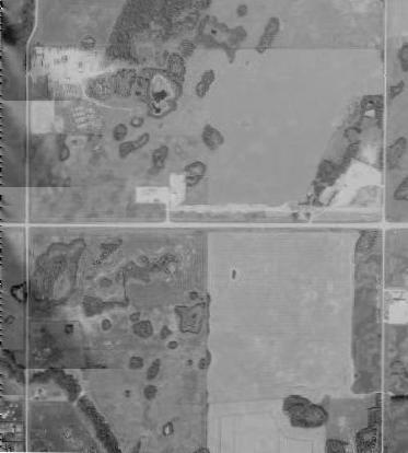
3 1.0 INTRODUCTION 1.1 Purpose of Plan The (ASP) provides a framework for the future development of lands in the Municipal District of Peace No. 135 (MD) west of the Town of Peace River and east of the Peace River Airport. The primary objectives of this Plan are to provide for the development of commercial and industrial uses and to accommodate an opportunity to connect to future services should they be extended to the Plan area. The Plan has been prepared in accordance with the Municipal Government Act (MGA), the Subdivision and Development Regulation, the M.D. of Peace No. 135 Municipal Development Plan (MDP), and the Peace River Intermunicipal Development Plan (IDP). The Plan is consistent with the goals, objectives and policies of the MD and addresses the requirements of Alberta Transportation and Transport Canada with respect to Highway 2 and the Peace River Airport. 1.2 Plan Area The Plan area is located approximately 2.4 km west of the Town of Peace River and 0.5 km east of the Peace River Airport as illustrated in Map 1. The Plan area includes ha of lands bisected by Highway 2 between Range Road 224 to the west and Range Road 223 to the east. The subject lands include the S½ of W5M on the north side of Highway 2 and the N½ of W5M on the south side of Highway 2. The Plan area consists of ten parcels within four quarter sections of land as illustrated in Map 2. The ownership pattern and breakdown of the ten parcels is outlined in Table 1 below. Table 1 Plan Area Composition 1 Legal Owner Area (ha) NW Pt. NW Lot 1, Block 1, Plan NE SW Lot A, Plan 5369NY Lots 1A and 2A, Plan 5370NY Lot 3A, Plan 5370NY SE Road Plans Alberta Ltd. Landowner Landowner D. and C. Freeland Alberta Ltd. Martian Properties Inc. Landowner Landowner Quintel Communications Ltd Total Subject to requirements listed in the Alberta Freedom of Information Act ISL Engineering and Land Services Ltd. 1
4
5
6 1.3 Existing Conditions The subject lands generally slope from an elevation of 570 m in northwest to 550 m in the southeast as illustrated in Map 3. This results in an overall slope of 2%. Natural features consist of numerous small tree stands and minor wetland areas dispersed throughout the Plan area. The most significant natural feature is a coulee that bisects the southwest corner of the Plan area. The coulee serves as a drainage course during the spring and heavy rainfall events, but is otherwise dry most of the year. The Plan area was subject to previous subdivision activity with the creation of six small parcels, two of which remain undeveloped (one industrial and one residential). Development in the Plan area consists of three industrial/commercial operations (bulk fuel station, a trucking operation and a communications company) and one residence in the southwest corner as illustrated in Map 3. The balance of the Plan area is in agricultural production. The agricultural lands in the Plan area are predominantly rated by Canada Land Inventory as 80% Class 2 and 20% Class 4, while the easterly portion of NE 28 is rated at Class 3, all of which by definition is better agricultural land, according to MD planning policy. 1.4 Policy Framework 1.4 M.D. of Peace No. 135 Municipal Development Plan The M.D. of Peace No. 135 Municipal Development Plan (MDP) provides the general policy framework to guide more detailed plans and future development. A primary policy direction of the MDP is to preserve better agricultural land by discouraging subdivision on said lands. However, there are other policies respecting industrial development that also apply: Objective: To support a concentrated pattern of industrial development wherever feasible. The Municipal District: (a) shall encourage all industrial development to locate in industrial parks; Objective: To minimize the negative effects of rural industrial development. The Municipal District: (a) (b) (c) should encourage the location of industrial uses based on the following criteria: (i) locations compatible with existing and future development; (ii) locations served by a well established transportation network; (iii) sites suitable to the provision of all required services; (iv) locations which minimize impacts on the surrounding agricultural activities; (v) the site is not better agricultural land; should encourage the use of surface water for large industrial users; may require an area structure plan to be prepared for any site proposed to be developed as a rural industrial park.; ISL Engineering and Land Services Ltd. 2
7
8 The West Hill Business Park ASP generally complies with the overall intent of the MDP given: the presence of existing industrial and commercial development both within the Plan area and on adjacent lands to the east; its current and future access to Highway 2; and its close proximity to the Peace River Airport and services in the Town of Peace River Peace River Intermunicipal Development Plan The Plan area is located within the Peace River Intermunicipal Development Plan (IDP) area. The IDP addresses planning and development matters of joint interest between the Town of Peace River and its three surrounding rural municipalities. The Plan area is contained within the Secondary Referral Area in which new statutory plans are referred to all participating municipalities for information and comment. This Plan will comply with the Peace River IDP if it is forwarded to the participating municipalities for information and comment prior to its adoption by the MD M.D. of Peace No. 135 Land Use Bylaw As illustrated in Map 4, the majority of the Plan area is currently designated Airport-Rural (A-R) in the MD Land Use Bylaw (LUB). Four parcels north of Highway 2 (Lot A, Plan 5396NY and Lots 1A, 2A & 3A, Plan 5370NY) are designated Commercial Industrial (CI). To the north of Highway 2, the portion of SE containing the Quintel property is also designated CI and a parcel in the southwest corner of the Plan area (Lot 1, Block 1, Plan ) is designated Country Residential (CR). In order to facilitate the development for industrial and future commercial purposes, it is intended that the Plan area be rezoned to the appropriate districts within the LUB as a prerequisite to subdivision and development. Schedule 4 of the LUB also prescribes regulations with respect to the Peace River Airport Vicinity Protection Area. As illustrated in Map 4, the majority of the Plan area is located within the 25 or 30 Noise Exposure Forecast (NEF) contours and nearly half of the Plan area is located within the Takeoff/Approach Surface (1:50) of the Peace River Airport. The development regulations associated with the NEF contours suggest that there is no significant impediment to development for commercial and industrial purposes. With respect to the Takeoff/Approach Surface, and transitional surface, any developments proposed for this area will be the subject of review by the M.D. at the development permit stage as it relates to building height. ISL Engineering and Land Services Ltd. 3
9
10 2.0 DEVELOPMENT CONCEPT 2.1 Goals of the Plan The West Hill Business Park ASP has been prepared in accordance with the following goals and objectives: 1. To provide a sound planning framework for the future development of the Plan area that is consistent with the goals of the MD. 2. To contribute to the continued economic development of the MD through the development of the Plan area for commercial and industrial purposes. 3. To accommodate the opportunity to connect to future services should they be extended to the Plan area. 4. To protect and maintain the operational safety of the Highway 2 corridor. 5. To establish an efficient and economical development concept for the Plan area. 2.2 Land Use Concept A detailed breakdown of land uses proposed for the Plan area is outlined in Table 2. The overall land use concept proposed for the Plan area is illustrated in Map 5. The land use concept generally guides future subdivision within the Plan area and may be subject to further refinement at the time of subdivision. Table 2 - Land Use Area Estimates Land Use Category NW 28 NE 28 SW 33 SE 33 Area (ha) Percent (%) Gross Developable Area Less Highway 2 Right-of-Way Less Existing Local Road Widening Less Confirmed Environmental Reserve Net Developable Area Industrial Service Commercial Highway Commercial Country Residential Roads and Utilities Highway Widening Local Roads Road Widening Stormwater Management Municipal Reserve ISL Engineering and Land Services Ltd. 4
11
12 2.3 Industrial and Commercial Development As outlined in Table 2, the majority of the Plan area is designated for Industrial, Service Commercial and Highway Commercial purposes Given the proximity to Highway 2, land adjacent to Highway 2 will be developed in accordance with the Highway Development (HD) District of the LUB. Uses encouraged in this area include truck stops, visitor accommodation, food services, recreational vehicle services, and similar uses The majority of lands further removed from Highway 2 will be developed in accordance with the Rural Industrial (RI) District of the LUB. Uses encouraged in this area include those typically located in other unserviced rural industrial parks, such as oilfield support services, equipment storage, trucking operations, and similar uses Lands north of Highway 2 between the HD and RI lands will developed in accordance with a new Service Commercial (SC) District. The intention of this district is to provide an opportunity for land uses which are complimentary to both industrial and commercial uses that also serves as a buffer between these two types of uses. In general, the district intends that outdoor storage areas be screened from view and consists of commercial uses with light industrial characteristics that generate minimal nuisance, such a noise and emissions. Uses encouraged in this area include building supply outlets, greenhouses, oilfield service & supply operations, contractor services, agricultural supply operations, and similar uses All development within the Plan area shall be subject to a high level of design and landscaping due to the Plan area s high degree of visibility from and proximity to Highway 2. For developments in the Plan area the following guidelines shall apply: The principal buildings on all lots should be located toward the front of the lot, as opposed to being recessed toward the rear of the lot. Buildings located on lots adjacent to Highway 2 should be oriented toward the highway. The principal buildings located in the HD District should to be designed with dual facades to provide visual appeal from the Highway as well as the internal road network. All outdoor storage areas shall be fenced to the satisfaction of the MD. The storage areas of lots located adjacent to Highway 2 are to be screened from view through a combination of fencing, landscaping or berming. Outdoor storage areas are to be located in the rear yard of a development. No storage, other than display materials and parking areas, shall be permitted in the front yard. All waste collection areas are to be fenced and screened from view Development permit applications in the HD District shall be accompanied by a landscaping plan Landscaped buffers shall be provided to the satisfaction of the MD on industrial sites where they abut established residential development All lands identified for Highway Commercial purposes shall be serviced by municipal water and sewer as a condition of the subdivision and development of these lands Agriculture will continue to be the predominant land use in the Plan area until the land is actually developed for industrial or commercial purposes. New agricultural uses proposed for the Plan area must not preclude future industrial and commercial development. ISL Engineering and Land Services Ltd. 5
13 2.3.8 The lot sizes and densities illustrated in this Plan are conceptual and subject to confirmation at the time of subdivision. 2.4 Country Residential Two existing residences are located in the southwest corner of the Plan area. The following Country Residential land use policies shall apply to these developments The Plan will allow for the continuation of existing residential uses or additions to existing residential uses. However, since the primary purpose of this Plan is to facilitate industrial development in areas further removed from Highway 2, the possible redevelopment of residential uses for industrial purposes in the future will be supported Further subdivision of existing country residential lots will not be allowed. 2.5 Open Space Sections 664 and 666 of the Municipal Government Act (MGA) require the provision of Environmental Reserve (ER) to protect ravines, coulees, wetlands and drainage courses, and up to 10% of lands for Municipal Reserve (MR) purposes at the subdivision approval stage. These requirements will enable the provision of an open space network within the Plan area consisting of a protected coulee and buffers between industrial and other forms of development. The Net Developable Area of the Plan is approximately ha, thus requiring approximately ha of MR. Due to previous subdivision activity within the Plan area, money in place of 3.8 ha of MR has already been provided. As a result, approximately ha of MR is owing within the Plan area All lands below the top-of-bank of the coulee that bisects the southwest corner of the Plan area will be dedicated as Environmental Reserve Municipal Reserve shall be required by the MD to be dedicated in parcel form to provide a buffer between industrial and agricultural uses north and south of the Plan area In order to provide a buffer between industrial and commercial uses and between future commercial and existing country residential development in the southwest corner of the Plan area, the MD shall require the buffer to be developed along the perimeter of individual lots or the dedication of a 10m-wide buffer as MR. The MR buffer adjacent to the north boundary of Lot A, Plan 5369NY will be narrowed in some places to accommodate the existing outbuildings on the property To eliminate direct access to Range Roads 223 and 224 from future adjacent lots, MR buffers are to be dedicated between these roads and future adjacent lots. Access to lots adjacent to Range Roads 223 and 224 shall be limited to internal roads The balance of MR owing within the Plan area will be provided as cash-in-lieu in accordance with the MGA. ISL Engineering and Land Services Ltd. 6
14 2.5.6 In order to determine if any wetlands in the Plan area are deemed to be significant and warrant protection, a wetland assessment shall be undertaken for the Plan area in advance of Phase 2 of development. This assessment will be used as a basis for determining at the time of future subdivision if any wetland areas are to be dedicated as ER 2, or would be the subject of compensation if developed In the event that changes to the lot configuration or internal road alignments illustrated in this Plan are required as a result of the wetland assessment prepared under 2.5.6, such changes may be made at the time of subdivision without an amendment to this Plan. 2 If Environmental Reserve lands are identified as a result of the wetland assessment, the amount of ER will be subtracted from the Net Developable Area as noted in Table 2, and the amount of MR owing will be reduced accordingly. ISL Engineering and Land Services Ltd. 7
15 3.0 TRANSPORTATION AND SERVICING 3.1 Road Network Primary access to the Plan area is currently obtained from Range Roads 223 and 224 that intersect with Highway 2 as illustrated in Map 6. The Plan area is to be served by a network of internal roads that link to these external Range Roads. Access to all lots in the ASP area shall be provided from the internal road system. The use of Range Roads 223 and 224 for direct highway access will continue until such time as the construction of either or both of the interchanges proposed for Highway 2 near Range Road 222 and Highway 2A are complete. It is the ultimate intent of Alberta Transportation to close the existing at grade intersections at Range Road 223 and 224, and restrict Highway 2 access to the future interchange locations. Traffic from the Plan area would be diverted to these interchanges through the tentative arterial road network illustrated in Map No additional direct highway accesses will be permitted in the Plan area with the exception of those developments that currently have direct access to Highway 2. These accesses may remain on a temporary basis in accordance with Alberta Transportation requirements until such time as they can be served by the internal road network A Traffic Impact Assessment (TIA) may be required by Alberta Transportation as a condition of subdivision approval to determine if improvements to temporary highway access locations are required in the future. An initial TIA prepared in support of this Plan indicated that highway intersection upgrades at Range Road 223 will be required at such time as approximately 25% of the Plan area is developed. Additional TIA(s) may be required in support of subsequent development phases to more specifically determine the timing of required highway intersection improvements All internal roads are to be constructed to MD specifications at the expense of the developer. Any upgrades to Highway 2 required by Alberta Transportation or local road upgrades that are warranted as a result of development in the Plan area shall also be undertaken at the expense of the developer. The developer shall also be responsible for the payment of any off-site levies that may be applicable Local internal roadways will be developed to a rural cross-section in accordance with MD requirements 3 within a 30 m right-of-way in order to facilitate the future construction of municipal water and sewer lines. This right-of-way width should minimize disruption to existing or future development on the benefiting lots within the Plan area Local roadways connecting the Plan area with the proposed interchange locations will be developed within a 45 m right-of-way to accommodate the possible upgrading of the roads to a four lane divided arterial standard Through the subdivision process, additional land may be acquired by the MD to provide for future widening of Range Roads 223 and 224. In addition, TIA updates may be required to identify potential improvements to external roadways To allow for the potential twinning of Highway 2, additional highway right-of-way may be acquired or dedicated by caveat from adjacent lands at the time of future subdivision. Alberta Transportation is in 3 It should be noted that the MD utilizes Alberta Transportation guidelines for road construction as it does not have road development standards of its own. ISL Engineering and Land Services Ltd. 8
16
17
18 the process of completing a functional plan for Highway 2, which outlines the local interchange locations and appropriate highway widening dedication widths. In anticipation of future road widening, Alberta Transportation will require that a development setback of 115 m be enforced from the existing highway centre line as illustrated in Map Where improvements to the road network benefit other landowners outside the Plan area, the MD may require any new development outside the Plan area to compensate the developers inside the Plan area for a portion of the costs of the improvements No additional direct access to Range Roads 223 and 224 from individual lots will be permitted in the Plan area with the exception of those developments that currently have approaches constructed to these Range Roads. These approaches may remain in place until such time as the subject lots can be served by the internal road network. 3.2 Servicing The Plan area is characterized by soils with high clay content, as outlined by the Preliminary Geotechnical Report prepared by J.R. Paine & Associates Ltd. in support of this Plan. In accordance with the recommendations of this report, on-site septic servicing (where proposed) is to be restricted to holding tanks only The fundamental direction of the Plan is to prepare the area for the arrival of municipal services. No municipal services are located within the Plan area or its immediate vicinity at this time. To service the ASP area in the short term, private water supply and sewage disposal systems will be installed in accordance with Provincial regulations at the time of building construction. On-site septic systems, limited to holding tanks, will be permitted until such time as municipal services have been extended to the Plan area and connections to the services have been provided Where applicable, the MD will consider future development applications which propose to install communal servicing systems as an interim measure in advance of full municipal servicing As a condition of subdivision, caveats will be registered on all future lots in the Plan area, requiring that each lot connect to municipal services when the services are made available. It is intended that future municipal services to individual lots be funded through local improvement Prior to subdivision approval where private servicing is proposed, soil and water well testing will be required to demonstrate that current water supplies and soil conditions are sufficient to accommodate the proposed development. In the event that water supplies are insufficient to accommodate the proposed development, restrictive covenants may be registered on the subject lots limiting onsite water supply to cisterns The MD requires that parcels within the Plan area connect with municipal services when they arrive. Development Permit approval in the Plan area will be subject to the pre-construction of utility connections to encourage easy connection to municipal services Future servicing of the Plan area will be accommodated through the installation of municipal water and sewer lines within the rights-of-way of the internal road network. If additional easements are deemed to be required at the time specific servicing alignments are determined, such easements shall be acquired ISL Engineering and Land Services Ltd. 9
19 from the developer through the subdivision approval process All stormwater will be channeled through a combination of roadside ditches and overland swales to stormwater ponds that will eventually be developed in the Plan area. Any drainage courses not contained within road rights-of-way, will be secured as public utility lots or easements in favour of the MD. Drainage to the highway and local road ditches shall be controlled to pre-development rates. Where deemed necessary, onsite stormwater management measures may be provided on individual lots in advance of stormwater ponds being developed The tentative locations of future stormwater ponds in the Plan area are identified in Map 5. In order to ensure that the long term storm drainage requirements are adequately met, the MD shall require the developer to undertake a Stormwater Management Plan for the entire Plan area prior to Phase 2 of development, at which time the specific size, location and design of stormwater ponds will be determined. This plan would also explore and identify opportunities to incorporate wetland areas into the overall stormwater management strategy for the area To provide fire protection to developments within the Plan area in advance of the arrival of a municipal water system, the MD may require the construction of fire ponds. It is intended that future storm ponds constructed to serve the Plan area be designed to serve as fire ponds All shallow utilities (natural gas, power, telephone) will be extended into the Plan area by the individual franchise holders as required. 3.3 Lot Grading A grading plan is intended to ensure that surface drainage from all lots is directed to the ditch drainage system at pre-development rates as provided in Section A lot grading plan will be prepared by the developer in accordance with MD standards to ensure that all future building projects conform to the grading plan. ISL Engineering and Land Services Ltd. 10
20 4.0 IMPLEMENTATION 4.1 Phasing The proposed phasing of development in the Plan area is illustrated in Map 8. The first phase of development is proposed in three locations throughout the Plan area. The timing and size of all phases will be dependent on land ownership patterns and market conditions and may be modified without an amendment to this Plan. 4.2 Subdivision and Development The rezoning of proposed lots shall be approved by the MD in accordance with this Plan prior to subdivision approval The lot sizes and yields identified in this Plan are conceptual and may be altered at the time of subdivision without requiring an amendment to this Plan provided lot sizes remain consistent with the relevant District requirements contemplated in this ASP All developers shall be required to enter into development agreements with the MD as a condition of subdivision approval. The matters to be included in these agreements may include but may not be limited to the provision of internal roads Detailed engineering drawings, servicing specifications and geotechnical conditions (per the J.R. Paine & Associates report) shall be prepared by the developer and approved by the MD prior to subdivision approval where the installation of on-site septic systems or construction of internal roads is proposed Referrals (a) Given the proximity of the subject lands to the Peace River Airport, all subdivision and development permit applications that are submitted to the MD within the Plan area shall be referred to the Peace River Airport Authority and Transport Canada for comment. (b) Since the Plan is located within the Secondary Referral Area and is considered to be a Major Proposal in the Peace River IDP, all LUB amendments, subdivision applications and development permit applications shall be circulated to the Town of Peace River, the M.D. of Northern Lights No. 22 and Northern Sunrise County for comment. (c) Since Highway 2 bisects the Plan area, all subdivision applications shall be referred to Alberta Transportation for comment per Section 14 of the Subdivision and Development Regulation. In addition, all developments on lands abutting Highway 2 shall obtain a Roadside Development Permit from Alberta Transportation The subdivision of existing lots, excluding country residential lots, will be supported if the proposed lots meet the requirements of the LUB and, if smaller than 0.5 ha in size, have access to municipal water and sewer services. ISL Engineering and Land Services Ltd. 11
21
22 4.2.7 Through the development permit approval process, the MD should encourage buildings to be located in such a manner that it does not interfere with the further subdivision of the subject lot. 4.3 Amendments to the Plan An amendment to the Plan will be required where a major land use change is desired or in situations where subdivision activity is proposed that results in a significant increase in overall lot density from what is illustrated in the Plan area. Minor variations the internal road network may be permitted in the Plan area without amendment to the Plan Should subdivision applications be submitted for lands outside the Plan area between the two future interchanges as illustrated in Map 7, the MD shall encourage an amendment of this Plan to include the subject lands prior to the approval of these subdivisions in order to elaborate on the future land uses and further refine the arterial roadways on either side of Highway 2 between the two future interchanges. ISL Engineering and Land Services Ltd. 12
City of Grande Prairie Development Services Department
 City of Grande Prairie Development Services Department ROYAL OAKS NORTH OUTLINE PLAN OP-07-03 NW 35-71-6 W6M May 7, 2007 Royal Oaks North Outline Plan TABLE OF CONTENTS 1.0 INTRODUCTION........ 3 1.1 Purpose
City of Grande Prairie Development Services Department KENNEDY DEVELOPMENTS LTD. OUTLINE PLAN OP-09-01
 City of Grande Prairie Development Services Department KENNEDY DEVELOPMENTS LTD. OUTLINE PLAN OP-09-01 July 27, 2009 TABLE OF CONTENTS 1.0 Introduction... 1 1.1 Plan Area Location & Context... 1 1.2 Ownership
OP Council Resolution June 16, Planning and Development Services
 OP-08-01 Council Resolution June 16, 2008 Planning and Development Services Kingsgate Landing Outline Plan Table of Contents 1.0 Introduction 1 1.1 Purpose of Plan 1 1.2 Plan Area Location 1 1.3 Ownership
C ity of Grande Prairie Development Services Department
 C ity of Grande Prairie Development Services Department FAIRWAY DEVELOPMENT OUTLINE PLAN OP 08 09 Approved April 6, 2009 Prepared by: Focus Corporation Table of Contents 1.0. Introduction 2 3 1.1. Plan
Bylaw C-1186 Adopted November 5, Planning and Development Services
 Bylaw C-1186 Adopted November 5, 2007 Planning and Development Services CITY OF GRANDE PRAIRIE OFFICE CONSOLIDATION BYLAW C-1186 A Bylaw to adopt the Westgate Area Structure Plan (As Amended by Bylaw C-1186-1,
S o u t h C e n t r a l O u t l i n e P l a n. Leduc Business Park. North Leduc Industrial Area Structure Plan C it y of Led u c.
 Leduc Business Park North Leduc Industrial Area Structure Plan C it y of Led u c Prepared for Farm Air Properties Inc. January, 2007 Table of Contents Page Number 1.0 Purpose of Plan and Definition of
Leduc Industrial Outline Plan SE W4
 Leduc Industrial Outline Plan SE 1-50-25-W4 Within the North Leduc Industrial ASP Prepared for: Leduc Energy Park Ltd. Prepared by: Stantec Consulting Ltd. File No. 1161 104655 V5 Table of Contents 1.0
Bylaw C-1262 Adopted February 6, Planning and Development Department
 Bylaw C-1262 Adopted February 6, 2012 Planning and Development Department CITY OF GRANDE PRAIRIE BYLAW C-1262 A Bylaw to adopt the Brookfield Neighbourhood Outline Plan THE MUNICIPAL COUNCIL OF THE CITY
TABLE OF CONTENTS. Sierra Springs Outline Plan
 Sierra Springs Outline Plan TABLE OF CONTENTS 1. Introduction...3 1.1. Purpose of the Plan... 3 1.2. The Approval Process... 3 1.3. Policy and Legislative Framework... 3 2. Development Area...6 2.1. Location
CENTRAL PARK MAJOR AREA STRUCTURE PLAN. Bylaw No. 2017/30, Adopted February 20, P a g e
 CENTRAL PARK MAJOR AREA STRUCTURE PLAN Bylaw No. 2017/30, Adopted February 20, 2018 1 P a g e Table of Contents 1.0 Introduction 4 1.1 Background 4 1.2 Purpose 4 1.3 Location 4 1.4 Planning Process 4
Bylaw No Page 1
 Bylaw No. 876-2014 Page 1 A BYLAW OF THE CITY OF LEDUC IN THE PROVINCE OF ALBERTA, TO ADOPT THE AREA STRUCTURE PLAN FOR THE: SOUTH WEST QUARTER OF 31-49-25-W4M The Municipal Government Act, R.S.A. 2000,
BYLAW NO. 3549/2015. Being a Bylaw of The City of Red Deer to provide a uniform levy of off-site costs in respect of previously undeveloped land.
 BYLAW NO. 3549/2015 Being a Bylaw of The City of Red Deer to provide a uniform levy of off-site costs in respect of previously undeveloped land. 1 WHEREAS pursuant to provisions of Section 648 of the Municipal
ADMINISTRATION RECOMMENDATION(S) 2017 June 15. That Calgary Planning Commission recommends APPROVAL of the proposed Land Use Amendment.
 2017 June 15. That Calgary Planning Commission recommends APPROVAL of the proposed Land Use Amendment.") Page 1 of 7 EXECUTIVE SUMMARY The proposed land use amendment seeks to redesignate a Special Purpose Future Urban Development (S-FUD) District parcel in Residual Ward 3 Sub Area 3H to Industrial Outdoor
Page 1 of 7 EXECUTIVE SUMMARY The proposed land use amendment seeks to redesignate a Special Purpose Future Urban Development (S-FUD) District parcel in Residual Ward 3 Sub Area 3H to Industrial Outdoor
Outline Plan in Belvedere (Ward 9) at Street SE, LOC (OP)
 at Street SE, LOC (OP)") 2018 October 04 Page 1 of 12 EXECUTIVE SUMMARY This outline plan application was submitted by B&A Planning Group on 2016 July 15, on behalf of Tristar Communities Inc. for 50.14 hectares (123.89 acres)
2018 October 04 Page 1 of 12 EXECUTIVE SUMMARY This outline plan application was submitted by B&A Planning Group on 2016 July 15, on behalf of Tristar Communities Inc. for 50.14 hectares (123.89 acres)
LAND USE AMENDMENT CORNERSTONE (WARD 3) COUNTRY HILLS BOULEVARD AND STONEY TRAIL NE BYLAW 9D2017
 COUNTRY HILLS BOULEVARD AND STONEY TRAIL NE BYLAW 9D2017") Page 1 of 12 EXECUTIVE SUMMARY This Land Use Amendment application covers an area of 54.92 hectares ± (135.71 acres ±) located in northeast Calgary, bound by Country Hills Boulevard NE to the north and
Page 1 of 12 EXECUTIVE SUMMARY This Land Use Amendment application covers an area of 54.92 hectares ± (135.71 acres ±) located in northeast Calgary, bound by Country Hills Boulevard NE to the north and
Red Fox Commercial Outline Plan
 Red Fox Commercial Outline Plan City of Cold Lake, Alberta Prepared by Durrance Projects Ltd and Ross W. Sharp & Associates Ltd October 2014 Rupert 1 Table of Contents 1. PURPOSE...3 1.1. Location...4
ADMINISTRATION RECOMMENDATION 2016 November 03. That Calgary Planning Commission recommends APPROVAL of the proposed Land Use Amendment.
 Page 1 of 12 EXECUTIVE SUMMARY This Land Use Amendment application covers an area of 75.76 hectares ± (187.20 acres ±) located in northeast Calgary, bound by Stoney Trail NE to the north, 128 Avenue NE
City of Spruce Grove East Campsite Business Park Area Structure Plan
 City of Spruce Grove East Campsite Business Park Area Structure Plan Prepared by: UMA Engineering Ltd. 17007 107 Avenue Edmonton, AB T5S 1G3 T 780.486.7000 F 780.486.7070 www.uma.aecom.com Job No. 1560
BYLAW C A Bylaw of Rocky View County to amend Land Use Bylaw C
 BYLAW C-7720-2017 A Bylaw of Rocky View County to amend Land Use Bylaw C-4841-97. The Council of Rocky View County enacts as follows: PART 1 TITLE This Bylaw shall be known as Bylaw C-7720-2017. PART 2
ROAD CLOSURE AND LAND USE AMENDMENT SILVER SPRINGS (WARD 1) NORTHEAST OF NOSEHILL DRIVE NW AND SILVER SPRINGS ROAD NW BYLAWS 2C2018 AND 29D2018
 NORTHEAST OF NOSEHILL DRIVE NW AND SILVER SPRINGS ROAD NW BYLAWS 2C2018 AND 29D2018") Page 1 of 19 EXECUTIVE SUMMARY This application proposes redesignating two parcels in the community of Silver Springs from Special Purpose Future Urban Development (S-FUD) District and undesignated road
Page 1 of 19 EXECUTIVE SUMMARY This application proposes redesignating two parcels in the community of Silver Springs from Special Purpose Future Urban Development (S-FUD) District and undesignated road
HURON COMMUNITY PLAN
 CITY OF KITCHENER DEPARTMENT OF DEVELOPMENT AND TECHNICAL SERVICES PD 94/7 HURON COMMUNITY PLAN Recommended by Planning and Economic Development Committee: October 31, 1994 Adopted by Kitchener City Council:
LAND USE AMENDMENT CORNERSTONE (WARD 3) 60 STREET NE AND COUNTRY HILLS BOULEVARD NE MAP 26NE BYLAW 22D2017
 60 STREET NE AND COUNTRY HILLS BOULEVARD NE MAP 26NE BYLAW 22D2017") Page 1 of 14 EXECUTIVE SUMMARY This Land Use Amendment application covers an area of 43.76 hectares ± (108.14 acres ±) located in northeast Calgary, bound by Country Hills Boulevard NE to the south and
Page 1 of 14 EXECUTIVE SUMMARY This Land Use Amendment application covers an area of 43.76 hectares ± (108.14 acres ±) located in northeast Calgary, bound by Country Hills Boulevard NE to the south and
Palisades Outline Plan
 NE ¼ 25 36 28 W4 Town of Penhold Approved August 13, 2012 Contents Figures & Tables... 2 Introduction... 1 Overview... 1 Purpose... 1 Development Area... 3 Ownership... 3 Topography... 3 Existing & Surrounding
AREA STRUCTURE PLAN NE W5M. Adopted by Council September 27, 2010 Bylaw
 AREA STRUCTURE PLAN NE 5-33-1 W5M Adopted by Council September 27, 2010 Bylaw 2010-14 CONTENTS 1.0 Introduction... 3 1.1 Purpose... 3 1.2 Objectives... 3 1.3 Discovery Plains Community Vision... 3 1.3.1
ADMINISTRATION RECOMMENDATION(S) 2017 February 09. That Calgary Planning Commission recommends APPROVAL of the proposed Land Use Amendment.
 2017 February 09. That Calgary Planning Commission recommends APPROVAL of the proposed Land Use Amendment.") Page 1 of 10 EXECUTIVE SUMMARY This land use amendment application is to accommodate changes to the location of a stormwater retention pond and land use boundaries adjacent to Environmental Reserve in
Page 1 of 10 EXECUTIVE SUMMARY This land use amendment application is to accommodate changes to the location of a stormwater retention pond and land use boundaries adjacent to Environmental Reserve in
Aurum Industrial Business Park Area Structure Plan
 Aurum Industrial Business Park Area Structure Plan Office Consolidation September 2017 Prepared by: Planning and Policy Services Branch Planning and Development Department City of Edmonton Bylaw 9809 was
Lacombe / Blackfalds Rural Fringe Area Structure Plan
 Lacombe / Blackfalds Rural Fringe Area Structure Plan Prepared For Lacombe County By TABLE OF CONTENTS 1.0 INTRODUCTION... 1 1.1 Purpose and Scope... 1 1.2 Background and Planning History... 1 1.3 Policy
TOWN OF BRUDERHEIM Report to the capital region board
 TOWN OF BRUDERHEIM Report to the capital region board Introduction to the Town of Bruderheim Municipal Development Plan amendment and Relation to the CRB Evaluation Criteria 02 march 2017 1 Introduction
Mayliewan Neighbourhood Structure Plan Neighbourhood 7 of the Edmonton North Area Structure Plan
 Mayliewan Neighbourhood Structure Plan Neighbourhood 7 of the Edmonton North Area Structure Plan Office Consolidation November 2008 Prepared by: Planning and Policy Services Branch Planning and Development
The Uplands Area Structure Plan. City of Cold Lake, NE & SE W4
 City of Cold Lake, NE & SE 13-63-2-W4 July 2009 1 Contents 1 Background information... 1 1.1 Foreword... 1 1.2 Purpose... 1 1.3 Plan Area and Location... 1 1.4 Ownership... 2 2 Factors Influencing Development...
ARTICLE IV: DEVELOPMENT STANDARDS 404 MASTER PLANNING
 IV 13 404 MASTER PLANNING Master Planning through the Site Analysis (Master Planning Site Analysis) or Planned Development (Master Planning Planned Development) is provided to encourage development which
Municipal Development Plan. Summer Village of ROCHON SANDS. Bylaw #241-18
 Municipal Development Plan Summer Village of ROCHON SANDS Bylaw #241-18 TABLE OF CONTENTS PART ONE: BACKGROUND AND PURPOSE 3 SECTION 1: BACKGROUND 3 SECTION 2: GOALS AND POLICIES 3 PART TWO: PHYSICAL ENVIRONMENT
WINTERBURN INDUSTRIAL AREA STRUCTURE PLAN
 OCTOBER 2009 Winterburn Industrial Area Structure Plan Office Consolidation November 2012 Prepared by: Current Planning Branch Sustainable Development City of Edmonton Bylaw 15356, was adopted by Council
Area Structure Plan. A Community for All Seasons. Prepared for the Town of Strathmore. Consolidated September 28, 2015
 Area Structure Plan Prepared for the Town of Strathmore A Community for All Seasons Lakewood Meadows Area Structure Plan Prepared for the Town of Strathmore And Lakewood Meadows Inc. i Table of Contents
HAMLET OF KINGMAN AREA STRUCTURE PLAN
 HAMLET OF KINGMAN AREA STRUCTURE PLAN Prepared by: Austrom Consulting Ltd. Page 1 of 19 Table of Contents TABLE OF CONTENTS... 2 1. BACKGROUND... 3 1.1 PLAN AREA... 3 1.2 PLAN PURPOSE... 3 1.3 LEGISLATIVE
SANDSTONE SPRINGS AREA STRUCTURE PLAN
 Sandstone Springs Development Corp. AREA STRUCTURE PLAN This report is prepared for the sole use of Sandstone Springs Development Corp. No representations of any kind are made by Urban Systems Ltd. or
This application has been applied for with support of an Outline Plan to provide the technical details for the site s development.
 Page 1 of 13 EXECUTIVE SUMMARY This application consists of a Land Use Amendment application proposing redesignation from Special Purpose Future Urban Development (S-FUD) District to an assortment of multiresidential,
Bylaw No. B-03/2011 Adopted by Airdrie City Council February 21, 2012
 COOPER S CROSSING STAGE 4 Neighbourhood Structure Plan City of Airdrie WESTMARK HOLDINGS LTD. Bylaw No. B-03/2011 Adopted by Airdrie City Council February 21, 2012 CONSULTANTS: LAND USE PLANNING: Southwell
OFFICE CONSOLIDATION SECONDARY PLAN AREA 22 THE BRAMALEA SOUTH INDUSTRIAL SECONDARY PLAN
 OFFICE CONSOLIDATION SECONDARY PLAN AREA 22 THE BRAMALEA SOUTH INDUSTRIAL SECONDARY PLAN November 2010 EXPLANATORY NOTES (Secondary Plan Area 22) General (pertaining to all secondary plan office consolidations)
THE CITY OF WINNIPEG BY-LAW NO. 4/2013. A By-law of THE CITY OF WINNIPEG to adopt a Secondary Plan for the Waverley West Southwest Neighbourhood.
 THE CITY OF WINNIPEG BY-LAW NO. 4/2013 A By-law of THE CITY OF WINNIPEG to adopt a Secondary Plan for the Waverley West Southwest Neighbourhood. THE CITY OF WINNIPEG, in Council assembled, enacts as follows:
SUMMER VILLAGE OF SUNRISE BEACH
 SUMMER VILLAGE OF SUNRISE BEACH Municipal Development Plan Bylaw No. 132-13 ~ 2 ~ Summer Village of Sunrise Beach Municipal Development Plan 1 INTRODUCTION 1.1 SETTING The Summer Village of Sunrise Beach
HAMPTONS Area Structure Plan Medicine Hat, Alberta
 HAMPTONS Medicine Hat, Alberta Prepared for: Lansdowne Equity Ventures Ltd. Prepared by: UMA Engineering Ltd. May 2005 Table of Contents Page No. 1. INTRODUCTION...1 1.1 Purpose...1 1.2 Location & Existing
BALZAC COMMERCIAL CAMPUS CONCEPTUAL SCHEME
 BALZAC COMMERCIAL CAMPUS CONCEPTUAL SCHEME Bylaw C-6664-2008, Adopted July 22, 2008 MUNICIPAL DISTRICT OF ROCKY VIEW NO. 44 Department of Planning and Community Services MUNICIPAL DISTRICT OF ROCKY VIEW
6 PORT SYDNEY SETTLEMENT AREA
 Section 6 Port Sydney Page 61 6 PORT SYDNEY SETTLEMENT AREA 6.1 Basis and Principles Village of Port Sydney Waterfront Community Existing Services 6.1.1 Port Sydney is an historic settlement that has developed
Land Use Amendment in Southwood (Ward 11) at and Elbow Drive SW, LOC
 at and Elbow Drive SW, LOC") 2018 November 15 Page 1 of 10 EXECUTIVE SUMMARY This land use amendment application was submitted by Rick Balbi Architect on 2017 August 31 on behalf of Sable Developments Ltd, and with authorization from
2018 November 15 Page 1 of 10 EXECUTIVE SUMMARY This land use amendment application was submitted by Rick Balbi Architect on 2017 August 31 on behalf of Sable Developments Ltd, and with authorization from
CONCEPTUAL SCHEME FULTON INDUSTRIAL
 CONCEPTUAL SCHEME FULTON INDUSTRIAL Bylaw C-6919-2010 Adopted June 22, 2010 ROCKY VIEW COUNTY BYLAW C-6919-2010 A Bylaw of Rocky View County to adopt a Conceptual Scheme known as the Fulton Industrial
CHAPTER 22 Rural Open Space Community Developments
 CHAPTER 22 Rural Open Space Community Developments Section 22.1 Description and Purpose The intent of this Chapter is to offer property owners an alternative to traditional zoning requirements for rural
AWH REPORT OF THE PLANNING AND DEVELOPMENT DEPARTMENT FOR APPLICATION FOR REZONING ORDINANCE TO PLANNED UNIT DEVELOPMENT
 AWH REPORT OF THE PLANNING AND DEVELOPMENT DEPARTMENT FOR APPLICATION FOR REZONING ORDINANCE TO PLANNED UNIT DEVELOPMENT MAY 8, 2014 The Planning and Development Department hereby forwards to the Planning
Asbury Chapel Subdivision Sketch Plan
 Asbury Chapel Subdivision Sketch Plan PART 1: PROJECT SUMMARY Applicant: NVR Inc. Project Size: +/- 76.13 acres Parcel Numbers: 02101112,02116101,02116112, 02116113 Current Zoning: Transitional Residential
Yellowhead Corridor Area Structure Plan
 Yellowhead Corridor Area Structure Plan Office Consolidation June 2014 Prepared by: Current Planning Branch Sustainable Development City of Edmonton Bylaw 7044, as amended, was adopted by Council in April
ARTICLE 6: Special and Planned Development Districts
 ARTICLE 6: Special and Planned Development Districts 6-10 Traditional Neighborhood Development (TND) District 6-10.10 Purpose and Intent The Traditional Neighborhood Development (TND) District provides
Major Subdivision Sketch Plan Checklist
 This checklist provides specific requirements that are apart of the Sketch process. The entire process is described by the Huntersville Subdivision Review Process which details all the submittal and resubmittal
Poplar Ridge Area Structure Plan. Poplar Ridge. Area Structure Plan
 Poplar Ridge Area Structure Plan Bylaw 899 16 Adopted August 15, 2017 1 Contents 1 Introduction... 3 2 Background... 3 2.1 Purpose of the Plan... 3 2.2 Vision... 4 3 Description of the Plan Area... 5 3.1
TERRESTRIAL NATURAL HERITAGE SYSTEM STRATEGY APPENDIX F: MODEL POLICIES FOR THE IMPLEMENTATION OF THE TARGET TERRESTRIAL NATURAL HERITAGE SYSTEM
 TERRESTRIAL NATURAL HERITAGE SYSTEM STRATEGY APPENDIX F: MODEL POLICIES FOR THE IMPLEMENTATION OF THE TARGET TERRESTRIAL NATURAL HERITAGE SYSTEM C H A P T E R 1 M O D E L P O L I C I E S F O R I M P L
O l so n M e morial Highway, S t e , G o l d e n V a l l e y, MN Delano Laketown Homes Concept Plan
 N O R T H W E S T A S S O C I A T E D C O N S U L T A N T S, I N C. 4 1 5 0 O l so n M e morial Highway, S t e. 3 2 0, G o l d e n V a l l e y, MN 5 5 4 2 2 T e l e p h o n e : 7 6 3. 9 5 7. 1 1 0 0 W
Bylaw 884/13 Schedule A. Town of Rimbey. June 2008.
 Bylaw 884/13 Schedule A Town of Rimbey June 2008. Revised April 2013 Bylaw 884/13 Schedule A Johnson Estates Table of Contents 1. Introduction... 11 1.1 Purpose... 11 1.2 Location Context... 11 1.3 Land
Section 28, Township 52, Range 26, West of the 4th Meridian
 Section 28, Township 52, Range 26, West of the 4th Meridian Outline Plan Including the Highlands Business Park Study Area Parkland County February 2017 Prepared by: Highlands Business Park LP Stantec Consulting
Terra Losa Neighbourhood Structure Plan
 Terra Losa Neighbourhood Structure Plan Office Consolidation May 2006 Prepared by: Planning and Policy Services Branch Planning and Development Department City of Edmonton Bylaw 6616 was adopted by Council
DAMKAR LANDS An Amendment to Bylaw C being the Watermark Conceptual Scheme
 APPENDIX 8 DAMKAR LANDS An Amendment to Bylaw C-6798-009 being the Watermark Conceptual Scheme Table of Contents 1.0 Introduction 1.0 Development Objectives 1 3.0 History, Vision and Guiding Principles
NORTHEAST AIRDRIE COMMUNITY AREA STRUCTURE PLAN
 Engineering Your Future NORTHEAST AIRDRIE COMMUNITY AREA STRUCTURE PLAN SE-13-27-1-W5M SE-15-27-29-W4M SW-14-27-29-W4M NORTHEAST AIRDRIE COMMUNITY AREA STRUCTURE PLAN Bylaw No. B-10/2005 Adopted by City
North Oakville East Parks Facilities Distribution Plan. November, 2009
 North Oakville East November, 2009 POLICY CONTEXT 1) Purpose a) The purpose of this document is to be a guide for the location, configuration, design and development of the parks system for the North Oakville
GATEWAY AREA STRUCTURE PLAN
 CHESTERMERE GATEWAY AREA STRUCTURE PLAN COMMUNITY OPEN HOUSE SEPTEMBER 22 nd, 2015 PLAN AREA ± 512 hectares (± 1,265 acres) GATEWAY LOCATION UNDEVELOPED LANDS PRESENT AGRICULTURAL USE REGIONAL LAND USE
Terra Losa Neighbourhood Structure Plan
 Terra Losa Neighbourhood Structure Plan Office Consolidation January 22, 2018 Prepared by: City Planning Urban Form and Corporate Strategic Development City of Edmonton Bylaw 6616 was adopted by Council
AMENDMENT NO. 30 TO THE OFFICIAL PLAN OF THE TOWN OF MILTON
 AMENDMENT NO. 30 TO THE OFFICIAL PLAN OF THE TOWN OF MILTON Subject: Boyne Survey Secondary Plan and Related Official Plan Amendments The following text and schedules constitute Amendment No. 30 to the
12 AMENDMENT NO. 149, TOWN OF MARKHAM HIGHWAY 404 NORTH SECONDARY PLAN
 12 AMENDMENT NO. 149, TOWN OF MARKHAM HIGHWAY 404 NORTH SECONDARY PLAN The Planning and Economic Development Committee recommends the adoption of the recommendation contained in the following report August
Cypress County Dunmore Master Area Structure Plan
 Cypress County Dunmore Master March 21, 2013 1 Contents 1 Introduction... 1 1.1 Purpose of the Plan... 1 1.2 Vision... 1 1.3 Objectives... 1 2 Policy Context... 3 2.1 Municipal Government Act... 3 2.2
FORMER CANADIAN FORCES BASE (CFB) ROCKCLIFFE SECONDARY PLAN. Official Plan Amendment XX to the Official Plan for the City of Ottawa
 ROCKCLIFFE SECONDARY PLAN. Official Plan Amendment XX to the Official Plan for the City of Ottawa") FORMER CANADIAN FORCES BASE (CFB) ROCKCLIFFE SECONDARY PLAN Official Plan Amendment XX to the Official Plan for the City of Ottawa 1 INDEX THE STATEMENT OF COMPONENTS PART A THE PREAMBLE PAGE Purpose...
FORMER CANADIAN FORCES BASE (CFB) ROCKCLIFFE SECONDARY PLAN Official Plan Amendment XX to the Official Plan for the City of Ottawa 1 INDEX THE STATEMENT OF COMPONENTS PART A THE PREAMBLE PAGE Purpose...
5.1 Commercial and Industrial Development. (Effective April 1, 2006)
") 5.1 Commercial and Industrial Development. (Effective April 1, 2006) A. Applicability: The requirements of this section (5.10) shall apply to all uses within the LB Local Business; HB Highway Business;
5.1 Commercial and Industrial Development. (Effective April 1, 2006) A. Applicability: The requirements of this section (5.10) shall apply to all uses within the LB Local Business; HB Highway Business;
AIRPORT BUSINESS PARK
 PIER MAC PETROLEUM INSTALLATION LTD. AIRPORT BUSINESS PARK DEVELOPMENT APPLICATIONS March 2003 4.1 Airport Business Park Development Permit Area 4.1.1 Justification/Design Concept The design concept envisioned
Development Permit Application Form. Property Owner Information as Registered on Legal Title Property Owner Name: Phone:
 Development Application Requirements 1 1926 Tsawwassen Drive Tel: 604-943-2112 Tsawwassen, BC V4M 4G2 www.tsawwassenfirstnation.com Canada Development Permit Application Form Name of Applicant: Address:
6.0 Land Use Policies for Rural Settlements. 6.1 Rural Settlement Strategy
 6.0 Land Use Policies for Rural Settlements 6.1 Rural Settlement Strategy INTRODUCTION AMENDMENT NO. 131 PURPOSE Designated rural settlements comprise Rural Clusters, Villages and Serviced Villages as
9 CITY OF VAUGHAN OFFICIAL PLAN AMENDMENT NO BOCA EAST INVESTMENTS LIMITED
 9 CITY OF VAUGHAN OFFICIAL PLAN AMENDMENT NO. 631 - BOCA EAST INVESTMENTS LIMITED The Planning and Economic Development Committee recommends the adoption of the recommendations contained in the following
CITY COUNCIL AGENDA REPORT
 CITY COUNCIL AGENDA REPORT Subject: DESIGNATED FLOOD LINE CARROT CREEK Recommendation(s) That Administration bring forward a Land Use Bylaw amendment in October 2014 establishing the Designated Flood Line
Maple Ridge Industrial Area Structure Plan
 Maple Ridge Industrial Area Structure Plan Bylaw 15357, March 8, 2010 Office Consolidation May 2010 Prepared by: Planning and Policy Services Branch Planning and Development Department City of Edmonton
Summerside Neighbourhood Structure Plan
 Summerside Neighbourhood Structure Plan Office Consolidation July 2012 Prepared by: Current Planning Branch Sustainable Development City of Edmonton Bylaw 12112 (as amended) was adopted by Council on September
2.4 COMMERCIAL POLICIES
 2.4 COMMERCIAL POLICIES The major goal of the commercial sector is to create a distinct and viable commercial district that will provide a variety of commercial services to meet the needs of both the local
Central and East Neighbourhoods - Hermitage Outline Plan
 Central and East Neighbourhoods - Hermitage Outline Plan Office Consolidation September 2013 Prepared by: Planning and Policy Services Branch Planning and Development Department City of Edmonton The Central
City of Calgary and MD of Foothills Intermunicipal Development Plan
 City of Calgary and MD of Foothills Intermunicipal Development Plan Information Package for Public Open House #3 March 2, 2016 at the DeWinton Community Hall 3-8pm This information package is being provided
A Guide to Open Space Design Development in Halifax Regional Municipality
 A uide to Open Space Design Development in Halifax Regional Municipality May 2007 1 Introduction Pursuant to Section 3.5 of the Regional Municipal Planning Strategy (RMPS), subdivision of land may proceed
TABLE OF CONTENTS 1.0 INTRODUCTION GENERAL OBJECTIVES LAND USE DESIGNATIONS, OBJECTIVES AND POLICIES 4
 Schedule I- Redstone Golf Course Resort Area Sector Plan 1 TABLE OF CONTENTS 1.0 INTRODUCTION 3 2.0 GENERAL OBJECTIVES 3 3.0 LAND USE DESIGNATIONS, OBJECTIVES AND POLICIES 4 4.0 TRANSPORTATION AND ROAD
Essential Skills: Reading and Interpreting Maps and Plans
 Essential Skills: Reading and Interpreting Maps and Plans Prepared for: NYS Tug Hill Commission Local Government Conference March 31, 2016 Prepared by: Peter G. Vars, P.E. BME ASSOCIATES Stages of Plan
DAVENPORT VILLAGE SECONDARY PLAN
 27 DAVENPORT VILLAGE SECONDARY PLAN 27. DAVENPORT VILLAGE SECONDARY PLAN 1. VISION FOR THE DAVENPORT VILLAGE SECONDARY PLAN Davenport Village, municipally known as 830, 940, 980 and 1100 Lansdowne Avenue,
Westwind Developments Ltd. PIONEER LANDS AREA STRUCTURE PLAN - PROPOSED AMENDMENT
 FEBRUARY 2013 TABLE OF CONTENTS 1.0 BACKGROUND... 1 1.1 Amendment... 1 2.0 LOCATION & CONTEXT... 2 2.1 Land Ownership... 2 3.0 POLICY CONTEXT... 3 3.1 Municipal Development Plan... 3 3.2 Capital Region
ELLERSLIE AREA STRUCTURE PLAN
 ELLERSLIE AREA STRUCTURE PLAN Office Consolidation January 2017 Prepared by: City Planning Sustainable Development City of Edmonton Bylaw 11870, as amended, was adopted by Council in January 1999. In January
and services The protection and conservation of environmentally significant and sensitive natural heritage features and functions.
 6. Land Use 6.0 Preamble A healthy and livable city is one in which people can enjoy a vibrant economy and a sustainable healthy environment in safe, caring and diverse neighbourhoods. In order to ensure
Request for Decision. Recommendation. Presented: Monday, Jul 07, Report Date Friday, Jun 20, Type: Public Hearings
 Presented To: Planning Committee Request for Decision Application for rezoning in order to permit a place of worship on a vacant lot zoned for C1, Local Commercial uses, Cam Street, Sudbury Sitiri Investments
Table of Contents PART 1 FRAMEWORK... 1
 Table of Contents PART 1 FRAMEWORK... 1 1.0 PURPOSE... 1 1.1 MUNICIPAL GOVERNMENT ACT... 1 1.2 REGIONAL & MUNICIPAL POLICIES... 2 1.3 COMMUNITY CONTEXT... 6 PART 2 VISION... 8 2.1 SUSTAINABILITY... 8 2.2
Gold Line Bus Rapid Transit Transit Oriented Development (BRTOD) Helmo Station Area Plan
 Helmo Station Area Plan") Appendix F Gold Line Bus Rapid Transit Transit Oriented Development (BRTOD) Helmo Station Area Plan Introduction and Purpose of the Plan The Gold Line Bus Rapid Transit facility is an eleven-mile dedicated
Appendix F Gold Line Bus Rapid Transit Transit Oriented Development (BRTOD) Helmo Station Area Plan Introduction and Purpose of the Plan The Gold Line Bus Rapid Transit facility is an eleven-mile dedicated
Procedures IV. V. Rural Road Design Option
 i IV. Procedures A. All applicants required to prepare a Conservation Design Subdivision shall provide the Planning Board with a conceptual conventional subdivision design as well as a proposed layout
COMMUNITY, DISTRICT AND SPECIAL STUDY AREA PLANS
 1.8 RIVER OAKS COMMUNITY - FIGURE "O" a) Background The River Oaks Community is bounded by Dundas Street on the north; the Sixteen Mile Creek on the west; Upper Middle Road on the south; and Trafalgar
ARTICLE V PLANNED UNIT DEVELOPMENT DISTRICT
 ARTICLE V PLANNED UNIT DEVELOPMENT DISTRICT A. Purpose and Objective The Planned Unit Development (PUD) procedure provides a flexible land use and design regulation through the use of performance criteria
Proposed Kenmount Hill CDS Amendment. Public Hearing October 25 th, 2018
 Proposed Kenmount Hill CDS Amendment Public Hearing October 25 th, 2018 History of Kenmount Hill Why Kenmount Hill? Why Now? We are a city with a vision for growth and the development of Kenmount Hill
Northeast Industrial November
 Northeast Industrial Area Structure Plan 2006 November Northeast Industrial Area Structure Plan PUBLISHING INFORMATION TITLE: AUTHOR: STATUS: NORTHEAST INDUSTRIAL AREA STRUCTURE PLAN LAND USE PLANNING
The West Vaughan Employment Area Secondary Plan Policies
 Part 2: The West Vaughan Employment Area Secondary Plan Policies 2.1 General Policies It is the policy of Council: 2.1.1. That the West Vaughan Employment Area (the WVEA), identified on Schedule 1, will
Mitchell Ranch South MPUD Application for Master Planned Unit Development Approval Project Narrative. Introduction
 Mitchell Ranch South MPUD Application for Master Planned Unit Development Approval Project Narrative Introduction Mitchell Ranch South is a proposed single family (detached) residential development on
LACOMBE COUNTY. Highway 2 Corridor. Economic Development Study. Phase 2 Land Use Strategy
 LACOMBE COUNTY Highway 2 Corridor Economic Development Study Phase 2 Land Use Strategy adopted by Lacombe County Council September 8 th, 2003 LACOMBE COUNTY Land Use Strategy Table of Contents 1. Introduction...
Charter Bylaw A Bylaw to amend Bylaw 12800, as amended, The Edmonton Zoning Bylaw Amendment No. 2663
 Charter Bylaw 18579 A Bylaw to amend Bylaw 12800, as amended, The Edmonton Zoning Bylaw Amendment No. 2663 WHEREAS a portion of NE 30-52-25-4, Lot 3, Block 60, Plan 0620745 and Block A, Plan 1022307; located
The transportation system in a community is an
 7 TRANSPORTATION The transportation system in a community is an important factor contributing to the quality of life of the residents. Without a sound transportation system to bring both goods and patrons
ADMINISTRATION RECOMMENDATION(S) 2016 November 03. That Calgary Planning Commission recommends APPROVAL of the proposed Land Use Amendment.
 2016 November 03. That Calgary Planning Commission recommends APPROVAL of the proposed Land Use Amendment.") Page 1 of 7 EXECUTIVE SUMMARY This Land Use Amendment application seeks to redesignate a portion of the parcel from Industrial General (I-G) District to Special Purpose City and Regional Infrastructure
Page 1 of 7 EXECUTIVE SUMMARY This Land Use Amendment application seeks to redesignate a portion of the parcel from Industrial General (I-G) District to Special Purpose City and Regional Infrastructure
PORT WHITBY COMMUNITY
 PORT WHITBY COMMUNITY SECONDARY PLAN UPDATE COMMUNITY IMPROVEMENT PLAN URBAN DESIGN GUIDELINES September 2015 DRAFT PROPOSED AMENDMENT NUMBER # to the Whitby Official Plan PURPOSE: The intent of this Amendment