City of Tacoma Planning and Development Services Department
|
|
|
- Ariel Davis
- 6 years ago
- Views:
Transcription

1 City of Tacoma Planning and Development Services Department Agenda Item D-2 TO: FROM: SUBJECT: Planning Commission Brian Boudet, Comprehensive Planning Division Annual Amendment # : Development Intensity Designations DATE: January 10, 2013 At the January 16th meeting, the Commission will continue its discussion regarding the Comprehensive Plan s land use designations and potential modifications thereto. The intent for this project is to revise and update the Plan s land use designation approach, from the current Land Use Intensities to a more simplified and easily understood classification system. As discussed previously, since this project could result in the modification of the Comprehensive Plan s land use designations for all properties within the City, it may be necessary to complete this work in phases. The first phase, to be completed this year, would include general approval of the new designation framework and some limited redesignations. The second phase, to be completed next year, would involve a comprehensive review of the existing and proposed land use patterns against the new designation framework. Attached for the Commission s review and discussion is background information on the Growth Management Act s requirements for land use designations, the City s existing designation system (based on land use intensities ), land use designation systems from other area jurisdictions, and the proposed new land use designation framework. If you have any questions, please contact me at (253) or bboudet@cityoftacoma.org. c: Peter Huffman, Interim Director Attachments 747 Market Street, Suite 345 Tacoma, Washington Fax (253) Phone (253)
2
3 2013 Annual Amendment Application No Development Intensity Designations BACKGROUND GROWTH MANAGEMENT ACT January 10, 2013 Introduction Washington cities and counties have prepared comprehensive plans for many years; however, growth management in Washington took on new meaning with the passage of the Growth Management Act (GMA) by the Washington Legislature in The GMA was enacted in response to rapid population growth and concerns with suburban sprawl, environmental protection, quality of life, and related issues. The GMA has been amended several times, and is codified in many chapters but primarily in Chapter 36.70A RCW. The GMA requires the fastest growing counties and the cities within them to plan extensively in keeping with state GMA goals on: sprawl reduction concentrated urban growth affordable housing economic development open space and recreation regional transportation environmental protection property rights natural resource industries historic lands and buildings permit processing public facilities and services early and continuous public participation shoreline management In addition to the 13 original GMA goals, the legislature added the goals and policies of the shoreline management act as the fourteenth GMA goal. (See RCW 36.70A.480.) The shoreline goals may be found at RCW The GMA provides a framework for regional coordination, and counties planning under the GMA are required to adopt county wide planning policies to guide plan adoption within the county and to establish urban growth areas (UGAs). The GMA establishes the primacy of the comprehensive plan. The comprehensive plan is the starting point for any planning process and the centerpiece of local planning. The comprehensive plan is the guiding policy document for all land use and development regulations in the jurisdiction, and for local and/or regional services including transit, sewers, parks, trails and open space. Development regulations (zoning, subdivision, and other controls) must be consistent with comprehensive plans (see separate page on development regulations). State agencies are required to comply with comprehensive plans and development regulations of jurisdictions planning under the GMA. For information on plan updates, see GMA Plan/Development Regulations Updates page.
4 Required Components Local comprehensive plans must include the following elements: land use, housing, capital facilities, utilities, transportation, and, for counties, a rural element. Shoreline master program policies are also an element of local comprehensive plans. Implementation of required parks and economic development elements is on hold until adequate state funding is available. The first listed component required of a comprehensive plan is to include a land use element that designates various land uses and shows, generally through maps, the geographic distribution of those planned land uses. RCW 36.70A.070(1): Comprehensive Plans Mandatory Elements Each comprehensive plan shall include a plan, scheme, or design for each of the following: (1) A land use element designating the proposed general distribution and general location and extent of the uses of land, where appropriate, for agriculture, timber production, housing, commerce, industry, recreation, open spaces, general aviation airports, public utilities, public facilities, and other land uses. The land use element shall include population densities, building intensities, and estimates of future population growth. The land use element shall provide for protection of the quality and quantity of groundwater used for public water supplies. Wherever possible, the land use element should consider utilizing urban planning approaches that promote physical activity. Where applicable, the land use element shall review drainage, flooding, and storm water run-off in the area and nearby jurisdictions and provide guidance for corrective actions to mitigate or cleanse those discharges that pollute waters of the state, including Puget Sound or waters entering Puget Sound. Note: this information was compiled, in part, based on excerpts from the Municipal Research Service Center (mrsc.org)
5 2013 Annual Amendment Application No Development Intensity Designations BACKGROUND EXISTING TACOMA COMPREHENSIVE PLAN January 10, 2013 Existing Tacoma Comprehensive Plan Growth Strategy and Land Use Designations The current Comprehensive Plan land use designations are based on a development intensity concept. The following excerpts from the Growth Strategy & Development Concept and Generalized Land Use Elements describe the various land use intensity designations and the type of future land uses that those designations represent. In addition, the current Generalized Land Use Map is provided showing the distribution of these development intensities throughout the city. Development Intensities The amount and type of development allowed in an area is determined by designating development intensities on the Generalized Land Use Plan Map. Development intensities are an indication of how much influence a development has over the surrounding area. Conventional land use plans separate developments according to categories of uses such as residential, commercial and industrial. The development intensities approach in the comprehensive plan recognizes that different types of land use may be located in the same area as long as the character of the area remains consistent. This approach permits greater flexibility in land use arrangements and encourages innovative techniques of land development. Factors that determine the intensity level of a development include size, scale, bulk, nuisance level, amount of open space and traffic generation. For example, a ten story apartment complex and high traffic generation would be viewed as a high intensity use while a typical, single family detached home is regarded as a low intensity development. Although land use intensity and density are somewhat related, they are not the same concept. Density is the number of people or housing units per unit of land. The type and size of housing units and the number of occupants in these units can widely vary; therefore, density does not accurately indicate the degree of impact a given development asserts over surrounding land uses. The concept of density is further limited in that it only applies to residential development and cannot be used to assess the impacts of commercial or industrial development. Development intensities, on the other hand, apply to all land uses and provide a more accurate account of the character and nature of a given development. Development intensities are classified as high intensity, medium intensity and low intensity.
6 High Intensity Development High intensity development generates high activity patterns and high traffic generation. High density residential development, major employment centers and commercial and industrial developments of regional significance are all examples of high intensity development. These include two of the City s designated mixed use centers: Downtown and the Tacoma Mall area and the regionally designated Port Manufacturing/Industrial Center. Medium Intensity Development Medium intensity development generates moderate activity patterns and traffic generation. Commercial or industrial activity of community wide significance and medium density residential development are examples of medium intensity development. Mixed use centers other than Downtown and the Tacoma Mall area are further examples of medium intensity areas. Low Intensity Development Low activity patterns and traffic generation characterize low intensity development. Low intensity development is predominantly single family residential development, but can include duplexes, triplexes, and small scale multifamily development. Supportive neighborhood convenience commercial establishments and community facilities such as churches, schools, libraries and fire stations also are considered low intensity uses. Open space areas may also be considered a low intensity use and can include recreational areas and parks. To better differentiate the range of uses within low intensity areas, single family detached housing areas are delineated separately. Low Intensity Single family Detached Housing Areas Single family detached housing is the preferred housing structure type for many of Tacoma's citizens. Qualities associated with single family neighborhoods are generally viewed as desirable and include: low noise levels, limited traffic, compatible building styles and uses, and low density development. Much of the city's land is strongly committed to single family development and has been determined to be deserving of special protection from incompatible land uses. Single family detached housing areas have consequently been identified and a series of specific policies established to provide for this protection. The Generalized Land Use Plan Map delineates these singlefamily detached housing areas. These areas were identified on a citywide basis, using the criteria as described later. These criteria provide that single family areas include not only areas that are presently predominately developed with single family detached houses, but those areas that are proposed or can reasonably be anticipated to develop in a like manner and, therefore, should be preserved for eventual development of single family homes. It should be noted that these single family detached housing areas lie within low intensity areas as depicted on the Generalized Land Use Plan Map.
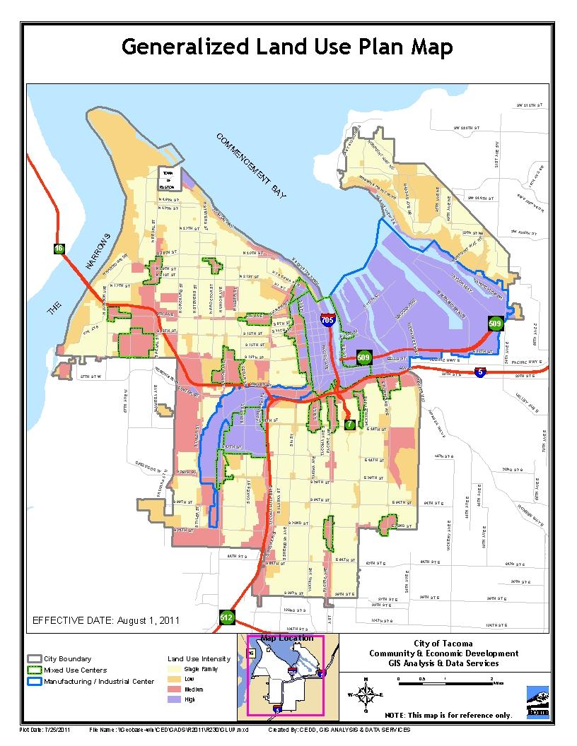
7
8
9 2013 Annual Amendment Application No Development Intensity Designations BACKGROUND BENCHMARKING January 10, 2013 Comprehensive Plan Land Use Designations Benchmarking The following chart provides some selected regional examples of Comprehensive Plan land use designations. As can be seen here, the approach and framework varies significantly by jurisdiction, with some cities utilizing relatively simple schemes with few designations and some cities using very detailed and complex systems with many, very detailed designations. City Tacoma Bellevue Comprehensive Plan Land Use Designations High Intensity (outside of mixed use centers) Medium Intensity(outside of mixed use centers) Low Intensity Single Family Detached Housing Area Downtown Mixed-Use Center Urban Mixed-Use Center Community Mixed-Use Center Neighborhood Mixed-Use Center Manufacturing/ Industrial Center Single Family Low Density-1.8 acres Medium Density-3.5 acres High Density- 5 acres Urban Res.-7.5 acres Multi Family Low- up to 10 per acre Med.-up to 20 High up to 30 Retail Neighborhood Business Community Business General Business General/ Community business Office Professional Office Office Office, Limited Business Office, Limited Business- Open Space Industrial Light Industrial Medical Institution Medical Institution
10 City Seattle Renton Spokane Redmond Comprehensive Plan Land Use Designations Urban Center Hub/ Residential Urban Village Manufacturing/ Industrial Center City- Owned Open Space Single Family Residential Areas Multi-Family Residential Areas Commercial / Mixed Use Areas Downtown Areas Industrial Areas Master Planned Communities Major Institutions Residential Designations Residential Low Density Residential Medium Density Residential Single Family Residential Multifamily Commercial Designations Commercial Corridor Commercial Neighborhood Commercial -Office Residential Center Designations Center Village Urban Center Downtown Urban Center North Employment Designations Employment Area Valley Employment Area Industrial Residential Designations Residential Low Density Residential Medium Density Residential Single Family Residential Multifamily Commercial Designations Commercial Corridor Commercial Neighborhood Commercial -Office Residential Center Designations Center Village Urban Center Downtown Urban Center North Employment Designations Employment Area Valley Employment Area Industrial Single Family Constrained Single Family Urban Multi-Family Urban Neighborhood Commercial General Commercial Downtown Mixed Use Business Park Manufacturing Park Design District Urban Recreation Semi-Rural Park and Open Space Agricultural(Outside of UGA) Rural (Outside of UGA)
11 City Yakima Comprehensive Plan Land Use Designations Current Single Family Detached Single Family Attached (2-4 units) Multi Family Mobile home Manufacturing Industries Transportation, Communication, Utilities Wholesale Retail Trade/Service Offices Public/ Semi Public Parks& Recreation Agriculture, Forest Vacant Underdeveloped Olympia Federal Way Future Low Density Residential Medium Density Residential High Density Residential Professional Office Neighborhood Commercial Large Convenience Center Arterial Commercial CBD Core Commercial Regional Commercial Industrial Low-Density Housing Medium-Density Housing Mixed Residential Neighborhood Centers Residential Mixed Use Planned Developments Professional Offices & Multifamily Housing Urban Waterfront Urban Corridors Central Business District General Commerce Auto Services Medical Services Industry City Center Core City Center Frame Community Business Commercial Enterprise Commercial/Recreation Corporate Park Multi-Family Neighborhood Commercial Office Park Parks and Open Space Professional Office Single Family, Low Density Single Family, Medium Density Single Family, High Density
12 City Edmonds Puyallup Comprehensive Plan Land Use Designations Retail Core Arts Center Corridor Downtown Mixed Commercial Downtown Convenience Downtown Mixed Residential Downtown Master Plan Shoreline Commercial Downtown Residence-Office Single Family- Urban 1 Single Family- Urban 2 Single Family- Urban 3 Single Family Resource Single Family Master Plan Multi Family- Medium Density Multi Family- High Density Neighborhood Commercial Community Commercial Planned Business/ Neighborhood Business Mixed Use Commercial Highway 99 Corridor Edmonds Way Corridor Hospital/ Medical Master Plan Development Public Park/ Open Space POC - Pedestrian Oriented Commercial AOC - Auto Oriented Commercial LC - Limited Commercial MUC - Mixed Use Commercial LM/W - Light Manufacturing/Warehousing B/IP - Business/Industrial Parks MDR - Moderate Density Residential HDR - High Density Residential WHNP - West Hills Neighborhood Plan LDR - Low Density Residential RBR - Rural Buffer Residential PF - Public Facilities MED - Medical Facilities FAIR - Fair OS/PP - Open Space/Public Parks
13 City Everett Comprehensive Plan Land Use Designations Residential Single Family Detached, 3-5 Dwellings per gross acre Single Family Detached, 5-10 Dwellings per gross acre Single Family Detached, Dwellings per gross acre Single Family Detached, Dwellings per gross acre Multiple Family, Dwellings per gross acre Multiple Family, Dwellings per gross acre Multiple Family, Dwellings per gross acre Multiple Family, 50+ Dwellings per gross acre Institutional Parks/Public Open Space Schools/Churches Colleges/Universities Cemeteries Hospitals Clinics, Medical and Professional Offices, Multiple Family Professional Office, Multiple Family Clinic, Medical Related Uses, Multiple Family Public/Quasi-Public Facilities Metropolitan Center Central Business District Commercial Neighborhood Business Community Business Office Mixed Use Commercial - Multiple Family Waterfront Commercial Industrial Heavy Industrial Maritime Service Light Industrial Office and Industrial Park Light Industrial Everett Station Agricultural Agriculture Aquatic Watershed Resource Management
14
15 2013 Annual Amendment Application No Development Intensity Designations PROPOSED FRAMEWORK January 10, 2013 Existing Designations and Zoning Framework The present version of Tacoma s Comprehensive plan is broken into four classifications, although it also incorporates other classifications such as Mixed Use Centers and Manufacturing/Industrial Centers in a confusing, overlapping system of classifications. This can be tricky when determining appropriate zoning within a land use area. Determining if a use fits within an area s vision can also be a time consuming and costly process for developers and the community. The following chart from the Growth and Development Strategy Element lays out the existing Plan designations and the associated zoning classifications. Comprehensive Plan Designations Typical Zoning Classifications High Intensity(outside mixed use centers) R 5 Medium Intensity (outside mixed use centers) HM R 4L R 4 C 2 PDB M 1 M 2 Low Intensity R 3 R 4L HMR SRD T C 1 Single Family Detached Housing Area R 1 R 2 R 2SRD Downtown Mixed Use Center Urban Mixed Use Center Community Mixed Use Center DR DMU WR DCC UCX TD UCX RCX URX CCX RCX HMX URX
16 Comprehensive Plan Designations Neighborhood Mixed Use Center Manufacturing/ Industrial Center Typical Zoning Classifications NCX RCX CIX HMX URX NRX PMI M 2 M 1 Proposed New Framework for the Comprehensive Plan s Land Use Designations The intent for this project is to revise and update the Plan s land use designation approach, from the current Land Use Intensities to a more simplified and easily understood classification system. The chart below outlines the proposed designations and the existing zoning classifications that would fit within each designation. Following the chart are general descriptions of each of the designations. Comprehensive Plan Land Use Corresponding Zoning Designations (proposed) Single Family Residential R 1 R 2 R 2SRD Multi Family R 3, R 4L HMR SRD T R 4 R 5 Commercial C 1 C 2 PDB HM (see bullet 2 below)presently park/open space or Open Space* greenways done by site specific permitting Industrial M 1 M 2 PMI Refer to SMP Shoreline * Downtown Mixed Use Center DR DMU WR DCC UCX TD
17 Comprehensive Plan Land Use Designations (proposed) Urban Mixed Use Center Community Mixed Use Center Neighborhood Mixed Use Center Corresponding Zoning UCX RCX URX CCX RCX HMX URX NCX RCX CIX HMX URX NRX General Land Use Concept for Each Proposed Designation Single Family Residential Single family detached housing is the preferred housing structure type for many of Tacoma's citizens. Qualities associated with single family neighborhoods that are generally viewed as desirable include: low noise levels, limited traffic, compatible building styles and uses, and low density development. Much of the city's land is strongly committed to single family development and has been determined to be deserving of special protection from incompatible land uses. Multi Family Other types of housing such as duplexes, triplexes, apartments, townhomes and condominiums are also needed and desired by large segments of the population. Housing choices are influenced by income, family size, age, lifestyles, and other factors which can change during a person's lifetime. Consequently, A wide variety of housing types are needed within a community to serve the varied needs of residents Commercial Pressure can be expected for additional retail and service uses to support the growing population. It is anticipated that this demand can be accommodated through redevelopment and intensification of uses within established commercial areas Commercial development involves a wide variety of uses and can range in scale from small neighborhood convenience shops to regional shopping centers. Commercial areas are the activity centers of the community. Commercial areas should be safe, well designed, appropriately scaled, and integrated into the fabric of the community. Commercial establishments must be properly located and easily accessible for the convenience of their customers. Commercial developments should be located within mixed use centers, in concentrations within areas of similar character, or in nodes at intersections of major traffic corridors. Such locations should lessen traffic congestion, increase consumer convenience, reduce utility and service installation and maintenance costs and encourage joint use of parking facilities. Infill development and intensification of existing commercial areas will aid their continued economic viability. In some limited instances, physical expansion of existing areas may be permitted; however, linear expansion is to be strictly limited.
18 Public Open Space The Public Open Space designation will operate as a means by which to identify and conserve wildlife and manage natural resources within the urban environment. Being a highly urbanized area Tacoma can benefit from putting additional standards on some of its remaining natural areas like steep slopes, wetlands and streams, and upland habitat areas as described in the Open Spaces and Recreation Element of the Comp Plan (Shoreline will be addressed separately because of its many distinct uses).this designation should be less of a limit on types of development but on how one develops and would focus on publicly owned open space and habitat properties instead of privately owned, undeveloped properties. In some cases, if this designation is applied to private properties, property owners could either build to the present zoning limits following green practices or opt for less development as an alternative. Requirements could include clustering, a technique used to preserve larger areas of natural habitat and allow for greenways. Industrial: Manufacturing/industrial centers are concentrations of manufacturing, industrial and related uses and are major employment areas. These areas need good access to local and regional transportation systems. Industrial facilities vary in size and function. Heavy industrial uses usually consist of larger scale buildings with adjacent large storage areas. These uses generally are associated with high nuisance levels. Light industrial development consists of smaller scale, non manufacturing and manufacturing uses. Generally, light industries are located on smaller sites and have lower nuisance levels. The function and the location of industrial establishments are highly related to convenient access to major transportation facilities and other manufacturers, as well as suppliers and distributors in the urban area. Potential adverse influences associated with industrial developments include noise, glare, vibration, air and water pollution, traffic congestion and safety hazards. Generally, heavy industrial developments are considered incompatible with other land uses because of their high nuisance level. However, some newer, technical types of industry produce few adverse effects. "Clean" industrial uses may be located in centers and near residential areas, provided that compatibility is maintained and proper controls are applied to limit any adverse influences on surrounding areas. Shoreline Designation: A single shoreline designation could be used to recognize the unique nature of the shoreline environment and the fact that it contains its owns set of guiding policy documents. In addition, the Shoreline Master Program already contains its own set of environment designations, which serve much the same role as generalized land use designations except with a greater focus on shoreline issues, making it unnecessary to provide both shoreline designations and separate generalized land use designations. A single designation would allow for quick reference to the general land use intent and guidance and a quick refer to the SMP for greater details as to what types of shoreline uses are allowed in individual portions of the shoreline. Mixed use Centers: Mixed use centers are compact, self sufficient areas, identifiable as the focus of the surrounding area. The mixed use center is a dense, well integrated variety of development types, combined in such a way that it is pedestrian oriented and transit supportive.
19 Downtown Mixed Use Center: The downtown center is the highest concentration of urban growth found anywhere in the city. It is the focal point for the city, the center of government, cultural, office, financial, transportation and other activities. This variety of day and night activities attracts visitors from throughout the city and region. The interstate freeway, major arterials, provides access and the center has both local and regional transit connections. Larger, often historic, buildings fronting on the sidewalk characterize the area. Pedestrian orientation is high. Parking is found along the street and within structures. Urban Mixed Use Center: The urban center is a highly dense concentration of urban development. Buildings can range from one to twelve stories and activity is greater than in most areas of the city. It is an area of regional attraction and a focus for both the local and regional transit systems. Many major city arterials connect to the urban center and nearby freeway access is present. Parking is provided both in surface lots and within structures. Internal streets and pathways provide connections among the developments within the center. Community Mixed Use Center: The community center is a concentration of commercial and/or institutional development that serves many nearby neighborhoods and generally includes a unique attraction that draws people from throughout the city. Some residential development may already be present, and there is a goal to have more residential development. It is directly accessible by arterials and local transit. Pedestrian accessibility is important within the center, but because of its focus on larger scale commercial development, the community center continues to provide for automobile parking, preferably within structures. Neighborhood Mixed Use Center: The neighborhood center is a concentrated mix of small to medium scale development that serves the daily needs of center residents, the immediate neighborhood, and areas beyond. Development contains a mix of residential and commercial uses, and the majority of parking is provided within structures. Buildings are generally up to six stories along the commercial corridors, up to three stories at the periphery of the centers near single family districts, and up to four stories in areas between the core and the periphery. They are designed with a compatible character to adjacent residential neighborhoods. The design of the neighborhood center encourages pedestrians and bicyclists and its location on a major arterial makes it a convenient and frequent stop for local transit. The regional transit network also may directly serve some neighborhood centers.
City of Tacoma Planning and Development Services
 Agenda Item D-3 City of Tacoma Planning and Development Services To: Planning Commission From: Stephen Atkinson, Associate Planner, Planning Services Division Subject: Land Use Designations - Phase 2 Meeting
CITY OF PUYALLUP. Background. Development Services
 CITY OF PUYALLUP Development Services 333 South Meridian Puyallup WA 98371 To: City Council From: Katie Baker, AICP, Planning Division Re: South Hill Neighborhood Plan Adoption Date: (Meeting date: February
Ridgefield and the Growth Management Act
 1 2 Ridgefield and the Growth Management Act 3 Why Do We Plan History of Planning in Ridgefield Washington experiences rapid growth in the late 1980 s that began to change the perceived quality of life.
LAND USE ELEMENT. Purpose. General Goals & Policies
 LAND USE ELEMENT Purpose This Land Use Element contains the goals and policies necessary to support the City s responsibility for managing land resources and guiding development through implementing regulations,
Rural Land Use Designations Kittitas County December 6, 2007 Draft
 KITTITAS COUNTY COMMUNITY DEVELOPMENT SERVICES 411 N. Ruby St., Suite 2, Ellensburg, WA 98926 CDS@CO.KITTITAS.WA.US Office (509) 962-7506 Fax (509) 962-7682 Rural Land Use Designations Kittitas County
POLICIES & REGULATIONS
 POLICIES & REGULATIONS Land use planning is now heavily regulated in certain counties of Washington State because of past rapid growth. The most significant change brought about by the Washington State
Dwelling Units Max 12 dwelling units per acre/min 8 dwelling units per acre. Development Mix 80% non residential/20% residential
 13. OSTEEN LOCAL PLAN Background: The Osteen Local Plan area is located in southwest Volusia County along the SR 415 corridor between Lemon Bluff Road and Acorn Lake Road and includes 3,990 acres. The
Urban Fringe Subarea Plan
 Urban Fringe Subarea Plan Updated February 27, 2018 Table of Contents Page I. Existing Goals and Policy Framework 2 A. Growth Management Act (GMA) B. County-wide Planning Policies C. Whatcom County Comprehensive
Gold Line Bus Rapid Transit Transit Oriented Development (BRTOD) Helmo Station Area Plan
 Helmo Station Area Plan") Appendix F Gold Line Bus Rapid Transit Transit Oriented Development (BRTOD) Helmo Station Area Plan Introduction and Purpose of the Plan The Gold Line Bus Rapid Transit facility is an eleven-mile dedicated
Appendix F Gold Line Bus Rapid Transit Transit Oriented Development (BRTOD) Helmo Station Area Plan Introduction and Purpose of the Plan The Gold Line Bus Rapid Transit facility is an eleven-mile dedicated
PSRC REVIEW REPORT & CERTIFICATION RECOMMENDATION
 PSRC REVIEW REPORT & CERTIFICATION RECOMMENDATION KITSAP COUNTY COUNTYWIDE PLANNING POLICIES July 2, 2012 BACKGROUND A major emphasis of the Washington State Growth Management Act (GMA) is the need to
To ensure that resources will be available to provide a consistent level of public services to the community.
 Future Land Use Plan The land use plan is one of the most prominent chapters in the Stillwater Comprehensive Plan. It provides a visual representation of what the community is expected to look like in
CONTENTS 8.0 LAND USE 8.1 GENERAL LAND USE 8.2 RESIDENTIAL 8.3 MIXED USE 8.4 COMMERCIAL 8.5 EMPLOYMENT LANDS
 8-2 Land Use 8.0 LAND USE CONTENTS 8.1 GENERAL LAND USE 8.1.1 Uses provided for in all Land Use Designations 8.1.2 Uses prohibited in Hazardous Lands, Hazardous Sites and Special Policy Areas 8.1.3 Uses
LAND USE OVERVIEW WHAT YOU WILL FIND IN THIS CHAPTER
 LAND USE WHAT YOU WILL FIND IN THIS CHAPTER Information about the City s expected population and employment growth. Description and capacity of existing and future land use designations. Policies that
6 PORT SYDNEY SETTLEMENT AREA
 Section 6 Port Sydney Page 61 6 PORT SYDNEY SETTLEMENT AREA 6.1 Basis and Principles Village of Port Sydney Waterfront Community Existing Services 6.1.1 Port Sydney is an historic settlement that has developed
4.1.3 LAND USE CATEGORIES
 4.1.3 LAND USE CATEGORIES a. City Center District The City Center District incorporates the existing character and mix of uses in downtown Belmont to encourage redevelopment and new development in keeping
Metro. Activity Center Design Guidelines. Recommendations For Developing Focused, Mixed-Use Commercial/Residential Centers
 Metro Activity Center Design Guidelines Recommendations For Developing Focused, Mixed-Use Commercial/Residential Centers Metro Activity Centers What is a MAC? Legacy, the adopted guide for the future growth
City of Tacoma Planning and Development Services
 Agenda Item D-1 City of Tacoma Planning and Development Services To: Planning Commission From: Elliott Barnett, Planning Services Division Subject: Application #2014-08 Open Space Element Update Meeting
AWH REPORT OF THE PLANNING AND DEVELOPMENT DEPARTMENT FOR APPLICATION FOR REZONING ORDINANCE TO PLANNED UNIT DEVELOPMENT
 AWH REPORT OF THE PLANNING AND DEVELOPMENT DEPARTMENT FOR APPLICATION FOR REZONING ORDINANCE TO PLANNED UNIT DEVELOPMENT MAY 8, 2014 The Planning and Development Department hereby forwards to the Planning
4. Shape Transitions. 4. Shape Transitions
 4. Shape Transitions 49 Zoning District Policies Overall Intent: Maintain neighborhood character by creating compatible transitions that minimize land use conflicts. Strategy: Define the character of zoning
and services The protection and conservation of environmentally significant and sensitive natural heritage features and functions.
 6. Land Use 6.0 Preamble A healthy and livable city is one in which people can enjoy a vibrant economy and a sustainable healthy environment in safe, caring and diverse neighbourhoods. In order to ensure
Chapter 1 - General Design Guidelines CHAPTER 1 GENERAL DESIGN GUIDELINES
 CHAPTER 1 GENERAL DESIGN GUIDELINES 1.0 INTRODUCTION This Publication has been developed to provide current, uniform procedures and guidelines for the application and design of safe, convenient, efficient
NEW CASTLE COUNTY S ZONING DISTRICTS
 NEW CASTLE COUNTY S ZONING DISTRICTS This is general information about New Castle County s zoning districts. The information included is by no means exhaustive or complete. Before designing plans to develop
IMPLEMENTATION STRATEGIES. In This Chapter. Goals & Strategies 182 Project List 183 Future Land Use 186 CHAPTER 11 IMPLEMENTATION STRATEGIES
 In This Chapter Goals & Strategies 182 Project List 183 Future Land Use 186 11 IMPLEMENTATION STRATEGIES NORTH AUGUSTA, SC 2017 COMPREHENSIVE PLAN 179 Individual commitment to a group effort that is what
LAND USE MEADOWS PLANNING AREA
 LAND USE MEADOWS PLANNING AREA I. Profile of Meadows Planning Area A. Location Meadows Planning Area is delineated by I-5 on the north, the Nisqually Bluffs representing the growth boundary on the east,
LAND USE DESIGNATIONS AND ZONING CLASSIFICATIONS
 LAND USE DESIGNATIONS AND ZONING CLASSIFICATIONS One of the most significant issues addressed within the community plan process is land use. How land is utilized within a community directly affects the
LAND USE CATEGORIES. City of Sparks Comprehensive Plan Chapter Two: Pathway to the Future - Draft 1
 LAND USE CATEGORIES The following tables summarize the land use categories identified on the Map, describing the s designation shown on the Map. The tables summarize the primary uses and other uses, residential
CHAPTER 7: VISION AND ACTION STATEMENTS. Noble 2025 Vision Statement
 CHAPTER 7: VISION AND ACTION STATEMENTS This chapter presents the vision, policy and action statements that transform the comprehensive planning study, an analysis of Noble s past, future trends and community
Improve Neighborhood Design and Reduce Non Point Source Water Pollution
 HOW TO Planning Guide Improve Neighborhood Design and Reduce Non Point Source Water Pollution This document was funded by a grant from the New Hampshire Coastal Program with funding from the National Oceanic
LAND USE TANGLEWILDE/THOMPSON PLACE PLANNING AREA. C. Identified Neighborhood Groups and Homeowner s Associations
 LAND USE TANGLEWILDE/THOMPSON PLACE PLANNING AREA I. Profile of Tanglewilde/Thompson Place Planning Area (Revised 3/5/02) A. Location The Tanglewilde/Thompson Place Planning Area is located just east of
GENERAL LAND USE PLAN ELEMENT
 CITY OF Prepared by City of Medford Planning Department 200 South Ivy Street Medford, Oregon 97501 plnmed@ci.medford.or.us James E. Huber, AICP, Planning Director COMPREHENSIVE PLANNING SECTION John Adam,
ATTACHMENT A. Definition of Activity Centers
 ATTACHMENT A Definition of Activity Centers Lynnwood Link Extension DEFINITION OF ACTIVITY CENTERS FTA definition: When performing an assessment of Land Use and Economic Development Effects, the FTA New
SECTION II SECTION II STATEMENT OF GOALS, OBJECTIVES, PRINCIPLES, ASSUMPTIONS, POLICIES AND STANDARDS
 STATEMENT OF GOALS, OBJECTIVES, PRINCIPLES, ASSUMPTIONS, POLICIES AND STANDARDS 1 2 STATEMENT OF GOALS, OBJECTIVES, PRINCIPLES, ASSUMPTIONS, POLICIES AND STANDARDS INTRODUCTION The New Jersey Municipal
A Growing Community Rural Settlement Areas
 Town of Huntsville Official Plan Review - POLICY BACKGROUND PAPER A Growing Community Rural Settlement Areas BACKGROUND: In addition to the fully municipally-serviced Urban Settlement Area and the Hidden
FUTURE LAND USE ELEMENT
 FUTURE LAND USE ELEMENT GOAL I: To create and sustain a great place to live, play, and prosper Objective 1: The City of Ocala shall incorporate the principles and strategies of the Ocala 2035 Vision into
LAND USE CATEGORIES. City of Sparks Comprehensive Plan Land Use Categories - Draft
 LAND USE CATEGORIES The following tables summarize the land use categories identified on the Map, describing the s designation shown on the Map. The tables summarize the primary uses and other uses, residential
PORT WHITBY COMMUNITY
 PORT WHITBY COMMUNITY SECONDARY PLAN UPDATE COMMUNITY IMPROVEMENT PLAN URBAN DESIGN GUIDELINES September 2015 DRAFT PROPOSED AMENDMENT NUMBER # to the Whitby Official Plan PURPOSE: The intent of this Amendment
EXISTING COMPREHENSIVE PLAN
 EXISTING COMPREHENSIVE PLAN Town Center Land Use Element: V. LAND USE POLICIES Town Center Mercer Island's business district vision as described in "Your Mercer Island Citizen-Designed Downtown" was an
Planning Commission Retreat March 23 rd Comprehensive Plan Update Discussion
 Planning Commission Retreat March 23 rd 2011 Comprehensive Plan Update Discussion Purpose of This Discussion Go Over Key Aspects of the Update Discuss Element By Element Key Concepts Big Ideas What Policies
Chapter 10 IMPLEMENTATION RECOMMENDATIONS
 Chapter 10 IMPLEMENTATION RECOMMENDATIONS The recommended land use plan presented in the previous chapter provides a design for the attainment of the urban and rural development and open space preservation
Chapter 4: Land Use Plan
 Chapter 4: Plan 4.1. GENERAL DEVELOPMENT POLICIES Chapter Purpose The Plan is the foundation of the City s Comprehensive Plan. The plan identifies where people will live, work, shop and play. Development
Chapter 2: Land Use Element
 Chapter 2: Land Use Element CHAPTER 2: LAND USE ELEMENT A VISION FOR LAND USE As Lake Stevens continues to grow in population and area, the city will strive to create balanced opportunities for residential
General Location Annex, Rezone & Preliminary Plat Lansdowne Addition, Unit Three
 NEWFOUNDLAND I-5 Agricultural District Subject Site SUNDANCE ANDERSON Single Family Residential CHRISTY PUD Agricultural District Highway Business General Location Annex, Rezone & Preliminary Plat Lansdowne
The following rules shall be used to determine the precise location of any zone boundary shown on the Official Zoning Map of Auburn:
 ARTICLE III. ESTABLISHMENT OF ZONING DISTRICTS Section 300. Establishment of Zoning Districts. The City of Auburn, Alabama is hereby divided into zoning districts of such number and character as are necessary
City of Richland Comprehensive Plan: Integrated Non-project Final Environmental Impact Statement
 City of Richland Comprehensive Plan: Integrated Non-project Final Environmental Impact Statement September 12, 2017 Prepared for: City of Richland Prepared by: Oneza & Associates With assistance from:
2018 AMENDMENT TO THE COMPREHENSIVE PLAN
 2018 AMENDMENT TO THE COMPREHENSIVE PLAN AND LAND USE REGULATORY CODE Summary of Proposed Amendments A Plan or Code Amendment is the process through which the City considers changes, additions, and updates
Planned Development Review Revisions (Project No. PLNPCM )
") Planned Development Review Revisions (Project No. PLNPCM2014-00139) Standard residential development Planned Development Example: Smaller lot sizes than what is allowed to create open space amenity. What
Planned Development Review Revisions (Project No. PLNPCM2014-00139) Standard residential development Planned Development Example: Smaller lot sizes than what is allowed to create open space amenity. What
ALBEMARLE COUNTY CODE CHAPTER 18 ZONING SECTION 20A NEIGHBORHOOD MODEL - NMD
 CHAPTER 18 ZONING SECTION 20A NEIGHBORHOOD MODEL - NMD Sections: 20A.1 PURPOSE AND INTENT 20A.2 STATUS AS A PLANNED DEVELOPMENT DISTRICT 20A.5 CODES OF DEVELOPMENT 20A.6 PERMITTED USES 20A.7 RESIDENTIAL
Westbound: A One-day Exploration of Growth
 Westbound: A One-day Exploration of Growth Frog Pond Area 2018 UGB Expansion Proposal June 13, 2018 Growing Out: UGB Asks Four cities submitted proposals to expand greater Portland s urban footprint by
2040 LUP is a part of the Comprehensive Plan and carries the same legal authority. Economic Challenges
 1.1. Guiding Anchorage s Growth Where will new residents settle over the next two decades? Where will people work, shop, and play? Will there be enough room to grow? How will Anchorage look? Will growth
RESIDENTIAL DISTRICTS
 RESIDENTIAL DISTRICTS The residential district standards have been revised to reflect on-the-ground conditions, while continuing to respect the use patterns established within the neighborhoods. This will
Applicant Name Phone / Fax / Address City State Zip Code . Property Owner Phone / Fax / Address City State Zip Code
 Master Development Plan Application Community Development Department City of Redmond 411 SW 9 th Street Redmond, Oregon 97756 541-923-7721 541-548-0706 FAX Master Development Plan Fee $38,862.52 File Number
Woodburn Comprehensive Plan Growth Management Goals and Policies
 Goal Woodburn Comprehensive Plan Growth Management Goals and Policies G-1. The City's goal is to manage growth in a balanced, orderly and efficient manner, consistent with the City s coordinated population
4.1 LAND USE AND PLANNING EXISTING CONDITIONS REGULATORY BACKGROUND LAND USES IN THE PLAN AREA SURROUNDING LAND USES
 4.1 LAND USE AND PLANNING This section includes a description of the existing land use plans that apply to the Plan area and a description of existing land uses in the vicinity. It also includes an analysis
CENTERS CORRIDORS WEDGES GLOSSARY
 Affordable Housing: Generally defined as housing for which the occupant is paying no more than 30 percent of their gross income for housing costs, including utilities. The City of Charlotte defines affordable
A. Selma Park, Davis Bay and Wilson Creek
 A. Selma Park, Davis Bay and Wilson Creek This waterfront neighbourhood consists of three separate community areas, linked by Highway 101, but with different character, land use patterns and future potential.
Rapid City Planning Commission Comprehensive Plan Amendment Project Report
 Rapid City Planning Commission Comprehensive Plan Amendment Project Report June 7, 2018 Applicant Request(s) Item #3 Case # 18CA001 Comprehensive Plan Amendment to change the future land use from Mixed-
3.10 LAND USE SETTING PROJECT SITE EXISTING LAND USE DESIGNATIONS AND ZONING. General Plan Land Use Designations.
 This section of the Draft EIR addresses the existing land uses on and adjacent to the project site and discusses the potential impacts of the proposed project on existing land uses. Key issues addressed
CHARLES PUTMAN CHARLES PUTMAN AND ASSOCIATES, INC
 MEMORANDUM CHARLES PUTMAN & ASSOCIATES, INC. LAND DEVELOPMENT CONSULTANTS PLANNING ZONING PERMITTING 4722 NW Boca Raton Boulevard, Suite C-106 Boca Raton, Florida 33431 Phone: 561/994-6411 FAX: 561/994-0447
DISCUSSION TOPIC: ST JOHNS RIVER & ITS TRIBUTARIES (BPII) 2030 COMPREHENSIVE PLAN POLICES AND REGULATORY FRAMEWORK
 2030 COMPREHENSIVE PLAN POLICES AND REGULATORY FRAMEWORK") DISCUSSION TOPIC: ST JOHNS RIVER & ITS TRIBUTARIES (BPII) 2030 COMPREHENSIVE PLAN POLICES AND REGULATORY FRAMEWORK St. John s River & Its Tributaries Issue Summary: The St. Johns River is an important
DISCUSSION TOPIC: ST JOHNS RIVER & ITS TRIBUTARIES (BPII) 2030 COMPREHENSIVE PLAN POLICES AND REGULATORY FRAMEWORK St. John s River & Its Tributaries Issue Summary: The St. Johns River is an important
CHAPTER 4 FUTURE LAND USE AND URBAN SERVICES DISTRICTS
 CHAPTER 4 FUTURE LAND USE AND URBAN SERVICES DISTRICTS Introduction This chapter discusses how Benzie County should grow and change in the future. A community can grow and change in many different ways.
178 Carruthers Properties Inc.
 178 Carruthers Properties Inc. Planning Rationale for 178 Carruthers Avenue Site Plan Control Application June 2014 Table of Contents 1.0 Introduction 2.0 Overview of Subject Property 3.0 Current Zoning
City Of Sparks Planning Commission Item
 Page 1 of 12 City Of Sparks Planning Commission Item Meeting Date: May17, 2012 Subject: PCN12009, Public Hearing, Consideration and possible action on a Master Plan Amendment and Rezoning request to change
Location. Need GOAL 14 URBAN GROWTH BOUNDARY. Urban Planning in Oregon 7/8/2015
 Urban Planning in Oregon June 24, 2015 Redmond, Oregon Gordon Howard, DLCD Urban Planning Specialist GOAL 14 URBAN GROWTH BOUNDARY To provide for an orderly and efficient transition from rural to urban
Concord Community Reuse Project Goals and Guiding Principles. Overarching Goals (OG)
") Concord Community Reuse Project Goals and Guiding Principles Overarching Goals (OG) No priority is implied by the order of presentation of the goals and guiding principles. Overarching goals for the Concord
Concord Community Reuse Project Goals and Guiding Principles Overarching Goals (OG) No priority is implied by the order of presentation of the goals and guiding principles. Overarching goals for the Concord
SOUTH NATOMAS COMMUNITY PLAN
 SOUTH NATOMAS Community Plan Part Three : COMMUNITY PLAN AREAS AND SPECIAL STUDY AREAS SACRAMENTO 2030 GENERAL PLAN Contents Community Location... 3-SN-3 Community Vision... 3-SN-4 Community Profile...
6. REGIONAL AND COMMUNITY FACILITIES DESIGNATIONS 6.1. OBJECTIVES FOR REGIONAL AND COMMUNITY FACILITIES LAND USE DESIGNATIONS
 6. REGIONAL AND COMMUNITY FACILITIES DESIGNATIONS INTRODUCTION The Regional and land use designations provide the primary locations for uses which satisfy the health, education and other service needs
The transportation system in a community is an
 7 TRANSPORTATION The transportation system in a community is an important factor contributing to the quality of life of the residents. Without a sound transportation system to bring both goods and patrons
COMMISSION ACTION FORM
 ITEM #: 6 DATE: 09-06-17 COMMISSION ACTION FORM REQUEST: Introduction and Initial Review of Proposed Amendments to the Ames Urban Fringe Future Land Map for the North Growth Gap Area BACKGROUND INFORMATION:
EXECUTIVE SUMMARY DRAFT CHAPTER 1 INTRODUCTION EXECUTIVE SUMMARY
 CHAPTER 1 EXECUTIVE SUMMARY INTRODUCTION Through the joint efforts of the City of Tulsa planning staff and the Land Services division of Indian Nations Council of Governments (INCOG), the Berryhill Land
ARTICLE 6: Special and Planned Development Districts
 ARTICLE 6: Special and Planned Development Districts 6-10 Traditional Neighborhood Development (TND) District 6-10.10 Purpose and Intent The Traditional Neighborhood Development (TND) District provides
Official Plan Review
 Official Plan Review Summary Report - The Built Environment August 2014 Part 1: Introduction Planning for a healthy, prosperous and sustainable community is an important goal for our municipality. From
AREASTRUCTURE PLAN AMENDMENT COCHRANE NORTH
 AREASTRUCTURE PLAN AMENDMENT COCHRANE NORTH In order to implement the vision outlined in the Conceptual Scheme, the following three amendments to the Cochrane North ASP are proposed: 1. Allow commercial
FUTURE DEVELOPMENT AREAS
 FUTURE DEVELOPMENT AREAS Refer to the Future Development Map on Page 2. Suburban Residential (Less than 3 units/acre) Suburban Residential neighborhoods form the backbone of Smyrna. While growth and redevelopment
Warren County/Bowling Green Focus 2030 Comprehensive Plan VOLUME 1 INDEX
 Appendix 5: Index VOLUME 1 INDEX A Aesthetics ES-6, FLU-15, FLU-17, FLU-24, NCR-7 Agricultural Base FLU-18, FLU-20 Agricultural Centers, Rural FLU-11 Agricultural District NCR-17-NCR-18 Agricultural Economy
Town of Liberty, NY COMPREHENSIVE PLAN & ZONING UPDATES
 Town of Liberty, NY S Public Informational Meeting October 4, 2016 High School Auditorium Welcome Thank you for coming tonight. Agenda Part I Overview of Proposed Changes What is Being Prepared Anticipated
City of Tacoma Planning and Development Services
 Agenda Item E-1 City of Tacoma Planning and Development Services To: Planning Commission From: Elliott Barnett, Planning Services Division Subject: Tacoma Mall Regional Center Subarea Plan and EIS Meeting
PLANNING ADVISORY BOARD AGENDA OCTOBER
 ! City of Langley PLANNING ADVISORY BOARD AGENDA OCTOBER 1, 2014 3-5pm LANGLEY CITY HALL - 112 2 nd Street, Langley WA 1) Call to Order and Roll Call 2) Approval of the Minutes September 10, 2014 3) Public
13 THORNHILL YONGE STREET STUDY IMPLEMENTATION CITY OF VAUGHAN OPA 669 AND TOWN OF MARKHAM OPA 154
 13 THORNHILL YONGE STREET STUDY IMPLEMENTATION CITY OF VAUGHAN OPA 669 AND TOWN OF MARKHAM OPA 154 The Planning and Economic Development Committee recommends the adoption of the recommendations contained
Transportation. Strategies for Action
 Transportation A major priority for the Overlake Neighborhood is to develop a multimodal transportation system. To achieve this system, a balance has to be found among travel, circulation and access needs;
TREASURE COAST REGIONAL PLANNING COUNCIL M E M O R A N D U M. To: Council Members AGENDA ITEM 5H
 TREASURE COAST REGIONAL PLANNING COUNCIL M E M O R A N D U M To: Council Members AGENDA ITEM 5H From: Date: Subject: Staff October 17, 2008 Council Meeting Local Government Comprehensive Plan Review Draft
Draft CHAPTER TWO THREE LAND USE PLAN
 CHAPTER TWO THREE LAND USE PLAN LAND USE PLAN The basic intent of the comprehensive planning process is to provide a well-founded and coordinated decision-making framework to guide both public and private
BROOKHILL NEIGHBORHOOD MODEL ZONING MAP AMENDMENT PREFACE TO APPLICATION
 BROOKHILL NEIGHBORHOOD MODEL ZONING MAP AMENDMENT PREFACE TO APPLICATION June 15, 2015 Revised: August 1, 2016 I. VISION Brookhill is a proposed community based upon the principles of Albemarle County
Overview of the Plan. The Building Blocks of Centers, Neighborhoods and Network INTERNAL DRAFT
 Overview of the Plan 4 East Davidson Ramah Church Rd June Washam Rd Bradford District Park Bradford Shearer Rd Campus District NC 73 Davidson-Concord North Rocky River This Master Plan projects an approximate
6.0 Land Use Policies for Rural Settlements. 6.1 Rural Settlement Strategy
 6.0 Land Use Policies for Rural Settlements 6.1 Rural Settlement Strategy INTRODUCTION AMENDMENT NO. 131 PURPOSE Designated rural settlements comprise Rural Clusters, Villages and Serviced Villages as
Staff Report to the North Ogden City Planning Commission
 Staff Report to the North Ogden City Planning Commission SYNOPSIS / APPLICATION INFORMATION Application Request: Concept review on a legislative application to rezone land located at approximately 1750
HAZARD MITIGATION GOALS AND OBJECTIVES
 SEWRPC Community Assistance Planning Report No. 282, 2nd Edition CITY OF MILWAUKEE ALL HAZARDS MITIGATION PLAN UPDATE Chapter IV HAZARD MITIGATION GOALS AND OBJECTIVES [NOTE: Throughout this plan update
Staff Report and Recommendation
 Community Planning and Development Planning Services 201 W. Colfax Ave., Dept. 205 Denver, CO 80202 p: 720.865.2915 f: 720.865.3052 www.denvergov.org/cpd TO: City Council Neighborhoods and Planning Committee
E. RURAL COMMERCIAL/INDUSTRIAL PARK MODEL
 E. RURAL COMMERCIAL/INDUSTRIAL PARK MODEL 1. PURPOSE The purpose of the Rural Commerce/Industrial Park Model is to provide parameters within which a grouping of business buildings with parking, loading
Guiding Principles, Objectives, Strategies and Policies
 Guiding Principles, Objectives, Strategies and Policies Section 1 Introduction These Guiding Principles were adopted as part of the 1999 Athens-Clarke County Comprehensive Plan and are carried over, in
4: THE FRAMEWORK PLAN
 4: THE FRAMEWORK PLAN The American Transect. Drawing by James Wassell FRamework Plan: Purpose and Philosophy The Framework Plan is a land use policy map intended to provide guidance to Boone s leaders
RECREATION AND OPEN SPACE ELEMENT GOALS, OBJECTIVES, AND POLICIES
 RECREATION AND OPEN SPACE ELEMENT GOALS, OBJECTIVES, AND POLICIES Goal 7 To provide park facilities, recreation programs, and open space resources that are safe, adequate, and accessible to all City residents,
CHAPTER 1. Ms. Guajardo s Class - Central Elementary CH 1 1
 INTRODUCTION CHAPTER 1 Ms. Guajardo s Class - Central Elementary CH 1 1 1.1 SETTING South Centre City is a linear corridor south of Downtown Escondido paralleling Centre City Parkway and South Escondido
Clackamas County Comprehensive Plan. Chapter 4: LAND USE
 Chapter 4: LAND USE When the pioneers settled Clackamas County, the land resource appeared infinite. They cleared forest, carved towns from the wilderness, and used waterways as the arterials of commerce.
Potential Annexation Areas And Annexation
 Exhibit A to Ordinance No. - Proposed Amendments to the Pierce County Countywide Planning Policies Addressing Potential Annexation Areas And Annexation 1 0 1 0 1 COUNTYWIDE PLANNING POLICY ON URBAN GROWTH
SECTION UNIFIED DEVELOPMENT ORDINANCE SECTION Part 1 Ordinance. ARTICLE 1 Zoning Districts
 SECTION 1-100 UNIFIED DEVELOPMENT ORDINANCE SECTION 1-300 Part 1 Ordinance SECTION 1-100. Introduction. ARTICLE 1 Zoning Districts Crystal Lake strives to maintain a balance of various land uses for a
VILLAGE OF CLEMMONS PLANNING BOARD DRAFT STAFF REPORT
 VILLAGE OF CLEMMONS PLANNING BOARD DRAFT STAFF REPORT PETITION INFORMATION Docket # C-226 Staff Megan Ledbetter Petitioner(s) JBJH Properties, LLC Owner(s) JBJH Properties, LLC Subject Property 5892-49-1766
Neighborhoods. C.8. Willows/Rose Hill Neighborhood Policies
 C.8. Willows/Rose Hill Neighborhood Policies The Willows/Rose Hill Neighborhood is located on the hillsides west of the Sammamish Valley in the northwest corner of Redmond. The neighborhood is bound on
Living in Albemarle County s Urban Places
 Living in Albemarle County s Urban Places ALBEMARLE COUNTY, VIRGINIA A Closer Look at Albemarle s Approach to Managing Growth and Creating Quality Urban Environments www.albemarle.org Page 2 Living in
This page intentionally blank.
 This page intentionally blank. Parks, Recreation, and Open Space Chapter Relationship to Vision Vision Parks, Recreation and Open Space Chapter Concepts County Government. County government that is accountable
CHAPTER 2: FUTURE LAND USE CONCEPTS
 CHAPTER 2: FUTURE LAND USE CONCEPTS INTRODUCTION The future land use concepts presented in this chapter are an expression of community support for a viable and vital US 50 Corridor. Land use recommendations