AUSTIN MEDICAL DISTRICT MASTER PLAN"
|
|
|
- Abraham Brooks
- 6 years ago
- Views:
Transcription
=@,+'=03$AB,+-(C)'$ DE,$!)=@,+'=03$C/$D,F-'$-0$%&'()$ $?-),H='0'P$.")
0$ G,0C)$<,)0&+,'$-)2$%HH=-)>,'$ $ G,0C)$I,-H0E>-+,$J-K=H3$ MC2,+-0C+P$")
$*+,-.")
1 AUSTIN MEDICAL DISTRICT MASTER PLAN"!"#$%&'"()(&$*+,--$ $?-),H='0'P$.(/$0&1"23$ $ G,)=C+$<=>,$?+,'=2,)0$ G,0C)$<,)0&+,'$-)2$%HH=-)>,'$ $ G,0C)$I,-H0E>-+,$J-K=H3$ MC2,+-0C+P$ *+&"62$<2(="()6$ GE-+,ECH2,+$ Q+-@,'$RC&SE,+03$I,-+C)$T$MCC23$ $ <:4.$4%:94:;$!"#$%&'()$*+,-./-'0$ 1,2),'2-3$4$5&),$678$69:;$ 0&""3$452)6$ DE,$1L$"L$MCC23$5+L$N,)0,))=-H$?+C/,''C+$=)$%+>E=0,>0&+,$ DE,$!)=@,+'=03$C/$D,F-'$-0$%&'()$ $ 7879.$4%:94:;4$ O$
2 CAMPUS MASTER PLAN Academic Affairs Committee May
3 ACCOMMODATING GROWTH 2

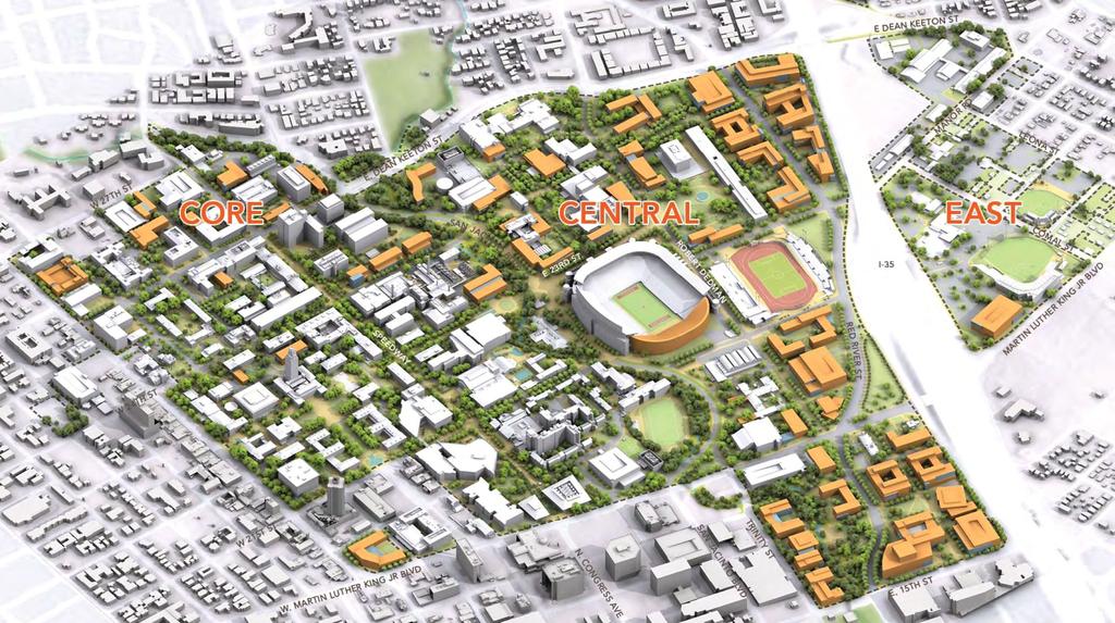
4 CAMPUS ZONES Core 196 acres Central 182 acres East 52 acres 3

5 FAR = Floor Area Ratio, a measure of building density 4
6 PROJECTING POTENTIAL GROWTH 7.2 million GSF over 30 years Increased density in the central campus could accommodate about 50% of potential growth 5

7 NET NEW DEVELOPMENT Zone Core Central East Total Net New 784,768 5,444, ,003 6,607,601 6
8 NET NEW DEVELOPMENT 7
9 REVITALIZING THE CORE AND ENHANCING THE CENTRAL CAMPUS 8


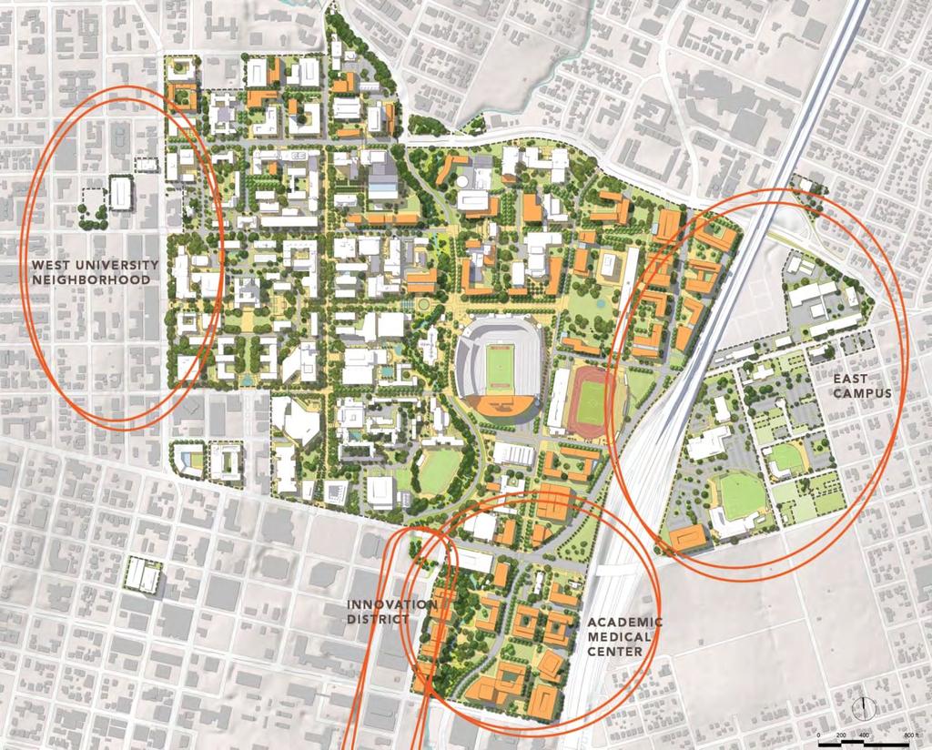
10 CAMPUS CORE 9


11 WEST 21ST STREET Existing Condition Removing parking and reducing driving lanes will create a better streetscape Proposed Street Section Design Parking removed Street trees with bioswale added for shade and stormwater management Cycle track added and sidewalk width increased Existing utilities remain under sidewalk and cycle track Proposed Street Section 10

12 CENTRAL CAMPUS 11

13 WALLER CREEK AND SAN JACINTO CORRIDOR 12

14 Designing an accessible edge to Waller Creek 13
15 MOBILITY 14
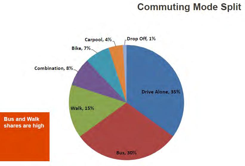
16 15


17 PEDESTRIAN MOVEMENT BICYCLE FRAMEWORK PARKING FRAMEWORK LIGHT RAIL FRAMEWORK 16


18 CENTRAL SAN JACINTO Existing Condition Auto & Bus traffic, Bicycles, potential Light Rail compete for mobility space; pedestrians marginalized No distinction between modes Removing parking would allow more space for other modes Proposed Street Section Design Parking removed General auto access restricted; bus / light rail access only Bike path added Street trees added Walkway widths increased Proposed Street Section 17
19 ATTRACTION AND RETENTION OF BEST FACULTY AND STUDENTS 18


20 INTEGRATING ACADEMIC AND RESIDENTIAL LIFE Student Population Density The highest concentration of students is in the West University Neighborhood 19
21 20


22 FUTURE FOCUS Academic Plan Coordination Landscape Master Plan and Design Guidelines East Campus Plan Student and Residential Life Plan Athletics Master Plan City Coordination 21
23 UT AUSTIN MEDICAL DISTRICT MASTER PLAN 22
24 EXISTING 23

25 PROPOSED 24
26 SITE ANALYSIS 25

27 EXISTING CAMPUS 26

28 AUSTIN

29 CAPITAL VIEW CORRIDORS Five capital view corridors impact the UT Medical District site, including: 13, 30, 23, 24, 25 28

30 FEMA COMPARISON FEMA floodplains: 100-year between 493' at 15th Street and 502' at Trinity Street and 500-year between 496' at 15th Street and 504' at Trinity Street - based on existing development conditions FEMA floodplain based on latest flood studies from City of Austin and are more extensive than published FEMA map (elevation has not changed, but extent now appears to be based on city 2003 topo data) City of Austin 25yr Floodplain New FEMA 100yr Floodplain New FEMA 500yr Floodplain 29

31 RED RIVER RE-ALIGNMENT -of- Way show no major challenges for vehicular or pedestrian access P COLLECTIONS DEPOSIT LIBRARY +532 HARGIS HALL NURSING ERWIN +524 FUTURE HOSPITAL COOLEY SOM


32 BUILDING REMOVAL TIMELINE Permanent Use 1. Historic buildings from the 19 th century: John R. Hargis Hall and Arno Nowotny Building 2. Trinity Garage th Street Parking Garage 4. Plant Operations Long Term Use 5. Nursing School 6. Clinical Education Center 7. CEC Parking Garage John R. Hargis Hall Arno Nowotny 1 Building Heman Sweatt Campus Middle Term Use 8. Erwin Center 9. Denton A. Cooley Pavilion 10. Collections Deposit Library 11. Cyberknife 9 8 Short Term Use 12. UMCB 13. Blackstock Family Health Center 14. Hospital Heliport Permanent Use Long Term Use (16+ years) Middle Term Use (6-15 years) Short Term Use (1-5 years) 31

33 POTENTIAL SITES 7 building sites for short-term and long-term use Total available developable site area is 47.6 acres Site Acreage of Available Sites Building Sites Potential Building Sites 32

34 MASTER PLAN 33
35 EXISTING 34
 HOSPITAL PARKING STRUCTURE P")
36 PHASE 1 Phase 1 GSF: 1,415,100 P RESEARCH NURSING Dell Medical School P URBAN RAIL STATION MOB (1) HOSPITAL PARKING STRUCTURE P 35

 PSYCH HOSPITAL CANCER")
37 PHASE 2 Phase 2 GSF: 603,000 P RESEARCH NURSING Dell Medical School P URBAN RAIL STATION MOB (1) PARKING STRUCTURE HOSPITAL P MOB (2) PSYCH HOSPITAL CANCER CENTER 36

 PARKING STRUCTURE")
 P PSYCH")
38 PHASE 3 Phase 3 GSF: 2,298,675 P NURSING P URBAN RAIL STATION RESEARCH MOB (1) PARKING STRUCTURE HOSPITAL Dell Medical School MOB (2) P PSYCH HOSPITAL CANCER CENTER 37
39 FULL BUILDOUT Full Build Out Phase 1 GSF: 1,415,100 Phase 2 GSF: 603,000 Phase 3 GSF: 2,298,675 Total GSF: 4,316,775 P NURSING P URBAN RAIL STATION RESEARCH MOB (1) PARKING STRUCTURE HOSPITAL Dell Medical School MOB (2) P PSYCH HOSPITAL CANCER CENTER 38

40 PROPOSED: District Core 39

41 PROPOSED: District Core 40

42 PROPOSED: Toward the City Capital 41

43 PROPOSED: Toward the City Capital 42

44 FRAMEWORK Building Use Garage Hospital Psychiatric Hospital Research Building MOB Building Housing Academic Building Future Academic Building Parking Garage Facility Future Athletic Future Use Garage Nursing J.W.H Hall A.N.Bulding Clinical Education Center Garage 43

45 FRAMEWORK Landscape Structure Major Open Space Riverside Open Space Plaza Lawn Pedestrian Spine 44

46 FRAMEWORK Street and Parking 1, ,160 1,000 1,298 Highway Street Proposed Parking Garage Existing Parking Garage

47 FRAMEWORK Pedestrian and Public Transit Future Urban Rail City Bus and School Shuttle Route Elevated Bridge Pedestrian Bike Lanes 46


48 STREETS RED RIVER: EXISTING Cooley 47

49 STREETS RED RIVER HOSPITAL DROP-OFF: PROPOSED 48

50 WALLER CREEK EXISTING 49


51 WALLER CREEK PROPOSED 50
52 PROPOSED CAMPUS 51
53 FRAMEWORK Phase 1 52
54 FRAMEWORK Phase 2 53

55 FRAMEWORK Final Build Out 54
56 AUSTIN MEDICAL DISTRICT MASTER PLAN"!"#$%&'"()(&$*+,--$ $?-),H='0'P$.(/$0&1"23$ $ G,)=C+$<=>,$?+,'=2,)0$ G,0C)$<,)0&+,'$-)2$%HH=-)>,'$ $ G,0C)$I,-H0E>-+,$J-K=H3$ MC2,+-0C+P$ *+&"62$<2(="()6$ GE-+,ECH2,+$ Q+-@,'$RC&SE,+03$I,-+C)$T$MCC23$ $ <:4.$4%:94:;$!"#$%&'()$*+,-./-'0$ 1,2),'2-3$4$5&),$678$69:;$ 0&""3$452)6$ DE,$1L$"L$MCC23$5+L$N,)0,))=-H$?+C/,''C+$=)$%+>E=0,>0&+,$ DE,$!)=@,+'=03$C/$D,F-'$-0$%&'()$ $ 7879.$4%:94:;4$ O$
Seneca Meadows. Block 4 Locate office, technology, and medical development adjacent to I Screen views of garage structures from I-270.
 Seneca Meadows Seneca Meadows has an industrial park in its southern end and a mixed-use employment area planned for the north end. The district benefits from extensive I-270 visibility, stream valley
WESTERN ILLINOIS UNIVERSITY
 WESTERN ILLINOIS UNIVERSITY Quad Cities Riverfront Campus Master Plan March 1, 2006 Preliminary Master Plan Total Site Build Out Western Illinois University Quad Cities Municipal Park Mississippi River
This is the East Carolina University Comprehensive Facilities Master Plan Final Draft Plan Review. This workbook reviews the campus draft master plan
 This is the East Carolina University Comprehensive Facilities Master Plan Final Draft Plan Review. This workbook reviews the campus draft master plan first presented on campus on June 29 and June 30, 2011.
NORTHEAST DISTRICT. Description. Opportunities
 VI plan and major recommendations district plans northeast disrict NORTHEAST DISTRICT Description The Northeast District comprises approximately 38 acres. It is bounded by Campus Creek to the north, the
Guiding Principles for the SR 520 Replacement Project
 Guiding Principles for the SR 520 Replacement Project Presentation to the Board of Regents Theresa Doherty Assistant Vice President for Regional Affairs May 18, 2006 F-14 The University of Washington is
2013 CAMPUS MASTER PLAN UPDATE
 The University of North Carolina at Greensboro 2013 CAMPUS MASTER PLAN UPDATE Board of Trustees December 6, 2013 MASTER PLAN GOALS 1. Plan for an engaging, collaborative learning environment that aligns
 Health Sciences City The available land area, although limited, combined with the unique partnership between the primary institutions and the supporting partnerships of the development interests within
Goal 1: To Encourage the Orderly, Harmonious and Judicious Use of University Resources in the Development of University Land.
 2.0 Future Land Use Goal 1: To Encourage the Orderly, Harmonious and Judicious Use of University Resources in the Development of University Land. Objective 1.1: Make available future building sites that
Master Planning Council
 Master Planning Council Office of the Architect, University of Virginia March 6, 2006 Grounds Plan Process Grounds Plan Framework The Office of the Architect for the University will develop a comprehensive
11.0 TRANSPORTATION ELEMENT
 11.0 TRANSPORTATION ELEMENT Transit, Circulation and Parking Sub-Element: For all campuses, FIU's goal is to increase multimodal access. In combination with other measures - such as the development of
WESTERN ILLINOIS UNIVERSITY
 WESTERN ILLINOIS UNIVERSITY Quad Cities Riverfront Campus Preliminary Master Plan Presentation 2 February 1, 2006 Achieving Future Flexibility 1. Monitor space needs as the new buildings come on line and
2010 Campus Master Plan Update - USF TAMPA Campus Master Plan Update USF TAMPA
 2010 Campus Master Plan Update USF TAMPA Purpose of the Update: Required by the Board of Governors Provides a framework for planned growth in a context of sustainability Master Plan Update Approval Process
UNCW CAMPUS MASTER PLAN
 UNCW CAMPUS MASTER PLAN JULY 27, 2017 MASTER PLAN FRAMEWORK RECOMMENDATIONS BOARD OF TRUSTEES PRESENTATION UNCW Campus Master Plan Update Board of Trustees Presentation July 27, 2017 The attached Campus
18 May 2016 CAMPUS MASTER PLAN UPATE
 18 May 2016 CAMPUS MASTER PLAN UPATE Council of the Deans ( Over view) AGENDA Engagement & What We Heard Focus Elements: 1. Development Framework Plan 2. Campus Mobility 3. Campus Guidelines 4. Wayfinding
Existing Conditions. Planning and Design Principles
 penn s south bank enn s South Bank is located south of the Schuylkill River at the intersection of 4th Street and. This acre former heavy industrial site offers the opportunity to accommodate a variety
Elm Fork Land Use. Trinity River Corridor Project Committee May 13, 2013
 Elm Fork Land Use Trinity River Corridor Project Committee May 13, 2013 Purpose Discuss Trinity River planned Land Use and Appropriate Compatible Uses, particularly with respect to the Elm Fork Area 2
Overview and Update of the Rutgers-New Brunswick Physical Master Plan. January 2015
 Overview and Update of the Rutgers-New Brunswick Physical Master Plan January 2015 Failure To Plan, is Planning For Failure Winston Churchill 2 Good Planning; The Key to Success 3 The university physical
MURRAY CENTRAL STATION MASTER PLAN Central Station Area of Influence and Site Analysis
 CENTRAL STATION MASTER PLAN Central Station Area of Influence and Site Analysis OVERVIEW Planned Fire Station TAYLORSVILLE A thorough Site Analysis was conducted to ensure planning and design concepts
TOWN COUNCIL / PLANNING COMMISSION
 Workshop #3 TOWN COUNCIL / PLANNING COMMISSION January 20, 2011 Consultant Team In Attendance Tonight BMS Design Group Nevada City and San Francisco Michael Smiley, AICP, ASLA Partner-in-Charge Nancy L.
The Capital Design Advisory Committee St. Mary s College of Maryland & Historic St. Mary s City
 The Capital Design Advisory Committee St. Mary s College of Maryland & Historic St. Mary s City Welcome April 21, 2010 Capital Design Advisory Presentation: Relocating Margaret Brent Hall Traffic Calming
THE NEIGHBORHOOD TODAY
 THE NEIGHBORHOOD TODAY CORE AREA VISION How are we Good Urbanism A Site s DNA thinking about Elements of great Unique elements urban communities embedded in a place the site and design? ELEMENTS LIKE:
Bus Rapid Transit Backgrounder. December 2016
 Bus Rapid Transit Backgrounder December 2016 Background The City of London is completing the second stage of Shift, its public transit planning exercise. Shift, focuses on rapid transit, along with vehicular
The University of Vermont #AMPUSª-ASTERª0LAN. & Design Guidelines. May 2006
 The University of Vermont #AMPUSª-ASTERª0LAN & Design Guidelines May 2006 The University of Vermont Campus Master Plan & Design guidelines May 2006 The University of Vermont Campus Master Plan & Design
Welcome! to Keller Town Hall
 Welcome! to Keller Town Hall Keller Town Center Planning a New Downtown What is Keller Town Center? A new, growing downtown district planned as an urban village A combination of retail and office spaces,
THE 355/270 CORRIDOR:
 THE 355/270 CORRIDOR: Strategic Ideas for Sustaining a Livable Work Place Project Summary ACCESS LIFE DESIGN HEALTH WORK Montgomery County Planning Department The Maryland-National Capital Park and Planning
38 Queen s University Campus Master Plan Part 1
 38 Queen s University Campus Master Plan Part 1 46 The Campus at the City Scale Chapter 4 The Campus at the City Scale 39 Queen s is an urban University centrally located in Kingston. Decisions made by
Subcampus Recommendations
 T he campus is is comprised of three major areas. These subcampus areas are known as WestCampus, South Campus, Campus Oakland and Drive East Campus. and Future East growth Campus. requires a Future careful
CONNECTING CAMPUS AND COMMUNITY
 CONNECTING CAMPUS AND COMMUNITY Comprehensive Transportation Planning at OSU 2016 Central Ohio Planning and Zoning Workshop // May 20 th Beth Snoke, Director, Transportation and Traffic Management // The
UTSC SECONDARY PLAN COMMUNITY OPEN HOUSE
 WELCOME TO THE UTSC SECONDARY PLAN COMMUNITY OPEN HOUSE 1 Welcome to the first Community Open House for the UTSC Secondary Plan. Hosted by the University of Toronto Scarborough (UTSC), the following panels
Planning Districts INTRODUCTION
 INTRODUCTION To facilitate detailed examination of development prospects for all areas of the community, Delano has been divided into 14 planning districts. The location of these planning districts is
EXISTING PLANS Harriet Festing Center for Neighborhood Technology Midlothian Community Meeting March 12, 2015
 EXISTING PLANS Harriet Festing Center for Neighborhood Technology Midlothian Community Meeting March 12, 2015 BENEFITS Bring economic, community + environmental benefits Enhance property values Use
TRANSIT ORIENTED DEVELOPMENT PINELLAS COUNTY MPO LIVABLE COMMUNITIES INITIATIVE PINELLAS COUNTY COMPREHENSIVE PLAN AMENDMENTS
 PINELLAS COUNTY MPO LIVABLE COMMUNITIES INITIATIVE MODEL LAND DEVELOPMENT CODE TRANSIT ORIENTED DEVELOPMENT PINELLAS COUNTY COMPREHENSIVE PLAN AMENDMENTS MPO Livable Communities Initiative Goal: Improve
UMBC Facilities Management. UMBC Facilities Master Plan Update
 Management UMBC 2009-2019 February 19, 2010 A is the Vision for buildings, lands, open spaces and infrastructure Framework for the shape and development of the campus built environment driven by the University
A larger version of this map is located on the last page of this PDF.
 MAP Committee Input McLoughlin Area Draft Vision Map A larger version of this map is located on the last page of this PDF. 1. The map above is intended to portray a vision for the McLoughlin area. It highlights
Secrest Short Cut and Monroe Expressway Small Area Plan AUGUST 29, 2018
 Secrest Short Cut and Monroe Expressway Small Area Plan AUGUST 29, 2018 Background and Process Monroe Expressway will be open by the end of 2018 Union County and Indian Trail identified a need to revisit
New Auburn Village Center Study Auburn, Maine
 Auburn, Maine Option Review Summary Prepared for: Androscoggin Transportation Resource Center and City of Auburn Prepared by: T.Y. Lin International MRLD October 10, 2013 1. Introduction This memo summarizes
4.0 Future Land Use Element
 4.0 The Florida Agricultural and Mechanical University (FAMU) represents existing and proposed development patterns within the campus boundaries to be coordinated and not conflict with the adjacent areas
theme 4 : Penn connects...
 38TH STREET STREETSCAPE WALNUT STREET STREETSCAPE GENERATIONAL BRIDGE LOCUST WALK RESTORATION SHOEMAKER GREEN 34TH STREET STREETSCAPE LOCUST WALK RESTORATION penn park SPRUCE STREET PLAZA HAMILTON WALK
Manhattanville Development Proposal: Project Description
 Manhattanville Development Proposal: Project Description Columbia University Community Board 9 Public Meeting, Tuesday, October 11, 2005 1 A Collaborative Process: Times and Topics Thursday, Oct. 6, 6:30
BELLEVUE COLLEGE Campus Master Plan February 29, 2016 (Space Needs Updated on 04/13/2016) Bellevue College Campus Master Plan April 13, :08 PM
 Bellevue College Campus Master Plan April 13, :08 PM") BELLEVUE COLLEGE Campus Master Plan February 29, 2016 (Space Needs Updated on 04/13/2016) AGENDA / STEERING COMMITTEE MEETING 15:00 PLANNING PROCESS: 15:05 GUIDING PRINCIPLES: 15:10 SPACE NEEDS: 15:30
BELLEVUE COLLEGE Campus Master Plan February 29, 2016 (Space Needs Updated on 04/13/2016) AGENDA / STEERING COMMITTEE MEETING 15:00 PLANNING PROCESS: 15:05 GUIDING PRINCIPLES: 15:10 SPACE NEEDS: 15:30
CAMPUS MASTER PLAN UPATE
 19 MAY 2016 CAMPUS MASTER PLAN UPATE Metropolitan Planning Organization AGENDA Introductions Planning Scope Observation & Analysis: Mobility Systems Campus Development Plan Mobility Planning Scenarios
Implementation Guide Comprehensive Plan City of Allen
 Implementation Guide 2030 Comprehensive Plan City of Allen DRAFT 2015 Implementation Guide Allen 2030 Comprehensive Plan INTRODUCTION The Comprehensive Plan serves as a guide for the growth and development
CHARLES PUTMAN CHARLES PUTMAN AND ASSOCIATES, INC
 MEMORANDUM CHARLES PUTMAN & ASSOCIATES, INC. LAND DEVELOPMENT CONSULTANTS PLANNING ZONING PERMITTING 4722 NW Boca Raton Boulevard, Suite C-106 Boca Raton, Florida 33431 Phone: 561/994-6411 FAX: 561/994-0447
Speedway Mall Project Frequently Asked Questions
 Speedway Mall Project Frequently Asked Questions These FAQs will continue to be updated as new questions arise. Purpose of the Project and Uses of the Mall Q: Why is this project being done? A: The 1999
CAMPUS MASTER PLAN DRAFT PLAN UPDATE JANUARY
 NEW MEXICO HIGHLANDS UNIVERSITY CAMPUS MASTER PLAN DRAFT PLAN UPDATE JANUARY 27 2010 MASTER PLANNING GOALS TO BALANCE THE STRATEGIC GOALS OF THE UNIVERSITY WITH THE PHYSICAL CAMPUS through the assessment
MEETING MINUTES East Carolina University Comprehensive Master Plan Page 1 of 1
 Page 1 of 1 26472.J00 04.06.2009 04.24.2009 PROJECT PROJECT NO. MEETING DATE ISSUE DATE Health Sciences Building Open House-West Campus Location MEETING LOCATION MEETING PURPOSE Ryan Podvin ISSUED BY SIGNATURE
11 February CAMPUS MASTER PLAN UPDATE Focus Group - Research Park
 11 February 2016 CAMPUS MASTER PLAN UPDATE Focus Group - Research Park AGENDA Introductions Planning Scope The 2004 Campus Plan Observations SWOT Exercise Analysis Goals and Advice Questions & Discussion
Developer s Program. The Station at East 54
 Developer s Program The Station at East 54 Existing Conditions The Station at East 54 is proposed for a 1.12 acre site at the northeast corner of Hamilton Road and Prestwick Road, tucked between the East
2015 Campus Master Plan Update
 September 15, 2015 2015 Campus Master Plan Update Campus and Community Analysis Summary Presentation A G E N D A 1. Scope & Schedule of the Master Plan 2. Planning Principles & Draft Goals 3. Background
Community Meeting of May 19, Meeting the Challenge
 Community Meeting of May 19, 2007 Meeting the Challenge Case Study Case Study: Bellevue Regional Library Case Study Case Study: Fred Hutchinson Cancer Research Case Study Case Study: Dorenbecher Children
University of Minnesota. MINNEAPOLIS CAMPUS DEVELOPMENT FRAMEWORK February 11, 2016
 MINNEAPOLIS CAMPUS DEVELOPMENT FRAMEWORK DEVELOPMENT FRAMEWORK of use shape the campus today and may inform the future. Form, meaning how the shape, size, orientation, and arrangement of buildings, spaces,
WALTER RAND TRANSPORTATION CENTER
 WALTER RAND TRANSPORTATION CENTER PLANNING AND DESIGN STUDY Public Meeting May 25, 2017 TONIGHT S AGENDA Introduction and Welcome Project Objectives The Study Area: WRTC and its Context Circulation Assessment
NORTH DISTRICT. Description
 VI plan and major recommendations district plans north disrict NORTH DISTRICT Description The North District comprises approximately 105 acres and is bounded by two important bio-habitats and corridors
1.0 VISION STATEMENT. December 6, PRINCIPLES
 Vision Statement Lincoln Regional Airport 1.0 VISION STATEMENT 1.1 City LOCATION of AND OVERVIEW The Easton Lincoln Place Land Use Master Plan identifies the principles, goals, policies, and standards
LAND USE AMENDMENT DOWNTOWN COMMERCIAL CORE (WARD 7) MACLEOD TRAIL SE AND 5 AVENUE SE BYLAW 254D2017
 MACLEOD TRAIL SE AND 5 AVENUE SE BYLAW 254D2017") Page 1 of 10 EXECUTIVE SUMMARY This Land Use Amendment application seeks to redesignate a full downtown block (currently the YWCA site) from a Direct Control based on the CM-2 District (Land Use Bylaw
Page 1 of 10 EXECUTIVE SUMMARY This Land Use Amendment application seeks to redesignate a full downtown block (currently the YWCA site) from a Direct Control based on the CM-2 District (Land Use Bylaw
RESEDA - WEST VAN NUYS COMMUNITY PLAN
 RESEDA - WEST VAN NUYS COMMUNITY PLAN Executive Summary As part of the initial outreach effort, the Department of City Planning hosted two workshops for the Reseda-West Van Nuys Community Plan Area during
UNIVERSITY OF KENTUCKY 2012 Campus Plan Update. Ross Tarrant Architects
 UNIVERSITY OF KENTUCKY 2012 Campus Plan Update AGENDA TEAM 1 2 3 4 5 ENGAGEMENT PUBLIC INPUT PROCESS GOALS AND OBJECTIVES PLANNING PROCESS AND SCHEDULE TOPICS AND DISCUSSION Team SASAKI UNIVERSITY OF PENNSYLVANIA
Preci nct P l ans Figure 56 Campus Aerial Photo, 2008 CAL STATE EAST BAY, HAYWARD CAMPUS MASTER PLAN
 9 Precinct Plans This section contains a detailed discussion of the planning and design concepts for specific areas or precincts of the Cal State East Bay Hayward campus. The Precinct Plans pertain to
Quality Public Realm & Streetscapes
 1 Quality Public Realm & Streetscapes Lambeth Community Association/Business Association 1.1 Install decoration and/or decorative lighting on London Hydro poles along Main Street from Campbell Street to
DRAFT ROOSEVELT ROAD. District Recommendations. Figure 5.23 The Roosevelt Road Corridor
 CHAPTER 5 Figure 5.23 The Road Corridor Road will develop as a mixed-use corridor, emphasizing regional retail, west of the river and mixed-use development east of the river. KEY RECOMMENDATIONS 1. High
The Floyds Fork Area Plan
 The Floyds Fork Area Plan Growth Framework and Design Principles Presented by: Wallace Roberts & Todd, LLC March 24, 2009 Ted Wathen / Quadrant Agenda Project overview and purpose Growth framework Design
Tyvola & Archdale Transit Station Area Plan. June 5, 2008
 Tyvola & Archdale Transit Station Area Plan Second Public Meeting June 5, 2008 Presentation Outline 1. Purpose and Process 2. Station Area Overview 3. Plan Recommendations 4. Comments Received and Proposed
This Review Is Divided Into Two Phases:
 Semiahmoo Town Centre Review The purpose of this review: To review the Semiahmoo Town Centre Concept Plan, originally approved in 1993, to ensure that this centre will continue to serve the needs of South
The Residences at Alewife Station
 The Residences at Alewife Station 195 & 211 Concord Turnpike Community Meeting Peabody School November 10, 2016 Site Context Special District 4 Special District 4 Restored Planned Development Special District
Street Flooding Mitigation Plan KYOVA Interstate Planning Commission. Presented to AMPO National Conference October 18, 2017
 Street Flooding Mitigation Plan KYOVA Interstate Planning Commission Presented to AMPO National Conference October 18, 2017 Saleem Salameh, Ph.D., P.E., M.ASCE Chet Parsons, AICP CTP Agenda: Background
Shift Rapid Transit Public Participation Meeting May 3, 2017
 Shift Rapid Transit Public Participation Meeting May 3, 2017 Shift Rapid Transit Initiative Largest infrastructure project in the city s history. Rapid Transit initiative will transform London s public
Executive Summary. NY 7 / NY 2 Corridor
 Executive Summary NY 7 / NY 2 Corridor Transportation and Land Use Study December 2005 Prepared for: Town of Colonie Capital District Transportation Committee Prepared by: Introduction: Land use decisions
Achieving a Vision. Master Plan 2009 Belknap Campus August 10 11, UofL Belknap Campus Master Plan Update
 Achieving a Vision Master Plan 2009 Belknap Campus August 10 11, 2009 Consultant Team The Campus Studio Ann Arbor Michigan Team Leader Campus Planning Site Design JRA Architects Louisville Kentucky Assistant
Gold Line Bus Rapid Transit Transit Oriented Development (BRTOD) Helmo Station Area Plan
 Helmo Station Area Plan") Appendix F Gold Line Bus Rapid Transit Transit Oriented Development (BRTOD) Helmo Station Area Plan Introduction and Purpose of the Plan The Gold Line Bus Rapid Transit facility is an eleven-mile dedicated
Appendix F Gold Line Bus Rapid Transit Transit Oriented Development (BRTOD) Helmo Station Area Plan Introduction and Purpose of the Plan The Gold Line Bus Rapid Transit facility is an eleven-mile dedicated
SPRINGHILL LAKE TRANSIT VILLAGE
 Greenbelt Metro Area Sector Plan - Subarea Design Policies and Guidelines - Springhill Lake Transit Village 113 SPRINGHILL LAKE TRANSIT VILLAGE Residential Neighborhood and Village Center CONCEPT Springhill
RIVER ARTS DISTRICT TRANSPORTATION PROJECT
 RIVER ARTS DISTRICT TRANSPORTATION PROJECT A section of the Public Meeting #3 December 6, 2012 The RiverWay Plan The Wilma Dykeman RiverWay is a 17 mile corridor along the French Broad and Swannanoa Rivers.
District Facilities Master Plan
 W o r k s h o p B o a r d District Facilities Master Plan February 29, 2012 BACKGROUND + CONTEXT ANALYSIS OPTIONS RECOMMENDATIONS NEXT STEPS DFMP AGENDA BACKGROUND + CONTEXT ANALYSIS OPTIONS RECOMMENDATIONS
Update on University Avenue Study. September 21, 2015
 Update on University Avenue Study September 21, 2015 Existing Building Capacity Analysis Desired Potential Programs for Corridor District University Commons 50,000 +/- GSF Consolidate Student Services
KENDALL SQUARE INITIATIVE. Planned Unit Development Special Permit Application - SoMa September 8, 2015
 KENDALL SQUARE INITIATIVE Planned Unit Development Special Permit Application - SoMa September 8, 2015 GENERAL DEVELOPMENT GOALS Kendall Square PUD 2 PRE-ZONING PUBLIC ENGAGEMENT 2008-2009 2010-2012 2013
Onondaga County Sustainable Streets Project. Onondaga County Planning Federation June 7, Onondaga County Sustainable Streets Project 1
 Onondaga County Sustainable Streets Project Onondaga County Planning Federation June 7, 2012 Onondaga County Sustainable Streets Project 1 Sustainable Streets 1. Introduction to the SMTC 2. Sustainable
Access to the University of North Carolina at Chapel Hill, UNC Hospitals, and Chapel Hill Transit.
 M 1/ 4 1/ 2 E IL M E IL Station Family: County: City: UNC Hospitals WHY THIS STATION? University Village Orange Chapel Hill Access to the University of North Carolina at Chapel Hill, UNC Hospitals, and
Vision & Land Use. Discussion. Historic Preservation Plan. Foggy Bottom Campus Plan:
 Vision & Land Use Foggy Bottom Campus Plan: 2006-2025 Historic Preservation Plan Discussion Community Meeting Presentation August 2, 2006 Presentation Format Overview Sherry Rutherford, GW Foggy Bottom
Civic Center District
 Civic Center District The Civic Center district is the civic and social heart of Warrenville, containing such public buildings as the City Hall, Warrenville Public Library, Police Station, Park District
BROOKHILL NEIGHBORHOOD MODEL ZONING MAP AMENDMENT PREFACE TO APPLICATION
 BROOKHILL NEIGHBORHOOD MODEL ZONING MAP AMENDMENT PREFACE TO APPLICATION June 15, 2015 Revised: August 1, 2016 I. VISION Brookhill is a proposed community based upon the principles of Albemarle County
Community Response Buchanan Elementary. December 13, 2016
 Community Response Buchanan Elementary December 13, 2016 SITE EVALUATION FOLLOWING INITIAL COMMUNITY INPUT BUCHANAN ELEMENTARY SCHOOL Design Concepts for the new Buchanan Elementary School have been shared
Public may provide comments on the GDP within the next two weeks (December 24)
") 25/70 General Development Plan (GDP) Public Meeting Wednesday, December 10, 2014 6:00 8:00 P.M. District 1 Police Station Community Room 1311 W 46th Ave, Denver, CO 80211 Council Woman Montero: This particular
25/70 General Development Plan (GDP) Public Meeting Wednesday, December 10, 2014 6:00 8:00 P.M. District 1 Police Station Community Room 1311 W 46th Ave, Denver, CO 80211 Council Woman Montero: This particular
Trinity Uptown - Peripheral Zones University Drive/ Jacksboro Highway Zone March 31, 2008
 Trinity Uptown - Peripheral Zones University Drive/ Jacksboro Highway Zone March 31, 2008 TRINITY UPTOWN CHARACTERISTICS Desirable density Residential and mixed uses Active waterfront Public spaces Pedestrian
Neighborhood Districts
 NEIGHBORHOOD DISTRICTS SEVEN MAIN DISTRICTS Neighborhood Districts While the Development Plan provides a broad-scale overview of the neighborhood, this section focuses on uses and relationships at the
Blue Line LRT Extension
 v e Noble Pkwy Noble Pkwy Xerxes Ave N Shingle Creek Penn Ave N Penn Ave N Fremont Ave N Lyndale Ave N S Washington Ave University Ave NE Blue Line LRT Extension LIGHT RAIL PLATFORM AND STATION DESIGN
Diridon Station Area: Framework for Implementation
 Diridon Station Area: Framework for Implementation LAND USE MISSION: The Diridon Station Area is the most significant opportunity for placemaking in San Jose. Development should integrate and expand into
KENDALL SQUARE INITIATIVE. Planned Unit Development Special Permit Application - SoMa September 8, 2015
 KENDALL SQUARE INITIATIVE Planned Unit Development Special Permit Application - SoMa September 8, 2015 GENERAL DEVELOPMENT GOALS Kendall Square PUD 2 PRE-ZONING PUBLIC ENGAGEMENT 2008-2009 2010-2012 2013
Waterfront West December 6, 2016
 1 Waterfront West December 6, 2016 Agenda 1. Development Team 2. Waterfront History As Our Guide. A Compelling Site Idea 4. Community Benefits 5. Zoning 6. Architectural Context 7. Project Renderings 8.
PLAN ELEMENTS WORKSHOP. April 5, 2016
 PLAN ELEMENTS WORKSHOP April 5, 2016 needs more housing. But there is no one-size fits-all solution. Every neighborhood has its own character. In some places, density is not only appropriate it is badly
Transit / Housing Oriented Redevelopment
 Broward County Urban Planning and Redevelopment Department Kick-Off Meeting October 24, 2007 Transit / Housing Oriented Redevelopment 1 Future Land Use 2 Broward County Charter Voters approved in 1974.
2. Form and Character. 2.1 Introduction. 2.2 The Downtown Addition Plan. 2.1 Introduction
 2.1 Introduction 2.1 Introduction This section of the Specific Plan describes and illustrates the desired form, character and uses of the Downtown Addition and explains the underlying design principles.
North Downtown Specific Plan MEMORANDUM
 North Downtown Specific Plan MEMORANDUM MEETING DATE: November 13, 2017 TO: Members of the North Downtown Specific Plan Advisory Committee FROM: Jeanine Cavalli, Senior Planner SUBJECT: Materials for the
Ann Arbor Downtown Street Design Manual. Ann Arbor DDA IDA 2015 Awards Planning Category
 Ann Arbor Downtown Street Design Manual Ann Arbor DDA IDA 2015 Awards Planning Category 1 Ann Arbor s downtown streets are vibrant public spaces that accommodate multi-modal transportation, special events,
Citizen Advisory Group Meeting 5: Land Use April 14, 2011
 Citizen Advisory Group Meeting 5: Land Use April 14, 2011 Meeting Agenda 1. Background Review 2. Transportation Follow-up 3. PED Overlay Approach 4. Land Use Mapping 5. Group Exercise 6. Wrap-up and Next
The transportation system in a community is an
 7 TRANSPORTATION The transportation system in a community is an important factor contributing to the quality of life of the residents. Without a sound transportation system to bring both goods and patrons
Appendix E: Evaluation of Network Alternatives - July 2017
 Appendix E: Evaluation of Network Alternatives - July 2017 1 Overview This Appendix provides information used in the corridor level screening and detailed corridor assessment. Corridor Level Screening:
History: a Grand Urban Boulevard
 History: a Grand Urban Boulevard 1890 1910: At its peak, Euclid Avenue, "Millionaire's Row," was considered the second most beautiful urban street in the country next to Fifth Avenue in Manhattan. 1910-2030:
Minto In Kensington Open House. Thursday March 23, pm Hillhurst Sunnyside Community Association Ave NW
 Minto In Kensington Open House Thursday March 23, 2017 6-8 pm Hillhurst Sunnyside Community Association 1320 5 Ave NW Project Background & Timeline Background Project Highlights Minto Communities continues
U T D N o r t h C a m p u s T O D and D o w n t o w n D e n t o n T O D
 U n i v e r s i t y o f T e x a s a t D a l l a s C i t y o f R i c h a r d s o n U T D N o r t h C a m p u s T O D and D o w n t o w n D e n t o n T O D Rick Leisner, AICP Assistant Director of Development
BeltLine Corridor Environmental Study
 BeltLine Corridor Environmental Study Joint TAC and SAC Meeting December 8, 2008 What We Will Discuss Today Outreach and Agency Coordination Scoping Results Existing Conditions Historical and Archeological
Status Report: MD 355 Project
 Status Report: MD 355 Project OCTOBER 2006 M-NCPPC MONTGOMERY COUNTY PLANNING DEPARTMENT Summary of Community Comments, and break to the Results of the MD 355 Participation Session Brookside Gardens -