Highway 427 Industrial Secondary Plan Area 47 Schedule C Class Environmental Assessment For Arterial Roadways
|
|
|
- Carmel Todd
- 6 years ago
- Views:
Transcription


1 Welcome to Pubic Information Centre #1 Highway 427 Industrial Secondary Plan Area 47 Schedule C Class Environmental Assessment For Arterial Roadways
2 Welcome to Open House # 1 Tonight, we invite you to Sign-in and take a comment sheet Learn about the Environmental Assessment process. Review work completed in previous studies. Learn about future development and traffic patterns WelcomeL Discover the problems and opportunities being addressed by the current study. 06 Ask questions of, and provide insight to, City and design team members. 07 Review preliminary alternatives and provide feedback. 08 WELCOME Let us know what is most important to you, your family and/or your business. 09 Find out where the study is going next Your feedback is important, and will be incorporated and considered in the preferred alignment selection process! Comment Deadline is Thursday December 8 th,


3 Study Area and Structure CITY OF BRAMPTON Study Area Located in the northeast area of the City of Brampton Strategically located at the York/Peel Boundary and in close proximity to Highway 427, and the CP Railway Terminal. Study Structure This Schedule C Class Environmental Assessment is being carried out in two parts, as illustrated in the figure above. Part A Arterial A2 a new north-south major arterial roadway between Mayfield Road and Regional Road 50 at Major Mackenzie Drive Improvements and realignment of Coleraine Drive Part B Improvements to Countryside Drive Improvements to Clarkway Drive East-West Arterial a new minor arterial connecting The Gore Road to future Arterial A2. 3

4 Project Timeline and Environmental Assessment Process Phase 1 Problem or Opportunity Phase 2 Alternative Solutions To be completed by the end of this project, and will include: Existing and future conditions; Confirmation of need and opportunities; Record of all public input; Alternative road designs and evaluation Preliminary designs for all arterial roads within the study area Environmental impacts and mitigations Phase 3 Alternative Design Concepts for the Preferred Solution Nov PIC # 1 Spring 2017 PIC # 2 Public input is an important and mandated component of the EA process. Your opinions matter. To stay up-to-date with project progress and join the discussion, please consider signing up for the Stakeholder Group. The City of Brampton s Secondary Plan Area 47 Transportation Master Plan (TMP Phase 4 Environmental Study Report Winter Day Review Technical experts are working with the City of Brampton and Region of Peel to confirm findings of previous studies and develop the preferred arterial roadway designs. Phase 5 Implementation 4


5 Planning and Policy Context The current EA Study builds upon the following earlier consultative planning and policy studies: Provincial document that forecasts Peel s population will grow to 1.77 million by Future road network recommendations, planning horizons and budgets for road improvements, active transportation and transit. Forecasts the City of Brampton population to increase from 430,000 in 2006 to 725,000 by Identifies city road network needs to 2041, including road widening and construction of arterial roads within SP 47. Recommends Arterial A2 and identifies intersection issues along Regional Road 50. Identifies stormwater and natural heritage management strategies for future development Identifies Regional population growth and required road network to Identifies road network requirements within SP47 Area 5
6 Planning Vision To achieve this vision, the following guiding principles were established: A sustainable and multi-modal transportation network Minimization of impacts on the natural and cultural environment Accommodation of all users Road system with enhanced connectivity in support of: Provincial, Regional, and local municipal initiatives Efficient movement of people Reduction in air pollution and GHG (green house gas) emissions Integrated transit and active transportation Streetscape / landscape enhancements Mixed-use, main street areas. EA Problem/Opportunity Statement The following problems and opportunities will be addressed through the current Class Environmental Assessment Study: Provide enhanced inter-regional connectivity; Provide access to proposed development; Address anticipated traffic capacity issues resulting from extension of Highway 427 to Major Mackenzie Drive, as well as development of the study area; Improve roadway geometrics to meet or exceed City and Regional standards; Provide transit, pedestrian and cycling facilities; Improve traffic, pedestrian and cyclist safety; Improve intersection safety and operations; Design watercourse crossings to enhance hydraulics, stream function and fisheries and wildlife passage; Address structural deficiencies; and Improve pavement conditions. 6


7 Existing and Future Land Use Existing Land Use Primarily agricultural and rural residential Some industrial and commercial developments Currently less than 100 households and 300 jobs within Secondary Plan Area 47 Identified as residential, industrial and Corridor Protection Areas in the City of Brampton s Official Plan Future Land Use SP47 TMP- Population Forecast Population SP 47 5,080 23,480 25,970 Brampton 686, , ,600 SP47 TMP- Employment Forecast Employment SP 47 1,960 9,960 13,650 Brampton 244, , ,960 7
 City of Brampton s Transportation and Transit Master Plan (2009, 2015); City of Brampton s Highway 427 Industrial Secondary Plan Area 47 Transportation Master Plan (2013).")
8 Existing and Future Traffic Volumes Anticipated changes to traffic patterns in the study area were previously studied as components of: Peel Region s Highway 427 Extension Area Transportation Master Plan (2009) City of Brampton s Transportation and Transit Master Plan (2009, 2015); City of Brampton s Highway 427 Industrial Secondary Plan Area 47 Transportation Master Plan (2013). Existing Traffic Volumes Currently functions well with exception of the following locations, at which some turning movements are becoming congested: Coleraine Drive at Mayfield Road; Regional Road 50 at Countryside Drive; Clarkway Drive at Castlemore Road; Clarkway Drive at Mayfield Road; and Regional Road 50 at Major Mackenzie Drive/Coleraine Drive. Southbound Regional Road 50 at Coleraine Drive during the p.m. peak period Northbound Regional Road 50 at Coleraine Drive during the a.m. peak period. Future Traffic Volumes Secondary Plan Area 47 will experience almost 19,000 trips by 2031 and 21,400 trips by 2041 during the critical p.m. peak period. As a result, road network improvements as recommended in the Highway 427 Industrial Secondary Plan Area 47 Transportation Master plan study are required. 8
 or transit facilities within the study area.")
9 Existing and Future Transportation Network Existing Network The existing road network consists of two-lane rural roadways with narrow shoulders. There are currently no Active Transportation (cycling, pedestrian) or transit facilities within the study area. Coleraine Drive Clarkway Drive Existing Traffic Control Within the Study Area Countryside Drive Future Network The future transportation network will include increased roadway capacity, new arterials, intersection and alignment improvements, as well as enhanced facilities for all road users including pedestrians, cyclists and transit. Roadway Future # of Lanes Right-of- Way (m) Active Transportation Type Multi-Use Cycle Lanes & Sidewalks Arterial A2 (NEW!) X X Coleraine Drive X X Castlemore Road to East-West Arterial 4 36 X X East-West Arterial to Countryside Drive 2 30 X X Countryside Drive to Mayfield Road X X Countryside Drive 4 36 X X East-West Arterial (NEW!) 4 36 X X Clarkway Drive! SP47 TMP-Recommended Arterial Road Infrastructure Transit Recommendations for basic lane requirements from the SP 47 TMP have been confirmed through updated traffic modelling. 9


10 Planned Active Transportation and Transit The following Active Transportation (AT) and transit networks were recommended in the SP47 Transportation Master Plan: 10


 Extension of Highway")
 Covered Under")
11 Highway 427 Industrial Secondary Plan Area 47 Planned Improvements to Existing Roads Widening to 4 lanes and then to 6 lanes Widening east of Coleraine Drive to 4 lanes. Study Area Coleraine Drive Widening north of Castlemore Road Clarkway Drive The Gore Road Widening of Countryside Drive to 4 lanes. Realignment and widening to 4 lanes Widening of Regional Road 50 to 6 lanes. Widening of portions to 4 lanes.! All City and Regional road improvement projects will be AODA-compliant, and will include pedestrian and cycling facilities. Widening of Major Mackenzie Drive to 6 lanes (by York Region) Extension of Highway 427 to Major Mackenzie by 2019 (by MTO) Covered Under This Study Peel and York Region Projects MTO Projects 11
12 Technical Studies Being Completed The following investigations and inventories are being completed as part of the current Class EA: Transportation and Traffic Archaeology Built and Cultural Heritage Natural Environment, including: Aquatics and Fish Habitat Terrestrial Environment Geomorphology Structural Assessment Drainage and Stormwater Management Geotechnical and Hydrogeology Contamination Overview Study Traffic Noise Assessment Based on the outcome of some of these studies, the following mapping was developed to identify primary constraints. Where updated data is not available, other sources were employed. 12


13 Archaeology Highway 427 Industrial Secondary Plan Area 47 Preliminary Technical Study Findings Stage 1 Archaeological Assessment was completed ~ 7% of land adjacent to the study corridors have no archaeological potential ~ 93% of land adjacent to the study corridors exhibit archaeological potential Built and Cultural Heritage Adjacent to Study Corridors 2 Designated heritage properties 8 Listed heritage properties Natural Heritage Natural heritage has been well documented within the SP47 Master Environmental Servicing Plan. Targeted field studies have found the following: 49 species of birds The following wildlife White-tailed deer Snapping and other turtles Green frogs Species at Risk (SAR) Bobolink Barn Swallow Snapping Turtle White-Tailed Deer Barn Swallow Bobolink Snapping Turtle 13
 Field investigations are in")

 stormwater techniques (i.e. swales, dry ponds, permeable pavements) will be investigated 14")
14 Preliminary Technical Study Findings Vegetative Communities Mainly agricultural fields, maintained lawns and hedgerows Some cultural meadows, thickets, savannahs and woods Marshes are found throughout, with most containing invasive species No identified Areas of Natural or Scientific Interest (ANSI) Field investigations are in progress to confirm locations of rare and/or endangered plant species The Gore Road Tributary Existing Conditions Natural Environment Rainbow Creek Tributary Clarkway Tributary Drainage and Stormwater Part of the Humber River Watershed which includes: The Gore Road Tributary Clarkway Tributary Rainbow Creek Sizing will be determined for new culvert/bridges to meet current Municipal and Provincial design criteria Stormwater management will be required to mitigate potential impacts to water balance, water quality, erosion and flooding Use of Low Impact Development (LID) stormwater techniques (i.e. swales, dry ponds, permeable pavements) will be investigated 14


15 Preliminary Technical Study Findings Geomorphology (Creek Form and Evolution) An evaluation of creek geomorphology has been completed. The evaluation considered: 10 major watercourse crossings of Rainbow Creek, The Gore Road Tributary and Clarkway Tributary Field observations: Watercourses range from well-defined systems to agricultural drainage features Low to intermitted flow was observed in late June Potential localized channel realignment on the Clarkway Tributary at Countryside Drive and north of the proposed East-West Arterial MESP recommends the restoration/enhancement of Rainbow Creek Structural Assessment Structural inspection was completed for existing structural culverts and bridges. Based on visual inspection and analysis of structural capacity, the following structures will need replacement: The following bridges will need replacement: Countryside Drive east of Coleraine Drive Countryside Drive east of Clarkway Drive Coleraine Drive Culvert Evaluation from a hydrological and geomorphological perspective will be required to determine if the remaining two structures can be maintained Countryside Drive over Rainbow Creek Tributary Clarkway Drive over Clarkway Tributary Countryside Drive over Clarkway Tributary 15
16 Preliminary Technical Study Findings Traffic Traffic analysis has been conducted at strategic and operational levels. Analysis concluded that the future road network recommended by SP47 TMP was appropriate. Overall levels of service are acceptable for all locations and turning movements to 2031, as shown in the plots below. SP47 TMP Recommended Transportation Network LOS Description of Operations LOS Description of Operations A Little to no delay at intersections D Frequent queuing and delay (< 55 sec/vehicle) B Minimal delay Significant delay and queuing, occasionally E vehicles may need to wait for a second green C Some queuing and delay (<35 sec/vehicle) F Intolerable delays and queues a.m. Peak Period LOS 2031 p.m. Peak Period LOS 16
17 Preliminary Technical Study Findings Traffic With exception of some turning movements, the overall levels of service are acceptable at all intersections to beyond 2041 during the peak hours. LOS Description of Operations LOS Description of Operations A Little to no delay at intersections D Frequent queuing and delay (< 55 sec/vehicle) B Minimal delay Significant delay and queuing, occasionally E vehicles may need to wait for a second green C Some queuing and delay (<35 sec/vehicle) F Intolerable delays and queues a.m. Peak Period LOS 2041 p.m. Peak Period LOS With the exception of a few turning movements, the overall intersection level of service in 2041 is acceptable. Levels of service of critical turning movements can be improved by adjusting intersection spacing and signal timing. 17
18 Moving Towards a Preferred Design The current EA study will help move the City of Brampton and Region of Peel closer to delivering a robust arterial road network that will meet the needs of all users within Secondary Plan Area 47. A critical component of this study is the determination of preferred alignments, intersection configurations and cross-sections for new and widened roadways. This will be carried out through a detailed evaluation process that considers the criteria summarized below. A preliminary screening of alignments, intersection configurations and cross-sections is provided on the following boards for your comment. Conformance to Planning Objectives Residential / Business Access and Displacement Emergency Services Noise Levels Impacts Archaeological, Built Heritage and Cultural Landscape Impacts Agricultural Impacts Property Impacts Land Use Impacts Natural Environment Natural Heritage Feature Impacts Vegetation and Wetland Impacts Avian and Wildlife Environment Impacts Species at Risk Impact Watercourses and Aquatic Environment Impacts Groundwater Impacts Social / Cultural Evaluation Criteria Technical Financial Addresses Problem and Opportunity Statement Transportation Network Safety Technical Transportation Network Engineering Connectivity Transportation Network Capacity Promotion of Active Transportation Transit Supportive Development Structural Impacts Stormwater Management and Low Impact Development Hydraulic and Hydrology Impacts (Creeks) Geometric Design Standards Utility Relocation Capital Costs Operating Costs Property Acquisition 18
19 Alternative Alignments East-West Arterial Criteria Description Social- Cultural Natural Environment Technical (Engineering) Economic Level of Impact Alternative 1 (Blue) As presented in the SP47 TMP. Would require removal of one residence. Would require removal of a mature woodlot, and crossing of Clarkway Creek within a wide section of floodplain. Would require a large bridge structure to cross Clarkway Creek. Good opportunities to employ LID techniques due to proximity to Trans- Canada easement. Most costly due to required bridges. Alternative 2 (Red) Aligned with opening between woodlots. Would require removal of one residence/farm. Would create a strip of property with limited development potential. Crosses The Gore Road and Clarkway Tributaries at their narrowest points. Good opportunities to employ LID techniques due to proximity to Trans- Canada easement. Lower cost alternative due to shorter span bridges. High-Level Evaluation Alternative 3 (Orange) North of the Trans-Canada Pipeline Would require removal of two residences and have impacts on 1 or more adjacent properties. Crosses The Gore Road and Clarkway Tributaries at narrow points. Would require the shortest crossing structures over The Gore Road and Clarkway Tributaries. Lower cost alternative due to shorter span bridges. Alternative 4 (Green) Moved north of curve in A2 and branching of The Gore Tributary. Would require removal of four residences/farms. Crosses The Gore Road and Clarkway Tributaries at narrow points, but also impacts four headwater drainage features. Would provide an east-west link at the mid-point between Countryside Drive and Castlemore Road. Could tie in to a tangent section of Arterial A2. High cost due to property acquisition, two bridges and culverts over headwater drainage features. Moderate Minor Minor High 19
20 Alternative Configurations for Special Policy Area # 1 Alternative 1 Alternative 2 Alternative 3 Alternative 4 Criteria Description Alternative 1 (Blue) As presented in the SP47 TMP. Social-Cultural Required removal of two residences and a portion of a business. Additional impacts on adjacent properties /businesses. Natural Environment Technical (Engineering) Economic Level of Impact Would introduce a new crossing of Clarkway Creek. Complex intersection required at Clarkway Drive/Mayfield Road/Arterial A2/Humber Station Road. Would require a new bridge over Clarkway Creek. Alternative 2 (Red) A2 becomes continuation of Mayfield Road east of Clarkway. Required removal of two residences and a business. Additional impacts on adjacent properties/businesses. Would introduce a new crossing of Clarkway Creek. Improved east-west flow along Arterial A2/Mayfield Road. Intersection located on a curve not preferred. Would require a new bridge over Clarkway Creek. High Level Evaluation Alternative 3 (Orange) T-intersection at Mayfield Road. Require removal of two residences with additional impacts on adjacent properties (businesses). Minimal impacts. Ability for T-intersection to function at acceptable levels needs to be investigated. Lowest construction cost. Alternative 4 (Green) Alternative 3, shifted east to use existing crossing structure. Minimal impacts to existing structures, however, a number of farm properties would be segmented. Tie in to the south would impact existing SAR habitat. Improved east-west flow along Arterial A2/Mayfield. Intersection located on a curve not preferred. Not located mid-block between Clarkway and Coleraine Drives, creating small development blocks. Longest roadway required. High Moderate Minor Moderate 20
21 Alternative Configurations for Special Policy Area # 2 Alternative 1 Alternative 2 Alternative 3 Alternative 4 Alternative 5 High-Level Evaluation Criteria Description Social- Cultural Natural Environment Alternative 1 (Blue) As presented in the SP47 TMP. Required removal of an existing residence. Provides balanced development block sizes between arterial roads. Single crossing of Rainbow Creek. Technical Potential traffic (Engineering) issues due to closely spaced intersections. Alternative 2 (Red) Four-way intersection along SP47 TMP alignment of Coleraine Required removal of an existing residence and a commercial property. Would isolate ~ 4.5 ha between the new arterials and existing commercial/industrial. Two separate crossings of Rainbow Creek. Improved intersection placement on tangent section of A2. Potential traffic issues due to proximity to Regional Road 50. Alternative 3 (Orange) Four-way intersection at narrowest point on Rainbow Creek. Limited impacts to existing properties. Would create larger development blocks. Single, crossing of Rainbow Creek. Improved intersection function due to single intersection and greater spacing. Large bridge will be required. Alternative 4 (Green) Increased offset between EW Arterial and Coleraine Drive. Required removal of four residences/farms. Improved development potential southwest of Arterial A2 and E-W Arterial; but, E-W link is removed from south development block. Single crossing of Rainbow Creek. Improved intersection spacing. Alternative 5 (Purple) Crossing midway between Alternatives 2 and 3. Required removal of an existing residence. Provides balanced development block sizes between arterial roads. Two separate crossings of Rainbow Creek. Improved intersection function due to single intersection and greater spacing. Two bridges will be required. Economic Level of Impact Increased cost due to need for two intersections. Substantial bridge costs (two required). Increased cost due to potentially larger bridge. Increased cost due to need for two intersections. Substantial bridge costs (two required). Minor High Minor Moderate High 21
22 Alternative Cross-Sections Arterial A2 (NEW!) Jurisdiction To Be Determined Required number of lanes 6 SP47 TMP-Recommended Active Multi-use path Transportation Facilities 22
23 Alternative Cross-Sections Coleraine Drive Jurisdiction Region of Peel Required number of lanes 4 SP47 TMP-Recommended Active Multi-use path Transportation Facilities 23


24 Alternative Cross-Sections East West Arterial (NEW!) Jurisdiction City of Brampton Required number of lanes 4 SP47 TMP-Recommended Active Multi-use path, sidewalk opposite side Transportation Facilities from multi-use path 24


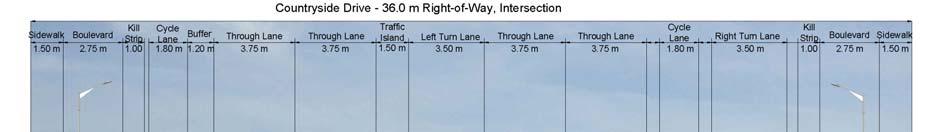
25 Alternative Cross-Sections Countryside Drive Jurisdiction City of Brampton Required number of lanes 4 SP47 TMP-Recommended Active On-road cycle lanes and sidewalks on Transportation Facilities both sides. 25


26 Alternative Cross-Sections Clarkway Drive, Castlemore Road to Main Street Jurisdiction City of Brampton Required number of lanes 4 SP47 TMP-Recommended Active On road cycles lanes, sidewalks on both Transportation Facilities sides 26


27 Alternative Cross-Sections Clarkway Drive, Main Street Jurisdiction City of Brampton Required number of lanes 4 SP47 TMP-Recommended Active On road cycles lanes, sidewalks on both Transportation Facilities sides! This Section of Clarkway is Subject to More Detailed Evaluation 27


28 Alternative Cross-Sections Clarkway Drive, East-West Arterial to Countryside Drive Jurisdiction City of Brampton Required number of lanes 2 SP47 TMP-Recommended Active On road cycle lanes, 1.5 m sidewalk on Transportation Facilities both sides 28


29 Alternative Cross-Sections Clarkway Drive, Countryside Drive to Mayfield Road Jurisdiction City of Brampton Required number of lanes 2-4 SP47 TMP-Recommended Active Multi-use path, sidewalks opposite side Transportation Facilities from multi-use path 29

30 Thank-you for your Participation! Next Steps 1. Your input is important! The project team will be determining preferred alternatives based on feedback from this PIC, technical investigations, and consultation with technical and regulatory agencies. 2. Complete the Environmental Inventory through field investigations to confirm findings of the SP47 Master Environmental Servicing Plan, particularly along the preferred alignments. 3. Develop the preferred design concepts and cross-sections. Using comments received at this PIC, as well as input from stakeholders and agencies, the conceptual designs for each arterial will be developed. 4. Present and gather input on the preliminary designs at PIC #2. The preliminary designs will be presented for further comment at:! PIC # 2 planned for spring Complete the preliminary designs. Based on feedback from PIC#2, as well as consultation with stakeholder groups and agencies, the conceptual designs will be modified and advanced to the preliminary design stage. Anticipated impacts and mitigation methods will be fully documented. 6. Prepare and file the Environmental Study Report. The Environmental Study Report will be prepared and available for review and comment during a 30 day review period. We Want to Hear From You! Let us know what is most important to you, your family and/or your business. Please complete the comment sheet and place it in the Comment Box or send your comments to one of the mailing or addresses listed on the comment sheet. Comment Deadline December 8th 30
Welcome to the Public Information Update for
 Welcome to the Public for 1 Tonight, we invite you to. Welcome to the Public 01 02 03 04 05 WelcomeL Sign-in and take a comment sheet Learn about the process. Review findings of previous studies. Learn
Bostwick Road. Municipal Class Environmental Assessment. October 13, City of London. Bostwick Road Municipal Class Environmental Assessment
 Bostwick Road Municipal Class Environmental Assessment October 13, 2016 Welcome! Welcome to the first Public Information Centre for the Bostwick Road Municipal Class Environmental Assessment. Representatives
St. Clair Avenue West Area Transportation Master Plan
 1 (Between Keele Street and Old Weston Road) Public Information Centre 1 December 2, 2015 2 Welcome Welcome to the first Public Information Centre for the St. Clair Avenue West Area. The panels will present
Municipal Class EA Study Public Information Centre No. 1 December 13, :00 pm 7:00 pm. Please sign in so we can keep you updated on this study
 Reconstruction of Regional Road 45 (Creek Road) Between Regional Road 27 (River Road) and Regional Road 63 (Canborough Road) in the Township of Wainfleet Municipal Class EA Study Public Information Centre
Heritage Road Improvements from Steeles Avenue to Rivermont Road
 The Corporation of the City of Brampton Heritage Road Improvements from Steeles Avenue to Rivermont Road Class Environmental Assessment Study (Schedule C) September 19, 2013 The Corporation of the City
Public Information Centre No. 1 King-Vaughan Road Bridge Replacement Municipal Class Environmental Assessment City of Vaughan
 Public Information Centre No. 1 King-Vaughan Road Bridge Replacement Municipal Class Environmental Assessment City of Vaughan Date: April 7, 2016 Location: Al Palladini Community Centre, Meeting Room #1
WELCOME TO OPEN HOUSE TWO November 28, 2018
 Langstaff Road Weston Road to Highway 7 Class Environmental Assessment Study WELCOME TO OPEN HOUSE TWO November 28, 2018 Please sign in and join our mailing list Study Overview York Region is conducting
Mavis Road Class Environmental Assessment
 Mavis Road Class Environmental Assessment Public Information Centre #2 Wednesday November 9, 2016 6:00 to 8:00 p.m. Please sign in and complete a comment sheet Review the displays on your own or join in
Bostwick Road. Municipal Class Environmental Assessment. Public Information Centre #2 June 14, City of London
 Bostwick Road Municipal Class Environmental Assessment Public Information Centre #2 June 14, 2017 Welcome! Welcome to the 2 nd Public Information Centre for the. Representatives from the and the consulting
McKay Road Interchange and Salem / Lockhart Crossing
 McKay Road Interchange and Salem / Lockhart Crossing The McKay Road Interchange Class EA has two components: 1. A new MacKay Road Interchange at Highway 400; and 2. A new bridge crossing of Highway 400
Better Cycling. The City will update the cycling master plan (London ON Bikes) based on the approved BRT network.
 based on the approved BRT network.") Better Cycling Dedicated bike facilities will be constructed along BRT corridors where space is available. Nearby bike routes will also be upgraded to ensure a complete network is available for cyclists.
Better Cycling Dedicated bike facilities will be constructed along BRT corridors where space is available. Nearby bike routes will also be upgraded to ensure a complete network is available for cyclists.
GEOMETRIC IMPROVEMENTS AND WATERMAIN LOOPING MUNICIPAL CLASS ENVIRONMENTAL ASSESSMENT
 GEOMETRIC IMPROVEMENTS AND WATERMAIN LOOPING MUNICIPAL CLASS ENVIRONMENTAL ASSESSMENT Veterans Way (previously Powerline Road) and Klondike Park Road Wasaga Beach Welcome Please sign in Take a comment
Portage Parkway Environmental Assessment Public Information Centre No. 1
 City of Vaughan Portage Parkway Environmental Assessment Public Information Centre No. 1 November 25, 2015 Welcome to the Public Information Centre This first Public Information Centre (PIC) introduces
The Gore Road Queen Street East to Castlemore Road
 Municipal Class Environmental Assessment The Gore Road Queen Street East to Castlemore Road Public Open House # 1 Date: Thursday May 29, 2014 Time: 5:30pm to 8:30pm Location: Gore Meadows Community Centre
Public Information Centre
 Public Information Centre Sunnidale Road Highway 400 Transmission i Watermain Crossing January 31, 2012 Sir Robert Barrie Room, 2 nd Floor, City Hall 4:00 pm to 7:00 pm As part of the Environmental Assessment
Commissioners Road West Realignment Environmental Assessment
 City of London Commissioners Road West Realignment Environmental Assessment Public Information Centre No. 1 March 30, 2017 Welcome to the Public Information Centre This first Public Information Centre
OFFICIAL PLAN DESIGNATIONS
 OFFICIAL PLAN DESIGNATIONS INDUSTRIAL generally east of Clarkway Dr RESIDENTIAL generally west of Clarkway Dr CORRIDOR PROTECTION AREA east of Clarkway Dr (for arterial network and high order transportation
WELCOME TO OPEN HOUSE # 3
 Bayview Avenue Class Environmental Assessment Study Steeles Avenue to Elgin Mills Road WELCOME TO OPEN HOUSE # 3 Please sign in and join our mailing list Why Are We Here Tonight? Study Process and Purpose
Public Information Centre #1
 and Highway 401 Interchange Improvements WELCOME Public Information Centre #1 Veterans Memorial Parkway Extension and Highway 401 Interchange Improvements Study May 23, 2012 4 p.m. to 7 p.m. Brief Overview
North York Centre South Service Road
 North York Centre South Service Road Municipal Class Environmental Assessment Addendum Potential Changes to Doris Avenue, Bonnington Place & Tradewind Avenue Study Summary (June 11, 2015) toronto.ca/nyc-south-road.
The West Vaughan Employment Area Secondary Plan Policies
 Part 2: The West Vaughan Employment Area Secondary Plan Policies 2.1 General Policies It is the policy of Council: 2.1.1. That the West Vaughan Employment Area (the WVEA), identified on Schedule 1, will
Vaughan Metropolitan Centre (VMC) Black Creek Renewal CLASS ENVIRONMENTAL ASSESSMENT
 Black Creek Renewal CLASS ENVIRONMENTAL ASSESSMENT") PUBLIC INFORMATION CENTRE Vaughan Metropolitan Centre (VMC) Black Creek Renewal Wednesday, May 10, 2017 6:00 p.m. to 8:00 p.m. Add photo Project Management, Environmental Assessment, Stormwater Management
PUBLIC INFORMATION CENTRE Vaughan Metropolitan Centre (VMC) Black Creek Renewal Wednesday, May 10, 2017 6:00 p.m. to 8:00 p.m. Add photo Project Management, Environmental Assessment, Stormwater Management
MAYFIELD WEST SECONDARY PLAN PHASE 2
 MAYFIELD WEST SECONDARY PLAN PHASE 2 Public Open House #3 February 25, 2010 Draft Preferred Land Use Scenario TOWN OF CALEDON PLANNING & DEVELOPMENT DEPARTMENT Open House Agenda TOWN OF CALEDON 1. Welcome
ENBRIDGE GAS DISTRIBUTION INC. Proposed Relocation for Ninth Line, Markham and Whitchurch-Stouffville. Environmental Screening Report
 Page 1 of 18 ENBRIDGE GAS DISTRIBUTION INC. Proposed Relocation for Ninth Line, Markham and Whitchurch-Stouffville Environmental Screening Report July 2011 Page 2 of 18 Table of Contents 1.0 INTRODUCTION
Baby Point Wastewater Pumping Station Forcemain Class Environmental Assessment Study
 Baby Point Wastewater Pumping Station Forcemain Class Environmental Assessment Study Public Drop-in Event 1 Thursday, October 12, 2017 6:00 p.m. to 8:00 p.m. Humbercrest United Church Welcome Welcome to
Public Information Centre. Welcome
 Transportation Improvements from the Beaver Creek Bridge to the Entrance of Santa s Village District of Muskoka Municipal Class Environmental Assessment Welcome Please sign in Take a comment sheet Staff
FANSHAWE PARK ROAD/RICHMOND STREET INTERSECTION IMPROVEMENTS. PUBLIC INFORMATION CENTRE 2 June 16, 2016
 FANSHAWE PARK ROAD/RICHMOND STREET INTERSECTION IMPROVEMENTS Municipal Class Environmental Assessment PUBLIC INFORMATION CENTRE 2 June 16, 2016 ACCESSIBILITY Under the Accessibility Standards 2015 for
Rapid Transit Implementation Working Group September 14, 2017
 Rapid Transit Implementation Working Group September 14, 2017 BACKGROUND Council approved the Rapid Transit Master Plan and Updated Business Case on July 25, 2017. Approval of the RTMP confirmed the BRT
Improvements Municipal Class Environmental Assessment. Public Information Centre #1 June 11, 2015
 Western Road & Sarnia Road/Philip Aziz Avenue Improvements Municipal Class Environmental Assessment Public Information Centre #1 June 11, 2015 1. Welcome We re hosting this Public Information Centre (PIC)
Commissioners Road West Realignment Environmental Assessment
 City of London Commissioners Road West Realignment Environmental Assessment Public Information Centre No. 2 November 29, 2017 Welcome to the Public Information Centre This 2 nd Public Information Centre
Inform you of the purpose and scope of the study for PTH 100 and a proposed future St. Norbert Bypass;
 WELCOME The intent of today s Open House is to: Inform you of the purpose and scope of the study for PTH 100 and a proposed future St. Norbert Bypass; Review highway crossing locations, future access closures
COUNCIL ATTACHMENT 2 HIGHWAY 7 CORRIDOR AND VAUGHAN NORTH-SOUTH LINK
 COUNCIL ATTACHMENT 2 HIGHWAY 7 CORRIDOR AND VAUGHAN NORTH-SOUTH LINK Welcome! The purpose today is to: Present the Study Background; Describe Alignment Alternatives Analyzed; Present the Evaluation of
CONSULTING SERVICES FOR THE WHITEBELT VISIONING EXERCISE ADDENDUM TO THE GTA WEST LAND USE STUDY WORK PROGRAM
 CONSULTING SERVICES FOR THE WHITEBELT VISIONING EXERCISE ADDENDUM TO THE GTA WEST LAND USE STUDY 1. Introduction WORK PROGRAM The Town of Caledon is a large, local municipality located in the Greater Toronto
Introduction. Public Information Package. Project website. Overview. Class Environmental Assessment Process
 1 Introduction Public Information Package Baseline Road Extension between Lambs Road and Bennett Road, Bowmanville Schedule B Municipal Class Environmental Assessment November 6, 2017 Overview The purpose
The purpose of tonight s PIC is to:
 The purpose of tonight s PIC is to: Provide an overview of the work completed to date and a summary of the Class EA process being followed; Provide a summary of public input received so far, including
MAYFIELD WEST SECONDARY PLAN PHASE 2
 MAYFIELD WEST SECONDARY PLAN PHASE 2 Council Information Workshop February 16, 2010 Draft Preferred Land Use Plan TOWN OF CALEDON PLANNING & DEVELOPMENT DEPARTMENT Workshop Agenda TOWN OF CALEDON 1. Welcome
Northeast Anthony Henday Drive Manning Freeway to Whitemud Drive Welcome to this Construction Information Session
 Manning Freeway to Whitemud Drive Welcome to this Construction Information Session Purpose To inform interested residents and businesses about the plans accommodation. Background: The Government of Alberta
Lower Don River West Remedial Flood Protection Project TABLE OF CONTENTS. Page. Executive Summary
 TABLE OF CONTENTS Page Executive Summary 1.0 INTRODUCTION...1-1 1.1 Purpose of the Undertaking...1-1 1.2 Study Area Description...1-1 1.3 Description of the Undertaking...1-1 1.4 Rationale for the Undertaking...1-2
The Illinois Department of Transportation and Lake County Division of Transportation. Route 173, including the Millburn Bypass
 The Illinois Department of Transportation and Lake County Division of Transportation welcome you to this Public Hearing for U.S. Route 45 from Illinois Route 132 to Illinois Route 173, including the Millburn
SUMMARY ASSESSMENT MATRIX
 ASSESSMENT MATRIX Legend: Least Preferred Most Preferred Natural Environment Terrestrial Ecosystems Avoids regulated SAR habitat. Avoids regulated SAR habitat. Avoids creating a new crossing of the features.
Emery Village Road 2A Municipal Class Environmental Assessment Study
 PW12.11 STAFF REPORT ACTION REQUIRED Emery Village Road 2A Municipal Class Environmental Assessment Study Date: March 30, 2016 To: From: Wards: Reference Number: Public Works and Infrastructure Committee
NORTHEAST RIVER CROSSING FUNCTIONAL PLANNING STUDY
 WELCOME Northeast River Crossing Functional Planning Study Phase 2 Public Meeting 4 to 8 PM Informal drop-in format and discussion tables Meeting Purpose Introduce the Northeast River Crossing Functional
Master Environmental Servicing Plan & Secondary Plan
 East Side Lands Stage 2 1 Master Environmental Servicing Plan & Secondary Plan Public Information Centre #1 June 16, 2016 Welcome! Today s Agenda Please sign in at the front desk. 5:30 pm 6:30 pm: Open
SPECIAL COMMITTEE OF THE WHOLE DECEMBER 9, 2002 BLOCK 57/58 WEST BLOCK PLAN BLOCK PLAN FILE BL.57/58W.99 HUNTINGTON BUSINESS PARK LAND OWNERS
 SPECIAL COMMITTEE OF THE WHOLE DECEMBER 9, 2002 BLOCK 57/58 WEST BLOCK PLAN BLOCK PLAN FILE BL.57/58W.99 HUNTINGTON BUSINESS PARK LAND OWNERS Recommendation The Commissioner of Planning recommends: THAT
City of Cornwall Municipal Class Environmental Assessment. Proposed Improvement and Extension of Lemay Street
 Welcome City of Cornwall Municipal Class Environmental Assessment Proposed Improvement and Extension of Lemay Street Redevelopment and Design of the Municipal Works Yard Public Information Centre #1 Thursday,
City of Toronto. Emery Village Transportation Master Plan
 City of Toronto Emery Village Transportation Master Plan May 2009 Emery Village Transportation Master Plan Toronto, ON May 2009 Consulting Inc. 100 York Blvd., Suite 300 Richmond Hill, ON L4B 1J8 Tel:
Blackfriars Bridge Municipal Class Environmental Assessment. Public Information Centre #1 November 19 th, 2014
 Blackfriars Bridge Municipal Class Environmental Assessment Public Information Centre #1 November 19 th, 2014 Why are you here tonight? To determine the future requirements of the river crossing at Blackfriars
Public Information Centre No.2. Bram West Parkway. From Financial Drive to Heritage Road. and. Financial Drive
 WELCOME Public Information Centre No.2 Bram West Parkway From Financial Drive to Heritage Road and Financial Drive From Heritage Road to Winston Churchill Boulevard Municipal Class Environmental Assessment
Adelaide Street / Canadian Pacific Railway (CPR) Grade Separation Class Environmental Assessment. Public Information Centre 3
 Grade Separation Class Environmental Assessment. Public Information Centre 3") 1 Adelaide Street / Canadian Pacific Railway (CPR) Grade Separation Study Process and Purpose of PIC 3 2 Study Commencement February 2016 Phase 1: Problem and Opportunity Identify problems and opportunities
1 Adelaide Street / Canadian Pacific Railway (CPR) Grade Separation Study Process and Purpose of PIC 3 2 Study Commencement February 2016 Phase 1: Problem and Opportunity Identify problems and opportunities
Station Street/Haig Road Extension Environmental Assessment (EA)Study. Welcome
Study. Welcome") Station Street/Haig Road Extension Environmental Assessment (EA)Study Welcome Welcome to this Public Information Centre (PIC) meeting. Please record your attendance and obtain a comment sheet at the registration
Station Street/Haig Road Extension Environmental Assessment (EA)Study Welcome Welcome to this Public Information Centre (PIC) meeting. Please record your attendance and obtain a comment sheet at the registration
3 Development Process 3.1 Stage One page Stage Two page Stage Three page CENTRAL PICKERING DEVELOPMENT PLAN
 3 Development Process 3.1 Stage One page 24 3.2 Stage Two page 25 3.3 Stage Three page 28 22 CENTRAL PICKERING DEVELOPMENT PLAN The Central Pickering Development Plan establishes the key elements of new
Second Line West Pedestrian/Cyclist Crossing of Highway 401 Class EA. Second Line West Pedestrian/Cyclist Crossing of Highway 401 Class EA
 1 1 Purpose of Public Information Centre #2 To provide interested and/or potentially affected stakeholders with an opportunity to participate in the planning and decision-making process for this Municipal
12 AMENDMENT NO. 149, TOWN OF MARKHAM HIGHWAY 404 NORTH SECONDARY PLAN
 12 AMENDMENT NO. 149, TOWN OF MARKHAM HIGHWAY 404 NORTH SECONDARY PLAN The Planning and Economic Development Committee recommends the adoption of the recommendation contained in the following report August
Elfrida Growth Area Study
 Elfrida Growth Area Study Public Information Centre #2 December 6, 2017 6:00-8:30 pm PLANNING & ECONOMIC DEVELOPMENT DEPARTMENT Purpose of the Study The Elfrida Area has been identified as the preferred
WELCOME! 8 8:30 6: TH STREET IMPROVEMENTS. Open House. Presentation & Q&A
 WELCOME! 168 TH STREET IMPROVEMENTS 6:30 Open House 7 8 Presentation & Q&A 8 8:30 Open House WELCOME Todd Pfitzer City of Omaha Engineer Bob Stubbe City of Omaha Public Works Director Jon Meyer Project
Rapid Transit Implementation Working Group
 Rapid Transit Implementation Working Group October 12, 2017 1 Agenda 1. Consultation Update 2. Technical Work Update 3. LTC Rapid Transit Integration 4. Next Steps 2 Consultation Update 3 Consultation
Environmental Study Report
 Environmental Study Report Britannia Road (Regional Road 6) Transportation Corridor Improvements The Regional Municipality of Halton TN1390TNA00 The Regional Municipality of Halton 1151 Bronte Road Oakville,
AMENDMENT NO. 30 TO THE OFFICIAL PLAN OF THE TOWN OF MILTON
 AMENDMENT NO. 30 TO THE OFFICIAL PLAN OF THE TOWN OF MILTON Subject: Boyne Survey Secondary Plan and Related Official Plan Amendments The following text and schedules constitute Amendment No. 30 to the
Services Department B September 10, 2007
 Report To: Development Services Committee Item: Date of Report: DS-07-246 September 5, 2007 From: Commissioner, Development File: Date of Meeting: Services Department B7200-0001 September 10, 2007 Subject:
Western Road/Wharncliffe Road North Widening from Platts Lane to Oxford Street. Municipal Class Environmental Assessment Public Information Centre #1
 Western Road/Wharncliffe Road North Widening from Platts Lane to Oxford Street Municipal Class Environmental Assessment Public Information Centre #1 June 11, 2014 Welcome Welcome to the first Public Information
Recreational Pathway Crossing of Richmond Street Municipal Class Environmental Assessment. Public Information Centre #2 April 22, 2015
 Recreational Pathway Crossing of Richmond Street Municipal Class Environmental Assessment Public Information Centre #2 April 22, 2015 1. Study Process PHASE 1 PHASE 2 PHASE 3 PHASE 1 : Problem/Opportunity
Master Environmental Servicing Plan & Secondary Plan
 1 East Side Lands Stage 2 Master Environmental Servicing Plan & Secondary Plan Public Consultation Centre #4 March 20, 2018 Welcome! Today s Agenda Please sign in at the registration table. 6:00 pm 6:30
1.0 INTRODUCTION AND BACKGROUND
 1.0 INTRODUCTION AND BACKGROUND 1.1 INTRODUCTION / BACKGROUND The Regional Municipality of York (hereafter referred to as York Region ) has completed a Municipal Class Environmental Assessment (Class EA)
ONLINE PUBLIC INFORMATION CENTRE
 ONLINE PUBLIC INFORMATION CENTRE County Road 17 Bridge Replacements Detail Design and Environmental Assessment GWP 4203-15-00 The Ministry of Transportation Ontario (MTO) has retained CH2M Hill and Dillon
Appendix B-13: Community Stakeholders Group Meeting Materials and Minutes
 Appendix B-13: Community Stakeholders Group Meeting Materials and Minutes PREPARED BY IBI Group and WSP London s Rapid Transit Initiative Community Stakeholder Group Meeting Summary Report for October
Master Plan Class Environmental Assessment for Downtown Mississauga Road Improvements
 Master Plan Class Environmental Assessment for Downtown Mississauga Road Improvements Public Information Centre # 1 Wednesday June 25, 2014 5:30 p.m. to 8:00 p.m. Mississauga Civic Centre Great Hall Welcome
NEW REGIONAL OFFICIAL PLAN HIGH LEVEL PROCESS & FRAMEWORK
 NEW REGIONAL OFFICIAL PLAN HIGH LEVEL PROCESS & FRAMEWORK Why A New Official Plan Originally the role of Regionally Planning and content of Regional Official Plan (1970s) primarily focused on protecting
HAZARD MITIGATION GOALS AND OBJECTIVES
 SEWRPC Community Assistance Planning Report No. 282, 2nd Edition CITY OF MILWAUKEE ALL HAZARDS MITIGATION PLAN UPDATE Chapter IV HAZARD MITIGATION GOALS AND OBJECTIVES [NOTE: Throughout this plan update
Issues Requiring Future Study
 Issues Requiring Future Study Transportation planning is an ongoing process that tends to identify new issues as it finds solutions for others. Some issues are so complex that a solution to one problem
9 CITY OF VAUGHAN OFFICIAL PLAN AMENDMENT NO BOCA EAST INVESTMENTS LIMITED
 9 CITY OF VAUGHAN OFFICIAL PLAN AMENDMENT NO. 631 - BOCA EAST INVESTMENTS LIMITED The Planning and Economic Development Committee recommends the adoption of the recommendations contained in the following
Adelaide Street / Canadian Pacific Railway (CPR) Grade Separation. Public Information Centre #1
 Grade Separation. Public Information Centre #1") 1 Adelaide Street / Canadian Pacific Railway (CPR) Why Are We Here? 2 The purpose of Public Information Centre (PIC) #1 is to: Introduce the study Provide the study background and context Identify the
1 Adelaide Street / Canadian Pacific Railway (CPR) Why Are We Here? 2 The purpose of Public Information Centre (PIC) #1 is to: Introduce the study Provide the study background and context Identify the
TABLE OF CONTENTS Page
 TABLE OF CONTENTS Table of Contents Page 1 INTRODUCTION... 1-1 1.1 Introduction and Background... 1-1 1.1.1 Current Class Environmental Assessment Study... 1-1 1.2 Study Area (Section 1)... 1-3 1.3 Ontario
PROJECT STATEMENT LOCATION/DESIGN PUBLIC HEARING. 19 th AVENUE NORTH EXTENSION PROJECT FROM SPRINGDALE DRIVE TO NORTH 2 ND STREET/U.S.
 PROJECT STATEMENT LOCATION/DESIGN PUBLIC HEARING 19 th AVENUE NORTH EXTENSION PROJECT FROM SPRINGDALE DRIVE TO NORTH 2 ND STREET/U.S. 67 HEARING LOCATION: ERICKSEN COMMUNITY CENTER 1401 11 TH AVENUE NORTH
TRCA Roles and Responsibilities in Planning and Development
 TRCA Roles and Responsibilities in Planning and Development Regional Watershed Alliance November 14, 2018 Laurie Nelson, MCIP, RPP Associate Director, Planning and Policy Outline Roles and Legislation
AMENDMENT NO. 38 TO THE CITY OF BARRIE OFFICIAL PLAN SALEM SECONDARY PLAN. June 2014
 AMENDMENT NO. 38 TO THE CITY OF BARRIE OFFICIAL PLAN SALEM SECONDARY PLAN June 2014 AMENDMENT NO. 38 TO THE OFFICIAL PLAN OF THE BARRIE PLANNING AREA TABLE OF CONTENTS Page Introduction 1 Part A - The
WELCOME TO THE PUBLIC INFORMATION CENTRE. Please Sign In
 WELCOME TO THE PUBLIC INFORMATION CENTRE Replacement of Oxtongue Lake Narrows Bridge & Oxtongue River Bridge, Highway 60 (G.W.P. 93-89-00 & G.W.P. 5550-04-00) Class Environmental Assessment (Group B) Please
Toronto Complete Streets Guidelines
 Toronto Complete Streets Guidelines 108 110 7.1 Green Infrastructure Design Principles 112 7.2 Context-Sensitive Green Streets 114 7.3 Key Green Street Elements Green infrastructure refers to natural and
Strasburg Road Extension (North of Stauffer Drive to New Dundee Road)
") Strasburg Road Extension (North of Stauffer Drive to New Dundee Road) DRAFT ENVIRONMENTAL STUDY REPORT (Summarized Version) Introduction In April 2010, the City of Kitchener initiated a class environmental
Strasburg Road Extension (North of Stauffer Drive to New Dundee Road) DRAFT ENVIRONMENTAL STUDY REPORT (Summarized Version) Introduction In April 2010, the City of Kitchener initiated a class environmental
Gold Line Bus Rapid Transit Transit Oriented Development (BRTOD) Helmo Station Area Plan
 Helmo Station Area Plan") Appendix F Gold Line Bus Rapid Transit Transit Oriented Development (BRTOD) Helmo Station Area Plan Introduction and Purpose of the Plan The Gold Line Bus Rapid Transit facility is an eleven-mile dedicated
Appendix F Gold Line Bus Rapid Transit Transit Oriented Development (BRTOD) Helmo Station Area Plan Introduction and Purpose of the Plan The Gold Line Bus Rapid Transit facility is an eleven-mile dedicated
Integration of Trees into Roads Policy - the road to success -
 Integration of Trees into Roads Policy - the road to success - Trees, People and the Built Environment 3 City of Birmingham, UK April 5 th, 2017 Ian Buchanan Natural Heritage and Forestry Regional Municipality
FURTHER TO EXECUTIVE COMMITTEE MEETING #11/12 To be held on Friday, January 11, 2013
 FURTHER TO EXECUTIVE COMMITTEE MEETING #11/12 To be held on Friday, January 11, 2013 FURTHER TO: Pages EX10. APPLICATION FOR PERMITS UNDER ONTARIO REGULATION 166/06 Development, Interference with Wetlands
PREPARED FOR: PLATTEVIEW ROAD CORRIDOR STUDY EXECUTIVE SUMMARY
 PREPARED FOR: PLATTEVIEW ROAD CORRIDOR STUDY EXECUTIVE SUMMARY SEPTEMBER 2016 Introduction The Platteview Road Corridor Study was led by the Metropolitan Area Planning Agency (MAPA) with assistance from
Red Hill Valley Project More Than A Road October 16, 2006
 Red Hill Valley Project Presented By: More Than A Road October 16, 2006 September, 2007 Gerry Davis, C.M.A., Senior Director, Capital Planning and Implementation Division Public Works Department City of
PROJECT BACKGROUND. Preliminary Design Scope and Tasks
 PROJECT BACKGROUND Preliminary Design Scope and Tasks The purpose of this Study is the development of preliminary designs for intersection improvements for Trunk Highway (TH) 36 at the intersections of
SCARBOROUGH RAPID TRANSIT ENVIRONMENTAL PROJECT REPORT CHAPTER 2 PROJECT DESCRIPTION. Table 2-4: North Segment Alignment Analysis 2-21
 Table 2-4: North Segment Alignment Analysis 2-21 SCARBOROUGH RAPID TRANSIT Based on the above analysis (detailed analysis is contained in Appendix A-4), North Alignment 3 is preferred because it: Has the
Services Department F May 28, 2007
 Report To: Development Services Committee Item: Date of Report: From: DS-07-144 May 23, 2007 Commissioner, Development File: Date of Meeting: Services Department F-7000-0013 May 28, 2007 Subject: Gibb
MOUNT PLEASANT SECONDARY PLAN & VILLAGE BLOCK PLAN. Wednesday, March 5, 2008 Informal Public Open House
 MOUNT PLEASANT SECONDARY PLAN & VILLAGE BLOCK PLAN Wednesday, March 5, 2008 Informal Public Open House 1. Welcome & Introductions 2. Highlights of Provincial Growth Plan 3. Overview and Status Update -
Cherry Beach Shoreline Protection Infrastructure Conceptual Design and Class EA
 Welcome Cherry Beach Shoreline Protection Infrastructure Conceptual Design and Class EA May 3, 2012 Study Area Cherry Beach neighbourhood is located in lower Stoney Creek on Lake Ontario, east of Millen
CITY COUNCIL AGENDA REPORT
 CITY COUNCIL AGENDA REPORT Subject: COUNCIL MOTION LRT ALIGNMENT REMOVAL FROM THE TRANSPORTATION MASTER PLAN On February 10, 2016 Councillor Hughes provided notice in accordance with Section 23 of Procedure
Planning for the Future Urban Area. in north Markham. Update. Development Services Committee. December 9, De Development Services Committee
 Planning for the in north Markham 1 Update De December 9, 2014 Overview - Growth Management Strategy and new Official Plan 2014 Status - Official Plan 2014 and ROPA3 Update - Planning for the Future Urban
Public Meeting #3 May 9, 2009 MVVA Team
 Public Meeting #3 May 9, 2009 MVVA Team Welcome to the third Public Meeting for the Lower Don Lands Municipal Class Environmental Assessment (EA) Infrastructure Master Plan and Keating Channel Precinct
Purpose of Open House #3
 Public Meeting #3 May 9, 2009 MVVA Team Purpose of Open House #3 The main purpose of this Open House is to present and seek input on the: Evaluation of transportation and infrastructure design alternatives
Project Overview. Get Involved. Public Information Meeting. Contact Information
 Get Involved VDOT representatives will review and evaluate information received as a result of this meeting. Please fill out the comment sheet provided in this brochure if you have any comments or questions.
NORTH-SOUTH CORRIDOR STUDY EXECUTIVE SUMMARY. Executive Summary
 Executive Summary Background As congestion continues to affect mobility in the region, the Ozarks Transportation Organization (OTO) is particularly concerned with traffic movement. The North-South Corridor
Welcome. Date: Thursday March 2, 2017 Time: 6:30 p.m. 9:00 p.m. Location: Woodview School Gym, 69 Flatt Road, Burlington Presentation Time: 7:00 p.m.
 Welcome Public Information Centre No.2 City of Burlington, City of Hamilton, Region of Halton Waterdown Road Widening Detailed Design Craven Avenue to Mountain Brow Road Date: Thursday March 2, 2017 Time:
Burloak Drive Grade Separation
 Burloak Drive Grade Separation Transit Project Assessment Process Public Meeting #1 March 30, 2017 GO Lakeshore West Service Plan Weekday Rush Hour 15-minute, two-way service between Aldershot* and Union
Elevated Water Storage Facility and Pumping Station Municipal Class EA for Pressure District 7: PIC # 1 Summary
 Memorandum DATE: March 14, 2018 TO: FROM: CC: OUR REF.#: SUBJECT: Winston Wang, M.A.Sc., P.Eng Project Manager, City of Hamilton Jennifer Whittard, B.E.S., PMP Shelley Kuan, Jessica Mollo WM16-0435 Elevated
APPENDIX K WINDSOR OFFICIAL PLAN
 CEAA ENVIRONMENTAL ENVIRONMENTAL IMPACT ASSESSMENT AMBASSADOR BRIDGE ENHANCEMENT PROJECT Replacement Span and Plaza Expansion APPENDIX K WINDSOR OFFICIAL PLAN Avalon Consulting Professionals of Ontario,
APPENDIX I Presentations
 APPENDIX I Presentations Workshop Summary Report 11 Peel Region Official Plan Review May 5, 2010 Compatible Active Recreation Workshop July 29, 2010 Components of PROPR Sustainability Planning Tools/Updates
PUBLIC HEARING. Thursday, December 14, 2017 FDOT Urban Office 2198 Edison Avenue Jacksonville, FL 32204
 DISTRICT TWO PUBLIC HEARING I 10 (SR 8) from I 295 to I 95 Project Development & Environment Study Duval County, Florida Financial Project Number 213326 2 22 01 Efficient Transportation Decision Making