MASTER PLAN NO. 60 (SITE DEVELOPMENT PLAN EASTBANK/REGATTA NORTH PRECINCTS 2 4) 2008
|
|
|
- Chad Logan
- 6 years ago
- Views:
Transcription
1
2 Page 2 TABLE OF CONTENTS PAGE 1 PRELIMINARY CITATION TYPE OF MASTER PLAN LEGAL REQUIREMENT FOR MASTER PLAN LEGAL EFFECT OF THE MASTER PLAN DESCRIPTION OF LAND LOCATION AND DESCRIPTION ZONING MAP DESCRIPTION STRATEGIC PLAN DESCRIPTION DCP DESCRIPTION APPLICATION OF MASTER PLAN RELATIONSHIP TO HIGHER ORDER MASTER PLANS RELATIONSHIP TO DCP RELATIONSHIP TO PLANNING SCHEME PROVISIONS STRUCTURE OF MASTER PLAN CONTENT OF SITE DEVELOPMENT PLAN SUBDIVISION LAYOUT DEFINED USES DEFINED USES DEVELOPMENT CRITERIA MOVEMENT NETWORKS BUILDING LAYOUT OPEN SPACE ACCESS AND PARKING IMPLEMENTATION OF URBAN DESIGN PERFORMANCE CRITERIA... 11
3 Page GENERAL LOT LAYOUT BUILDING DESIGN AND APPEARANCE LANDSCAPE / OPEN SPACE CAR PARKING AND ACCESS MOVEMENT NETWORKS ACOUSTIC QUALITY REFUSE MANAGEMENT STORMWATER FLOOD MANAGEMENT SEWERAGE DISPOSAL IMPLEMENTATION OF SITE DEVELOPMENT PLAN DESIGN PARAMETERS REQUIREMENT FOR A SITE DEVELOPMENT PLAN DEVELOPMENT WITHIN A SITE DEVELOPMENT PLAN CONTENT OF A SITE DEVELOPMENT PLAN MAPS AND TABLES STATEMENT OF COMPLIANCE REQUIREMENTS THE STRUCTURE PLAN MASTER PLAN DETERMINATION NO. 1 (APPROVAL OF STRUCTURE PLAN) THE PLANNING SCHEME INCLUDING DCP DEVELOPMENT AGREEMENT DEVELOPMENT LEASE NO MASTER PLAN NO. 14 (DETAILED PLANNING AREA PLAN EASTBANK / REGATTA NORTH) RELAXATIONS INTERPRETATION RULES SUPPORTING INFORMATION TABLE 1: SUPPLEMENTARY TABLE OF DEVELOPMENT PRECINCTS
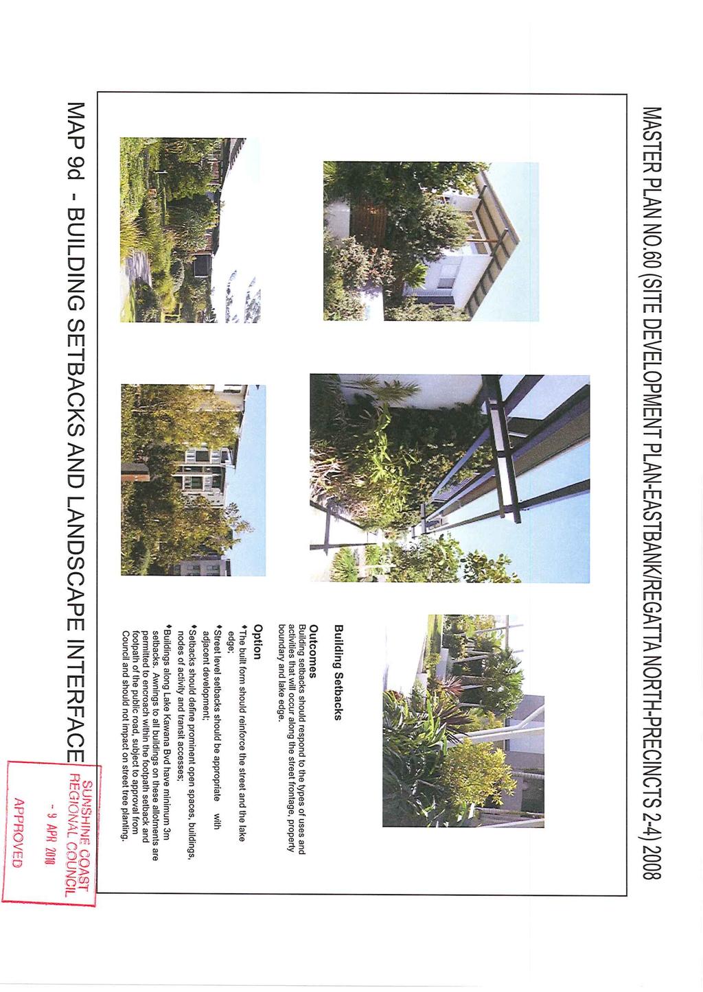
4 Page 4 LIST OF MAPS Map 1 Locality 33 Map 2 Land Subject of Master Plan 34 Map 3 Land Use Areas 35 Map 4 Site Development Plan 36 Map 5 Landscape Concept Plan 37 Map 6 Vehicular Movement Network 38 Map 7 Pedestrian/Cyclist Movement Network 39 Map 8 Dimensions Plan 40 Map 9(a) Building Bulk and Scale 41 Map 9(b) Street Address 42 Map 9(c) Architectural Character 43 Map 9(d) Building Setbacks and Landscape Infrastructure 44
5 Page 5 1 PRELIMINARY 1.1 Citation This document may be cited as Master Plan No. 60 (Site Development Plan Eastbank/Regatta North Precincts 2-4) Type of Master Plan This document contains a Site Development Plan for Precincts 2, 3 and 4 of Detailed Planning Area 1 as identified in Master Plan No. 14 (Detailed Planning Area Plan Eastbank / Regatta North) Legal Requirement for Master Plan A Site Development Plan is required to be prepared in respect of those parts of DPA 1 identified on Master Plan No. 14 (Detailed Planning Area Plan Eastbank / Regatta North) 2001, as requiring a Site Development Plan, pursuant to Section of DCP Legal Effect of the Master Plan The Site Development Plan comprises: a) This document which shows the subdivision layout with lot boundaries, the purpose for which the lot may be developed, the movement network including pedestrian and cyclist linkages, building set backs, building layout criteria, open space provision and access and parking; b) A supplementary table of development consistent with DCP1; and c) Maps 1-9 which show in more detail the elements to be identified as required by Section of DCP1.
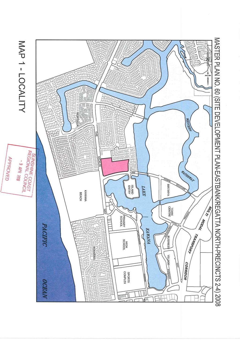
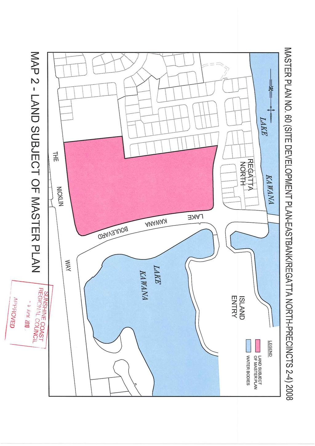
6 Page 6 2 DESCRIPTION OF LAND 2.1 Location and Description The land the subject of this Master Plan is bound by the Nicklin Way to the east, low density residential precincts and the Kawana Bowls Club to the south and west and Lake Kawana Boulevard to the north Map 1 Locality shows the land the subject of this Master Plan, relative to its surrounds as described above, while Map 2 Land Subject of Master Plan shows the extent of the area covered by this application The land the subject of this Master Plan is described as Lot 521 on SP176150, all in the Parish of Bribie and being leasehold land within Development Lease No The area of land subject of this Site Development Plan is approximately hectares. 2.2 Zoning Map Description The land the subject of the Site Development Plan is zoned Special Development under the Planning Scheme for Caloundra City. 2.3 Strategic Plan Description The land the subject of the Site Development Plan is identified in the Strategic Plan of the Planning Scheme for Caloundra City as having a preferred dominant land use of Urban. 2.4 DCP Description The land the subject of the Site Development Plan is also designated as part of Detailed Planning Area 1 on Map 3 of DCP1 and its intent is described under Section (b) of DCP1.
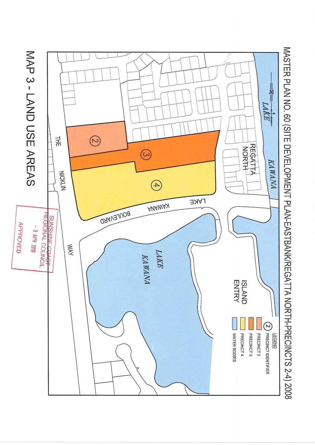
7 Page 7 3 APPLICATION OF MASTER PLAN 3.1 Relationship to Higher Order Master Plans The land the subject of the Site Development Plan is subject to the Structure Plan Maps and as such is: identified on Structure Plan Map 1 as having a land use defined by Detailed Planning Area 1 of DCP1; and subject to Structure Plan Map 2 which shows the area as having pedestrian/cyclist links; and subject to Structure Plan Map 4 which shows the area as having a Village/Neighbourhood Relationship, being Neighbourhood 4 in Village 1; and subject to Detailed Planning Area Plan, Master Plan No. 14 (Detailed Planning Area Plan Eastbank / Regatta North) 2001 which shows the area on Map 3 (Land Use Area Precincts) as Precinct 2, 3 & 4 of DPA Relationship to DCP The land the subject of the Site Development Plan is subject to DCP1 and as such identified on DCP1, Map 1 as being part of Detailed Planning Area 1 with the preferred land uses described in Section (b) of DCP1; and DCP1, Map 4 identifies the subject area as being part of Precinct 3 where the maximum population shall not exceed 9,025 persons for the whole of the Precinct (This population threshold can be exceeded by 10%). 3.3 Relationship to Planning Scheme Provisions The land the subject of the Site Development Plan is subject to:
8 Page Zoning Maps identify the land the subject of the Site Development Plan as being included in the Special Development Zone; The Table of Development in Section 2.7 (2) (Special Development Zone) of the Planning Scheme specifies the purposes for which the premises may be used in accordance with a Supplementary Table of Development pursuant to DCP1; Part 6 of the Planning Scheme which contains provisions relating to the reconfiguring of lots in the Special Development Zone. 4 STRUCTURE OF MASTER PLAN 4.1 Content of Site Development Plan This Site Development Plan comprises: Subdivision layout with lot boundaries as specified in Section 5 (Subdivision Layout) of this document; The purpose for which each lot is to be developed as specified in Section 6 (Defined Uses) of this document; Movement Networks including pedestrian and cyclist linkages as specified in Section 7 (Movement Networks) of this document; Building Layout Criteria as specified in Section 8 (Building Layout) of this document; Open Space Provision as specified in Section 9 (Open Space) of this Document; Access and Parking Provision as specified in Section 10 (Access and Parking) of this document; Implementation of Urban Design Performance Criteria as specified in Section 11 (Implementation of Urban Design Performance Criteria) of this document;
9 Page Implementation of Site Development Plan Design Parameters as specified in Section 12 (Implementation of Site Development Plan Design Parameters) of this document; Maps as specified in Section 13 (Maps and Tables) of this document; Statement of Compliance as specified in Section 14 (Statement of Compliance) of this document; Interpretation Rules as specified in Section 15 (Interpretation Rules) of this document; and Supporting Information as specified in Section 16 (Supporting Information) of this document. 5 SUBDIVISION LAYOUT The Subdivision Layout with lot boundaries for the Site Development Plan is indicated on Map 8 (Dimensions Plan) of this document. 6 DEFINED USES 6.1 Defined Uses The land the subject of the Site Development Plan shall be developed from the defined uses specified in Section 17 Table 1 - Supplementary Table of Development of this Document The western portion of Precinct 3 and 4 may be used as a temporary Car Park until such time as the site is developed to its ultimate land use intent or 31 December 2017, whichever occurs earlier. The temporary car park use must not exceed its operational period as stated above, without the approval of Council and the Master Developer.
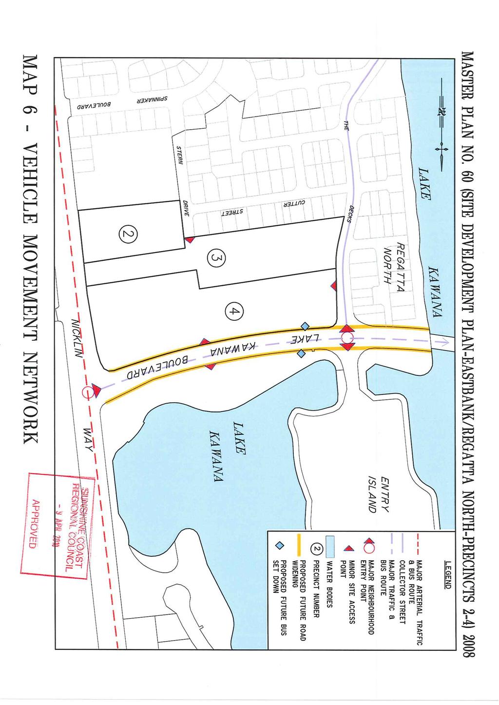
10 Page Development Criteria The land the subject of the Site Development Plan shall be subject to the controls specified in the Supplementary Table of Development, being part of this document and Table 1 Precinct 2, 3 & 4 of Master Plan No 14 (Detailed Planning Area Plan Eastbank / Regatta North) The land, the subject of the Site Development Plan, shall be subject to the Development Criteria specified in Section 6.2 (Development Criteria) of Master Plan No. 14 (Detailed Planning Area Plan Eastbank / Regatta North) MOVEMENT NETWORKS Movement Networks including pedestrian and cyclist linkages are indicated on Map 6 (Vehicular Movement Network) and Map 7 (Pedestrian/Cyclist Movement Network) of this document. 8 BUILDING LAYOUT Buildings layouts are not defined on the Site Development Plan and should be provided as part of a Material Change of Use application. Implementation of Urban Design Performance Criteria in Section 11 of this document provides controls on building setback, building layout, parking requirements, landscaping and will dictate to a great extent, the layout and design of buildings. 9 OPEN SPACE Communal and private open space is provided and the development is landscaped so that residents have sufficient area to: (a) engage in communal activities; (b) engage in active uses that meet resident needs;
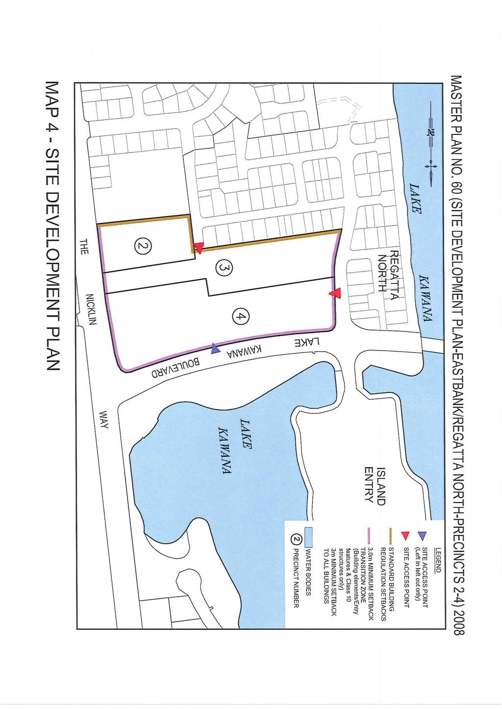
11 Page 11 (c) provide access to direct sunlight; (d) enjoy private and semi private spaces; and (e) accommodate visitors The landscape concept for the open space is detailed on Map 5 - Landscape Concept Plan. 10 ACCESS AND PARKING Vehicular access to development areas is restricted to those points nominated on Map 6 Vehicular Movement Network of this document. Provision for parking is controlled through Section 7.0 Urban Design Performance Criteria in Master Plan No. 14 (Detailed Planning Area Plan Eastbank / Regatta North) 2001 and Section 11 Implementation of Urban Design Performance Criteria of this document. Direct access for pedestrians and cyclists from the site to the surrounding road network and pathways are indicated for each precinct on Map 7 Pedestrian / Cyclist Movement Network. These access points can be relocated or consolidated to more appropriate positions if development occurs across precinct boundaries and/or to align with current or future transport infrastructure. 11 IMPLEMENTATION OF URBAN DESIGN PERFORMANCE CRITERIA 11.1 General The Urban Design Performance Criteria defined in Section 7.0 of Master Plan No. 14 (Detailed Planning Area Plan Eastbank / Regatta North) 2001 will be implemented in the Site Development Plan in accordance with the requirements detailed in the following Sections of this document Lot Layout The current lot layout is shown on Map 8 (Dimensions Plan) of this Site Development Plan as being a single lot 521 with an area of hectares. Any changes to this lot layout should be in consideration of the proposed road
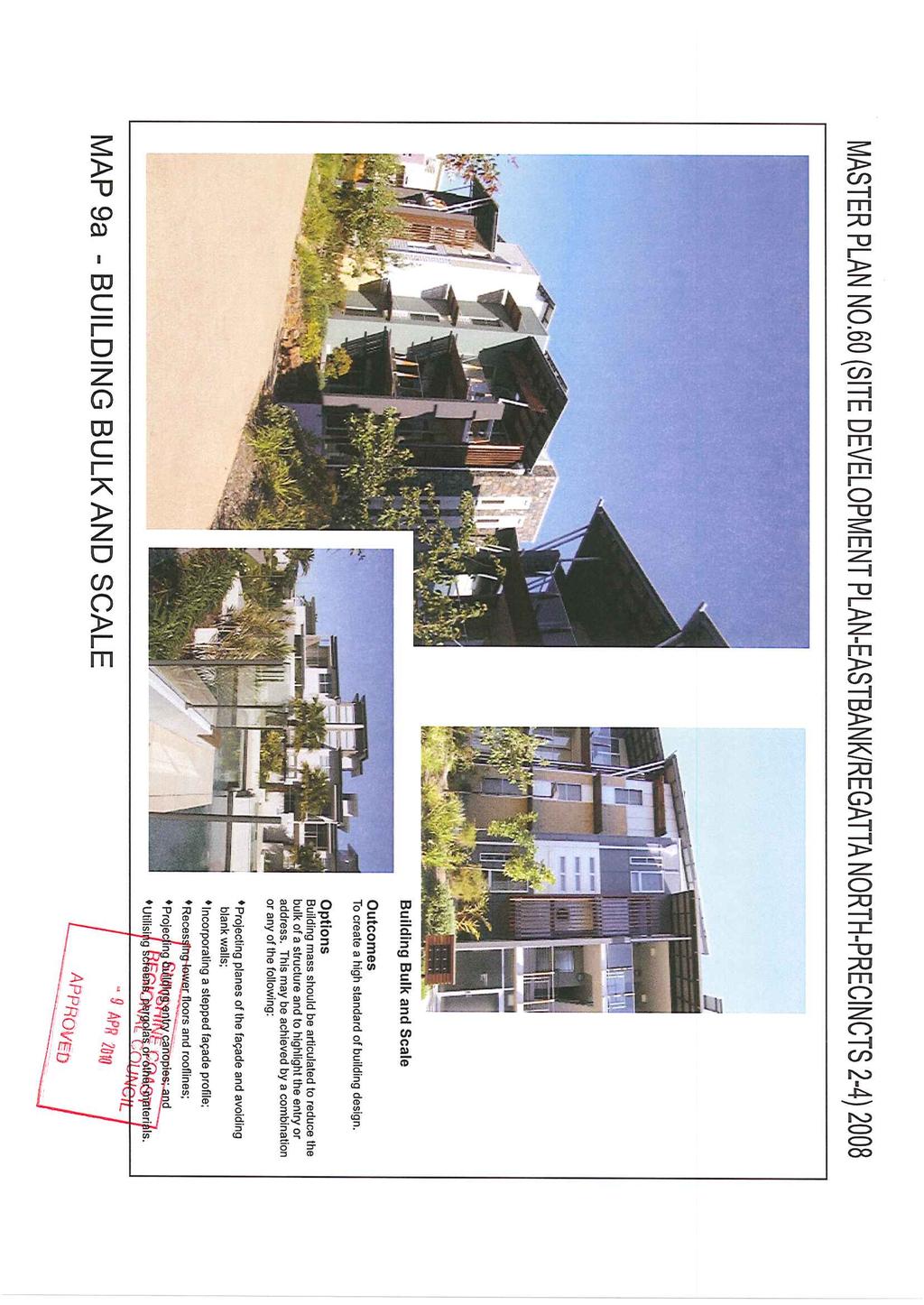
12 Page 12 widening and 2 indented bus set down areas along Lake Kawana Boulevard, in accordance with the requirements of item 1E.2 of Schedule 9 of the Infrastructure Agreement with respect to the Regional Hospital Land Vehicular access will be restricted to the points nominated on Map 6 Vehicular Movement Network Pedestrian / cyclist access to the site is made available from the surrounding network where appropriate, as per the indicative direct access points shown on Map 7 Pedestrian / Cyclist Movement Network Building Design and Appearance The following criteria should be complied with in relation to building design and appearance and should form part of a Material Change of Use application if appropriate. Other alternative or innovative solutions will be considered on their merit if it can be demonstrated that they can achieve a high standard of building design which fulfils the outcomes detailed in Section 7.3 of Master Plan No. 14 (Detailed Planning Area Plan Eastbank / Regatta North) 2001 and as demonstrated on Maps 9(a), 9(b), 9(c) and 9(d) of this Master Plan. The building design for the Column 1 use must also comply with the innovative intent expressed in Section 7.3 of Master Plan No. 14 (Detailed Planning Area Plan Eastbank / Regatta North) Building Setbacks Building setbacks for the perimeter of the development site are detailed on Map 4 (Site Development Plan) of this document and include the following provisions: In accordance with the Regional Hospital Infrastructure Agreement, a 4 metre wide strip along the full Lake Kawana Boulevard frontage of the site is expected to be required for road widening purposes as well as an indented bus set down area. As such, all building setbacks are to be based on this likely new boundary alignment. Buildings along Nicklin Way, Lake Kawana Boulevard and The Decks have a minimum 3m setback measured from the outer most projection (OMP) of the building. Building entry features are permitted
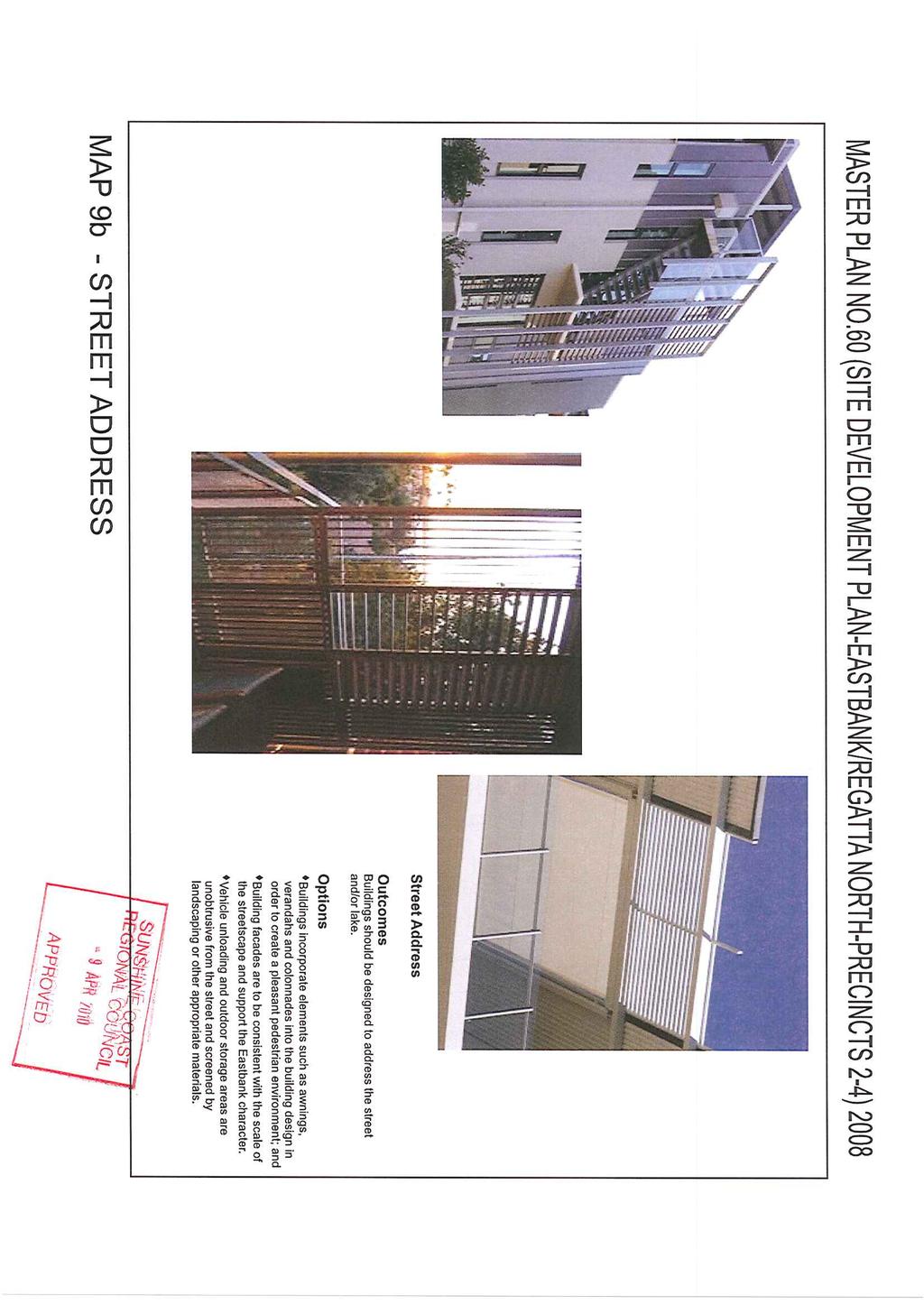
13 Page 13 to be located within the nominated 0-3m Transition Zone. The building elements should define points of entry and create an identity in terms of building design and appearance; Minimum front setback 3.0m to OMP; Side and rear boundary setbacks in accordance with Section 4.14(2)(b) of the Planning Scheme; Setback provisions exclude class 10 and landscape structures; The provisions of this section dealing with the setback requirements from Lake Kawana Boulevard as they relate to Lot 521 on SP may be varied, only with the consent of Council through a subsequent Material Change of Use application Building Bulk and Scale Details of building bulk and scale for the Site Development Plan should be provided as part of a Material Change of Use application for any building arising from Column 2 uses of Table 1 Supplementary Table of Development Precinct 2, 3 and 4 of this document. The Material Change of Use application should demonstrate the following: Street Address Building envelopes and siting should comply with the following:- Accommodation Building / Multiple Dwelling / Aged Person Home and Retirement Community must comply with the following: (i) Side and rear setbacks in Section 4.14(2)(b) of the Planning Scheme; and (ii) QRDG (Attached Housing, Element A2, Performance Criteria P2, P3, P4, P5 and P8) Attractive street address is achieved by the following:
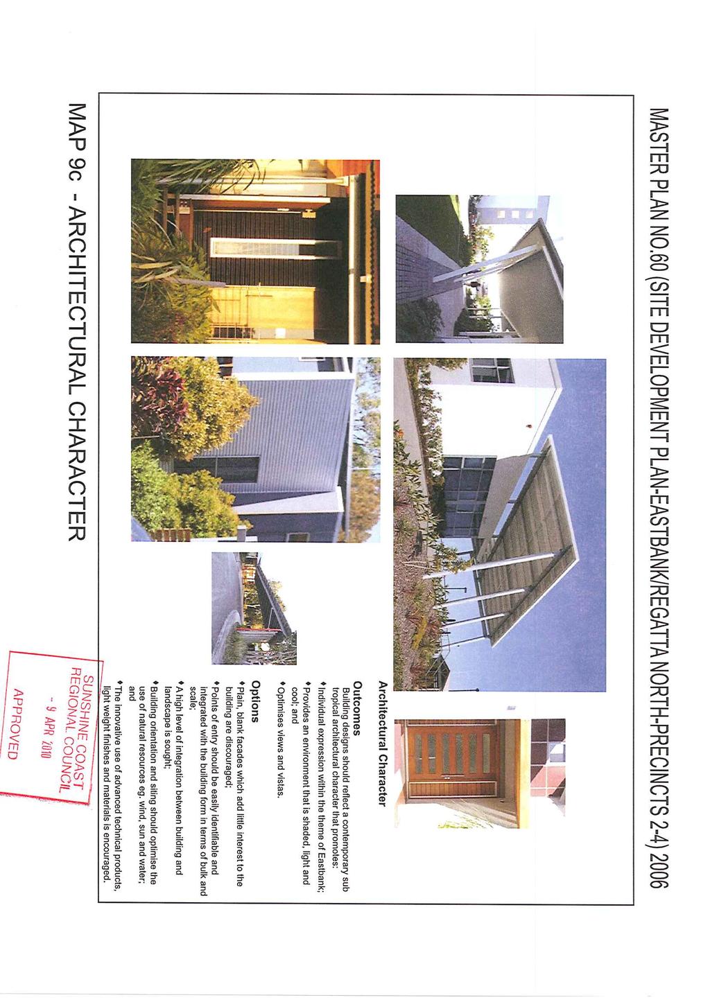
14 Page 14 Along the street frontages, building setbacks in accordance with Section and Map 4 of this Master Plan and the introduction of articulated features enhancing street presentation, in the transitional zone; Where a building has dual frontages to roads, the design of building facades should present to both frontages to provide an attractive street address ; Buildings that take up corner sites, are to be designed to address the street corner. Design features may include truncate corner to the building, roof forms, and/or parapets, to emphasis building form at street corner, and selected building materials, and finishes that offer a human scale; Vehicle unloading and outdoor storage areas are unobtrusive from the street and screened by landscaping or other appropriate materials; Along the street frontages, building setbacks in accordance with Section and Map 4 of this Master Plan and the introduction of articulated features enhancing street presentation in the transitional zone. Complying with QRDG (Attached Housing, Element B2, Performance Criteria P1, P3 & P9) Architectural Character Assessment of Architectural Character for the Site Development Plan should be undertaken as part of a Material Change of Use Application. The implementation of the Urban Design Performance Criteria under Section (Architectural Character) of Master Plan No. 14 (Detailed Planning Area Plan Eastbank / Regatta North) 2001 should reflect the following principles: Façade Treatment Façade elements should be broken down with feature elements such as external devices, integration of secondary materials, textures and colours, finishes, protrusions and penetrations;
15 Page 15 The innovative use of advanced technical products, finishes and materials is encouraged. Entry to buildings Entries to buildings should relate to their use (pedestrian/vehicular) in terms of scale and bulk: Provide a clear hierarchy of entrances for independent buildings; Provide generous, uncluttered, open transition space to main building entrances; Ensure the form of the entry statements are integrated into the form of their respective buildings; Ensure good visibility of entry statements from all pedestrian path approaches. Integration Between building and Landscaping The hard and soft elements of landscaping in courtyard areas should continue up to the building edge and, where applicable, into the building curtilage, e.g. ground cover material of the open space taken into verandah areas or under sun shading devices; Buildings or building elements may also come forward into the landscaping or the courtyard area with entry canopies or covered walks from public parking areas. Building Orientation and Siting The design of buildings should consider the following natural, functional and aesthetic opportunities presented by a site: Topography and how the building and car parks relate to the site; Vehicular and pedestrian access; Building siting in relation to access and adjoining development.
16 Page Energy Efficiency Building orientation to maximise aspect and views; Building orientation and use of landscape open space and public areas; Building orientation and siting to optimise the use of natural resources e.g. sun, wind, water; Building orientation and siting is to provide opportunities for dwelling units to maximise passive solar access and cross ventilation (especially through habitable rooms). Dwelling units are also designed to minimise the penetration of direct summer sun through the use of eaves, verandahs and shade devices incorporated into the building design to control sun entry to habitable rooms. All Material Change of Use applications are to include a comprehensive site analysis plan with a rationale for the building design and selected materials (such as high performance solar controlled glass) demonstrating that optimum use has been made of the passive measures for climate control to reduce reliance on mechanical heating and cooling devices. Building appearance and character should comply with the following:- QRDG (Attached Housing, Element B2, Performance Criteria P1, P3, & P9) Where applicable, the minimum standard for Energy Efficiency provisions as contained in the Building Code of Australia and the Queensland Development Code shall be achieved. Building designs are encouraged to exceed the Energy Efficiency provisions of the Building Code of Australia and the Queensland Development Code (details to be provided at Building Approval stage).
17 Page Landscape / Open Space Landscape Character Open Space design and landscaping for the land subject to this Site Development Plan shall contribute to the achievement of a high quality landscape character and incorporates the following elements: (a) (b) (c) (d) (e) (f) (g) (h) A minimum 3 metre wide landscape buffer strip (including fencing for privacy and acoustic purposes where appropriate) is provided along the frontage of Nicklin Way, Lake Kawana Boulevard and The Decks, excluding any driveways/access and building elements/entry features that extend into the 0-3 metre Transition Zone as illustrated on Map 4 Site Development Plan; A minimum 1.5 metre wide landscape buffer strip is provided on all site boundaries not having road frontage; Tree planting shall be provided to landscape frontages that will achieve a canopy spread over a minimum 50% of the site frontage to a minimum height of 10 metres; Landscaping is located to keep summer sunshine (particularly western sun) off walls, windows, roofs and paved external areas wherever possible; Landscaping allows access of winter sun to living areas, north facing windows and to public areas (including north-east winter morning sun); Scale of landscaping relative to the size and nature of the development and its setting; Landscaped areas along and/or near retaining walls, long unbroken walls, blank walls, service areas, car parking areas and recreational areas comprise a combination of trees, shrubs and groundcovers; Landscaping to create privacy between adjacent and overlooking dwellings; and
18 Page 18 (i) Landscaping to visually soften and screen any acoustic barriers/fences along road frontages and within the development. Complete landscaping details shall be provided with an application for Operational Works (Landscaping) Open Space Open space must comply with the following criteria:- - Open space to be provided at the following ratio per unit 1 bedroom (20m²), 2 bedrooms or greater (35m²) provided in accordance with Section 4.14(2)(d) of the Planning Scheme or the variation provisions contained in Section 4.14(4)(a)(ii) of the Planning Scheme; - Landscaping strips are to be provided in accordance with the following side and rear boundaries (1.5m wide) or in accordance with the variation provisions contained in Section 4.14(4)(a)(ii) of the Planning Scheme, front boundary (1.5m minimum width with an average of 2.0m, excluding the driveway) and does not contain a fence Open Space (where site developed for Aged Persons Home and/or Retirement Community) Private Open Space - Each ground floor independent dwelling unit is provided with a courtyard or similar private open space area and shall not be less than 20sqm with a minimum dimension of 3m directly accessible from the living area of the dwelling unit; - Each independent dwelling unit above ground level is provided with a balcony or similar private open space area and shall not be less than 10sqm with a minimum dimension of 2.5m directly accessible from the living area of the dwelling unit;
19 Page Lighting - Each ground floor hostel or nursing care unit is provided with a courtyard or similar private open space area and shall not be less than 10sqm with a minimum dimension of 2.5m directly accessible from the living area; and - Details pertaining to private open space areas shall be provided with a Material Change of Use application. Communal Open Space - A minimum area of 1000m 2 communal open space shall be provided on site in a maximum of 2 central locations (i.e. 2 areas at 500m 2 or 1 area at 1000m 2 ) with clear and defined access with minimum dimensions of 20 metres and exclusive of required buffers, setbacks, bio retention basins and infrastructure; - Communal open spaces are located in areas or an area that promotes and facilitates outdoor communal activities, accommodates visitors, provides access to direct sunlight and is sufficient size to enable outdoor recreation activities to be undertaken if desired; - Where located above ground level, communal open space for high care facilities (i.e. associated with hostel or nursing care units) shall be provided on each level and is of sufficient area to meet the needs of residents, visitors and staff; and - Details pertaining to the location of communal open space areas shall be provided with a Material Change of Use application Details of lighting design will be provided as part of an Operational Works Application, but should be in keeping with the Urban Design Performance Criteria in section of Master Plan No. 14 (Detailed Planning Area Plan Eastbank/Regatta North) 2001.
20 Page Estate Entry Points and Signage Details of signage will be provided as part of an Operational Works Application, but should be in keeping with the Urban Design Performance Criteria in section of Master Plan No. 14 (Detailed Planning Area Plan Eastbank/Regatta North) Estate Entry Points and Signage will be outlined within the landscape concept plan and will form part of the Material Change of Use application The location and details of minor entry points will be provided as part of an Operation Works Application Car Parking and Access Car parking should be provided in accordance with Part 3, Section 3.1 of the Planning Scheme for Caloundra City Council, or the conditions included in the Notice of Determination for Master Plan No. 60 where provided in accordance with section 6.1.2; Any relaxations to on site car parking requirements should be applied for at the Material Change of Use application stage or as agreed to by Council for Colum 1, permitted uses. The relaxations must be justified in accordance Council s Local Planning Policy PDLPP 3.1/01 - Parking and/or as justified to Council s satisfaction by a suitably qualified Traffic Engineer; The design of all car parking is to be provided in accordance with Council s Local Planning Policy PDLPP 3.1/01 - Parking, Section (Development Criteria Car parking) of Master Plan No. 14 (Detailed Planning Area Plan Eastbank/Regatta North) 2001, Urban Design Performance Criteria expressed in Section 7.5 (Car Parking and Access) of Master Plan No. 14 (Detailed Planning Area Plan Eastbank/Regatta North) 2001 and Section 10 (Access and Parking) of this Master Plan; Carparking and access is to be provided so that it is in a park-like setting, safe, visible, convenient and being of minimal visual impact on buildings and their immediate environment; Vehicular access to any development within Precinct 2, 3 and 4 will be limited to those points indicated on Map 6 Vehicular Movement Network, of this document;
21 Page On site car parking areas are to be screened from public view. Landscaping and architectural built form should be the predominant elements for all street frontages Movement Networks Vehicular Movement The Vehicular Movement Network, as identified on Map 6 of this Master Plan, demonstrates the following: Pedestrian/Cyclist Movement Proposed future road widening along Lake Kawana Boulevard and 2 indented bus set down areas in accordance with the requirements of item 1E.2 of Schedule 9 of the Infrastructure Agreement with respect to the Regional Hospital Land. Provision of a road hierarchy to carry traffic through efficiently, directly and safely, and the treatment of streets as parks through an incorporated landscaped streetscape network considering aesthetics and the amenity of adjacent land uses; Compliance with council standards regarding sufficient width of carriageway and verge allowing streets to perform their designated functions within the street network Pedestrian/Cyclist Movement Networks for the Site Development Plan are detailed on Map 7 (Pedestrian/Cyclist Movement Networks) of this document. This Pedestrian/Cyclist Movement Network demonstrates the following: Provision of pathways for pedestrian and cyclist movement providing connectivity with the surrounding locality. These include the footpaths alongside all streets; Provision of street tree planting and landscaping to all footpaths;
22 Page Public Transport Details of signage and hard/soft landscape structures will be provided as part of an operational works application Convenient, safe (in consideration of CPTED principles) and attractive access to public transport stops (where located nearby) is to be incorporated into any site and/or building design Acoustic Quality Residential Development (Precincts 2-4) Development should be designed with appropriate acoustic fencing and façade treatments to meet noise objectives which comply with AS2107 and AS3671; The location, design, construction and operation of development maintains suitable levels of amenity and environmental performance by not imposing unacceptable noise emissions/missions from: o Industrial Plant fixed or mobile; o Commercial Plan air conditioning, refrigeration, deliveries, waste storage and collection; or o Residential air conditioning. Relaxations to acoustics standards can occur where supported by a qualified Acoustic Consultant and where supported by Council.
23 Page Refuse Management Development must be designed with appropriate waste storage and recycling facilities that are conducive to the storage of waste in an environmentally acceptable and nuisance free manner; Waste storage facilities must be provided which are functionally appropriate for the users of the facility; Development must be designed so that the cleansing contractor can undertake waste collection services in a safe, efficient and unobstructed manner Stormwater Development must implement best practise stormwater management solutions to control stormwater water quality. Best practice stormwater management solutions shall be in accordance with Council's adopted stormwater management standards at the time when application for Material Change of Use is made. Sites should contain stormwater water quality devices such as retention tanks, bio-retention filters, infiltration beds or use other best practice solutions as the geotechnical environment permits, to treat stormwater before it leaves the site. Such best practice solutions are to be located in communal areas of the site and be the responsibility of the property owner at the time of further development and must be installed prior to the commencement of any use on the site Flood Management All building pad levels must be a suitable height above flood levels to protect the buildings from the risk of flooding during a combined ARI 100 year flood and storm surge event All access to building sites must be at an elevation that is safely accessible and trafficable during a combined ARI 100 year flood and storm surge event.
24 Page Sewerage Disposal Sewerage effluent from the site must be connected to Council's existing sewerage reticulation network, such that the network is utilised in the most efficient manner. To achieve this, the proportion of the site connected to the existing 300mm diameter trunk sewer downstream of Sewage Pumping Station RP1 must be maximised, in order to reduce the amount of pumping required for effluent from the site The existing sewerage infrastructure must be upgraded, where necessary, to the capacity required to service approved development within the catchment. Sewage Pumping Station RP1 in Stern Drive has been identified as requiring upgrade to service the catchment to Council s standards Subsequent development of the site must make a contribution to Council, to be used towards the upgrade of Sewage Pumping Station RP1, on the basis of the number of approved EPs discharging to Sewage Pumping Station RP1, as a proportion of the additional number of EPs required to be catered for as part of the upgrade. 12 IMPLEMENTATION OF SITE DEVELOPMENT PLAN DESIGN PARAMETERS 12.1 Requirement for a Site Development Plan A Site Development Plan is required under Section 9.1 of Master Plan No. 14 (Detailed Planning Area Plan Eastbank / Regatta North) Development within a Site Development Plan The land the subject of the Site Development Plan will be developed in accordance with DCP1 Section (b), the uses listed in Section 7.4 of the Structure Plan Development Criteria and Section 8 of Master Plan No.14 (Detailed Planning Area Plan - Eastbank / Regatta North) 2001.
25 Page Land uses within the Site Development Plan shall be restricted to those specified in the Table 1 and to the Development Criteria contained in Section of this document; All Development within the Site Development Plan shall be in accordance with Section 11, Implementation of Urban Design Performance Criteria, of this document Content of a Site Development Plan The content deemed appropriate for the Site Development Plan has been provided as follows: Lot Layout (refer Map 8 Dimensions Plan and Section 11.2 of this document); Building Setbacks (refer Map 4 Site Development Plan and Section of this document); Building Design and Appearance (as specified in Section 11.3 of this document); Parking and Access (refer Maps 6 Vehicular Movement Network, Map 4 - Site Development Plan and Section 11.5 of this document); Landscape/Open Space (as specified in Section 11.4 of this Document); Landscape Concepts (refer Maps 5(a), 5(b), 5(c) & 5(d) Landscape Concepts and Section 11.4 of this document);
26 Page MAPS AND TABLES This Site Development Plan comprises the following: Maps Tables (a) Map 1 Locality (b) Map 2 Land Subject of Master Plan (c) Map 3 Land Use Areas (d) Map 4 Site Development Plan (e) Map 5 Landscape Concept Plan (f) Map 6 Vehicular Movement Network (g) Map 7 Pedestrian/Cyclist Movement Network (h) Map 8 Dimensions Plan (i) Map 9(a) Building Bulk and Scale (j) Map 9(b) Street Address (k) Map 9(c) Architectural Character (l) Map 9(d) Building Setback and Landscape Interface (a) Table 1 - Supplementary Table of Development
27 Page STATEMENT OF COMPLIANCE 14.1 Requirements The Site Development Plan must comply with: (a) The Structure Plan; (b) Master Plan Determination No. 1 (Approval of Structure Plan) 1999; (c) The Planning Scheme including DCP 1; (d) Development Agreement; (e) Development Lease No. 2; (f) Master Plan No. 14 (Detailed Planning Area Plan Eastbank / Regatta North) 2001; (g) Infrastructure Agreement with respect to the Regional Hospital Land The Structure Plan The Site Development Plan complies with: (a) The Structure Plan Maps Master Plan Determination No. 1 (Approval of Structure Plan) The Site Development Plan complies with the Master Plan Determination No. 1 (Approval of Structure Plan) 1999 in that: it is consistent with the intent of the Urban Area as specified in Section 3.3 (Intent of the Urban Area) of the Structure Plan Development Criteria of Master Plan Determination No. 1 (Approval of Structure Plan) 1999;
28 Page it complies with the structure of the Urban Area as specified in section 3.4 (Structure of the Urban Area) of the Structure Plan Development Criteria of Master Plan Determination No. 1 (Approval of Structure Plan) 1999 as it applies to DPA 1; and it does not contain a development other than residential uses provided for in Section 3.4, Structure of the Urban Area, of the Structure Plan Development Criteria of Master Plan Determination No. 1 (Approval of Structure Plan) The Planning Scheme Including DCP The Site Development Plan complies with the Planning Scheme requirements including DCP 1 in that it complies with the provisions of section (Site Development Plan) of DCP Development Agreement The Site Development Plan complies with the requirements of the Development Agreement in that: it complies with the provisions of section 6 of the Development Agreement Development Lease No The Site Development Plan complies with the requirements of Development Lease No 2 in that: no part of this Site Development Plan is in conflict with any condition or requirement of Development Lease No 2; and the Development Agreement recognises that the leasehold land held under Development Lease No 2 is subject to the Master Plan Process as set out in sections (Development Lease No.2) and 7.4 (Preparation of Master Plan) of DCP 1.
29 Page Master Plan No. 14 (Detailed Planning Area Plan Eastbank / Regatta North) The Site Development Plan is consistent with the requirements of the Site Development Plan Design Parameters as specified in Section 8 and Urban Design Performance Criteria as Specified in Section 7 of Approved Master Plan No. 14 (Detailed Planning Area Plan Eastbank / Regatta North) Relaxations Relaxations may be sought for the following on this Site Development Plan: A relaxation of parking requirements may be sought at the Material Change of Use Application A relaxation of building setbacks and landscape setbacks may be sought where it can be demonstrated that a reduced setback does not adversely impact on any adjoining or adjacent property and the streetscape. Such relaxations are to be applied for with the Material Change of Use application. 15 INTERPRETATION RULES 15.1 Terms used in this Site Development Plan have the meaning given in Part 8 (Meaning of Words and Interpretation) of the Caloundra City Council Planning Scheme unless otherwise defined in this Site Development Plan; 15.2 Interpretation of words on terms used in this Site Development Plan are to be interpreted in accordance with Part 8.3 (Interpretation) of the Caloundra City Council Planning Scheme unless the context otherwise indicates or requires.
30 Page SUPPORTING INFORMATION 16.1 Supporting Information is provided in the form of the following reports:- A Detailed Acoustic Report should be provided in association with any use proposed in a Material Change of Use application (if appropriate) arising out of any requirement of this Master Plan, or where the use is a permitted use not requiring a Material Change of Use application, in association with a Building Approval application, if appropriate, or if not provided as part of this Master Plan.
31 Page TABLE 1: SUPPLEMENTARY TABLE OF DEVELOPMENT PRECINCTS 2-4 PRECINCT Precinct 2 COLUMN 1 PERMITTED USES Park Public Purpose COLUMN 2 PERMITTED SUBJECT TO CONDITIONS Aged Persons Home Cluster Development COLUMN 3 CONSENT REQUIRED COLUMN 1 PROHIBITED USES Uses not listed in Columns 1, 2 and 3 Public Utility excluding Telecommunications facility Display Home Home Occupation Retirement Community Sport and Recreation (Bowls Club)
32 Page 32 PRECINCT Precinct 3 COLUMN 1 PERMITTED USES Car Park (temporary) Park COLUMN 2 PERMITTED SUBJECT TO CONDITIONS Aged Persons Home Cluster Development COLUMN 3 CONSENT REQUIRED COLUMN 1 PROHIBITED USES Uses not listed in Columns 1, 2 and 3 Public Purpose Display Home Public Utility (excluding Telecommunications Facility) Home Occupation Retirement Community Temporary House and Land Sales Office
33 Page 33 PRECINCT Precinct 4 COLUMN 1 PERMITTED USES Car Park (temporary) Park COLUMN 2 PERMITTED SUBJECT TO CONDITIONS Accommodation Building Aged Persons Home COLUMN 3 CONSENT REQUIRED COLUMN 1 PROHIBITED USES Uses not listed in Columns 1, 2 and 3 Public Purpose Cluster Development Public Utility excluding Telecommunications facility Display Home Educational Establishment Health Care Premises Home Occupation Multiple Dwelling Retirement Community Temporary House and Land Sales Office
34
35
36
37
38
39

40
41
42
43
44
45
MASTER PLAN NO. 62 (SITE DEVELOPMENT PLAN BIRTINYA VILLAGE CENTRE) 2009
 2009") Development Agreement, Development Control Plan 1 - Kawana Waters and Section 6.1.45A (Development Control Plans under Repealed Act) of the Integrated Planning Act 1997 MASTER PLAN NO. 62 (SITE DEVELOPMENT
Development Agreement, Development Control Plan 1 - Kawana Waters and Section 6.1.45A (Development Control Plans under Repealed Act) of the Integrated Planning Act 1997 MASTER PLAN NO. 62 (SITE DEVELOPMENT
MASTER PLAN N0. 76 (SITE DEVELOPMENT PLAN DETAILED PLANNING AREA 12 PRECINCT 13) 2013
 2013") MASTER PLAN N0. 76 (SITE DEVELOPMENT PLAN DETAILED PLANNING AREA 12 PRECINCT 13) 2013 TABLE OF CONTENTS 1.0 ADMINISTRATION... 5 1.1 Preliminary... 5 1.2 Location and Description... 6 1.3 Zoning Map Description...
MASTER PLAN N0. 76 (SITE DEVELOPMENT PLAN DETAILED PLANNING AREA 12 PRECINCT 13) 2013 TABLE OF CONTENTS 1.0 ADMINISTRATION... 5 1.1 Preliminary... 5 1.2 Location and Description... 6 1.3 Zoning Map Description...
MASTER PLAN NO. 40 (SITE DEVELOPMENT PLAN BIRTINYA LAND USE AREA RESIDENTIAL 1) 2007 TABLE OF CONTENTS
 2007 TABLE OF CONTENTS") MASTER PLAN NO. 40 (SITE DEVELOPMENT PLAN BIRTINYA LAND USE AREA RESIDENTIAL 1) 2007 TABLE OF CONTENTS PAGE 1.0 PRELIMINARY 1.1 Citation 1 1.2 Type of Master Plan 1 1.3 Legal Requirement for Master Plan
MASTER PLAN NO. 40 (SITE DEVELOPMENT PLAN BIRTINYA LAND USE AREA RESIDENTIAL 1) 2007 TABLE OF CONTENTS PAGE 1.0 PRELIMINARY 1.1 Citation 1 1.2 Type of Master Plan 1 1.3 Legal Requirement for Master Plan
Development Control Plan
 Development Control Plan Liberty Grove Development Control Plan Date of Adoption: 4 September 2007 Effective Date: 7 March 2008 Index 1 INTRODUCTION... 3 1.1 NAME OF PLAN... 3 1.2 AREA TO WHICH THIS PLAN
4 Residential and Urban Living Zones
 4 Residential and Urban Living Zones Refer to Chapters 11 to 20 for additional rules that may apply to these zones. 4.1 OBJECTIVES AND POLICIES Objective Res1 Policy 1 Policy 2 Policy 3 Policy 4 Policy
Part 9 Specific Land Uses - Housing on Small and Narrow Lots
 19 HOUSING ON SMALL AND NARROW LOTS This section of the DCP applies where development for the purpose of a dwelling house, attached dwellings, or semi-detached dwellings is or are proposed in the R2 Low
Section Three, Appendix 16C Medium Density Housing, Design Assessment Criteria (Residential 8A zone)
") APPENDIX 16C MEDIUM DENSITY HOUSING, DESIGN ASSESSMENT CRITERIA (RESIDENTIAL 8A ZONE) PURPOSE OF APPENDIX 16C (RESIDENTIAL 8A ZONE) In the Residential 8A Zone the following are defined as restricted discretionary
APPENDIX 16C MEDIUM DENSITY HOUSING, DESIGN ASSESSMENT CRITERIA (RESIDENTIAL 8A ZONE) PURPOSE OF APPENDIX 16C (RESIDENTIAL 8A ZONE) In the Residential 8A Zone the following are defined as restricted discretionary
Subdivision Design Criteria. Penihana North GUIDELINES TO THE RULES
 Created September 2013 Penihana North Subdivision Design Criteria GUIDELINES TO THE RULES This part of the Plan sets out the design criteria for subdivision in Penihana North. The criteria will be considered
I539. Smales 2 Precinct
 I539. Smales 2 Precinct I539.1. Precinct Description The Smales 2 Precinct applies to a 4.8 hectare block of land located on the southern side of Northcote Road and fronting Lake Pupuke, Takapuna. The
I615. Westgate Precinct
 I615. Westgate Precinct I615.1. Precinct Description The Westgate Precinct is located approximately 18km west of the Auckland city centre. There are seven Sub-precincts in the Westgate Precinct: Sub-precinct
Chapter 13 Residential Areas: Appendices APPENDIX 1 Residential Areas
 Chapter 13 Residential Areas: Appendices Page 1 Chapter 13 Residential Areas: Appendices APPENDIX 1 Residential Areas Design Code for Intensive Housing INTRODUCTION DESIGN ELEMENTS A NEIGHBOURHOOD DESIGN
Cape Cabarita (Formerly known as the Wellcome Site) Development Control Plan. Date of Adoption: 4 September 2007 Effective Date: 7 March 2008
 Development Control Plan. Date of Adoption: 4 September 2007 Effective Date: 7 March 2008") Cape Cabarita (Formerly known as the Wellcome Site) Development Control Plan Date of Adoption: 4 September 2007 Effective Date: 7 March 2008 Development Control Plan Index 1 INTRODUCTION...3 1.1 LAND TO
Cape Cabarita (Formerly known as the Wellcome Site) Development Control Plan Date of Adoption: 4 September 2007 Effective Date: 7 March 2008 Development Control Plan Index 1 INTRODUCTION...3 1.1 LAND TO
Division 13 Local Business and Industry Buffer Zone: Assessment Criteria and Assessment Tables
 Division 13 Local Business and Industry Buffer Zone: Assessment Criteria and Assessment Tables 4.13.1 Local Business and Industry Buffer Zone The provisions in this division relate to the Local Business
Section Three, Appendix 17C Multiple Unit Housing Design Assessment Criteria
 APPENDIX 17C MULTIPLE UNIT HOUSING DESIGN ASSESSMENT CRITERIA Purpose of Appendix 17C In the Residential 9 Zone the construction and use of multiple household units located within the Multiple Household
medium desnity housing
 This section updated September 2013 This part of the Plan sets out the assessment criteria for medium density housing. The criteria are designed to give designers and builders flexibility and to provide
22.15 OUTDOOR ADVERTISING SIGNAGE POLICY
 22.15 OUTDOOR ADVERTISING SIGNAGE POLICY This policy applies to all land where a planning permit is required to construct or display a sign under the provisions of the Kingston Planning Scheme. 22.15-1
H9. Business Metropolitan Centre Zone
 H9. Business Metropolitan Centre Zone H9.1. Zone description The Business Metropolitan Centre Zone applies to centres located in different subregional catchments of Auckland. These centres are second only
open space environment
 This section updated August 09 GUIDELINE TO THE RULES The Open Space Environment Rules apply to activities on sites within the Open Space Environment as shown on the Human Environments Maps. Most of the
City of Vaughan Urban Design Guidelines for Infill Development in Established Low-Rise Residential Neighbourhoods
 City of Vaughan Urban Design Guidelines for Infill Development in Established Low-Rise Residential Neighbourhoods DRAFT - September 2016 Contents 1. Introduction 1 2. Policy Context 3 3. Characteristics
SCHEDULE 12 TO THE DESIGN AND DEVELOPMENT OVERLAY GLEN WAVERLEY ACTIVITY CENTRE STRUCTURE PLAN
 DD/MM/YY Proposed C120 SCHEDULE 12 TO THE DESIGN AND DEVELOPMENT OVERLAY Shown on the planning scheme map as DDO12. GLEN WAVERLEY ACTIVITY CENTRE STRUCTURE PLAN 1.0 Design objectives DD/MM/YY Proposed
THREE PARKS ZONE Three Parks Special Zone The process of applying for resource consents in the zone.
 .25 Three Parks Special Zone The purpose of this zone is to provide for growth and to give effect to the Wanaka 2020 Community (2002) and the more recent Wanaka Structure (2007) and Wanaka Transport Strategy
11.3 SPECIAL CHARACTER ZONE HAWKE S BAY REGIONAL SPORTS PARK
 11.3 SPECIAL CHARACTER ZONE HAWKE S BAY REGIONAL SPORTS PARK 11.3.1 INTRODUCTION The availability of sports and recreation activities and facilities is important for the maintenance and enhancement of
I609. Penihana North Precinct
 I609. Penihana North Precinct I609.1. Precinct description The Penihana North Precinct is located south of the Swanson Railway Station, adjacent to the Rural Urban Boundary (RUB) and Waitakere Ranges Heritage
RESIDENTIAL ACTIVITY PERFORMANCE STANDARDS
 Preferred Options Consultation Q&A Sheet RESIDENTIAL ACTIVITY PERFORMANCE STANDARDS What are the key goals for managing the design of residential buildings in the Second Generation Plan (2GP)? The key
AOTEA SUPERMARKET ZONE. Zone Introduction
 C18 AOTEA SUPERMARKET ZONE Zone Introduction C18.1 Objective This zone identifies a specific area in Aotea for a stand alone supermarket. The zone is site specific and has a range of objectives, policies
7.2.9 Eudlo local plan code
 7.2.9 local plan code 7.2.9.1 Application (1) This code applies to assessable development:- (a) within the local plan area as shown on Map ZM29 contained within Schedule 2 (Mapping); and (b) identified
Keystone Business Park Precinct Structure Plan North East Industrial Precinct. Part 2 Design Principles
 Keystone Business Park Precinct Structure Plan North East Industrial Precinct Part 2 Design Principles Context Issues Services Landform Issues Geotech and contamination Ecology Traffic and access Issues
Division 7 Character Areas Housing Zone: Assessment Criteria and Assessment Tables
 Division 7 Character Areas Housing Zone: Assessment Criteria and Assessment Tables 4.7.1 Character Areas Housing Zone The provisions in this division relate to the Character Areas Housing Zone as follows
APPENDIX MATAKANA COMMERCIAL URBAN DESIGN GUIDELINES
 APPENDIX MATAKANA COMMERCIAL URBAN DESIGN GUIDELINES 1.0 INTRODUCTION The following urban design guidelines are to be utilised by landowners, planners and other persons involved in development at early
APPENDIX 10 THE RESIDENTIAL DESIGN GUIDE FOR DEVELOPMENTS IN RESIDENTIAL ZONES IN SPECIFIED GROWTH AREAS
 THE RESIDENTIAL DESIGN GUIDE FOR DEVELOPMENTS IN RESIDENTIAL ZONES IN SPECIFIED GROWTH AREAS ISTHMUS SECTION - OPERATIVE 1999 Page 1 CONTENTS... PAGE 1.0 INTRODUCTION... 4 1.1 Growth Management Strategy...
Wide asphalt driveway abutting school property. garage built with incompatible materials, too close to park. incompatible fencing materials
 Wide asphalt driveway abutting school property incompatible fencing materials garage built with incompatible materials, too close to park Lack of plantings as a buffer between private property and open
H10. Business Town Centre Zone
 H10. Business Town Centre Zone H10.1. Zone description The Business Town Centre Zone applies to suburban centres throughout Auckland, the satellite centres of Warkworth and Pukekohe, and the rural towns
H14. Business General Business Zone
 H14. Business General Business Zone H14.1. Zone description The Business General Business Zone provides for business activities from light industrial to limited office, large format retail and trade suppliers.
Memorial Business Park Site. Proposed Future Development. Design guidelines. August
 Memorial Business Park Site Proposed Future Development Design guidelines August 2014 www.designenvironment.co.nz 0064 3 358 3040 Contents 1.0 Background 1.1 Introduction 3 1.2 Objectives 4 2.0 Context
H13. Business Mixed Use Zone
 H13. Business Mixed Use Zone H13.1. Zone description The Business Mixed Use Zone is typically located around centres and along corridors served by public transport. It acts as a transition area, in terms
CHAPTER 13 DESIGN GUIDELINES
 CHAPTER 13 DESIGN GUIDELINES Section 1300.00 Section 1300.01 Design Guidelines Purpose The purposes of this section are to: A. The purpose of this Section is to establish procedures and standards to serve
6.6.2 Emerging Community Zone Code Application Purpose and overall outcomes. s6 Zone Codes Emerging Community and Township Zone Codes
 6.6.2 Emerging Community Zone Code 6.6.2.1 Application This code applies to assessable development:- (1) within the Emerging Community Zone as identified on the zoning maps contained within Schedule 2
I404 Beachlands 2 Precinct
 I404. Beachlands 2 I404.1. Precinct Description The Beachlands 2 precinct covers approximately 6 hectares of land at the corner of Beachlands and Whitford Maraetai Roads. Its purpose is to provide for
Highland Village Green Design Guidelines
 Highland Village Green Design Guidelines Publishing Information Title Highland Village Green Design Guidelins Author The City of Calgary Status DRAFT - Proposed document subject to changes Additional Copies
East Bayshore Road Neighbourhood
 East Bayshore Road Neighbourhood Northridge Property Management Urban Design Brief 3195 East Bayshore Road City of Owen Sound January 2016 East Bayshore Road Neighbourhood Northridge Property Management
GREENVALE CENTRAL PRECINCT STRUCTURE PLAN
 76 Conservation area boundary. Low Fence to exclude vehicles but allow pedestrian access Front boundary of allotment 5.0m MINIMUM SETBACK Path providing public access to dwellings fronting Conservation
WELLINGTON HOSPITAL DESIGN GUIDE TABLE OF CONTENTS
 WELLINGTON HOSPITAL DESIGN GUIDE TABLE OF CONTENTS 1.0 Introduction Page 2 The Place of Wellington Hospital 2 The Future of the Hospital 2 2.0 The Intention of the Design Guide 3 3.0 Analysis 4 General
6.0 Land Use Policies for Rural Settlements. 6.1 Rural Settlement Strategy
 6.0 Land Use Policies for Rural Settlements 6.1 Rural Settlement Strategy INTRODUCTION AMENDMENT NO. 131 PURPOSE Designated rural settlements comprise Rural Clusters, Villages and Serviced Villages as
Nelson Residential Street Frontage Guideline
 DRAFT 22-06-2012 Nelson Residential Street Frontage Guideline June 2012 1317273 Contents and purpose Residential s are important Residential s are much more than corridors which move traffic. Streets allow
Ensure that development within the Arrowtown Urban Growth Boundary provides:
 URBAN DEVELOPMENT 4 4.2.5.2 Ensure that development within the Arrowtown Urban Growth Boundary provides: an urban form that is sympathetic to the character of Arrowtown, including its scale, density, layout
Duplex Design Guidelines
 Duplex Design Guidelines Adopted by Council May 29, 2006 Prepared By: Table of Contents 1.0 Application and Intent 1 2.0 Areas of Application 2 3.0 Design Principles 3 4.0 Design Guidelines 4 4.1 Site
Housing Development at Balloonagh Tralee Co Kerry
 Design Statement Housing Development at Balloonagh Tralee Co Kerry Area of site 10,400m2 24 houses-12no 3 bed, 12no 2 bed and 4 single bed apartments total residential area of 2411m2 Open space provided
Design Guide: - Residential Centres
 Design Guide: - Residential Centres Introduction Hamilton City Council wishes to take a stronger and more visionary role in guiding the future development of Hamilton s built environment to ensure that
Draft Ada Street Cardiff Area Plan
 Draft Ada Street Cardiff Area Plan (Draft Amendment to Lake Macquarie Development Control Plan 2014) Exhibition: The draft Area Plan is on public exhibition from 29 February 2016 to 29 March 2016. Submissions:
I403 Beachlands 1 Precinct
 I403. Beachlands 1 I403.1. Precinct Description Beachlands is a rural and coastal village located on the eastern side of Auckland, adjoining the Tamaki Strait coastline. The original Beachlands village
AMENDMENTS. Date Effective. Amendment No. Council. DCP 14 Davidson St, Greenacre Page 2
 AMENDMENTS Amendment No. Description Adopted by Council Date Effective DCP 14 Davidson St, Greenacre Page 2 TABLE OF CONTENTS 1.0 INTRODUCTION... 4 1.1 NAME OF THIS PLAN... 4 1.2 COMMENCEMENT OF DEVELOPMENT
Development Control Plan
 Development Control Plan Abbotsford Cove (Also known as the Former Nestle Site) Development Control Plan Date of Adoption: 4 September 2007 Effective Date: 7 March 2008 Index 1 INTRODUCTION... 3 1.1 ENVIRONMENTAL
Sawtell Town Centre Development Control Plan
 Sawtell Town Centre Development Control Plan ABN 79 126 214 487 CONTENTS INTRODUCTION... 1 PREAMBLE... 1 HOW TO USE THIS DCP... 1 LAND TO WHICH THIS PLAN APPLIES... 1 MASTERPLAN... 2 VISION... 2 CHARACTER
1. Assessment of Environmental Effects
 1. Assessment of Environmental Effects Table of Contents 1. Introduction and Overview 1 2. Statutory Assessment 3 3. Site Description 5 4. Proposal Description 7 5. Assessment of Effects on the Environment
Chapter 2: OUTLINE PLANNING APPLICATION PROPOSALS. A New Garden Neighbourhood Matford Barton 17
 Chapter 2: OUTLINE PLANNING APPLICATION PROPOSALS A New Garden Neighbourhood Matford Barton 17 2.1. SUMMARY AND STATUS OF THE PROPOSALS 2.1.1. The parameter plans and associated wording in this chapter
Contents of Part 6. Part 6 Zones
 Contents of Part 6 Part 6 Zones... 6-1 6.1 Preliminary... 6-1 6.2 Zone codes... 6-3 6.2.1 Low density residential zone code... 6-3 6.2.1.1 Application... 6-3 6.2.1.2 Purpose and overall outcomes... 6-3
REMARKABLES PARK ZONE
 .10 Remarkables Park Zone.10.1 Resources, Activities and Values The Remarkables Park Area comprises approximately 150 hectares of perimeter urban land in the vicinity of Frankton and occupies a strategic
NORTH EAST INDUSTRIAL ZONE
 SECTION 12A: NORTH EAST INDUSTRIAL ZONE CONTENTS 12A.1 Introduction 1 12A.2 Resource Management Issues 2 12A.3 Objectives and Policies 3 12A.4 Rules: Permitted Activities 8 R12A.4.1 Permitted Activities
FRUITVALE TRANSIT VILLAGE (Phase 2) Residential Project
 Residential Project") FRUITVALE TRANSIT VILLAGE (Phase 2) Residential Project DEVELOPER: SIGNATURE PROPERTIES ARCHITECT: HKIT ARCHITECTS April 23, 2010 TABLE OF CONTENTS 3 Vision 4 Description of Site 5 Guiding Concepts 6
FRUITVALE TRANSIT VILLAGE (Phase 2) Residential Project DEVELOPER: SIGNATURE PROPERTIES ARCHITECT: HKIT ARCHITECTS April 23, 2010 TABLE OF CONTENTS 3 Vision 4 Description of Site 5 Guiding Concepts 6
LITHGOW CITY COUNCIL DEVELOPMENT CONTROL PLAN ADI LIMITED SITE LITHGOW SMALL ARMS FACTORY METHVEN STREET, LITHGOW
 LITHGOW CITY COUNCIL DEVELOPMENT CONTROL PLAN ADI LIMITED SITE LITHGOW SMALL ARMS FACTORY METHVEN STREET, LITHGOW 6 November 2003 CONTENTS Page 1. INTRODUCTION 1.1 Purpose 1 1.2 Citation 1 1.3 Adoption
FORMER CANADIAN FORCES BASE (CFB) ROCKCLIFFE SECONDARY PLAN. Official Plan Amendment XX to the Official Plan for the City of Ottawa
 ROCKCLIFFE SECONDARY PLAN. Official Plan Amendment XX to the Official Plan for the City of Ottawa") FORMER CANADIAN FORCES BASE (CFB) ROCKCLIFFE SECONDARY PLAN Official Plan Amendment XX to the Official Plan for the City of Ottawa 1 INDEX THE STATEMENT OF COMPONENTS PART A THE PREAMBLE PAGE Purpose...
FORMER CANADIAN FORCES BASE (CFB) ROCKCLIFFE SECONDARY PLAN Official Plan Amendment XX to the Official Plan for the City of Ottawa 1 INDEX THE STATEMENT OF COMPONENTS PART A THE PREAMBLE PAGE Purpose...
B L A C K D I A M O N D D E S I G N G U I D E L I N E S for Multi-family Development
 B L A C K D I A M O N D D E S I G N G U I D E L I N E S for Multi-family Development Adopted June 18, 2009 This section of the Design and focuses on site planning and design guidance for new multi-family
Division 6 Residential Code
 Division 6 Residential Code 12.6.1 Residential Code The provisions in this division comprise the Residential Code. They are compliance with the Residential Code (section 12.6.2); overall outcomes for the
PART AOTEA PRECINCT
 CONTENTS... PAGE AOTEA PRECINCT...4 14.5.1 INTRODUCTION...4 14.5.2 RESOURCE MANAGEMENT ISSUES...4 14.5.3 RESOURCE MANAGEMENT OBJECTIVES AND POLICIES... 4 14.5.4 RESOURCE MANAGEMENT STRATEGY...5 14.5.5
Gulf Harbour Non-Regulatory Design Guidelines. For Golf Residential Developments Including Integrated Residential Developments
 Design Guidelines For Golf Residential Developments Including Integrated Residential Developments Table of Contents Page 1 Introduction. 02 2 Structure of Guidelines.... 03 3 Non-Regulatory Design Guidelines
Division 5 Reconfiguring a Lot Code
 Division 5 Reconfiguring a Lot Code 12.5.1 Reconfiguring a Lot Code The provisions in this division comprise the Reconfiguring a Lot Code. They are compliance with the Reconfiguring a Lot Code (section
Rural (Urban Expansion) Environment
 Environment") RUEE.1 Rural (Urban Expansion) Environment Index RUEE.1 RUEE.1.1 RUEE.1.2 RUEE.1.3 RUEE.1.4 RUEE.2 RUEE.2.1 RUEE.2.2 RUEE.2.3 RUEE.2.4 RUEE.3 Rural (Urban Expansion) Environment Description and Expectations
RUEE.1 Rural (Urban Expansion) Environment Index RUEE.1 RUEE.1.1 RUEE.1.2 RUEE.1.3 RUEE.1.4 RUEE.2 RUEE.2.1 RUEE.2.2 RUEE.2.3 RUEE.2.4 RUEE.3 Rural (Urban Expansion) Environment Description and Expectations
Development Control Plan
 Development Control Plan Rhodes Corporate Park (Also known as the Digital Site) Development Control Plan Date of Adoption: 4 September 2007 Effective Date: 7 March 2008 Index 1 INTRODUCTION... 3 1.1 LAND
FRASER LANDS CD-1 GUIDELINES (BLOCKS 68 AND 69) Adopted by City Council April 1989
 Adopted by City Council April 1989") $1 City of Vancouver Land Use and Development Policies and Guidelines Community Services, 453 W. 12th Ave Vancouver, BC V5Y 1V4 F 604.873.7344 fax 873.7060 planning@city.vancouver.bc.ca FRASER LANDS CD-1
$1 City of Vancouver Land Use and Development Policies and Guidelines Community Services, 453 W. 12th Ave Vancouver, BC V5Y 1V4 F 604.873.7344 fax 873.7060 planning@city.vancouver.bc.ca FRASER LANDS CD-1
SECTION 7A: WHAKARONGO RESIDENTIAL AREA
 SECTION 7A: WHAKARONGO RESIDENTIAL AREA CONTENTS 7A.1 Introduction 1 7A.2 Resource Management Issues 1 7A.3 Objectives and Policies 1 7A.4 Methods 4 7A.5 Residential Zone 4 7A.5.1 Rules: Controlled Activities
BYLAW C A Bylaw of Rocky View County to amend Land Use Bylaw C
 BYLAW C-7720-2017 A Bylaw of Rocky View County to amend Land Use Bylaw C-4841-97. The Council of Rocky View County enacts as follows: PART 1 TITLE This Bylaw shall be known as Bylaw C-7720-2017. PART 2
Next Steps / Development Process. Structure Plan. June submitted to City of Fremantle. Structure Plan. July supported for advertising
 overview What is today about? In July 0, the City of Fremantle resolved that the be advertised for public comment. Today is about: Understanding the history and context of the site Having your say on the
Rochedale Urban Community Local Plan
 Rochedale Urban Community Local Plan 1. Introduction This Local Plan contains specific additional local planning requirements. Where it conflicts with the requirements of the City Plan, this Local Plan
GREENBANK DEVELOPMENT MASTERPLAN
 DEVELOPMENT MASTERPLAN POTENTIAL TRAIN STATION COMMUNITY CENTRE Greenbank will be a connected masterplanned community providing easy access to local and surrounding amenity. Affordable quality homes, green
ARTICLE 6: Special and Planned Development Districts
 ARTICLE 6: Special and Planned Development Districts 6-10 Traditional Neighborhood Development (TND) District 6-10.10 Purpose and Intent The Traditional Neighborhood Development (TND) District provides
North Oakville East Parks Facilities Distribution Plan. November, 2009
 North Oakville East November, 2009 POLICY CONTEXT 1) Purpose a) The purpose of this document is to be a guide for the location, configuration, design and development of the parks system for the North Oakville
97 Lea Bridge Road, Leyton, E10 7QL London Borough of Waltham Forest December 2015
 97 Lea Bridge Road, Leyton, E10 7QL London Borough of Waltham Forest December 2015 Public Realm and Landscape Proposals LEA BRIDGE ROAD, WALTHAMSTOW Public Realm & Landscape Proposals BDP(90)RPT001 December
I331. St John s Theological College Precinct
 I331. St John s Theological College Precinct I331.1. Precinct Description The precinct contains the existing St John s Theological College which is a residential college for the Anglican Church in New
(DC1) Direct Development Control Provision DC1 Area 4
 Direct Development Control Provision DC1 Area 4") . General Purpose (DC) Direct Development Control Provision DC Area 4 The purpose of this Provision is to provide for an area of commercial office employment and residential development in support of the
. General Purpose (DC) Direct Development Control Provision DC Area 4 The purpose of this Provision is to provide for an area of commercial office employment and residential development in support of the
SCHEDULE THREE TO THE DEVELOPMENT PLAN OVERLAY EASTERN GOLF COURSE KEY REDEVELOPMENT SITE
 DD/MM/YY SCHEDULE THREE TO THE DEVELOPMENT PLAN OVERLAY Shown on the planning scheme map as DPO3 EASTERN GOLF COURSE KEY REDEVELOPMENT SITE 1.0 A permit may be granted before a development plan has been
Intentional blank page
 Intentional blank page Intentional blank page Contents 1.0 INTRODUCTION... 1 1.1 Name... 1 1.2 Date of Adoption... 1 1.3 Aim... 1 1.4 Land to Which This Plan Applies... 1 1.5 Relationship to Other Plans,
Section Three, Part 16 Takanini Structure Plan Area
 PART 16 TAKANINI STRUCTURE PLAN AREA 16.1 Residential 8 zone 16.1.1 Objectives and Policies 16.1.2 Rules: General 16.1.3 Rules: Activity Status Subdivision (Except within the Addison Neighbourhood Centre)
Design and siting guidelines
 Design and siting guidelines Enhance your lifestyle Callaway Park an development 1 These Guidelines deal with the planning and development of the vacant residential land lots at Callaway Park. 2 Introduction
H7 Open Space zones. (a) provide for the needs of the wider community as well as the needs of the community in which they are located;
 provide for the needs of the wider community as well as the needs of the community in which they are located;") H7. Open Space zones H7.1. Background The majority of land zoned as open space is vested in the Council or is owned by the Crown. However some areas zoned open space are privately owned. While the open
H7. Open Space zones H7.1. Background The majority of land zoned as open space is vested in the Council or is owned by the Crown. However some areas zoned open space are privately owned. While the open
URBAN DESIGN BRIEF URBAN DESIGN BRIEF 721 FRANKLIN BLVD, CAMBRIDGE August 2018
 URBAN DESIGN BRIEF URBAN DESIGN BRIEF 721 FRANKLIN BLVD, CAMBRIDGE August 2018 DESIGN BRIEF CONTENTS PART A 1.0 INTRODUCTION 2.0 DESCRIPTION & ANALYSIS OF SITE CONTEXT 3.0 DESIGN CONSTRAINTS AND OPPORTUNITIES
I602. Birdwood Precinct
 I602. Birdwood Precinct I602.1. Precinct description The Birdwood Precinct applies to an area west of Don Buck Road and south of Red Hills Road in west Auckland. It incorporates subdivision and development
Housing and Coach House Guidelines - Ladner
 Housing and Coach House Guidelines - Ladner Policy D.8: Encourage Compatible Housing Design Encourage housing design that is sensitive to existing single family housing neighbourhoods by requiring a design
MVRC ARCHITECTURAL DESIGN STATEMENT
 11251 MOONEE VALLEY RACING CLUB MAY 201 CONTENTS 0 Contents Introduction 1 Site Analysis a. Site Features b. Built form Interfaces c. Existing Streetscape d. Site Opportunities and Constraints 2 Masterplan
Commercial Development Permit Area
 City of Kamloops KAMPLAN Commercial Development Permit Area PURPOSE The purpose of this Development Permit Area (DPA) is to establish objectives and provide guidelines for the form and character of commercial
Appendix H: Easement cross sections
 Appendix H: Easement cross sections SHARED PATH 1.5m FOOTPATH NATURE STRIP 7.3m CARRIAGEWAY 2.7m NATURE STRIP EXISTING PIPELINE 150mm DIA 5.0m (approx.) LOCAL ACCESS ROAD EXISTING PIPELINE 500mm DIA 2.7m
SECTION 2.4 URBAN DEVELOPMENT AND STRATEGIC URBAN DIRECTIONS
 SECTION 2.4 URBAN DEVELOPMENT AND STRATEGIC URBAN DIRECTIONS 2.4.1 INTRODUCTION In 1993/94 the Hastings District Council completed the Hastings Urban Development Strategy. The purpose of this study was:
ESSENTIAL ENGINEERING FOR PLANNERS
 ESSENTIAL ENGINEERING FOR PLANNERS Presented By Graham Coles, Urban Development Manager (Qld), Arcadis Australia Pacific 7 th March, 2017 Why Me? Biography A ground up background with over 17 years experience
39 WALLACEVILLE STRUCTURE PLAN
 39 WALLACEVILLE STRUCTURE PLAN PRECINCT DESCRIPTIONS, INTENTIONS AND OUTCOMES Wallaceville Living Precinct Area A At approximately 13.4ha, this precinct is the largest precinct and the precinct provides
Child Minding Centres and Family Day Care
 Child Minding Centres and Family Day Care Policy Type: Local Planning Policy Policy Owner: Director Urban Planning Policy No. LPP1.12 Last Review Date: 20 September 2016 Policy Objectives To provide for
Clairtrell Area Context Plan
 Clairtrell Area Context Plan March 2005 Urban Development Services City Planning Contents 1. Introduction... 4 2. Development Structure... 6 2.1 Streets... 7 2.1.1 Sheppard Avenue and Bayview Avenue...
(3) A transport system that provides a strong basis for investment and employment, particularly in the Sunshine Coast Enterprise Corridor.
 A transport system that provides a strong basis for investment and employment, particularly in the Sunshine Coast Enterprise Corridor.") Theme 3 Transport 3.5 Transport Key concepts (1) An integrated, safe and functional transport system that prioritises walking, cycling and public transport within a compact urban form and integrates land
Theme 3 Transport 3.5 Transport Key concepts (1) An integrated, safe and functional transport system that prioritises walking, cycling and public transport within a compact urban form and integrates land
CITY OF KEIZER MASTER PLAN APPLICATION & INFORMATION SHEET
 CITY OF KEIZER MASTER PLAN APPLICATION & INFORMATION SHEET PRE-APPLICATION CONFERENCE Prior to the actual filing of a Master Plan application, it is strongly recommended that the applicant contact Planning
I611. Swanson North Precinct
 I611. Swanson North Precinct I611.1. Precinct Description Swanson North is located in the north eastern foothills of the Waitakere Ranges. It is outside the Waitakere Ranges Heritage Area Act and the Waitakere
4 RESIDENTIAL ZONE. 4.1 Background
 4 RESIDENTIAL ZONE 4.1 Background The residential areas within the City are characterised by mainly lowrise dwellings sited on individual allotments. Past architectural styles, settlement patterns and
List of Policies. SESPlan. None applicable. Consolidated Scottish Borders Local Plan 2011: POLICY G1 - QUALITY STANDARDS FOR NEW DEVELOPMENT
 List of Policies Local Review Reference: 15/00021/RREF Planning Application Reference: 15/00616/FUL Development Proposal: Installation of 16no solar photovoltaic (PV) panels to roof Location: Raebank,