6.14 Visual Quality and Aesthetics
|
|
|
- Jeremy Bryan
- 6 years ago
- Views:
Transcription
1 Introduction This section describes impacts under CEQA that would result from construction and operation of the CEQA Alternatives Regulatory Setting State There are no federal or state laws that specifically define or protect visual resources; however, state and local regulations provide protection for scenic views and other visual resources. Most local jurisdictions have provisions for design review of all commercial, industrial, or public buildings, facilities, or other major infrastructure. State Scenic Highway Program The California Department of Transportation (Caltrans) Scenic Highway Program is intended to protect and enhance the natural scenic beauty of California s highways and adjacent corridors, through special conservation treatment. The program protects against encroachment of incompatible land uses, mitigates and minimizes development activities along the alignment, prohibits billboards, and regulates grading activity, among other activities (California Department of Transportation 2012). The alignment would not intersect any eligible or officially designated state scenic highways. The closest officially designated state scenic highway is Highway 9 from the Santa Cruz County line to the Los Gatos City limits, approximately 8 miles southwest of the alignment. Local San Jose Envision San Jose 2040 General Plan The Envision San Jose 2040 General Plan (SJGP) (City of San Jose 2011a) identifies several scenic resources, including broad views of Santa Clara Valley, the hills and mountains surrounding the valley, the urban skyline, and the baylands. There are two types of scenic routes: rural scenic corridors and urban throughways. Roadways designated as landscaped throughways by the City of San Jose include Interstate (I) 680, I-880, U.S. Highway 101 (U.S. 101), and State Route (SR) 87. The following policies are relevant to aesthetics and visual resources
2 Environmental Leadership and Quality of Life Policies P-IN-1.9 Design new public and private utility facilities to be safe, aesthetically pleasing, compatible with adjacent uses, and consistent with the Envision General Plan goals and policies for fiscal sustainability, environmental leadership, an innovative economy, and quality neighborhoods. P-VN-1.7 P-VN-1.9 P-VN-1.12 P-CD-1.1 P-CD-1.8 P-CD-1.13 P-CD-1.17 P-CD-1.19 Use new development within neighborhoods to enhance the public realm, provide for direct and convenient pedestrian access, and visually connect to the surrounding neighborhood. As opportunities arise, improve existing development to meet these objectives as well. Cluster parking, make use of shared parking facilities, and minimize the visual impact of surface parking lots to the degree possible to promote pedestrian and bicycle activity and to improve the City s aesthetic environment. Design new public and private development to build upon the vital character and desirable qualities of existing neighborhoods. Require the highest standards of architectural and site design, and apply strong design controls for all development projects, both public and private, for the enhancement and development of community character and for the proper transition between areas with different types of land uses. Create an attractive street presence with pedestrian-scaled building and landscaping elements that provide an engaging, safe, and diverse walking environment. Encourage compact, urban design, including use of smaller building footprints, to promote pedestrian activity throughout the City. Use design review to encourage creative, high-quality, innovative, and distinctive architecture that helps to create unique, vibrant places that are both desirable urban places to live, work, and play and that lead to competitive advantages over other regions. Minimize the footprint and visibility of parking areas. Where parking areas are necessary, provide aesthetically pleasing and visually interesting parking garages with clearly identified pedestrian entrances and walkways. Encourage designs that encapsulate parking facilities behind active building space or screen parked vehicles from view from the public realm. Ensure that garage lighting does not impact adjacent uses, and to the extent feasible, avoid impacts of headlights on adjacent land uses. Encourage the location of new and relocation of existing utility structures into underground vaults or within structures to minimize their visibility and reduce their potential to detract from pedestrian activity. When above-ground or out-side placement is necessary, screen utilities with art or landscaping
3 P-CD-1.20 P-CD-1.23 P-CD-1.28 P-CD-4.9 P-CD-6.5 P-CD-6.8 P-CD-10.2 P-CD-10.3 Determine appropriate on-site locations and facilities for signage at the development review stage to attractively and effectively integrate signage, including pedestrian-oriented signage, into the overall site and building design. Further the Community Forest Goals and Policies in this Plan by requiring new development to plant and maintain trees at appropriate locations on private property and along public street frontages. Use trees to help soften the appearance of the built environment, help provide transitions between land uses, and shade pedestrian and bicycle areas. To maintain and protect the integrity, character, and aesthetic environment of the streetscape in industrial, commercial, and residential neighborhoods, new billboards should be permitted only through a discretionary review process and only where they do not create visual clutter and blight. The relocation of existing billboards from impacted areas to locations where they would have a less visually blighting effect should be encouraged. For development subject to design review, ensure the design of new or remodeled structures is consistent or complementary with the surrounding neighborhood fabric (including but not limited to prevalent building scale, building materials, and orientation of structures to the street). Promote iconic architecture and encourage and incorporate innovative, varied, and dynamic design features (e.g., appearance, function, sustainability aspects) into sites, buildings, art, streetscapes, landscapes, and signage to make Downtown visually exciting and to attract residents and visitors. Recognize Downtown as the hub of the County s transportation system and design buildings and public spaces to connect and maximize use of all types of transit. Design Downtown pedestrian and transit facilities to the highest quality standards to enhance the aesthetic environment and to promote walking, bicycling, and transit use. Design buildings to enhance the pedestrian environment by creating visual interest, fostering active uses, and avoiding prominence of vehicular parking at the street level. Require that new public and private development adjacent to Gateways, freeways (including U.S. 101, I-880, I-680, I-280, SR 17, SR 85, SR 237, and SR 87), and Grand Boulevards consist of high-quality architecture, use high-quality materials, and contribute to a positive image of San José. Require that development visible from freeways (including U.S. 101, I-880, I-680, I-280, SR 17, SR 85, SR 237, and SR 87) be designed to preserve and enhance attractive natural and man-made vistas
4 Five Wounds Urban Village Plan Policies A-P-1 The design of new development in the Five Wounds Village should be of a high standard and should contribute to the positive image and vitality of the corridor. A-P-2 A-P-3: A-P-5 A-P-9 A-P-11 SF-P-1 SF-P-2 SF-P-3 SF-P-4 SF-P-5 SF-P-6 New development within the Five Wounds Village is encouraged to be built in a Mediterranean or other similar architectural styles that reflect the ethnic heritage of the area. To create a visually rich and interesting built environment, articulation of building façades and variations in building planes and roof lines are encouraged in new development. New buildings should avoid a monolithic appearance. New development should include decorative elements on building facades and entryways, and are encouraged to integrate unique, artisan and artist designed elements into façades and public spaces. Encourage use of mosaic tiling that reflects the local cultures of the surrounding neighborhoods on building façades and selected areas of the Town Square and promenades Apply architectural details to any above ground BART parking structure so it does not appear to be a parking garage. Also encourage active uses to wrap a parking structure. Orient entrances of ground floor residential units toward streets, plazas, trails, and promenades. Maximize a building s active spaces by orienting entrances of ground floor commercial spaces toward streets, plazas, and promenades. Large blank walls are discouraged along public streets, the Five Wounds Trail, and adjacent to public spaces such as plazas. Where solid walls adjacent to sidewalks are necessary, the walls should include architectural elements, landscaping and/or murals to add visual interest and soften the visual impact. High visibility from the sidewalk into the interior of retail shops is encouraged through use of transparent openings and windows in building facades. The installation of awnings and canopies is encouraged in retail areas to create shelter and shade for pedestrians. Bulky awnings that obscure views of building facades are discouraged. The use of tinted and reflective windows on first floor storefronts is discouraged
5 G-P-1 G-P-2 SP-1 S-P-4 PA-P-1 PA-P-2 PA-P-3 UP-P-2 UP-P-3 When new development is proposed along North 28 th Street near the corner of East Julian Street and near the corner of Santa Clara Street work with the property owners to incorporate Gateway elements into their project. Gateways should visually identify the primary entrance points to the Five Wounds Urban Village and the planned Alum Rock BART Station and Town Square. Develop streetscape amenities throughout the Five Wounds Urban Village, with a focus on and around the planned town square that contributes to a positive image of the area, supports businesses, and creates an attractive and engaging pedestrian environment. As a part of the BART station project, work with the Valley Transportation Authority (VTA) to identify opportunities to develop identified streetscape amenities within the BART Station Area and plaza. Continue to collect the one percent for art from public projects on City owned property and allocate money collected within or proximate to the Five Wounds Urban Village to public arts projects within this Village. Integrate public art and artist designed streetscape elements, such as street furniture, bicycle racks, tree wells, and pavement treatments, into the streetscape and public right of way along the streets within the Urban Village. Encourage the integration of unique and artist designed elements into private development. Examples of such elements could include façade treatments, building lighting, awnings, roof accents, pavement treatments etc. In the development of a large urban plaza at the future Alum Rock BART Station, consider and incorporate, where feasible, the concepts and design recommendations of the Five Wounds/Brookwood Terrace BART Station Area Community Concept Plan. In the development of a large urban plaza at the future Alum Rock BART Station, incorporate, small landscaped areas within larger hardscape areas, and plant shade trees in locations that do not obscure views into the plaza. Santa Clara City of Santa Clara General Plan The Santa Clara General Plan (SCGP) (City of Santa Clara 2010) emphasizes landscape and streetscape development improvements for several focus areas. The El Camino Real Corridor is included as one of these focus areas. Accordingly, the City has policies and goals in place to increase the visual character and overall appeal of the City. The SCGP contains the following relevant policies related to visual resources and aesthetics
6 General and Mixed Use Land Use Policies P1 Preserve the unique character and identity of neighborhoods through community-initiated neighborhood planning and design elements incorporated in new development P P P P P P P P P P P15 Support high quality design consistent with adopted design guidelines and the City s architectural review process Provide opportunities for increased landscaping and trees in the community, including requirements for new development to provide street trees and a minimum 2:1 on- or off site replacement for trees removed as part of the proposal. Coordinate sign programs for commercial uses to promote continuity, improve streetscape design and reduce visual clutter. Provide gateway signage at key entries into the City of Santa Clara, if feasible. Encourage screening of above-ground utility equipment to minimize visual impacts. Encourage undergrounding of new utility lines and utility equipment throughout the City. Encourage design of new development to be compatible with, and sensitive to, nearby existing and planned development, consistent with other applicable General Plan policies. Transform underutilized commercial centers into new mixed-use destinations, consistent with applicable land use classifications. Prioritize pedestrian-oriented streetscape and building design in mixed-use development, including features such as wider sidewalks, street furniture, specialty planters, signage, public art, street trees, special paving materials, decorative awnings, enhanced entrances, colors, variety of materials and textures and distinctive building massing and articulation. Encourage pedestrian linkages in mixed-use areas through measures such as enhanced lighting, curb bulb-outs, mid-block pedestrian crossings, pedestrian refuge areas in planted medians and pedestrian-oriented building frontages. Maximize opportunities to connect streets, bicycle facilities and pedestrian pathways to improve accessibility between mixed-use development and surrounding neighborhoods, parks, open spaces, transit and public amenities. Provide clear signage, high visibility, adequate lighting and special paving to enhance pedestrian and bicycle facilities
7 Diridon Station Area Plan The Diridon Station Area Plan designates the station area into three zones. The Diridon Station and transit-oriented joint development (TOJD) components for both the South and North Options are in the Central Zone: the Commerce and Entertainment zone. The primary urban design and place-making objectives for the central zone include the following. Linear airport style station layout with discrete commuter and high-speed rail terminals, visually distinct on the outside but linked internally to create a single passenger-friendly internal circulation system. Iconic world-class work of architecture for the new terminal building in the grand tradition of railway engineering which could be highly visible from multiple approaches to the station. A new primary civic plaza, a view corridor showcasing the terminal structure and an urban gathering place for San Jose. Illustrative example concepts for the size, shape and location of this plaza are described in more detail in Section 2.4 [of the Diridon Station Area Plan]. Santa Clara Station Area Plan 2-P-17 Maintain existing character of established neighborhoods in and around the Planning Area by ensuring that infill development is in keeping with scale, bulk, and density of existing neighborhood. Promote zones of scale transition as shown in the Land Use Structure Map. 4-P-6 4-P-7 4-P-8 4-P-19 4-P-20 Use mixed use districts to showcase innovative design that embraces urbanity and integrates public transit. Accentuate major gateways in the Planning Area, particularly around the Station, at the intersection of Brokaw Road and Coleman Avenue, and at El Camino Real and Benton Street. Take special care with façade treatments at these high visibility locations. Define standards for building reflectivity to maximize daylight on sidewalks and streets, and minimize glare. Visually highlight crosswalks through a change in paving material or striping, signage, and/ or signalization. Provide greater pedestrian safety by utilizing street medians for pedestrian refuge across wide streets. Develop a wayfinding and signage scheme along the primary streets in the Planning Area. Use public art and street elements such as banners and street furniture to reinforce the station s identity and geographic presence. Important wayfinding streets include Brokaw Road south of Coleman Avenue, Center Street,
8 4- P-24 Ensure developments immediately adjacent to open spaces and plazas create an integrated and memorable relationship of architecture and open space with retail uses. Employ similar or complementary materials and landscaping schemes along Center Street and Benton Street between El Camino Real and Lafayette Street; Align entries, crosswalks, and pedestrian pathways where possible to maintain a clear connection between buildings and public space; and Use consistent lighting, signage, and architectural styles or forms to establish a physical and visual continuity of spaces. 4-P-56 Provide views of the mountains and Downtown San José, along public streets, as illustrated in Figure 4-9 [of the Santa Clara Station Area Plan]. Encourage view/public access easements where the ground-level right-of-way width or open space areas are sufficient to maintain views of a significant portion if not all of the designated landmarks or vistas. 4-P-57 Maintain view corridors to the historic train depot, as suggested in Figure 4-9 [of the Santa Clara Station Area Plan], using building massing, setbacks, and sensitive streetscape design. 4-P-58 4-P-59 Ensure that landscape and streetscape design in view corridors are sensitively integrated onto the view corridor. Provide visual access from public streets to the Station, public plazas, and publicly accessible open spaces and pedestrian corridors. El Camino Real Focus Area P7 Residential development should include front doors, windows, stoops, porches, and bay windows or balconies along street frontages P P P16 Encourage public art, special signage, banners and landscaping throughout the Focus Area, including features that would connect the corridor with Downtown. Facilitate the implementation of streetscape improvements consistent with those illustrations in Figure of the General Plan. Work with Valley Transportation Authority and Caltrans toward a roadway design for El Camino Real that includes narrower and/or reduced travel lanes, enhanced pedestrian facilities, wider sidewalks, street trees, planted medians, and enhanced signage and lighting, as well as transit and bicycle lanes without increasing overall right-of-way requirements
9 5.5.2-P P P P P P14 Adjust new building height, scale and massing along the site perimeter abutting planned lower intensity uses. For buildings of three stories or greater, increase the setback of upper stories where they abut lower intensity residential uses. Encourage enhanced streetscape design and reduced building mass for non-residential uses located across the street from lower-intensity residential neighborhoods. Encourage below-grade parking to accommodate parking demand in order to reduce overall building height and massing in transition areas. Encourage below-grade or structured parking with active uses along street frontages. Encourage publicly accessible open space in new development. Santa Clara City Code The City Code includes regulations associated with the protection of the City s visual character. The City Code also includes regulations for lighting at public parks and recreational areas, in which lighting, if provided, shall be directed away from residential areas and public streets. Furthermore, the City has policies in place to maintain an attractive community appearance and visual character. The City Code outlines development standards for each zoning designation and the architectural review that must occur prior to approval of any new construction projects. The architectural review process is intended to serve the following purposes. Encourage the orderly and harmonious appearance of structures and properties. Maintain the public health, safety, and welfare. Maintain property and improvement values throughout the City. Encourage physical development of the City that is consistent with the General Plan and other City regulations. Enhance the aesthetic appearance, functional relationships, neighborhood compatibility, and excellent design quality CEQA Methods of Analysis The visual analysis under CEQA focuses on the following components: the BART alignment, the BART station areas and TOJDs, and BART system facilities required for operation of the extension. The CEQA alternatives are evaluated against the existing visual character adjacent to and surrounding the alignment in order to evaluate their compatibility with neighboring land uses and the overall visual landscape. As discussed in Chapter 4, Section 4.16,, visual simulations were developed to show
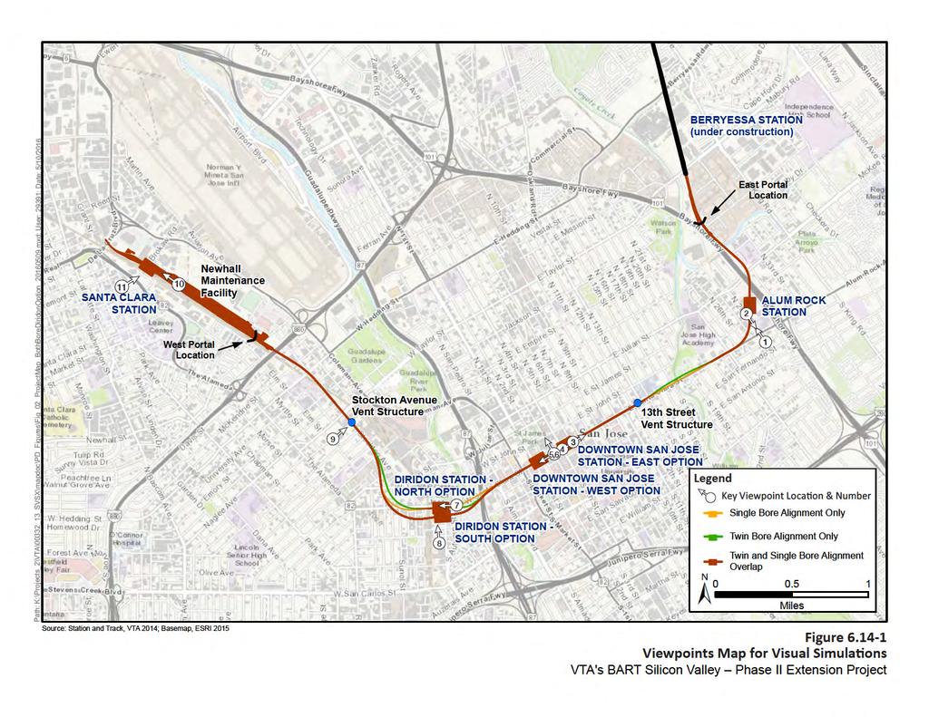
10 height and massing of the structural elements that are proposed at each location and are used to guide the visual analysis (refer to Figures through ). Figure shows the locations of the key viewpoints related to the TOJDs. Figures through show the existing conditions of key viewpoints relative to visual simulations of BART Extension buildout CEQA Thresholds of Significance In accordance with Appendix G of the State CEQA Guidelines, a project would have a significant impact if it would result in any of the conditions listed below. Have a substantial adverse effect on a scenic vista. Substantially damage scenic resources, including, but not limited to trees, rock outcroppings, and historic buildings within a state scenic highway. Substantially degrade the existing visual character or quality of the site and its surroundings, including scenic vistas. Create a new source of substantial light or glare that would adversely affect daytime or nighttime views in the area Environmental Consequences and Mitigation Measures This section identifies the impacts on visual quality and aesthetics under CEQA, as well as mitigation measures necessary to reduce the level of potentially significant and significant impacts to less-than-significant levels No Build Alternative The No Build Alternative consists of the existing transit and roadway networks and planned and transportation programmed improvements (see Chapter 2, Section 2.2.1, NEPA No Build Alternative, for a list of these projects), and other land development projects planned by the Cities of San Jose and Santa Clara. The No Build Alternative projects could result in effects on visual quality and aesthetics typically associated with transit, highway, bicycle, and pedestrian facilities, and roadway projects as well as land development projects. All individual projects planned under the No Build Alternative would undergo separate environmental review to identify effects on visual quality and aesthetics. Review would include an analysis of impacts and identification of mitigation measures to reduce potential impacts
11
12
13
14
15
16
17
18
19
20
21
22
23
24 It is reasonably foreseeable that the construction staging sites vacated after the construction of the BART Extension would be developed in accordance with the local general plans and area plans. Therefore, impacts due to construction and operation of these developments for visual resources, light, and glare would be similar to the TOJD. Projects planned under the No Build Alternative would, however, undergo separate environmental review to determine whether the projects would result in adverse visual impacts. Review would include an analysis of impacts and identification of mitigation measures to mitigate potential project impacts BART Extension Alternative Impact BART Extension AES-1: Have a substantial adverse effect on a scenic vista Construction The alignment and surrounding area are characterized by flat topography and do not contain any ridgelines or other topographic forms that are considered a scenic vista by the SJGP or SCGP. Additionally, views of the hillsides bordering San Jose and Santa Clara are not consistently visible from within the alignment. Existing buildings, trees, and infrastructure (e.g., utility lines, elevated roadways) obscure these views. Construction of the BART Extension would involve the use of heavy equipment, stockpiling of soils and materials, and other visual signs of construction. The presence of construction equipment and materials would be typical of large construction projects. There are no scenic vistas within or near the study area. Therefore, the presence of construction equipment would have no impact on a scenic vista, and no mitigation would be required. Operation No scenic vistas exist in the study area. Given the urbanized nature of the areas surrounding the stations, as well as the entirety of the alignment, there are no high-quality views from anywhere along the alignment. Therefore, there would be no impact on scenic vistas, and no mitigation would be required. Impact BART Extension AES-2: Substantially damage scenic resources, including, but not limited to trees, rock outcroppings, and historic buildings within a state scenic highway Construction The BART Extension would require removal of trees outside of the state scenic highway. Trees may be removed or trimmed at construction staging sites to allow for maximum area for construction laydown. Trees would be removed as needed to accommodate station boxes, entrance portals, ventilation facilities, and system facilities. Replacement trees would be planted in accordance with Mitigation Measure AES-CNST-A in Chapter 5, Section ,, and would be placed in the same viewshed where feasible
25 The replacement trees would be young trees that would take a few years to mature to full size. The replacement of trees would ensure that visual impacts due to loss of trees would be less than significant after implementation of mitigation. Operation There are no state-designated scenic highways in the vicinity of the alignment. The only officially designated state scenic highway within Santa Clara County is Highway 9, which is over 7 miles southwest of the BART Extension. Both San Jose and Santa Clara have several unique cultural resources stemming from each city s long history. As a result, several buildings are protected cultural resources and may also serve as key points of interest and scenic resources within a community. Refer to Chapter 4, Section 4.5, Cultural Resources, for a list of historically and architecturally significant buildings in the area. However, construction of the BART Extension would not substantially impair these buildings such that they are no longer considered historic. Therefore, implementation of the BART Extension would have a less-than-significant impact on any scenic resources, and no mitigation would be required. Operation of the BART Extension would not require any tree removal. Impact BART Extension AES-3: Substantially degrade the existing visual character or quality of the site and its surroundings, including scenic vistas Construction Construction of the BART Extension would involve the use of heavy equipment, stockpiling of soils and materials, and other visual signs of construction. In general, construction impacts that have the potential to degrade visual quality include the visual presence of construction equipment and material, and light and glare impacts from any nighttime construction work. Such effects would be somewhat more pronounced in residential areas or areas seen by substantial numbers of passing motorists, pedestrians, and bicyclists. Several construction staging areas (CSAs) have been identified along the alignment, as described in Chapter 5, NEPA Alternatives Analysis of Construction. Five of the CSAs would be within or adjacent to residential neighborhoods that would be the most sensitive to changes in visual setting and light and glare impacts. These CSAs include the Alum Rock/28 th Street Station site, 13 th Street ventilation facility site, Downtown San Jose Station East Option site, Stockton Avenue ventilation facility site, and Newhall Maintenance Facility. The underground stations would be constructed as cut and cover and, therefore, construction sites would be visible from adjoining areas. Short-term visual changes as a result of construction activities are common in urban and suburban areas. To minimize the visual elements of construction, screening techniques would be implemented by the contractor at the construction sites as appropriate. Construction areas would be maintained in an orderly manner, including proper containment and disposal of litter and debris to prevent dispersal onto adjacent properties and roadways. Construction
26 crews working at night would direct any artificial lighting onto the work area to minimize the spillover of light or glare onto adjacent areas. The incorporation of visual screening and other techniques designed to reduce visual effects as described above would minimize the degradation of visual character within the alignment affiliated with construction activities. Although construction activities would last for approximately 8 years, they would be phased throughout the alignment. Therefore, construction activities would not substantially degrade the existing visual character or quality of the site and its surroundings, a less-than-significant impact would result, and no mitigation would be required. Operation Alignment The majority of the BART Extension would be constructed and operated underground. Aboveground elements that would be visible from adjoining areas would be limited and are described below. In east San Jose, only a small portion of the alignment would be at grade from Mabury Road to Las Plumas Avenue, along with the associated aboveground structure at the tunnel portal. This area is currently occupied by an open, flat dirt lot and old railroad tracks. The visual landscape immediately adjacent to the segment of at-grade tracks is predominantly industrial, with large open storage areas, one- and two-story warehouse-style buildings, parking vehicles and trailers, and several overhead power lines. U.S. 101 travels along the southwest side of the alignment. Few viewer groups exist in this location, and viewer sensitivity is low given the industrial nature of the area. BART trains would be visible as they pass; however, given the proximity of the U.S. 101 corridor, the introduction of BART trains would not change the visual landscape. Therefore, the BART Extension would not substantially degrade the visual quality in this location. The alignment would again travel aboveground from the West Tunnel Portal near Newhall Street to the Santa Clara Station. The visual character of the at-grade portion in Santa Clara is dominated by modern-style multistory condos to the south, as well as large-scale modern offices and commercial strip mall style buildings. On the northeast side of the alignment, the visual character is defined mostly by overhead power lines and one- and two-story industrial and commercial buildings. Given that the at-grade portion is within the existing Caltrain corridor, which is already in transportation use, the BART Extension would be consistent with the visual landscape. Furthermore, the most sensitive users would be the residents along the southwest side; these residents live in the vicinity of an existing operational Caltrain corridor and, therefore, the impacts related to degradation of visual quality would be less than significant, and no mitigation would be required
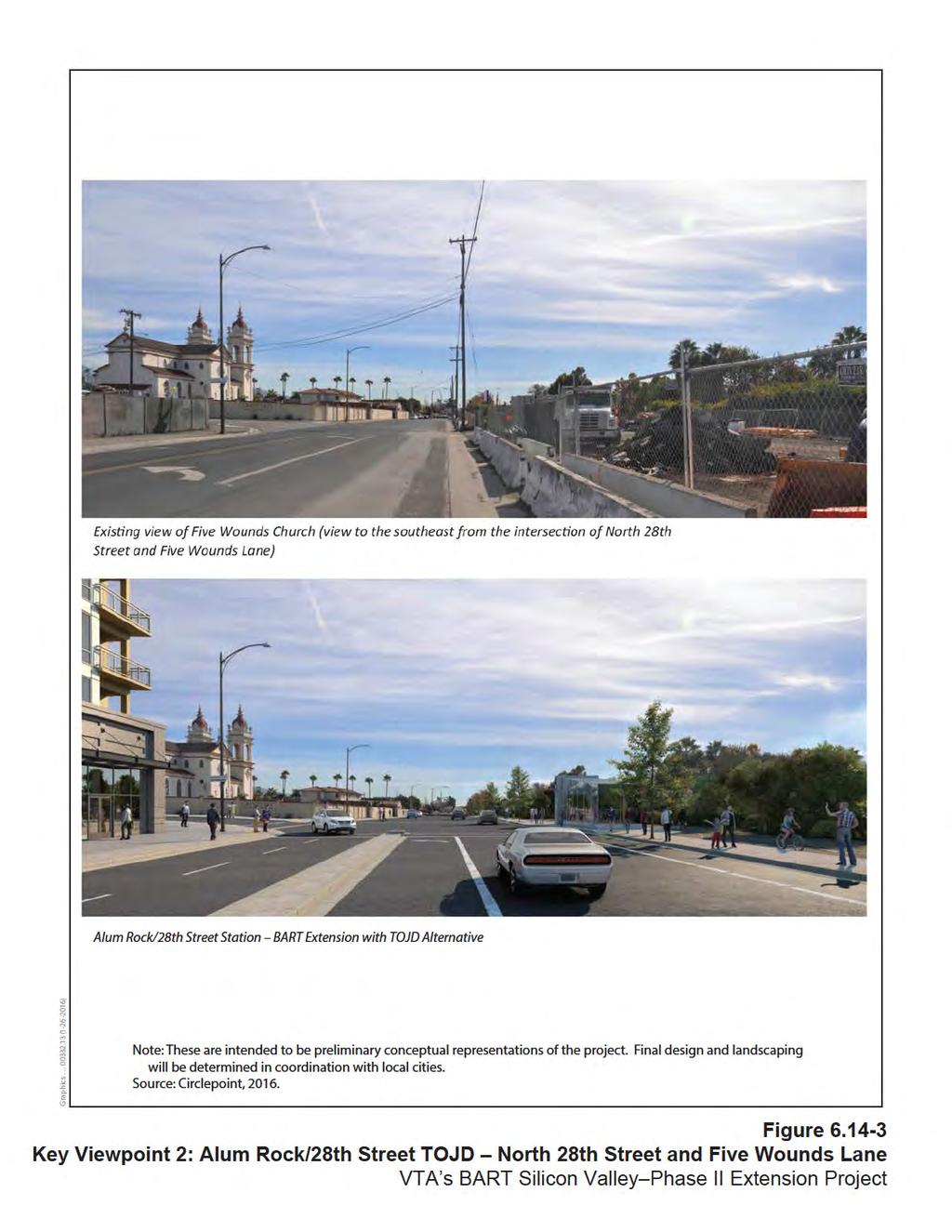
27 Station Locations VTA has taken measures to ensure public involvement throughout the design process for the BART Extension, as described in Chapter 4, Section 4.11, Land Use. Such community input has helped to guide the development of station locations and plans. Alum Rock/28 th Street Station Aboveground structures at the Alum Rock/28 th Street Station site would include station entrance portals, a parking structure, and system facilities. The most visually prominent new feature would be the parking structure, which would be up to seven levels. Additionally, there would be roadway improvements to North 28 th Street, including a pedestrian/bicycle/transit gateway into the station area with amenities such as signage, street trees, sidewalks, bicycle facilities, and pedestrian-scaled lighting. The existing visual character surrounding the Alum Rock/28 th Street campus is defined by commercial and large industrial low-rise buildings, surface parking lots, and historic Five Wounds National Portuguese Church and School (Five Wounds Church). As shown in Figure , the parking structure and station portal entrances would be designed to be set back from the Five Wounds Church. Although larger in scale and mass, the parking structure would be set back from Five Wounds Church such that it would not obstruct any views of the church. System facilities would be visually screened from public view. As a result, no substantial degradation of visual quality would occur with implementation of the BART Extension at the Alum Rock/28 th Street Station. The impact would be less than significant, and no mitigation would be required. Downtown San Jose East Station Option The visible aboveground features at this location would include station entrance portals and system facilities. Several portal entrance options in the sidewalks along Santa Clara Street between 2 nd and 7 th Streets are being evaluated. Other aboveground features include and emergency exhaust generator, which would be enclosed in a small structure at the southeast corner of Santa Clara Street and 6 th Street. One emergency ventilation facility would be located at each end of the station and enclosed in a structure approximately 12 feet high. The existing visual setting in this area includes views of large institutional and commercial buildings and a tree-lined streetscape. The buildings are a mix of old brick buildings and more modern concrete and glass buildings. The newer buildings are taller. The system facilities and BART station entrance portals would be designed to be visually consistent with the colors and materials of the existing buildings in the area. The mass and scale of these buildings would be much smaller. Streetscape improvements would be incorporated along Santa Clara Street between 7 th and 1 st Streets, and would be guided by San Jose s Master Downtown Streetscape Plan (City of San Jose 2003). Therefore, no substantial degradation of visual quality would occur; any impacts would be less than significant, and no mitigation would be required
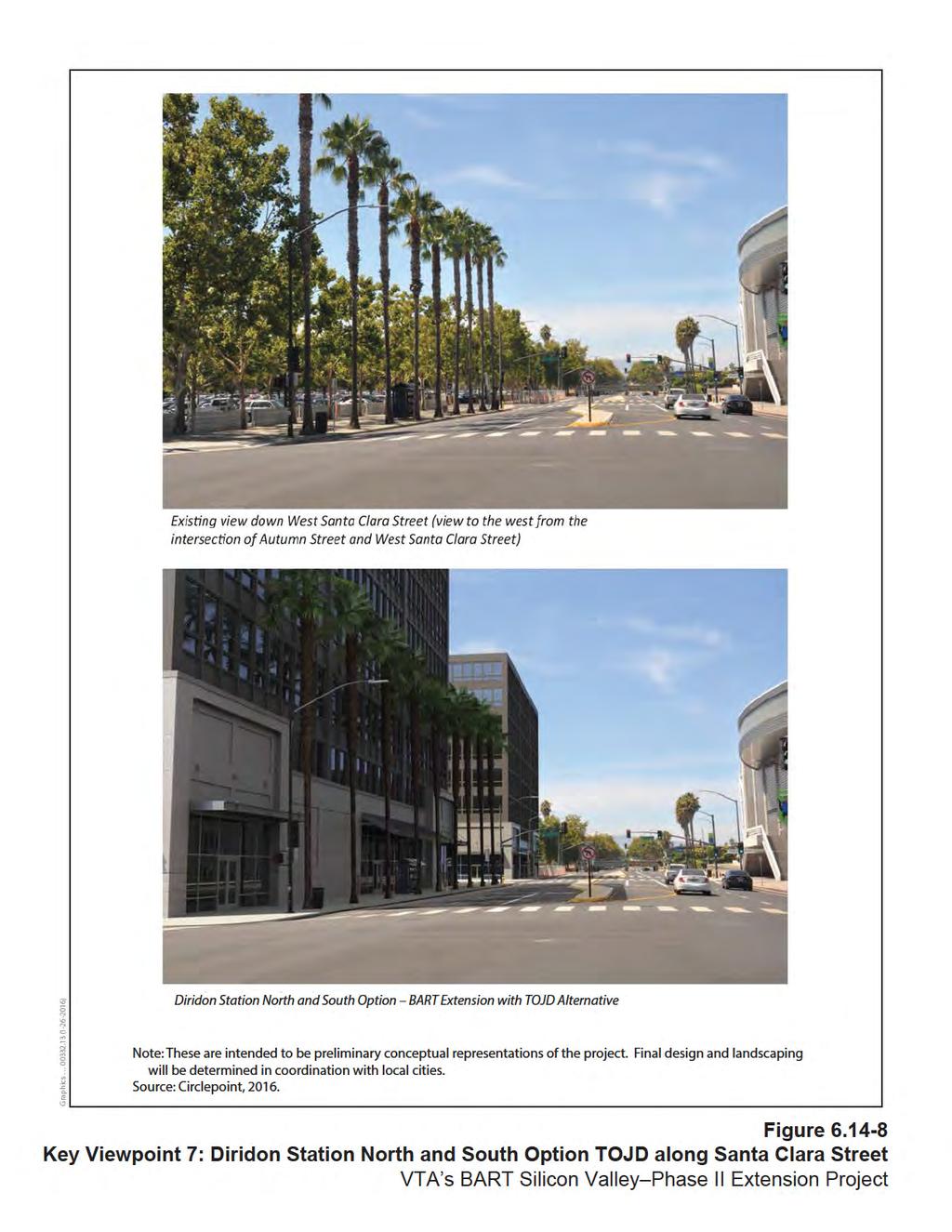
28 Downtown San Jose West Station Option The visible aboveground features for this station option would be similar to the Downtown San Jose East Station option described above. From 3 rd Street heading west along Santa Clara Street, the streetscape is dominated by street trees and predominantly one- to three-story historic-style commercial buildings. The mass and scale of buildings increases substantially around 1 st Street and Market Street. The system facilities and station entrance portals would be designed to be visually consistent with the mass and scale of the existing buildings in the area. They would also be neutral in color so as to not contrast with the color scheme of the existing commercial corridor. Streetscape improvements would be incorporated along Santa Clara Street between 7 th and 1 st Streets, and would be guided by San Jose s Master Downtown Streetscape Plan. Therefore, no substantial degradation of visual quality would occur; any impacts would be less than significant, and no mitigation would be required. Diridon Station South and North Options Aboveground features associated with the Diridon Station South and North Options would include station entrance portals, an emergency exhaust generator and other system facilities, which would be located in the existing parking lot onsite and surrounded by an approximately 9-foot-high concrete masonry unit (CMU) wall. No parking is proposed at this station. The existing visual setting around the Diridon Station is dominated by the historic Diridon Station and parking lots and the SAP Center building. The adjoining streets are tree lined, with small buildings. This area is already dominated by transportation uses including the existing Diridon Caltrain Station and bus transit center. Addition of BART station portals and system facilities would be consistent with both the existing transportation uses and visual environment. The station portal adjacent to the Diridon Caltrain Station would not affect its historic or visual integrity and would not obstruct any views of the Diridon Caltrain Station. The station entrance portals and system facilities would be designed for consistency in mass and scale with the existing visual landscape, as shown in Figure a and b. As such, impacts related to visual quality would be less than significant for both station options, and no mitigation would be required. Santa Clara Station Santa Clara Station would be an aboveground station, including an up to five-story parking structure north of Brokaw Road and east of the Caltrain tracks. Systems facilities would be surrounded by an approximately 12-foot-high CMU wall. The parking garage site was previously occupied by a FedEx shipping and receiving facility and is currently vacant; retail uses are located immediately adjacent to the northwest. The
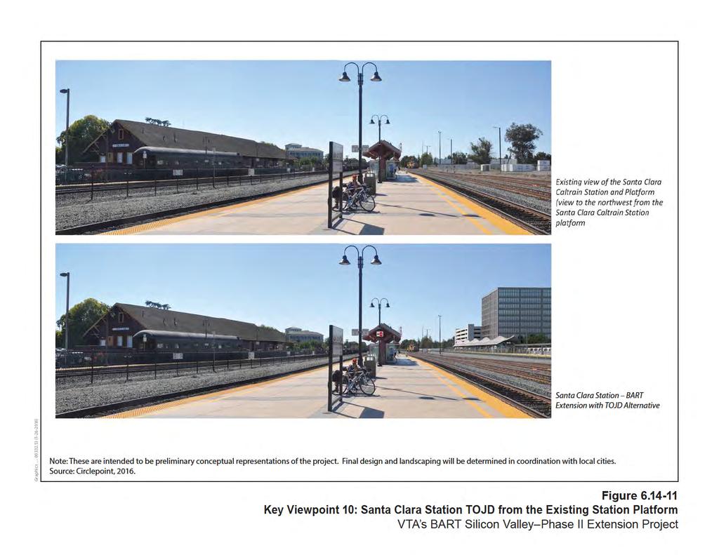
29 area surrounding the parking garage is mostly industrial. The existing Caltrain tracks and Santa Clara Caltrain Station are south of the parking garage site. The parking structure would therefore be constructed in a primarily industrial area. The BART station would be close to the existing Santa Clara Caltrain station. The Santa Clara Police offices are southwest of the BART station. The BART station would include a platform and canopy. The station would be similar to the existing Santa Clara Caltrain Station in terms of massing and scale. The visual quality in the area is likely to improve due to intensification of transit uses. As such, impacts related to visual quality would be less than significant, and no mitigation would be required. Newhall Maintenance Facility The Newhall Maintenance Facility would be constructed on the former Union Pacific Railroad (UPRR) Newhall Yard. The facility would include maintenance and engineering offices and a yard control tower (up to three stories in height). To provide for these functions, several buildings and numerous transfer and storage tracks would be constructed onsite. The visual character along the southwest side of the Newhall Maintenance Facility site is dominated by modern-style multistory condos. On the northeast side of the facility site, the visual character is defined mostly by overhead power lines and one- and two-story industrial and commercial buildings. The Newhall Maintenance Facility would be within the existing UPRR Newhall Yard and thus would blend with the existing visual character of the area. Additionally, the most sensitive viewers in the area are residents in condos near the Newhall Maintenance Facility along the southwest side of the alignment; however, they are separated from the Newhall Maintenance Facility site by a large concrete retaining wall and active railroad tracks and currently have views of the former UPRR Newhall Yard. Therefore, impacts related to visual quality would be less than significant, and no mitigation would be required. System Facilities/Ventilation Facilities BART supporting facilities include electrical facilities, traction power substations, high-voltage substations and switching stations, auxiliary power substations, gap breaker stations, train control equipment, ventilation facilities for the tunnels and underground stations, and pump stations. As previously described for system facilities associated with new BART station locations, they would be contained within system facility sites and visually screened from public view. Two mid-tunnel ventilation facilities are also proposed: one at the northwest corner of Santa Clara Street and 13 th Street and another east of Stockton Avenue south of Taylor Street. Each would be aboveground structures housing the equipment required to ventilate the BART tunnel. The area required to accommodate each ventilation facility would be approximately 110 by 200 feet in size and 12 feet high. Land uses surrounding the site of the 13 th Street ventilation facility are primarily commercial. Commercial and industrial land uses surround
30 the Stockton Avenue ventilation facility site. Residential uses are located in areas near both of these facilities; however, both sites would be surrounded by an approximately 9-foot-high CMU wall and would be designed to visually blend with the surrounding commercial buildings. Therefore, the impact would be less than significant, and no mitigation is required. Impact BART Extension AES-4: Create a new source of substantial light or glare that would adversely affect daytime or nighttime views in the area Construction Light and glare impacts could result from nighttime construction work. Such effects would be somewhat more pronounced in residential areas or areas seen by substantial numbers of passing motorists, pedestrians, and bicyclists. To minimize light and glare impacts, construction crews working at night would direct any artificial lighting onto the work area to minimize the spillover of light or glare onto adjacent areas. With the incorporation of light and glare screening techniques designed to reduce visual effects, no new substantial sources of light or glare would be created during construction, the impact would be less than significant, and no mitigation would be required. Operation BART-related features, such as new station entrance portals, parking structures, and system facilities, would create new sources of light and glare. Most of these structures would be made of concrete and, therefore, would not produce glare. Use of reflective surfaces, such as windows and glass, would be minimized to prevent glare. Station entrance portals would include pedestrian-scaled lighting, and the new parking structures would include lighting. There are many sources of existing light and glare along the alignment. The residential, industrial, and commercial uses in the vicinity currently generate light and glare from streetlights and exterior lighting for residential and commercial uses. Existing transportation facilities, such as light rail stations, include lighting. Lighting at new station entrance portals would be designed to focus on the BART Extension and minimize spillover of light and glare into adjacent areas. The station portals would be in mostly commercial and institutional areas; therefore, the potential for spillover impacts is minimal. System facilities would include minimal lighting and would be visually screened when within public view. Therefore, the impact would be less than significant, and no mitigation would be required
31 BART Extension with TOJD Alternative Impact BART Extension + TOJD AES-1: Have a substantial adverse effect on a scenic vista Construction Impacts of the BART Extension with TOJD Alternative would be similar to those described under the BART Extension Alternative. There are no scenic vistas in the vicinity. No impacts would occur, and no mitigation would be required. Operation Impacts of the BART Extension with TOJD Alternative would be similar to those described under the BART Extension Alternative. Given the urbanized nature of the areas surrounding the TOJDs, there are no high-quality views that would be obstructed by the TOJDs. Therefore, there would be no impact on scenic vistas, and no mitigation would be required. Impact BART Extension + TOJD AES-2: Substantially damage scenic resources, including, but not limited to trees, rock outcroppings, and historic buildings within a state scenic highway Construction and Operation Construction and operation impacts of the BART Extension with TOJD would be similar to those discussed under the BART Extension Alternative. No additional trees would be removed for the TOJD beyond those removed under the BART Extension Alternative. With implementation of Mitigation Measure AES-CNST-A, impacts would be less than significant. Impact BART Extension + TOJD AES-3: Substantially degrade the existing visual character or quality of the site and its surroundings, including scenic vistas Construction Construction impacts of the BART Extension with TOJD Alternative would be similar to those discussed under BART Extension Alternative. Construction TOJD sites would be adequately screened. Impacts would be less than significant, and no mitigation would be required. Operation Station Locations/TOJDs Alum Rock/28 th Street Station and TOJD The Alum Rock/28 th Street Station and TOJD would include aboveground structures, including station entrances, a parking structure, system facilities, and TOJD buildings. The most visually prominent new features onsite would be the parking structure and the TOJD
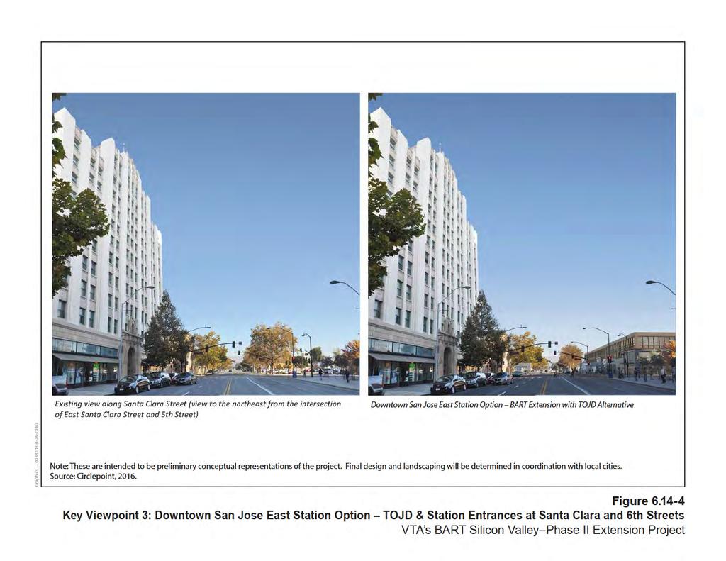
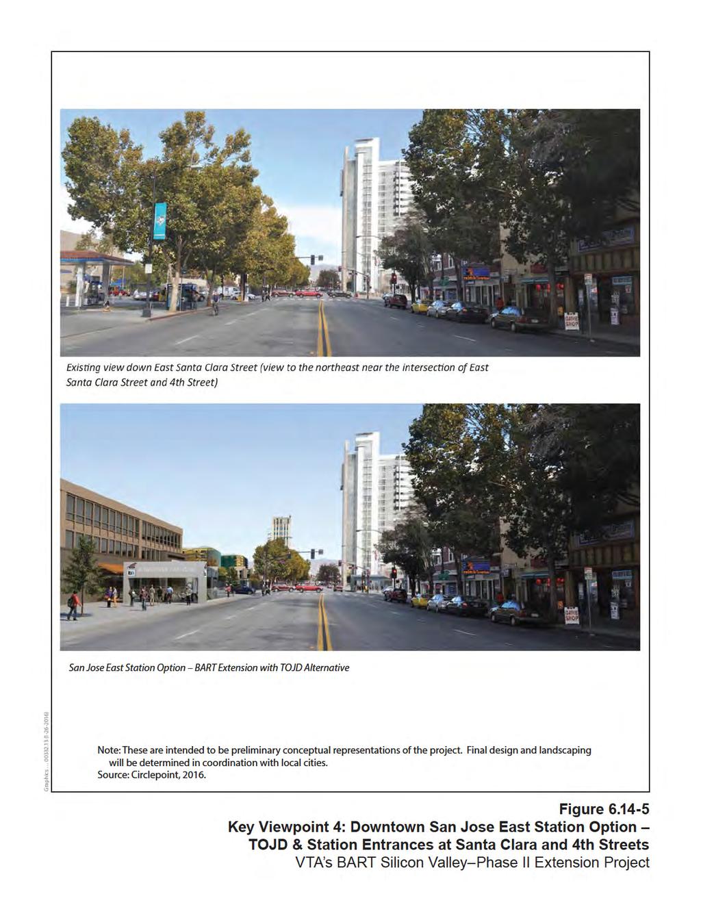
32 The parking structure would be up to seven levels, and the TOJD would be four to nine stories and over 500,000 square feet in size. The visual character surrounding the Alum Rock/28 th Street campus is defined by commercial and large industrial low-rise buildings, surface parking lots, and the visually prominent historic Five Wounds Church. Both the parking structure and TOJD would be taller but larger in mass than the surrounding industrial warehouses. As shown in Figures and , the parking structure and TOJD would be set back from the church, and no views to the church would be affected. Given the location of the Alum Rock/28 th Street Station and TOJD to be behind the Five Wounds Church along 28 th Street, views of the primary façade of the church that faces Alum Rock Avenue would remain unchanged. The design of the TOJD would be in accordance with the Five Wounds Urban Village Plan, which envisions this area to transition from industrial to other uses. The TOJD would help to improve the visual quality of the area by providing a community-oriented and pedestrian-friendly streetscape in a currently industrial area. System facilities would be visually screened from public view. As a result, no substantial degradation of visual quality would occur with implementation of the BART Extension with TOJD Alternative. The impact would be less than significant, and no mitigation would be required. Santa Clara Street/13 th Street TOJD TOJD would consist of a maximum of 13,000 square feet of ground-level retail along the street frontage facing Santa Clara Street. A large parking lot currently covers most of the site. The TOJD would be consistent with the mass and scale of the surrounding one- and two-story commercial land uses and would improve the visual quality of the area by developing the existing site from an empty paved parking lot to a new retail development. Therefore, the impact related to visual quality would be less than significant, and no mitigation would be required. Downtown San Jose Station East Option TOJD The visible aboveground features at this location would include three TOJDs, station entrance portals, and system facilities (refer to Figures through ). The three TOJD sites would be adjacent to the Downtown San Jose Station East Option between 7 th Street and 3 rd Street. Each of the three TOJDs would be up to three stories high, contain a mix of office and retail space, and range between 45,000 and 340,000 square feet in size. The visual landscape in this area includes views of large institutional and commercial buildings and a tree-lined streetscape. After 4 th Street heading west, the density of buildings increases and the styles transition to old town historic brick façades
33 The TOJDs, system facilities, and BART station entrance portals would be designed to be visually consistent with the mass and scale of the existing buildings in the area. They would also be neutral in color so as to not contrast with the color scheme of the existing commercial corridor. Streetscape improvements would be incorporated along Santa Clara Street between 7 th and 1 st Streets, and would be guided by San Jose s Master Downtown Streetscape Plan. Therefore, no substantial degradation of visual quality would occur; any impacts would be less than significant, and no mitigation would be required. Downtown San Jose Station West Option TOJD The visible aboveground features at this location would include one TOJD, station entrance portals, and system facilities (refer to Figure ). The TOJD would be along Santa Clara Street, west of 3 rd Street. The TOJD would be up to three stories high and consist of approximately 45,000 square feet of retail and office space. From 3 rd Street heading west along Santa Clara Street, the streetscape is dominated by street trees and predominantly one- to three-story historic-style commercial buildings. The mass and scale of buildings increases substantially around 1 st Street and Market Street, and the density of buildings decreases. The TOJD, system facilities, and station entrance portals would be designed to be visually consistent with the mass and scale of the existing buildings in the area. They would also be neutral in color so as to not contrast with the color scheme of the existing commercial corridor. Streetscape improvements would be incorporated along Santa Clara Street between 7 th and 1 st Streets, and would be guided by San Jose s Master Downtown Streetscape Plan. Therefore, no substantial degradation of visual quality would occur; any impacts would be less than significant, and no mitigation would be required. Diridon Station (South and North Option) TOJD TOJD at both the Diridon Station South and North Options would have the same footprint and would be located in the existing parking lots onsite. TOJD at Diridon would be up to eight stories high (refer to Figures and a/b). The SAP Center is a large building in scale and mass across the street, although not as tall as the TOJD. The Diridon Station Area Plan envisions this area to become concentrated with transit uses and transit-oriented development. Therefore, the TOJD would be consistent with the plans and the community s vision for this area. The TOJD would not affect the historic or visual integrity of the historic Diridon Caltrain Station. Therefore, no substantial degradation of visual quality would occur; any impacts would be less than significant, and no mitigation would be required. Stockton Avenue TOJD TOJD would be co-located on the east side of Stockton Avenue south of Taylor Street with the Stockton Avenue ventilation facility at the rear of the site (refer to Figure ). The TOJD would consist of a maximum of 15,000 square feet of ground-level retail. This area is currently occupied by industrial uses and is primarily covered with surface parking lots. The
4.16 Visual Quality and Aesthetics
 4.16 4.16.1 Introduction This section describes the affected environment and environmental consequences related to visual quality and aesthetics from operations of the NEPA Alternatives. Information regarding
Policies and Code Intent Sections Related to Town Center
 Policies and Code Intent Sections Related to Town Center The Town Center Vision is scattered throughout the Comprehensive Plan, development code and the 1994 Town Center Plan. What follows are sections
VILLAGE OF SKOKIE Design Guidelines for Mixed-Use Districts NX Neighborhood Mixed-Use TX Transit Mixed-Use CX Core Mixed-Use
 VILLAGE OF SKOKIE Design Guidelines for Mixed-Use Districts NX Neighborhood Mixed-Use TX Transit Mixed-Use CX Core Mixed-Use TABLE OF CONTENTS CHAPTER 1 SITE DESIGN Purpose 1 CHAPTER 2 SITE DESIGN Streetscape
4.1 Aesthetics Setting. a. Visual Character
 Environmental Impact Analysis Aesthetics 4.1 Aesthetics This section analyzes the proposed Specific Plan s impacts related to aesthetics, including the existing visual character of and scenic views in
4.11 Land Use Introduction Environmental and Regulatory Setting Environmental Setting
 4.11 4.11.1 Introduction This section describes the affected environment and environmental consequences related to land use from operations of the NEPA Alternatives. Information regarding land use and
WEST LOOP DESIGN GUIDELINES CHECKLIST
 WEST LOOP DESIGN GUIDELINES CHECKLIST Section 1.0 General Strategies 1.1 DESIGN EXCELLENCE: ENCOURAGE HIGH QUALITY AND INNOVATIVE DESIGN OF NEW BUILDINGS WITHIN THE WEST LOOP WITHOUT BEING PRESCRIPTIVE
PUBLIC RIGHT-OF-WAY IN THIS CHAPTER PUBLIC REALM
 PUBLIC RIGHT-OF-WAY This section provides design guidelines for improvements in the public right-of-way. The public right-of-way refers to streets, sidewalks, non-vehicular thoroughfares, parks and greenways
Buildings may be set back to create small plazas provided that these setbacks do not substantially disrupt the street wall s continuity.
 6-22 Community Design Street Walls and Street-front Setbacks The siting of buildings will play a critical role in establishing the character and sense of place for the District. Siting buildings at the
4.17 VISUAL QUALITY AND AESTHETICS
 4.17 VISUAL QUALITY AND AESTHETICS 4.17.1 INTRODUCTION AND METHODOLOGY This section assesses the visual affects of both the Baseline and BART alternatives. The visual analysis characterizes the SVRTC in
6.11 Land Use Introduction Regulatory Setting Regional Plans and Policies. Santa Clara Valley Transportation Authority
 6.11 6.11.1 Introduction This section discusses existing conditions and the regulatory setting regarding land use and describes impacts under CEQA that would result from construction and operation of the
Table of Contents. Elm Avenue Improvement Plan City of Waco, Texas. Introduction 1. Existing Context 1 Figure 1 2.
 Table of Contents Introduction 1 Existing Context 1 Figure 1 2 Plan Guidelines 3 Future Urban Form 4 The West-End 4 Main Street 6 The East-End 7 Figure 2 9 Public Improvement Recommendations 7 General
SUBCHAPTER 4-B GUIDELINES FOR THE B-3 COMMERCIAL CHARACTER AREA
 1 SUBCHAPTER 4-B GUIDELINES FOR THE B-3 COMMERCIAL CHARACTER AREA Downtown Bozeman should be the location of buildings of greatest height and intensity in the community. The following guidelines apply
4.0 Design Guidelines For The Village Centre. South fields Community Architectural Design Guidelines Town of Caledon
 4.0 Design Guidelines For The Village Centre 4.0 Design Guidelines for the Village Centre The Village Centre is the focal point of the entire South Fields Community and is designed as a traditional commercial
URBAN DESIGN BRIEF URBAN DESIGN BRIEF 721 FRANKLIN BLVD, CAMBRIDGE August 2018
 URBAN DESIGN BRIEF URBAN DESIGN BRIEF 721 FRANKLIN BLVD, CAMBRIDGE August 2018 DESIGN BRIEF CONTENTS PART A 1.0 INTRODUCTION 2.0 DESCRIPTION & ANALYSIS OF SITE CONTEXT 3.0 DESIGN CONSTRAINTS AND OPPORTUNITIES
INSTITUTIONAL USE DESIGN COMPATIBILITY TECHNIQUES
 INSTITUTIONAL USE DESIGN COMPATIBILITY TECHNIQUES INTRODUCTION Community institutions are an important part of the character and vitality of neighborhoods in Forsyth County. Institutional uses include
Nob Hill Pipeline Improvements Project EIR
 Section 3.1 Aesthetics This section addresses the visual aspects that may affect the views experienced by the public, including the potential to impact the existing character of each area that comprises
Future Five. Design/ Development Guidelines. January 2008 Amended June 08 per City Council motion
 Future Five Design/ Development Guidelines January 2008 Amended June 08 per City Council motion 5-Points Design Guidelines Table of Contents I. Introduction 3 II. Area boundaries 4 III. Review Process
13. New Construction. Context & Character
 13. New Construction Context & Character While historic districts convey a sense of time and place which is retained through the preservation of historic buildings and relationships, these areas continue
New-Cast Mixed-use Development Proposal King Street West, Newcastle, Ontario
 URBAN DESIGN BRIEF New-Cast Mixed-use Development Proposal King Street West, Newcastle, Ontario TABLE OF CONTENTS: 1.0 Executive Summary 2.0 Creating Vibrant and Sustainable Urban Places: Excerpts from
3.1 Aesthetics, Light, and Glare
 3.1 3.1.1 Introduction This section describes the existing aesthetics, light, and glare setting and potential effects from project implementation on visual resources and the site and its surroundings.
Clairtrell Area Context Plan
 Clairtrell Area Context Plan March 2005 Urban Development Services City Planning Contents 1. Introduction... 4 2. Development Structure... 6 2.1 Streets... 7 2.1.1 Sheppard Avenue and Bayview Avenue...
Town Center (part of the Comprehensive Plan)
") Town Center (part of the Comprehensive Plan) Mercer Island Town Center Looking North (2014) In 1994, a year-long process culminated in a set of design guidelines and code requirements for the Town Center
Town Center (part of the Comprehensive Plan) Mercer Island Town Center Looking North (2014) In 1994, a year-long process culminated in a set of design guidelines and code requirements for the Town Center
Community Design Plan
 Gardena General Plan 2006 Authority While the is not a required element of a General Plan, it is included because improving the community appearance and image is paramount to the overall quality of life
B L A C K D I A M O N D D E S I G N G U I D E L I N E S for Multi-family Development
 B L A C K D I A M O N D D E S I G N G U I D E L I N E S for Multi-family Development Adopted June 18, 2009 This section of the Design and focuses on site planning and design guidance for new multi-family
4.0 AFFECTED ENVIRONMENT AND ENVIRONMENTAL CONSEQUENCES
 4.0 AFFECTED ENVIRONMENT AND ENVIRONMENTAL CONSEQUENCES The following sections discuss the impacts associated with environmental resources for the tunneling method Alternatives A and B. The construction
DRAFT Northeast Quadrant of Kipling Avenue and Highway 7 DRAFT AUGUST 29, Goals Land Use. The goals of this Plan are to:
 AUGUST 29, 2017 12.15 Northeast Quadrant of Kipling Avenue and Highway 7 12.15.1 Goals 12.15.2 Land Use The goals of this Plan are to: 12.15.2.1 General Provisions: a) Ensure the development of a compact
EXISTING COMPREHENSIVE PLAN
 EXISTING COMPREHENSIVE PLAN Town Center Land Use Element: V. LAND USE POLICIES Town Center Mercer Island's business district vision as described in "Your Mercer Island Citizen-Designed Downtown" was an
PROPOSED WATERFRONT DISTRICT DESIGN STANDARDS
 PROPOSED WATERFRONT DISTRICT DESIGN STANDARDS 20.25 DESIGN REVIEW. 20.25.080 WATERFRONT DISTRICT A. Purpose. This section is intended to implement The Waterfront District Subarea Plan by: 1. Creating a
WATERFRONT DISTRICT DESIGN STANDARDS
 WATERFRONT DISTRICT DESIGN STANDARDS 20.25.080 WATERFRONT DISTRICT A. Purpose. This section is intended to implement The Waterfront District Subarea Plan by: 1. Creating a safe, vibrant mixed-use urban
Section 3.16 Visual Quality
 Chapter 3 Affected Environment, Environmental Consequences, and Mitigation Measures Section 3.16 Visual Quality Introduction This section discusses existing conditions, effects and mitigation measures
ATTACHMENT A. SILVERDALE DESIGN STANDARDS Amendments to the Waaga Way Town Center Chapter
 ATTACHMENT A SILVERDALE DESIGN STANDARDS Amendments to the Waaga Way Town Center Chapter Chapter 10. Waaga Way Town Center 10.1 Physical Identity Elements & Opportunities The Waaga Way Town Center includes
Hockessin Community Redevelopment Plan
 Hockessin Community Redevelopment Plan 3.1 Introduction The Community Redevelopment Plan for the Village of Hockessin is the result of the people s vision for a distinct village center that serves as the
4.9 Mendocino Avenue Corridor Plan Design Guidelines
 4.9 Mendocino Avenue Corridor Plan Design Guidelines The Mendocino Avenue Corridor Plan addresses the area between College Avenue and Steele Lane. Mendocino Avenue is a busy arterial that runs parallel
DRAFT. October Wheaton. Design Guidelines
 October 2011 DRAFT Wheaton Design Guidelines 2 Draft - Design Guidelines - Wheaton Sector Plan Contents 04 Section 1: Introduction 06 Section 2: Context 08 Section 3: Design Guidelines 09 Goal 1: Create
II. SINGLE FAMILY RESIDENTIAL
 II. SINGLE FAMILY RESIDENTIAL Castle Rock is made up of numerous individually built houses and subdivision tracts that have been developed during the past century. Some of the tracts are diverse in architectural
lot flankage Y street 16m 6m landscape strip for large site 3m landscape strip for small medium site
 Commercial General Commercial Objectives Create developments compatible with adjacent land uses in scale, function and character Define a consistent and attractive street edge with quality landscaping,
VISION AND GUIDING DESIGN PRINCIPLES
 pleasure point commercial corridor VISION AND GUIDING DESIGN PRINCIPLES Public Draft November 26, 2018 County of Santa Cruz with assistance from MIG CONTENTS PART I: INTRODUCTION AND VISION... 3 Community
Highland Village Green Design Guidelines
 Highland Village Green Design Guidelines Publishing Information Title Highland Village Green Design Guidelins Author The City of Calgary Status DRAFT - Proposed document subject to changes Additional Copies
COMMUNITY DESIGN. GOAL: Create livable and attractive communities. Intent
 COMMUNITY DESIGN Intent An attractive, well-designed County will attract quality development, instill civic pride, improve the visual character of the community, and create a strong, positive image for
appendix and street interface guidelines
 appendix five: building and street interface guidelines appendix 5 building and street interface guidelines BOULEVARDS Boulevards are generally characterized by higher levels of traffic movement at higher
VISUAL RESOURCES 1. INTRODUCTION 2. EXISTING CONDITIONS. a. Visual Character
 IV.A VISUAL RESOURCES 1. INTRODUCTION This section addresses the potential changes in visual character that would result from implementation of the proposed Wilshire and La Brea Project. Also evaluated
FUTURE LAND USE ELEMENT
 FUTURE LAND USE ELEMENT GOAL I: To create and sustain a great place to live, play, and prosper Objective 1: The City of Ocala shall incorporate the principles and strategies of the Ocala 2035 Vision into
4. INDUSTRIAL 53 CASTLE ROCK DESIGN
 4. INDUSTRIAL 53 CASTLE ROCK DESIGN CASTLE ROCK DESIGN 54 4. INDUSTRIAL Overview Well-designed and attractive industrial centers are the product of blending economic realities with both functional and
V. Urban Design A. INTRODUCTION B. CITY IMAGE
 V. Urban Design A. INTRODUCTION Urban design refers to the physical form and development of a city from the individual neighborhood to the overall city scape. In the largest sense, urban design encompasses
Wide asphalt driveway abutting school property. garage built with incompatible materials, too close to park. incompatible fencing materials
 Wide asphalt driveway abutting school property incompatible fencing materials garage built with incompatible materials, too close to park Lack of plantings as a buffer between private property and open
Residential Design Guidelines
 Residential Design Guidelines Single-Family Residential Design Guidelines Introduction These guidelines seek to provide property owners, designers and developers with a clear understanding of the City
A. Background Summary of Existing Challenges and Potential Possibilities. 1. Summary of Existing Assets and Potential Opportunities
 A. Background 1 A Main Street Master Plan Study was performed and completed in October of 2007. The study was initiated to review current land uses and development patterns along Main Street, from Parrish
Town Center. Block 5 Existing multifamily residential units are expected to remain.
 Area Guidelines Germantown s districts should be developed as distinct communities with unique features that are supported through the guidelines. The guidelines not only help distinguish these districts
Chapter PEDESTRIAN COMMERCIAL (PC) ZONING DISTRICT
 ZONING DISTRICT") Chapter 11-17 PEDESTRIAN COMMERCIAL (PC) ZONING DISTRICT Sections: 11-17-01 GENERAL PURPOSE 11-17-02 PERMITTED BUILDING TYPES 11-17-03 USES PERMITTED WITH DESIGN REVIEW 11-17-04 USES PERMITTED BY CONDITIONAL
Chapter 11-17 PEDESTRIAN COMMERCIAL (PC) ZONING DISTRICT Sections: 11-17-01 GENERAL PURPOSE 11-17-02 PERMITTED BUILDING TYPES 11-17-03 USES PERMITTED WITH DESIGN REVIEW 11-17-04 USES PERMITTED BY CONDITIONAL
FRUITVALE TRANSIT VILLAGE (Phase 2) Residential Project
 Residential Project") FRUITVALE TRANSIT VILLAGE (Phase 2) Residential Project DEVELOPER: SIGNATURE PROPERTIES ARCHITECT: HKIT ARCHITECTS April 23, 2010 TABLE OF CONTENTS 3 Vision 4 Description of Site 5 Guiding Concepts 6
FRUITVALE TRANSIT VILLAGE (Phase 2) Residential Project DEVELOPER: SIGNATURE PROPERTIES ARCHITECT: HKIT ARCHITECTS April 23, 2010 TABLE OF CONTENTS 3 Vision 4 Description of Site 5 Guiding Concepts 6
Appendix A COMMUNITY IMPROVEMENT PLAN DESIGN GUIDELINES
 Appendix A COMMUNITY IMPROVEMENT PLAN DESIGN GUIDELINES INTRODUCTION The continuous and desirable improvement of Arnprior requires a clear understanding of what is envisioned for the Town. These Design
URBAN DESIGN BRIEF REPORT
 URBAN DESIGN BRIEF REPORT PREPARED FOR 2568401 ONTARIO INC NEW GASBAR, CONVENIENCE STORE & CARWASH DEVELOPMENT @ 1509 FANSHAWE PARK ROAD WEST LONDON, ONTARIO GAMA ENGINEERING INC. PROJECT NUMBER 1669 PREPARED
Regency Developments. Urban Design Brief. Holyrood DC2 Rezoning
 Regency Developments Urban Design Brief Holyrood DC2 Rezoning Stantec Consulting Ltd. 7-31-2017 1. Overview Regency Developments intends to rezone the lands located at 8510 and 8511 93 Avenue, within the
Resolution : Exhibit A. Downtown District Design Guidelines March 2003
 Resolution 03-011: Exhibit A Downtown District Design Guidelines March 2003 DOWNTOWN DISTRICT DESIGN GUIDELINES CITY OF SOUTHLAKE, TEXAS Adopted March 2003 1 DOWNTOWN DISTRICT DESIGN GUIDELINES Adopted
GUIDELINES REPLACEMENT HOUSING GUIDELINES LOCATION INTRODUCTION URBAN DESIGN GUIDELINES
 Replacement housing in the former City of North York will be consistent with the following urban design guidelines. They provide a framework for residential re-development in the former City of North York
FLORIN ROAD CORRIDOR Site Plan and Design Review Guidelines Checklist
 FLORIN ROAD CORRIDOR Site Plan and Design Review Guidelines Checklist Applicant s Name: Project Address: Phone: Email: Applicant shall fill out the design guidelines checklist for all guidelines applicable
The Village. Chapter 3. Mixed Use Development Plan SPECIFIC PLAN
 The Village SPECIFIC PLAN Chapter 3 3.1 INTRODUCTION 3.1.1 Purpose This Chapter describes the development regulations applicable to the Mixed-Use and Transit Center Planning Areas. These form-based regulations
The University District envisions, in its neighborhood
 Envisioning the University District Link Light Rail in Seattle s neighborhoods CIY OF SEALE CONCEP-LEVEL SAION AREA PLANNING RECOMMENDAION RESOLUION # 30165 EXHIBI L Vision 08.2000 he University District
V. Gateways GATEWAYS / V-1
 V. GATEWAYS / V-1 Many of Chesapeake s gateways are located on highways and call for bold and attractive designs that motorists can understand, appreciate, and enjoy. can also take the form of natural
Derry Green Corporate Business Park
 Town of Milton Derry Green Corporate Business Park Urban Design Guidelines BMI/Pace - June 2010 Draft 3 Prepared by: Brook McIlroy Planning + Urban Design / Pace Architects Suite 300-51 Camden Street Toronto,
Standards (R-3) Figure B-11: R-3 Residential Standards Exhibit
 Figure B-11: R-3 Residential Standards Exhibit") Avila Ranch Avila Ranch Specific Plan Development Standards High Medium Density - High Residential Density Residential Lot and Building Lot and Standards Building (R-3) Standards (R-3) EXAMPLES These sketches
Avila Ranch Avila Ranch Specific Plan Development Standards High Medium Density - High Residential Density Residential Lot and Building Lot and Standards Building (R-3) Standards (R-3) EXAMPLES These sketches
WESTSIDE SUBWAY EXTENSION PROJECT. Addendum to the Visual and Aesthetic Impacts Technical Report
 PROJECT to the Visual and Aesthetic Impacts Technical Report August 2011 Visual and Aesthetic Impacts Technical Report SUMMARY On October 28, 2010, the Metro Board selected the Westwood/VA Hospital Extension
CHAPTER 3. Design Standards for Business, Commercial, Industrial, Recreational and Institutional Uses
 CHAPTER 3 Design Standards for Business, Commercial, Section Number Title Ordinance Number Date of Ordinance 16-3-1 Applicability 2006-11 2008-04 07-01-08 16-3-2 Uniform Standards for Architectural Design
920 BAYSWATER AVENUE PROJECT
 920 BAYSWATER AVENUE PROJECT VISUAL ASSESSMENT Prepared for the City of Burlingame Prepared by Circlepoint 46 S First Street, San Jose, CA 95113 June 2018 This page intentionally left blank. 920 Bayswater
SECTION TWO: Overall Design Guidelines
 SECTION TWO: Overall Design Guidelines This section provides overall design principles and guidelines for the Gardnerville Mixed-use Overlay. They provide criteria for mixed-use places consisting of residential,
3.1 community vision. 3.3 required plan elements
 Chapter 3 Community Form 3.1 community vision 3.2 Parks & landscaping concepts 3.3 required plan elements D R A F T 20 Community Form Chapter 3 3.0 Community form 3.1 community vision The Specific Plan
The transportation system in a community is an
 7 TRANSPORTATION The transportation system in a community is an important factor contributing to the quality of life of the residents. Without a sound transportation system to bring both goods and patrons
CHAPTER 13 DESIGN GUIDELINES
 CHAPTER 13 DESIGN GUIDELINES Section 1300.00 Section 1300.01 Design Guidelines Purpose The purposes of this section are to: A. The purpose of this Section is to establish procedures and standards to serve
Millbrae TOD #2 Project Analysis
 Millbrae TOD #2 Project Analysis Project Description A Site Development Permit and Conditional Use Permit are proposed to allow for a mixed-use transitoriented development on approximately 9 Acres located
Chapter 4. Linking Land Use with Transportation. Chapter 4
 Chapter 4 Linking Land Use with Transportation Chapter 4 59 Chapter 4 Linking Land Use with Transportation Community Design and Transportation Program Introduction Since the 1950s, the predominant development
FREEWAY/TOURIST DISTRICT
 FREEWAY/TOURIST DISTRICT DESIGN STANDARDS FOR THE CITY OF MOUNTLAKE TERRACE March, 2014 MOUNTLAKE TERRACE FREEWAY/TOURIST DESIGN STANDARDS March, 2014 1 TABLE OF CONTENTS Introduction...1 Design Site Design
Mark-up of the effect of the proposed Bronte Village Growth Area OPA No.18 on the text of section 24, Bronte Village, of the Livable Oakville Plan
 Mark-up of the effect of the proposed Bronte Village Growth Area OPA No.18 on the text of section 24, Bronte Village, of the Livable Oakville Plan Notes: This document is provided for information purposes
Chapter 3: Office & Office Mixed-Use Project Types
 Chapter Contents Purpose... 3-2 Applicability and Use Types...3-3 (1) Site Design...3-4 Building Placement and Orientation...3-5 Circulation and Vehicle Parking...3-6 Bicycle/Pedestrian Amenities...3-8
6. DOWNTOWN. The Downtown Element focuses on supporting and expanding the vitality and enhancement of Downtown Chico as the City s central core.
 VISION In 2030, Downtown Chico is the heart of the community and the center of cultural activity. Engaging and active at the street level, it is a multi-story, mixed-use hub, with specialty retail, restaurants,
CHAPTER FIVE COMMUNITY DESIGN
 CHAPTER FIVE COMMUNITY DESIGN CHAPTER FIVE - COMMUNITY DESIGN Assumptions Frazier Park and Lebec have historically developed according to different patterns of spatial form. While both communities are
Site Planning. 1.0 Site Context. 2.0 Pedestrian Circulation Systems. Pag e 2-23
 The following photographs from throughout the country illustrate key urban design principles. Photographs are provided to illustrate the overall urban design concepts described in Chapter 1 of the Downtown
Proposed for Vic West Neighbourhood Plan. Design Guidelines for Intensive Residential Development - Townhouse and Attached Dwelling
 Proposed for Vic West Neighbourhood Plan Design Guidelines for Intensive Residential Development - Townhouse and Attached Dwelling Design Guidelines for Intensive Residential Development - Townhouse and
City of Long Beach. creating vibrant and exciting places
 City of Long Beach creating vibrant and exciting places Land Use Element Urban Design Element Overview of the two draft General Plan elements Discuss areas of change Economic goals of the plans Case study
Figure BE-4: Urban Form - Corridors. Urban Form and Land Use. Page BE-24 Redwood City General Plan S A N F R A N C I S C O B A Y.
 and Land Use Bird Island S A N F R A N C I S C O B A Y Foster City Bair Island Belmont Greco Island San Carlos Veterans Blvd. El Camino Real Broadway Middleeld Rd. Menlo Park Woodside Rd. Features El Camino
DEVELOPMENT CONTROLS MEDICAL DISTRICT
 6.01. GENERAL DESIGN GUIDELINES A. Site Planning B. Architectural Design C. Medical Facility Signage & Lighting D. Exhibit 48. ARCHITECTURAL DESIGN CONCEPTS 6.02. MEDICAL FACILITY STANDARDS & GUIDELINES
5.1 AESTHETICS Environmental Setting Scenic Views FONTANA FORWARD GENERAL PLAN UPDATE DRAFT ENVIRONMENTAL IMPACT REPORT
 5.1 AESTHETICS This section describes the City s scenic resources, and landscape and neighborhood characteristics, and addresses the potential impacts on aesthetic and visual resources associated with
Cha p t e r 2: Ge n e r a l De s i g n Gu i d e l i n e s
 Downtown Ann Arbor Design Guidelines Cha p t e r 2: Ge n e r a l De s i g n Gu i d e l i n e s This chapter presents general design guidelines for new site plan or PUD projects in downtown Ann Arbor. The
CHAPTER 10 AESTHETICS
 CHAPTER 10 AESTHETICS CHAPTER 10 AESTHETICS This section identifies and evaluates key visual resources in the project area to determine the degree of visual impact that would be attributable to the project.
The impacts examined herein take into account two attributes of aesthetic values:
 IV. ENVIRONMENTAL IMPACT ANALYSIS This section addresses the potential impacts to views and aesthetics as a result of the proposed Project at the Project Site and the development scenarios analyzed for
Corridor Identity. Section 9. Introduction. Corridor Guiding Principles
 Corridor Identity An attractive and healthy community is a critical element of a quality place, and the design of quality places is a balance between environmental, economic, and social considerations.
Urban Design Manual PLANNING AROUND RAPID TRANSIT STATIONS (PARTS) Introduction. Station Study Areas
 Introduction. Station Study Areas") 111111 PLANNING AROUND RAPID TRANSIT STATIONS (PARTS) Introduction The ION rapid transit system will link Waterloo, Kitchener and Cambridge through a central transit corridor (CTC). There are a number
111111 PLANNING AROUND RAPID TRANSIT STATIONS (PARTS) Introduction The ION rapid transit system will link Waterloo, Kitchener and Cambridge through a central transit corridor (CTC). There are a number
The open space system should provide connective elements, relate to natural resources, and enhance the suburban character of the landscape..
 The open space system should provide connective elements, relate to natural resources, and enhance the suburban character of the landscape.. Mixed-use and infill development should maintain or enhance
BUSINESS DISTRICT DESIGN GUIDELINES
 Des Plaines, Illinois Prepared for the City of Des Plaines by: The Lakota Group Laurie Marston, AICP March 2005 Section 5: Streetscape Elements Business District Design Guidelines STREETSCAPE ELEMENTS
Five Wounds Urban Village Plan
 Five Wounds Urban Village Plan Approved by the City Council on November 19, 2013 TABLE OF CONTENTS INTRODUCTION...5 BACKGROUND AND PLANNING PROCESS...6 LAND USE...8 A. Planned Growth Capacity and Objectives...9
Gold Line Bus Rapid Transit Transit Oriented Development (BRTOD) Helmo Station Area Plan
 Helmo Station Area Plan") Appendix F Gold Line Bus Rapid Transit Transit Oriented Development (BRTOD) Helmo Station Area Plan Introduction and Purpose of the Plan The Gold Line Bus Rapid Transit facility is an eleven-mile dedicated
Appendix F Gold Line Bus Rapid Transit Transit Oriented Development (BRTOD) Helmo Station Area Plan Introduction and Purpose of the Plan The Gold Line Bus Rapid Transit facility is an eleven-mile dedicated
Chapter IV: Development Pattern
 Chapter IV: Development Pattern Introduction The 2002 Prince George s County Approved General Plan designates three growth policy tiers Developed, Developing, and Rural as well as three center designations
4.14 VISUAL QUALITY AND AESTHETICS
 4.14 VISUAL QUALITY AND AESTHETICS This section describes the existing aesthetic characteristics along the SVRTC including visual quality, prominent features, and scenic resources. This section also describes
DRAFT. 10% Common Open Space
 % OF CHARLOTTE IS CATEGORIZED AS A. LAND USES : Placeholder map displaying location of Place Type GOALS: Accommodate XX% of future growth. Provide a concentration of primarily commercial and civic activity
Housing and Coach House Guidelines - Ladner
 Housing and Coach House Guidelines - Ladner Policy D.8: Encourage Compatible Housing Design Encourage housing design that is sensitive to existing single family housing neighbourhoods by requiring a design
The Baileys Planning District portion of the Comprehensive Plan contains site design recommendations for both the Baileys Crossroads Community
 The Baileys Planning District portion of the Comprehensive Plan contains site design recommendations for both the Baileys Crossroads Community Business Center and the Seven Corners Community Business Center.
Complete Neighbourhood Guidelines Review Tool
 Complete Neighbourhood Guidelines Review Tool Prepared By: City of Regina Planning Department October 2014 Page 1 of 14 Community Development Review Checklist for Secondary Plans and Concept Plans The
CHAPTER 2: FUTURE LAND USE CONCEPTS
 CHAPTER 2: FUTURE LAND USE CONCEPTS INTRODUCTION The future land use concepts presented in this chapter are an expression of community support for a viable and vital US 50 Corridor. Land use recommendations
5.1 Site Plan Guidelines
 5. Community Core Guidelines Development of the Community Core will take place by plan of subdivision and site plan approval. It will occur in a phased manner that will reflect the timing of residential
Rosslyn Plaza PDSP (SP #422) SPRC Staff Presentation
 SPRC Staff Presentation") Rosslyn Plaza PDSP (SP #422) SPRC Staff Presentation ote Guiding Principles included in this document are taken from the latest working draft of the Guiding Principles dated. The illustrations included
Rosslyn Plaza PDSP (SP #422) SPRC Staff Presentation ote Guiding Principles included in this document are taken from the latest working draft of the Guiding Principles dated. The illustrations included
A Vibrant Downtown. Chapter 5 Cary Public Art Opportunities 31
 A Vibrant Downtown Cary s vision for Downtown is a unique, vibrant, dynamic, pedestrian friendly location; a regional destination and a place to live, work, and recreate, according to the 2001 Town Center