Mimico-Judson Secondary Plan and Urban Design Guidelines Final Report
|
|
|
- Pamela Ryan
- 6 years ago
- Views:
Transcription
1 PG11.4 STAFF REPORT ACTION REQUIRED Mimico-Judson Secondary Plan and Urban Design Guidelines Final Report Date: March 16, 2016 To: From: Wards: Reference Number: Planning and Growth Management Committee Chief Planner and Executive Director, City Planning Division Ward 6 Etobicoke-Lakeshore P:\2016\ClusterB\PLN\PGMC\PG16043 SUMMARY This report presents and seeks City Council approval of the recommended Mimico- Judson Secondary Plan and Urban Design Guidelines. Together, the Secondary Plan and Guidelines provide a framework to guide the revitalization of the Mimico-Judson Regeneration Area. The recommended Secondary Plan and Guidelines result from the Mimico-Judson Regeneration Areas Study that was initiated in 2013, upon Council s redesignation of the subject lands from Employment Areas to Regeneration Areas as part of the Municipal Comprehensive Review of employment lands. The Regeneration Areas Study consisted of extensive public engagement, including a dedicated working group and multiple technical studies conducted by consultants retained by the City. The Secondary Plan policies are based on four guiding principles: (1) retain and expand business through land use certainty and flexible mixed use regeneration; (2) unlock underutilized lands for transit supportive mixed use development; (3) protect and support existing operations and future expansion opportunities at the Willowbrook 1
2 Rail Maintenance Facility; and (4) foster a connected and complete community. This report recommends that Council adopt the revised Secondary Plan and Urban Design Guidelines. The report outlines the key findings from additional engagement with affected landowners and summarizes the revisions to the Secondary Plan that have been incorporated since Planning and Growth Management Committee's consideration of the proposed Secondary Plan at its meeting on January 20, RECOMMENDATIONS The Chief Planner and Executive Director, City Planning Division recommends that: 1. City Council amend the Official Plan for the lands shown on Attachment 1 to this report and adopt the Mimico-Judson Secondary Plan, attached as Attachment 1 to this report. 2. City Council adopt the Mimico-Judson Urban Design Guidelines, attached as Attachment 2 to this report. 3. City Council direct staff to apply the Mimico-Judson Urban Design Guidelines in the review of all new development applications and public initiatives for lands located within the Secondary Plan Area. 4. City Council authorize the City Solicitor to make such stylistic and technical changes to the proposed Official Plan Amendment No. 331 as may be required. Financial Impact The recommendations in this report have no financial impact. The Mimico-Judson Secondary Plan identified in Recommendation number 1 contains the four following municipal infrastructure projects that are anticipated to be delivered through the development of private lands: (1) Grand Avenue Extension; (2) Mimico- Judson Greenway; (3) New Public Park; and (4) Pedestrian and Cycling Overpass over Royal York Road. These infrastructure projects are intended to support future development. Staff will report on any financial impacts that may be necessary to deliver these infrastructure projects, as required. DECISION HISTORY At its meeting of January 20, 2016, Planning and Growth Management Committee considered a Directions Report dated October 28, 2015 from the Chief Planner and Executive Director, City Planning (see Attachment 3). This report presented the results of the Mimico-Judson Regeneration Area Study. The report included a draft Secondary Plan, which would redesignate all lands from Regeneration Areas to other land use designations. Lands west of Royal York Road, south of Judson Street, were proposed to be redesignated Employment Areas, while lands east of Royal York Road, were proposed 2
3 to be redesignated to a mix of Employment Areas and Mixed Use Areas. The Directions Report included detailed information about previous Council decisions, the study area and surrounding community, the relevant policy framework, study process, consultation process and the draft Secondary Plan. Planning and Growth Management Committee directed the Chief Planner and Executive Director, City Planning to distribute the draft Secondary Plan to the public to be considered at a statutory public meeting held by Planning and Growth Management Committee on April 6, It also directed City staff to bring forward the Mimico- Judson Urban Design Guidelines. This decision history can be accessed at this link: Vision for the Secondary Plan Area The recommended Mimico-Judson Secondary Plan is the outcome of the results of the Regeneration Areas Study completed for the area. The Secondary Plan would provide a development framework for continued and expanded employment opportunities as well targeted opportunities to introduce residential uses and is based on four guiding principles. 1. Retain and expand business through land use certainty and flexible mixed use regeneration The Secondary Plan would continue to protect the area's economic function by providing land use certainty for existing and new businesses to operate in the area and requiring that all new development in Mixed Use Areas include an employment component either onsite or within the same block. The Mimico Village Business Improvement Area also plays an important role in the local economy that should be enhanced and reinforced through the policies of this Secondary Plan. 2. Unlock underutilized lands for transit supportive mixed use development Intensifying both residential and employment uses in the Mimico Triangle Area within walking distance of the Mimico GO Station would leverage the presence of existing transit infrastructure to balance transportation choices for new residents and employees. 3. Protect and support existing operations and future expansion opportunities at the Willowbrook Rail Maintenance Facility The Willowbrook Rail Maintenance Facility provides - and will continue to provide - a crucial role in Metrolinx's future plans to expand GO Train service throughout the Greater Toronto and Hamilton Area. Retaining lands adjacent to the yard for employment uses would apply land use separation as a form of mitigation from impacts that may be generated by this rail yard. This separation would protect for future expansion of Metrolinx operations and ensure that the lands act as a buffer between the yards and the existing established neighbourhood to the north enabling the current operations at Willowbrook to continue without causing land use compatibility issues. 3
4 4. Foster a connected and complete community The Secondary Plan would provide policy guidance to achieve a complete community where people could live, work and undertake activities of daily life within walking distance to higher order transit. The proposed Grand Avenue Extension and Mimico- Judson Greenway are significant components of this Secondary Plan and would achieve improved access to the Mimico GO Station and connectivity across Royal York Road for pedestrians and cyclists. These improvements would provide important infrastructure to connect and integrate the Secondary Plan Area with nearby communities. Revisions to the Draft Mimico-Judson Secondary Plan The following section provides an overview of the proposed revisions to the Draft Mimico-Judson Secondary Plan considered by Planning and Growth Management Committee at its meeting of January 20, The recommended Secondary Plan policies have been revised to reflect comments received from City Divisions and input from area landowners. Official Plan Amendment No. 331 (OPA 331) Additional amendments to the Official Plan are required to implement the recommended Secondary Plan, which are contained in OPA 331. The Urban Structure Map (Map 2) of the Official Plan needs to be amended to identify those lands recommended to be retained as Employment Areas. An amendment to Schedule 1 of the Official Plan would also be necessary to further achieve the necessary right-of-way width on Judson Street. Vision The Vision section was modified to identify the nearby Mimico Village Business Improvement Area (BIA) as an important consideration in the future development of the Secondary Plan Area. 1. Land Use The policies in the Land Use section were revised to clarify that the recommended employment uses are uses that support the economic function of the Secondary Plan Area. A policy was added to specify the uses that are supportive of the economic function of the Secondary Plan Area include, but are not limited to: office, light industrial and manufacturing, media-based and retail that serves the needs of area employees. To protect the Mimico Village Business Improvement Area, clarification was added to indicate that non-residential uses should be complementary to the Mimico Village Business Improvement Area. The policy related to rail safety and mitigation was refined to provide additional clarity to require a 30 metre setback for residential and other sensitive land uses from their respective property lines bordering the rail corridor and should provide appropriate mitigation and safety features. 2. Economic Revitalization The Economic Revitalization policies were refined to clarify that the minimum required gross floor area of uses that support the economic function of the Secondary Plan Area are to be built prior to, or concurrent with, new development. This clarification illustrates 4
5 the policy intent to have non-residential uses developed in concert with residential uses. 3. Public Realm The policies in the Public Realm section provide the purpose and intent of the recommended Grand Avenue Extension and the Mimico-Judson Greenway. Policies that are intended to minimize pedestrian and vehicle conflicts were refined and brought into the Public Realm section from the Movement section of the Secondary Plan. 4. Movement The Movement policies were revised to provide clarity on the timing for the Grand Avenue Extension and Mimico-Judson Greenway. These revisions illustrate the importance of these structural elements to the future build-out of the Secondary Plan Area. 5. Built Form The Built Form policies were revised to provide additional guidance requiring that new development should not cast any shadows onto the recommended new public park for seven continuous hours and between the hours of 10:00 a.m. and 5:00 p.m. and on lands designated Neighbourhoods during the spring and fall equinoxes. These changes were made as a result of additional shadow analysis conducted by staff and to ensure that the impacts of new development are minimized on the existing and planned area. The policies also introduce the requirement of a 45 degree angular plane to achieve a consistent street wall and to create an inviting pedestrian environment. Map 35-6, Built Form Typology, was also amended to identify that tower locations are only appropriate on the south side of Newcastle Street. 6. Livability The Livability policies were revised to provide clarity on the process to deliver the new public park along with adding policies on the purpose and intent of the park as a centrally located neighbourhood park. These changes were made to illustrate the importance of the park to the future build-out of the Secondary Plan Area. 7. Environmental Minor wording changes to the Environmental section were made to provide clarity, as well as encouragement of District Energy systems to apply proactive environmental measures when planning on a block-wide basis. 8. Implementation To provide additional clarity on the purpose and intent of the Detailed Block Plans, the Implementation policies were revised to illustrate how they would relate to future Site and Area Specific Policies of the Mimico-Judson Secondary Plan. These changes were made to clearly illustrate the importance of landowners co-operating with each other at a block-wide level in order to achieve key components of the Secondary Plan. Policies related to the provision of community benefits secured through Section 37 of the Planning Act were revised to indicate that the residential component of all new development would be subject to Section 37. This change was made to indicate to 5
6 residential developers that they would be required to contribute to community infrastructure that is necessary with the introduction of residential uses where none previously existed. Mimico-Judson Urban Design Guidelines Urban Design Guidelines are used to advance the policies and goals of a planning framework and help translate these directions into desired outcomes for the design of streets, parks, open spaces and buildings. The recommended Mimico-Judson Urban Design Guidelines (see Attachment 2) are intended to be used by City staff, area developers and members of the public during the design and review of all development proposals and public realm improvements for lands within the Secondary Plan Area. The recommended Urban Design Guidelines would provide detailed guidance for achieving the public realm and built form policies contained within the Secondary Plan. The recommended Urban Design Guidelines include a demonstration plan that illustrates a development scenario that applies the Guidelines and is in keeping with the Secondary Plan policies. Staff relied on the existing city-wide Urban Design Guidelines, consultation feedback received on built form and input from consultants retained to assist with the Regeneration Areas Study in developing the Urban Design Guidelines. City staff presented draft Urban Design Guidelines to the City's Design Review Panel (DRP) at its meeting on January 14, Feedback received from the DRP has been incorporated into the recommended Urban Design Guidelines. Public Realm The recommended Urban Design Guidelines rely on setbacks, naturalized landscaping strategies and other public realm improvements to ensure there would be comfortable pedestrian and cycling connections between the Mimico GO Station and its surroundings. This includes a design for Windsor Street south of Newcastle Street that would enable a "shared street" condition that helps to facilitate large pedestrian volumes around the Mimico GO Station during peak commuter hours. The recommended cross sections for Buckingham Street, Newcastle Street and Windsor Street north of Newcastle Street would provide space for the development of a public realm on the side of the street that is designated Mixed Use Areas that will draw pedestrians and mitigate potential conflicts with vehicles that frequently service the employment uses. Built Form The recommended Urban Design Guidelines set out additional design guidance that would allow new development to build on the strengths of the Secondary Plan Area, and relate to its industrial character as well as the green spaces throughout the area. The design guidance on building materials and landscape designs are intended to reinforce the existing character of the Secondary Plan Area. 6
7 To complement the maximum building heights identified in the Secondary Plan (Map 35-6), the recommended Urban Design Guidelines illustrate how angular planes could provide the building height transition to the lands designated Neighbourhoods as well as provide comfortable conditions on streets within the area. The Urban Design Guidelines outline design features that could enhance how a new building meets the streets and open spaces. These design features include: active elevations and entrances; building setbacks and stepbacks; and naturalized landscaping. The successful application of these design features is intended to result in comfortable sidewalks, courtyards and enhancements to parks and other open spaces. Key goals and objectives seek to maximize access to sunlight and comfortable pedestrian level wind conditions for employees and residents. Additional Public Engagement In March 2016, Planning staff met with affected landowners to discuss the recommended Secondary Plan and Urban Design Guidelines. Where there was general support for the staff recommendations, some issues and concerns were raised including: The proposed designation of certain lands to Employment Areas and the potential impact of the introduction of residential uses on the long-term viability of existing and proposed employment uses; The types of employment uses to be permitted in proximity to new residential development; The potential remediation costs associated with the Grand Avenue Extension; The location and alignment of the Mimico-Judson Greenway; The minimum requirement and associated ratios of employment uses that are intended to protect the economic function of the Secondary Plan Area. The requirement for 50% of all new units to be three bedroom units; Permitting taller buildings than what is recommended in the Secondary Plan; and Postponing consideration of the recommendations to allow for further dialogue with stakeholders who have recently taken an interest in the Secondary Plan Area. Planning staff are hosting a further public open house on March 29, 2016 to present the recommended Secondary Plan and Urban Design Guidelines. If required, staff will submit a Supplementary Report to the April 6, 2016 meeting of Planning and Growth Management Committee to report on major issues raised through this additional public engagement and, if necessary, any revisions to the recommended Secondary Plan and Urban Design Guidelines. 7
8 CONCLUSION The recommended Mimico-Judson Secondary Plan and Urban Design Guidelines would establish a planning framework intended to foster the evolution of a distinct new neighbourhood within South Etobicoke. The proposed Official Plan Amendment will redesignate the lands from Regeneration Areas to Mixed Uses Areas and Employment Areas. The policies and guidelines will work together to support the development of a complete community, including business retention and expansion and new residential development, in a manner that protects the Willowbrook Rail Maintenance Facility, supports commuter rail service and improves connections to the broader community. CONTACTS Kerri Voumvakis, Director Neil Cresswell, Director Strategic Initiatives, Policy & Analysis Community Planning, Etobicoke York District City Planning Division City Planning Division Tel. No Tel. No Fax No Fax No kvoumva@toronto.ca cresswell@toronto.ca Jeffrey Cantos, Project Manager Elise Hug, Senior Planner Strategic Initiatives, Policy & Analysis Community Planning, Etobicoke York District Tel. No Tel. No Fax No Fax. No jcantos@toronto.ca ehug@toronto.ca SIGNATURE Jennifer Keesmaat, M.E.S., MCIP, RPP Chief Planner and Executive Director, City Planning Division ATTACHMENTS Attachment 1: Official Plan Amendment No. 331 (Mimico-Judson Secondary Plan) Attachment 2: Mimico-Judson Urban Design Guidelines Attachment 3: Directions Report (dated October 28, 2015) [P:\2016\ClusterB\PLN\PGMC\PG16043] 8
9 Attachment 1: Official Plan Amendment No. 331 (Mimico-Judson Secondary Plan) Authority: Planning and Growth Management Committee Item ~ as adopted by City of Toronto Council on ~, 20~ Enacted by Council: ~, 20~ CITY OF TORONTO Bill No. ~ BY-LAW No. ~-2016 To adopt the Mimico-Judson Secondary Plan as Amendment No. 331 to the Official Plan of the City of Toronto Whereas authority is given to Council under the Planning Act, R.S.O. 1990, c.p. 13, as amended, to pass this By-law; Whereas Council of the City of Toronto has provided adequate information to the public and has held at least one public meeting in accordance with the Planning Act; The Council of the City of Toronto enacts as follows: 1. The attached Amendment No. 331 to the Official Plan is hereby adopted pursuant to the Planning Act, as amended. ENACTED AND PASSED this ~ day of ~, A.D. 20~. JOHN TORY, Mayor ULLI S. WATKISS, City Clerk (Corporate Seal) 9
10 DRAFT AMENDMENT No. 331 TO THE OFFICIAL PLAN Mimico-Judson Secondary Plan The Official Plan of the City of Toronto is amended as follows: 1. Map 2, Urban Structure Map is amended by adding lands shown on Map 35-3 of the Mimico-Judson Secondary Plan, attached hereto as Employment Areas. 2. Map 15, Land Use Plan is amended by re-designating lands in the Mimico- Judson Secondary Plan Area shown on Map 35-3, attached hereto as follows: a. Regeneration Areas to Employment Areas b. Regeneration Areas to Mixed Use Areas 3. Chapter 6 is amended by adding Section 35, the Mimico-Judson Secondary Plan, attached hereto as Schedule II. 4. Schedule 1 of the Official Plan, Existing Minor Streets with Right-of-Way Widths Greater than 20 Metres, is amended by adding the following minor street: Street Name From To Planned Right-of- Way Width Judson Street Royal York Road Islington Avenue 23 metres 5. Schedule 2 of the Official Plan, The Designation of Planned but Unbuilt Roads, is amended by adding the following planned but unbuilt road: Street Name From To Grand Avenue terminus at Newcastle Street and Grand Avenue (Extension) Portland Street Audley Street 10
11 35: MIMICO-JUDSON SECONDARY PLAN 1. VISION The Mimico-Judson Secondary Plan ( the Secondary Plan Area ) is located in South Etobicoke, north of the Metrolinx Rail Corridor and is bisected by Royal York Road as illustrated on Map The Secondary Plan Area is comprised of two distinct sub-areas: The Judson Area west of Royal York Road, and the Mimico Triangle Area east of Royal York Road. The Secondary Plan Area is within and at the eastern edge of the South Etobicoke Employment Area and has supported employment uses for a number of years. The rail corridor has been a structural feature as residential neighbourhoods were developed on lands surrounding the Secondary Plan Area north of Judson Street and Portland Street and south of the rail corridor. The Willowbrook Rail Maintenance Facility is a major transportation facility operated by Metrolinx immediately south of the Judson Area and is integral to the delivery of regional transit service in the Greater Toronto and Hamilton Area. As part of the 2013 Municipal Comprehensive Review of employment lands, City Council designated the Mimico-Judson area as Regeneration Areas and identified it as being in need of revitalization. The Mimico-Judson Secondary Plan is the result of a Regeneration Area study completed for the area. This Secondary Plan provides a development framework for continued and expanded employment opportunities as well targeted opportunities to introduce residential uses. The policies contained within this Secondary Plan are based on four guiding principles. i. Retain and expand business through land use certainty and flexible mixed use regeneration The Secondary Plan continues to protect the area's economic function by providing land use certainty for businesses that wish to continue their operations in the area and requiring that all new development in Mixed Use Areas include an employment component either onsite or within the same block. The Mimico Village Business Improvement Area also plays an important role in the local economy that should be enhanced and reinforced through the policies of this Secondary Plan. ii. Unlock underutilized lands for transit supportive mixed use development Intensifying both residential and employment uses in the Mimico Triangle Area within walking distance of the Mimico GO Station leverages the investment in transit infrastructure to balance transportation choices for new residents and employees. iii. Protect and support existing operations and future expansion opportunities at the Willowbrook Rail Maintenance Facility The Willowbrook Rail Maintenance Facility plays - and will continue to play - a crucial role in Metrolinx's future plans to expand GO Train service throughout the Greater Toronto and Hamilton Area. Retaining lands adjacent to the yard for employment uses provides for a land use separation as a form of mitigation from impacts that may be generated by this rail yard. This separation protects for future expansion of Metrolinx operations and ensures that the lands act as a buffer between the yards and the existing established neighbourhood to the north mitigating land use compatibility issues. 11
12 iv. Foster a connected and complete community This Secondary Plan provides policy guidance to achieve a complete community where people will live, work and undertake activities of daily life within walking distance to higher order transit. The proposed Grand Avenue Extension and Mimico-Judson Greenway are significant components of this Secondary Plan and will achieve improved access to the Mimico GO Station and connectivity across Royal York Road for pedestrians and cyclists. These improvements provide important infrastructure to connect and integrate the Secondary Plan Area with nearby communities. Policies 1.1. To ensure that the Secondary Plan Area remains a viable place for businesses to locate and operate, a minimum Gross Floor Area of employment uses is required in all new development within Mixed Use Areas. The minimum amount will be determined based on the proposed building type as a function of Floor Space Index (FSI), in accordance with Policy The Secondary Plan supports the Vision as expressed by the Structure Plan illustrated on Map The Structure Plan consists of Community Anchors and Connectors (listed below, a to g). The anchors are fixed elements that any plans for change need to consider and strengthen; whereas the connectors provide physical links between places that are not directly connected to each other. CONNECTORS: a) Grand Avenue Extension: a street extension that runs along the rail corridor and expands the street network and improves mobility towards the Mimico GO Station. b) Mimico-Judson Greenway: a pedestrian and cycling connection between Ourland Park and Grand Avenue Park. c) Pedestrian / Cyclist Overpass: a pedestrian and cycling overpass that will provide safe and direct access over Royal York Road. ANCHORS: d) Christ Church Cemetery and Coronation Park: two existing green spaces that form part of the open space network. e) Mimico GO Station: a focal point for commuters. f) Willowbrook Rail Maintenance Facility. g) New public park Map 35-3 identifies a number of sub-areas within the Secondary Plan: a) Blocks A 1 and A 2 are lands reserved for employment purposes. b) Blocks B and D are lands where uses that support the economic function of the Secondary Plan Area are permitted and additional residential, commercial, institutional and other uses may be permitted subject to development criteria that ensures compatibility with uses operating or permitted in Blocks "A 1" and A 2. c) Blocks C and E are where rail safety and mitigation measures must be considered in all developments. d) Block F are lands to be retained for employment purposes that are compatible with adjacent land uses, including the rail yard, Employment Areas and Neighbourhoods. 2. LAND USE 12
13 Policies The land use strategy for the Mimico-Judson Secondary Plan provides a framework for employment and residential uses to achieve a balance between compatible land uses that creates a dynamic place to live, work, learn and play Land use designations in this Secondary Plan are shown on Map For the purposes of this Secondary Plan, uses that support the economic function of the Secondary Plan Area include, but are not limited to: office, light industrial and manufacturing, media-based and small scale retail that serve the area employees and are complementary to the services located within the Mimico Village Business Improvement Area Lawfully existing uses established at the time of the enactment of this Secondary Plan are permitted to continue. Where permitted by this Secondary Plan, residential and other sensitive land uses will be required to include any mitigation measures required to ensure their compatibility with operating or permitted employment uses The following uses are prohibited throughout the Mimico-Judson Secondary Plan Area: a) Stand-alone major retail developments with over 6,000 square metres or more of retail gross floor area; b) Heavy manufacturing uses; c) Crude petroleum oil or coal refineries; d) Ammunition, firearms or firework factories; e) Concrete batching plants; f) Primary processing of limestone or gypsum; and g) Asphalt Plants. Mimico Triangle (Blocks A 1, A 2, B, C, D and E ) 2.5. Lands identified on Map 35-3 as "Block A 1" and Block A 2 are designated Employment Areas Lands identified on Map 35-3 as "Block B" and Block D are designated Mixed Use Areas Lands identified on Map 35-3 as "Block C" and Block E are designated Mixed Use Areas To achieve transition and provide for compatibility between lands designated Employment Areas and lands designated Mixed Use Areas, development that includes residential or other sensitive land uses is subject to the following development criteria: a) The submission of technical and environmental studies that demonstrate that the proposed residential or sensitive use is compatible with operating or permitted employment uses within Blocks A 1 and A 2 and b) The costs of any compatibility studies and mitigation measures shall be borne by the developer of the new residential or other sensitive land uses. Judson Street Area (Block F ) 2.9. Lands identified on Map 35-3 as Block F are designated Employment Areas. Uses shall: 13
14 a) Be compatible with, and have regard for, the existing established residential community to the north; and b) Support and protect the existing and long-term operation and economic role of the Willowbrook Rail Maintenance Facility. Railway Safety and Mitigation Any portion of a development containing residential and other sensitive land uses (as defined by the Provincial Policy Statement, 2014) shall be set back a minimum of 30 metres from the property line bordering the rail corridor to the south and provide appropriate mitigation and safety features to implement the Federation of Canadian Municipalities (FCM) and the Railway Association of Canada (RAC) Guidelines for New Development in Proximity to Railway Operations. 3. ECONOMIC REVITALIZATION Policies The economic revitalization strategy builds on the extensive work undertaken as part of the Municipal Comprehensive Review of employment lands and provides area specific policies that are intended to attract new investment and retain existing businesses within the Secondary Plan Area Development will be consistent with the vision of revitalizing the Secondary Plan Area s economic function and promoting new employment opportunities, while protecting existing business operations The development of vacant lands and the adaptive reuse of buildings for employment purposes are strongly encouraged. Business Expansion and Retention 3.3. Development of residential uses on lands within Blocks designated Mixed Use Areas will require the provision of a minimum gross floor area of non-residential uses that support the economic function of the Secondary Plan Area, based on the type of building proposed as follows: a) 0.50 FSI for tall buildings (greater than 12 storeys). b) 0.45 FSI for mid-rise buildings (5 12 storeys). c) 0.15 FSI for townhouses or low rise buildings (up to and including 4 storeys) The minimum required gross floor area of non-residential uses that support the economic function of the Secondary Plan Area shall be built prior to, or concurrent with, the associated new residential development New development that includes more than one building within a Block is to provide the minimum required gross floor area of non-residential uses that support the economic function of the Secondary Plan Area in one or more buildings Office uses and other commercial uses that are not retail based are strongly encouraged within new developments. 14
15 4. PUBLIC REALM Policies The public realm is made up of streets, parks and other publicly owned and publicly accessible private lands. Sunlight and wind conditions are important elements of a comfortable public realm. The public realm policies support a number of key place making objectives and create opportunities to connect important destinations internal and external to the Secondary Plan Area. The Grand Avenue Extension and Mimico-Judson Greenway are major components of the public realm and play a large role in achieving several goals of this Secondary Plan The structure of the Public Realm is shown on the Public Realm Structure Plan illustrated as Map Grand Avenue Extension 4.2. The Grand Avenue Extension is a key connector that will extend the public street from its existing terminus at Portland Street to Audley Street The Grand Avenue Extension will have a right-of-way width of 27 metres and will run parallel to, and be wholly located within, the required setback from the rail corridor. To achieve the required 30 metre setback from the rail corridor, the right-of-way will be complemented by an above grade building setback of 3 metres from the Grand Avenue Extension The Grand Avenue Extension will achieve a more integrated public street network within the Secondary Plan Area, provide additional public street frontage for Block E, and create direct and safe pedestrian access to the Mimico GO Station from the nearby residential community to the east. Mimico-Judson Greenway 4.5. The Mimico-Judson Greenway is a key connector that will provide a dedicated, direct and safe multi-use trail for pedestrians and cyclists through and beyond the Secondary Plan Area The Mimico-Judson Greenway: a) East of Royal York Road will be located within the required setback from the rail corridor; and b) West of Royal York Road will be located on the south side of Judson Street and form part of the planned 23 metre right-of-way. Where the right-of-way requires widening along Judson Street, additional lands will be acquired from properties on the south side of Judson Street The Mimico-Judson Greenway will be a shared pedestrian and cycling trail with integrated landscape features and will link to existing parks and open spaces in the surrounding community such as Grand Avenue Park, Ourland Park and Coronation Park, as well as the new public park located within the Secondary Plan Area identified on Map Public Realm Improvements 4.8. The Mimico-Judson Urban Design Guidelines will establish a context for coordinated development within the Secondary Plan Area and provide guidance for development to support the Public Realm 15
16 Policies Uses that provide amenities for future and existing employees are encouraged throughout the Secondary Plan Area to create an attractive work environment and to support the existing employment function New development and public realm improvements will prioritize pedestrian movements throughout the Secondary Plan Area to ensure safety and minimize conflicts between pedestrians and vehicles, while ensuring that goods movement continue to be facilitated Pedestrian priority areas will be created through increased building setbacks, additional landscaping and signage and are intended to direct pedestrian activity to the Mixed Use Areas designated side of the street. To minimize pedestrian conflict with employment activity on lands designated as Employment Areas, Pedestrian Priority Areas are identified on Map 35-2 Structure Plan and apply to the following blocks: a) West side of Windsor Street between Portland Street and the Mimico GO Station; b) East side of Buckingham Street between Portland Street and Newcastle Street; and c) South side of Newcastle Street between Windsor Street and Buckingham Street. The Mimico-Judson Urban Design Guidelines provide design details of each pedestrian priority area Privately Owned, Publicly Accessible Open Spaces (POPS) will be encouraged in new developments containing residential uses and designed to extend and connect the public realm with development sites in a way that is accessible to members of the public year-round. 5. MOVEMENT The Movement Strategy for the Secondary Plan Area is based on the opportunities to utilize higher order transit and improve the Secondary Plan Area s integration with neighbouring communities. The Movement Strategy provides for the introduction of the Grand Avenue Extension along with the Mimico-Judson Greenway, which will extend the local road network and provide for important pedestrian/cycling connections across Royal York Road. Policies 5.1. The Movement Strategy for the Mimico-Judson Secondary Plan Area is illustrated on Map Grand Avenue Extension and Mimico-Judson Greenway 5.2. The Grand Avenue Extension and Mimico-Judson Greenway will be acquired prior to or in conjunction with redevelopment within Block E. For Block C, the Mimico-Judson Greenway will be secured through an easement registered on title The detailed design of the Grand Avenue Extension and Mimico-Judson Greenway will be informed by the Mimico-Judson Urban Design Guidelines and refined through the preparation of Detailed Block Plans as required by this Secondary Plan and will include details on required rail safety infrastructure and noise attenuation features, and the location of any required servicing infrastructure. 16
17 5.4. Development shall not proceed within the portion of Block E that includes the Grand Avenue Extension until the alignment and detailed design of the right-of-way is acceptable to the City. Transit and Active Transportation 5.5. Rerouting local surface transit to the Grand Avenue Extension is encouraged to provide more direct access to the Mimico GO Station Any improvements and/or site alterations to the Mimico GO Station should be undertaken in a manner that advances this Secondary Plan with respect to improved pedestrian and cycling connectivity both across and along the rail corridor and facilities for providing pick-up and drop-off that can be wholly accommodated on site The Mimico-Judson Greenway overpass at Royal York Road will be implemented through future capital improvements to the rail overpass Where appropriate and in accordance with the Mimico-Judson Urban Design Guidelines, the following cycling infrastructure will be encouraged within the Secondary Plan Area to facilitate increased cycling safety and ridership: a) Separated bicycle lanes, sharrows, signed routes and off-street multi-use trails such as the Mimico-Judson Greenway; b) Increased bicycle parking; and c) Space allocated for future expansion of the Bike Share network at Mimico GO Station Commuter vehicle and bicycle parking will be encouraged as part of new developments within the Mimico-Judson Secondary Plan Area. Goods Movement and Loading The following vehicle routes are loading and goods movement priority routes. Signage will indicate that these routes facilitate loading and goods movement to and from the existing and future businesses within the Mimico Triangle Area: a) Portland Street between Royal York Road and Buckingham Street; b) Newcastle Street between Royal York Road and Buckingham Street; c) Windsor Street between Portland Street and Newcastle Street; and d) Buckingham Street between Portland Street and Newcastle Street In conjunction with the identified Pedestrian Priority Areas (Policy 4.11), adequate signage and wayfinding will be implemented to discourage pedestrian activity along sidewalks within the Blocks designated as Employment Areas Where possible, new development will locate loading docks away from public streets to minimize conflicts between loading vehicles and pedestrians. 6. BUILT FORM The infill redevelopment opportunities provided for within the Secondary Plan Area will take various built forms based on their location within the Secondary Plan Area and surrounding context. New development should define the street edges, parks and open spaces and ensure the scale and 17
18 Policies form will respect the scale of the existing neighbourhoods and achieve compatibility with the permitted employment uses within the Secondary Plan Area Development within the Secondary Plan Area shall be constructed no taller than the maximum building heights illustrated on Map Development within the Secondary Plan Area shall: a) Not cast any shadows onto the park block location in Block D as identified on Map 35-3 for seven continuous hours during the spring and fall equinoxes; and b) Not cast any shadows on lands designated Neighbourhoods between the hours of 10:00 a.m. and 5:00 p.m. during the spring and fall equinoxes. Context-Based Intensification 6.3. Building heights and scale will be organized generally with: a) Low-rise buildings located west of Royal York, including on the south side of Judson Street. b) Mid-rise buildings located east of Royal York Road, with the exception of Block C south of Newcastle; c) Tall buildings only located on Block C south of Newcastle, adjacent to the previously approved tall building; and d) Lower heights along street edges, particularly on the south side of Portland Street For the purposes of this Secondary Plan and given the unique area context: a) Low-rise buildings are buildings no taller than four storeys (16.5 metres) in height; b) Mid-rise buildings are buildings no less than five storeys (16.5 metres) and no more than twelve storeys (37.5 metres) in height; and c) Tall buildings are buildings no less than 13 storeys (40.5 metres) and no more than 30 storeys (91.5 metres) in height Development should: a) Provide a consistent four storey street wall b) Incorporate a stepback above the fourth storey along all public streets; and c) Be located entirely within a 45 degree angular plane measured from all property lines abutting streets beginning at 16 metres above grade measured at the property line abutting the street. 6.6 On Block C only, tall buildings may pierce the angular plane for a portion of the street frontage. 7. LIVABILITY A range and mix of housing and the provision of parks and community services and facilities support and enhance quality of life for residents. To achieve a complete and inclusive community, a full range of housing in terms of form, tenure and affordability, community services and facilities and a new public park will be required. 18
19 Policies Housing 7.1. New residential development in Mixed Use Areas will achieve a full range of housing in terms of form, tenure and affordability with a minimum of fifty percent (50%) of all new residential units having three or more bedrooms Unit designs to provide for an operable exterior window in each bedroom are encouraged to support the livability and viability of larger units for families and children Development of new affordable rental and ownership housing is encouraged. Community Services and Facilities 7.4. The Secondary Plan Area is a relatively small area that is located within a larger community where there are opportunities to provide additional community services and facilities to support and meet the needs of residents and employees Community Services and Facilities priorities for the Secondary Plan Area and surrounding community include the following: a) Pre-school programs; b) Senior day programs; and c) Farmers Markets The Lakeshore Mimico Lawn Bowling Club site and building located within Coronation Park and adjacent to the Secondary Plan Area presents an opportunity to be repurposed to accommodate the identified community services and facilities priorities for the Secondary Plan Area and broader community Community services and facilities will be located within the Secondary Plan Area or in close proximity to resident and employee populations The City will monitor the needs and priorities for additional community services and facilities to serve the residents and employees of the Secondary Plan Area as development occurs. Parks 7.9. A new public park is required to serve future and existing residents and employees within the Secondary Plan Area, act as a focal point of the neighbourhood, and should be located to allow for easy access to the Mimico-Judson Greenway The new public park will be located within Block D identified on Map 35-2 and have frontage on a minimum of two public streets in a highly visible and accessible location, and designed to be in keeping with the character of the neighbourhood The new public park will be of a size and shape that will achieve a centrally located Neighbourhood Park suitable for recreation programming, as defined by the City of Toronto s Park Plan,
20 7.12. The public park space will provide a neighbourhood park atmosphere, which will allow for a variety of outdoor activity and passive recreation opportunities for workers, residents and visitors to the area. It will assist in creating connections between private and public open spaces within the Secondary Plan Area For developments in Block D, the dedication of land for the public park will be the priority over a dedication through cash-in-lieu Proponents who are seeking to develop on lands within the Secondary Plan Area outside of Block D are encouraged to secure off-site parkland dedication within Block D. 8. ENVIRONMENTAL Policies The introduction of sensitive land uses and new development close to operating businesses requires appropriate regard for environmental compatibility between existing and planned employment uses and the development of lands with residential and other sensitive use permissions Developments within Blocks B and D on Map 35-3 containing residential or sensitive uses shall be appropriately designed, buffered and/or separated from existing and operating industries to prevent or mitigate adverse effects from noise, vibration, odour and other emissions and contaminants All development applications that propose residential or other sensitive uses will require a Noise and Vibration Impact Assessment to address any impacts and identify any recommended mitigation measures Areas where there is a mix of industrial, other non-residential and residential uses offer an opportunity for District Energy Systems. Development in the Secondary Plan Area is encouraged to consider District Energy Systems, either on a block-wide or area-wide basis. 9. IMPLEMENTATION Policies Redevelopment of the Secondary Plan Area will likely occur over the long term, where existing employment uses will be strengthened through reinvestment opportunities provided by land use certainty and the requirement for the provision of a minimum gross floor area of uses that support the economic function of the Secondary Plan Area as part of any development. The introduction of residential uses on some lands within the Secondary Plan Area is provided for to deliver key components of neighbourhood infrastructure necessary to fulfill the objectives of this Secondary Plan. The following implementation strategy ensures the delivery of important structural elements of the Secondary Plan s structure The policies and development criteria of the Official Plan continue to apply to the Secondary Plan Area, subject to the policies of this Secondary Plan. In the event of a conflict, the policies of this Secondary Plan shall prevail. 20
21 Detailed Block Plans 9.2. In the absence of a Site and Area Specific Policy or Zoning By-law Amendment addressing Blocks within the Secondary Plan Area as a whole, proponents for redevelopment in Blocks D and E shall be required to submit Detailed Block Plans as part of their Zoning By-law Amendment application envisioning the development of the entire block regardless of ownership patterns Landowners are encouraged to collaborate on the preparation and submission of the required Detailed Block Plans which will be reviewed for conformity with the policies of this Secondary Plan and supporting documents including the Mimico-Judson Urban Design Guidelines and other applicable City of Toronto Urban Design Guidelines The Detailed Block Plan required in Policy 9.1 will illustrate one or more options for acceptable built form of development within the Block, including on lands that are not subject to the application The Detailed Block Plan for Block C will include: a) the location of lands for the Mimico-Judson Greenway; b) location and amount of uses that support the economic function of the Secondary Plan Area; c) the provision of acceptable building height, massing and articulation in accordance with Map 35-6; d) consolidated loading and access to minimize curb cuts and interruptions in the public realm; e) location and amount of affordable housing and non-residential uses; and f) block-wide municipal servicing assessment report The Detailed Block Plan for Block D will include: a) the location and size of the public park block; b) location and amount of uses that support the economic function of the Secondary Plan Area; c) the provision of acceptable building height, massing and articulation in accordance with Map 35-6; d) consolidated loading and access to minimize curb cuts and interruptions in the public realm; e) location and amount of affordable housing and non-residential uses; and f) block-wide municipal servicing assessment report The Detailed Block Plan for Block E will include: a) the location of lands for the Grand Avenue Extension; b) location and amount of uses that support the economic function of the Secondary Plan Area; c) the provision of acceptable building height, massing and articulation in accordance with Map 35-6; d) consolidated loading and access to minimize curb cuts and interruptions in the public realm; e) the location and amount of affordable housing and non-residential uses; and f) block-wide municipal servicing assessment report Detailed Block Plans will be considered by City staff. Site and Area Specific Policies will be recommended to City Council for each Block as Official Plan Amendments to this Secondary Plan. Zoning By-law 9.9. Block-wide Zoning By-law Amendments may be considered and adopted by Council to advance the policies contained within this Secondary Plan. 21
22 Development Permit System A Development Permit System may be established to ensure that development is in keeping with the Secondary Plan policies and vision. Urban Design Guidelines Urban Design Guidelines will be adopted by City Council that: a) establishes a context for coordinated development within the Secondary Plan Area; b) outlines built form criteria related to massing, articulation, and shadows; c) provides detailed guidance for the development of the public realm, including the relationship of buildings to the public realm; d) identifies location, treatment and character of key components of the public realm; e) illustrates cross sections for future works to be carried out in the public right-of-way; and f) informs the preparation and evaluation of Detailed Block Plans for consideration by the City No changes will be made through rezoning, minor variances, consent or any other public action that are not consistent with the planned character of the Secondary Plan Area, as stated in this Secondary Plan. Section 37 of the Planning Act In addition to the policies of Section of the Official Plan regarding Section 37 of the Planning Act, the following policies apply to the lands The following will be considered as priorities, though other items may also be secured as appropriate with Council approval: a) Non-profit community services and facilities, including the acquisition of community service program space for pre-school programs, senior day programs and farmers markets; b) Non-profit childcare facilities; c) Parkland improvements; d) Community gardening infrastructure; e) Affordable housing units; f) Affordable studio and employment space for arts and culture based employment uses; and g) Pedestrian and cycling bridge across Royal York Road and associated landscaping Despite Policy of the Official Plan, Policy of the Official Plan will only apply to a proposed development that would permit a building or structure with residential gross floor area. The base value, in terms of residential gross floor area, from which increased height and/or density may be permitted in return for certain capital facilities will be zero (0) square metres. Any nonresidential gross floor area that support the economic function of the Secondary Plan Area will not be subject to Policy of the Official Plan. Draft Plan of Subdivision, Consent or Conveyance Any division of land will be in conformity with the Mimico-Judson Secondary Plan and will create land parcels that facilitate development consistent with the intent of this Secondary Plan. 22
23 Holding H By-laws Holding H By-laws may be used pursuant to Section 36 of the Planning Act to secure infrastructure outlined in the Secondary Plan, including but not limited to: the Grand Avenue Extension, the new public park; portions of the Mimico-Judson Greenway; and any required servicing infrastructure necessary for the full build-out of lands within the Secondary Plan Area. Municipal Servicing Municipal infrastructure required to support development will be provided on municipal lands and will be provided prior to, or concurrent with, development. 23
24 24
25 25
26 26
27 27
28 28
29 29

30 Attachment 3: Directions Report (dated October 28, 2015) STAFF REPORT ACTION REQUIRED Mimico-Judson Regeneration Area Study Directions Report Date: October 28, 2015 To: From: Wards: Reference Number: Planning and Growth Management Committee Chief Planner and Executive Director, City Planning Division Ward 6 Etobicoke-Lakeshore P:\2015\ClusterB\PLN\PGMC\PG15132 SUMMARY This report presents the findings of the Mimico-Judson Regeneration Area Study. The Regeneration Area Study affects lands in South Etobicoke, generally located on either side of Royal York Road, south of Judson Street abutting the Metrolinx Lakeshore West Rail Corridor and south of Portland street on the east side of Royal York Road. Through the adoption of Official Plan Amendment No. 231 (OPA 231), the lands within the study area were redesignated as Regeneration Areas. Site and Area Specific Policies 433 and 434 were adopted providing for additional direction to guide for future change. The Mimico-Judson Regeneration Area Study was undertaken over two years from 2013 to 2015 to establish a detailed policy framework for the lands within the study area. The study included an extensive consultation process involving broad stakeholder and community engagement on issues related to land use, urban design, movement, community services and facilities in addition to an examination of the economic trends and opportunities in the area. Consultants were retained to examine 30
31 these matters as well as noise and vibration impacts and their findings and conclusions provided direction for a development framework intended to guide the area's revitalization with a mix of land uses. The study is completed. This report summarizes the study process, including stakeholder input and feedback as well as the findings and conclusions of the consultant studies. In addition, this report presents a draft Official Plan Amendment (OPA) that proposes to redesignate lands within the study area from Regeneration Areas to Employment Areas and Mixed Use Areas. The proposed OPA includes a Secondary Plan that set out a draft policy framework that provides flexibility to promote business expansion and retention, protects existing operations and expansion opportunities at the adjacent Willowbrook Rail Yard, unlocks underutilized lands for transit supportive development and fosters a reconnected and complete community. The draft OPA proposes to repeal SASP 433 and 434 as these existing policies have been incorporated into the proposed Secondary Plan. This report recommends that a Statutory Public Meeting under the Planning Act be scheduled to consider the proposed Mimico-Judson Secondary Plan at the February 2016 meeting of the Planning and Growth Management Committee. RECOMMENDATIONS The Chief Planner and Executive Director, City Planning recommends that: 1. Planning and Growth Management Committee direct that this report containing proposed amendments to the Official Plan and the draft Mimico-Judson Secondary Plan be distributed to the public and considered at a statutory public meeting to be held by Planning and Growth Management Committee's at its meeting on February 24, Notice for the public meeting under the Planning Act be given according to the regulations under the Planning Act. 3. Planning and Growth Management Committee request staff to bring forward Urban Design Guidelines for the Mimico-Judson Secondary Plan Area for City Council's consideration and adoption in the first quarter of Financial Impact The recommendations in this report have no financial impact. DECISION HISTORY At its meeting on December 16-18, 2013, City Council adopted Official Plan Amendment 231 (OPA 231) at the conclusion of the Municipal Comprehensive Review of Employment Lands as part of the City's Five Year Official Plan Review. OPA 231 brought forward amendments to the Official Plan for economic health and employment 2
32 lands policies, designations and Site and Area Specific policies. Through the adoption of OPA 231, the lands within the study area were redesingated to Regeneration Areas. Site and Area Specific policies 433 and 434 were brought forward for the lands to provide additional direction for future change. On July 9, 2014, the Minister of Municipal Affairs and Housing (MMAH) approved OPA 231, with minor modifications. The Minister's decision was subsequently appealed to the Ontario Municipal Board. The decision history on OPA 231 and the MMAJ decision can be accessed at the following links: isters%20decision%20on%20opa%20231.pdf On June 22, 2015, the OMB issued an order partially approving OPA 231. The partial approval brings into effect the Regeneration Area designation for the Mimico-Judson study area, along with the associated Site and Area Specific Policies. The OMB Order partially approving OPA 231 can be accessed at this link: _Signed%20Board%20Order%20(June%2022%202015).pdf Mimico-Judson is one of seven areas redesignated to Regeneration Areas resulting from City Council's adoption of OPA 231. In advance of the Minister's decision on OPA 231, City Planning initiated six of the seven Regeneration Areas studies, including Mimico- Judson. At its meeting on August 25-28, 2014, City Council received a Regeneration Areas Studies Status Report from the Chief Planner. The report summarized work and consultation completed and identified emerging issues for this study. The report also identified matters each Regeneration Areas study would address. This Status Report can be accessed at the following link: BACKGROUND Study Area Context The Mimico-Judson Regeneration Areas study area is located within and at the eastern edge of the South Etobicoke Employment Area. The study area is made up of two distinct areas of land separated by Royal York Road: Judson Street Area The lands comprise a rectangular area of approximately 2.2 hectares west of Royal York Road, bounded by Judson Street to the north and the Metrolinx Willowbrook Rail Yard to the south. This area contains six properties with shallow lot depths ranging between 60 metres and 80 metres. The properties are all developed, however, two properties 3
33 currently have vacant buildings. The other properties have the following active businesses: a concrete batching plant and two small-scale office buildings. The concrete batching plant at 29 Judson Street, operated by ML Ready Mix, is a legal non-conforming use as it was established prior to the enactment of Zoning By-law which prohibits concrete batching and other impactful uses on the Judson lands. An easement in favour of Metrolinx bisects the 29 Judson Street property to provide the rail operator the ability to access and maintain portions of the abutting rail infrastructure. There are various application processes underway related to building permits and minor variances being adjudicated in multiple legal forums. The site and its operations have been the subject of a number of concerns raised by local residents. To monitor these matters and address these concerns, an interdivisional working group has been convened at the direction of City Council through the adoption of EY The working group is also conducting a review of employment lands to identify viable properties where cement batching may be permitted to facilitate the relocation of this facility. Mimico Triangle The lands comprise a triangular area of approximately 8.5 hectares east of Royal York Road bounded by Portland Street to the north, and the Metrolinx Lakeshore West rail corridor to the south. The area contains 40 properties of varying sizes and lot dimensions. Currently, the area supports a range of employment uses including creative industries, warehouses, home improvement and food production establishments. There is also an institutional use (a shelter) and some vacant parcels of lands that do not currently contain structures. According to 2014 employment data, the one- and two-storey buildings in the study area are home to over 200 jobs, the majority of which are concentrated within a central area of the Triangle along Windsor Street and Birmingham Street. The Mimico GO Station is located at the southern end of the Mimico Triangle which is served by all day/two way GO Train service on the Lakeshore West line. The station includes a surface commuter parking lot that was recently expanded and improved. The station is scheduled to undergo significant capital investment including a new station building and pedestrian tunnels to connect to the neighbourhood south of the rail corridor. Surrounding Context The area surrounding the study area consists of lands with employment and residential functions as well as a main street commercial character along Royal York Road (See Attachment 1: Context Plan). Along the southern boundary of the study area, the rail corridor has and continues to be an important structural element of the area that predates the development of the surrounding residential and employment uses. The rail corridor has provided for goods, access and movement to the lands and has been central to the lasting and continued important role the South Etobicoke Employment Area plays as an economic driver within the City of Toronto. The corridor also provides passenger rail service to and through the area with both commuter and intercity trains. 4
34 The rail yard has become a major employment use in the surrounding area. At over 23 hectares and nearly two kilometres long, the Metrolinx Willowbrook Yard is the largest commuter rail yard in the country and provides for storage and maintenance of all Metrolinx trains (GO and Union Pearson Express).VIA Rail operates a similarly sized facility to the south of the rail corridor. Currently, over 500 people are employed at the yard, the majority of which are skilled and professional occupations. In the last five years, Metrolinx has invested over $100 million in the Willowbrook site to upgrade operations to meet the demand placed by improved GO train service across the Greater Toronto and Hamilton Area. These recent upgrades include the construction of an indoor preventative maintenance facility and additional train refueling stations immediately adjacent to the Judson Street area of the Mimico-Judson study area. The majority of maintenance and refueling activity at Willowbrook Yard happens when commuter trains are taken out of service at the conclusion of the morning and afternoon rush hours. However, the recent addition of the Union Pearson Express trains to the Willowbrook maintenance program has resulted in an increase in late evening and overnight maintenance and refueling work as these trains are generally only able to be serviced between 1:00am and 4:00am when the airport is not operating. With the expansion of commuter train service under the Regional Express Rail (RER) within the next 10 years, Metrolinx has advised that Willowbrook will transition from partial day to 24-hour operations (see Attachment 3). Directly across from the Judson Street area is the 0.93 hectare Coronation Park. This public park features a small children's playground and the former Lakeshore Mimico Lawn Bowling Club. The park also includes the former Mimico Train Station, a heritage asset relocated from an adjacent property and refurbished in It currently contains a sales office for a nearby condominium development. To the west of the Judson Street area are low rise office and industrial uses that form part of the large South Etobicoke Employment Area, including an entrance to the Willowbrook Yard. On the north side of Judson Street at Islington Avenue is Ourland Park, which is 3.4 hectares in size and includes a baseball diamond, multipurpose fields, tennis, bocce and basketball courts, a playground and a community centre. North of Judson Street, the character is defined by a relatively uniform pattern of single detached housing. A broader range of housing types exists on the north side of Portland Street adjacent to the Mimico Triangle, as well as a single commercial property. These established, predominantly low rise neighbourhoods extend from these streets north to the Gardiner Expressway. South of the rail corridor, east of Royal York Road is an established low rise residential neighbourhood with the exception of an 8 storey apartment building and a local restaurant (Blue Goose Tavern). Royal York Road bisects the study area. This section of Royal York Road has a main street character with development predominantly in one- and two-storey buildings with commercial uses at grade and some residential above. Single detached housing exists on the east side of Royal York Road adjacent to the Mimico Triangle. There is a 15 storey 5
35 seniors' apartment building on the west side of Royal York Road at Newcastle Street. On the east side of Royal York Road, south of Newcastle are recently developed townhouses and the Christ Church Cemetary. A 27-storey residential apartment building is currently under construction at 327 Royal York Road, immediately north of the Mimico GO Station. Policy Framework Provincial Policy Statement, 2014 The Provincial Policy Statement (PPS) provides policy direction on matters of provincial interest related to land use planning and development. The PPS sets the policy foundation for regulating the development and use of land and key objectives include: building strong communities; wise use and management of resources; and, protecting public health and safety. The PPS provides for efficient development and land use patterns that sustain the financial well-being of the Province and municipalities over the long term. Policy a states that land use patterns within settlement areas shall be based on densities and a mix of land uses which are transit-supportive, where transit is planned, exists or may be developed. The PPS also provides direction that healthy and livable communities are sustained by avoiding development and land use patterns which may cause environmental or public health and safety concerns. In particular, Policy states that planning for land uses in the vicinity of rail facilities shall be undertaken so that their long-term operation and economic role is protected and that rail facilities and sensitive land uses are appropriately designed, buffered and/or separated from each other. This is required in order to prevent or mitigate adverse effects from odour, noise and other contaminants, minimize risk to public health and safety, and to ensure the long-term viability of major facilities. City Council s planning decisions are required by the Planning Act to be consistent with the PPS. Growth Plan for the Greater Golden Horseshoe The Growth Plan for the Greater Golden Horseshoe provides a framework for managing growth in the Greater Golden Horseshoe including: directions for where and how to grow; the provision of infrastructure to support growth; and protecting natural systems and cultivating a culture of conservation. The Growth Plan employment policies also promote economic development and competiveness by providing for an appropriate mix of employment uses including industrial, commercial and institutional uses to meet long-term needs. Further direction for development near rail corridors is found in Policy of the Growth Plan, which states, "Municipalities are encouraged to designate and preserve lands within settlement areas in the vicinity of existing major highway interchanges, ports, rail yards and airports as areas for manufacturing, warehousing, and associated retail, office and ancillary facilities, where appropriate. 6
36 City Council s planning decisions are required by the Planning Act, to conform, or not conflict, with the Growth Plan for the Greater Golden Horseshoe. Official Plan The lands within the study area are designated Regeneration Areas. Regeneration Areas are unique areas of the City that present an opportunity to attract investment, re-use buildings, encourage new construction and bring life to the streets. These areas are key to the Official Plan's population and employment growth strategy and offer the opportunity to reintegrate underutilized areas of the City. The Official Plan states that each Regeneration Area requires a tailor-made planning framework to help guide future growth that is informed by community consultation and a detailed planning study. Development should not proceed prior to the approval of a planning framework that is informed by that study. Lands within the study area are also subject to the following Site and Area Specific Policies (SASP): SASP 433 applies to the Judson Street area on the east side of Royal York Road. This SASP prohibits specific manufacturing uses (crude petroleum oil or coal refinery; ammunition, firearms or fireworks factory; concrete batching plant; primary processing of limestone or gypsum; and asphalt plant), prohibits major retail developments with 6,000 square metres or more and requires that employment uses be compatible with nearby residential uses. SASP 434 applies to the Mimico Triangle area on the west side of Royal York and requires that: o Employment uses are compatible with adjacent and nearby residential uses; o Major retail developments of 6,000 square metres or more are prohibited, however small scale retail and restaurant uses are provided for; o A revitalization study for the area be undertaken to encourage economic growth and increase amenitization by addressing improvements to vehicular access, public realm enhancements, provision of amenities and improved pedestrian and vehicular access to the Mimico GO Station. In addition to the Regeneration Areas policies and SASP 433 and 434, additional Official Plan policies were considered as part of the Mimico-Judson Regeneration Area Study. The Healthy Neighbourhoods policies of the Official Plan identify the need for new neighbourhoods to provide a high quality of life and sense of community. Policy requires that development in Regeneration Areas, amongst other land use designations that are close to lands designated Neighbourhoods will be compatible with those neighbourhoods and provide a gradual transition of scale and density, maintain adequate light and privacy, and attenuate resulting traffic and parking impacts. The Official Plan sets out policies on new streets, parks and open spaces establishing a framework for new streets to be public streets designed to provide connections with adjacent neighbourhoods 7
37 in a connected grid of streets. New streets should provide access and address for new development, create adequate space for all pedestrians, cyclists, vehicles, utilities and landscaping. The Plan also directs that new parks and open spaces will be located and designed to connect and extend existing parks and open spaces, provide a setting for community life and provide appropriate pace and layout for recreational needs. The Built Form policies provide direction that new development is to be located and organized to fit with its existing or planned context, frame and support adjacent streets and open spaces while providing attractive and functional amenity in both indoor and outdoor spaces in new development. The Official Plan also provides for the identification and evaluation of properties with potential heritage value to determine if their cultural heritage value is such that it should be included on the City's Heritage Register. Official Plan policies also establish that neighbourhoods should provide a full range of housing in terms of form, tenure and affordability and seek to ensure that adequate community services and facilities are provided in areas of growth by adding new parks and other amenities. The Economic Health policies identify that economic opportunities in the City will grow by managing growth and change in ways that guide development to parts of the City where it is most suitable, encouraging high quality architecture, urban design and urban infrastructure. The Regeneration Areas Studies Status Report received by City Council in 2014 identified the following matters that each study should address to ensure a comprehensive planning approach was undertaken: policies to ensure that there is a net gain of employment or employment gross floor area as well as any residential redevelopment; a streets and blocks plan; a greening strategy and parks and open space plan; a public realm improvement strategy to improve streets, sidewalks and boulevards; an affordable housing strategy; a community services strategy; environmental policies to guide the cleanup of lands and policies for staging; buffering from rail corridors and industry or phasing of redevelopment; transportation policies that encourage walking and transit, particularly direct and safe pedestrian routes to the rapid transit station; and the scale of development and transition to adjacent areas. Zoning The former City of Etobicoke Zoning Code zones all of the lands within the Judson Street portion of the study area IC.2 (Industrial Class 2) and zones the lands in the Mimico Triangle Area IC.1 (Industrial Class 1). Both zoning classes permit a range of industrial uses, however Zoning By-law was enacted by City Council for the lands in the 8
38 study area zoned IC.2 which prohibits a number of industrial land use permissions including asphalt plants, coal refineries and concrete batching plants that would otherwise be permitted by the IC.2 Zone. With these prohibitions, the use permissions between the IC.2 and IC.1 zones are now fairly similar. Zoning By-law zones all of the lands within the study area E 1.0 (Employment). By-law was enacted by City Council in 2013 and is under appeal to the Ontario Municipal Board. Exception Number 54 to the E zone applies to the Judson Street portion of the study area which established By-law and the use restrictions contained therein as a prevailing By-law for those lands. Metrolinx: The Big Move / Regional Express Rail The Big Move, the regional transportation plan for the Greater Toronto and Hamilton Area (GTAH), was released by Metrolinx in 2008 and updated in This Plan sets out how to implement a range of new transit lines and improvement to service in the GTAH over a 25 year horizon. As part of The Big Move, the Regional Express Rail (RER) initiative plans to have electric trains running every 15 minutes or better, all day in both directions, within the most heavily travelled sections of the GO rail network. Metrolinx has been engaged in the Mimico-Judson Regeneration Area study through stakeholder interviews and membership in the Working Group established as part of the study's engagement strategy. Metrolinx has advised that rail ridership is expected to grow from 43 million today to nearly 53 million by 2017 and this growth in ridership and service will demand a larger rail equipment fleet. To meet this growing demand, Metrolinx is expanding its fleet from 52 existing trains consists (locomotive + 12 coaches) to 72 trains, which will be primarily serviced and maintained at Willowbrook Yard. With the implementation of RER in the next ten years, these expanded fleet numbers are expected to double and Metrolinx has advised that Willowbrook Yard will fully transition to a 24 hour-a-day operation. Ministry of Environment and Climate Change Land Use Compatibility Guidelines The Ministry of the Environment and Climate Change (MOECC) land use planning guidelines provides guidance for land use planning authorities to ensure compatibility between new industrial or residential development with existing land uses. The D-6 Guidelines (Compatibility Between Industrial Facilities and Sensitive Land Uses) classify industrial uses based on their impact and sets out separation distances necessary to ensure compatibility between land uses. The Willowbrook Rail Yard is a Class III facility and the minimum separation distance provided for by the D-6 Guidelines is 300 metres. The D-6 Guidelines recognize that it may not be possible to achieve the required minimum separation distances in areas where infilling, urban redevelopment or transition to mixed use is taking place and sets out a number of considerations for development when uses cannot be separated by distance. The NPC-300 Guidelines were issued by the MOECC in 2014 to provide guidance on regulations related to MOECC approval of industrial operations that require 9
39 Environmental Compliance Approvals (ECAs). They also to be used for land use planning with the objectives of creating compatible land uses and avoid adverse effects due to noise. NPC-300 seeks to create suitable acoustical environments for the protection of users/occupants/residents of a proposed sensitive land use while protecting the lawful operations of any stationary sources located close to a noise sensitive land use. The NPC-300 Guidelines also protect transportation corridors or transportation sources of noise when new development of noise sensitive land uses are introduced in their proximity. Federation of Canadian Municipalities - Rail Proximity Guidelines (FCM-RAC) The FCM-RAC Guidelines were issued in 2013 to provide a consistent approach to the design of buildings in proximity to rail corridors. The guidelines provide for standard mitigation measures of separation distance and a (300 metres for a rail yard and 30 metres for a main corridor) and safety features. If standard measures cannot be achieved, a viability assessment is used to evaluate any proposed development in terms of their potential for noise, vibration and safety hazard impact from adjacent rail infrastructure. Study Process In 2013, City Planning staff initiated background work and in early 2014 hosted an initial community consultation workshop as part of preliminary consideration of the potential for change and revitalization in the Mimico-Judson study area. City Council's redesignation of the study area to Regeneration Areas informed the scope of work for the Regeneration Areas study undertaken over the past two years. City Planning retained consultants to undertake a detailed planning study to inform the preparation of a development framework for the Mimico-Judson Regeneration Area. The consultant team (Urban Strategies Inc. and HDR Inc.) undertook an independent planning study that included analysis of land use, movement (transportation), urban design and community services and facilities. The consultant team hosted a number of community consultation and stakeholder engagement events as part of their work which included the preparation of development options and scenarios. The preferred development option was subsequently tested by Hemson Consulting Ltd to determine the economic feasibility of the recommendations and to develop an economic strategy for the area. GHD Limited was also retained to provide empirical evidence of noise and vibration impacts of the adjacent road and rail infrastructure. Community Consultation and Stakeholder Input Community consultation and stakeholder input has played a significant role in informing the proposed Mimico-Judson Regeneration Areas study. Over the last two years staff and the consultants hosted a number of events applying different consultation formats ranging from traditional community meetings to a Planners in Public Spaces (PiPS) pop up consultation event at the Mimico GO Station as well as numerous individual stakeholder interviews. As part of the Economic Trends and Opportunities Study, City Planning and Economic Development and Culture staff co-hosted an open house with the South 10
40 Etobicoke Industrial Employers Association (SEIEA) highlighting South Etobicoke as a premier investment destination. Overall, five community meetings, fifteen stakeholder meetings, four working group meetings, one PiPS event were held and a survey was conducted via registered mail. In total, over 600 community members and interested stakeholders participated in the study process. In addition, the Mimico-Judson Regeneration Study web page experienced over 3100 views since its creation in The project website, which contains copies of the final consultant reports and summaries of all community and stakeholder input, can be accessed via the following link: d60f89RCRD&vgnextchannel=82e352cc VgnVCM d60f89 RCRD Over the course of the two-year study period, staff and the consultants had the opportunity to meet with, discuss and receive input and feedback from residents, landowners, employers and employees in the area. This feedback and input can be summarized into the following key areas of interest and concern: General support for the revitalization and redevelopment of the study lands, provided that landowners wishing to develop their lands have the regulatory flexibility and incentives enabling them to provide minimum employment space; Ensure existing businesses can continue their operations in a safe and predictable manner, while attracting complementary businesses to locate in Mimico-Judson; Provide attractive and safe pedestrian access to and from the Mimico GO Station; Reinforce Mimico as a desirable residential neighbourhood to live; Protect existing warehouse character on the east side of Royal York Road; Balance the importance of the Metrolinx Willowbrook Yards on the west side of Royal York with development interests; Provide pedestrian and cycling connections into and through the study area; and Increase community infrastructure, including parks, services and facilities. Key Findings Urban Strategies Inc. and HDR Inc. prepared a comprehensive study document related to land use, urban design, community services and facilities and movement. The work also included built form models that illustrated a recommended development framework. This work was supported by additional consultant studies on Economic Trends and Opportunities undertaken by Hemson Consulting Ltd. and a Noise and Vibration Assessment undertaken by GHD Limited. The following summarizes their key findings: Land Use and Urban Design Study A mixed use, mid rise community was recommended for the Mimico Triangle with greater heights and densities in tall buildings around the Mimico GO Station. Minimum non-residential densities were recommended to ensure the retention and 11
41 enhancement of employment uses. Employment uses only were recommended for the Judson Street frontage based on the Provincial Policy framework and the difficulties in achieving separation and mitigation given the proximity to Willowbrook Yard. The area was intended to be connected to the surrounding areas by a pedestrian and cycling greenway across the study area as well as the extension of Grand Avenue and a new local park. Community Services and Facilities Assessment The assessment found that although there is sufficient capacity in local social infrastructure, there is no surplus capacity to accommodate new growth. The Assessment identified priorities and opportunities for new parkland, child care spaces, enhanced community recreation spaces and services for seniors. Movement Study The study examined movement scenarios for pedestrians, cyclists and vehicles making recommendations for both automobile and goods movement using the local street network. The analysis also examined the preferred development option recommended by Urban Strategies to find there is little impact to the local road network generated by any increase in residential units. The study recommended that alternative travel modes be encouraged in the study area through the provision of new pedestrian and cycling infrastructure to provide transportation choices. Economic Opportunities and Trends Study This work updated the economic and employment profiles for the South Etobicoke employment area and reviewed land use policies relevant to the Mimico-Judson area. The analysis confirmed that a small core area of the Mimico Triangle was growing and seeing reinvestment and should continue to be reserved for employment uses. The study also included the development of high level pro forma alternatives to test the market feasibility of requiring non-residential space in new developments. This analysis demonstrated that grade-oriented non-residential use is feasible and a range of minimum non-residential floor space requirements were recommended based on building type. For tall buildings (greater than 12 storeys), minimum non-residential space was recommended to be FSI, for mid-rise the range was FSI and a range of FSI was recommended for townhouse development. These requirements would ensure between 15-20% of new gross floor area would be reserved for employment use. Noise and Vibration Study The analysis indicates that the predominant source of noise and vibration in the study area are rail and road traffic and the adjacent rail yard. While the vibration impact is within the acceptable limits, the study area experiences elevated noise levels throughout the day and night. When road traffic decreases during night hours, the Judson Street portion of the study area does not see the same decrease in overnight noise levels as the remainder of the study area because of its proximity to Willowbrook Rail Yard. 12
42 Two properties within the study area also contain structures which have potential heritage value. At 49 Judson Street, a large factory and kiln room is located at the rear of the property that was formerly used by the Dominion Abrasive Wheel company circa 1916/1917. A building of a similar era exists at 1 Audley Street in the Mimico Triangle. This building was built in 1917 by Augustine Automatic Rotary Engine Company of Canada and later used by Schindler Company of Canada to produce fishing line. Shindler's company name remains on the south building face and there are three distinctive vertical chimneys. City staff will conduct heritage assessments of these properties to determine if there is potential for inclusion on the City's Heritage Registry. Based on the consultant work and the extensive input provided through the community engagement process, City Planning staff have prepared a draft Secondary Plan for the Mimico-Judson area to provide a planning framework for growth and change. The proposed Secondary Plan is grounded in the comprehensive analysis undertaken by the consultants and fulfills the direction provided by the Official Plan and outlined by the Regeneration Areas Studies Status Report received by City Council in COMMENTS Draft Mimico-Judson Secondary Plan The fundamental outcome of the Mimico-Judson Regeneration Areas Study was that the area continues to exhibit characteristics that support a continued employment function and this function should continue within the Mimico Triangle and along Judson Street. There was also a need to protect for the continued viability and further expansion at Willowbrook Rail Yard given the role it plays supporting key regional transportation priorities. At the same time, it was concluded that there are opportunities to introduce residential uses in certain parts of the Mimico Triangle to capitalize on the proximity of these lands to the Mimico GO Station. With these new uses, it is important to ensure that the evolution of the neighbourhood is supported with hard and soft infrastructure and integrated into the surrounding urban fabric. To achieve these outcomes, an appropriate policy direction on public realm and transportation improvements, additional community infrastructure and appropriate built form is required. The implications of providing for employment and residential uses in close proximity to each other require clarity and certainty with respect to land use, built form and operational considerations that each use requires to be viable. This report recommends that a Secondary Plan be considered for adoption as a comprehensive policy direction to put in place a development framework to guide the revitalization of the Mimico-Judson study area. A draft Secondary Plan is included as Attachment 2 to this report. The following sections present a summary of the recommended planning framework of the draft Mimico-Judson Secondary Plan. 13
43 Vision The draft Mimico-Judson Secondary Plan introduces residential permissions on lands previously designated as Employment Areas, with the intent of maintaining the area's historic and existing economic and employment function. The policies contained within the draft Mimico-Judson Secondary Plan are underpinned by four guiding principles: i. retain and expand business through land use certainty and flexible mixed use policies; ii. unlock underutilized lands for transit supportive mixed use development; iii. protect existing operations and future expansion opportunities at Willowbrook Rail Yard; and iv. foster a connected and complete community by ensuring the hard and soft infrastructure necessary to support growth is secured. The Mimico-Judson Regeneration Areas study has shown that the area historically has been an employment and economic generator. The draft Secondary Plan envisions the continued retention of this employment function by providing land use certainty for existing key employment clusters within the Secondary Plan area and requiring new mixed use development to incorporate non-residential space through a flexible implementation framework. Intensifying both residential and employment uses within walking distance of the Mimico GO Station will provide the opportunity for increased transit ridership and decreased auto dependency. The draft Mimico-Judson Secondary Plan provides policy direction that outlines a range of achievable built forms, providing for the highest densities adjacent to the GO Station and lower heights and densities closer to the existing low-rise residential community. The adjacent rail infrastructure plays and will continue to play, a significant role in the regional transportation plans for the Greater Toronto and Hamilton Area (GTHA). Retaining employment lands along Judson Street applies land use separation as a form of mitigation from impactful uses and ensures existing operations at Willowbrook can continue to operate without causing land use compatibility issues. It also will protect for the future expansion of Metrolinx operations and facilities at this rail yard. The draft Secondary Plan lays out the transportation and public realm improvements required to connect pedestrians and cycling to and through key destinations in and around the Mimico-Judson area while ensuring goods movement can be facilitated to support local businesses. These connections will help to make Mimico-Judson both connected to, but distinct from, nearby communities and potentially garner private sector investment that can generate residential and additional employment uses. 14
44 Land Use The Regeneration Area study concluded that successful revitalization of the area would be best supported by clarity in the land use permissions. The draft Secondary Plan proposes that the Judson Street area be designated as Employment Areas and lands within the Mimico Triangle be designated as Employment Areas and Mixed Use Areas as shown in Attachment 2. SASP 433 and 434 include policy direction on uses in both the Judson Street and Mimico Triangle Areas which have been integrated into the Secondary Plan allowing for the SASPs to be repealed. For the Judson Street area, this would prohibit specific industrial uses consistent with the outcome of the South Etobicoke Employment Area Study and Zoning By-law enacted in A prohibition on major retail development of 6,000m 2 or greater would also be prohibited in the Mixed Use Areas within the Mimico Triangle. The proposed land uses were derived with input from existing businesses, operators and landowners in the study area and are consistent with the findings of the consultants on the economic potential of the area and the noise and vibration profile. In addition to the proposed designations, Map 35-3 identifies five blocks with more specific policy direction as follows. Block "A" lands The Block "A" lands are roughly bounded by Newcastle Street to the south, Buckingham Street to the east, Portland Street to the north, and Windsor Street to the west and also includes the property at 66 Newcastle Street. Block "A" lands referenced as the "Centre Block" support the majority of the employment in the Mimico Triangle Area. The economic analysis of the study area indicated that employment figures have increased in the Centre Block area over the past 10 years. This is also the location of the majority of the recent reinvestment that has occurred in the Study Area. These lands are proposed to be designated Employment Areas as recommended by the economic consultant as it provides the best way to foster continued reinvestment in employment uses in the Mimico Triangle.. Block "B" lands The Block "B" lands are located east and west of Block "A" in the Mimico Triangle. To the west, the Block "B" lands are located between Portland Street and Newcastle Street with the exclusion of 66 Newcastle Street. The easterly Block "B" lands are bounded by Portland Street, Buckingham Street, Newcastle Street and Audley Street. Block "B" lands flank the proposed Employment Areas designation in Block "A". Where sensitive land uses, such as residential are proposed on Block "B" lands, mitigation may be required to address any impact from the adjacent employment uses including noise, traffic and odour. The mitigation requirement would be borne by the proponent of any new sensitive land uses who must demonstrate how new sensitive uses will meet or exceed land use compatibility requirements set out in the Provincial planning framework. 15
45 Block "B" lands are also proposed to be subject to policies requiring a "net gain" of employment space to provide opportunities to grow employment in the Secondary Plan area. The draft Secondary Plan proposes that all new development within Block "B" provide a minimum of non-residential floor space index (FSI) of 0.45 where a mid-rise building is proposed or 0.15 FSI if a townhouse building is proposed. This nonresidential floor area could be integrated into new development or reserved within the block as a stand-alone building. This minimum requirement was tested by consultants through the economic potential analysis and was shown as a viable minimum that could be accommodated in the redevelopment of these Mixed Use Areas sites. To allow greater flexibility in implementation, the minimum FSI can be accommodated at the scale of the block which will encourage land owners to work together to achieve a comprehensive redevelopment scheme. Block "C" lands The Block "C" lands are two triangular shaped areas in the Mimico Triangle generally bound by the Mimico GO Station and rail corridor to the south, Newcastle Street and Portland Street to the north, and Windsor Street and Audley Street to the west and are proposed to be designated Mixed Use Areas. As with Block "B" lands, new development on Block "C" lands are proposed to be subject to a "net gain" of employment policy with a minimum non-residential floor space index (FSI) requirement of 0.5 for proposals in the portion of the block where tall buildings are permitted, and 0.45 FSI for the portion of the Block where mid-rise is the building type provided for. Non-residential floor space could be integrated into the development or as a stand-alone building within the Block. This minimum density was determined through the consultant's analysis. Greater flexibility is again provided to implement this at a blocklevel scale. Block "D" lands The Block "D" lands include all the lands within the Judson Street area, bound by the rail yard to the south, Judson Street to the north, Royal York Road to the east and Willowbrook Road to the west. Only employment uses will be provided for on Block "D" lands, and these uses must be compatible with the existing established residential community north of Judson Street and protect and support the long term operation and economic role of the Willowbrook Rail Yard. The presence of the rail yard and its related activities has specific impact on the Block "D" lands. The Noise and Vibration Study provided evidence that receptors on the Judson Street lands continued to experience elevated nighttime noise levels due to ongoing rail activity at Willowbrook, specifically related to trains returning for overnight maintenance and refuelling between 1:00 a.m. and 4:00 a.m. The planning consultants concluded that the introduction of sensitive uses, even with a mitigation strategy, could create incompatibility issues that would potentially constrain the long term viability of the rail yard and undermine the policy objectives of the PPS, Growth Plan and the Official Plan. The importance of the rail yard was underscored by the economic potential consultants who stressed the importance of the yard to not only the local economy but the regional economy. The Employment Areas designation and 16
46 specific development criteria respond to the policy framework and analysis undertaken through this study process and ensures long term compatibility of the rail yard with surrounding uses. These measures also addresses concerns raised by local residents and by Metrolinx (Attachment 3). Economic Revitalization The Economic Trends and Opportunity study findings identified the relative strengths of the area that support thriving businesses and that Mimico-Judson enjoys locational attributes which could continue to support an economic role in the City including proximity to downtown markets and transportation infrastructure. Feedback and input from the community engagement events indicated support for a continued economic function to ensure a true mixed use community should residential uses be introduced into the Mimico-Judson area as part of a broader revitalization and vision. The draft Secondary Plan proposes a multi-faceted approach to retain and expand employment uses, while providing amenity to the area that supports their operations. This approach will continue to support the economic role of the area as it evolves into a mixed use community and implements the findings of the consultant teams which are reinforced by input from local business owners and operators. Business Retention - The goal of business retention is achieved by providing land use designations and associated policies for Employment Areas and Mixed Use Areas for the proposed Secondary Plan. The Centre Block or Block A lands were identified as housing a stable number of jobs that has increased within the draft Secondary Plan area. Stakeholder interviews confirmed that businesses continue to invest in their properties and operations and wish to remain in Mimico-Judson, given the area s location and access to major transportation routes. The draft Secondary Plan recommends policies that are intended to provide businesses a level of land use certainty and ensure nearby developments proposing sensitive land uses are designed to mitigate any impacts. The intensification of adjacent sites with residential uses provided for by the draft Secondary Plan should be accompanied with an obligation to mitigate from existing and future impacts on existing employment uses. This balanced approach provides a degree of flexibility that did not previously exist when the entire area was designated Employment Areas. Employment Growth - A minimum amount of non-residential floor space is required by the draft Secondary Plan within new development in Mixed Use Areas to enhance the area's economic function by providing for additional businesses and services to locate in the Mimico-Judson area. The draft Secondary Plan implements the findings of the Economic Trends and Opportunities Study which, through high level pro forma analysis, demonstrated that the provision of non-residential gross floor area in development proposed with residential uses is viable, particularly in the base of larger buildings. However, the consultants concluded that given the type of non-residential space that could be in demand, stand- 17
47 alone non-residential buildings should be encouraged, where possible, to meet the minimum non-residential requirements and perhaps combined with other non-residential requirements from other developments to achieve the growth of employment space intended. The draft Secondary Plan policies provide for such an arrangement with offsite provision of non-residential gross floor area allowed at the block level within the Secondary Plan area to give landowners who wish to develop their lands the flexibility to work with each other to help implement this vision. Role of GO Transit - The Mimico GO Station provides access to higher-order transit within walking distance and presents the opportunity for future businesses and offices to locate within the draft Secondary Plan area. This may, in turn, play a role in decreasing commuting times within the GTA particularly as the implementation of Regional Express Rail improves transit service to this local station. Stakeholder interviews confirmed that proximity to the GO Station played a role in the decision to relocate into the area, including a recent building renovation that will provide additional office space for a firm employing approximately 30 professionals within the Block "A" lands. The draft Secondary Plan polices enable continued business investment, while providing a balance of residential development opportunities that did not previously exist. Goods Movement - Prioritizing public realm improvements and connections into the surrounding area will establish a clear structure and order to the street network for both residential and non-residential use. Specifically, the draft Secondary Plan identifies street segments that would prioritize goods movement to service the Block "A" lands and accompanying pedestrian priority areas to reduce potential conflicts between vehicular and pedestrian movements through the study area. Public Realm Throughout the study process, the public and business owners expressed concern over the lack of pedestrian amenity throughout the area. The draft Secondary Plan policies are intended to provide policy and urban design direction for future and existing streets, parks and other publicly owned or publicly accessible land. A vibrant public realm will underpin civic life in the Mimico-Judson area and also introduce an organization and structure that will reduce potential conflicts with the business operations by providing pedestrians and cyclists with defined safe places to move through the Mimico-Judson area. Map 35-2 (Structure Plan) and 35-4 (Public Realm) of the draft Secondary Plan identify the key proposed public realm improvements which are summarized as follows: a) A New Public Park - As the residential and employee population within the Secondary Plan area increases over time, a new park will be required to support this growth and provide the necessary local green space for outdoor passive and active recreation, including dog-walking, eating lunch outside or reading a book. Map 35-4 Public Realm Plan identifies the lands within Block "B" as the recommended location for a new public park. This location is centrally located within the Mimico Triangle where residential uses are proposed to be permitted and where there can be a direct connection established to the proposed Mimico- Judson Greenway linking with other larger public parks in the surrounding 18
48 community (Grand Avenue Park and Ourland Park). The draft Secondary Plan proposes that the new public park will be secured as redevelopment occurs through a combination of land dedication and cash-in-lieu contributions. Design and programming principles would be identified as part of the Mimico-Judson Urban Design Guidelines, with detailed work undertaken closer to the time of park development. b) The Mimico-Judson Greenway - Grand Avenue Park to the east of the Secondary Plan area and Ourland Park to the west serve as community anchors on either end of the Mimico-Judson Secondary Plan area. There is an opportunity to connect these two large public parks to Coronation Park, Mimico GO Station and the new public park within the Secondary Plan Area through the introduction of a linear greenway through the Secondary Plan area. The greenway is proposed to be approximately 10 metres wide in most portions through the Mimico Triangle and would include a shared pedestrian and cycling trail with integrated landscape features providing for continuous connections through the Secondary Plan area between Grand Avenue Park and Ourland Park along an extension of Grand Avenue, over Royal York Road and along the south side of Judson Street. The proposed greenway supports the vision of connecting and integrating with the surrounding community. c) Building Setbacks - The draft Secondary Plan policies set out public realm improvements to reduce pedestrian and vehicle conflict to ensure businesses can continue to safely operate. In addition, the built form policies propose a minimum building setback on lands designated Mixed Use Areas that front onto streets with an opposite fronting Employment Areas designation. This will support and direct pedestrian activity to the Mixed Use Areas side of the street and provide for loading and truck movements to be prioritized on the Employment Areas side of the street. This applies primarily to Block "B" sites. Similarly, minimum building setbacks from Judson Street are proposed for lands in Block "D" to support the implementation of the Mimico-Judson Greenway through this part of the Secondary Plan area. d) Pedestrian / Cyclist Bridge over Royal York Road - Pedestrian access to and from Mimico GO Station to Judson Street is limited to crosswalks located at Newcastle Street, 150 metres north of the station and the intersection of Judson Street and Royal York Road. Although the western access to the station and Judson Street generally align, grade-related crossings cannot be located any closer because of safety issues presented by the change in grade as Royal York Road passes below the rail corridor. As a result, many commuters and Metrolinx employees cross Royal York Road between Judson Street and the western access without the benefit of a protected crosswalk. This was identified through the engagement process as a serious safety concern. To address this issue, and further the connectivity between the two portions of the draft Secondary Plan area, the draft policies recommends a pedestrian and cycling bridge be 19
49 constructed over Royal York Road connected to, or integrated with, the existing rail overpass which is wholly owned by Metrolinx. Capital improvements to the bridge and station are forthcoming and Metrolinx has indicated it would explore with City staff the ability to provide this connection that forms a crucial link in the Mimico-Judson Greenway. Movement The movement study undertaken by the consultant team provides a basis for the draft Secondary Plan recommendations for a movement strategy that strikes a balance between encouraging safe pedestrian connections to the Mimico GO Station, while minimizing conflicts with goods movement necessary to service employment uses in the area. Map 35-5 (Movement Strategy) of the draft Secondary Plan identifies the key recommended movement improvements. a) Grand Avenue Extension The draft Secondary Plan proposes to extend Grand Avenue from its existing terminus at Portland Street south east along the rail corridor to connect with Newcastle Street at Audley Street. The proposed extension falls within the 30m setback required for buildings from the rail corridor and gives development frontage to lands on the interior of the block. The planned right-of-way for the Grand Avenue extension would accommodate the proposed Mimico-Judson Greenway, a public street and facilitate an alternate and more direct route to the Mimico GO Station for pedestrians, cyclists and vehicles. If implemented, the proposed extension would also allow for the opportunity to re-direct the existing TTC Royal York bus from its existing route along Portland Street to Newcastle Street to the Mimico GO Station which could facilitate an improved and connection between transit systems. TTC will continue to monitor its operations and would make service adjustments as opportunities present themselves. b) Active Transportation - With the introduction of new residents into the Secondary Plan area and continued growth in the larger Mimico community, the draft Secondary Plan policies prioritize pedestrian and cyclist movement through the area. Map 35-5 identifies blocks that would have pedestrian priority to be achieved through a combination of required minimum building setbacks and public realm improvements. The intended outcome is to direct pedestrians to a safe walking environment, while allowing the goods movement and loading to occur on employment lands on the opposite side of the street with minimal conflict. The proposed separated bicycle path within the Mimico-Judson Greenway would represent a significant cycling infrastructure improvement in the area, providing for safe movement and connections through the Secondary Plan area. Other recommended improvements include clearly marked and separated bicycle lanes as well as "sharrow" lanes will provide cyclists and motorists sufficient road space to travel through the area safely. 20
50 In conjunction with new developments, the draft Secondary Plan policies also encourage increased bicycle parking throughout the area. The draft Secondary Plan policies recommend that Mimico GO Station should be a priority for Bike Share Toronto as it expands beyond the downtown given the potential linkages from the GO Station to nearby destinations such as public parks in the area and further south in Mimico-by-the-Lake. c) Goods Movement and Loading - Manufacturing and transporting goods into and out of the Secondary Plan area is a key component to ensuring the area s longterm economic prosperity. The draft Secondary Plan Map 35-5 identifies a Loading and Goods Movement Priority route that is intended to direct goods movement into and out of the Secondary Plan area. Adequate signage and wayfinding would be introduced on the route to inform and communicate to pedestrians the priority status for truck movement. In conjunction with the recommended pedestrian priority paths, loading and goods movement priority routes will play a role in minimizing and reducing the conflict that pedestrians and vehicles experience today. Amendments to the current regulatory signage prohibit truck movements would require further investigation by Transportation Services and adoption by Community Council. Built Form The draft Secondary Plan sets out built form policies that are focused on extending the existing residential area into the Secondary Plan area with context-based intensification. The range of building heights and densities recommended in the draft Secondary Plan were developed by the consultants and were refined through community engagement and further testing by City staff as it relates to shadow and overlook impact. To support and guide the implementation of the draft Secondary Plan policy framework, this report recommends City Council request staff to develop Urban Design Guidelines for the study area. Map 35-6 lays out the proposed heights and densities to provide for contextually sensitive redevelopment of lands within the Secondary Plan area. a) Height and Density The Employment Areas designated lands (Blocks "A" and "D") are proposed to have a maximum building height of 4 storeys. The proposed Secondary Plan provides for heights appropriate to the scale of the area while providing flexibility necessary for employment uses to thrive. Within Block D, development will not exceed 4 storeys in height and will be set back 7.5 metres to ensure landscaping and support the implementation of the Mimico-Judson Greenway. The Mixed Use Areas designated lands in Block "B" provides for a predominantly mid-rise built form, a typology which provides for the flexibility to provide both residential and non-residential uses within the same footprint or on the same block. Building heights within Block "B" are generally to be up to 8 storeys in height. The opportunity for additional height of up to 12 storeys in the interior of 21
51 the eastern Block "B" lands may be permitted without amendment to the Secondary Plan subject to appropriate massing and articulation step backs from the street and fit within the context of other development within the block. This additional height will also need to ensure it can be accommodated without any shadow impact on lands designated Neighbourhoods north of Portland Street or the future public park within Block "B". To further ensure this transition, height is limited to 6 storeys for lands on the south side of Portland Street. The draft Secondary Plan policies provide for the greatest heights and densities on the Mixed Use Areas designated lands in Block C adjacent to Mimico GO Station. The size and dimension of these lands allow for a minimum 30 metre separation distance to be provided from the rail corridor as outlined in the FCM- RAC Rail Proximity Guidelines and is consistent with Provincial Policy and Official Plan objectives for transit oriented development while recognizing the 27 storey building under development at 327 Royal York Road. Maximum building heights on this block are proposed to be no greater than 30 storeys provided the development conforms to the City's Design Guidelines for Tall Buildings and have a maximum base building height of 4 storeys to relate to the height of the existing townhouse development west of Windsor Street. The draft policies for the remainder of the Block "C" lands would provide for a mid-rise built form to a maximum of 6-8 storeys. b) Transition in Scale Notwithstanding the maximum heights outline above, development within the Secondary Plan area will need to provide a transition in scale to the existing and planned context and be articulated at an appropriate scale to support the public realm. As indicated on Map 35-6 of the draft Secondary Plan, heights generally step down from the lands immediately adjacent to Mimico GO Station northerly towards lands designated Neighbourhoods north of Portland Street. When lands are proposed to be developed with residential uses, the draft Secondary Plan provides for a height of four storeys along public streets before stepping back to taller heights that may be provided for. This is intended to ensure development is of an appropriate scale to support the public realm within the Mimico Triangle. Across the Secondary Plan area, this four storey base relates to existing low-rise development at Newcastle Street and Windsor Street and the existing low scale Neighbourhoods north of Portland Street as well as the low scale employment uses in Block A. c) Character - Throughout the consultation process, there was support for new development to continue to recognize and enhance the industrial and warehouse character if new uses were to be introduced east of Royal York Road. The midrise and tall buildings provided for provide this opportunity for warehouse district and flexible typologies suitable for residential and employment uses. Urban Design Guidelines for Mimico-Judson will introduce key ideas related to materials and form that will further this warehouse character. 22
52 Livability The introduction of residential uses into the Mimico-Judson Secondary Plan area will require a strategy for securing supporting community services and facilities, housing and parks that will support quality of life and will be key in creating a new identity for the neighbourhood. The planning consultants retained by the City identified a need for a number of facility or service upgrades that will be necessary as the Secondary Plan area intensifies, including: additional childcare spaces; enhanced community recreation spaces; additional support services for seniors, parkland and enhancement or expansion at the Mimico Centennial Library. To address this, the draft Secondary Plan provides for the adaptive reuse of the Lakeshore Mimico Lawn Bowling Club within Coronation Park. A renewed facility can be programmed with services to address existing and emerging community needs. The proposed policy framework also seeks to secure a neighbourhood scale park within the Secondary Plan area through the dedication of lands through the redevelopment process. This new open space will support the residential uses introduced into the Mimico-Judson area as it redevelops and provide a key public space in the public realm structure of the Secondary Plan for both residents and employees. In addition to services and parkland, a broad range of unit types, tenure and affordability is also encouraged by the draft Secondary Plan with a provision for a minimum of fifty percent of all new residential units in Mixed Use Areas to have three or more bedrooms. New affordable rental and ownership housing is encouraged with a focus on the provision of affordable studio space as a way to support the policy intent of the draft Secondary Plan to enhance employment opportunities within Mimico-Judson, and supporting the area's arts community through the provision of flexible and affordable studio spaces. A monitoring program will be put in place that will regularly provide City Council with an update on any additional services necessary to serve the residents and employees in the Secondary Plan area. Environmental The draft Secondary Plan policies are intended to preserve and enhance employment uses, while requiring new sensitive uses to not encroach in such a way that would hinder their continued operations. The noise report prepared in support of the Regeneration Areas study identifies road and rail noise as the predominant sources of noise, with rail traffic and the activity of the rail yard being particularly dominant during night time periods. New residential uses must consider the existing elevated noise levels within the Mimico- Judson area. Proponents of residential development where it is proposed to be permitted area must demonstrate compatibility through appropriate design, buffering or separation from noise sources to prevent or mitigate adverse impacts from these contaminants on 23
53 occupants of the new development and lessen complaints and their potential costs to existing businesses. A legacy of the industrial history of the Mimico-Judson Secondary Plan area is the potential for contaminated soil or other environmental concerns. The proponents of residential development will be required to demonstrate that the lands are suitable for occupancy with sensitive uses. In addition, all lands conveyed to the City for parks or road purposes shall be conveyed free and clear of encumbrances with all contamination issues resolved to the satisfaction of the City. Implementation Tools Detailed Block Plans - The intensification of residential land uses on some lands within the Mimico-Judson Area will be required to deliver key pieces of neighbourhood infrastructure necessary to fulfill the objectives of the proposed Secondary Plan. An implementation strategy outlined in the policy framework ensures the timely delivery of important structural elements of the Secondary Plan through appropriate tools provided under the Planning Act to manage and implement change over the short, medium and long terms. Central to the implementation strategy is the creation and evaluation of a Detailed Block plan for areas of the draft Secondary Plan where residential uses are provided for. Through the rezoning process, landowners would be required to submit a Detailed Block Plan to be reviewed for conformity with the proposed Secondary Plan polices and forthcoming Urban Design Guidelines. The Detailed Block Plan will encompass the entire block within which redevelopment of residential uses is proposed. Regardless of ownership patterns, landowners are encouraged to collaborate on the preparation and submission of the required Detailed Block Plans and demonstrate how their proposals will meet key pieces of the development framework including the provision of minimum non-residential floor area. The Detailed Block Plans would be endorsed by City Council and will form a basis for the review and approval of all development applications within the area of the approved Block. All submitted Detailed Block Plans will demonstrate appropriate built form options for the entire block, as well as areas appropriate for the provision of required non-residential uses, public realm improvements, access, parking and loading arrangements, as well as opportunities for affordable housing or studio space in accordance with the policies of the proposed Secondary Plan. Detailed Block Plans for Block "B" will include the location of a public park, while those submitted for Block "C" will demonstrate lands required to be conveyed to the City to implement the future Grand Avenue Extension. Endorsed Detailed Block Plans will also form the basis for implementing Zoning By-laws. Urban Design Guidelines - This report recommends that City Council direct staff to bring forward for adoption the Mimico-Judson Urban Design Guideline to support the 24
54 implementation of the proposed Secondary Plan. The Guidelines will establish a context for co-ordinated development and will address provisions related to public realm and streetscape, built form, character and other issues key to the Secondary Plan Vision of a complete community. Other Implementation Tools - Other key elements of the implementation strategy of the Mimico-Judson Secondary Plan are provisions related to the establishment of a Community Improvement Plan pursuant Section 28 of the Planning Act. The Plan could address issues related to infrastructure, streetscape and housing and could include incentive based programs to encourage employment uses and remediation. The Secondary Plan provides for Agreements pursuant to Section 37 of the Planning Act to secure community benefits, specifically non-profit community space, affordable studio space for artists and community gardening infrastructure, in return for increases in height or density. Provisions are also included in the Secondary Plan requiring lands to be conveyed for the Grand Avenue Extension via approval by the City of a Plan of Subdivision pursuant to Section 52 of the Planning Act. Similarly, holding provisions are also provided for if necessary to ensure orderly development and that buildings not occur prior to the provision of key pieces of infrastructure. CONCLUSION The draft Mimico-Judson Secondary Plan is the outcome of a broad and comprehensive Regeneration Areas Study for lands in the vicinity of Mimico GO Station and along Judson Street in South Etobicoke. Detailed analysis of the area has been undertaken by a consultant team informed by extensive consultations with a variety of stakeholders and staff input through a process which has been inclusive and acknowledges the wide range of opinions brought forward. Issues and matters identified have been comprehensively and collaboratively addressed to ensure the long term vision for the Mimico-Judson area balances Provincial and City-wide policy goals with neighbourhood interests. The land use designations and development framework within the draft Secondary Plan are recommended after consideration of the applicable Provincial policy framework expressed through the Provincial Policy Statement and Growth Plan, as well the Official Plan. The draft Secondary Plan proposes a vision and policy framework that seeks to create a place that is connected to, but distinct from nearby areas and which will encourage investment in employment uses that will be fostered by land-use certainty. The draft Secondary Plan policies will serve to protect the long term viability of the adjacent Willowbrook Yards and Maintenance Facility and the crucial role it plays in the delivery of regional transportation service within the Greater Toronto and Hamilton Area. The draft Secondary Plan also provides the policy framework to unlock underutilized lands enabling a new neighbourhood to emerge that will leverage the presence of Mimico GO Station to support transit oriented redevelopment at appropriate heights and densities. The recommended policies also provide for much needed connections and public realm improvements to the station for areas that lie beyond the boundaries of the proposed Secondary Plan. 25
55 These goals will be accomplished while ensuring the long term viability of employment opportunities ensuring the area s economic role as an investment destination will continue. The policy framework outlined in the draft Secondary Plan is a balanced and comprehensive approach to the unique opportunities and challenges presented in the Mimico-Judson area. Staff recommend that the draft Mimico-Judson Secondary Plan be distributed to the public and that a Statutory Public Meeting under the Planning Act be scheduled to consider the proposed Mimico-Judson Secondary Plan at the February 2016 meeting of the Planning and Growth Management Committee. CONTACTS Kerri Voumvakis, Director Neil Cresswell, Director Strategic Initiatives, Policy & Analysis Community Planning, Etobicoke-York District City Planning Division City Planning Division Tel. No Tel. No Fax No Fax No kvoumva@toronto.ca cresswell@toronto.ca Jeffrey Cantos, Senior Planner Christian Ventresca, Senior Planner Strategic Initiatives, Policy & Analysis Strategic Initiatives, Policy & Analysis City Planning Division City Planning Division Tel. No Tel. No Fax No Fax No jcantos@toronto.ca cventre@toronto.ca SIGNATURE Jennifer Keesmaat, MES, MCIP, RPP Chief Planner and Executive Director, City Planning Division ATTACHMENTS Attachment 1: Context Plan Attachment 2: Draft Official Plan Amendment No. 331(Mimico-Judson Secondary Plan) Attachment 3: Metrolinx letter (dated: August 8, 2015) Attachment 4: Mimico-Judson Business Case Studies [P:\2015\ClusterB\PLN\PGMC\PG15132] 26

56 Attachment 1: Context Plan 27
57 Attachment 2: Draft Official Plan Amendment 331 (Mimico-Judson Secondary Plan) Replaced with recommended Secondary Plan 28
58 Attachment 3: Metrolinx letter (dated: August 8, 2015) 29
59 30

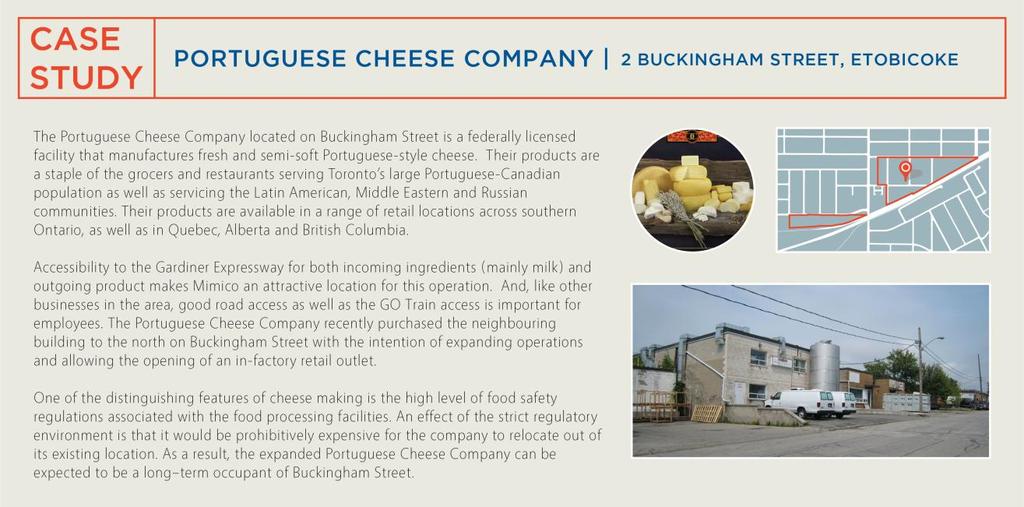
60 Attachment 4: Mimico-Judson Business Case Studies 31
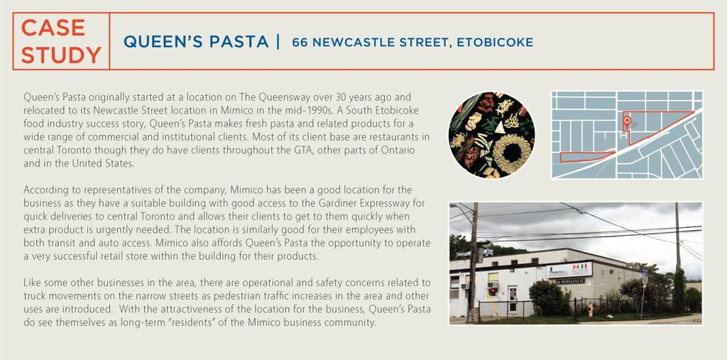
61 32
Official Plan Review: Draft Built Form Policies
 PG.30.1 REPORT FOR ACTION Official Plan Review: Draft Built Form Policies Date: May 15, 2018 To: Planning and Growth Management Committee From: Chief Planner and Executive Director, City Planning Division
Uptown Rideau Street Secondary Plan [Amendment #166, January 12, 2016]
![Uptown Rideau Street Secondary Plan [Amendment #166, January 12, 2016]](/thumbs/76/73760497.jpg "Uptown Rideau Street Secondary Plan [Amendment #166, January 12, 2016]") [Amendment #166, January 12, 2016] The policies of this Secondary Plan are in effect, save and except for the property at 560 Rideau Street, for which there remains a site specific appeal to this Secondary
[Amendment #166, January 12, 2016] The policies of this Secondary Plan are in effect, save and except for the property at 560 Rideau Street, for which there remains a site specific appeal to this Secondary
30 and 44 Zorra Street - Zoning By-law Amendment Application - Preliminary Report
 STAFF REPORT ACTION REQUIRED 30 and 44 Zorra Street - Zoning By-law Amendment Application - Preliminary Report Date: March 14, 2016 To: From: Wards: Reference Number: Etobicoke York Community Council Director,
150 Eighth Street Zoning By-law Amendment Application Preliminary Report
 REPORT FOR ACTION 150 Eighth Street Zoning By-law Amendment Application Preliminary Report Date: March 27, 2019 To: Etobicoke York Community Council From: Director, Community Planning, Etobicoke York District
Bloor St. W. Rezoning - Preliminary Report
 STAFF REPORT ACTION REQUIRED 1638-1644 Bloor St. W. Rezoning - Preliminary Report Date: April 1, 2008 To: From: Wards: Reference Number: Toronto and East York Community Council Acting Director, Community
8 Oak Street - Official Plan and Zoning By-law Amendment Application - Preliminary Report
 STAFF REPORT ACTION REQUIRED 8 Oak Street - Official Plan and Zoning By-law Amendment Application - Preliminary Report Date: March 17, 2014 To: From: Wards: Reference Number: Planning and Growth Management
The West Vaughan Employment Area Secondary Plan Policies
 Part 2: The West Vaughan Employment Area Secondary Plan Policies 2.1 General Policies It is the policy of Council: 2.1.1. That the West Vaughan Employment Area (the WVEA), identified on Schedule 1, will
and Richmond Street West - Official Plan Amendment Application - Preliminary Report
 STAFF REPORT ACTION REQUIRED 822-838 and 860-862 Richmond Street West - Official Plan Amendment Application - Preliminary Report Date: August 14, 2017 To: From: Wards: Reference Number: Toronto and East
St. Lawrence Neighbourhood Focused Area - Official Plan Amendment Status Report
 STAFF REPORT ACTION REQUIRED St. Lawrence Neighbourhood Focused Area - Official Plan Amendment Status Report Date: May 21, 2015 To: From: Wards: Reference Number: Toronto and East York Community Council
Dufferin-Wilson Regeneration Area Study City Initiated Official Plan Amendment Supplementary Report # 2
 STAFF REPORT ACTION REQUIRED Dufferin-Wilson Regeneration Area Study City Initiated Official Plan Amendment Supplementary Report # 2 Date: November 7, 2017 To: From: Wards: Reference Number: City Council
Planning and Growth Management Committee. Chief Planner and Executive Director, City Planning Division. Pg12013 (File No NNY 34 OZ)
") 865 York Mills Road Official Plan Amendment Application Preliminary Report STAFF REPORT ACTION REQUIRED Date: February 28, 2012 To: From: Wards: Reference Number: Planning and Growth Management Committee
865 York Mills Road Official Plan Amendment Application Preliminary Report STAFF REPORT ACTION REQUIRED Date: February 28, 2012 To: From: Wards: Reference Number: Planning and Growth Management Committee
South of Eastern Strategic Direction Status Update
 STAFF REPORT ACTION REQUIRED South of Eastern Strategic Direction Status Update Date: July 10, 2014 To: From: Planning and Growth Management Committee Chief Planner and Executive Director, City Planning
CONTENTS 8.0 LAND USE 8.1 GENERAL LAND USE 8.2 RESIDENTIAL 8.3 MIXED USE 8.4 COMMERCIAL 8.5 EMPLOYMENT LANDS
 8-2 Land Use 8.0 LAND USE CONTENTS 8.1 GENERAL LAND USE 8.1.1 Uses provided for in all Land Use Designations 8.1.2 Uses prohibited in Hazardous Lands, Hazardous Sites and Special Policy Areas 8.1.3 Uses
DAVENPORT VILLAGE SECONDARY PLAN
 27 DAVENPORT VILLAGE SECONDARY PLAN 27. DAVENPORT VILLAGE SECONDARY PLAN 1. VISION FOR THE DAVENPORT VILLAGE SECONDARY PLAN Davenport Village, municipally known as 830, 940, 980 and 1100 Lansdowne Avenue,
Long Branch Neighbourhood Character Guidelines Final Report
 STAFF REPORT ACTION REQUIRED Long Branch Neighbourhood Character Guidelines Final Report Date: October 26, 2017 To: From: Wards: Reference Number: Etobicoke York Community Council Director, Community Planning,
QUEEN-RIVER SECONDARY PLAN
 34 QUEEN-RIVER SECONDARY PLAN 34. QUEEN RIVER SECONDARY PLAN 1. INTRODUCTION The Queen-River area is approximately 6.4 hectares and is located at the eastern edge of the Downtown as shown on Map 34-1.
Queen Street West - Zoning Amendment Application - Preliminary Report
 STAFF REPORT ACTION REQUIRED 944-952 Queen Street West - Zoning Amendment Application - Preliminary Report Date: February 6, 2013 To: From: Wards: Reference Number: Toronto and East York Community Council
Director, Community Planning, Etobicoke York District
 STAFF REPORT ACTION REQUIRED Baby Point Gates Planning Study 227-430 Jane Street, 665-685 Annette Street, 494 Armadale Avenue, 143 Evans Avenue and 502 504 Willard Avenue Status Report Date: August 11,
THE CITY OF VAUGHAN BY-LAW BY-LAW NUMBER A By-law to adopt Amendment Number 1 to the Official Plan of the Vaughan Planning Area.
 THE CITY OF VAUGHAN BY-LAW BY-LAW NUMBER 015-2014 A By-law to adopt Amendment Number 1 to the Official Plan of the Vaughan Planning Area. NOW THEREFORE the Council of the Corporation of the City of Vaughan
Tippett Road Area Regeneration Study Final Report. Planning and Growth Management Committee
 PG8.6 STAFF REPORT ACTION REQUIRED Tippett Road Area Regeneration Study Final Report Date: October 23, 2015 To: From: Wards: Reference Number: Planning and Growth Management Committee Chief Planner and
1071 King Street West Zoning Amendment Application - Preliminary Report
 STAFF REPORT ACTION REQUIRED 1071 King Street West Zoning Amendment Application - Preliminary Report Date: August 9, 2012 To: From: Wards: Reference Number: Toronto and East York Community Council Director,
646 Kingston Road - Official Plan Amendment and Zoning Amendment Applications - Preliminary Report
 STAFF REPORT ACTION REQUIRED 646 Kingston Road - Official Plan Amendment and Zoning Amendment Applications - Preliminary Report Date: December 8, 2014 To: From: Wards: Reference Number: Toronto and East
Official Plan Amendment to Further Protect Heritage Views of City Hall, Old City Hall and St. James Cathedral - Preliminary Report
 STAFF REPORT ACTION REQUIRED Official Plan Amendment to Further Protect Heritage Views of City Hall, Old City Hall and St. James Cathedral - Preliminary Report Date: June 6, 2017 To: From: Toronto and
Welcome. Walk Around. Talk to Us. Write Down Your Comments
 Welcome This is an information meeting introducing the applications for proposed redevelopment of the Yorkdale Shopping Centre site at 3401 Dufferin Street and 1 Yorkdale Road over the next 20+ years,
DRAFT Northeast Quadrant of Kipling Avenue and Highway 7 DRAFT AUGUST 29, Goals Land Use. The goals of this Plan are to:
 AUGUST 29, 2017 12.15 Northeast Quadrant of Kipling Avenue and Highway 7 12.15.1 Goals 12.15.2 Land Use The goals of this Plan are to: 12.15.2.1 General Provisions: a) Ensure the development of a compact
1.0 Purpose of a Secondary Plan for the Masonville Transit Village
 Report to Planning and Environment Committee To: Chair and Members Planning & Environment Committee From: John M. Fleming Managing Director, Planning and City Planner Subject: Masonville Transit Village
From: Director, Community Planning, Etobicoke York District
 STAFF REPORT ACTION REQUIRED 4208, 4210 and 4214 Dundas Street West - Official Plan Amendment and Zoning By-law Amendment Application - Preliminary Report Date: July 22, 2014 To: Etobicoke York Community
2450 Victoria Park Avenue Official Plan Amendment Application Preliminary Report
 STAFF REPORT ACTION REQUIRED 2450 Victoria Park Avenue Official Plan Amendment Application Preliminary Report Date: December 19, 2012 To: From: Wards: Reference Number: Planning and Growth Management Committee
8 & 10 Donalda Crescent Official Plan & Rezoning Application Final Report
 STAFF REPORT ACTION REQUIRED 8 & 10 Donalda Crescent Official Plan & Rezoning Application Final Report Date: July 26, 2010 To: From: Wards: Reference Number: Scarborough Community Council Director, Community
Eglinton Avenue East & 50 Thermos Road - Official Plan Amendment Application Preliminary Report
 STAFF REPORT ACTION REQUIRED 1966 2050 Eglinton Avenue East & 50 Thermos Road - Official Plan Amendment Application Preliminary Report Date: March 15, 2016 To: From: Wards: Reference Number: Scarborough
523, 525 and 525A Adelaide Street West - Zoning Amendment Application - Preliminary Report
 STAFF REPORT ACTION REQUIRED 523, 525 and 525A Adelaide Street West - Zoning Amendment Application - Preliminary Report Date: May 12, 2012 To: From: Wards: Reference Number: Toronto and East York Community
1296 Kennedy Road - Zoning Amendment Application - Preliminary Report
 STAFF REPORT ACTION REQUIRED 1296 Kennedy Road - Zoning Amendment Application - Preliminary Report Date: January 15, 2016 To: From: Wards: Reference Number: Scarborough Community Council Acting Director,
Queen Street East/Ashbridge Precinct Planning Study- City-Initiated Official Plan Amendment and Urban Design Guidelines Final Report
 STAFF REPORT ACTION REQUIRED Queen Street East/Ashbridge Precinct Planning Study- City-Initiated Official Plan Amendment and Urban Design Guidelines Final Report Date: December 15, 2015 To: From: Wards:
20 & 50 Ashtonbee Road, 1920 & 1940 Eglinton Avenue East, and 880, 890 & 900 Warden Avenue Zoning Amendment Application Final Report
 STAFF REPORT ACTION REQUIRED 20 & 50 Ashtonbee Road, 1920 & 1940 Eglinton Avenue East, and 880, 890 & 900 Warden Avenue Zoning Amendment Application Final Report Date: August 16, 2012 To: From: Wards:
38 Queen s University Campus Master Plan Part 1
 38 Queen s University Campus Master Plan Part 1 46 The Campus at the City Scale Chapter 4 The Campus at the City Scale 39 Queen s is an urban University centrally located in Kingston. Decisions made by
Clairtrell Area Context Plan
 Clairtrell Area Context Plan March 2005 Urban Development Services City Planning Contents 1. Introduction... 4 2. Development Structure... 6 2.1 Streets... 7 2.1.1 Sheppard Avenue and Bayview Avenue...
King-Spadina Secondary Plan Community Consultation Meeting. Michelle Knieriem, City Planner October 11, 2017
 King-Spadina Secondary Plan Community Consultation Meeting Michelle Knieriem, City Planner October 11, 2017 Agenda 6:30 Welcome 6:35 Presentation 7:15 Question and Answer Session 8:15 Closing Remarks HOW
Symington Avenue, 405 Perth Avenue and 17 Kingsley Avenue Official Plan and Zoning By-law Amendment Application Request for Direction Report
 STAFF REPORT ACTION REQUIRED 386-394 Symington Avenue, 405 Perth Avenue and 17 Kingsley Avenue Official Plan and Zoning By-law Amendment Application Request for Direction Report Date: October 25, 2017
11 Charlotte Street - Zoning Amendment and Site Plan Applications- Request for Direction Report
 STAFF REPORT ACTION REQUIRED 11 Charlotte Street - Zoning Amendment and Site Plan Applications- Request for Direction Report Date: August 19, 2011 To: From: Wards: Reference Number: Toronto and East York
and services The protection and conservation of environmentally significant and sensitive natural heritage features and functions.
 6. Land Use 6.0 Preamble A healthy and livable city is one in which people can enjoy a vibrant economy and a sustainable healthy environment in safe, caring and diverse neighbourhoods. In order to ensure
SCARBOROUGH SUBWAY EXTENSION. Scarborough Subway Extension. Final Terms of Reference
 Scarborough Subway Extension Final Terms of Reference 1 1.0 Introduction and Background 1.1 Introduction Toronto City Council recently confirmed support for an extension of the Bloor-Danforth Subway from
Edward R. Sajecki Commissioner of Planning and Building
 Corporate Report Clerk s Files Originator s Files CD.03.POR DATE: TO: FROM: SUBJECT: Chair and Members of Planning and Development Committee Meeting Date: February 27, 2012 Edward R. Sajecki Commissioner
City-initiated Official Plan Amendment for the Gooderham & Worts Special Identity Area, Triangle Lands and Portions of the West Don Lands Final Report
 STAFF REPORT ACTION REQUIRED City-initiated Official Plan Amendment for the Gooderham & Worts Special Identity Area, Triangle Lands and Portions of the West Don Lands Final Report Date: May 26, 2017 To:
Director, Community Planning, North York District
 STAFF REPORT ACTION REQUIRED Oakwood Avenue Arts District Official Plan Amendment Final Report Date: September 12, 2008 To: From: Wards: Reference Number: North York Community Council Director, Community
Yonge Street Zoning Amendment Application - Preliminary Report
 STAFF REPORT ACTION REQUIRED 341-355 Yonge Street Zoning Amendment Application - Preliminary Report Date: March 24, 2011 To: From: Wards: Reference Number: Toronto and East York Community Council Director,
Director, Community Planning, Toronto and East York District
 Lower Yonge Precinct Plan Update STAFF REPORT ACTION REQUIRED Date: October 16, 2012 To: From: Wards: Reference Number: Toronto and East York Community Council Director, Community Planning, Toronto and
FORMER CANADIAN FORCES BASE (CFB) ROCKCLIFFE SECONDARY PLAN. Official Plan Amendment XX to the Official Plan for the City of Ottawa
 ROCKCLIFFE SECONDARY PLAN. Official Plan Amendment XX to the Official Plan for the City of Ottawa") FORMER CANADIAN FORCES BASE (CFB) ROCKCLIFFE SECONDARY PLAN Official Plan Amendment XX to the Official Plan for the City of Ottawa 1 INDEX THE STATEMENT OF COMPONENTS PART A THE PREAMBLE PAGE Purpose...
FORMER CANADIAN FORCES BASE (CFB) ROCKCLIFFE SECONDARY PLAN Official Plan Amendment XX to the Official Plan for the City of Ottawa 1 INDEX THE STATEMENT OF COMPONENTS PART A THE PREAMBLE PAGE Purpose...
Figure 1- Site Plan Concept
 Figure 1- Site Plan Concept Parking will be provided underground on three levels at rate of 1.0 space/ unit; this rate includes all visitors parking. MMM Group has prepared a parking assessment (April,
599 Kennedy Road - Official Plan Amendment and Zoning Amendment Application - Preliminary Report
 STAFF REPORT ACTION REQUIRED 599 Kennedy Road - Official Plan Amendment and Zoning Amendment Application - Preliminary Report Date: March 7, 2017 To: From: Wards: Reference Number: Scarborough Community
Wellington Street West - Zoning Amendment Application - Preliminary Report
 STAFF REPORT ACTION REQUIRED 485-489 Wellington Street West - Zoning Amendment Application - Preliminary Report Date: September 26, 2016 To: From: Wards: Reference Number: Toronto and East York Community
Stanley Greene District Downsview (80 Carl Hall Road) Zoning By-law Amendment and Draft Plan of Subdivision Applications Request for Direction Report
 Zoning By-law Amendment and Draft Plan of Subdivision Applications Request for Direction Report") STAFF REPORT ACTION REQUIRED Stanley Greene District Downsview (80 Carl Hall Road) Zoning By-law Amendment and Draft Plan of Subdivision Applications Request for Direction Report Date: December 16, 2011
STAFF REPORT ACTION REQUIRED Stanley Greene District Downsview (80 Carl Hall Road) Zoning By-law Amendment and Draft Plan of Subdivision Applications Request for Direction Report Date: December 16, 2011
112 College Street Zoning Amendment Application Preliminary Report
 ~TORONTO REPORT FOR ACTION 112 College Street Zoning Amendment Application Preliminary Report Date: January 25, 2019 To: Toronto and East York Community Council From: Director, Community Planning, Toronto
Official Plan Amendment for Scarborough Rapid Transit (SRT) Extension Final Report
 Extension Final Report") STAFF REPORT ACTION REQUIRED Official Plan Amendment for Scarborough Rapid Transit (SRT) Extension Final Report Date: April 27, 2010 To: From: Wards: Reference Number: Planning and Growth Management Committee
STAFF REPORT ACTION REQUIRED Official Plan Amendment for Scarborough Rapid Transit (SRT) Extension Final Report Date: April 27, 2010 To: From: Wards: Reference Number: Planning and Growth Management Committee
240 and 242 Finch Avenue West Zoning By-law Amendment Application Preliminary Report
 REPORT FOR ACTION 240 and 242 Finch Avenue West Zoning By-law Amendment Application Preliminary Report Date: March 1, 2019 To: North York Community Council From: Director, Community Planning, North York
Broadview Avenue Zoning Amendment Application Final Report
 STAFF REPORT ACTION REQUIRED 796-802 Broadview Avenue Zoning Amendment Application Final Report Date: May 26, 2017 To: From: Wards: Reference Number: Toronto and East York Community Council Director, Community
1407 Military Trail Zoning Amendment Application Final Report
 STAFF REPORT ACTION REQUIRED 1407 Military Trail Zoning Amendment Application Final Report Date: October 17, 2013 To: From: Wards: Reference Number: Scarborough Community Council Director, Community Planning,
251 Manitoba Street- Official Plan Amendment and Zoning By-law Amendment Application- Preliminary Report
 STAFF REPORT ACTION REQUIRED 251 Manitoba Street- Official Plan Amendment and Zoning By-law Amendment Application- Preliminary Report Date: February 5, 2014 To: From: Wards: Reference Number: Etobicoke
60-64 Queen Street East and Church Street - Zoning Amendment Application - Preliminary Report
 STAFF REPORT ACTION REQUIRED 60-64 Queen Street East and 131-135 Church Street - Zoning Amendment Application - Preliminary Report Date: March 15, 2018 To: From: Wards: Reference Number: Toronto and East
4780 Eglinton Avenue West - Zoning By-law Amendment and Draft Plan of Subdivision Applications - Preliminary Report
 STAFF REPORT ACTION REQUIRED 4780 Eglinton Avenue West - Zoning By-law Amendment and Draft Plan of Subdivision Applications - Preliminary Report Date: May 29, 2014 To: From: Wards: Reference Number: Etobicoke
CP Railway Lands St. Clair Avenue West and Jane Street Official Plan Amendment and Rezoning Applications Final Report
 STAFF REPORT ACTION REQUIRED CP Railway Lands St. Clair Avenue West and Jane Street Official Plan Amendment and Rezoning Applications Final Report Date: January 25, 2008 To: From: Wards: Reference Number:
PG Phone: (416) June 2, 2016
 June 2, 2016") PG12.8.40 Phone: (416) 202-5544 Email: Greg.Percy@metrolinx.com June 2, 2016 Delivered via e-mail (c/erk@toronto.ca & uwatkis@toronto.ca) Ulli S. Watkiss, City Clerk City Clerk's Office City Hall 13th
PG12.8.40 Phone: (416) 202-5544 Email: Greg.Percy@metrolinx.com June 2, 2016 Delivered via e-mail (c/erk@toronto.ca & uwatkis@toronto.ca) Ulli S. Watkiss, City Clerk City Clerk's Office City Hall 13th
Public Open House. Overview of the Downtown Plan Official Plan Amendment April 23, 2018
 Public Open House Overview of the Downtown Plan Official Plan Amendment April 23, 2018 1 A 25-Year Plan for Downtown To ensure growth contributes positively to Toronto s Downtown as a great place to live,
ELMVALE ACRES SHOPPING CENTRE MASTER PLAN
 ELMVALE ACRES SHOPPING CENTRE MASTER PLAN Contents 1.0 INTRODUCTION... 2 2.0 LOCATION... 2 3.0 EXISTING CONTEXT... 2 4.0 VISION & GUIDING PRINCIPLES... 2 5.0 LAND USE AND BUILT FORM... 4 5.1 St. Laurent
This report presents the draft Don Mills Crossing Secondary Plan for public consultation.
 PG30.6 REPORT FOR ACTION Don Mills Crossing - Proposals Report Date: May 17, 2018 To: Planning and Growth Management Committee From: Chief Planner and Executive Director, City Planning Division Wards:
Urban Design Manual PLANNING AROUND RAPID TRANSIT STATIONS (PARTS) Introduction. Station Study Areas
 Introduction. Station Study Areas") 111111 PLANNING AROUND RAPID TRANSIT STATIONS (PARTS) Introduction The ION rapid transit system will link Waterloo, Kitchener and Cambridge through a central transit corridor (CTC). There are a number
111111 PLANNING AROUND RAPID TRANSIT STATIONS (PARTS) Introduction The ION rapid transit system will link Waterloo, Kitchener and Cambridge through a central transit corridor (CTC). There are a number
Town of Cobourg Heritage Master Plan. Statutory Public Meeting
 Town of Cobourg Heritage Master Plan Statutory Public Meeting April 25 th 2016 Presentation Overview 1. Introduction 2. Project background and schedule overview 3. Review of strategic direction content
SUBJECT: Waterfront Hotel Planning Study Update TO: Planning and Development Committee FROM: Department of City Building. Recommendation: Purpose:
 Page 1 of Report PB-23-18 SUBJECT: Waterfront Hotel Planning Study Update TO: Planning and Development Committee FROM: Department of City Building Report Number: PB-23-18 Wards Affected: 2 File Numbers:
333 College Street and 303 Augusta Avenue - Official Plan Amendment, Zoning Amendment Applications - Preliminary Report
 STAFF REPORT ACTION REQUIRED 333 College Street and 303 Augusta Avenue - Official Plan Amendment, Zoning Amendment Applications - Preliminary Report Date: March 12, 2015 To: From: Wards: Reference Number:
Avenues and Mid-Rise Buildings Study and Action Plan Supplementary Report
 STAFF REPORT ACTION REQUIRED Avenues and Mid-Rise Buildings Study and Action Plan Supplementary Date: June 1, 2010 To: From: Wards: Reference Number: Planning and Growth Management Committee Chief Planner
1 Eglinton Avenue East Zoning Amendment Application Final Report
 STAFF REPORT ACTION REQUIRED 1 Eglinton Avenue East Zoning Amendment Application Final Report Date: September 29, 2017 To: From: Wards: Reference Number: Toronto and East York Community Council Director,
KING-SPADINA SECONDARY PLAN
 16 KING-SPADINA SECONDARY PLAN 16. KING-SPADINA SECONDARY PLAN 1. INERPREAION 1.1 he lands affected by this Secondary Plan for the King-Spadina Area are shown on Map 16-1. 1.2 Where a building within a
McCowan Precinct Plan Study Background & Deliverables
 1 DRAFT & WITHOUT PREJUDICE McCowan Precinct Plan Study Background & Deliverables In September, 2011, City Planning (Scarborough District) began a study of an area within the Scarborough Centre, identified
1151 Queen Street East - Zoning Amendment Application - Preliminary Report
 STAFF REPORT ACTION REQUIRED 1151 Queen Street East - Zoning Amendment Application - Preliminary Report Date: June 12, 2018 To: From: Wards: Reference Number: Toronto and East York Community Council Acting
13 THORNHILL YONGE STREET STUDY IMPLEMENTATION CITY OF VAUGHAN OPA 669 AND TOWN OF MARKHAM OPA 154
 13 THORNHILL YONGE STREET STUDY IMPLEMENTATION CITY OF VAUGHAN OPA 669 AND TOWN OF MARKHAM OPA 154 The Planning and Economic Development Committee recommends the adoption of the recommendations contained
2370 Finch Avenue West - Official Plan and Zoning Bylaw Amendment Application Request for Interim Directions Report
 REPORT FOR ACTION 2370 Finch Avenue West - Official Plan and Zoning Bylaw Amendment Application Request for Interim Directions Report Date: June 14, 2018 To: Etobicoke York Community Council From: Director,
Bathurst Bloor Four Corners Study Official Plan Amendment and Zoning By-law Amendment Final Report
 STAFF REPORT ACTION REQUIRED Bathurst Bloor Four Corners Study Official Plan Amendment and Zoning By-law Amendment Final Report Date: November 2, 2016 To: From: Wards: Reference Number: Toronto and East
SCHEDULE 'A' TO BY-LAW as Amended by AMENDMENT NO. 90 TO THE WHITBY OFFICIAL PLAN
 SCHEDULE 'A' TO BY-LAW 6413-10 as Amended by 6553-11 AMENDMENT NO. 90 TO THE WHITBY OFFICIAL PLAN SECTION A: GROWTH PLAN CONFORMITY PURPOSE: LOCATION: BASIS: The purpose of this Amendment is to: conform
Employment and Commercial Review Analysis of Policy Directions
 Employment and Commercial Review Analysis of Policy Directions Appendix A The following analysis is town staff s response to the policy directions provided by the consultants who prepared the Employment
Pearl Street and 15 Duncan Street - Zoning Amendment Application - Request for Direction Report
 STAFF REPORT ACTION REQUIRED 150-158 Pearl Street and 15 Duncan Street - Zoning Amendment Application - Request for Direction Report Date: April 16, 2018 To: From: Wards: Reference Number: Toronto and
THE CORPORATION OF THE TOWN OF OAKVILLE BY-LAW NUMBER
 THE CORPORATION OF THE TOWN OF OAKVILLE BY-LAW NUMBER 2017-120 A by-law to adopt an amendment to the Livable Oakville Plan, Official Plan Amendment Number 20 (Downtown Oakville Growth Area) WHEREAS the
John M. Fleming Managing Director, Planning and City Planner. Old East Village Dundas Street Corridor Secondary Plan Draft Terms of Reference
 Report to Planning and Environment Committee To: From: Subject: Chair and Members Planning & Environment Committee John M. Fleming Managing Director, Planning and City Planner Old East Village Dundas Street
5959 Yonge Street Rezoning Application - Preliminary Report
 STAFF REPORT ACTION REQUIRED 5959 Yonge Street Rezoning Application - Preliminary Report Date: February 23, 2011 To: From: Wards: Reference Number: North York Community Council Director, Community Planning,
10 Park Lawn Rd - Zoning Amendment Application- Preliminary Report
 STAFF REPORT ACTION REQUIRED 10 Park Lawn Rd - Zoning Amendment Application- Preliminary Report Date: March 9, 2012 To: From: Wards: Reference Number: Etobicoke York Community Council Director, Community
Eglinton Connects Planning Study Phase 1 (Part 2) Implementation Report
 Implementation Report") STAFF REPORT ACTION REQUIRED Eglinton Connects Planning Study Phase 1 (Part 2) Implementation Report Date: July 24, 2014 To: From: Planning and Growth Management Committee Chief Planner and Executive Director,
STAFF REPORT ACTION REQUIRED Eglinton Connects Planning Study Phase 1 (Part 2) Implementation Report Date: July 24, 2014 To: From: Planning and Growth Management Committee Chief Planner and Executive Director,
280 Manse Road - Official Plan Amendment, Zoning Amendment, Draft Plan of Subdivision Applications - Preliminary Report
 STAFF REPORT ACTION REQUIRED 280 Manse Road - Official Plan Amendment, Zoning Amendment, Draft Plan of Subdivision Applications - Preliminary Report Date: March 11, 2014 To: From: Wards: Reference Number:
CDAC. Update: Downtown Dartmouth Update: CDAC July 25 th Motion
 CDAC Update: Downtown Dartmouth Update: CDAC July 25 th Motion 2018-10-24 Downtown Dartmouth Plan Open House October 22, 2018 6:00 pm Open House 6:30 pm Presentation + Q&A 7:20 pm Open House 8:30 pm Close
College Street Study Official Plan Amendment Final Report
 STAFF REPORT ACTION REQUIRED College Street Study Official Plan Amendment Final Report Date: April 10, 2017 To: From: Wards: Reference Number: Toronto and East York Community Council Director, Community
844 Don Mills Road & 1150 Eglinton Avenue East - Official Plan Amendment Application - Preliminary Report
 STAFF REPORT ACTION REQUIRED 844 Don Mills Road & 1150 Eglinton Avenue East - Official Plan Amendment Application - Preliminary Report Date: July 10, 2014 To: From: Wards: Reference Number: Planning and
393, 395, 397, 399, 401 and 403 Spring Garden Avenue Official Plan and Zoning By-law Amendment Application Preliminary Report
 STAFF REPORT ACTION REQUIRED 393, 395, 397, 399, 401 and 403 Spring Garden Avenue Official Plan and Zoning By-law Amendment Application Preliminary Report Date: March 29, 2010 To: From: Wards: Reference
4121 Lawrence Avenue East Rezoning Application Preliminary Report
 STAFF REPORT ACTION REQUIRED 4121 Lawrence Avenue East Rezoning Application Preliminary Report Date: October 11, 2011 To: From: Wards: Reference Number: Scarborough Community Council Director, Community
[PLANNING RATIONALE] For Site Plan Control and Lifting of Holding Zone By-Law 101 Champagne Avenue. May 23, 2014
![[PLANNING RATIONALE] For Site Plan Control and Lifting of Holding Zone By-Law 101 Champagne Avenue. May 23, 2014](/thumbs/75/71599615.jpg "[PLANNING RATIONALE] For Site Plan Control and Lifting of Holding Zone By-Law 101 Champagne Avenue. May 23, 2014") [PLANNING RATIONALE] For Site Plan Control and Lifting of Holding Zone By-Law 101 Champagne Avenue May 23, 2014 Contents 1.0 Introduction... 2 2.0 Site Context... 2 2.1 Adjacent Uses... 2 Figure 1: Site
[PLANNING RATIONALE] For Site Plan Control and Lifting of Holding Zone By-Law 101 Champagne Avenue May 23, 2014 Contents 1.0 Introduction... 2 2.0 Site Context... 2 2.1 Adjacent Uses... 2 Figure 1: Site
1120 Haist Street - Pelham Arena Community Co-Design Recommendation Report Haist Street - Pelham Arena Community Co-Design Recommendation Report
 1120 Haist Street - Pelham Arena Community Co-Design Executive Summary: In May, 2017 the Town retained the services of The Planning Partnership to undertake a community design charrette process to determine
The application was submitted on March 28, A notice of complete application with regard to the application was issued on April 26, 2018.
 REPORT FOR ACTION 1800-1818 St. Clair Avenue West and 383-425 Old Weston Road Official Plan and Zoning By-law Amendment Application Request for Interim Directions Report Date: May 16, 2018 To: Etobicoke
Director, Community Planning, Toronto and East York District
 STAFF REPORT May 30, 2006 To: From: Subject: Toronto and East York Community Council Director, Community Planning, Toronto and East York District Request for Direction Report OPA & Rezoning Application
1197 The Queensway and 8 Zorra Street - Zoning By-law Amendment Application Request for Direction Report
 REPORT FOR ACTION 1197 The Queensway and 8 Zorra Street - Zoning By-law Amendment Application Request for Direction Report Date: December 14, 2018 To: Etobicoke York Community Council From: Director, Community
1285 Queen Street East - Zoning Amendment Application - Request for Direction Report
 STAFF REPORT ACTION REQUIRED 1285 Queen Street East - Zoning Amendment Application - Request for Direction Report Date: June 14, 2018 To: From: Wards: Reference Number: Toronto and East York Community
CHAIR AND MEMBERS PLANNING & ENVIRONMENT COMMITTEE JOHN M. FLEMING MANAGING DIRECTOR, PLANNING AND CITY PLANNER
 TO: FROM: SUBJECT: CHAIR AND MEMBERS PLANNING & ENVIRONMENT COMMITTEE JOHN M. FLEMING MANAGING DIRECTOR, PLANNING AND CITY PLANNER APPLICATION BY: THE CORPORATION OF THE CITY OF LONDON OUTDOOR PATIOS IN
Richmond Street West - Zoning Amendment Application - Request for Direction Report
 STAFF REPORT ACTION REQUIRED 451-457 Richmond Street West - Zoning Amendment Application - Request for Direction Report Date: February 2, 2018 To: From: Wards: Reference Number: Toronto and East York Community
Don Mills Crossing Study and Celestica Lands Development Application Community Meeting, Open House, and Breakout Discussions
 Consultation Summary Don Mills Crossing Study and Celestica Lands Development Application Community Meeting, Open House, and Breakout Discussions This report is not intended to provide a verbatim transcript
1-17 Anndale Drive, Bales Avenue and Glendora Avenue Zoning Amendment Application Preliminary Report
 STAFF REPORT ACTION REQUIRED 1-17 Anndale Drive, 31-35 Bales Avenue and 22-70 Glendora Avenue Zoning Amendment Application Preliminary Report Date: August 20, 2007 To: From: Wards: Reference Number: North