URBAN DESIGN BRIEF. April FREEPORT Street TOWNHOUSES. 711 FREEPORT St., LONDON
|
|
|
- Jeffery Maximillian Warren
- 6 years ago
- Views:
Transcription


1 URBAN DESIGN BRIEF April 2013 FREEPORT Street TOWNHOUSES 711 FREEPORT St., LONDON
2
3 TABLE OF CONTENTS 1.0 Land Use Planning Context pg Subject Lands... pg Proposed Development... pg Design Goals & Objectives... pg Design Response to City Documents... pg City of London Official Plan Urban Design Guidelines... pg City of London Official Plan Residential Policies... pg Hyde Park Community Plan... pg Spatial Analysis... pg Community Context - 400m... pg Community Context - 800m... pg Design Principles & Design Responses... pg Conceptual Design... pg Public Realm... pg Landscape Design. Pg. 13 LIST OF FIGURES Figure A: Map of Subject & Surrounding Lands... pg. 8 Figure B: Site Photographs Reference Map... pg. 10 Figures 1-4: Site Photographs... pg. 11 Figures 5-8: Site Photographs... pg Drawings and Plans SITE PLAN LANDSCAPE PLAN BUILDING ELEVATIONS RENDERING END UNIT ELEVATION EXAMPLE 2.4 Sustainability... pg. 14 Urban Design Brief: Proposed 87 unit Cluster Townhouse Development, Freeport Boulevard (City of London ON) i
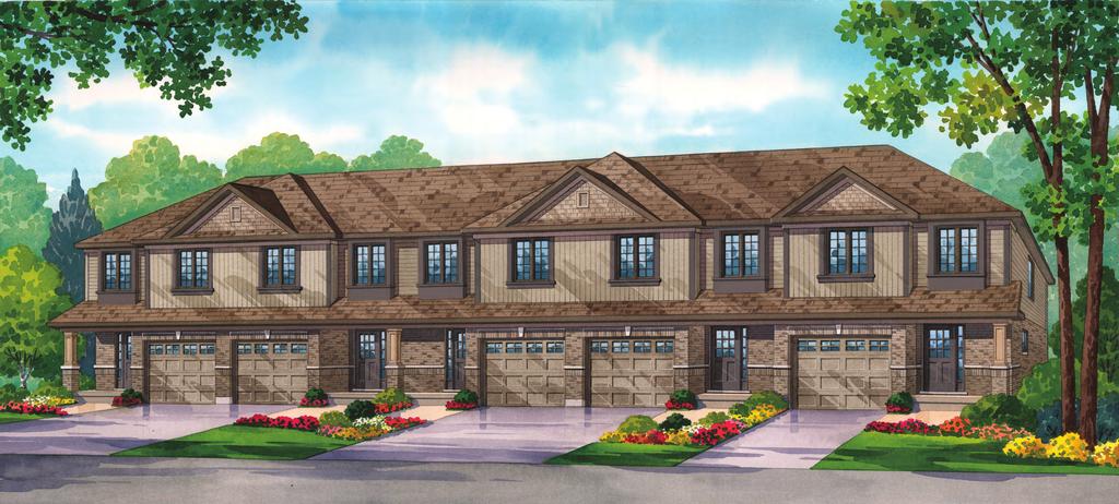
4 SECTION 1 - LAND USE PLANNING CONTEXT 1.1 Subject Lands The subject lands are located on the south side of Fanshawe Park Road West in the northwest quadrant of the City of London in a newly developing residential area which is part of the Hyde Park Community Plan. These lands are presently vacant and comprise a rectangular shaped parcel with a site area of 2.12 ha (5.24 ac), a frontage of m (541.3 ft) and a depth of m (422.2 ft). Further, the subject lands are designated for "Multi-Family Medium Density Residential" development and are correspondingly zoned Residential R5-7 and R6-5(10). R5-7 zoning is geared towards townhouses, and R6-5(10) zoning permits residential developments ranging from single detached dwellings to low-rise apartments. To the immediate north of the subject lands is a new secondary school. To the immediate west are vacant lands designated for multi-family medium and high density residential development. It should be noted that farther west at the intersection of Hyde Park Road and Fanshawe Park Road East is a "New Format Regional Commercial Node". This node is anchored by stores such as Walmart, Canadian Tire, and Winners. To the immediate east are vacant lands designated for low density residential development. Likewise to the immediate south are vacant lands and lands that are currently being developed for low density residential land uses. 1.2 Proposed Development The proposed development is an 87 unit cluster townhouse development which will be created via a standard condominium. The townhouse blocks will typically vary in size from 4 to 6 units. All blocks will have a 2 storey building height. Also, above grade wooden decks will be provided for all townhouse units to increase amenity space, and each unit will have 2 parking spaces. In addition, 21 visitor parking spaces are provided on the site. 1.3 Design Goals & Objectives The design objectives of the proposed development are to create a multi-family medium density residential development that: is in keeping with the urban design guidelines of the City of London Official Plan, and the related community and urban design guidelines of the Hyde Park Community Plan; provides an appropriate transition in built form on the south side of Fanshawe Park Road West going from high density residential development to the west to low density residential development to the east; visually enhances the existing streetscape along Fanshawe Park Road West; is sympathetic to and agreeable with the architecture of surrounding residential development; 1
5 contributes to the residential and commercial vitality of the Hyde Park community; and utilizes landscaping features to enhance the visual amenity of the site and provide appropriate screening. 1.4 Design Response to City Documents The design policies relevant to the proposed development are taken from the City of London Official Plan, as well as the design guidelines that are a part of the Hyde Park Community Plan. The subject lands are designated Multi-Family Medium Density Residential in the City of London Official Plan. Design related policies that are relevant to the proposed development are outlined below: City of London Official Plan - Urban Design Guidelines 1) iv) High Design Standards: Emphasis will be placed on the promotion of a high standard of design for buildings to be constructed in strategic or prominent locations such as within, and at the perimeter of, the Downtown, near the edge of the river valleys, or along the major entryways to the City. The proposed townhouse development is in close proximity to a "New Format Regional Commercial Node". The Hyde Park Community Plan states, "The second commercial node at the intersection of Fanshawe Park Road and Hyde Park Road will act as a gateway to the City and features a range of retail and service activity including box format retail stores." Given the importance of this node to the City, the proposed cluster townhouse development which will front on to Fanshawe Park Road West recognizes the significance of this frontage, will have a design composition and be designed with attractive materials, and will respect urban design and site plan requirements to ensure high design standards are met. 2) v) Architectural Continuity: The massing and conceptual design of new development should provide for continuity and harmony in architectural style with adjacent uses... The massing of the proposed townhouse blocks, as well as the materials which are being applied, is consistent with neighbouring residential dwellings to the south of the subject lands. The use of similar materials and harmony in architectural styles is shown in the related pictures of surrounding residences provided under the Spatial Analysis section of this Urban Design Brief. 3) x) Landscaping: Landscaping should be used to conserve energy and water, enhance the appearance of building setback and yard areas, contribute to the blending of new and existing development and screen parking, loading, garbage and service facilities from adjacent properties and streets. 2
6 As shown in the landscaping plan for the site, landscaping features have been applied throughout the site to enhance building areas and setbacks particularly facing Fanshawe Park Road. Further, landscaping has been applied to increase privacy and screen parking. 4) xi) Building Positioning: Where a proposed development consists of a grouping of buildings, the buildings should be positioned to define usable and secure open space areas on the site and to afford a reasonable measure of privacy to individual dwelling units. The layout of the cluster townhouse blocks will provide optimal privacy for residents, while delineating usable open space and maximizing the land use efficiency of the site. 5) xiii) Parking and Loading Facilities: Parking and loading facilities and driveways should be located and designed to facilitate maneuverability on site, between adjacent sites where appropriate, and to reduce the traffic flow disruption resulting from turning movements to and from the property. The road layout of the site has been designed to ensure fire route access to all buildings, and minimum traffic disruption getting to and from the site. Further, adequate parking has been provided for all residents and there is sufficient visitor parking (21 spaces) as well. In addition, the narrower, but standard 6.7m, width of the site's internal road layout acts as a traffic calming measure. 6) xv) Outdoor Space: For multiple forms of low-rise residential development, such as row housing, each unit should be provided with adequate and clearly defined outdoor living space. Clearly defined outdoor living space has been provided for each unit. Privacy fences will be installed between units and each unit will have its own above grade wooden deck which will add to the outdoor amenity space of each household. 7) xviii) Noise Attenuation: Where residential development is affected by adverse noise conditions, the use of urban design features such as building orientation, location of outdoor open space relative to the noise sources and noise attenuation measures will be encouraged subject to policy , and of this Plan. A noise study will be conducted for the proposed development. Should any units be adversely impacted by noise, appropriate attenuation measures will be undertaken in accordance with the applicable policies of the Official Plan and the Ministry of Environment (MOE). Outdoor living areas have been oriented and located away from major noise generators such as Fanshawe Park Road West. The landscaped berm along Fanshawe Park Road and the window street will also provide 3
7 noise barriers and buffer the site from Fanshawe Park Road traffic City of London Official Plan - Residential Policies With respect to the City's residential policies, the proposed development supports a number of the general residential policies of the Official Plan including: 1) Section ii) Support the provision of a choice of dwelling types according to location, size, affordability, tenure, design, and accessibility so that a broad range of housing requirements are satisfied. 2) Section iii) Support the distribution of a choice of dwelling types by designating lands for a range of densities and structural types throughout the City. 3) Section v) Direct the expansion of residential development into appropriate areas according to availability of municipal services, soil conditions, topographic features, environmental constraints; and in a form which can be integrated with established land use patterns. 4) Section vii) Minimize the potential for land use compatibility problems which may result from an inappropriate mix of: low, medium and high density housing; higher intensity residential uses with other residential housing or residential and non-residential uses. 5) Section viii) Support the provision of services and amenities that enhance the quality of the residential environment. 6) Section x) Promote residential development that makes efficient use of land and services. Specific "Multi-Family Medium Density Residential" objectives met by the proposed development include: 7) Section i) Support the development of multi-family, medium density residential uses at locations which enhance the character and amenity of a residential area, and where there is safe and convenient access to public transit, shopping, public open space, recreation facilities and other urban amenities. 4
8 8) Section ii) Encourage the development of well-designed and visually attractive forms of multi-family, medium density housing. 9) Section 3.3 (Scale of Development) Development within areas designated Multi-Family, Medium Density Residential shall have a low-rise form and a site coverage and density that could serve as a transition between low density residential areas and more intensive forms of commercial, industrial, or high density residential development. In keeping with the expected scale of development for multifamily medium density residential development the proposal is in conformity with the Official Plan's height and density policies for such development which stipulate that building height and density should be no greater than 4 storeys and 75 uph respectively Hyde Park Community Plan Similarly to the Official Plan, the proposed development satisfies community and urban design guidelines of the Hyde Park Community Plan (HPCP). It should be noted, that as the proposed development will be created via a standard condominium with private roads that are typically narrower than public streets, there is no on-street parallel parking as recommended by the HPCP. Nevertheless, there is adequate parking provided on site for both residents and visitors. HPCP guidelines satisfied by the proposal are as follows: 1) 3.0 Street Network & Street Design: Buildings should be located close to the streets to enclose the street space and make a positive contribution to the liveliness of the street. Consistent street edges are encouraged with windows, doorways and activities in easy view of pedestrians. Garages should not dominate the residential streetscape and are encouraged to be sited in the side and rear yard so that windows, doors and porches become more prominent. Where garages are at the front of houses, they should be incorporated into the main mass of the house and have minimal projections. Consistent street edges will be created within the site which are easily viewable by pedestrians. Further, the creation of a "window" road facing Fanshawe Park Road will ensure that the site is viewable from Fanshawe Park Road and contributes visual amenity to the public realm. In addition, the garages for each unit will be incorporated into the main mass of each building thereby avoiding projections that focus on the garages. 2) 3.1 Street Network Guidelines:.4) Pedestrian connections should be provided along streets, and through mid block pedestrian walkways where pedestrian connections are not possible along streets. Sidewalks have been provided within the site to ensure there are opportunities for pedestrians to safely and easily move around the site and connect to adjacent streets. 5
9 .7) Narrow streets, traffic circles and other traffic calming techniques should be incorporated into the neighbourhood street network. The design of these elements should have regard for traffic movement, including transit buses and emergency vehicles as well as pedestrian movements as part of the detailed engineering design. The internal road layout has been designed to ensure that there is appropriate traffic movement for a residential area of this nature. The travelled portion of the street will be 6.7m wide acting as traffic calming measure, but the internal road will also accommodate emergency vehicles. There will be an uninterrupted fire route meeting Ontario Building Code (OBC) standards within the site allowing emergency vehicle access to all buildings..8) Design of the street network should have regard to capturing existing views and vistas and creating new vistas. The design of the internal road layout defines a number of new vistas for the site for both north-south and east-west fields of view. Most importantly, the site will be visually connected to the public realm of Fanshawe Park Road. 3) 3.2 General Streetscape Guidelines: As illustrated in the proposed site plan and building elevations, the proposal is able to satisfy all general streetscape guidelines of the HPCP which are as follows:.1) Buildings should generally be oriented to the street to define the public space of the streets and achieve a more urban development character. In some circumstances, prominent public buildings could be setback from the street to create public open spaces..2) Reverse lotting should be avoided along all streets..3) Garages and blank walls should not dominate the streetscape..4) The design of buildings and structures located at the termination of a street and corner buildings should take advantage of the prominent location..5) A consistent building wall and roof plane should be created along view corridors to focus vistas and create perspective in the landscape..6) Sidewalks should be provided along one side or both sides of the street, as per City policy..7) Utility poles, lights, signs and other vertical elements should be located along the same planting line as street trees wherever possible to create a continuous street edge..8) Landscape design should compliment and unify other urban design objectives including building form, pedestrian and vehicular access points, parking location and signage. Berms 6
10 should generally be avoided as they do not promote the desired urban streetscape characteristics..9) Hydro service and other utilities should be located underground to minimize streetscape clutter. Where above ground services are unavoidable, consideration should be given to the location, design and screening of these structures to minimize visual clutter. 1.5 Spatial Analysis As was mentioned earlier, the site is within the Hyde Park Community Plan area which is a newly developing region of the City. The proposal is in keeping with the City of London Zoning By-law, and is conformity with the City of London Official Plan, and as such, has directly followed the City's preference of establishing multifamily medium density housing in this specific area. Such a development is respectful of surrounding residential, institutional, and commercial land uses which are also being developed in accordance with the Land Use Schedule of the City of London Official Plan. A map showing the subject lands and surrounding land uses within a 400m and 800m radius is provided below (Figure A). It should be noted that some of the new development south and north of subject lands is not shown in Figure A given the recency of the development. However, pictures from a site visit of the subject lands are also provided in this section. In addition, the Official Plan land use schedule map of the area is included in the appendices. 7

11 Figure A: Map of Subject & Surrounding Lands (Google Earth, 2013) 8
12 1.5.1 Community Context - 400m The subject lands are directly along Fanshawe Park Road West (Figures 1 and 2). The residential lands to the east and west of the subject lands are vacant and undeveloped at this time. However, there is a new secondary school directly across Fanshawe Park Road from the subject lands (Figure 4). To the south is a new low density residential subdivision (Figures 5-8). The east edge of the New Format Regional Commercial Node is just within 400m of the subject lands (Figure 3) Community Context - 800m Figure 5 - north to south View Tansbury Street and Freeport Street intersection Figure 6 - Springwood Crescent dwellings backing on to Freeport Street Figure 7 - Blackacres Boulevard dwellings south of Tansbury Street and Freeport Street intersection Figure 8 - Lands south of subject lands and new residential development along Blackacres Boulevard There is a continuation of similar land uses moving from the 400m to 800m area. With the exception of the New Format Regional Commercial Node which will serve residents of the subject lands, at this time, the majority of surrounding lands are undeveloped residential lands. In addition, Jaycee Park is shown to be within 800m of the subject lands. It is evident that a pedestrian connection from the site to Fanshawe Park Road would be advantageous for allowing residents access to the services and amenities of the area. Images of the site and surrounding land uses based on a site visit to the subject lands in March 2013 are provided next. A brief outline of each image is as follows: Figure 1 - subject lands and residential development to the south Figure 2 - frontage of subject lands along Fanshawe Park Road Figure 3 - Fanshawe Park Road west of subject lands Figure 4 - new secondary school north of subject lands 9

13 Figure B: Site Photographs Reference Map (City of London, 2013) 10


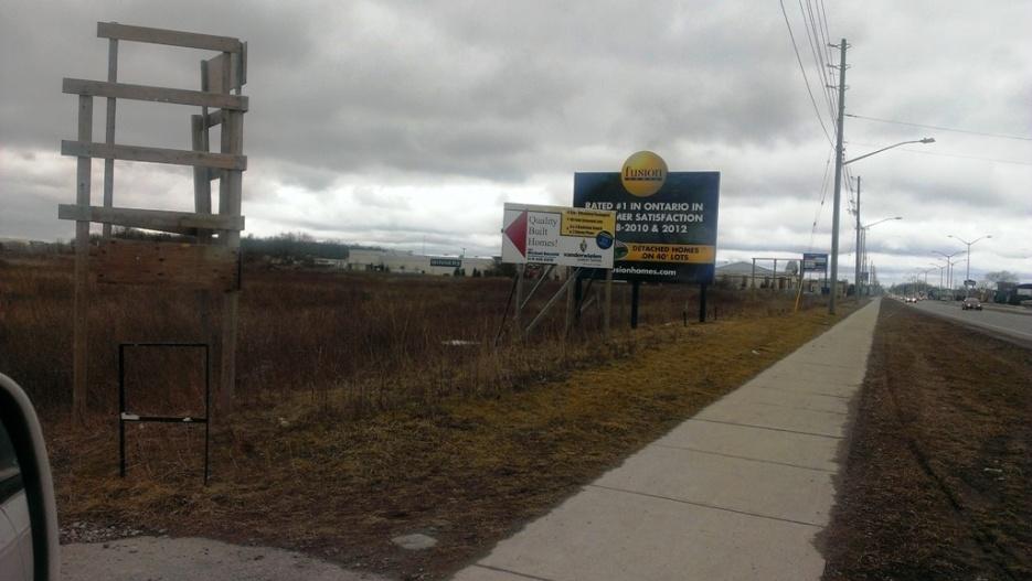
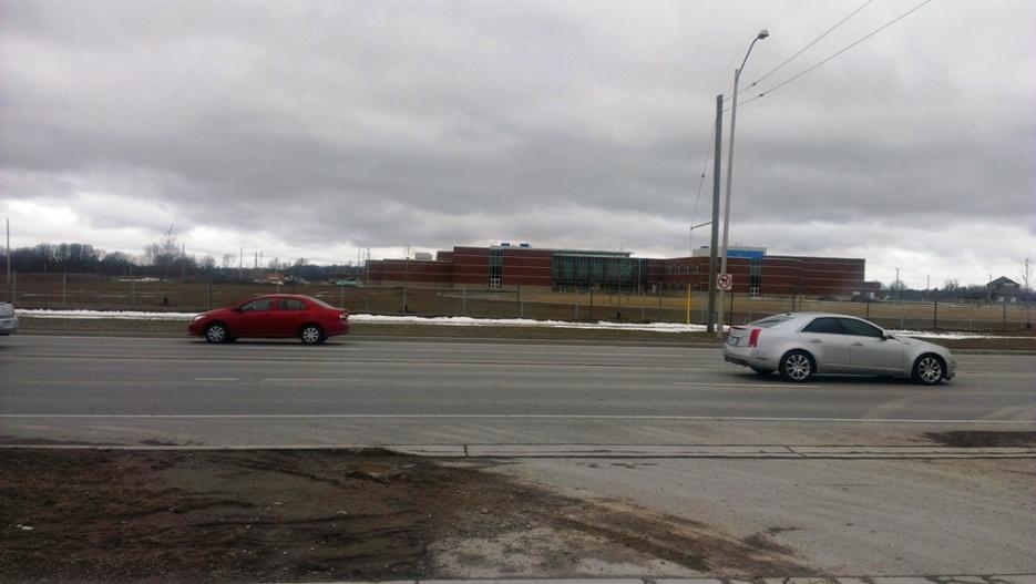
14 Figure 1 Figure 3 Figure 2 Figure 4 11


15 Figure 5 Figure 7 Figure 6 Figure 8 12
16 SECTION 2 - DESIGN PRINCIPLES & DESIGN RESPONSES 2.1 Conceptual Design In addition to the design objectives stated earlier, the design of the proposed cluster townhouse development is intended to: provide attractive and affordable housing that supports the planned commercial growth and public transit for the area; transition from lower density residential land uses to the south and east to institutional uses to the north, and higher density and commercial land uses to the west; create residential densities that efficiently use land, resources, and infrastructure; promote healthy neighbourhoods and walkability through the provision of sidewalks and connections to the larger community; and encourage the desirable growth of the Hyde Park Community. While being a higher density development in a growing area of the City which utilizes conventional materials such as brick, siding, and asphalt shingles, the proposed residential development will create a quality and visually appealing residential environment for residents of the townhouse complex. The choice and colour of materials used are similar to dwellings south of subject lands which have seen a strong market uptake and are appropriate for the building types proposed as well as the scale of the development. Also, the massing and scale of the proposed development remains at a comfortable 2-storey "human" scale which is compatible with the surrounding low density residential land uses. The proposed development recognizes the importance of the public realm and in turn will ensure a consistent and visually pleasing street wall for pedestrians through the use of appropriate buildings setbacks, functional and aesthetic landscaping, avoiding garage projections, and utilizing suitable detailed design elements (particularly for end/corner units). The overall layout of the site will successfully integrate the development with surrounding land uses. As the area matures, it is expected that the proposed cluster townhouse development will become increasingly integrated in the larger community as the area attains more urban qualities. 2.3 Landscape Design The proposed landscape incorporates several planting applications in response to the context, spatial conditions and aesthetic requirements. A variety of suitable deciduous street tree species of a medium size are proposed along the interior roadways while a large species that is extremely tolerant of harsh urban conditions defines the complex along Fanshawe Park Road. Clusters of evergreen coniferous trees anchor the corners of the site offering contrasting and defining features. Large and medium deciduous trees in various arrangements are proposed amidst the backyards to provide shade and partial screening. The window street condition along Fanshawe Park Road is to be planted with a continuous planting bed composed of shrubs and ornamental grasses. Linear planting beds of low flowering deciduous shrubs anchor the ends of 13
17 the buildings and buffer and soften the parking areas. The front foundation planting beds for all units are to have the same composition and layout with a combination of perennials, shrubs and ornamental grasses. Privacy from the dwelling outdoor living areas has been addressed. Within the development the grades are similar and appropriate patio, screening and landscaping will afford sufficient privacy. For the rows of hosing along the west and east boundaries there will be a grade difference such that the townhouse units will have walkout basements. In these units, decks will be built on the main floors to provide outdoor living areas. Over viewing into rear-yards of future adjacent single detached dwellings will be mitigated through the depth of the deck, 1.2 m high railings and large trees planted in the rear-yard, in addition to the boundary wooden privacy fence of 1.8 m in height,. 2.2 Public Realm As mentioned above, the public realm of the site will be of a high quality for residents of the site. The application of sidewalks, landscape features, and also privacy fences will allow residents to enjoy outdoor amenity space while maintaining their individual privacy. The use of a window road and generous landscaping along the front of the subject lands will significantly enhance the public realm interface along Fanshawe Park Road, and maintains both a visual and physical connection to the larger community. The northsouth and east-west vistas created by the grid-like private road network simulates a tight woven residential neighbourhood.. A number of environmental and sustainability measures are being considered for the proposed development. The most feasible measures include: water efficient landscaping; reduce energy requirements through efficient building systems; use high-efficiency glazing; utilize recycled content in building materials (re-claimed brick, etc.); use regional materials and services; use rapidly renewable materials; use low V.O.C. emitting materials; utilize natural ventilation; exceed required indoor air quality performance; and incorporate passive design elements to decrease heating and cooling requirements. The use of a number of the aforementioned sustainability measures in conjunction with the implementation of the City's urban design and site plan standards for the proposed development will create attractive and affordable housing that is functionally, aesthetically, and environmentally of the highest quality. 2.3 Sustainability 14
18 SECTION 3 Plans and Drawings Site plan Rendering Elevations Landscape plan concept 15
19
20
21
22
23
24
LIST OF FIGURES APPENDIX. Urban Design Brief: Proposed Townhouse Development, 299 Tartan Drive (City of London ON)
") URBAN DESIGN BRIEF PROPOSED TOWNHOUSE COMPLEX 299 TARTAN DRIVE, LONDON ON December 2013 TABLE OF CONTENTS 3.0 Neighbourhood Character Statement... pg. 14 1.0 Land Use Planning Context...... pg. 1 1.1 Subject
URBAN DESIGN BRIEF PROPOSED TOWNHOUSE COMPLEX 299 TARTAN DRIVE, LONDON ON December 2013 TABLE OF CONTENTS 3.0 Neighbourhood Character Statement... pg. 14 1.0 Land Use Planning Context...... pg. 1 1.1 Subject
URBAN DESIGN BRIEF REPORT
 URBAN DESIGN BRIEF REPORT PREPARED FOR 2568401 ONTARIO INC NEW GASBAR, CONVENIENCE STORE & CARWASH DEVELOPMENT @ 1509 FANSHAWE PARK ROAD WEST LONDON, ONTARIO GAMA ENGINEERING INC. PROJECT NUMBER 1669 PREPARED
Urban Design Brief 1576 Richmond Street City of London
 Urban Design Brief City of London Treadstone Developments October 31, 2014 Urban Design Brief October 31, 2014 TABLE OF CONTENTS Page No. INTRODUCTION... 1 SECTION 1 LAND USE PLANNING CONCEPT... 1 1.1
Urban Design Brief December 23, 2015 Southside Construction Group Official Plan & Zoning By-Law Amendment
 Urban Design Brief Proposed Official Plan & Zoning By-Law Amendment 3244, 3263 and 3274 Wonderland Road South Southside Group December 23, 2015 TABLE OF CONTENTS Page No. INTRODUCTION... 1 SECTION 1 LAND
URBAN DESIGN BRIEF 305, 309, & 315 SOUTHDALE ROAD WEST LONDON ONTARIO
 URBAN DESIGN BRIEF 305, 309, & 315 SOUTHDALE ROAD WEST LONDON ONTARIO CARVEST PROPERTIES LTD. December 2013 Section 1 - Land Use Planning Context 1.1 Subject Lands The subject lands are located immediately
Urban Design Brief Fanshawe Park Road. Competition Toyota
 Urban Design Brief 1300 Fanshawe Park Road Competition Toyota May 2, 2014 TABLE OF CONTENTS Page No. INTRODUCTION... 1 SECTION 1 LAND USE PLANNING CONTEXT... 1 1.1 The Subject Lands... 1 1.2 The Proposal...
URBAN DESIGN BRIEF. 2136&2148 Trafalgar Road. Town of Oakville
 URBAN DESIGN BRIEF 2136&2148 Trafalgar Road Town of Oakville Prepared By: METROPOLITAN CONSULTING INC For 2500674 Ontario Inc November 2016 TABLE OF CONTENTS Page No. 1.0 Introduction/Description of Subject
Urban Design Brief. Watson Parkway North & Watson Road North Guelph, Ontario. Prepared by Coletara Development
 Urban Design Brief Watson Parkway North & Watson Road North Guelph, Ontario Prepared by Coletara Development December, 2013 Urban Design Brief, Coletara Development 1 Introduction This Urban Design Brief
URBAN DESIGN BRIEF URBAN DESIGN BRIEF 721 FRANKLIN BLVD, CAMBRIDGE August 2018
 URBAN DESIGN BRIEF URBAN DESIGN BRIEF 721 FRANKLIN BLVD, CAMBRIDGE August 2018 DESIGN BRIEF CONTENTS PART A 1.0 INTRODUCTION 2.0 DESCRIPTION & ANALYSIS OF SITE CONTEXT 3.0 DESIGN CONSTRAINTS AND OPPORTUNITIES
Urban Design Brief. 875 Wellington Road. Proposed One-Storey Fast Food Restaurant and Two-Storey Restaurant. Wellington Harlech Centre Inc.
 Urban Design Brief 875 Wellington Road Proposed One-Storey Fast Food Restaurant and Two-Storey Restaurant Wellington Harlech Centre Inc. Prepared By: (519) 433-7587 info@yorkdev.ca May 3 rd 2013 1 Table
Urban Design Brief to 1557 Gordon Street & 34 Lowes Road West
 Urban Design Brief 1533 to 1557 Gordon Street & 34 Lowes Road West Reid s Heritage Homes Ltd. & 883928 Ontario Ltd. and RHH Property Management Ltd. City of Guelph Zoning By-law Amendment November 2017
DRAFT Northeast Quadrant of Kipling Avenue and Highway 7 DRAFT AUGUST 29, Goals Land Use. The goals of this Plan are to:
 AUGUST 29, 2017 12.15 Northeast Quadrant of Kipling Avenue and Highway 7 12.15.1 Goals 12.15.2 Land Use The goals of this Plan are to: 12.15.2.1 General Provisions: a) Ensure the development of a compact
Urban Design Brief Woodland Cemetery Funeral Home 493 Springbank Drive
 Urban Design Brief Woodland Cemetery Funeral Home The Incorporated Synod of the Diocese of Huron April 15, 2016 Urban Design Brief April 15, 2016 TABLE OF CONTENTS Page No. INTRODUCTION... 1 SECTION 1
GUIDELINES REPLACEMENT HOUSING GUIDELINES LOCATION INTRODUCTION URBAN DESIGN GUIDELINES
 Replacement housing in the former City of North York will be consistent with the following urban design guidelines. They provide a framework for residential re-development in the former City of North York
Urban Design Brief. 583, 585 and 589 OXFORD STREET EAST. Salt Clinic Canada Inc.
 Urban Design Brief 583, 585 and 589 OXFORD STREET EAST Salt Clinic Canada Inc. February 3, 2013 TABLE OF CONTENTS Page No. INTRODUCTION... 1 SECTION 1 LAND USE PLANNING CONCEPT... 1 1.1 The Subject Property...
URBAN DESIGN BRIEF.. on behalf of the owner..sunningdale Commercial Inc.
 URBAN DESIGN BRIEF.. on behalf of the owner..sunningdale Commercial Inc.. in support a Site Plan Approval Application to permit a Shopping Areas commercial centre. at 1830 Adelaide Street North, in the
MULTIFAMILY RESIDENTIAL DESIGN PRINCIPLES Site Plan and Design Review Principles Checklist
 MULTIFAMILY RESIDENTIAL DESIGN PRINCIPLES Site Plan and Design Review Principles Checklist Applicant s Name: Project Address: Phone: Email: Applicant shall fill out the design guidelines checklist for
Tel: (705) Fax: (705)
 Fax: (705)") 521 and 525 Essa Road City of Barrie Tel: (705) 812-3281 Fax: (705) 812-3438 Email: INFO@IPSCONSULTINGINC.com 1 5 0 D U N L O P S T R E E T E A S T, S U I T E 2 0 1, B A R R I E O N T A R I O L 4 M 1 B
521 and 525 Essa Road City of Barrie Tel: (705) 812-3281 Fax: (705) 812-3438 Email: INFO@IPSCONSULTINGINC.com 1 5 0 D U N L O P S T R E E T E A S T, S U I T E 2 0 1, B A R R I E O N T A R I O L 4 M 1 B
4.0 Design Guidelines For The Village Centre. South fields Community Architectural Design Guidelines Town of Caledon
 4.0 Design Guidelines For The Village Centre 4.0 Design Guidelines for the Village Centre The Village Centre is the focal point of the entire South Fields Community and is designed as a traditional commercial
Housing and Coach House Guidelines - Ladner
 Housing and Coach House Guidelines - Ladner Policy D.8: Encourage Compatible Housing Design Encourage housing design that is sensitive to existing single family housing neighbourhoods by requiring a design
AIRPORT BUSINESS PARK
 PIER MAC PETROLEUM INSTALLATION LTD. AIRPORT BUSINESS PARK DEVELOPMENT APPLICATIONS March 2003 4.1 Airport Business Park Development Permit Area 4.1.1 Justification/Design Concept The design concept envisioned
Complete Neighbourhood Guidelines Review Tool
 Complete Neighbourhood Guidelines Review Tool Prepared By: City of Regina Planning Department October 2014 Page 1 of 14 Community Development Review Checklist for Secondary Plans and Concept Plans The
Urban Design Manual 2.0 DRIVE-THROUGH FACILITIES. Background. Urban Design Challenges
 222221 2.0 DRIVE-THROUGH FACILITIES Background In recent years, drive-through facilities have grown significantly in popularity with drive-through restaurants, in particular, being established on numerous
East Bayshore Road Neighbourhood
 East Bayshore Road Neighbourhood Northridge Property Management Urban Design Brief 3195 East Bayshore Road City of Owen Sound January 2016 East Bayshore Road Neighbourhood Northridge Property Management
FLORIN ROAD CORRIDOR Site Plan and Design Review Guidelines Checklist
 FLORIN ROAD CORRIDOR Site Plan and Design Review Guidelines Checklist Applicant s Name: Project Address: Phone: Email: Applicant shall fill out the design guidelines checklist for all guidelines applicable
Proposed for Vic West Neighbourhood Plan. Design Guidelines for Intensive Residential Development - Townhouse and Attached Dwelling
 Proposed for Vic West Neighbourhood Plan Design Guidelines for Intensive Residential Development - Townhouse and Attached Dwelling Design Guidelines for Intensive Residential Development - Townhouse and
420 FANSHAWE PARK ROAD EAST London, ON
 420 FANSHAWE PARK ROAD EAST London, ON URBAN DESIGN BRIEF, CHARACTER STATEMENT & COMPATIBILITY REPORT April 2016 Prepared by MHBC Planning 630 COLBORNE STREET SUITE 202 LONDON, ON N6B 2V2 TABLE OF CONTENTS
5.1 Site Plan Guidelines
 5. Community Core Guidelines Development of the Community Core will take place by plan of subdivision and site plan approval. It will occur in a phased manner that will reflect the timing of residential
URBAN DESIGN BRIEF 181 Burloak Drive, Oakville
 URBAN DESIGN BRIEF 181 Burloak Drive, Oakville February 2017 Our File: 1730B 230-7050 WESTON ROAD / WOODBRIDGE / ONTARIO / L4L 8G7 / T: 905 761 5588/ F: 905 761 5589/WWW.MHBCPLAN.COM TABLE OF CONTENTS
Wide asphalt driveway abutting school property. garage built with incompatible materials, too close to park. incompatible fencing materials
 Wide asphalt driveway abutting school property incompatible fencing materials garage built with incompatible materials, too close to park Lack of plantings as a buffer between private property and open
Multi family Residential Development Permit Area
 City of Kamloops KAMPLAN Multi family Residential Development Permit Area PURPOSE The purpose of this Development Permit Area (DPA) is to establish objectives and provide guidelines for the form and character
PLANNING JUSTIFICATION REPORT
 PLANNING JUSTIFICATION REPORT 55 DELHI STREET CITY OF GUELPH PREPARED FOR: VESTERRA PROPERTY MANAGEMENT PREPARED BY: LABRECHE PATTERSON & ASSOCIATES INC. SCOTT PATTERSON, BA, CPT, MCIP, RPP PRINCIPAL,
178 Carruthers Properties Inc.
 178 Carruthers Properties Inc. Planning Rationale for 178 Carruthers Avenue Site Plan Control Application June 2014 Table of Contents 1.0 Introduction 2.0 Overview of Subject Property 3.0 Current Zoning
TABLE OF CONTENTS 1.0 INTRODUCTION... 3
 TABLE OF CONTENTS 1.0 INTRODUCTION... 3 1.1. BACKGROUND... 3 1.2. THE PROPOSAL... 5 2.0 EXISTING POLICY FRAMEWORK... 5 2.1. PROVINCIAL POLICY STATEMENT (PPS)... 5 2.2. CITY OF LONDON OFFICIAL PLAN (OP)...
Urban Design Brief Proposed Residential Development 5219 Upper Middle Road City of Burlington
 Urban Design Brief Proposed Residential Development 5219 Upper Middle Road City of Burlington Prepared by Weston Consulting Prepared for BLOOMFIELD DEVELOPMENT INC. Date: March 2017 Table of Contents 1.
B L A C K D I A M O N D D E S I G N G U I D E L I N E S for Multi-family Development
 B L A C K D I A M O N D D E S I G N G U I D E L I N E S for Multi-family Development Adopted June 18, 2009 This section of the Design and focuses on site planning and design guidance for new multi-family
KEY MAP DEVELOPMENT PERMIT AREA MAP. Sunnymede North Sub-Area Plan
 Richmond Official Community Plan BROADMOOR AREA SUNNYMEDE NORTH SUB-AREA PLAN Bylaw 7100 Schedule 2.6C SUNNYMEDE NORTH SUB-AREA PLAN SUNNYMEDE NORTH SUB-AREA PLAN SUNNYMEDE NORTH SUB-AREA PLAN KEY MAP
URBAN DESIGN BRIEF New Street Burlington, ON
 3225-3237 New Street Burlington, ON MARCH 2017 Prepared for: Royal Living Development Group Inc. Prepared by: adesso design inc. 218 Locke Street South, 2nd Floor Hamilton, ON L8P 4B4 t. 905.526.8876 3225-3237
URBAN DESIGN BRIEF NORTHVIEW FUNERAL HOME HIGHBURY AVE N, LONDON, ON
 URBAN DESIGN BRIEF NORTHVIEW FUNERAL HOME - 1490 HIGHBURY AVE N, LONDON, ON 1.1Purpose The intent of the following report is to identify an opportunity for redevelopment of two residential properties within
CONTENTS 8.0 LAND USE 8.1 GENERAL LAND USE 8.2 RESIDENTIAL 8.3 MIXED USE 8.4 COMMERCIAL 8.5 EMPLOYMENT LANDS
 8-2 Land Use 8.0 LAND USE CONTENTS 8.1 GENERAL LAND USE 8.1.1 Uses provided for in all Land Use Designations 8.1.2 Uses prohibited in Hazardous Lands, Hazardous Sites and Special Policy Areas 8.1.3 Uses
Regency Developments. Urban Design Brief. Holyrood DC2 Rezoning
 Regency Developments Urban Design Brief Holyrood DC2 Rezoning Stantec Consulting Ltd. 7-31-2017 1. Overview Regency Developments intends to rezone the lands located at 8510 and 8511 93 Avenue, within the
URBAN DESIGN + ARCHITECTURAL CONTROL GUIDELINES
 Appendix I BRESLAU SETTLEMENT PLAN URBAN DESIGN + ARCHITECTURAL CONTROL GUIDELINES Table of Contents 1.0 INTRODUCTION 1 2.0 DESIGN GUIDELINES FOR THE PUBLIC REALM 2 2.1 General Design Principles 2 2.2
4. INDUSTRIAL 53 CASTLE ROCK DESIGN
 4. INDUSTRIAL 53 CASTLE ROCK DESIGN CASTLE ROCK DESIGN 54 4. INDUSTRIAL Overview Well-designed and attractive industrial centers are the product of blending economic realities with both functional and
4 Residential and Urban Living Zones
 4 Residential and Urban Living Zones Refer to Chapters 11 to 20 for additional rules that may apply to these zones. 4.1 OBJECTIVES AND POLICIES Objective Res1 Policy 1 Policy 2 Policy 3 Policy 4 Policy
6.0 Land Use Policies for Rural Settlements. 6.1 Rural Settlement Strategy
 6.0 Land Use Policies for Rural Settlements 6.1 Rural Settlement Strategy INTRODUCTION AMENDMENT NO. 131 PURPOSE Designated rural settlements comprise Rural Clusters, Villages and Serviced Villages as
Clairtrell Area Context Plan
 Clairtrell Area Context Plan March 2005 Urban Development Services City Planning Contents 1. Introduction... 4 2. Development Structure... 6 2.1 Streets... 7 2.1.1 Sheppard Avenue and Bayview Avenue...
Bylaw A Bylaw to amend Bylaw 12800, as amended, The Edmonton Zoning Bylaw Amendment No. 2239
 Bylaw 17672 A Bylaw to amend Bylaw 12800, as amended, The Edmonton Zoning Bylaw Amendment No. 2239 WHEREAS City Council at its meeting of February 22, 2001, gave third reading to Bylaw 12800, as amended;
Urban Design Brief. 27 Centre Street London, ON. Prepared for: The Escalade Property Corp. Box 37 Lambeth Station London ON N6P 1P9
 Urban Design Brief 27 Centre Street London, ON Prepared for: The Escalade Property Corp. Box 37 Lambeth Station London ON N6P 1P9 Prepared by: Stantec Consulting Ltd. 600-171 Queens Avenue London, ON N6A
City of Vaughan Urban Design Guidelines for Infill Development in Established Low-Rise Residential Neighbourhoods
 City of Vaughan Urban Design Guidelines for Infill Development in Established Low-Rise Residential Neighbourhoods DRAFT - September 2016 Contents 1. Introduction 1 2. Policy Context 3 3. Characteristics
2.5 Roads. Loading and service areas adjacent to Highway 401 should be screened through architectural walls and/or landscape buffer planting.
 N HIGHWAY OFF RAMP 2.5 Roads A legible road network with a clear hierarchy will help create a connected community, both within and surrounding the Milton Heights. The following section outlines the proposed
(DC1) Direct Development Control Provision DC1 Area 4
 Direct Development Control Provision DC1 Area 4") . General Purpose (DC) Direct Development Control Provision DC Area 4 The purpose of this Provision is to provide for an area of commercial office employment and residential development in support of the
. General Purpose (DC) Direct Development Control Provision DC Area 4 The purpose of this Provision is to provide for an area of commercial office employment and residential development in support of the
Policies and Code Intent Sections Related to Town Center
 Policies and Code Intent Sections Related to Town Center The Town Center Vision is scattered throughout the Comprehensive Plan, development code and the 1994 Town Center Plan. What follows are sections
Toronto Complete Streets Guidelines
 Toronto Complete Streets Guidelines 108 110 7.1 Green Infrastructure Design Principles 112 7.2 Context-Sensitive Green Streets 114 7.3 Key Green Street Elements Green infrastructure refers to natural and
II. SINGLE FAMILY RESIDENTIAL
 II. SINGLE FAMILY RESIDENTIAL Castle Rock is made up of numerous individually built houses and subdivision tracts that have been developed during the past century. Some of the tracts are diverse in architectural
FRASER LANDS CD-1 GUIDELINES (BLOCKS 68 AND 69) Adopted by City Council April 1989
 Adopted by City Council April 1989") $1 City of Vancouver Land Use and Development Policies and Guidelines Community Services, 453 W. 12th Ave Vancouver, BC V5Y 1V4 F 604.873.7344 fax 873.7060 planning@city.vancouver.bc.ca FRASER LANDS CD-1
$1 City of Vancouver Land Use and Development Policies and Guidelines Community Services, 453 W. 12th Ave Vancouver, BC V5Y 1V4 F 604.873.7344 fax 873.7060 planning@city.vancouver.bc.ca FRASER LANDS CD-1
REPORT TO THE CHIEF ADMINISTRATIVE OFFICER FROM THE DEVELOPMENT AND ENGINEERING SERVICES DEPARTMENT
 REPORT TO THE CHIEF ADMINISTRATIVE OFFICER FROM THE DEVELOPMENT AND ENGINEERING SERVICES DEPARTMENT ON DEVELOPMENT PERMIT APPLICATION NO. DPM00592 1393 9TH AVENUE/915 MCMURDO DRIVE OWNER/APPLICANT: 1393
ELMVALE ACRES SHOPPING CENTRE MASTER PLAN
 ELMVALE ACRES SHOPPING CENTRE MASTER PLAN Contents 1.0 INTRODUCTION... 2 2.0 LOCATION... 2 3.0 EXISTING CONTEXT... 2 4.0 VISION & GUIDING PRINCIPLES... 2 5.0 LAND USE AND BUILT FORM... 4 5.1 St. Laurent
[PLANNING RATIONALE] For Site Plan Control and Lifting of Holding Zone By-Law 101 Champagne Avenue. May 23, 2014
![[PLANNING RATIONALE] For Site Plan Control and Lifting of Holding Zone By-Law 101 Champagne Avenue. May 23, 2014](/thumbs/75/71599615.jpg "[PLANNING RATIONALE] For Site Plan Control and Lifting of Holding Zone By-Law 101 Champagne Avenue. May 23, 2014") [PLANNING RATIONALE] For Site Plan Control and Lifting of Holding Zone By-Law 101 Champagne Avenue May 23, 2014 Contents 1.0 Introduction... 2 2.0 Site Context... 2 2.1 Adjacent Uses... 2 Figure 1: Site
[PLANNING RATIONALE] For Site Plan Control and Lifting of Holding Zone By-Law 101 Champagne Avenue May 23, 2014 Contents 1.0 Introduction... 2 2.0 Site Context... 2 2.1 Adjacent Uses... 2 Figure 1: Site
Commercial Development Permit Area
 City of Kamloops KAMPLAN Commercial Development Permit Area PURPOSE The purpose of this Development Permit Area (DPA) is to establish objectives and provide guidelines for the form and character of commercial
*** DRAFT 2 FOR PUBLIC REVIEW ***
 6.7 The area is generally bounded by the Red Hill Valley Parkway to the west, Lake Avenue to the east, the Queen Elizabeth Way (QEW) to the north, and by the properties just south of Queenston Road to
CHAPTER FIVE COMMUNITY DESIGN
 CHAPTER FIVE COMMUNITY DESIGN CHAPTER FIVE - COMMUNITY DESIGN Assumptions Frazier Park and Lebec have historically developed according to different patterns of spatial form. While both communities are
URBAN DESIGN BRIEF Gordon Street City of Guelph. Prepared on behalf of Ontario Inc. March 25, Project No. 1507
 URBAN DESIGN BRIEF 1131 Gordon Street City of Guelph Prepared on behalf of 1876698 Ontario Inc. March 25, 2016 Project No. 1507 423 Woolwich Street, Suite 201, Guelph, Ontario, N1H 3X3 Phone (519) 836-7526
New Street Proposed Redevelopment Architecture & Urban Design Brief
 2130 2136 New Street Proposed Redevelopment Architecture & Urban Design Brief Prepared By: Cynthia Zahoruk Architect Inc. 3077 New Street, Burlington, ON, L7N 1M6 TABLE OF CONTENTS Background and Objective
New-Cast Mixed-use Development Proposal King Street West, Newcastle, Ontario
 URBAN DESIGN BRIEF New-Cast Mixed-use Development Proposal King Street West, Newcastle, Ontario TABLE OF CONTENTS: 1.0 Executive Summary 2.0 Creating Vibrant and Sustainable Urban Places: Excerpts from
DAVENPORT VILLAGE SECONDARY PLAN
 27 DAVENPORT VILLAGE SECONDARY PLAN 27. DAVENPORT VILLAGE SECONDARY PLAN 1. VISION FOR THE DAVENPORT VILLAGE SECONDARY PLAN Davenport Village, municipally known as 830, 940, 980 and 1100 Lansdowne Avenue,
EXISTING COMPREHENSIVE PLAN
 EXISTING COMPREHENSIVE PLAN Town Center Land Use Element: V. LAND USE POLICIES Town Center Mercer Island's business district vision as described in "Your Mercer Island Citizen-Designed Downtown" was an
Bel-Air Lexus Automobile Service Station
 Bel-Air Lexus Automobile Service Station Design Brief 443-447 McArthur Avenue Ottawa April 30, 2015 14-1299-MCA Site Details Application: Site Plan Control Legal Description and Municipal Addresses: 443
Westwind Developments Ltd. PIONEER LANDS AREA STRUCTURE PLAN - PROPOSED AMENDMENT
 FEBRUARY 2013 TABLE OF CONTENTS 1.0 BACKGROUND... 1 1.1 Amendment... 1 2.0 LOCATION & CONTEXT... 2 2.1 Land Ownership... 2 3.0 POLICY CONTEXT... 3 3.1 Municipal Development Plan... 3 3.2 Capital Region
URBAN DESIGN STUDY and GUIDELINES
 ALTON CENTRAL EAST COMMUNITY CITY OF BURLINGTON URBAN DESIGN STUDY and GUIDELINES Prepared by NAK DESIGN GROUP March 2004 ALTON CENTRAL EAST CITY OF BURLINGTON TABLE OF CONTENTS PART I - Alton Central
WELLINGTON STREET WEST COMMUNITY DESIGN PLAN
 36 3.CDP POLICIES 37 Wellington Street West CDP Vision Statement 38 3.1 Introduction 3.1.1 Purpose The development of buildings and public spaces is influenced by a variety of factors over time. City of
Cit of Kitchener Ur 6 an Design Manual PARTA. Desi n for _--::
 Cit of Kitchener Ur 6 an Design Manual Date PARTA Year ) Desi n for k Nodes Corridors _--:: Section Page 01 of 12 2 INTRODUCTION Purpose & Application Nodes and Corridors have been identified as key intensification
4780 Eglinton Avenue West - Zoning By-law Amendment and Draft Plan of Subdivision Applications - Preliminary Report
 STAFF REPORT ACTION REQUIRED 4780 Eglinton Avenue West - Zoning By-law Amendment and Draft Plan of Subdivision Applications - Preliminary Report Date: May 29, 2014 To: From: Wards: Reference Number: Etobicoke
Urban Design Guidelines Townhouse and Apartment Built Form
 Urban Design Guidelines Townhouse and Apartment Built Form Town of Wasaga Beach Table of Contents 1. Introduction 1.1. Purpose 1.2. Urban Design Principles 1.3. Application of Guidelines 2. Site Design,
Mark-up of the effect of the proposed Bronte Village Growth Area OPA No.18 on the text of section 24, Bronte Village, of the Livable Oakville Plan
 Mark-up of the effect of the proposed Bronte Village Growth Area OPA No.18 on the text of section 24, Bronte Village, of the Livable Oakville Plan Notes: This document is provided for information purposes
HYDE PARK COMMUNITY PLAN
 HYDE PARK COMMUNITY PLAN COMMUNITY AND URBAN DESIGN GUIDELINES December 15, 1999 Prepared By: ~ GREEN SCHEELS PIDGEON PLANNING CONSULrANTS LIMITED URBAN Table of Contents 1.0 INTRODUCTION... 1 2.0 URBAN
CONTENTS 6.1 URBAN DESIGN
 6-2 Urban Design and Sustainable Development 6.0 URBAN DESIGN AND SUSTAINABLE DEVELOPMENT CONTENTS 6.1 URBAN DESIGN 6.1.1 General Policies 6.1.2 The Public Realm 6.1.3 Streets and Blocks 6.1.4 Streetscapes
Urban Design Brief. Garden Drive Townhouse Development Matas Development Group. Oakville, Ontario
 Garden Drive Townhouse Development Matas Development Group Oakville, Ontario February 8, 2013 Urban Design and Architecture 2 Introduction This Urban Design Brief has been prepared in support of a rezoning
TRAFALGAR ROAD
 158-2192 TRAFALGAR ROAD URBAN DESIGN BRIEF PREPARED BY KLM PLANNING PARTNERS INC. FOR DUNPAR DEVELOPMENTS INC. TOWN OF OAKVILLE JUNE 2012 TABLE OF CONTENTS 1 INTRODUCTION 1.1 Project Description...1 1.1.1
Southwest Area Secondary Plan (SWAP) Concept 1 Land use Policies
 Concept 1 Land use Policies") Purpose and Use of the proposed draft land use policies: The purpose of the Secondary Plan is to establish a vision, principles and policies for the evolution of the southwest planning area to a vibrant
Purpose and Use of the proposed draft land use policies: The purpose of the Secondary Plan is to establish a vision, principles and policies for the evolution of the southwest planning area to a vibrant
PROPOSED REDEVELOPMENT OF THE GLEN ABBEY GOLF CLUB. STREETSCAPE DESIGN STUDY (excerpt from the Urban Design Brief) TOWN OF OAKVILLE.
 TOWN OF OAKVILLE.") PROPOSED REDEVELOPMENT OF THE GLEN ABBEY GOLF CLUB STREETSCAPE DESIGN STUDY (excerpt from the Urban Design Brief) TOWN OF OAKVILLE OCTOBER, 2016 for 2.4.2 STREETS Streets are the single largest component
PROPOSED REDEVELOPMENT OF THE GLEN ABBEY GOLF CLUB STREETSCAPE DESIGN STUDY (excerpt from the Urban Design Brief) TOWN OF OAKVILLE OCTOBER, 2016 for 2.4.2 STREETS Streets are the single largest component
URBAN DESIGN BRIEF. Saginaw Subdivision 124 SAGINAW PARKWAY, CAMBRIDGE OCTOBER 2015 OUR FILE 1422A
 URBAN DESIGN BRIEF Saginaw Subdivision 124 SAGINAW PARKWAY, CAMBRIDGE OCTOBER 2015 OUR FILE 1422A Contents 1.0 INTRODUCTION AND SITE DESCRIPTION... 1 2.0 MUNICIPAL DESIGN DIRECTION... 7 3.0 MASTER CONCEPT
Urban Design Manual PLANNING AROUND RAPID TRANSIT STATIONS (PARTS) Introduction. Station Study Areas
 Introduction. Station Study Areas") 111111 PLANNING AROUND RAPID TRANSIT STATIONS (PARTS) Introduction The ION rapid transit system will link Waterloo, Kitchener and Cambridge through a central transit corridor (CTC). There are a number
111111 PLANNING AROUND RAPID TRANSIT STATIONS (PARTS) Introduction The ION rapid transit system will link Waterloo, Kitchener and Cambridge through a central transit corridor (CTC). There are a number
Design Guidelines for Residential Subdivisions
 Design Guidelines for Residential Subdivisions Development Services 972-466-3225 cityofcarrollton.com This page intentionally left blank. Table of Contents Purpose... 1 Design Objectives... 1 Design Guidelines
4. DOWNTOWN AND COMMERCIAL LAND USE DESIGNATIONS
 4. DOWNTOWN AND COMMERCIAL LAND USE DESIGNATIONS 4.1. DOWNTOWN DESIGNATION The Downtown is the primary multi-functional activity centre serving the City of London and the surrounding area, comprising much
GUIDELINES. Transit Oriented Development. Approved by Edmonton City Council on February 15, 2012 in tandem with City Policy C565
 Transit Oriented Development GUIDELINES Prepared by the City of Edmonton Sustainable Development and Transportation Services Departments Approved by Edmonton City Council on February 15, 2012 in tandem
lot flankage Y street 16m 6m landscape strip for large site 3m landscape strip for small medium site
 Commercial General Commercial Objectives Create developments compatible with adjacent land uses in scale, function and character Define a consistent and attractive street edge with quality landscaping,
Community Design Plan
 Gardena General Plan 2006 Authority While the is not a required element of a General Plan, it is included because improving the community appearance and image is paramount to the overall quality of life
LIST OF TABLES, FIGURES AND APPENDICES
 LIST OF TABLES, FIGURES AND APPENDICES Chapter Page 2 INTERPRETATION FIGURE 2.1 SAMPLE AWNING...2.8 FIGURE 2.2 SAMPLE LOW-RISE APARTMENT DESIGN...2.9 FIGURE 2.3 SAMPLE DUPLEX DESIGN...2.10 FIGURE 2.4 SAMPLE
Chapter 13 Residential Areas: Appendices APPENDIX 1 Residential Areas
 Chapter 13 Residential Areas: Appendices Page 1 Chapter 13 Residential Areas: Appendices APPENDIX 1 Residential Areas Design Code for Intensive Housing INTRODUCTION DESIGN ELEMENTS A NEIGHBOURHOOD DESIGN
HIGHLAND VILLAGE GREEN URBAN DESIGN PRINCIPLES/GUIDELINES
 URBAN DESIGN GUIDING PRINCIPLES/GUIDELINES CONTEXT/CHARACTER The City of Calgary s Municipal Development Plan (MDP), Transit-Oriented Development (TOD) Policy Guidelines and Main Street/Corridor policy
WEST LOOP DESIGN GUIDELINES CHECKLIST
 WEST LOOP DESIGN GUIDELINES CHECKLIST Section 1.0 General Strategies 1.1 DESIGN EXCELLENCE: ENCOURAGE HIGH QUALITY AND INNOVATIVE DESIGN OF NEW BUILDINGS WITHIN THE WEST LOOP WITHOUT BEING PRESCRIPTIVE
Royal Thai Embassy Ottawa. Major Zoning Amendment Proposal for 180 Island Park Drive. Planning Rationale
 Royal Thai Embassy Ottawa Major Zoning Amendment Proposal for INTRODUCTION This has been prepared in support of a Major Zoning Amendment for lands located at and currently occupied by Royal Thai Embassy.
PORT WHITBY COMMUNITY
 PORT WHITBY COMMUNITY SECONDARY PLAN UPDATE COMMUNITY IMPROVEMENT PLAN URBAN DESIGN GUIDELINES September 2015 DRAFT PROPOSED AMENDMENT NUMBER # to the Whitby Official Plan PURPOSE: The intent of this Amendment
HYDE PARK COMMUNITY PLAN COMMUNITY AND URBAN DESIGN GUIDELINES December 15, 1999 Prepared By: GREEN SCHEELS PIDGEON PLANNI~N(~ CON~[JL~~\NI~ LI,\IITI.
 HYDE PARK COMMUNITY PLAN COMMUNITY AND URBAN DESIGN GUIDELINES December 15, 1999 Prepared By: GREEN SCHEELS PIDGEON PLANNI~N(~ CON~[JL~~\NI~ LI,\IITI. I~ Table of Contents 1.0 INTRODUCTION... 1 2.0 URBAN
RIVERSIDE DESIGN CD-1 GUIDELINES. Adopted by City Council August 9, 1983
 $1 City of Vancouver Land Use and Development Policies and Guidelines Community Services, 453 W. 12th Ave Vancouver, BC V5Y 1V4 F 604.873.7344 fax 873.7060 planning@city.vancouver.bc.ca RIVERSIDE DESIGN
FORMER CANADIAN FORCES BASE (CFB) ROCKCLIFFE SECONDARY PLAN. Official Plan Amendment XX to the Official Plan for the City of Ottawa
 ROCKCLIFFE SECONDARY PLAN. Official Plan Amendment XX to the Official Plan for the City of Ottawa") FORMER CANADIAN FORCES BASE (CFB) ROCKCLIFFE SECONDARY PLAN Official Plan Amendment XX to the Official Plan for the City of Ottawa 1 INDEX THE STATEMENT OF COMPONENTS PART A THE PREAMBLE PAGE Purpose...
FORMER CANADIAN FORCES BASE (CFB) ROCKCLIFFE SECONDARY PLAN Official Plan Amendment XX to the Official Plan for the City of Ottawa 1 INDEX THE STATEMENT OF COMPONENTS PART A THE PREAMBLE PAGE Purpose...
PLANNING RATIONALE FOR THE PROPOSED RIVERSIDE SOUTH ELEMENTARY SCHOOL 715 BRIAN GOOD AVENUE, OTTAWA, ON
 PLANNING RATIONALE FOR THE PROPOSED RIVERSIDE SOUTH ELEMENTARY SCHOOL 715 BRIAN GOOD AVENUE, OTTAWA, ON Conseil des écoles publiques de l'est de l'ontario (CEPEO) French Public School Board TABLE OF CONTENTS
14.0 BUILT FORM DESIGN CRITERIA
 14.0 BUILT FORM DESIGN CRITERIA CORPORATION OF THE TOWN OF CARLETON PLACE DEVELOPMENT PERMIT BY-LAW 123 124 CORPORATION OF THE TOWN OF CARLETON PLACE DEVELOPMENT PERMIT BY-LAW 14.1 MISSISSIPPI DISTRICT
RESIDENTIAL GUIDELINES CHECKLIST
 RESIDENTIAL GUIDELINES CHECKLIST The following checklist was created to provide you with an easy way to ensure that your project complies with the Residential Design Guidelines. RESIDENTIAL DESIGN GUIDELINES
599 Kennedy Road - Official Plan Amendment and Zoning Amendment Application - Preliminary Report
 STAFF REPORT ACTION REQUIRED 599 Kennedy Road - Official Plan Amendment and Zoning Amendment Application - Preliminary Report Date: March 7, 2017 To: From: Wards: Reference Number: Scarborough Community