SCHEDULE A. Town of Ponoka Municipal Development Plan. (Bylaw No )
|
|
|
- Laurence Poole
- 6 years ago
- Views:
Transcription
1 SCHEDULE A Town of Ponoka 2013 Municipal Development Plan (Bylaw No )
2 TABLE OF CONTENTS 1 INTRODUCTION OVERALL LAND USE PATTERN AND DEVELOPMENT STRATEGY ECONOMIC DEVELOPMENT AND TOURISM RESIDENTIAL DEVELOPMENT DOWNTOWN HIGHWAY COMMERCIAL DEVELOPMENT INDUSTRIAL DEVELOPMENT RECREATION, PARKS, SCHOOLS, AND CULTURE TRANSPORTATION, UTILITIES, AND ENVIRONMENTAL SERVICES HEALTH, SAFETY, AND PROTECTIVE SERVICES A COMMUNITY FOR ALL AGES REGIONAL PLANNING AND CO-OPERATION IMPLEMENTATION
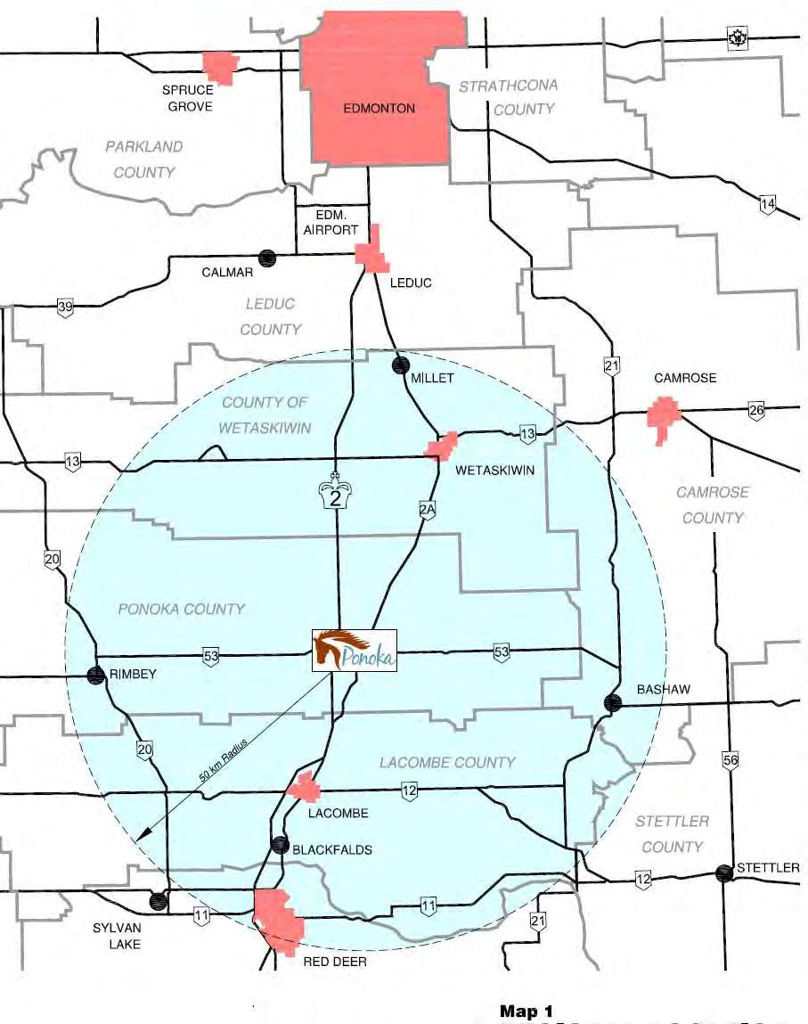
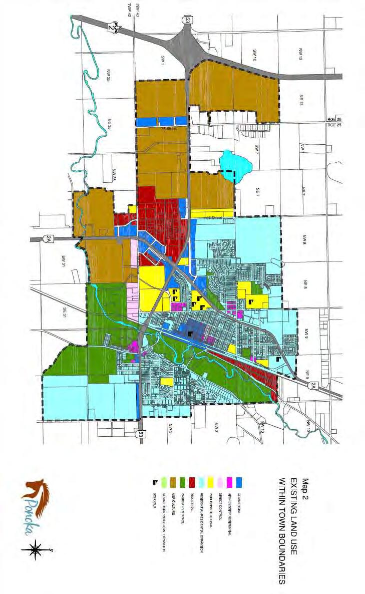
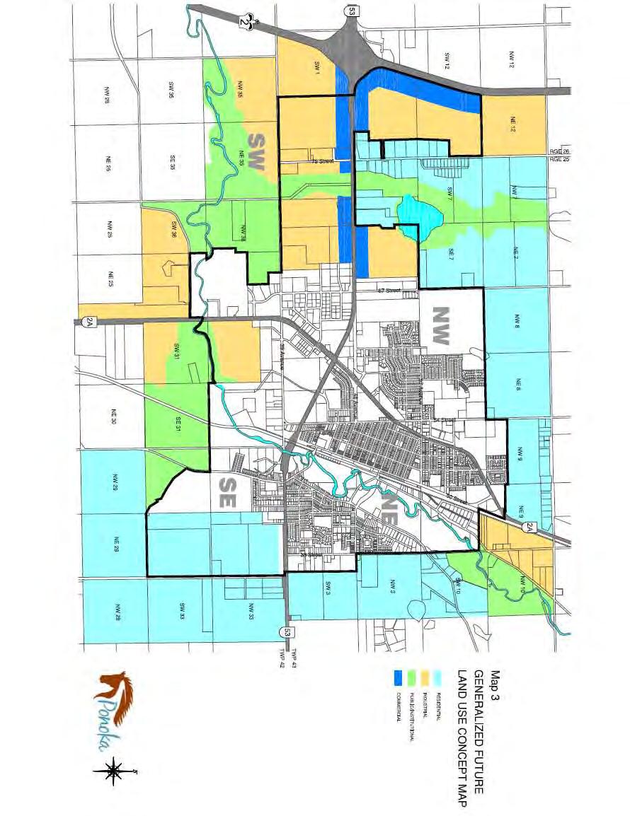
3 Maps 1 Regional location 2 Existing land use within the Town boundaries 3 Generalized future land use concept map 4 Downtown land zoning 5 Existing parks and public open areas 6 Future transportation system 7 Constraints on development 8 Development change 1997 to
4 1 INTRODUCTION The Municipal Development Plan (MDP) is the Town of Ponoka s primary land use policy statement. It directs future growth and development, ensuring orderly, economical and beneficial development while balancing the environmental, social and economic needs and desires of the community. It sets out the community s vision, goals, objectives and high level policies to guide and coordinate future urban growth decisions for the next decade. It sets forth a set of land use concepts and polices to achieve appropriate development of both public and private lands. The Plan reflects the kind of community residents wish to see in the future, and identifies ways to achieve this future while balancing growth that takes advantage of previous public investments in the community such as roads, schools and infrastructure. Not only does the Plan address land use and development; it also addresses matters related to environmental sustainability and responsibility, vitality of the local economy and the social and cultural wellbeing of its residents. The Plan is primarily a policy document that serves as a framework for the physical development of the community. It sets out how goals, plans, and policies will be implemented. It is a guide within which both public and private decision making and investment can occur, and describes what mechanisms and instruments are available to Council to implement policies contained in the Plan. It establishes a decision-making framework for determining budget priorities, and concludes by identifying the need for periodic review and amendment to maintain, update and evaluate the Plan to ensure it remains an effective, efficient planning tool that reflects changes in the Town s goals and objectives. In interpreting and implementing the Municipal Development Plan it is important to recognize that the Plan is a long-term document and that it will take many years to reach the vision it sets out. While the Plan provides a long-term context for day-to-day decision making, it is not intended to be used as a rule book or regulatory instrument like the Land Use Bylaw It requires the exercise of judgement and discretion. While the Plan is structured by topic, it is important to view the policy directions in context with one another rather than as individual parts. 4
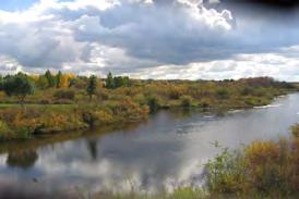
5 2 OVERALL LAND USE PATTERN AND DEVELOPMENT STRATEGY Present day land use patterns of the Town of Ponoka have been strongly influenced by the Battle River Valley, the Canadian Pacific Railway, and Highways 2 and 53. This pattern is illustrated in Map 2 - Existing Land Use within Town Boundaries. Map 3, the Generalized Future Land Use Concept Map, identifies the 2011 annexed lands and expresses the Town's current thinking about the direction of growth within its boundaries and the surrounding lands of Ponoka County. Planning within the adjacent County lands will be addressed co-operatively and as prescribed in the Inter-Municipal Development Agreement between the Town and Ponoka County. The boundaries on Map 3 provide a conceptual framework to guide future land use planning decisions. Boundaries will be set with more precision in future Area Structure Plans and by decisions of Council. Where the land uses shown on Map 3 present a conflict with existing Area Structure Plans (ASPs) or other planning and design documents, Map 3 will govern. Any ASP which conflicts with Map 3 may be amended or repealed. At this time there are no adopted Area Structure Plans that would create any land use conflicts. A number of physical and man-made features constrain the future growth and expansion of the Town because of their nature and proximity to surrounding land uses. They include features such as sewage lagoons, former sanitary landfill sites, the Battle River Valley flood plain and the Ponoka Industrial (Labrie Field) Airport. The Town s sewage lagoon is located in Ponoka County. Development limitations are necessary for the protection of the existing facility as well as ensuring a generous setback is identified that restricts any new development. This provides surety that the facility can be expanded when needed in the future. The same focus is given to former sanitary landfills. The Battle River Valley flood plain prohibits or restricts building within the Floodway zone and severely limits land use. It is an environmentally sensitive area and in need of protection and purpose responsibility. The Ponoka Industrial (Labrie Field) Airport predetermines land uses allowed in its vicinity. Factors such as limiting building height restrictions, noise setbacks, glare, and things that attract birds restrict the type of development in the vicinity of the airport. The highest volume of future expansion areas lie within the SW and NW quadrants which are the 2011 annexed areas consisting mostly of commercial and industrial uses. Given the constraints discussed above the logical and economical direction for future expansion of the Town of Ponoka is shown on Map 3 Generalized Future Land Use Concept Map. 5
6 3 ECONOMIC DEVELOPMENT AND TOURISM The Town's goal is to support economic development through the promotion and further development of the community by attracting new residents and by retaining and expanding businesses and tourism, thereby creating new jobs, attracting new investment and growing a balanced tax base. Economic development has been identified as a high priority by Council. The Town already has a diverse economic base which includes agriculture, health care, oil and gas, manufacturing, government services, and commercial and retail services. Prospective future growth industries for the Town have been identified as oil and gas, health care, value added agriculture and food processing, transportation, technology, tourism, and retirement sectors. The Town's objectives for economic development and tourism are to: promote industry clusters and their unique competitive advantages, create a healthy economic environment, provide entrepreneurial support, market remaining lands in the Southwest Industrial Park and strategically plan future industrial / commercial expansion areas, improve business development and promotions, maintain and enhance a safe and healthy living environment, increase tourism visitations and expenditures through the development and enhancement of tourism attractions, services, and infrastructure, encourage the development of assisted living facilities to meet special needs for residents of all ages, and increase community pride and positively change perceptions. To achieve this, the Town adopts the following policies. 3.1 Promote industry clusters by targeting the Town's business recruitment and support efforts primarily on value added agriculture and food processing, health care, oil and gas, transportation, and tourism sectors, emphasizing unique local conditions which create areas of specialization and provide competitive advantages in the market. 3.2 Foster a healthy economic environment by continuing to support and promote a business climate that is both open for business and competition friendly. To accomplish this, focus will be given to reducing regulatory burdens, maintaining competitive operating costs, and providing community infrastructure and amenities that ensure sustainable growth of the local economy. 6
7 3.3 Market available lands within the Southwest Industrial Park to meet the needs of light industrial and commercial growth and continue to plan other expansion growth areas suitable for these types of land uses. 3.4 Maintain a good working relationship with the Centennial Centre for Mental Health and Brain Injury (the former AHP) and continue to work with hospital administration and Alberta Health Services. 3.5 Explore opportunities for accommodation of families who have members undergoing treatment at the Centennial Centre. Potential may exist for a Ronald McDonald House style accommodation. 3.6 Promote Ponoka as a community within commuting distance for people employed within the region. Encourage those who currently commute to Ponoka for work to establish residency. 3.7 Explore opportunities to provide temporary and affordable housing. The Grant MacEwan Psychiatric Nursing Program has specifically identified this as a need. 3.8 Use regional economic development organizations such as the Central Alberta Economic Partnership and East Parkland Community Futures to stimulate both local and regional economic growth. 3.9 Support home businesses compatible with residential districts, provided they do not increase traffic volumes, affect parking, significantly change the esthetic value of the area, or negatively affect the peaceful use and enjoyment of neighbouring properties. The intent is that home businesses act as business incubators that will eventually locate to commercial and industrial areas Ponoka has developed a coordinated marketing strategy and created a marketing package to support the continued promotion of Ponoka as an attractive healthy community dedicated to the well-being of all and an affordable community in which to live Support development of the hospitality industry by ensuring potential development sites have appropriate zoning and servicing Undertake strategic long term planning for the development and promotion of Ponoka s museum and historical resources. Considerations should include the Fort Ostell Museum, Alberta Hospital Ponoka Museum Collection, Cowboy Museum, Municipal Heritage Project and the Canadian Pro Rodeo Hall of Fame Address the proposals of the Ponoka Museum and Heritage Board regarding the preservation and protection of Ponoka s heritage buildings: Set up the administrative framework with appropriate procedures for a municipal designation program in accordance with the Alberta Historical Resources Act. Integrate the inventory as a management and planning tool in town data bases and planning documents. 7
8 Support initiatives undertaken by the Fort Ostell Museum to build on research and information resulting from the inventory project to foster awareness of heritage buildings. Investigate with the appropriate bodies how previous studies and reports such as the 2007 Avi Friedman Report Retooling Downtown Ponoka could serve as an integral part of the Municipal Designation Program. The 2001 Main Street Program could also serve as a useful resource. Plan to undertake Part Two of the Inventory Project which will assess residential and other non-commercial properties in Ponoka. Utilize the Town of Ponoka Municipal Heritage Inventory Part 1 and the Statements of Significance as the foundation for next steps in the Municipal Heritage Partnership Program Support the development of tourism events and opportunities within the community Allow bed-and-breakfast accommodation as permitted or discretionary uses in owner-occupied dwellings in districts identified within the Land Use Bylaw, provided they do not unduly interfere with the amenities of the neighbourhood Create positive first impressions. Improve signage and landscaping throughout the community with emphasis on key intersections and on entrances to the community located on Highways 2, 53, and 2A; the Battle River Valley Trail System; and directional signs to downtown and the industrial areas. The 2011 First Impressions Community Exchange Final Report, 2012 Town of Ponoka Brand Strategy, and the 2007 Friedman report on downtown all offer useful ideas Work with provincial and federal departments, the Chamber of Commerce and other public and private sector groups to effectively market the Ponoka region for business development and as a tourist destination Continue to update the Town web page on a regular basis providing links and information to various business resources for both existing businesses and new entrepreneurs. The Economic Development Officer is available for additional support and information. 8
9 4 RESIDENTIAL DEVELOPMENT The Town's goal is to facilitate the creation of inclusive neighbourhoods, containing a range of housing options and related compatible uses, supporting the needs and preferences of a variety of household types and income levels. The Town's objectives for residential development are to: ensure that residential development takes place in an efficient economical, and well planned manner, encourage a wide range of residential parcel sizes, densities, and housing types, including those required to meet special housing needs, phase residential development in an orderly way to use existing infrastructure before investing in new, maximize the design quality of new residential developments and neighbourhoods, and leave residential land development generally in the hands of the private sector. Residential policies have been divided into two parts. The first part deals with new subdivisions. The second deals with the redevelopment of existing residential areas. Policies for new residential areas: 4.1 The Town will adopt an Area Structure Plan (ASP) before any large new area is approved for development. Residential ASPs should include the following design principles to ensure that new neighbourhoods are designed and developed in a manner that contributes to the health and well-being of residents including making them safe, esthetically pleasing, and well serviced: Provide curvilinear roadways based upon a grid system, to create more interesting streetscape, provide privacy, and discourage through traffic. Provide for various focal points (parks, playgrounds, schools, community facilities, and churches) within the neighbourhood to encourage cohesion and interaction. Design subdivisions so dwellings do not front onto highways and arterial roadways. Wherever possible, provide for pedestrian and bicycle paths to link residential areas with open spaces and activity nodes through parks, environmental reserves, utility lots, planned pathways, and other amenities. Wherever possible, protect environmental features such as stands of trees, water courses, wetlands, ravines, or other natural areas. 9 Create distinct neighbourhood units which discourage through traffic and are oriented inwards, away from major traffic thoroughfares.
10 10 Provide adequate parks and open spaces to service the neighbourhood. Preference will be given towards larger centralized parks which are more useable and less costly to maintain than a number of smaller dispersed tot lots. 4.2 The Town encourages developers to propose housing on narrow lots to reduce servicing costs. A mixture of lot sizes and zoning is expected in each subdivision. 4.3 If the present zoning classes do not allow what a developer wishes to build, he is encouraged to propose a new zoning class for adoption into the Land Use Bylaw. 4.4 Residential subdivisions should normally have continuous sidewalks so that pedestrians can easily reach schools, parks and amenities. 4.5 Higher density housing will be directed to places close to amenities such as major community facilities, schools, recreation, commercial areas and within the vicinity of the downtown core in close proximity to arterial and collector roadways, and where off-street parking can be provided to avoid conflicts over on-street parking 4.6 Manufactured housing parks (in which the residents rent a space) will be encouraged to expand and infill in areas designated for this purpose within an approved Area Structure Plan and/or the Land Use Bylaw. The owner of the park will continue to be responsible for the construction and maintenance of internal roads to acceptable Town standards, utilities, common areas and buildings, parks, and open spaces, including snow removal, garbage collection, and upkeep of landscaping. 4.7 Manufactured housing subdivisions (where the residents own the lot on which their unit stands) must comply with the built standards acceptable for community facilities and infrastructure at the same standard and requirement as in conventional residential subdivisions. 4.8 The Town will consider rezoning additional land to Estate Residential, which provides large lots with the conveniences of urban living, similar to that approved for Caledera, Country Hills Estates and Hudson s Green. 4.9 Estate residential developments will be subject to the following conditions. Lots must have a minimum lot size of.30 hectares (.75 acre) with a minimum frontage of 30.5 metres (100 feet). Re-subdivision will not be allowed. The development must be connected to the Town s water and systems. Failing that an underground piped internal sewage collection system with the capacity to connect to Town services when they are made available
11 may be acceptable with the submission of engineering drawings and other appropriate planning documents. This determination will be at the discretion of the Town and must be consistent with and approved by provincial regulatory authorities. Roadways must be developed to Town standards with an acceptable width carriageway paved with asphalt concrete pavement (hot mix). The Town will give consideration, at their discretion, to allowing the developer to install maintained landscaping along the road right-of-way by means of shallow ditches in place of curb and gutter. At the time of subdivision the Town will register a caveat on the property notifying future owners that upgrading or connecting to an urban standard for roadways and municipal services (sanitary and stormwater) at a later date will be at the owner s expense Group homes and special care facilities are needed to accommodate people who formerly lived in institutions. The local economy will benefit from jobs at these facilities. The Town will work with the Centennial Centre, Michener Centre, provincial health authorities, developers, and operators to determine the required size, specifications, and locations for group homes. Location criteria would be similar to those at other multi-family developments: namely, to be located in the vicinity of the downtown core; near major community facilities; in close proximity to arterial and collector roadways, recreation and commercial areas. There is potential for adaptive reuse and conversion of existing apartment blocks and upper floors of commercial buildings in the downtown core as well as the old General Hospital site The Town will identify areas where secondary suites might be allowed, what governing principles will guide development (such as parking requirements, number and size of suites per dwelling unit, specific residential districts for inclusion/exclusion) and how existing properties can be protected from any adverse impacts The Town will market land it currently owns, but does not plan to acquire new property for residential land development. Council believes residential development is best left to the private sector. However, if the private sector is unable to meet local housing needs, the Town may find it necessary to act in the public interest to ensure an adequate supply of housing is available to meet these needs. 11
12 Residential redevelopment policies: More than 700 houses in Ponoka were built before 1971, and they make up over 25% of the town's housing stock. Most of these houses are in good condition, and have many years of life remaining if their owners continue to maintain them. However, some are reaching the end of their useful life The Town will support renewal and redevelopment of older residential areas, on the understanding that Redevelopment of older areas will normally increase the density of population. Two storey construction is encouraged, and narrower lots may be created through re-subdivision. Row houses, fourplexes, and apartments may be appropriate forms of redevelopment along major roads and adjacent to schools, recreation areas, and non-residential uses. Any increase in density must take into account the need for additional offstreet parking. If existing municipal infrastructure needs to be upgraded to support a higher density of development, the cost must be borne by the developer Town staff will consult with the owners of large lots who wish to subdivide their land to normal urban densities, and advise them about the approval process The old General Hospital site is seen as a good location for comprehensive development and/or conversion of the building to a mixed use such as commercial and multiple residential or institutional uses, while the western portion of the site could be used for multiple residential purposes Sites occupied by older single-family dwellings may be considered for redevelopment to multi-family, provided this is compatible with the neighbourhood. Rezoning hearings will allow neighbours to express any concerns. Development will be also subject to the same locational considerations as for in new subdivisions The Town encourages infill of already subdivided and serviced residential areas, especially undeveloped parts of the downtown core and pre-planned areas such as Hudson s Green, Sommer Bros, Laebon, Chicken Hill, and Country Hills Estates. 12
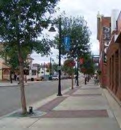
13 5 DOWNTOWN The Town's goal is to maintain the downtown core as the primary retail and commercial district for the Town and surrounding region. Downtown development and revitalization remain a priority with Council who, in recent years, have proactively undertaken studies such as the 2001 Ponoka Main Street Project and the 2007 Avi Friedman study Retooling Downtown Ponoka, Alberta to support their commitment to maintaining and revitalizing the downtown district. The challenge in revitalizing downtown is to provide a broad range of uses and alternatives that appeal to a diversity of needs and interests of the people located within its market area. Issues that need to be addressed include vacant storefronts, retail options and price points. This MDP recommends Ponoka s downtown core maintains a strong connective pedestrian environment and pursues an economic development strategy that focuses on business retention and development. The Town's objectives for downtown are to: 13 maintain its significance as a primary retail and commercial district; create a mixed use environment by making it an esthetically pleasing place to shop, work, live, and play; create a sense of place through the development of a safe, clean, and pedestrian friendly environment; support development of vacant lots; encourage the restoration and preservation of historically significant buildings; provide an adequate supply of parking for customers; attract new investment and businesses to the downtown; work in conjunction with downtown merchants to address issues such as uniform shopping hours, customer service, business streetscapes and promotions; and encourage business owners to take a proactive role in creating engaging activities, special events and entertainment opportunities in the downtown core. The Town recognizes that buildings do not revitalize downtown; people do. As people have a diversity of needs and interests, a successful downtown lies in providing a broad range of uses and attractions. The essence of downtown revitalization is to bring people downtown more often and keep them longer. (Cyril Paunier, 1988) To achieve this, the Town adopts the following policies. 5.1 Rejuvenate the downtown core through promotion and development of sustainable niche and retail businesses. The Freidman Report and the Main Street Demonstration Project will be used in the planning process. The development and implementation of streetscaping standards, consistent aesthetic protocol for store front facades and preserving the historic elements and value of our heritage buildings will be an integral part of this process.
14 Partnerships already in place such as CAEP, CAPP and the Ponoka Economic Development Board will serve as available and invaluable resource to be utilized for the benefit of rejuvenation 5.2 Explore the potential development of a Downtown Merchant Committee to work in conjunction with the Economic Development Board and the Ponoka and District Chamber of Commerce to develop and implement downtown rejuvenation strategies. 5.3 Encourage major government offices and institutional uses to stay and where possible expand downtown. 5.4 Any new municipal buildings will be located downtown unless operational requirements dictate another location. 5.5 Promote mixed use. Develop downtown as a mixed-use, multi-functional activity area containing retail, office, institutional, residential, recreation, cultural, and entertainment activities to create pedestrian traffic. 5.6 Expand the boundaries of the downtown area with the prime intention of developing a process that will see more local residents and tourists visiting and patronizing downtown. The 2007 Friedman Report addresses creating connectivity throughout the downtown core and creating linkages to the Battle River Valley for recreational opportunities. 5.7 Encourage the restoration of historic buildings through the Municipal Heritage Inventory project undertaken in 2010 in conjunction with the Ponoka Museum and Heritage Board. Develop a policy with next steps to ensure those building identified in the Inventory Project are considered for municipal designation status and are eligible to be placed on the Alberta Register of Historical Places and obtain funding through the Alberta Historical Resource Foundation. 5.8 Establish downtown design guidelines and a design review process working in collaboration with the development officer to guide decisions regarding restoration and infill development within the designated downtown core. 5.9 Increase residential density downtown. Promote multiple unit housing opportunities in and near the downtown in order to create pedestrian traffic and help augment a customer base as well as provide a variety of housing opportunities for all ages and abilities, especially seniors, needing to be close to downtown amenities. Identify, and designate in the Land Use Bylaw, sites for higher density infill housing in the Central Core area Create pedestrian and bicycle links that are safe, direct, attractive and connective that develop synergy with the Battle River Valley, the Stampede Grounds and other centres of activity as well as the downtown Pave municipal parking lots, provide landscaping and install directional signage in keeping with the newly developed brand strategy Relax and simplify downtown parking standards. Recent studies show that there is ample parking downtown. Review and amendment to the Land Use 14
15 Bylaw will ensure off-street parking spaces are addressed in the C1 Commercial District as follows: require no additional parking stalls when a development permit is issued for a change of use involving only interior alterations of the building and there is no addition or expansion of the overall square footage of the building; in cases of new construction, additions, and expansion of buildings a uniform standard will be established through the Land Use Bylaw; on the approval of the Development Officer, an owner of land or a group of such owners may pool his or their required off-street parking spaces within one or more communal parking compounds; and in the case of a heritage building, the Development Officer may use discretion regarding parking requirements Continue to address streetscape improvements in the downtown core to enhance the pedestrian environment and esthetic value of the district. The 2012 First Impressions Community Exchange Report identifies entrance and streetscape improvements areas for the community Encourage incompatible uses to move out of downtown. Some commercial ventures require larger land areas and storage space, and are better situated in a light industrial park or highway location. Nonconforming land uses will also be encouraged to relocate into appropriate zoned areas as they outgrow current locations. 15
16 6 HIGHWAY COMMERCIAL DEVELOPMENT Serving a different need than the downtown, the highway commercial areas along Highway 2A and 53 primarily accommodate auto-oriented commercial uses and the traveling public. Typical uses include hotels, motels, restaurants, gas stations, automobiles and recreational vehicle sales. Efforts will be made through development and redevelopment of highway commercial sites to improve visual quality, maintain appropriate building setbacks, improve and protect access points via internal road systems wherever possible and to not adversely affect existing adjacent land uses. The Town's goal is to maintain an adequate inventory of land for highway commercial purposes to create a vibrant and cohesive commercial sector that supports local residents and the regional market. The Town's objectives for highway commercial development are to: provide opportunities for automobile oriented commercial uses by identifying locations and policies for long term commercial development; ensure the quality and aesthetics of development along major commercial corridors; restrict individual accesses where possible to avoid impeding highway traffic; ensure sites are available for development of hotel/motel and other tourist amenities and accommodations. To achieve this, the Town adopts the following policies: 6.1 Pre-plan and designate land for highway commercial purposes within the Land Use Bylaw consistent with Map 3, Generalized Future Land Use Concept. 6.2 The Town will create comprehensive guidelines for desirable highway commercial developments for setback and access control. Design standards will be established within the Land Use Bylaw to ensure the character of commercial developments bring esthetic enhancement to the area by requiring paving of parking and loading areas, screening where appropriate, landscaping of developments and landscape buffers between uses where necessary. 6.3 Require commercial developments fronting onto highways and arterial roadways to provide access via the internal road system or other forms of shared access wherever possible. 6.4 Long range highway commercial development locations and opportunities should meet development criteria to promote, not jeopardize existing adjacent land uses. 6.5 The functional plans for Highways 2A and 53 developed by Alberta Transportation will govern all development adjacent to these highways. 16
17 7 INDUSTRIAL DEVELOPMENT The Town's goal is to ensure that there is sufficient, suitably located and serviced industrial land available, both publicly and privately, to attract and facilitate a wide range of industrial development in the future. The Town's objectives for industrial development are to: maintain and/or facilitate an adequate inventory of industrial lots, serviced where feasible, of varying lot sizes and types (light and heavy) to meet the needs of business and industry, avoid and/or mitigate conflict between industrial uses and other land uses through development of industrial areas that are functional, esthetically pleasing and minimize the negative environmental impacts often associated with industrial development, and promote development that utilizes existing municipal services in the most cost effective and efficient manner. To achieve these objectives, the Town adopts the following policies: 7.1 Continue to market the remaining lands in the South West Light Industrial Park. 7.2 Offer planning and economic development support to private developers for the remaining land within the North East Heavy Industrial Park. Ensure continued access to the Town owned railway spur line for developers and users. 7.3 Create an Area Structure Plan for a new North West Business Park in NE While most of the quarter will become light industrial, there will also be a 20 acre addition to the Forest Home Cemetery. 7.4 Work with private developers, land owners and Ponoka County to designate and pre-plan lands for light and heavy industrial purposes outside the present Town boundaries. 7.5 Set building and landscaping standards for industrial areas. This is particularly important where industrial development abuts a major roadway, residential, or park areas. The Land Use Bylaw when amended will address, among other things, siting and design of buildings, landscaping, screening of storage and parking areas, signage and intensity of development, while recognizing the industrial nature of these areas. 7.6 The Town will use the Land Use Bylaw and other planning documents to ensure appropriate separation distances and transition between industrial and nonindustrial uses. 7.7 Require commercial and/or industrial development to comply with the functional plans developed by Alberta Transportation for Highways 2A and 53. Ensure compliance with relevant municipal policies that govern access for development adjacent to internal roadways within the Town. 17
18 8 RECREATION, PARKS, SCHOOLS, AND CULTURE The Town's goal is create an integrated, accessible and well-planned system of open space, recreational and cultural facilities and parks to support a broad range of recreation and cultural opportunities catering to diverse age groups, income and skill levels. The Town's objectives for recreation, parks, schools and culture are to: provide and expand open spaces and park areas that are functional, protect natural areas and are effective in satisfying the needs of residents and visitors to the Town of Ponoka, ensure a continuous system of pathways with linkages to parks and natural areas as the Town grows, ensure development and maintenance of high quality community facilities and services and encourage the efficient and economic use of all community resources, create an action plan to effectively market existing community facilities and parks, encourage sharing and multiple use of parks and open space areas among a variety of user groups and activities, protect natural land forms and amenities, particularly the Battle River Valley, and meet established parks standards through adequate municipal reserve dedication through the subdivision process. To achieve this, the Town adopts the following policies: 8.1 The Town will determine required park space based on the priorities of the neighbourhood and the uniqueness of the community s recreational and cultural needs. When determining needs, the Town will consult but will not be bound by provincial and national standards. 8.2 The Town will ensure parks and open spaces are planned and developed in such as manner as to meet the needs of all residents at different stages of life and abilities that offer passive and active opportunities. 8.3 Establish design criteria for parks. The Town will attempt to Provide non-structured places for informal gatherings and leisure pursuits that will maximize use opportunities and justify associated development and maintenance costs. 18
19 If necessary, retrofit, existing small parks for multiple uses: o Children aged 0-5 years (tot lots) o Persons with reduced mobility o Picnicking areas o Community garden areas Ensure that all parks and open spaces are accessible by pedestrian and bicycle traffic, as well as visible and open to roadways. When new areas are developed, locate smaller parks adjacent to neighbourhood commercial areas and/ or storm water management facilities to maximize the use of protected areas with limited development capacity. Connect all parks and open spaces where possible with the Town s walkway system. Create a large multi-purpose joint use public space in the downtown to bring various segments of the community together through sports, arts, environmental, cultural and family activities, and special events. Explore opportunities for enhancing physical and visual access to the Battle River Valley. Utilize utility corridors, easements and other rights-of-way, as passive recreational linkages to existing and new open space networks and trails. 8.4 The Town will work co-operatively with school authorities in the planning and location of school sites and joint use sites. Joint use of these sites between the Town, school authorities and community organizations will be encouraged and pursued wherever practical. 8.5 Continue to work co-operatively with Ponoka County through joint use agreements to develop, maintain and enhance policies that are cost-efficient and beneficial to the public. 8.6 Reserves due upon subdivision will normally be taken in the form of land, dependent on the needs of the neighbourhood. In new residential subdivisions the Town will require 10% of the parcel being subdivided less any land dedicated as environmental reserve to be dedicated as reserve (municipal reserve, school reserve and/or municipal and school reserve) in accordance with the Municipal Government Act. The Town will encourage dedication of reserve above 10% where the additional dedication supports the provision of recreation sites and preservation of natural areas that do not meet the definition of environmental reserve. Pursuant to Section 666 of the Municipal Government Act where residential densities as result of subdivision are higher an additional 3% - 5% may be taken as prescribed in the MGA. 19
20 The Town will work co-operatively with school boards and seek their input before determining the location of municipal and/or municipal and school reserves. Commercial and industrial subdivisions will be required to dedicate only 5% of the area as municipal reserve. The reserve may be provided in the form of land, cash in lieu of land, or a combination of land and cash in lieu as determined by the Town acting as subdivision authority. Money provided in place of municipal reserve, school reserve or municipal and school reserve will be placed in a reserve fund and used for parks, recreational development, school board purposes or to separate areas of land used for different purposes consistent with Section 671 of the MGA. The Town will not accept as municipal reserve land that is more properly dedicated as environmental reserve. However, ER may be used for recreation if the intent of the MGA is met. 8.7 Land will be taken as school reserve where the school board demonstrates a need for a new school site. Failing this, all reserve land will be designated as municipal reserve, and all money in place of reserves will be paid to the Town. 8.8 Municipal and school reserves may be declared as surplus and disposed of following a public hearing. The Town or the municipality and the school board may jointly sell, lease or otherwise dispose of the land. 8.9 Sale proceeds will be used for parks and recreation purposes consistent with Section 675 of the Municipal Government Act Maintenance takes priority. The Town will remain focused on maintaining and upgrading existing facilities The Battle River valley will continue to be developed as a linear trail and park system to conserve the natural features and cultural heritage while offering compatible year round opportunities for recreation, environmental protection, and education Ensure development within the river valley provides connectivity to surrounding developments and is compatible with adjacent land uses. The Friedman Report will be used as a planning tool for identified portions of the downtown and the Battle River Valley. The Report illustrates how to effectively link pedestrian and bicycle trails to other parks and activity centres in the Town to make them more accessible and to increase public use The Battle River Water Management Plan will be an integral component in land use planning for development within the river valley Land will be acquired in the Battle River valley for environmental protection and recreational purposes by way of environmental and municipal reserve dedication, or opportunities to purchase environmentally sensitive areas in need of protection. 20
21 8.15 The Town will continue to work co-operatively with Ponoka County and community groups to develop a long range plan to facilitate the expansion and integration of the trail system throughout the Town and County with the projected outcome being to build a regional trail system connected to the Trans Canada Trail Network The Town will continue to control and restrict construction and development within the floodway and flood fringe areas as identified by Alberta Environment, Flood Management Practices, and the Land Use Bylaw An updated Recreation and Culture Master Plan is needed to address identified specific needs and concerns expressed in the 2007 Interim Needs Assessment and Feasibility Study and other studies for present and future recreation and sports facilities. 21
22 9 TRANSPORTATION, UTILITIES, AND ENVIRONMENTAL SERVICES The Town's goals are to provide safe and efficient movement of people and goods within and through the municipality; to plan and develop municipal infrastructure in a manner that most effectively and efficiently meets present and future community needs; to encourage the use of alternative means of transportation to the private automobile and to coordinate the planning of land use and transportation. The Town's objectives with regard to transportation, utilities and environmental services are to: maintain and improve safe and efficient movement of goods and services; seek opportunities to reduce travel demands and promote alternatives to the private automobile; ensure coordination and construction of safe and efficient road, transit, bicycling and pedestrian facilities, and develop a pedestrian/bicycle path network throughout the community to connect centres of activity; provide adequate parking standards to meet residential and business needs; have municipal services and infrastructure extended to new development areas in a logical and economical manner; maintain and expand adequate water supply, sewage treatment, stormwater management, roadways, and solid waste disposal in an efficient and effective manner; ensure that natural gas, electrical, telephone, and cable television services are available to new development; and mitigate any environmental hazards that could adversely affect the health and safety and well being of the community. To achieve this, the Town adopts the following policies: 9.1 Update the roads component of the Master Servicing Plan based on the direction and rate of growth presented in the MDP. In the interim, Map 6 (Future Transportation Network) and the Master Servicing Plan policies will be used as a framework for decision-making. 9.2 Establish dangerous goods routes within and through the community to protect public and environmental safety. Amend the Town's Traffic Bylaw to include and identify dangerous goods routing. 9.3 Maintain Council s policy on urban roads to guide orderly transportation planning. Roads within the Town of Ponoka will be classified as either local, collector or arterial and the following definitions will apply to road classifications: 22 Arterial roads carry large volumes of all types of traffic moving at medium to high speeds. These roadways service the major flows between the principal areas of traffic generation, and connect to collector roadways. Direct access
23 23 to adjacent development from arterial roads is monitored and normally restricted. Collector roads provide for traffic movement and property access within a neighbourhood or specific local area and direct traffic flows to arterial roadways. o Collector road low to moderate capacity road serving to move traffic from local roads to major collector roads with the exception of lane and alleyways. o Major collector road serves traffic flows from land developments and is fed by collector roads which connect to them. These roads then feed to arterial roadways. (Major collector roadways are identified and included in the 2012 Master Servicing Study) Local roads provide access to sites and lots and are designated for low volume and slow moving traffic. Typically, the local roads are connected to the neighbourhood s designated collector road. Lanes are not included in this definition. 9.4 Continue to work with Alberta Transportation to ensure consistency and compliance with the Highway 2A and Highway 53 Functional Planning Studies when designing and approving subdivision and development of lands adjacent to these highways. 9.5 Large generators of traffic such as churches or community centres wishing to locate in residential areas will be encouraged to choose corner sites along collector or arterial roads. Whenever possible, these sites should be pre-planned in an adopted Area or Neighbourhood Structure Plan, and must have adequate off-street parking. 9.6 The Town will endeavour to plan for and coordinate bicycle and pedestrian linkages and trails throughout Town as an integral part and alternative means of accessing the transportation system, serving both recreation and transportation needs. This system will connect the river valley trail system to other centres of activity in Town utilizing environmental reserves, parks, utilities right-of- ways, designated roads, and sidewalks. 9.7 Maintain roads. The 10 year Capital Plan gives high priority to maintaining infrastructure to avoid costly repairs and replacement in the future. The 2012 Master Servicing Study breaks proposed upgrades into three levels: o Short Term meaning in the next 5 years; o Intermediate meaning in the next 5 to 10 years; and o Long Term meaning upgrades needed to facilitate development. 9.8 The Town will provide or facilitate the provision of high quality utility services to residents and businesses as development of land occurs. Utility services will be extended in a logical and economically practical manner, having regard to the available capacity in the overall system or portions of the system. 9.9 The Town will maintain, fund and implement a comprehensive, long-term plan for its utility infrastructure and establish budget priorities based on the premise
24 that investment in infrastructure is a necessary annual investment rather than a discretionary cost Ensure an adequate water supply. The Red Deer regional water line provides a stable supply of high quality water to meet the Town's current and future needs. The Town will work with other major stakeholders to that ensure future growth does not exceed the availability of this supply line To lessen demand on the regional water line the Town will promote water conservation initiatives such as low-flow fixtures and the capture of storm water to irrigate lawns and gardens. Provide an education campaign to create awareness of existing Town policies and for the development of innovative concepts to further promote and enhance water conservation The Town will upgrade the sewage treatment facility to meet existing and anticipated future needs of the community and fully meet established environmental standards The Town will manage stormwater runoff in compliance with Provincial and Federal legislation and consistent with the North West Storm Water Management Plan and Alberta Environment s recommendations relating to the Plan, the 2012 Master Servicing Study and other relevant Town plans and policies. As far as possible, natural resources (storm ponds, drainage courses, tree stands) will be used as part of the storm water management system The Town encourages developers to use "green" storm water management, which minimizes snow melt and storm water runoff through the creation of permeable basins to trap water which is then absorbed into the soil. The Town will explore the possibility of reducing off-site storm sewer levies where runoff is reduced to improve the economics of developing land Developers are encouraged to reduce the area required for storm water ponds by maximizing the area of permeable surfaces within the subdivision. Permeable surfaces, such as paving blocks with holes, allow water to be absorbed into the ground directly The Town will continue to reduce the volume of storm water finding its way into the sanitary system thereby deferring the need to expand sewage treatment facilities and infrastructure Mandatory sewer connection: To ensure the health and safety of residents, all new development and redevelopment must connect to the municipal sewer system. Requests for an alternative method of sanitary sewage disposal will be reviewed on a case by case basis Mandatory water connection: To ensure the health and safety of residents, all new development and redevelopment must connect to the municipal water system. Requests for an alternative source of water will be reviewed on a case by case basis The Town recognizes that municipal services are not currently available in the 2011 annexed areas near Highway 2. The 2012 Master Servicing Study explains how services may be accomplished. The Town recognizes servicing these areas will be costly to developers; therefore consideration may be given to 24
25 25 some types of development that may not have access to piped water and sewer service. Proposals will be reviewed on a case by case basis and an Area Structure Plan for these developments may be required.
26 10 HEALTH, SAFETY, AND PROTECTIVE SERVICES The Town's goal is to build a safe, healthy and inclusive community through the provision of a variety of protective and community services by ensuring policies and programs are implemented that provide for the protection of the public health, safety, and welfare of its citizens. The Town's objectives are to: ensure opportunities are available for all residents to enjoy a high quality of life and participate in the community, facilitate the planning and delivery of social programs that support and enhance individuals, families, neighbourhoods and the community, provide residents with a safe living environment through effective provision of protective and emergency services, maintain an acceptable level of health care, and continue to work co-operatively with Ponoka County in the provision of services. To achieve this, the Town adopts the following policies: 10.1 Continue to work with community agencies to provide social and support services to residents. This includes coordinating and facilitating the provision of preventative social services to meet the community s needs Encourage community organizations to explore ways to build strong and active community associations to foster a greater sense of place and ways to increase interaction among residents The Town recognizes that development and land use may impact the health and social well-being of the community. It will endeavour to develop land use plans and policies to accommodate the development of facilities that house social services and programs within the community. It will protect areas adjacent to hospitals from land use or development that may limit future operations or expansion Provide fire protection though a volunteer fire department supervised by permanent staff. Support maintaining regional fire-fighting capabilities through emergency and mutual aid agreements with Ponoka County and surrounding municipalities Promote crime prevention through strategies such as community education and the use of crime prevention through environmental design principles in site planning for private and public properties and neighbourhood design, as a means of enhancing security and safety in the community 10.6 Continue to provide protective services by contract with the RCMP. 26
27 11 A COMMUNITY FOR ALL AGES The Town's goal is to create a community where people feel a sense of shared responsibility for each other; where people of all ages have opportunities to both give and receive support to both teach and learn; and to recognize the diversity among community members and to celebrate those differences. The Town's objectives are to remove barriers which prevent people from fully participating in ordinary everyday activities which most people take for granted. To achieve this, the Town adopts the following policies Promote mixed use development and diversified housing for all ages and physical capabilities allowing residents to age in place Promote mixed land use to allow proximity to amenities Encourage infill development and zoning to permit urban housing, such as livework residences, and small units for seniors and bachelors including residences above commercial businesses Promote walkability in the community. Address trail development and improvements, connectivity from the downtown to the Battle River Valley trail system and other neighbourhoods, accompanying way finding signage, frequent inclusion of benches and rest areas and street lighting Design age friendly infrastructure such as level sidewalks and curb design to accommodate all ages (strollers, wheelchairs, walkers, etc) 11.6 Create pleasant micro-climate environments landscaping and tree planting that addresses low temperatures and blowing winds in winter and provide shade in the summer. These environments also soften the urban image and act as a noise buffers 11.7 Use "defensible space design" to prevent crime Develop and enhance the network of pedestrian/bicycle paths through the use of environmental reserves, parks, utility right-of-ways and designated roads and sidewalks Develop a way-finding sign system to improve access for pedestrians and cyclists living in or visiting the community. The system should be designed to logically link areas thereby increasing the ability to travel easily and safely between locations. 27
28 12 REGIONAL PLANNING AND CO-OPERATION The Town's goal is to continue to work co-operatively and collaboratively with Ponoka County and maintain a good working relationship. The Town's objectives are to invite the County to collaborate the joint planning of areas in the urban fringe area, explore a co-ordinated economic development strategy on a regional basis, maintain open communication in resolving regional and intermunicipal issues, and seek partnership opportunities with surrounding municipalities for the provision of services to rate payers that achieve their delivery in the most cost effective and efficient manner. To achieve these goals, the Town adopts the following policies: 12.1 Invite Ponoka County to work with the Town to update the 1998 Inter-municipal Development Agreement. This is necessary because the 2011 annexation shifted the boundaries beyond the current agreement. The urban fringe policies set out in Ponoka County s Municipal Development Plan 6-08-MDP will serve as an excellent planning tool to update the 1998 agreement The Town and County should continue to work together with agricultural producers to promote, enhance and expand the development of value added agricultural and food processing industries within the region The Town will promote and support mutually beneficial partnerships with Ponoka County and other municipalities with regard to land use planning, economic development and tourism, recreation, transportation, municipal services and infrastructure. 28
29 13 IMPLEMENTATION The Town's goal is to implement and use the Municipal Development Plan. The Town's objectives are to: implement the Municipal Development Plan through other statutory and non-statutory plans and ensure consistency between these plans and the MDP, ensure guidance is provided on interpreting and applying the MDP policies and directions to guide future growth and development, capital investment in infrastructure and the community, foster awareness by stakeholders and the general public of land use planning policies by providing a policy framework for planning and development control through the Land Use Bylaw, area structure and redevelopment plans and neighbourhood plans, provide for a periodic review and amendment process for the Municipal Development Plan to maintain, update and evaluate the Plan as an effective, efficient planning tool that reflects changes in the Town s goals and objectives. Amendment of the MDP shall follow the appropriate procedures as outlined in the Municipal Government Act; undertake amendment to the MDP in as timely a manner as possible following any annexation of land to the Town; as part of the process of managing physical growth and changes in the community the Town shall facilitate public input using a variety of techniques such as open houses, public meetings, citizen advisory groups and surveys. In making a decision on a planning matter, Council shall consider, but not be bound by, the input received from the public and shall balance the input received with other considerations relating to the long term land use planning interest of the broader community, maximize opportunities to leverage resources from other levels of government and through partnerships with public, private, and not-for-profit groups to implement proposals contained in the Plan. It is important to note that the Municipal Development Plan does not commit Town Council to funding decisions (MGA section 637). The funding for any proposals of this Plan will be considered during the Town s budget process along with other funding priorities such as development of a 10 year criteria based capital projects plan consistent with the MDP. To achieve these goals, the Town adopts the following policies: 13.1 Ensure the policies of the Municipal Development Plan are further refined and implement by updating the Land Use Bylaw, and by preparing and adopting area and neighbourhood structure plans Consider preparing a redevelopment plan for the downtown area consistent with the MDP and in conjunction with existing town plans and policies including priorities identified through Economic Development and Tourism. 29
30 13.3 Establish clear direction for the preparation and adoption of Area Structure Plans and area redevelopment plans for districts that could benefit from the direction of such plans. The following considerations should be taken into account: 30 the planning process should be inclusive of area residents and other stakeholders; recognition of the role of the area and what role that area plays within the community as a whole; be inclusive of key resource personnel and professional expertise related to land use planning; allow sufficient time and circulation of information to provide a full understanding of the implications of the proposed plan; and address, as a general guide, land uses of the area including densities and building forms; proposals for acquiring lands for parks, schools or community facilities; utility system status and required upgrades; and transportation systems serving the area Undertake, update and adopt the following plans and studies to provide more detailed direction and cost estimates for capital budgeting purposes: adopt the 2012 Master Servicing Study, adopt the 2012 North West Storm Water Management Plan, and create a new Parks, Recreation and Culture Master Plan 13.5 Each year review and adopt a 10 year capital budget which is consistent with the Municipal Development Plan, Strategic Plan, and other studies that identify specific capital projects, their priority, timing, cost estimates, and source of funding Develop a financial plan for the long range financial security of the Town using the following principles as guidelines: all utility operations should be self-financing; progressively move toward a pay as you go policy for land development and subdivision of lands projects; establish and monitor reserve funds for maintenance, upgrading, and capital replacement for infrastructure and facilities; minimize long term borrowing to reduce financing costs; periodically review and raise user fees where necessary; and require a development agreement for the development and redevelopment of lands and as much as possible apply development fees on a user pay principle Adopt the following priority framework to guide in the development of a 10 year Capital Budget with established debt guidelines for tax-supported expenditures.
31 Priority 1: projects that ensure health and safety of residents. These are actions that maintain basic level of services essential to the health and safety of residents and or to meet environmental standards (e.g. upgrading of the sewage lagoon, maintaining an adequate water supply, etc.) Priority 2: projects that maintain Ponoka s infrastructure, provide access to municipal services, and protect the natural environment. These are actions to prevent damage to the Town s natural resources and infrastructure, and not making these improvements would be unacceptable to its citizens (e.g. maintenance of roadways, etc.) Priority 3: projects that are strategic investments that foster economic development, tourism, expansion and retention of businesses and local job creation. (e.g. rejuvenation of downtown, expansion of commercial, residential and industrial areas). Priority 4: projects that protect and enhance the attractiveness of the Town for residents and businesses. These include actions that enhance parks and recreation facilities, visual environment, arts and cultural facilities. Examples include continued development of the trail system, recreation opportunities in the river valley, upgrading the recreation facilities, upgrading existing parks spaces and developing new ones Monitor and Update the Plan. Establish a series of benchmarks to monitor the Plan and update it if necessary. These are indicators (e.g. population growth, assessment, new business starts, building permits, usage of recreation facilities, etc.) that can be measured. Benchmarking partners can be selected, using municipalities of similar size and economic base to compare performance. Administration will prepare an annual report to Council based on this information and evaluate how over the past year proposed developments have been fitting in with the approved Municipal Development Plan to determine if there is any need to amend the Plan. 31


32 TOWN OF PONOKA 2013 MUNICIPAL DEVELOPMENT PLAN Maps 32
33 33
34 34
35 35
36 36
37 37
38 38
39 39
40 40
Municipal Development Plan. Summer Village of ROCHON SANDS. Bylaw #241-18
 Municipal Development Plan Summer Village of ROCHON SANDS Bylaw #241-18 TABLE OF CONTENTS PART ONE: BACKGROUND AND PURPOSE 3 SECTION 1: BACKGROUND 3 SECTION 2: GOALS AND POLICIES 3 PART TWO: PHYSICAL ENVIRONMENT
Red Fox Commercial Outline Plan
 Red Fox Commercial Outline Plan City of Cold Lake, Alberta Prepared by Durrance Projects Ltd and Ross W. Sharp & Associates Ltd October 2014 Rupert 1 Table of Contents 1. PURPOSE...3 1.1. Location...4
The transportation system in a community is an
 7 TRANSPORTATION The transportation system in a community is an important factor contributing to the quality of life of the residents. Without a sound transportation system to bring both goods and patrons
FORMER CANADIAN FORCES BASE (CFB) ROCKCLIFFE SECONDARY PLAN. Official Plan Amendment XX to the Official Plan for the City of Ottawa
 ROCKCLIFFE SECONDARY PLAN. Official Plan Amendment XX to the Official Plan for the City of Ottawa") FORMER CANADIAN FORCES BASE (CFB) ROCKCLIFFE SECONDARY PLAN Official Plan Amendment XX to the Official Plan for the City of Ottawa 1 INDEX THE STATEMENT OF COMPONENTS PART A THE PREAMBLE PAGE Purpose...
FORMER CANADIAN FORCES BASE (CFB) ROCKCLIFFE SECONDARY PLAN Official Plan Amendment XX to the Official Plan for the City of Ottawa 1 INDEX THE STATEMENT OF COMPONENTS PART A THE PREAMBLE PAGE Purpose...
HAMLET OF KINGMAN AREA STRUCTURE PLAN
 HAMLET OF KINGMAN AREA STRUCTURE PLAN Prepared by: Austrom Consulting Ltd. Page 1 of 19 Table of Contents TABLE OF CONTENTS... 2 1. BACKGROUND... 3 1.1 PLAN AREA... 3 1.2 PLAN PURPOSE... 3 1.3 LEGISLATIVE
PORT WHITBY COMMUNITY
 PORT WHITBY COMMUNITY SECONDARY PLAN UPDATE COMMUNITY IMPROVEMENT PLAN URBAN DESIGN GUIDELINES September 2015 DRAFT PROPOSED AMENDMENT NUMBER # to the Whitby Official Plan PURPOSE: The intent of this Amendment
EXISTING COMPREHENSIVE PLAN
 EXISTING COMPREHENSIVE PLAN Town Center Land Use Element: V. LAND USE POLICIES Town Center Mercer Island's business district vision as described in "Your Mercer Island Citizen-Designed Downtown" was an
THE GARDEN CITY PLAN. City of St. Catharines Official Plan. City of St. Catharines
 THE GARDEN CITY PLAN City of St. Catharines Official Plan City of St. Catharines August 2010 APPROVAL INFORMATION This Official Plan of the City of St. Catharines Planning Area, known as the Garden City
CHAPTER 3 VISION, GOALS, & PLANNING PRINCIPLES. City of Greensburg Comprehensive Plan. Introduction. Vision Statement. Growth Management Goals.
 CHAPTER 3 VISION, GOALS, & PLANNING PRINCIPLES Introduction The Greensburg Comprehensive Plan is intended as a working community document. A combination of long and short-term goals, this document is intended
4.11 Town Centre Secondary Plan (Former City of Cumberland)
") 4.11 Town Centre Secondary Plan (Former City of Cumberland) 4.11.1 Town Centre Objectives 4.11.1.1 Introduction The reason for the preparation of this Secondary Plan for the Town Centre is as follows:
4.11 Town Centre Secondary Plan (Former City of Cumberland) 4.11.1 Town Centre Objectives 4.11.1.1 Introduction The reason for the preparation of this Secondary Plan for the Town Centre is as follows:
The West Vaughan Employment Area Secondary Plan Policies
 Part 2: The West Vaughan Employment Area Secondary Plan Policies 2.1 General Policies It is the policy of Council: 2.1.1. That the West Vaughan Employment Area (the WVEA), identified on Schedule 1, will
and services The protection and conservation of environmentally significant and sensitive natural heritage features and functions.
 6. Land Use 6.0 Preamble A healthy and livable city is one in which people can enjoy a vibrant economy and a sustainable healthy environment in safe, caring and diverse neighbourhoods. In order to ensure
A BLUEPRINT FOR BROCKTON A CITY-WIDE COMPREHENSIVE PLAN
 A BLUEPRINT FOR BROCKTON A CITY-WIDE COMPREHENSIVE PLAN Public Meeting October 2016 1 Plan Summary and Discussion Public Meeting May 4 2017 City of Brockton Bill Carpenter, Mayor Department of Planning
A Growing Community Rural Settlement Areas
 Town of Huntsville Official Plan Review - POLICY BACKGROUND PAPER A Growing Community Rural Settlement Areas BACKGROUND: In addition to the fully municipally-serviced Urban Settlement Area and the Hidden
Guiding Principles, Objectives, Strategies and Policies
 Guiding Principles, Objectives, Strategies and Policies Section 1 Introduction These Guiding Principles were adopted as part of the 1999 Athens-Clarke County Comprehensive Plan and are carried over, in
5.0 VILLAGE AREAS. February 2008 Municipality of West Elgin ~ Official Plan 5-1
 5.0 VILLAGE AREAS This section of the Official Plan deals with the villages of Rodney and West Lorne being the two largest and only fully serviced settlement areas in West Elgin and the most logical and
6. REGIONAL AND COMMUNITY FACILITIES DESIGNATIONS 6.1. OBJECTIVES FOR REGIONAL AND COMMUNITY FACILITIES LAND USE DESIGNATIONS
 6. REGIONAL AND COMMUNITY FACILITIES DESIGNATIONS INTRODUCTION The Regional and land use designations provide the primary locations for uses which satisfy the health, education and other service needs
This page has been intentionally left blank.
 This page has been intentionally left blank. Chapter 3 3-2 3. Employment 3.A Niagara Economic Gateway 3.A.1 General The Niagara Economic Gateway comprises: a) The Gateway Economic Zone which includes all
TOWN OF BRUDERHEIM Report to the capital region board
 TOWN OF BRUDERHEIM Report to the capital region board Introduction to the Town of Bruderheim Municipal Development Plan amendment and Relation to the CRB Evaluation Criteria 02 march 2017 1 Introduction
The Five Components of the McLoughlin Area Plan
 The Five Components of the McLoughlin Area Plan This documents contains the complete language of the five components of the McLoughlin Area Plan: The Vision Statement The Values The Guiding Principles
WEST HILL BUSINESS PARK AREA STRUCTURE PLAN
 MUNICIPAL DISTRICT OF PEACE NO. 135 WEST HILL BUSINESS PARK AREA STRUCTURE PLAN Prepared by: TABLE OF CONTENTS 1.0 Introduction... 1 1.1 Purpose of Plan........ 1 1.2 Plan Area..... 1 1.3 Existing Conditions...
Concord Community Reuse Project Goals and Guiding Principles. Overarching Goals (OG)
") Concord Community Reuse Project Goals and Guiding Principles Overarching Goals (OG) No priority is implied by the order of presentation of the goals and guiding principles. Overarching goals for the Concord
Concord Community Reuse Project Goals and Guiding Principles Overarching Goals (OG) No priority is implied by the order of presentation of the goals and guiding principles. Overarching goals for the Concord
3. VISION AND GOALS. Vision Statement. Goals, Objectives and Policies
 Vision Statement Queen Creek s interconnected network of parks, trails, open spaces and recreation opportunities provide safe and diverse activities and programs that sustain its unique, small town, equestrian
RECREATION AND OPEN SPACE ELEMENT GOALS, OBJECTIVES, AND POLICIES
 RECREATION AND OPEN SPACE ELEMENT GOALS, OBJECTIVES, AND POLICIES Goal 7 To provide park facilities, recreation programs, and open space resources that are safe, adequate, and accessible to all City residents,
SECTION II SECTION II STATEMENT OF GOALS, OBJECTIVES, PRINCIPLES, ASSUMPTIONS, POLICIES AND STANDARDS
 STATEMENT OF GOALS, OBJECTIVES, PRINCIPLES, ASSUMPTIONS, POLICIES AND STANDARDS 1 2 STATEMENT OF GOALS, OBJECTIVES, PRINCIPLES, ASSUMPTIONS, POLICIES AND STANDARDS INTRODUCTION The New Jersey Municipal
Complete Neighbourhood Guidelines Review Tool
 Complete Neighbourhood Guidelines Review Tool Prepared By: City of Regina Planning Department October 2014 Page 1 of 14 Community Development Review Checklist for Secondary Plans and Concept Plans The
13 THORNHILL YONGE STREET STUDY IMPLEMENTATION CITY OF VAUGHAN OPA 669 AND TOWN OF MARKHAM OPA 154
 13 THORNHILL YONGE STREET STUDY IMPLEMENTATION CITY OF VAUGHAN OPA 669 AND TOWN OF MARKHAM OPA 154 The Planning and Economic Development Committee recommends the adoption of the recommendations contained
Outline Plan in Belvedere (Ward 9) at Street SE, LOC (OP)
 at Street SE, LOC (OP)") 2018 October 04 Page 1 of 12 EXECUTIVE SUMMARY This outline plan application was submitted by B&A Planning Group on 2016 July 15, on behalf of Tristar Communities Inc. for 50.14 hectares (123.89 acres)
2018 October 04 Page 1 of 12 EXECUTIVE SUMMARY This outline plan application was submitted by B&A Planning Group on 2016 July 15, on behalf of Tristar Communities Inc. for 50.14 hectares (123.89 acres)
Urban Design Manual PLANNING AROUND RAPID TRANSIT STATIONS (PARTS) Introduction. Station Study Areas
 Introduction. Station Study Areas") 111111 PLANNING AROUND RAPID TRANSIT STATIONS (PARTS) Introduction The ION rapid transit system will link Waterloo, Kitchener and Cambridge through a central transit corridor (CTC). There are a number
111111 PLANNING AROUND RAPID TRANSIT STATIONS (PARTS) Introduction The ION rapid transit system will link Waterloo, Kitchener and Cambridge through a central transit corridor (CTC). There are a number
*** DRAFT 2 FOR PUBLIC REVIEW ***
 6.7 The area is generally bounded by the Red Hill Valley Parkway to the west, Lake Avenue to the east, the Queen Elizabeth Way (QEW) to the north, and by the properties just south of Queenston Road to
Land Use Amendment in Southwood (Ward 11) at and Elbow Drive SW, LOC
 at and Elbow Drive SW, LOC") 2018 November 15 Page 1 of 10 EXECUTIVE SUMMARY This land use amendment application was submitted by Rick Balbi Architect on 2017 August 31 on behalf of Sable Developments Ltd, and with authorization from
2018 November 15 Page 1 of 10 EXECUTIVE SUMMARY This land use amendment application was submitted by Rick Balbi Architect on 2017 August 31 on behalf of Sable Developments Ltd, and with authorization from
MUNICIPAL DEVELOPMENT PLAN
 MUNICIPAL DEVELOPMENT PLAN Bylaw 2007-22 Prepared by: Office Consolidation - April 2017 Table of Contents 1.0 Introduction and Purpose... 1 2.0 Community Context and Trends... 2 3.0 Vision Statement...
CHAPTER 12 IMPLEMENTATION
 CHAPTER 12 IMPLEMENTATION The 2010 Town of Denton Comprehensive Plan is intended to capture a vision of the future of Denton. As such, it provides a basis for a wide variety of public and private actions
SECTION E. Realizing the Plan
 SECTION E Realizing the Plan 60 DESIGN REGINA - OFFICIAL COMMUNITY PLAN SECTION E Realizing the Plan Design Regina has been an ambitious plan-making exercise, with a high level of community, stakeholder,
Planning & Development. Background. Subject Lands
 Planning & Development APPLICATION BRIEFING Prepared For: Planning Advisory Committee Submitted by: Jason Fox, Director of Planning & Development Date: Subject: Development Agreement Application by Brentwood
Table of Contents. Elm Avenue Improvement Plan City of Waco, Texas. Introduction 1. Existing Context 1 Figure 1 2.
 Table of Contents Introduction 1 Existing Context 1 Figure 1 2 Plan Guidelines 3 Future Urban Form 4 The West-End 4 Main Street 6 The East-End 7 Figure 2 9 Public Improvement Recommendations 7 General
Welcome. Walk Around. Talk to Us. Write Down Your Comments
 Welcome This is an information meeting introducing the applications for proposed redevelopment of the Yorkdale Shopping Centre site at 3401 Dufferin Street and 1 Yorkdale Road over the next 20+ years,
City of Grande Prairie Development Services Department KENNEDY DEVELOPMENTS LTD. OUTLINE PLAN OP-09-01
 City of Grande Prairie Development Services Department KENNEDY DEVELOPMENTS LTD. OUTLINE PLAN OP-09-01 July 27, 2009 TABLE OF CONTENTS 1.0 Introduction... 1 1.1 Plan Area Location & Context... 1 1.2 Ownership
Planning Districts INTRODUCTION
 INTRODUCTION To facilitate detailed examination of development prospects for all areas of the community, Delano has been divided into 14 planning districts. The location of these planning districts is
Official Plan Review
 Official Plan Review Summary Report - The Built Environment August 2014 Part 1: Introduction Planning for a healthy, prosperous and sustainable community is an important goal for our municipality. From
Town Center (part of the Comprehensive Plan)
") Town Center (part of the Comprehensive Plan) Mercer Island Town Center Looking North (2014) In 1994, a year-long process culminated in a set of design guidelines and code requirements for the Town Center
Town Center (part of the Comprehensive Plan) Mercer Island Town Center Looking North (2014) In 1994, a year-long process culminated in a set of design guidelines and code requirements for the Town Center
Westwind Developments Ltd. PIONEER LANDS AREA STRUCTURE PLAN - PROPOSED AMENDMENT
 FEBRUARY 2013 TABLE OF CONTENTS 1.0 BACKGROUND... 1 1.1 Amendment... 1 2.0 LOCATION & CONTEXT... 2 2.1 Land Ownership... 2 3.0 POLICY CONTEXT... 3 3.1 Municipal Development Plan... 3 3.2 Capital Region
141 GEORGE STREET PLANNING RATIONALE
 141 GEORGE STREET PLANNING RATIONALE MINOR ZONING BY-LAW AMENDMENT NOVEMBER 2, 2016 PLANNING RATIONALE 223 McLeod Street Ottawa, ON K2P 0Z8 613.730.5709 fotenn.com INTRODUCTION FOTENN Consultants is acting
Municipal Development Plan Update Urban Service Area and Hamlets
 ENCLOSURE 1 Municipal Development Plan Update Urban Service Area and Hamlets Priorities Committee January 24, 2017 MUNICIPAL DEVELOPMENT PLAN UPDATE SHAPING OUR FUTURE MDP Update - Agenda MDP Update Public
CONTENTS 8.0 LAND USE 8.1 GENERAL LAND USE 8.2 RESIDENTIAL 8.3 MIXED USE 8.4 COMMERCIAL 8.5 EMPLOYMENT LANDS
 8-2 Land Use 8.0 LAND USE CONTENTS 8.1 GENERAL LAND USE 8.1.1 Uses provided for in all Land Use Designations 8.1.2 Uses prohibited in Hazardous Lands, Hazardous Sites and Special Policy Areas 8.1.3 Uses
PUBLIC OPEN HOUSE SEPTEMBER 8 TH, 2010 CITY OF LETHBRIDGE DEVELOPMENT SERVICES
 PUBLIC OPEN HOUSE SEPTEMBER 8 TH, 2010 CITY OF LETHBRIDGE DEVELOPMENT SERVICES INTRODUCTION Why is the City creating the West Lethbridge Employment Centre Area Structure Plan? West Lethbridge Urbanization
Staff Report and Recommendation
 Community Planning and Development Planning Services 201 W. Colfax Ave., Dept. 205 Denver, CO 80202 p: 720.865.2915 f: 720.865.3052 www.denvergov.org/cpd TO: City Council Neighborhoods and Planning Committee
Mark-up of the effect of the proposed Bronte Village Growth Area OPA No.18 on the text of section 24, Bronte Village, of the Livable Oakville Plan
 Mark-up of the effect of the proposed Bronte Village Growth Area OPA No.18 on the text of section 24, Bronte Village, of the Livable Oakville Plan Notes: This document is provided for information purposes
BYLAW C A Bylaw of Rocky View County to amend Land Use Bylaw C
 BYLAW C-7720-2017 A Bylaw of Rocky View County to amend Land Use Bylaw C-4841-97. The Council of Rocky View County enacts as follows: PART 1 TITLE This Bylaw shall be known as Bylaw C-7720-2017. PART 2
[PLANNING RATIONALE] For Site Plan Control and Lifting of Holding Zone By-Law 101 Champagne Avenue. May 23, 2014
![[PLANNING RATIONALE] For Site Plan Control and Lifting of Holding Zone By-Law 101 Champagne Avenue. May 23, 2014](/thumbs/75/71599615.jpg "[PLANNING RATIONALE] For Site Plan Control and Lifting of Holding Zone By-Law 101 Champagne Avenue. May 23, 2014") [PLANNING RATIONALE] For Site Plan Control and Lifting of Holding Zone By-Law 101 Champagne Avenue May 23, 2014 Contents 1.0 Introduction... 2 2.0 Site Context... 2 2.1 Adjacent Uses... 2 Figure 1: Site
[PLANNING RATIONALE] For Site Plan Control and Lifting of Holding Zone By-Law 101 Champagne Avenue May 23, 2014 Contents 1.0 Introduction... 2 2.0 Site Context... 2 2.1 Adjacent Uses... 2 Figure 1: Site
Town of Peru Comprehensive Plan Executive Summary
 Town of Peru Comprehensive Plan Executive Communities that plan grow by choice, not by chance. A plan makes growth thoughtful, understandable, and predictable. A plan shows that a community is managing
Former Rockcliffe Airbase Community Design Plan Guiding Design Vision and Principles December 4, 2013
 APPENDIX 5 - Guiding Design Vision and Principles Former Rockcliffe Airbase Community Design Plan Guiding Design Vision and Principles December 4, 2013 Vision Statement The redevelopment of the former
Clairtrell Area Context Plan
 Clairtrell Area Context Plan March 2005 Urban Development Services City Planning Contents 1. Introduction... 4 2. Development Structure... 6 2.1 Streets... 7 2.1.1 Sheppard Avenue and Bayview Avenue...
11.4 Highway 400 North Employment Lands Secondary Plan APPROVED BY THE ONTARIO MUNICIPAL BOARD ON NOVEMBER 21, 2011
 11.4 Highway 400 North Employment Lands Secondary Plan APPROVED BY THE ONTARIO MUNICIPAL BOARD ON NOVEMBER 21, 2011 11.4.1 General 11.4.1.1. as approved by the Ontario Municipal Board on November 21, 2011,
Woodburn Comprehensive Plan Growth Management Goals and Policies
 Goal Woodburn Comprehensive Plan Growth Management Goals and Policies G-1. The City's goal is to manage growth in a balanced, orderly and efficient manner, consistent with the City s coordinated population
OP Council Resolution June 16, Planning and Development Services
 OP-08-01 Council Resolution June 16, 2008 Planning and Development Services Kingsgate Landing Outline Plan Table of Contents 1.0 Introduction 1 1.1 Purpose of Plan 1 1.2 Plan Area Location 1 1.3 Ownership
HURON COMMUNITY PLAN
 CITY OF KITCHENER DEPARTMENT OF DEVELOPMENT AND TECHNICAL SERVICES PD 94/7 HURON COMMUNITY PLAN Recommended by Planning and Economic Development Committee: October 31, 1994 Adopted by Kitchener City Council:
QUEEN-RIVER SECONDARY PLAN
 34 QUEEN-RIVER SECONDARY PLAN 34. QUEEN RIVER SECONDARY PLAN 1. INTRODUCTION The Queen-River area is approximately 6.4 hectares and is located at the eastern edge of the Downtown as shown on Map 34-1.
4.1.3 LAND USE CATEGORIES
 4.1.3 LAND USE CATEGORIES a. City Center District The City Center District incorporates the existing character and mix of uses in downtown Belmont to encourage redevelopment and new development in keeping
ROAD CLOSURE AND LAND USE AMENDMENT SILVER SPRINGS (WARD 1) NORTHEAST OF NOSEHILL DRIVE NW AND SILVER SPRINGS ROAD NW BYLAWS 2C2018 AND 29D2018
 NORTHEAST OF NOSEHILL DRIVE NW AND SILVER SPRINGS ROAD NW BYLAWS 2C2018 AND 29D2018") Page 1 of 19 EXECUTIVE SUMMARY This application proposes redesignating two parcels in the community of Silver Springs from Special Purpose Future Urban Development (S-FUD) District and undesignated road
Page 1 of 19 EXECUTIVE SUMMARY This application proposes redesignating two parcels in the community of Silver Springs from Special Purpose Future Urban Development (S-FUD) District and undesignated road
LAND USE AMENDMENT CORNERSTONE (WARD 3) 60 STREET NE AND COUNTRY HILLS BOULEVARD NE MAP 26NE BYLAW 22D2017
 60 STREET NE AND COUNTRY HILLS BOULEVARD NE MAP 26NE BYLAW 22D2017") Page 1 of 14 EXECUTIVE SUMMARY This Land Use Amendment application covers an area of 43.76 hectares ± (108.14 acres ±) located in northeast Calgary, bound by Country Hills Boulevard NE to the south and
Page 1 of 14 EXECUTIVE SUMMARY This Land Use Amendment application covers an area of 43.76 hectares ± (108.14 acres ±) located in northeast Calgary, bound by Country Hills Boulevard NE to the south and
Uptown Rideau Street Secondary Plan [Amendment #166, January 12, 2016]
![Uptown Rideau Street Secondary Plan [Amendment #166, January 12, 2016]](/thumbs/76/73760497.jpg "Uptown Rideau Street Secondary Plan [Amendment #166, January 12, 2016]") [Amendment #166, January 12, 2016] The policies of this Secondary Plan are in effect, save and except for the property at 560 Rideau Street, for which there remains a site specific appeal to this Secondary
[Amendment #166, January 12, 2016] The policies of this Secondary Plan are in effect, save and except for the property at 560 Rideau Street, for which there remains a site specific appeal to this Secondary
Keyport. Vision for Keyport
 Keyport Vision for Keyport Keyport is a rural, historic waterfront village bounded and limited in size by its natural borders of water and the Naval Undersea Warfare Center. The community consists primarily
SUMMER VILLAGE OF SUNRISE BEACH
 SUMMER VILLAGE OF SUNRISE BEACH Municipal Development Plan Bylaw No. 132-13 ~ 2 ~ Summer Village of Sunrise Beach Municipal Development Plan 1 INTRODUCTION 1.1 SETTING The Summer Village of Sunrise Beach
TABLE OF CONTENTS 1.0 INTRODUCTION GENERAL OBJECTIVES LAND USE DESIGNATIONS, OBJECTIVES AND POLICIES 4
 Schedule I- Redstone Golf Course Resort Area Sector Plan 1 TABLE OF CONTENTS 1.0 INTRODUCTION 3 2.0 GENERAL OBJECTIVES 3 3.0 LAND USE DESIGNATIONS, OBJECTIVES AND POLICIES 4 4.0 TRANSPORTATION AND ROAD
Silverdale Regional Center
 Silverdale Regional Center Vision for Silverdale Regional Center The Silverdale Regional Center Plan (Plan) will guide the evolution of the Silverdale Regional Center from a collection of strip malls and
DAVENPORT VILLAGE SECONDARY PLAN
 27 DAVENPORT VILLAGE SECONDARY PLAN 27. DAVENPORT VILLAGE SECONDARY PLAN 1. VISION FOR THE DAVENPORT VILLAGE SECONDARY PLAN Davenport Village, municipally known as 830, 940, 980 and 1100 Lansdowne Avenue,
KANATA CENTRUM 255 KANATA AVENUE OFFICIAL PLAN AMENDMENT ZONING BY-LAW AMENDMENT
 KANATA CENTRUM 255 KANATA AVENUE OFFICIAL PLAN AMENDMENT ZONING BY-LAW AMENDMENT JUNE 2015 PREPARED BY: FOTENN Consultants Inc. 223 Mcleod Street Ottawa, ON K2P OZ8 (613) 730-5709 PREPARED FOR: Kanata
North Oakville East Parks Facilities Distribution Plan. November, 2009
 North Oakville East November, 2009 POLICY CONTEXT 1) Purpose a) The purpose of this document is to be a guide for the location, configuration, design and development of the parks system for the North Oakville
178 Carruthers Properties Inc.
 178 Carruthers Properties Inc. Planning Rationale for 178 Carruthers Avenue Site Plan Control Application June 2014 Table of Contents 1.0 Introduction 2.0 Overview of Subject Property 3.0 Current Zoning
6 PORT SYDNEY SETTLEMENT AREA
 Section 6 Port Sydney Page 61 6 PORT SYDNEY SETTLEMENT AREA 6.1 Basis and Principles Village of Port Sydney Waterfront Community Existing Services 6.1.1 Port Sydney is an historic settlement that has developed
Hockessin Community Redevelopment Plan
 Hockessin Community Redevelopment Plan 3.1 Introduction The Community Redevelopment Plan for the Village of Hockessin is the result of the people s vision for a distinct village center that serves as the
City of Hermosa Beach Administrative Policy #
 City of Hermosa Beach Administrative Policy # SUBJECT: Living Streets Policy Date: Approved by: City Council Authority: Public Works Department & Community Development Department Mayor, PURPOSE The City
LAND USE ELEMENT. Purpose. General Goals & Policies
 LAND USE ELEMENT Purpose This Land Use Element contains the goals and policies necessary to support the City s responsibility for managing land resources and guiding development through implementing regulations,
COMMUNITY DESIGN. GOAL: Create livable and attractive communities. Intent
 COMMUNITY DESIGN Intent An attractive, well-designed County will attract quality development, instill civic pride, improve the visual character of the community, and create a strong, positive image for
CHAPTER 7: VISION AND ACTION STATEMENTS. Noble 2025 Vision Statement
 CHAPTER 7: VISION AND ACTION STATEMENTS This chapter presents the vision, policy and action statements that transform the comprehensive planning study, an analysis of Noble s past, future trends and community
COLVER ROAD INDUSTRIAL CONCEPT PLAN
 COLVER ROAD INDUSTRIAL CONCEPT PLAN A CONCEPTUAL LAND USE AND TRANSPORTATION PLAN FOR TA-4 AN URBAN RESERVE AREA OF THE CITY TALENT City of Talent Adopted by City Council Resolution No., June, 2015 PART
DRAFT Amsterdam/Churchill Community Plan (4/17/08) Adopted By the Gallatin County Commission
 Adopted By the Gallatin County Commission") DRAFT Amsterdam/Churchill Community Plan (4/17/08) Adopted By the Gallatin County Commission Table of Contents Acknowledgements Chapter 1: Introduction A Brief History What s Next Authority Organization
DRAFT Amsterdam/Churchill Community Plan (4/17/08) Adopted By the Gallatin County Commission Table of Contents Acknowledgements Chapter 1: Introduction A Brief History What s Next Authority Organization
Welcome to the Oakridge Centre Open House
 Welcome to the Oakridge Centre Open House Why is the City hosting this event? This open house is to inform you of a rezoning application submitted to the City of Vancouver to amend the existing CD-1 (Comprehensive
URBAN DESIGN BRIEF. 2136&2148 Trafalgar Road. Town of Oakville
 URBAN DESIGN BRIEF 2136&2148 Trafalgar Road Town of Oakville Prepared By: METROPOLITAN CONSULTING INC For 2500674 Ontario Inc November 2016 TABLE OF CONTENTS Page No. 1.0 Introduction/Description of Subject
SECTION ONE: INTRODUCTION. introduction
 introduction 1 INTRODUCTION Since it was first established in 1843 as a trading post for the Hudson s Bay Company, Victoria has evolved into a Provincial capital city that is recognized across Canada and
Municipal Development Plan 2013
 UNIQUELY STONY PLAIN: Municipal Development Plan 2013 Quick Reference Guide What is a Municipal Development Plan (MDP)? The Town s highest-level planning document Sets the long-term vision and key themes
Table of Contents PART 1 FRAMEWORK... 1
 Table of Contents PART 1 FRAMEWORK... 1 1.0 PURPOSE... 1 1.1 MUNICIPAL GOVERNMENT ACT... 1 1.2 REGIONAL & MUNICIPAL POLICIES... 2 1.3 COMMUNITY CONTEXT... 6 PART 2 VISION... 8 2.1 SUSTAINABILITY... 8 2.2
Section 9 NEIGHBORHOOD DESIGN
 Section 9 NEIGHBORHOOD DESIGN City of Lancaster Comprehensive Plan D u n k i n, S e f k o & A s s o c i a t e s, I n c. NEIGHBORHOOD DESIGN INTRODUCTION There are many ways in which a neighborhood can
5.1 Site Plan Guidelines
 5. Community Core Guidelines Development of the Community Core will take place by plan of subdivision and site plan approval. It will occur in a phased manner that will reflect the timing of residential
Economy Vision Statements: Social Wellbeing Vision Statements: Natural Environment Vision Statements:
 Economy Vision Statements: 1. Our business environment makes us a region of choice for new employers as we encourage entrepreneurship and have a vibrant, diversified and resilient regional economy. 2.
PLANNING JUSTIFICATION REPORT
 PLANNING JUSTIFICATION REPORT 55 DELHI STREET CITY OF GUELPH PREPARED FOR: VESTERRA PROPERTY MANAGEMENT PREPARED BY: LABRECHE PATTERSON & ASSOCIATES INC. SCOTT PATTERSON, BA, CPT, MCIP, RPP PRINCIPAL,
4- PA - LD - LIVELY DOWNTOWN. LD - Background
 4- PA - LD - LIVELY DOWNTOWN LD - Background The downtown has been the service centre for the community since the city s inception and the area continues to supply people with their personal services,
LAND USE AMENDMENT DOWNTOWN COMMERCIAL CORE (WARD 7) MACLEOD TRAIL SE AND 5 AVENUE SE BYLAW 254D2017
 MACLEOD TRAIL SE AND 5 AVENUE SE BYLAW 254D2017") Page 1 of 10 EXECUTIVE SUMMARY This Land Use Amendment application seeks to redesignate a full downtown block (currently the YWCA site) from a Direct Control based on the CM-2 District (Land Use Bylaw
Page 1 of 10 EXECUTIVE SUMMARY This Land Use Amendment application seeks to redesignate a full downtown block (currently the YWCA site) from a Direct Control based on the CM-2 District (Land Use Bylaw
Visioning Statement and Guiding Principles
 Visioning Statement and Guiding Principles Planning for the Future The General Plan The General Plan represents Woodland's shared vision of the future and defines a path to lead the community toward its
2018 Northampton Township Comprehensive Plan
 2018 BUCKS COUNTY, PENNSYLVANIA What is a? A comprehensive plan is a municipality s main policy document that details the collective vision for the future, the historic, environmental, and cultural facilities
In surveys, Dallas residents say what they want to change most
 NEIGHBORHOODS ELEMENT In surveys, Dallas residents say what they want to change most in the city is its appearance they want it to look beautiful, with trees and pedestrian-friendly neighborhoods. The
The Vision. Photo provided by The Minervini Group. 46 Vision, Objectives & Strategies
 Vision, Objectives & Strategies The is the public framework and guide for future development of the Grand Traverse Commons. The establishes public polices for infrastructure, the preservation of natural
ARTICLE 6: Special and Planned Development Districts
 ARTICLE 6: Special and Planned Development Districts 6-10 Traditional Neighborhood Development (TND) District 6-10.10 Purpose and Intent The Traditional Neighborhood Development (TND) District provides
ESTABLISH AN EFFICIENT TOWN CENTER
 ESTABLISH AN EFFICIENT TOWN CENTER 4 Overview Lisbon residents are proud of the history of Newent and at the same time recognize its current importance as a centralized location for a variety of municipal
S A C R A M E N T O C O U N T Y JACKSON HIGHWAY & GRANT LINE EAST VISIONING STUDY
 JACKSON HIGHWAY & GRANT LINE EAST S A C R A M E N T O C O U N T Y P L A N N I N G D E P A R T M E N T SUMMARY AND WORKBOOK November 19, 2008 History of the Visioning Study Sacramento County has two growth
3 Vision and Goals. Vision and Goals. Blueprint for Bloomsburg. Vision. Town of Bloomsburg Comprehensive Plan,
 Vision and Goals 3 Vision and Goals Citizens of the Town of Bloomsburg clearly value their natural and cultural heritage, the walkable, mixed use pattern of downtown, the access to education, and the community
LUNDY S LANE COMMUNITY IMPROVEMENT PLAN STUDY
 PUBLIC INFORMATION MEETING #2 October 12, 2016 LUNDY S LANE COMMUNITY IMPROVEMENT PLAN STUDY AGENDA 5:00 to 5:30pm: Open House 5:30 to 6:15pm: Presentation 6:15 to 7:00pm: Individual paced workshop with
CITY OF NORTH BATTLEFORD SASKATCHEWAN BYLAW NO A BYLAW OF THE CITY OF NORTH BATTLEFORD TO ADOPT AN OFFICIAL COMMUNITY PLAN.
 CITY OF NORTH BATTLEFORD SASKATCHEWAN Consolidated to Include Bylaw No. 2004 BYLAW NO. 1970 A BYLAW OF THE CITY OF NORTH BATTLEFORD TO ADOPT AN OFFICIAL COMMUNITY PLAN. The Council of the City of North
Preliminary Plan Framework: Vision and Goals
 Preliminary Plan Framework: Vision and Goals Draft: May 2015 Introduction Since the Town of Milliken s comprehensive plan was last updated in 2010, the community was heavily impacted by the 2013 flood,