Zoning Case PD15-1 (Southwind Meadows) Planning and Zoning Meeting Date: Document Being Considered: Ordinance
|
|
|
- Isabel Barrett
- 6 years ago
- Views:
Transcription
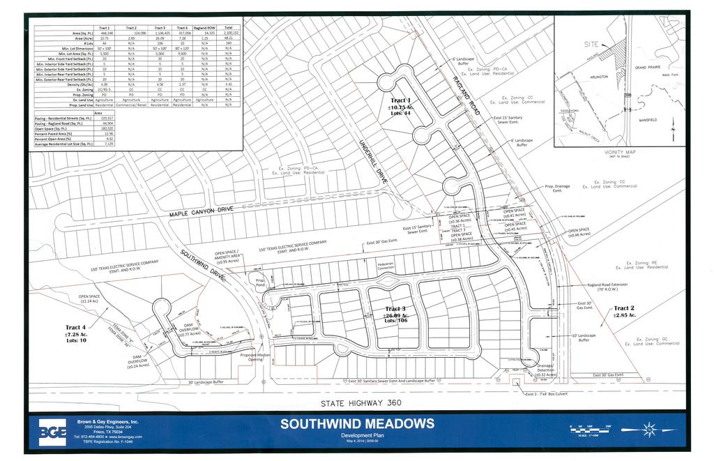
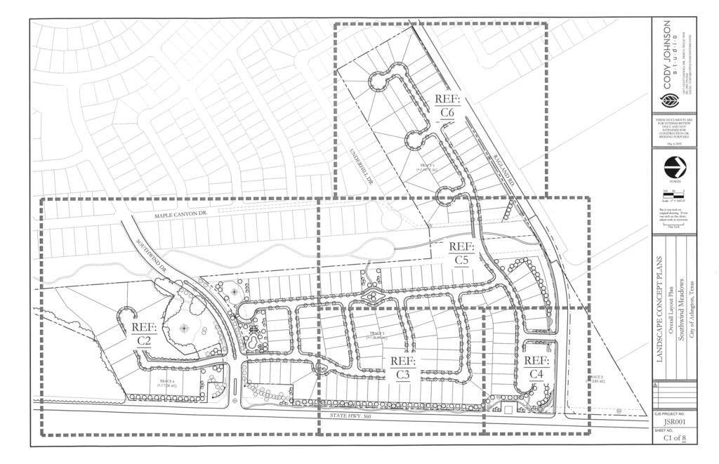
1 Staff Report Zoning Case PD15-1 (Southwind Meadows) Planning and Zoning Meeting Date: Document Being Considered: Ordinance RECOMMENDATION Following the public hearing, consider Planned Development PD15-1, with a Development Plan. PRIOR BOARD OR COUNCIL ACTION None ANALYSIS Request The applicant requests to change the zoning on approximately 48.2 acres addressed at 944, 1000, 1010, 1020, and 1030 Ragland Road, and generally located south of Ragland Road and west of South Watson Road. Current zoning: Requested zoning: Planned Development (PD) for Residential Single-Family 5 (RS-5), Office Commercial (OC), Neighborhood Commercial (NC), and Community Commercial (CC), with exclusions. Planned Development (PD) for Residential Single-Family 5 (RS-5) and Community Commercial (CC) uses, with a Development Plan The subject property, which has PD zoning with an expired development plan, allowed for the construction of single family residential and commercial uses. The proposed rezoning will limit the development to primarily single family residential construction, and remove the majority of the commercial zoning from the previously approved PD. Only the northeast portion of the property will allow commercial uses north of the proposed Ragland Road. Adjacent Land Uses The adjacent property to the west is developed with single family homes and is zoned PD. The property to the south is undeveloped, and is zoned Residential Estate (RE). The property to the north is developed as a gas well site and is zoned Community Commercial (CC), an Electric Utility Substation zoned RE, and vacant property zoned General Commercial (GC). The property to the east is within the city limits of Grand Prairie, zoned agricultural, and is largely undeveloped. Development Plan The development plan indicates 160 single family lots and one commercial lot. The residential lots are divided into two different areas of differing lot sizes. The proposed 150 lots on the north side of Southwind Drive and adjacent to Ragland Road are to be a minimum lot size of 5,000 square feet. The ten lots located south of Southwind Drive will be a minimum of 9,600 square feet in size. Open Space The applicant is proposing to include four amenity lots for use by the residents throughout the development. The largest amenity lot, adjacent to Southwind Drive, provides a pool, gazebo, and amenity center building to include restrooms. A pond and fountain are proposed west of the pool. The amenity lot located in the northeast corner of Tract 3, which is located in a drainage/detention area, will include increased landscaping including four-
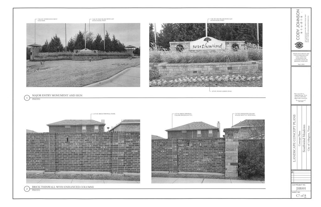
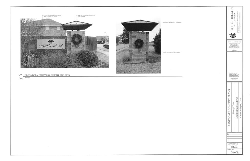
2 Page 2 of 3 inch caliper shade trees and a continuation of the sidewalk interior to the development connecting to the sidewalk along South Watson Road. Six-foot tall ornamental fencing will be used for the residential lots adjacent to the amenity lots. Trail System A midblock amenity lot on the western edge of the proposed site would provide a new sixfoot concrete trail and entrance to connect to the neighboring development s existing trail system. The trail system is also proposed to be extended to the north and connect to Ragland Road within the Oncor easement area by creating an amenity lot between Tract 1 and Tract 3. Internal Streetscape The development shall comply with the internal streetscape standards of the Unified Development Code as a five-foot wide sidewalk and street trees are proposed. A landscaped traffic bulb is proposed midblock to provide a traffic calming measure. The location of the traffic bulb is placed to line up with the entrance of the amenity lot connecting the trail system to the street. This area will be landscaped with trees and shrubs in addition to turf grass. External Streetscape A five-foot sidewalk will continue along South Watson Road and connect to the existing sidewalk along Ragland Road. The perimeter of the development will contain a six-foot tall brick wall, with enhanced columns spaced at 50 foot intervals and at entrances to the development. This wall will be constructed of brick unit by unit with mortar between. No compressed cement type wall is proposed. The perimeter fencing complies with the enhanced fencing requirements to prevent monotony by providing the stone columns at 50 foot intervals. Trees planted at the perimeter of the development along South Watson Road and Ragland Road are proposed to be a minimum of four caliper inches at the time of planting. The proposed landscaped beds at the perimeter of the development are curvilinear in nature, with taller evergreen shrubs on the backside of the beds, and with shrubs and ornamental grasses in front to provide additional aesthetic appeal to the street frontage and soften the appearance of the wall. There is no development plan submitted for the one proposed commercial lot on the north side of the proposed Ragland Road extension at this time. Any future development will need to comply with Non-Residential Design Standards of the UDC. Comprehensive Plan Analysis The 2015 Comprehensive Plan, 99 Square Miles, contains goals to provide residential neighborhoods with a variety of high quality housing options for Arlington s current residents. In addition to providing a pleasant residential neighborhood environment in the Southeast sector, the proposed development increases the supply of moderate-income housing and will offer a small number of larger lots with the ability to construct ten custom homes in Tract 4, south of Southwind Drive. While the area is established with existing residential and the proposed development is consistent the existing development, the area will benefit from the expansion of State Highway 360 and there is an opportunity to provide a broader mix of options.
3 Page 3 of 3 FINANCIAL IMPACT None ADDITIONAL INFORMATION Attached: i. Case Information ii. Itemized Allowable Uses iii. Location Map iv. Photos v. Development Plan (9 pages) Under separate cover: None Available in the City Secretary s office: None CITY COUNCIL DATE June 16, 2015 STAFF CONTACTS Gincy Thoppil, AICP Shon Brooks Development Planning Manager Senior Planner Community Development and Planning Community Development and Planning Gincy.Thoppil@arlingtontx.gov Shon.Brooks@arlingtontx.gov
4 Case Information Applicant: Property Owner: Sector Plan: Brown and Gay Engineers represented by Bo Trainor Southwind Development LLC represented by Brown and Gay Engineers Southeast Council District: 3 Allowable Uses: Development History: Residential Single-Family and Commercial The subject site is currently unplatted. No previous zoning cases have occurred in the general vicinity within the past five years. Transportation: The proposed development has two points of access. One point of access is from South Watson Road. The other is from Ragland Road. Thoroughfare Existing Proposed South Watson Road Ragland Road 450' - 4 Lane Divided Highway 70-3 Lane Major Collector, including left-turn center lane 450' - 6 Lane Divided Highway, plus 2 Lane southbound and northbound frontage roads 70-3 Lane Major Collector, including left-turn center lane Traffic Impact: Water & Sewer: Trip generation is determined from the average rates for Single-Family Detached Housing from the 8th Edition ITE Trip Generation Manual, based on 161 dwelling units. Change in zoning will increase the average daily trips by 1541, with an addition of 124 trips during the a.m. peak hour and 165 trips during p.m. peak hour. The additional trips will not significantly impact the adjacent roadway systems. The intersection of the subdivision entrance at the beginning of the Ragland Road intersection is not a typical configuration. Further details will be needed on the layout of this intersection. Water and sanitary sewer are available to the site through Southwind Drive, along South Watson Road north of Southwind Drive, and along Ragland Road. Zoning Case: PD15-1 i-1 Prepared: SHON BROOKS
5 Case Information Drainage: This site is located in the Walnut Creek Drainage Basin. This site has approximately 5 percent within the FEMA floodplain. There is an existing drainage channel that spans from Ragland Road south to Southwind Drive, where proposed lots are located. A drainage analysis will need to provide an engineered solution for the conveyance of storm water through that area to the culvert under Southwind Drive, and for the dam overflow runoff. No significant drainage impacts are expected to result if development complies with all relevant City ordinances. Fire: School District: Fire Station Number 16, located at 1503 Mansfield Webb Road, provides protection to this site. The estimated fire response time is within five minutes, which is in keeping with recommended standards. Mansfield Independent School District. The proposed zoning request is located in the Mansfield Independent School District (MISD). Notices Sent: Neighborhood Associations: ACTION North Arlington Alliance for Responsible Government Arlington Chamber of Commerce Arlington Neighborhood Council East Arlington Renewal East Arlington Review Far South Arlington Neighborhood Association Forest Hills Home Owners Association Northern Arlington Ambience West Citizen Action Network (WeCan) Deer Creek Neighborhood Watch Harris Crossing HOA Southwind HOA Property Owners: 86 Letters of Support: 0 Letter of Opposition: 0 Zoning Case: PD15-1 i-2 Prepared: SHON BROOKS
6 Itemized Allowable Uses Allowable Uses Planned Development (PD) for all Residential Single- Family 5 (RS-5) uses and Community Commercial (CC) uses, with a Development Plan Permitted (RS-5) - Dwelling, single-family detached on minimum 5,000 Square Feet, Non-Residential on minimum 15,000 square foot lots, Assisted living facility ( 6 residents), Community home for disabled persons, Foster family home, Foster group homes, Government administration and civic buildings helter, Religious assembly, Public or private school, Cemetery, Community garden, Public park or playground, Golf course, Utility lines, towers or metering station, garage-private, accessory swimming pool-private Permitted (CC) - Nursing home, Art gallery or museum, Government administration and civic buildings, Domestic violence shelter, Mortuary/crematory/funeral chapel, Philanthropic institution (other than listed), Religious assembly, Business school, Public or private school, University/college/seminary, Hospital, Medical or dental office or clinic, Cemetery, Community garden, Public park or playground, Crop production, Gasoline sales, Catering service, Restaurant, Restaurant/take-out and delivery only, Office/business or professional, Telemarketing call center, Day care center, Private club/lodge/fraternal, General personal services (other than listed), Massage therapy clinic, Recreation/ indoor (other than listed), Wedding chapel, Country club, Golf course, Major tourist attraction, General retail store (other than listed), Firearm sales, Pawn shop, Second-hand goods store, Swimming pool/spa and accessory sales and service, Medical or scientific research laboratory, Electric utility substation, Radio or TV station or studio, Utility lines, towers or metering station Specific Use Permit (SUP) (RS-5) - Assisted living facility ( 7 residents), Philanthropic institution (other than listed), Bed and breakfast inn, Country club, Marina, Airport or landing field, Gas well, Telecommunication Facilities Towers 75 ft., Stealth towers 100 ft., Telecommunication Facilities Towers >75 ft., Stealth towers >100 ft. Specific Use Permit (SUP) (CC) - Halfway House, Hospital/psychiatric, Hotel/limited service, Residence hotel, Bail bond service, Banquet hall, Billiard parlor, Bowling alley, Bingo hall, Gun range, Night club, Recreation general outdoor (other than listed), Marina, Specialty paraphernalia sales, Wrecker service, Gas well, Transit passenger terminal, Utility installation other than listed, Telecommunication Facilities Towers >75 ft., Stealth towers >100 ft., Self-storage facility Zoning Case: PD15-1 Prepared: SHON BROOKS ii-1
7 Itemized Allowable Uses Conditions (C) (RS-5) Telecommunication Facilities Building-mounted antennae and towers, Nursery garden shop or plant sales, Telecommunication Facilities Building-mounted antennae and towers Conditions (C) (CC) Kennel/commercial, Veterinary clinic, Motor vehicle rental, Financial services, Restaurant with drivethrough, Sidewalk café, Hotel/full service, Skating rink, Teen club, Theatre indoor, Building and landscaping materials and lumber sales, Nursery/garden shop or plant sales, Food processing, Custom and craft work, Telecommunication Facilities Building-mounted antennae and towers, Telecommunication Facilities Towers 75 ft., Stealth towers 100 ft. Zoning Case PD15-1 A-2 Prepared: SHON BROOKS

8 RIVER BLUFFS DR SUP COLD CREEK DR RAGLAND RD DENALI DR WATER OAK DR WILD RIVER DR Feet LOCKHART DR SHADOWFAX BASTROP DR DR BEEMAN DR SOUTHWIND DR This product is for informational purposes and may not have been prepared for or be suitable for legal, engineering, or surveying purposes. It does not represent an on-the-ground survey and represents 09535only the approximate relative location of property boundaries. S WATSON RD HWY 360 SVC RD NB LOCATION MAP PD15-1 Planned Development for RS-5 and CC uses 48.2 ACRES / ^_ Prepared: iii-1 NB


9 PD15-1 South of Ragland Road and west of South Watson Road View of the subject site. View west from South Watson Road. View of residential subdivision to West. View west. View of the adjacent electric substation. View north. View of one of three notification signs. west on Southwind Drive. View iv-1
10
11
12
13
14
15
16
17
18
Mycoskie McInnis Associates represented by Cliff Mycoskie. Rdw Rudy s Arlington and I-20/South Collins, Ltd represented by Robert Dorazil
 Case Information Applicant: Property Owner: Sector Plan: Mycoskie McInnis Associates represented by Cliff Mycoskie Rdw Rudy s Arlington and I-20/South Collins, Ltd represented by Robert Dorazil East Council
Mycoskie McInnis and Associates represented by Cliff Mycoskie. The proposed development has one point of access from South Bowen Road.
 Case Information Applicant: Property Owner: Sector Plan: Mycoskie McInnis and Associates represented by Cliff Mycoskie Gary Travis West Council District: 4 Allowable Uses: Development History: All uses
7007 South Cooper Street generally located north of West Harris Road and east of South Cooper Street
 Case Information pplicant: Property Owner: Dallas Cothrum with Masterplan Consultants Chesapeake Land Development Company, LLC creage: 6.533 Property Location: Sector Plan: 7007 South Cooper Street generally
On January 12, 2010, the City Council approved first reading of this case by a vote of
 Staff Report Zoning Case SUP09-20 (Arkansas Lane Drill Site) City Council Meeting Date: 1-26-10 Document Being Considered: Ordinance RECOMMENDATION Approve an ordinance changing the zoning classification
Zoning Case PD14-19 (Woody s Backyard) Planning and Zoning Meeting Date: Document Being Considered: Ordinance
 Planning and Zoning Meeting Date: Document Being Considered: Ordinance") Staff Report Zoning Case PD (Woody s Backyard) Planning and Zoning Meeting Date: 2415 Document Being Considered: Ordinance RECOMMENDATION Following the public hearing, consider Zoning Case PD, with a Development
Staff Report Zoning Case PD (Woody s Backyard) Planning and Zoning Meeting Date: 2415 Document Being Considered: Ordinance RECOMMENDATION Following the public hearing, consider Zoning Case PD, with a Development
The subject site is currently platted as W.D. Lacy Addition and commonly known as Block 29.
 Applicant/Owner: Sector Plan: QuikTrip represented by Jake Petras Southeast Council District: 3 Allowable Uses: Development History: All uses as itemized in attachment ii. The subject site is currently
Request Conditional Use Permit (Car Wash Facility) Staff Recommendation Approval. Staff Planner Jonathan Sanders
 Staff Recommendation Approval. Staff Planner Jonathan Sanders") Applicant Property Owner SunTrust Bank Public Hearing October 10, 2018 City Council Election District Princess Anne Agenda Item 2 Request Conditional Use Permit (Car Wash Facility) Staff Recommendation
Applicant Property Owner SunTrust Bank Public Hearing October 10, 2018 City Council Election District Princess Anne Agenda Item 2 Request Conditional Use Permit (Car Wash Facility) Staff Recommendation
Application Number: SD Project Name: Walton Farms Preliminary Subdivision (acting as Master Plan)
") STAFF REPORT Town of Clayton Planning Department 111 E. Second Street, Clayton, NC 27520 P.O. Box 879, Clayton, NC 27528 Phone: 919-553-5002 Fax: 919-553-1720 Planning Board May 22, 2017 Application Number:
STAFF REPORT Town of Clayton Planning Department 111 E. Second Street, Clayton, NC 27520 P.O. Box 879, Clayton, NC 27528 Phone: 919-553-5002 Fax: 919-553-1720 Planning Board May 22, 2017 Application Number:
Development Review Application Fees
 Development Review Application Fees Application Type Historic District Commission (Requires zoning sign- $10) Certificate of Approval Certification of Non-Conforming Use- Residential Use for the property
Planning Districts INTRODUCTION
 INTRODUCTION To facilitate detailed examination of development prospects for all areas of the community, Delano has been divided into 14 planning districts. The location of these planning districts is
PLANNED UNIT DEVELOPMENT Date: April 5, 2018
 PLANNED UNIT DEVELOPMENT Date: April 5, 2018 DEVELOPMENT NAME SUBDIVISION NAME LOCATION Robert Myers Robert Myers 2955 and 2989 Dauphin Street (Southeast corner of Dauphin Street and Sage Avenue) CITY
Statement of Intent Proposed Development Five Forks Athletics Scuffletown Rd, Greenville SC
 Statement of Intent Proposed Development Five Forks Athletics Scuffletown Rd, Greenville SC Tax Map #0548020103205 1 P a g e Table of Contents Statement of Intent...page 3-9 Exhibit A Utility Letters Exhibit
General Location Courtyard at LMH Final Development Plan and Final Plat
 R-1 LEYDEN RIDGE LOMA RIDGE LOBDELL R-3 MILLER PARKWAY LAUSSAC Subject Property R-3 LOCHENSHIRE LESMER R General Location Courtyard at LMH Final Development Plan and Final Plat ¹ 230 115 0 230 Feet Airport
2 Project Description
 Project Description 2 Project Description The proposed project would involve the demolition of the existing church and the construction of 40 twostory single family residences. The residential lots would
12 January 12, 2011 Public Hearing APPLICANT: TAILWIND DEVELOPMENT GROUP,LLC PROPERTY OWNER: CITY OF VIRGINIA BEACH
 12 January 12, 2011 Public Hearing APPLICANT: TAILWIND DEVELOPMENT GROUP,LLC PROPERTY OWNER: CITY OF VIRGINIA BEACH STAFF PLANNER: Faith Christie REQUEST: Conditional Change of Zoning (from PD-H1 Planned
Design Guidelines for Residential Subdivisions
 Design Guidelines for Residential Subdivisions Development Services 972-466-3225 cityofcarrollton.com This page intentionally left blank. Table of Contents Purpose... 1 Design Objectives... 1 Design Guidelines
Rezoning Petition Pre-Hearing Staff Analysis March 19, 2018
 Rezoning Petition 2017-171 Pre-Hearing Staff Analysis March 19, 2018 REQUEST Current Zoning: R-3 (single family residential) Proposed Zoning: MX-2 (INNOV) (mixed used, innovative) with five-year vested
FOR SALE 21 acres of Limited Industrial Land 6.4 acres of Commercial Land Baldwin Road West, Monrovia, Maryland 21770
 21 acres of Limited Industrial Land 6.4 acres of Commercial Land, I-70 Frontage and Visibility Established Industrial and Commercial Area PRESENTING LOCATION: Intersection of and Green Valley Road LEGAL:
KNOXVILLE/KNOX COUNTY METROPOLITAN PLANNING COMMISSION SUBDIVISION REPORT - CONCEPT/USE ON REVIEW
 KNOXVILLE/KNOX COUNTY METROPOLITAN PLANNING COMMISSION SUBDIVISION REPORT - CONCEPT/USE ON REVIEW FILE #: 10-SF-17-C 10-I-17-UR AGENDA ITEM #: 12 AGENDA DATE: 11/9/2017 POSTPONEMENT(S): 10/12/2017 SUBDIVISION:
KASPER. City of Georgetown, Texas PUD Planned Unit Development. December 30, 2015 Revised January 27, 2016
 KASPER City of Georgetown, Texas PUD Planned Unit Development December 30, 2015 Revised January 27, 2016 Applicant: Sentinel Land Company, LLC 4910 Campus Drive Newport Beach, CA Prepared by: SEC Planning
SECTION 21. MU-VS MIXED USE VIRGINIA SQUARE DISTRICTS
 SECTION 21. MU-VS MIXED USE VIRGINIA SQUARE DISTRICTS The purpose of the MU-VS Mixed Use Virginia Square classification is to encourage coordinated mixed-use development of medium-density residential and
Rezoning Petition Pre-Hearing Staff Analysis October 15, 2018
 Rezoning Petition 2017-137 Pre-Hearing Staff Analysis October 15, 2018 REQUEST Current Zoning: R-3 (single family residential) Proposed Zoning: B-2(CD) (general business, conditional) LOCATION Approximately
Request Alternative Compliance to the prescribed criteria of the Oceanfront Resort District Form- Based Code. Staff Recommendation Approval
 Applicant Property Owner Steven H. Murden Public Hearing June 14, 2017 City Council Election District Beach Agenda Item 8 Request Alternative Compliance to the prescribed criteria of the Oceanfront Resort
CHAPTER 21 NC-PUD NEIGHBORHOOD COMMERCIAL PUD DISTRICT
 CHAPTER 21 NC-PUD NEIGHBORHOOD COMMERCIAL PUD DISTRICT Section 21.1. Title and Purpose. The Neighborhood Commercial Planned Unit Development District, designated the, is intended for commercial uses of
EXHIBIT B PROJECT NARRATIVE POULSBO MEADOWS
 EXHIBIT B PROJECT NARRATIVE POULSBO MEADOWS Name of Project: Poulsbo Meadows; A Planned Residential Development (PRD)/Plat Applicants Name: PBH Group LLC/Byron Harris PO Box 1010 Silverdale, WA 98038 Description
Urban Planning and Land Use
 Urban Planning and Land Use 701 North 7 th Street, Room 423 Phone: (913) 573-5750 Kansas City, Kansas 66101 Fax: (913) 573-5796 Email: planninginfo@wycokck.org www.wycokck.org/planning To: From: City Planning
CONSENT CALENDAR CITY PLANNING COMMISSION AGENDA ITEM NO: A.1, A.2 STAFF: LARRY LARSEN
 Page 8 CONSENT CALENDAR CITY PLANNING COMMISSION AGENDA ITEM NO: A.1, A.2 STAFF: LARRY LARSEN FILE NO: CPC PUZ 14-00013 - QUASI-JUDICIAL FILE NO: CPC PUD 14-00014 QUASI-JUDICIAL PROJECT: APPLICANT: OWNER:
Rezoning Petition Pre-Hearing Staff Analysis April 16, 2018
 Rezoning Petition 2018-015 Pre-Hearing Staff Analysis April 16, 2018 REQUEST LOCATION Current Zoning: R-4 (single family residential) and UR-2(CD) (urban residential, conditional) Proposed Zoning: UR-2(CD)
Request Conditional Rezoning (R-15 Residential to Conditional A-24 Apartment) Staff Recommendation Approval. Staff Planner Jimmy McNamara
 Staff Recommendation Approval. Staff Planner Jimmy McNamara") Applicant Franklin Johnston Group Management & Development, LLC Property Owner Virginia Wesleyan College Public Hearing July 12, 2017 City Council Election District Bayside Agenda Item 3 Request Conditional
Applicant Franklin Johnston Group Management & Development, LLC Property Owner Virginia Wesleyan College Public Hearing July 12, 2017 City Council Election District Bayside Agenda Item 3 Request Conditional
4 January 11, 2012 Public Hearing APPLICANT:
 . 4 January 11, 2012 Public Hearing APPLICANT: MID-ATLANTIC AUTO PROPERTY OWNER: DZR, LLC STAFF PLANNER: Leslie Bonilla REQUEST: Conditional Use Permit (truck rental, automobile service, and automotive/bulk
2.11 GC - General Commercial
 2.11 GC - General Commercial Intent - GC: s are established to provide a location for higher volume and higher intensity commercial uses than the NR District. Activities in this District are often large
Sheet Index. Legal Description. General Notes: Vicinity Map Scale 1" = 600'
 LOCATED IN THE SOHWEST QUARTER OF SECTION, TOWNSHIP SOH, Case # Z 6 - Legal Description Tract G, H and J of the Villages at Riverdale Filing No., a part of the Southwest quarter of Section, Township South,
CONCEPT BRIEF. 101 West Abram Street Arlington, Texas
 CONCEPT BRIEF 101 West Abram Street Arlington, Texas 76010 817-459-6502 www.arlingtontx.gov/planning PD13-18 Case Number: Form must be filled out completely. Please type or legibly print all information.
13. PRELIMINARY PLAT NO MILLS FARM - Vicinity of the southeast corner of 159 th Street and Quivira Road
 13. corner of 159 th Street and Quivira Road 1. APPLICANT: HNTB Corporation is the applicant for this request. 2. REQUESTED ACTION: The applicant is requesting approval of a preliminary plat for a 383-lot
Electric (208/120 v 3 phase), Natural Gas, Water & Sewer
, Natural Gas, Water & Sewer") FOR LEASE CALL FOR PRICING 2 East Patrick Street, Frederick, Maryland 21701 Exceptional Frederick Historic Location Located at the corner South Market and East Patrick Streets in Downtown Frederick, this
FOR LEASE CALL FOR PRICING 2 East Patrick Street, Frederick, Maryland 21701 Exceptional Frederick Historic Location Located at the corner South Market and East Patrick Streets in Downtown Frederick, this
ZONING. 230 Attachment B
 230 Attachment B Village of Croton-on-Hudson Schedule of Uses Please note: All information contained in the zoning schedules is designed to supplement and summarize the information contained in the zoning
Rezoning Petition Final Staff Analysis June 18, 2018
 Rezoning Petition 2018-028 Final Staff Analysis June 18, 2018 REQUEST Current Zoning: MX-1 LLWPA (mixed use district, Lower Lake Wylie Protected Area), R-3 LLWPA (single family residential, Lower Lake
Zoning Interface: Districts and Forms for Sioux Falls Zoning Ordinance
 Zoning Interface: Districts and Forms for Sioux Falls Zoning Ordinance For more information about each form, click on the associated link. Single-Family Residential Districts RR Rural Residential RS Single-Family
Mill Conversion Overlay District Zoning Bylaw Amendment
 Mill Conversion Overlay District Zoning Bylaw Amendment To see if the Town will vote to amend the Zoning By-Law by adding a new Section 13, Mill Conversion Overlay District, and by amending Sections 2.1,
UNIVERSITY OF MICHIGAN:
 Chapter Eight UNIVERSITY OF MICHIGAN: North Campus I. Introduction The University of Michigan currently owns approximately 800 acres of land in the northeast section of Ann Arbor. North Campus refers to
M E M O R A N D U M. Consider a recommendation of a site plan for Sherwin Williams, a proposed approximately 4,500 square-foot paint store.
 M E M O R A N D U M Meeting Date: February 10, 2014 Item No. E- 8 To: From: Subject: Planning and Zoning Commission Cassie Harashe, Planner I Consider a recommendation of a Site Plan for Sherwin Williams,
Request Conditional Rezoning (R-15 Residential to Conditional B-2 Community Business) Staff Planner Kevin Kemp
 Staff Planner Kevin Kemp") Applicant Property Owner Three Five Ministries, Inc. Public Hearing May 11, 2016 City Council Election District Lynnhaven Agenda Item 4 Request Conditional Rezoning (R-15 Residential to Conditional B-2
Applicant Property Owner Three Five Ministries, Inc. Public Hearing May 11, 2016 City Council Election District Lynnhaven Agenda Item 4 Request Conditional Rezoning (R-15 Residential to Conditional B-2
STAFF REPORT SPECIAL USE DISTRICT REZONING
 STAFF REPORT SPECIAL USE DISTRICT REZONING ZONING DOCKET: K-751 PLANNING BOARD: March 13, 2017 PETITIONER: Abigaile Pittman, Agent for Owner OWNERS: Greenwood and Charles, Inc. PROPOSED ZONING AMENDMENT:
Rezoning Petition Pre-Hearing Staff Analysis September 17, 2018
 Rezoning Petition 2017-043 Pre-Hearing Staff Analysis September 17, 2018 REQUEST Current Zoning: R-3 (single family residential), R-17MF (multi-family residential), and CC (commercial center) Proposed
Ten Mile Creek Planning Area
 PLANNING AREA POLICIES TEN MILE CREEK Ten Mile Creek Planning Area Location and Context The Ten Mile Creek Planning Area ( Ten Mile Creek area ) is located south of the current Boise AOCI, generally south
Rezoning Petition Pre-Hearing Staff Analysis May 21, 2018
 Rezoning Petition 2018-028 Pre-Hearing Staff Analysis May 21, 2018 REQUEST Current Zoning: MX-1 LLWPA (mixed use district, Lower Lake Wylie Protected Area), R-3 LLWPA (single family residential, Lower
ROLL CALL Member Anthony, Member Avdoulos, Member Greco, Member Lynch, Member Maday, Chair Pehrson
 CALL TO ORDER The meeting was called to order at 7:00 PM. PLANNING COMMISSION ACTION SUMMARY CITY OF NOVI Regular Meeting July 11, 2018 7:00 PM Council Chambers Novi Civic Center 45175 W. Ten Mile (248)
Request Alternative Compliance (Commercial Parking Lot in Restricted Area) Staff Recommendation Approval. Staff Planner Ashby Moss
 Staff Recommendation Approval. Staff Planner Ashby Moss") Applicant Property Owners Pacific Avenue West, LLC Public Hearing April 11, 2018 City Council Election District Beach Agenda Item 2 Request Alternative Compliance (Commercial Parking Lot in Restricted
Applicant Property Owners Pacific Avenue West, LLC Public Hearing April 11, 2018 City Council Election District Beach Agenda Item 2 Request Alternative Compliance (Commercial Parking Lot in Restricted
ELECTION DISTRICT: PRINCESS ANNE
 D3 April 10, 2013 Public Hearing APPLICANT: HOLLOMON- BROWN FUNERAL HOME, INC. PROPERTY OWNER: HOLLOMON- BROWN FUNERAL HOME, INC. & TIDEWATER CEMETERY CORP. STAFF PLANNER: Karen Prochilo REQUEST: Conditional
4 September 14, 2011 Public Hearing APPLICANT:
 4 September 14, 2011 Public Hearing APPLICANT: MID-ATLANTIC AUTO PROPERTY OWNER: KHJ, LLC STAFF PLANNER: Leslie Bonilla REQUEST: Conditional Use Permit (motor vehicle rental, automotive service, and automotive/bulk
SYRINGA VALLEY SPECIFIC PLAN NARRATIVE
 SYRINGA VALLEY SPECIFIC PLAN NARRATIVE Introduction With this application, Pleasant Valley South LLC ( Pleasant Valley ) seeks the City of Boise s approval of a new Specific Plan Ordinance to be added
U.S. Highway 377 North Overlay District. 1. General Purpose and Description
 U.S. Highway 377 North Overlay District 1. General Purpose and Description The purpose of the U.S. Highway 377 North Overlay District is to implement the recommendations within the U.S. Highway 377 North
Mariposa Lakes. Planned Community. Project Overview. Stockton, CA
 Planned Community Stockton, CA Project Overview March 2007 Summary of Proposed Community is a master-planned community proposed for development on approximately 3,810 acres in southeast Stockton. In 2004,
14 October 10, 2012 Public Hearing APPLICANT: MPB, INC
 14 October 10, 2012 Public Hearing APPLICANT: MPB, INC PROPERTY OWNER: MUNDEN & ASSOCIATES, LP STAFF PLANNER: Karen Prochilo REQUEST: Conditional Change of Zoning (AG-1 & AG-2 to Conditional O-2) ADDRESS
OP Council Resolution June 16, Planning and Development Services
 OP-08-01 Council Resolution June 16, 2008 Planning and Development Services Kingsgate Landing Outline Plan Table of Contents 1.0 Introduction 1 1.1 Purpose of Plan 1 1.2 Plan Area Location 1 1.3 Ownership
Staff Report and Recommendation
 Community Planning and Development Planning Services 201 W. Colfax Ave., Dept. 205 Denver, CO 80202 p: 720.865.2915 f: 720.865.3052 www.denvergov.org/cpd TO: City Council Neighborhoods and Planning Committee
Gruene River Place PDD CONCEPT PLAN AND DEVELOPMENT STANDARDS
 Gruene River Place PDD CONCEPT PLAN AND DEVELOPMENT STANDARDS GRUENE RIVER PLACE PLANNED DEVELOPMENT DISTRICT As per Section 3.5, Chapter 144 of the City s Zoning Ordinance To: The Planning & Zoning Commission
Planning & Zoning Commission Meeting Date: June 04, 2012
 Meeting Date: June 04, 2012 Request Applicant Owner Zoning Preliminary/Final Plat of 24.114 acres of unplatted property into one lot with one reserve for landscape/open space. Extension of infrastructure
Major Development Plan
 Major Development Plan Application number: MDP2016.03 Nixon Road Subdivision Request: The applicant request that the City Council receive the planning board recommendation to approve with conditions a
THE MAY AVENUE OFFICE SUITES PLANNED UNIT DEVELOPMENT
 DESIGN STATEMENT OF THE PLANNED UNIT DEVELOPMENT OF: THE MAY AVENUE OFFICE SUITES THE VILLAGE, OKLAHOMA APPROVED: April 15, 2014 DEVELOPED BY: MARATHON CONSTRUCTION, LLC 10316 LAKESIDE DRIVE, THE VILLAGE,
12 November 10, 2010 Public Hearing APPLICANT: CHUNMA TAE KWON DO
 12 November 10, 2010 Public Hearing APPLICANT: CHUNMA TAE KWON DO PROPERTY OWNER: MOUNTAIN VENTURES VIRGINIA BEACH, LLC REQUEST: Conditional Use Permit (indoor recreational facility) STAFF PLANNER: Leslie
MONTGOMERY COUNTY PLANNING DEPARTMENT THE MARYLAND-NATIONAL CAPITAL PARK AND PLANNING COMMISSION
 MONTGOMERY COUNTY PLANNING DEPARTMENT THE MARYLAND-NATIONAL CAPITAL PARK AND PLANNING COMMISSION MCPB Item No. Date: 12-10-15 Leisure World Clubhouse II Addition Fitness Center, Limited Site Plan Amendment
Community Development Rezoning Report REZ14-006
 Community Development Rezoning Report REZ14-006 Planning Commission Board of Supervisors March 4, 2014 March 26, 2014 Applicant M & N Real Estate, LLC Tax Map Id 125-(A)- L20E,125-(A)- L20E1, portion of
FOR LEASE. Downtown Frederick Retail/Office Space for Lease. Property Details PRESENTING
 FOR LEASE $3,500/SF (Modified Gross Lease) 630 North Market Street, 1 st Floor, Frederick, Maryland 21701 PRESENTING Location: 630 North Market Street, 1 st Floor, Frederick, MD 21701 Downtown Frederick
CASE NUMBER: 16SN0701 APPLICANT: Hanky, LLC
 STAFF S ANALYSIS AND RECOMMENDATION Planning Commission (CPC) Public Hearing Date: MAY 17, 2016 CPC Time Remaining: 100 DAYS Applicant s Agent: DANIEL L. CASKIE (804-569-7060) Applicant s Contact: MICHAEL
(c) DH-3 - Dixie Highway High Intensity Mixed-Use District (i) DH-3 - Dixie Highway High Intensity Mixed-Use District Use Table.
 DH-3 - Dixie Highway High Intensity Mixed-Use District (i) DH-3 - Dixie Highway High Intensity Mixed-Use District Use Table.") EXHI BI TB EXHIBIT A (c) DH-3 - Dixie Highway High Intensity Mixed-Use District (i) DH-3 - Dixie Highway High Intensity Mixed-Use District Use Table. DH 3 Dixie Highway High Intensity Mixed Use District
EXHI BI TB EXHIBIT A (c) DH-3 - Dixie Highway High Intensity Mixed-Use District (i) DH-3 - Dixie Highway High Intensity Mixed-Use District Use Table. DH 3 Dixie Highway High Intensity Mixed Use District
STAFF REPORT DEVELOPMENT COMMISSION ZONING MEETING CITY OF COLUMBUS, OHIO JANUARY 10, 2019
 STAFF REPORT DEVELOPMENT COMMISSION ZONING MEETING CITY OF COLUMBUS, OHIO JANUARY 10, 2019 5. APPLICATION: Z18-063 Location: 4053 WEST BROAD STREET (43228), being 6.42± acres located at the southeast corner
Definitions. Average Daily Traffic Demand (ADT): The actual number or projected number of cars that pass a point in a 24-hour period.
: The actual number or projected number of cars that pass a point in a 24-hour period.") Definitions Access Management: A combination of physical techniques and transportation policies used to control the flow of traffic between roads and the surrounding lands. Alternative City Form Scenarios:
Definitions Access Management: A combination of physical techniques and transportation policies used to control the flow of traffic between roads and the surrounding lands. Alternative City Form Scenarios:
Rezoning Petition Pre-Hearing Staff Analysis May 21, 2018
 Rezoning Petition 2018-018 Pre-Hearing Staff Analysis May 21, 2018 REQUEST Current Zoning: R-5 (single family residential), R-5 HD-O (single family residential, historic district overlay) and B-2(CD) HD-O
Request Modification of Conditions of a Conditional Use Permit approved October 14, Staff Recommendation Approval. Staff Planner Stephen White
 Applicant Property Owner Public Hearing September 13, 2017 City Council Election District Lynnhaven Agenda Item 3 Request Modification of Conditions of a Conditional Use Permit approved October 14, 2003.
2.18 MU Mixed Use District.
 2.18. Intent - The is established to promote the development of an urban residential environment. The regulations are intended to encourage single family urban residential use and development while allowing
FOR LEASE. Ideal Downtown Frederick Location for Retail, Restaurant or Fitness PRESENTING
 FOR LEASE CALL FOR PRICING 125 East All Saints Street, Frederick, Maryland 21701 Ideal Downtown Frederick Location for Retail, Restaurant or Fitness Here is where the downtown action is today and will
Zoning Rewrite Implementation Worksession #3. Industrial Zones April 11, 2013
 Zoning Rewrite Implementation Worksession #3 Industrial Zones April 11, 2013 1 Industrial Zones Current I-1 942.19 acres 0.33% Current I-2 757.36 acres 0.27% Current I-3 (floating) 970.29 acres 0.34% Current
2 January 13, 2010 Public Hearing APPLICANT: AUTOBELL CAR WASH, INC
 REQUEST: Conditional Use Permit (car wash) 2 January 13, 2010 Public Hearing APPLICANT: AUTOBELL CAR WASH, INC PROPERTY OWNER: MESSER 1060 INDEPENDENCE BOULEVARD STAFF PLANNER: Carolyn A.K. Smith ADDRESS
2.0 AREA PLANS. Lakeside Business District. Lakeside Business District Land Use Categories:
 Lakeside Business District Lakeside Business District Land Use Categories: Campus Commercial Campus Commercial means a mixture of uses which includes corporate offices, office parks, hotels, commercial,
Chapter Purpose and Intent. 7.2 Applicability. 7.3 General Provisions RECREATIONAL OPEN SPACE
 Chapter 7. RECREATIONAL OPEN SPACE 7.1 Purpose and Intent The intent of this Chapter is to provide for centrally located, unencumbered land as neighborhood recreational open space and not to permit the
CITY PLANNING COMMISSION AGENDA. ITEM NO: 6.a 6.b STAFF: LONNA THELEN
 Page 156 CITY PLANNING COMMISSION AGENDA ITEM NO: 6.a 6.b STAFF: LONNA THELEN FILE NO(S): A. - CPC ZC 08-00069 QUASI-JUDICIAL B. - CPC CU 08-00070 QUASI-JUDICIAL PROJECT: APPLICANT: OWNER: PHIL LONG VALUCAR
STAFF SUMMARY FOR S17-02 SPECIAL USE PERMIT APPLICATION
 APPLICATION SUMMARY Case Number: S17-02 Request: STAFF SUMMARY FOR S17-02 SPECIAL USE PERMIT APPLICATION SUP application in order to develop a convenience food store. Applicant: Property Owner(s): Cindee
Section 9 NEIGHBORHOOD DESIGN
 Section 9 NEIGHBORHOOD DESIGN City of Lancaster Comprehensive Plan D u n k i n, S e f k o & A s s o c i a t e s, I n c. NEIGHBORHOOD DESIGN INTRODUCTION There are many ways in which a neighborhood can
AWH REPORT OF THE PLANNING AND DEVELOPMENT DEPARTMENT FOR APPLICATION FOR REZONING ORDINANCE TO PLANNED UNIT DEVELOPMENT
 AWH REPORT OF THE PLANNING AND DEVELOPMENT DEPARTMENT FOR APPLICATION FOR REZONING ORDINANCE TO PLANNED UNIT DEVELOPMENT MAY 8, 2014 The Planning and Development Department hereby forwards to the Planning
Drexel, Barrell & Co.
 Drexel, Barrell & Co. December 21, 2018 Engineers/Surveyors Boulder Colorado Springs Greeley 3 South 7 th Street Colorado Springs, Colorado 80905-1501 719 260-0887 719 260-8352 Fax El Paso County Planning
Mitchell Ranch South MPUD Application for Master Planned Unit Development Approval Project Narrative. Introduction
 Mitchell Ranch South MPUD Application for Master Planned Unit Development Approval Project Narrative Introduction Mitchell Ranch South is a proposed single family (detached) residential development on
ARLINGTON COUNTY, VIRGINIA
 ARLINGTON COUNTY, VIRGINIA County Board Agenda Item Meeting of January 27, 2007 DATE: January 12, 2007 SUBJECT: U-3101-04-2 Use Permit Review for drive-through facilities; premises known as 5222 Lee Highway
Request Conditional Use Permit (Bulk Storage Yard) Staff Planner Kevin Kemp
 Staff Planner Kevin Kemp") Applicant & Property Owner Public Hearing June 8, 2016 City Council Election District Beach Agenda Item 5 Request Conditional Use Permit (Bulk Storage Yard) Staff Planner Kevin Kemp Location 657 Phoenix
Applicant & Property Owner Public Hearing June 8, 2016 City Council Election District Beach Agenda Item 5 Request Conditional Use Permit (Bulk Storage Yard) Staff Planner Kevin Kemp Location 657 Phoenix
PLANNED UNIT DEVELOPMENT PUD For The Proposed Antietam Subdivision Escambia County, Florida. Introduction
 PLANNED UNIT DEVELOPMENT PUD For The Proposed Antietam Subdivision Escambia County, Florida Introduction The project is located in Escambia County approximately 0.75 + miles north of the US Highway 90,
Approved: CITY OF ARDEN HILLS, MINNESOTA PLANNING COMMISSION WEDNESDAY, AUGUST 5, :30 P.M. - ARDEN HILLS CITY HALL
 Approved: CITY OF ARDEN HILLS, MINNESOTA PLANNING COMMISSION WEDNESDAY, AUGUST 5, 2015 6:30 P.M. - ARDEN HILLS CITY HALL PLANNING CASES A. Planning Case 15-016; Final Planned Unit Development Arden Plaza;
Major Subdivision Sketch Plan Checklist
 This checklist provides specific requirements that are apart of the Sketch process. The entire process is described by the Huntersville Subdivision Review Process which details all the submittal and resubmittal
Elm Fork Land Use. Trinity River Corridor Project Committee May 13, 2013
 Elm Fork Land Use Trinity River Corridor Project Committee May 13, 2013 Purpose Discuss Trinity River planned Land Use and Appropriate Compatible Uses, particularly with respect to the Elm Fork Area 2
RESIDENTIAL PLANNED UNIT DEVELOPMENT / SUBDIVISION AND REZONING CONCEPT AND DEVELOPMENT STAGE PLAN SUBMITTAL NARRATIVE
 RESIDENTIAL PLANNED UNIT DEVELOPMENT / SUBDIVISION AND REZONING CONCEPT AND DEVELOPMENT STAGE PLAN SUBMITTAL NARRATIVE DEVELOPMENT TEAM DONEGAL SOUTH Maple Grove, Minnesota March 27, 2017 Applicant/Developer/Builder:
The petition proposes to rezone the site to allow all uses permitted in the B-1 (neighborhood business) district.
 district.") Rezoning Petition 2018-040 Pre-Hearing Staff Analysis June 18, 2018 REQUEST Current Zoning: R-17MF (multi-family residential) Proposed Zoning: B-1 (neighborhood business) LOCATION Approximately 0.38 acres
Rezoning Petition 2018-040 Pre-Hearing Staff Analysis June 18, 2018 REQUEST Current Zoning: R-17MF (multi-family residential) Proposed Zoning: B-1 (neighborhood business) LOCATION Approximately 0.38 acres
5.1.1 The streetscape along US Highway 64 (Brevard Road); and, The built environment within new residential developments; and,
; and, The built environment within new residential developments; and,") Article 5. Landscaping 5.1 Purpose The Town of Laurel Park s landscape standards are designed to create a beautiful, aesthetically pleasing built environment that will complement and enhance community
Article 5. Landscaping 5.1 Purpose The Town of Laurel Park s landscape standards are designed to create a beautiful, aesthetically pleasing built environment that will complement and enhance community
Urban Planning and Land Use
 Urban Planning and Land Use 701 North 7 th Street, Room 423 Phone: (913) 573-5750 Kansas City, Kansas 66101 Fax: (913) 573-5796 Email: planninginfo@wycokck.org www.wycokck.org/planning To: From: City Planning
MOBILE CITY PLANNING COMMISSION LETTER OF DECISION. October 22, 2010
 MOBILE CITY PLANNING COMMISSION LETTER OF DECISION Archbishop of Mobile 400 Government St. Mobile, AL 36602 Re: Case #SUB2010-00075 (Subdivision) 3650 Springhill Avenue (Northwest corner of Springhill
USA Addition of South & East Side Residential Parcels. USA Deletion of a Town of Christiana Parcel. Conversion from USA to Limited Service Area
 Village of Rockdale Village of Rockdale 148 Water Street Cambridge, WI 53523 Phone 608.423.1497 Fax 608.423.9694 Urban Service Area (USA) Amendment USA Addition of South & East Side Residential Parcels
Town Center. Block 5 Existing multifamily residential units are expected to remain.
 Area Guidelines Germantown s districts should be developed as distinct communities with unique features that are supported through the guidelines. The guidelines not only help distinguish these districts
Description of Preferred Alternative
 Chapter 2 Description of Preferred Alternative 2.1 Introduction This chapter of the programmatic Sammamish Town Center Sub-area Plan Final EIS provides a more detailed description of the Preferred Alternative
8 February 9, 2011 Public Hearing APPLICANT: 7-ELEVEN, INC.
 . 8 February 9, 2011 Public Hearing APPLICANT: REQUEST: Conditional Use Permit for an automobile service station with a convenience store ADDRESS / DESCRIPTION: 2448 Nimmo Parkway PROPERTY OWNER: COURTHOUSE
CHAPTER 20: INSTITUTIONAL USE DEVELOPMENT STANDARDS
 CHAPTER 20: INSTITUTIONAL USE DEVELOPMENT STANDARDS ARTICLE 1: GENERAL INSTITUTIONAL USE STANDARDS 320-01. Application The provisions of this Chapter shall apply to the following uses in any zone: (e)
RESOLUTION NO R
 e e RESOLUTION NO R04 0054 BE IT RESOLVED by the Mayor and City Council ofthe City ofpapillion that The Papillion Comprehensive Plan is hereby amended to incorporate the Option A Future Land Use Map Transportation
8 October 14, 2015 Public Hearing
 8 October 14, 2015 Public Hearing APPLICANT & PROPERTY OWNER: PRICE S HOLDINGS, LLC STAFF PLANNER: Karen Lasley REQUEST: A. Conditional Use Permit (Automobile Repair Garage) B. Change in Nonconforming