Adelaide Street / Canadian Pacific Railway (CPR) Grade Separation. Public Information Centre #1
|
|
|
- Barrie Sutton
- 6 years ago
- Views:
Transcription


1 1 Adelaide Street / Canadian Pacific Railway (CPR)
 #1 is to: Introduce the study Provide the study background")

2 Why Are We Here? 2 The purpose of Public Information Centre (PIC) #1 is to: Introduce the study Provide the study background and context Identify the problems and opportunities Present alternative planning solutions Illustrate the design concepts for a possible overpass or underpass Illustrate ideas for high quality urban design Obtain public feedback Identify the next steps in the study Please ask questions and make your opinions known!

, resulting in frequent blockage of Adelaide Street.")

3 What Is This Study About? 3 Adelaide Street is part of the neighbourhood fabric and area residents frequently walk and cycle to parks, schools, businesses and shopping areas. The street also supports broader travel across the City and will play a more important role with the proposed rapid transit on Richmond Street. This is CPR s mainline supporting regional train movements, and the CPR yard adjacent to Adelaide Street which utilizes the tracks for shunting trains (pushing or pulling a train or part of a train from the main line to a siding, or from one track to another), resulting in frequent blockage of Adelaide Street. The City has initiated a Class Environmental Assessment (EA) study to look at options, considering: The needs of all corridor users: vehicles, pedestrians, cyclists, CPR Surrounding communities: heritage conservation districts, heritage properties, McMahen Park, community mobility and connectivity Traffic operations and the potential need for turning lanes at select locations Changes in access to local roads Continued revitalization of the community through unique urban design
4 What Is The Process & Study Schedule? 4 The Municipal Class EA process enables the planning and implementation of municipal infrastructure projects taking into account the environmental setting, agency and local community interests and unique project requirements. Phase 1: Problem and Opportunity Phase 2: Alternative Planning Solutions Phase 3: Alternative Design Concepts Identify and describe Problems and Opportunities Identify planning solutions Document existing conditions Alternative Approaches / Solutions Consult with public and agencies Develop design concept alternatives Detailed inventories of social, cultural, economic environments Evaluate design alternatives and select a Preliminary Preferred Design Consult with public and agencies Notice of Commencement February 2016 PIC #1 Problems and Opportunities Alternative Approaches (Planning Solutions) Concepts illustrating overpass and underpass design concepts and urban design opportunities PIC #2 Fall 2016 Design Concepts and Evaluation Preliminary Preferred Design Urban Design Concept for the Preliminary Preferred Design Phase 4: Environmental Study Report Complete the Environmental Study Report (ESR) Place ESR on Public Record Notice of Completion Notice of Study Completion Spring 2017 Phase 5: Implementation (Long-Term) Proceed to detail design of the project Property acquisition and utility relocation Initiate construction

5 The Study Area 5


6 Study Background / Context 6 Crossing is confirmed as the City s highest priority new rail-road grade separation candidate site (Civic Works Committee October, 2013). Would provide a continuous north-south route through central London that is not interrupted by any other level rail crossings, increasing the efficiency of the road network for City commuters. Would provide an additional crossing in central London for extended delay events due to rail operational failures or collisions. The closest grade-separated crossing of the CPR to the west is Talbot Street, 1.8 km away. High priority for emergency services because it would provide an uninterrupted north-south corridor. The Smart Moves 2030 Transportation Master Plan identifies a need for traffic capacity optimization and transit priority on this corridor. Recognizing that the rail blockage backs-up southbound traffic well past Oxford Street and northbound traffic past King Street. Traffic delays create cut-through traffic onto local streets in the area as drivers attempt to find alternate routes. In 2005, the Rail Exposure Index (daily road traffic volumes x rail train volumes) identified the warrant for a grade separation. Since then, Adelaide Street traffic volumes have increased by more than 20%. The City s Development Charge Background Study (2014) identifies the Adelaide Street / CPR grade separation in its 2031 planning horizon, although timing is subject to annual review of capital budget priorities.


7 Study Background / Context 7 London ON Bikes Draft Plan now complete and available for review at: Colborne Street is the main northsouth signed bike route in the Adelaide Street area Segments of Colborne Street are also proposed for signed bike route with sharrow and bike lanes Central Avenue is an existing signed bike route Queens Avenue has existing bike lanes Pall Mall is proposed for a signed bike route Insert excerpt from cycling map


8 What is Happening on Adelaide Street? 8 Adelaide Street carries an average of 25,500 vehicles per day. Train crossings occur up to 43 times throughout the day which leads to road blockages up to 126 minutes per day (2 out of 24 hours). Traffic operations at key intersections - Oxford Street and Queens Avenue, have the highest incidence of collisions in the study area.
9 Problems and Opportunities 9 Problems Opportunities Frequent train crossings result in road being blocked for up to 43 times/day for a total of about 2 hours affecting vehicles, transit, cyclists and pedestrians. Blockages result in traffic delays and causes cut-through traffic onto local streets. Future travel demand associated with growth and with implementation of rapid transit on Richmond Street is expected to shift more vehicular traffic onto Adelaide Street. Excessive delays will increase idling time and emissions loadings. Relatively high incidence of collisions at Oxford Street and Queens Avenue. Separate rail traffic from vehicles, cyclists and pedestrians on Adelaide Street, improving access and circulation. Provide improved rail safety. Develop an innovative design that prioritizes pedestrians and improves the urban environment, while avoiding some of the common drawbacks to over/underpasses. Preserve and enhance the heritage character of the neighbourhood and McMahen Park. Create additional public space that complements the area surrounding the new bridge and creates a strong connection from one side to the other for pedestrians and cyclists. Uninterrupted road corridor needed for emergency planning and response. Create opportunities for future redevelopment along the corridor, in keeping with The London Plan, that integrates with the new street grade. Improve the surrounding streetscape and intersections to create a safe, pedestrianfriendly and welcoming public realm.
10 What Approaches Are Being Considered? 10 Possible Planning Solutions Description Key Considerations Does it Address the Problems and Opportunities Do Nothing No capital improvements. Continued operations and maintenance to the road. - Does not address the problems and opportunities. - Not osistet with City s log-term transportation network planning. Intersection Improvements Improve traffic operations by implementing dedicated turning lanes, new traffic signals, improve signal timing. - Improves traffic operations at the key intersections which will contribute to improving / optimizing traffic movement. - Results in some property impacts at intersections. - Does not address the primary problem of frequent blockage of vehicle, transit, pedestrian, cyclist traffic at the CPR crossing. Transportation Demand Management (TDM) Reduce overall demands by shifting to outside the critical periods, and to alternative modes of transportation (transit, walking, cycling). - Transit is a major strategic planning and policy focus within the City. Significant progress is being made to implementing an innovative transit plan. - TDM policies i City s Trasportatio Master Pla ad are eig ipleeted o a city-wide scale. Already being implemented through other City programs Traffic Capacity Improvements Widen Adelaide Street from 4 to 6 lanes; providing an additional lane in each direction. - Does not address the primary problem of frequent blockage at the rail crossing. - Results in substantial property impacts throughout corridor, including potential impact to heritage resources. - Provides opportunity for urban design elements to offset some of the impacts. Change in Rail Operations CPR modifies current and long term operations. Any possible planned changes will be carefully considered by the City. - Requesting changes to CPR operations is outside of the City s jurisditio opletely depedet o CPR s usiess plan. - CPR current operations and long term plans will be explored in consultation with CPR to ensure that all planning solutions recognize current and future CPR operations. - Even if operations change, the rail crossing still poses a blockage and a safety concern for through train movements. Not likely to fully address problems and opportunities but will be a consideration in any solution Partial Provide a partial grade separation with an overpass (road over rail) or underpass (road under rail) of some lanes (such as transit lanes.) Provide grade separation with an overpass (road over rail) or underpass (road under rail) - Adelaide Street is not an identified rapid transit corridor - A partial separation of mixed use traffic poses significant safety concerns - Retention of at-grade sidewalk crossings losses opportunity to improve pedestrian safety. - Directly addresses the primary problem. - Results in property impacts, including potential impact to heritage resources. - Provides opportunity for urban design elements to be developed which may enhance the corridor and continue the revitalization efforts of the community.
11 What Is A? 11 A grade separation is a means of physically separating different directions of traffic and / or modes of transportation. For the Adelaide Street / CPR crossing, a grade separation will be achieved through either: Overpass having the road go over the rail Underpass - having the road go under the rail A grade separation on Adelaide Street will provide for continuous and safe operation of CP Rail, and movement of vehicles, transit, pedestrians and cyclists on Adelaide Street. What else is typically involved in a grade separation? Realignment of underground services and utilities (sewers, watermains, hydro) Traffic detours, temporary impacts to traffic flow during construction Temporary or permanent interruption of local road connections Property requirements


12 What Does an Overpass Look Like? 12 Typical characteristics: Road is raised above rail tracks by about 9 metres (30 feet) No impact on rail corridor Road detour required to maintain vehicle and pedestrian traffic Relocation of utilities within a new utility corridor adjacent to the overpass Length of grade separation is typically longer than underpass Increases visibility of grade separation Increases noise levels, if not mitigated View from overpass to adjacent residences View adjacent residences to overpass (appears as grassed hillside)
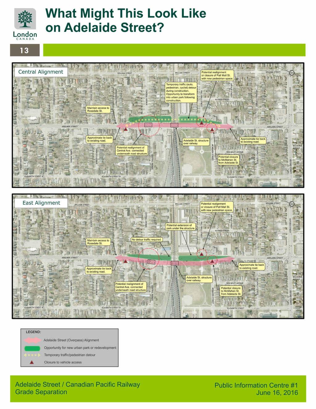
13
 Need to construct new")


14 What Does an Underpass Look Like? 14 Typical characteristics: Road is depressed below rail tracks by about 7 metres (23 feet) Need to construct new drainage outlet which may include pump station (Low Impact Development measures will be considered) Impacts to rail operations may require rail diversion or other measures to maintain rail traffic Road detour required to maintain vehicle and pedestrian traffic Relocation of utilities within a new utility corridor adjacent to the overpass Reduced length of grade separation limits compared to overpass Weber Street W., Kitchener Reduction in roadway noise levels due to lowering of road Improved redevelopment opportunities Weber Street W., Kitchener Weber Street W., Kitchener
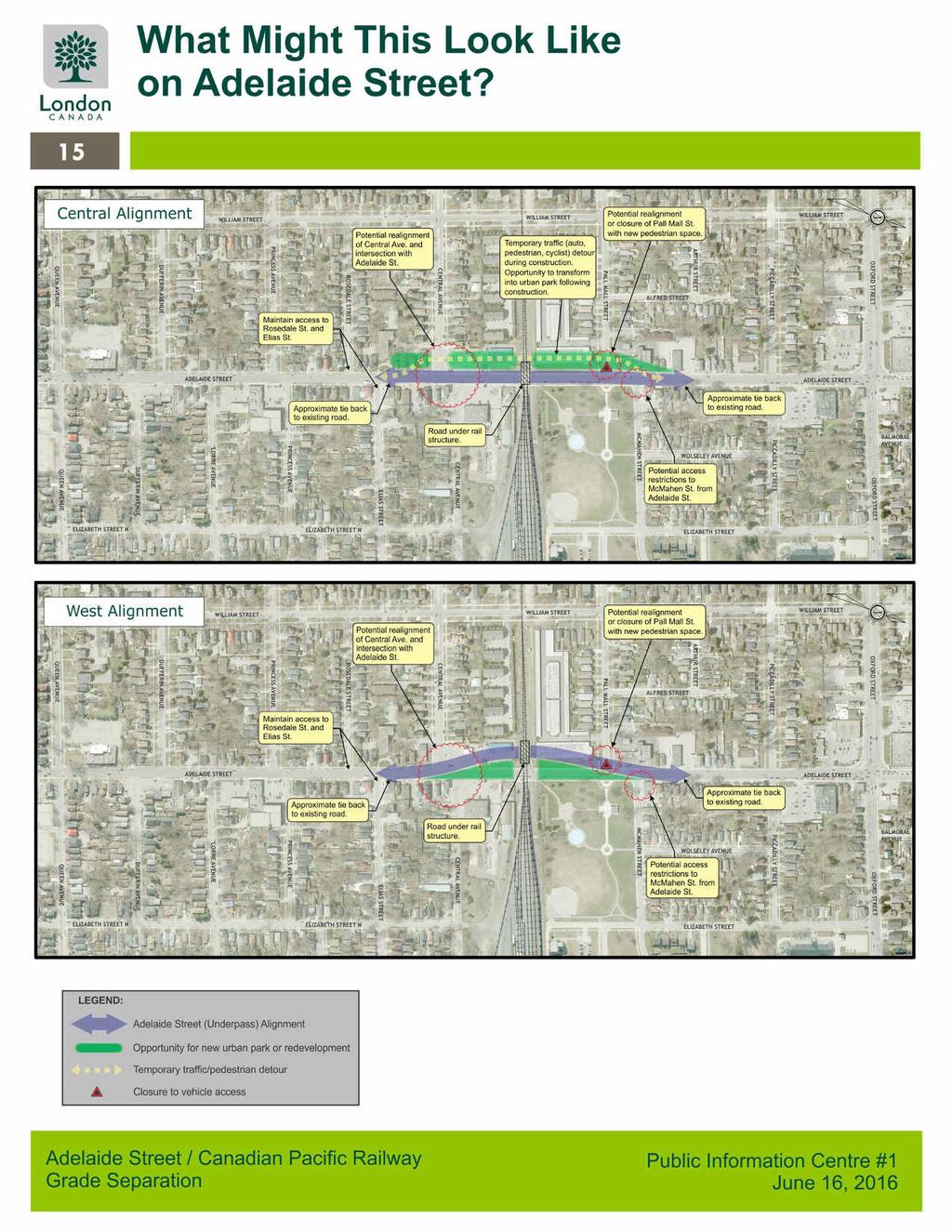
15


16 But What About The Community? 16 Community concerns we have heard to date: Physical barrier within community Reduced pedestrian and cyclist mobility and neighbourhood permeability Appearance of imposing walls and dark tunnels Creates hidden areas which leads to safety concerns Results in property impacts to the surrounding community May undermine significant efforts to revitalize the community Loss of park space Reduced access to local businesses Road blockage is not a significant issue City should encourage shift to transit, cycling and walking Neighbourhood will experience impacts in order to accommodate suburban traffic
17 But What About The Community? 17 There are many innovative ways to address some of the common concerns associated with grade separations Through urban design and landscaping, particular attention is paid to the relationship between the grade separation and the surrounding community, adjacent parks, pedestrian access and safety. Many projects around the world, and in Ontario, have created great spaces around newly developed structures, some examples are shown on the next several displays. PLACE A STICKER ON YOUR FAVOURITE DESIGNS IN THE FOLLOWING DISPLAYS!
18 Urban Design Opportunities Active Edges 18 Street-level redevelopment - The area surrounding a new underpass is ideal for new development that faces the new sidewalk. This approach creates a lively, public space at the underpass and eliminates the perception of grade change. Linear Urban Parks - New park space connects the upper and lower levels of underpasses with terraces, patios and green space. Gently sloping landform can open up the space to views and access. Park development beneath overpasses brings activity to the space and maintains the connection at street level. Activity Nodes Overlooks, setbacks with small plazas, and active features could enliven the space and open up the adjacent slopes.

19 Urban Design - Active Edges 19 PLACE A STICKER ON YOUR FAVOURITE DESIGNS!

20 Urban Design - Active Edges 20 PLACE A STICKER ON YOUR FAVOURITE DESIGNS!
21 Urban Design Opportunities Pedestrians First 21 Pedestrian Promenade Wide, multi-use pathway raised above traffic creates a level concourse beneath the underpass for pedestrians and bicyclists. Pedestrian walkways separated from traffic provide a safe space for pedestrians and cyclists to use the overpass and enjoy expansive views. Multiple Access Points Upper and lower levels are connected by ramps, steps and gently sloping open spaces in multiple locations. Pedestrian Underpass A dedicated pedestrian passage can connect the two sides of the rail bridge or overpass close to the original grade level, increasing access and connectivity. Pedestrian Bridges Pedestrian bridges re-establish the connection from one side of the street to the other, reducing the impact of the underpass on movement and accessibility of spaces.

22 Urban Design - Pedestrians First 22 PLACE A STICKER ON YOUR FAVOURITE DESIGNS!
23 Urban Design Opportunities Streetscape 23 Streetscape Design The public realm within and approaching the underpass is vital to success of the project. Streetscape design creates a welcoming and vibrant public space that enhances neighborhoods and stimulates commercial activity. Underpass and overpass connections are ideal to integrate a variety of public art, from sculpted landforms, patterned walls, and sculptural elements. Light Sculpture Another opportunity for public art is the creative use of lighting to illuminate the space and create a welcoming and dynamic atmosphere.

24 Urban Design - Streetscape 24 PLACE A STICKER ON YOUR FAVOURITE DESIGNS!

25 Urban Design Context Analysis 25

26 Urban Design Typical Profiles 26


 and utilities Geometric design")
27 Developing Design Concepts 27 Design Concepts will be developed for the overpass and underpass options. A number of key constraints and design elements are considered: Minimizing impacts to adjacent properties including significant heritage features Compatibility with adjacent community including Heritage Conservation Districts Opportunities for high quality urban design to minimize visual impacts and integrate the grade separation with the neighbourhood Minimizing impacts to McMahen Park Provision for pedestrians and cyclists Relocation of major services (water / wastewater) and utilities Geometric design requirements CPR operations
28 How Do We Decide on the Design? 28 A broad range of criteria is needed to assess the potential impacts of the design alternative and to address both form and function needs. Criteria fall under five general categories: Technical/ Operational (Road and CPR) Urban Design Social / Community Financial Cultural Heritage Considerations that reflect the five categories are provided on the next displays. Dot stickers can be used to indicate which considerations you feel are a high priority. CPR will have direct involvement in developing and evaluating design concepts. CPR input and agreement is critical to developing the design.
29 What is Most Important to You? 29 Transportation, Technical, and Cost Considerations Movement of Good and People Do the proposed improvements address the transportation needs and provide better level-ofservice for vehicles, cyclists and pedestrians? How important is this to you? Please rate each criterion. You may place more than one dot in the same criterion. Socio-Economic, Heritage, and Design Considerations Property Displacement or disruption to adjacent properties. How important is this to you? Please rate each criterion. You may place more than one dot in the same criterion. Road Right-of-Way Is the width of the corridor within the suggested range identified in the Official Plan? Community Character The effect on the overall character and local community. Local Street Connectivity The plan should minimize the impacts to local street connectivity for vehicles. Urban Design The urban design is a critical part of the project and should be a high priority investment by the City. Transit Transit is more efficient because delays at CPR are eliminated. Business Short or long-term impacts to local businesses. Capital and Operating Costs The cost to build, operate and maintain the structure. Redevelopment Potential The design offers potential for adjacent areas to be redeveloped and revitalize the corridor. Urban Design Costs Significant budget should be allocated to providing a high quality urban design. Noise and Air Quality Noise and air quality impacts are manageable and can be addressed. Detours Location of local detour. Must discourage and manage traffic infiltration into local neighbourhood during construction. Pedestrians and Cyclists The design provides safe and attractive opportunities for pedestrians and cyclists. Construction Duration of construction McMahen Park The design should avoid / minimize impacts to McMahen Park as much as possible. Emergency Services Public safety, Adelaide emergency Street planning and / Canadian response Pacific Railway should be considered highest priority Heritage Displacement of designated Heritage properties.
 Please complete our online")
30 Next Steps Stay Involved! 30 Following this PIC the Project Team will: Review all public and agency comments received Based on this input, confirm the preferred approach (planning alternative) Please complete our online comment sheet or send comments to one of the Project Team contacts: Develop and evaluate concepts Conduct meetings/workshops with interested stakeholders Conduct PIC 2 to present and request input on the design concepts (Fall 2016) Based on input received, confirm the preferred design Ardian Spahiu, P.Eng. City of London Project Manager City of London 300 Dufferin Avenue London, ON N6A 4L9 Tel: ext aspahiu@london.ca Jay Goldberg, P.Eng. Consultant Project Coordinator WSP MMM 2655 North Sheridan Way Mississauga, ON L5K 2P8 Tel: ext goldbergj@mmm.ca Prepare the Environmental Study Report and make available for a 30-day public review How to get involved: For the online comment sheet and PIC materials please visit: Request that your name be added to the study mailing list Provide your feedback by contacting the study team directly using the contact information to the right Participate in the next open house in fall 2016 Your comments are welcome at any time throughout the project. The online comment sheet will be available until August 31, 2016 to allow us to incorporate critical information into the next stage of the study. Thank you! Your involvement is essential to the success of this study We welcome your feedback
Adelaide Street / Canadian Pacific Railway (CPR) Grade Separation Class Environmental Assessment. Public Information Centre 3
 Grade Separation Class Environmental Assessment. Public Information Centre 3") 1 Adelaide Street / Canadian Pacific Railway (CPR) Grade Separation Study Process and Purpose of PIC 3 2 Study Commencement February 2016 Phase 1: Problem and Opportunity Identify problems and opportunities
1 Adelaide Street / Canadian Pacific Railway (CPR) Grade Separation Study Process and Purpose of PIC 3 2 Study Commencement February 2016 Phase 1: Problem and Opportunity Identify problems and opportunities
CHAIR AND MEMBERS CIVIC WORKS COMMITTEE MEETING ON AUGUST 13, 2018
 TO: FROM: SUBJECT: CHAIR AND MEMBERS CIVIC WORKS COMMITTEE MEETING ON AUGUST 13, 2018 KELLY SCHERR, P.ENG., MBA, FEC MANAGING DIRECTOR, ENVIRONMENTAL & ENGINEERING SERVICES AND CITY ENGINEER ADELAIDE STREET
City of London Adelaide Street North - Canadian Pacific Railway Grade Separation Class Environmental Assessment Study Report
 Executive Summary ES1 Introduction The City of London has completed a Class Environmental Assessment (Class EA) study for the Adelaide Street North - Canadian Pacific Railway Grade Separation. While the
St. Clair Avenue West Area Transportation Master Plan
 1 (Between Keele Street and Old Weston Road) Public Information Centre 1 December 2, 2015 2 Welcome Welcome to the first Public Information Centre for the St. Clair Avenue West Area. The panels will present
WELCOME TO OPEN HOUSE TWO November 28, 2018
 Langstaff Road Weston Road to Highway 7 Class Environmental Assessment Study WELCOME TO OPEN HOUSE TWO November 28, 2018 Please sign in and join our mailing list Study Overview York Region is conducting
Commissioners Road West Realignment Environmental Assessment
 City of London Commissioners Road West Realignment Environmental Assessment Public Information Centre No. 1 March 30, 2017 Welcome to the Public Information Centre This first Public Information Centre
Mavis Road Class Environmental Assessment
 Mavis Road Class Environmental Assessment Public Information Centre #2 Wednesday November 9, 2016 6:00 to 8:00 p.m. Please sign in and complete a comment sheet Review the displays on your own or join in
Shift Rapid Transit Public Participation Meeting May 3, 2017
 Shift Rapid Transit Public Participation Meeting May 3, 2017 Shift Rapid Transit Initiative Largest infrastructure project in the city s history. Rapid Transit initiative will transform London s public
Bostwick Road. Municipal Class Environmental Assessment. October 13, City of London. Bostwick Road Municipal Class Environmental Assessment
 Bostwick Road Municipal Class Environmental Assessment October 13, 2016 Welcome! Welcome to the first Public Information Centre for the Bostwick Road Municipal Class Environmental Assessment. Representatives
FANSHAWE PARK ROAD/RICHMOND STREET INTERSECTION IMPROVEMENTS. PUBLIC INFORMATION CENTRE 2 June 16, 2016
 FANSHAWE PARK ROAD/RICHMOND STREET INTERSECTION IMPROVEMENTS Municipal Class Environmental Assessment PUBLIC INFORMATION CENTRE 2 June 16, 2016 ACCESSIBILITY Under the Accessibility Standards 2015 for
City of Toronto. Emery Village Transportation Master Plan
 City of Toronto Emery Village Transportation Master Plan May 2009 Emery Village Transportation Master Plan Toronto, ON May 2009 Consulting Inc. 100 York Blvd., Suite 300 Richmond Hill, ON L4B 1J8 Tel:
Bostwick Road. Municipal Class Environmental Assessment. Public Information Centre #2 June 14, City of London
 Bostwick Road Municipal Class Environmental Assessment Public Information Centre #2 June 14, 2017 Welcome! Welcome to the 2 nd Public Information Centre for the. Representatives from the and the consulting
GLEN ROAD PEDESTRIAN BRIDGE ENVIRONMENTAL ASSESSMENT STUDY PUBLIC INFORMATION CENTRE #2 OCTOBER 24, 2017
 GLEN ROAD PEDESTRIAN BRIDGE ENVIRONMENTAL ASSESSMENT STUDY PUBLIC INFORMATION CENTRE #2 OCTOBER 24, 2017 Glen Road Pedestrian Bridge Class Environmental Assessment 1 WELCOME! Welcome to the second Public
Commissioners Road West Realignment Environmental Assessment
 City of London Commissioners Road West Realignment Environmental Assessment Public Information Centre No. 2 November 29, 2017 Welcome to the Public Information Centre This 2 nd Public Information Centre
CITY OF VAUGHAN EXTRACT FROM COUNCIL MEETING MINUTES OF JUNE 7, 2016
 Item 5, Report No. 26, of the Committee of the Whole (Working Session), which was adopted without amendment by the Council of the City of Vaughan on June 7, 2016. 5 MUNICIPAL CLASS ENVIRONMENTAL ASSESSMENT
38 Queen s University Campus Master Plan Part 1
 38 Queen s University Campus Master Plan Part 1 46 The Campus at the City Scale Chapter 4 The Campus at the City Scale 39 Queen s is an urban University centrally located in Kingston. Decisions made by
Purpose of Open House #3
 Public Meeting #3 May 9, 2009 MVVA Team Purpose of Open House #3 The main purpose of this Open House is to present and seek input on the: Evaluation of transportation and infrastructure design alternatives
Public Meeting #3 May 9, 2009 MVVA Team
 Public Meeting #3 May 9, 2009 MVVA Team Welcome to the third Public Meeting for the Lower Don Lands Municipal Class Environmental Assessment (EA) Infrastructure Master Plan and Keating Channel Precinct
John M. Fleming Managing Director, Planning and City Planner. Old East Village Dundas Street Corridor Secondary Plan Draft Terms of Reference
 Report to Planning and Environment Committee To: From: Subject: Chair and Members Planning & Environment Committee John M. Fleming Managing Director, Planning and City Planner Old East Village Dundas Street
Lambeth Main Street Streetscape Improvements
 Lambeth Main Street Streetscape Improvements Open House October 5th, 2017 Agenda 1. Introduction 2. Project Background 3. Context 4. Project Objectives 5. Design Principles & Approach 6. Streetscape Design
Vaughan Metropolitan Centre (VMC) Black Creek Renewal CLASS ENVIRONMENTAL ASSESSMENT
 Black Creek Renewal CLASS ENVIRONMENTAL ASSESSMENT") PUBLIC INFORMATION CENTRE Vaughan Metropolitan Centre (VMC) Black Creek Renewal Wednesday, May 10, 2017 6:00 p.m. to 8:00 p.m. Add photo Project Management, Environmental Assessment, Stormwater Management
PUBLIC INFORMATION CENTRE Vaughan Metropolitan Centre (VMC) Black Creek Renewal Wednesday, May 10, 2017 6:00 p.m. to 8:00 p.m. Add photo Project Management, Environmental Assessment, Stormwater Management
Portage Parkway Environmental Assessment Public Information Centre No. 1
 City of Vaughan Portage Parkway Environmental Assessment Public Information Centre No. 1 November 25, 2015 Welcome to the Public Information Centre This first Public Information Centre (PIC) introduces
WELCOME TO OPEN HOUSE # 3
 Bayview Avenue Class Environmental Assessment Study Steeles Avenue to Elgin Mills Road WELCOME TO OPEN HOUSE # 3 Please sign in and join our mailing list Why Are We Here Tonight? Study Process and Purpose
Public Information Centre #1
 and Highway 401 Interchange Improvements WELCOME Public Information Centre #1 Veterans Memorial Parkway Extension and Highway 401 Interchange Improvements Study May 23, 2012 4 p.m. to 7 p.m. Brief Overview
ELMVALE ACRES SHOPPING CENTRE MASTER PLAN
 ELMVALE ACRES SHOPPING CENTRE MASTER PLAN Contents 1.0 INTRODUCTION... 2 2.0 LOCATION... 2 3.0 EXISTING CONTEXT... 2 4.0 VISION & GUIDING PRINCIPLES... 2 5.0 LAND USE AND BUILT FORM... 4 5.1 St. Laurent
Municipal Class EA Study Public Information Centre No. 1 December 13, :00 pm 7:00 pm. Please sign in so we can keep you updated on this study
 Reconstruction of Regional Road 45 (Creek Road) Between Regional Road 27 (River Road) and Regional Road 63 (Canborough Road) in the Township of Wainfleet Municipal Class EA Study Public Information Centre
Implementation Guide Comprehensive Plan City of Allen
 Implementation Guide 2030 Comprehensive Plan City of Allen DRAFT 2015 Implementation Guide Allen 2030 Comprehensive Plan INTRODUCTION The Comprehensive Plan serves as a guide for the growth and development
Emery Village Road 2A Municipal Class Environmental Assessment Study
 PW12.11 STAFF REPORT ACTION REQUIRED Emery Village Road 2A Municipal Class Environmental Assessment Study Date: March 30, 2016 To: From: Wards: Reference Number: Public Works and Infrastructure Committee
Recreational Pathway Crossing of Richmond Street Municipal Class Environmental Assessment. Public Information Centre #2 April 22, 2015
 Recreational Pathway Crossing of Richmond Street Municipal Class Environmental Assessment Public Information Centre #2 April 22, 2015 1. Study Process PHASE 1 PHASE 2 PHASE 3 PHASE 1 : Problem/Opportunity
Heritage Road Improvements from Steeles Avenue to Rivermont Road
 The Corporation of the City of Brampton Heritage Road Improvements from Steeles Avenue to Rivermont Road Class Environmental Assessment Study (Schedule C) September 19, 2013 The Corporation of the City
North York Centre South Service Road
 North York Centre South Service Road Municipal Class Environmental Assessment Addendum Potential Changes to Doris Avenue, Bonnington Place & Tradewind Avenue Study Summary (June 11, 2015) toronto.ca/nyc-south-road.
WELCOME and introduction
 1 WELCOME and introduction Mobility Hub Locations within Burlington STUDY OVERVIEW STUDY OBJECTIVES The City of Burlington is developing four Area Specific Plans, one for each of Burlington s Mobility
Welcome. Walk Around. Talk to Us. Write Down Your Comments
 Welcome This is an information meeting introducing the applications for proposed redevelopment of the Yorkdale Shopping Centre site at 3401 Dufferin Street and 1 Yorkdale Road over the next 20+ years,
This Review Is Divided Into Two Phases:
 Semiahmoo Town Centre Review The purpose of this review: To review the Semiahmoo Town Centre Concept Plan, originally approved in 1993, to ensure that this centre will continue to serve the needs of South
TRANSPORTATION COMMITTEE
 TRANSPORTATION COMMITTEE CITY OF OTTAWA Ministry of Transportation Detailed Design Assignment G.W.P.# 4058-01-00 Highway 417 (Ottawa Queensway) Widening & Rehabilitation from Maitland Avenue to Island
Strachan Ave. Overpass Community Design Update. October 26, 2010 Stephen Lipkus Executive Director Georgetown South Project GO Transit
 Strachan Ave. Overpass Community Design Update October 26, 2010 Stephen Lipkus Executive Director Georgetown South Project GO Transit Welcome Program Overview 6:30 8:30 p.m.: Storyboard Review Project
Elfrida Growth Area Study
 Elfrida Growth Area Study Public Information Centre #2 December 6, 2017 6:00-8:30 pm PLANNING & ECONOMIC DEVELOPMENT DEPARTMENT Purpose of the Study The Elfrida Area has been identified as the preferred
Toronto Complete Streets Guidelines
 c. DTAH 58 60 3.1 70 3.2 Performance Measurement 71 3.3 Exceptions Chapter 3 describes the five general steps in the street design process. Not all projects follow these steps, as the number of steps and
The purpose of tonight s PIC is to:
 The purpose of tonight s PIC is to: Provide an overview of the work completed to date and a summary of the Class EA process being followed; Provide a summary of public input received so far, including
Figure 3-1: Public Realm Plan
 3 Public Realm Figure 3-1: Public Realm Plan 3.1 Public Realm Concept The public realm concept for the Little Mountain site integrates a clear and accessible movement network with public spaces for social
COUNCIL ATTACHMENT 2 HIGHWAY 7 CORRIDOR AND VAUGHAN NORTH-SOUTH LINK
 COUNCIL ATTACHMENT 2 HIGHWAY 7 CORRIDOR AND VAUGHAN NORTH-SOUTH LINK Welcome! The purpose today is to: Present the Study Background; Describe Alignment Alternatives Analyzed; Present the Evaluation of
Rapid Transit Implementation Working Group September 14, 2017
 Rapid Transit Implementation Working Group September 14, 2017 BACKGROUND Council approved the Rapid Transit Master Plan and Updated Business Case on July 25, 2017. Approval of the RTMP confirmed the BRT
240 and 242 Finch Avenue West Zoning By-law Amendment Application Preliminary Report
 REPORT FOR ACTION 240 and 242 Finch Avenue West Zoning By-law Amendment Application Preliminary Report Date: March 1, 2019 To: North York Community Council From: Director, Community Planning, North York
AGINCOURT SECONDARY PLAN
 1 AGINCOURT SECONDARY PLAN 1. AGINCOURT SECONDARY PLAN The following policies and principles apply to the area herein referred to as Agincourt, as outlined on Map 1-1. 1. GENERAL POLICIES 1.1 This Secondary
Victoria Bridge Municipal Class EA Civic Works Committee
 Municipal Class EA John Pucchio, P. Eng., Project Manager June 19 2018 Introduction Existing Conditions Municipal Class EA Proposed Bridge Proposed Road Reconstruction Proposed Improvements Construction
Master Plan Class Environmental Assessment for Downtown Mississauga Road Improvements
 Master Plan Class Environmental Assessment for Downtown Mississauga Road Improvements Public Information Centre # 1 Wednesday June 25, 2014 5:30 p.m. to 8:00 p.m. Mississauga Civic Centre Great Hall Welcome
Public Open House. Overview of the Downtown Plan Official Plan Amendment April 23, 2018
 Public Open House Overview of the Downtown Plan Official Plan Amendment April 23, 2018 1 A 25-Year Plan for Downtown To ensure growth contributes positively to Toronto s Downtown as a great place to live,
Town Center (part of the Comprehensive Plan)
") Town Center (part of the Comprehensive Plan) Mercer Island Town Center Looking North (2014) In 1994, a year-long process culminated in a set of design guidelines and code requirements for the Town Center
Town Center (part of the Comprehensive Plan) Mercer Island Town Center Looking North (2014) In 1994, a year-long process culminated in a set of design guidelines and code requirements for the Town Center
Welcome. Green Line LRT. Beltline Alignment Options. Stay engaged! Follow the Green Line story at calgary.ca/greenline
 Welcome Green Line LRT Beltline Alignment Options Stay engaged! Follow the Green Line story at calgary.ca/greenline Green Line LRT Why are we here? Our Challenge Determine the best alignment in the Beltline.
Urban Design Manual PLANNING AROUND RAPID TRANSIT STATIONS (PARTS) Introduction. Station Study Areas
 Introduction. Station Study Areas") 111111 PLANNING AROUND RAPID TRANSIT STATIONS (PARTS) Introduction The ION rapid transit system will link Waterloo, Kitchener and Cambridge through a central transit corridor (CTC). There are a number
111111 PLANNING AROUND RAPID TRANSIT STATIONS (PARTS) Introduction The ION rapid transit system will link Waterloo, Kitchener and Cambridge through a central transit corridor (CTC). There are a number
CHAIR AND MEMBERS STRATEGIC PRIORITIES AND POLICY COMMITTEE MEETING ON MAY 15, 2017
 TO: FROM: CHAIR AND MEMBERS STRATEGIC PRIORITIES AND POLICY COMMITTEE MEETING ON MAY 15, 2017 KELLY SCHERR, P.ENG., MBA, FEC MANAGING DIRECTOR, ENVIRONMENTAL & ENGINEERING SERVICES AND CITY ENGINEER SUBJECT:
Relief Line Project Assessment
 Relief Line Project Assessment Public Information Centre April 5, 2017 Tonight s Meeting PURPOSE To review the preferred alignment for the Local Segment. AGENDA 6:30 Open House 7:00 Presentation / Discussion
PUBLIC MEETING AND OPEN HOUSE: Don Mills Crossing Phase 2 Celestica Development Applications. February 21, 2017
 PUBLIC MEETING AND OPEN HOUSE: Don Mills Crossing Phase 2 Celestica Development Applications February 21, 2017 PURPOSE OF TONIGHT S MEETING Engage the community on the Don Mills Crossing Study and development
Second Line West Pedestrian/Cyclist Crossing of Highway 401 Class EA. Second Line West Pedestrian/Cyclist Crossing of Highway 401 Class EA
 1 1 Purpose of Public Information Centre #2 To provide interested and/or potentially affected stakeholders with an opportunity to participate in the planning and decision-making process for this Municipal
Don Mills Crossing Study and Celestica Lands Development Application Community Meeting, Open House, and Breakout Discussions
 Consultation Summary Don Mills Crossing Study and Celestica Lands Development Application Community Meeting, Open House, and Breakout Discussions This report is not intended to provide a verbatim transcript
DOWNTOWN GEORGETOWN PLANNING STUDY
 DOWNTOWN GEORGETOWN PLANNING STUDY Community Workshop #3 Thursday, May 4, 08 The Planning Partnership OVERVIEW OF STUDY, PROCESS & MILESTONES We are here PURPOSE OF THE STUDY To develop a clear vision
Welcome. Community Consultation Meeting November 28, Review and discuss the Bathurst Quay Neighbourhood Plan Framework
 Welcome Community Consultation Meeting November 28, 2016 Why Are We Here Today? Review and discuss the Bathurst Quay Neighbourhood Plan Framework Review and discuss an Action Plan for Implementation Next
Highway 427 Industrial Secondary Plan Area 47 Schedule C Class Environmental Assessment For Arterial Roadways
 Welcome to Pubic Information Centre #1 Highway 427 Industrial Secondary Plan Area 47 Schedule C Class Environmental Assessment For Arterial Roadways Welcome to Open House # 1 Tonight, we invite you to.
City of Cornwall Municipal Class Environmental Assessment. Proposed Improvement and Extension of Lemay Street
 Welcome City of Cornwall Municipal Class Environmental Assessment Proposed Improvement and Extension of Lemay Street Redevelopment and Design of the Municipal Works Yard Public Information Centre #1 Thursday,
Better Cycling. The City will update the cycling master plan (London ON Bikes) based on the approved BRT network.
 based on the approved BRT network.") Better Cycling Dedicated bike facilities will be constructed along BRT corridors where space is available. Nearby bike routes will also be upgraded to ensure a complete network is available for cyclists.
Better Cycling Dedicated bike facilities will be constructed along BRT corridors where space is available. Nearby bike routes will also be upgraded to ensure a complete network is available for cyclists.
URBAN DESIGN BRIEF. 2136&2148 Trafalgar Road. Town of Oakville
 URBAN DESIGN BRIEF 2136&2148 Trafalgar Road Town of Oakville Prepared By: METROPOLITAN CONSULTING INC For 2500674 Ontario Inc November 2016 TABLE OF CONTENTS Page No. 1.0 Introduction/Description of Subject
1.0 Purpose of a Secondary Plan for the Masonville Transit Village
 Report to Planning and Environment Committee To: Chair and Members Planning & Environment Committee From: John M. Fleming Managing Director, Planning and City Planner Subject: Masonville Transit Village
I-90 ALLSTON INTERCHANGE A MULTIMODAL TRANSPORTATION PROJECT PUBLIC INFORMATION MEETING SEPTEMBER 18, 2014 JACKSON MANN COMMUNITY CENTER
 I-90 ALLSTON INTERCHANGE A MULTIMODAL TRANSPORTATION PROJECT PUBLIC INFORMATION MEETING SEPTEMBER 18, 2014 JACKSON MANN COMMUNITY CENTER 1 Project Need Deteriorating viaduct requiring replacement All Electronic
Workshop 3. City of Burlington Waterfront Hotel Planning Study. September 14, The Planning Partnership
 Workshop 3 City of Burlington Waterfront Hotel Planning Study September 14, 2017 The Planning Partnership The Waterfront Hotel Planning Study 01 The Brant & Lakeshore Planning Study will establish a Strategic
CAMBIE CORRIDOR PLAN
 1 WELCOME TO THE OPEN HOUSE PUBLIC REALM PLAN - CAMBIE CORRIDOR Thank you for coming to the Cambie Corridor Public Realm Open House! Place a dot where you live Please provide us with your comments and
Welcome to the Oakridge Centre Open House
 Welcome to the Oakridge Centre Open House Why is the City hosting this event? This open house is to inform you of a rezoning application submitted to the City of Vancouver to amend the existing CD-1 (Comprehensive
TOWN OF WHITBY REPORT RECOMMENDATION REPORT
 TOWN OF WHITBY REPORT RECOMMENDATION REPORT REPORT TO: Council REPORT NO: PL 95-09 DATE OF MEETING: October 13, 2009 PREPARED BY: Planning/Public Works Joint Report FILE NO(S): N/A LOCATION: N/A REPORT
LUNDY S LANE COMMUNITY IMPROVEMENT PLAN STUDY
 PUBLIC INFORMATION MEETING #2 October 12, 2016 LUNDY S LANE COMMUNITY IMPROVEMENT PLAN STUDY AGENDA 5:00 to 5:30pm: Open House 5:30 to 6:15pm: Presentation 6:15 to 7:00pm: Individual paced workshop with
Update. What is the Osborne Bridge Rehabilitation project all about and how is it being planned? Neighbourhood Advisory Committee (NAC)
") Update JANUARY 2010 Neighbourhood Advisory Committee (NAC) ARTS AND CULTURE Gas Station Theatre BUSINESS Osborne Village BIZ Downtown BIZ COMMERCIAL PROPERTY OWNER Great-West Life COMMUNITY ORGANIZATIONS
Update JANUARY 2010 Neighbourhood Advisory Committee (NAC) ARTS AND CULTURE Gas Station Theatre BUSINESS Osborne Village BIZ Downtown BIZ COMMERCIAL PROPERTY OWNER Great-West Life COMMUNITY ORGANIZATIONS
GUIDELINES WESTON LOCATION: URBAN DESIGN GUIDELINES
 Development in the Weston area will be consistent with the following urban design guidelines. The guidelines correspond to Site and Area Specific Policies 45, 46, 47, 48, 49, 51, 52 and 232 in Chapter
DRAFT Northeast Quadrant of Kipling Avenue and Highway 7 DRAFT AUGUST 29, Goals Land Use. The goals of this Plan are to:
 AUGUST 29, 2017 12.15 Northeast Quadrant of Kipling Avenue and Highway 7 12.15.1 Goals 12.15.2 Land Use The goals of this Plan are to: 12.15.2.1 General Provisions: a) Ensure the development of a compact
Evaluation Criteria. Detailed Evaluation Criteria
 Evaluation Criteria Detailed Evaluation Criteria Community Well-being A safe and socially inclusive service that improves access to key community destinations and provides transportation choices for Calgarians.
SAN RAFAEL GENERAL PLAN 2040 INTRODUCTION AND OVERVIEW
 SAN RAFAEL GENERAL PLAN 2040 INTRODUCTION AND OVERVIEW Steering Committee Presentation February 14, 2018 Purpose of General Plan Guide land use and development decisions Coordinate transportation, infrastructure,
Land Use Amendment in Southwood (Ward 11) at and Elbow Drive SW, LOC
 at and Elbow Drive SW, LOC") 2018 November 15 Page 1 of 10 EXECUTIVE SUMMARY This land use amendment application was submitted by Rick Balbi Architect on 2017 August 31 on behalf of Sable Developments Ltd, and with authorization from
2018 November 15 Page 1 of 10 EXECUTIVE SUMMARY This land use amendment application was submitted by Rick Balbi Architect on 2017 August 31 on behalf of Sable Developments Ltd, and with authorization from
GLEN ROAD PEDESTRIAN BRIDGE ENVIRONMENTAL ASSESSMENT STUDY PUBLIC INFORMATION CENTRE #1 SEPTEMBER 28, 2016
 GLEN ROAD PEDESTRIAN BRIDGE ENVIRONMENTAL ASSESSMENT STUDY PUBLIC INFORMATION CENTRE #1 SEPTEMBER 28, 2016 Glen Road Pedestrian Bridge Class Environmental Assessment WELCOME! Welcome to the first Public
The Corporation of the TOWN OF MILTON
 Report to: From: Chair & Members of the Administration & Planning Standing Committee W.F. Mann, Director of Planning and Development Date: April 16, 2012 PD 022-12 (Z19/11) Subject: Technical Report Proposed
PUBLIC OPEN HOUSE HURONTARIO-MAIN CORRIDOR SECONDARY PLAN
 PUBLIC OPEN HOUSE HURONTARIO-MAIN CORRIDOR SECONDARY PLAN Tuesday, February 28, 2012 6pm 9pm 1 st Floor Atrium, City Hall 2 Wellington Street West, Brampton 1 POLICY FRAMEWORK The 2006 Provincial Growth
Bloor Street East Potential Ravine Portal Overlook and Access Passage to the Rosedale Valley and Don River Valley Ravine, Toronto, Canada
 TRANSFORMATIVE IDEA 2. GREAT STREETS Bloor Street Christie Pits Park Bloor St Spadina Ave Bathurst St Shaw St 1 Recognize the significant public realm improvements along Bloor Street and extend and enhance
Improvements Municipal Class Environmental Assessment. Public Information Centre #1 June 11, 2015
 Western Road & Sarnia Road/Philip Aziz Avenue Improvements Municipal Class Environmental Assessment Public Information Centre #1 June 11, 2015 1. Welcome We re hosting this Public Information Centre (PIC)
Laird in Focus Community Information Session
 Laird in Focus Community Information Session Tuesday, December 5, 2017 St. Anslem Catholic School, 182 Bessborough Drive Session 1: 5:30 pm - Presentation and Question and Answer Period 6:15 pm - Breakout
DOWNTOWN PARKS & PUBLIC REALM PLAN
 DOWNTOWN PARKS & PUBLIC REALM PLAN CHALLENGES The Parks and Public Realm Strategy addresses challenges associated with a growing Downtown, including: GOALS 3.3 New buildings will fit within their existing
3.10 Network Assessment and Business Case
 LONDON S RAPID TRANSIT INITIATIVE MASTER PLAN 3.10 Network Assessment and Business Case The network alternatives were assessed using the multi-disciplinary list of criteria and measures detailed in Exhibit
Old East Village Dundas Street Corridor Secondary Plan
 Old East Village Dundas Street Corridor Secondary Plan DRAF T February 2019 Contents 1.0 INTRODUCTION 1 1.1 Background 1 1.2 Location 2 1.3 Purpose and Use 3 1.4 Vision and Principles 4 2.0 CHARACTER
West London Dyke, April 1947 Flood. Forks of the Thames, July 2000 Flood. Source: UTRCA
 This Public Information Centre is the 1 st of 2. Its purpose is to inform the public and to receive input with regards to the West London Dyke Master Repair Plan. The following panels describe the history,
HELLO & WELCOME. Prior/Venables Replacement A NEW PLAN FOR THE FALSE CREEK FLATS PLANNING PROCESS OVERVIEW
 HELLO & WELCOME. A NEW PLAN FOR THE FALSE CREEK FLATS Since last May, City staff have been working with you to identify the key issues, desires and directions for the future of the False Creek Flats. Throughout
Western Road/Wharncliffe Road North Widening from Platts Lane to Oxford Street. Municipal Class Environmental Assessment Public Information Centre #1
 Western Road/Wharncliffe Road North Widening from Platts Lane to Oxford Street Municipal Class Environmental Assessment Public Information Centre #1 June 11, 2014 Welcome Welcome to the first Public Information
Official Plan Amendment Setbacks from Railway Operations
 Official Plan Amendment Setbacks from Railway Operations August 12, 2015 Send your comments to: Krista Libman, Planner City of Ottawa Planning and Growth Management Tel: 613-580-2424 ext. 27893 E-mail:
Appendix B-13: Community Stakeholders Group Meeting Materials and Minutes
 Appendix B-13: Community Stakeholders Group Meeting Materials and Minutes PREPARED BY IBI Group and WSP London s Rapid Transit Initiative Community Stakeholder Group Meeting Summary Report for October
Inform you of the purpose and scope of the study for PTH 100 and a proposed future St. Norbert Bypass;
 WELCOME The intent of today s Open House is to: Inform you of the purpose and scope of the study for PTH 100 and a proposed future St. Norbert Bypass; Review highway crossing locations, future access closures
The Master Plan Framework
 The Master Plan Framework The East Harbour Master Plan advances the development of 60 acres of former industrial lands east of the Don River. The Master Plan outlines a vision for a vibrant, transit-oriented
SCARBOROUGH SUBWAY EXTENSION. Scarborough Subway Extension. Final Terms of Reference
 Scarborough Subway Extension Final Terms of Reference 1 1.0 Introduction and Background 1.1 Introduction Toronto City Council recently confirmed support for an extension of the Bloor-Danforth Subway from
The West Vaughan Employment Area Secondary Plan Policies
 Part 2: The West Vaughan Employment Area Secondary Plan Policies 2.1 General Policies It is the policy of Council: 2.1.1. That the West Vaughan Employment Area (the WVEA), identified on Schedule 1, will
Alaskan Way, Promenade, and Overlook Walk Final EIS Appendix D - Supplemental Draft EIS Comments and Responses October 2016.
 B-001-001 The use of Columbia Street for two-way transit was a decision made by King County Metro as part of its Southwest Transit Pathway evaluation. This project is separate from AWPOW. B-001-002 Modeling
Dundas Place Flexible Street Public Information Centre
 WELCOME TO THE DUNDAS PLACE DESIGN REVEAL Dundas Place Flexible Street Public Information Centre November 8, 2017 This project is funded by the City of London with support from the Government of Canada
3 MARKHAM NORTH-SOUTH LINK CORRIDOR PUBLIC TRANSIT IMPROVEMENTS ENVIRONMENTAL ASSESSMENT UPDATE
 3 MARKHAM NORTH-SOUTH LINK CORRIDOR PUBLIC TRANSIT IMPROVEMENTS ENVIRONMENTAL ASSESSMENT UPDATE The Rapid Transit Public/Private Partnership Steering Committee recommends the adoption of the recommendations
The Illinois Department of Transportation and Lake County Division of Transportation. Route 173, including the Millburn Bypass
 The Illinois Department of Transportation and Lake County Division of Transportation welcome you to this Public Hearing for U.S. Route 45 from Illinois Route 132 to Illinois Route 173, including the Millburn
Goals for Tonight s Meeting
 South Anthony Boulevard Railroad Grade Separation Study Report to Community November 30, 2011 Andorfer Commons Theatre Indiana Tech University Goals for Tonight s Meeting Recap of the meeting from last
GO Station Mobility Hubs: Draft Precinct Plans. Committee of the Whole July 12, 2018
 GO Station Mobility Hubs: Draft Precinct Plans Committee of the Whole July 12, 2018 Purpose of this Workshop Present Draft Precinct Plans for the 3 GO Station Mobility Hubs Continue the conversations that
TABLE OF CONTENTS 1.0 INTRODUCTION... 3
 TABLE OF CONTENTS 1.0 INTRODUCTION... 3 1.1. BACKGROUND... 3 1.2. THE PROPOSAL... 5 2.0 EXISTING POLICY FRAMEWORK... 5 2.1. PROVINCIAL POLICY STATEMENT (PPS)... 5 2.2. CITY OF LONDON OFFICIAL PLAN (OP)...
CITY CLERK. Parkland Acquisition Strategic Directions Report (All Wards)
") CITY CLERK Clause embodied in Report No. 10 of the, as adopted by the Council of the City of Toronto at its meeting held on November 6, 7 and 8, 2001. 10 Parkland Acquisition Strategic Directions Report
CITY CLERK Clause embodied in Report No. 10 of the, as adopted by the Council of the City of Toronto at its meeting held on November 6, 7 and 8, 2001. 10 Parkland Acquisition Strategic Directions Report