RIVERFRONT REDEVELOPMENT PLAN
|
|
|
- Earl Harrington
- 6 years ago
- Views:
Transcription
1 RIVERFRONT REDEVELOPMENT PLAN


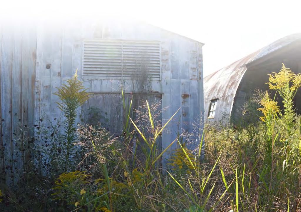
2 PROJECT BACKGROUND DEVELOPMENT OPPORTUNITIES This project strives to connect St. Francisville s downtown Historic District to the Mississippi River through river tourism, redevelopment, and strategic urban planning while maintaining the rural character and cultural charm of West Feliciana Parish. Over the years, St. Francisville has lost much of its connection to the Mississippi River. With more river-centric tourism and new dock facilities being planned, coupled with the growing popularity of the area, St. Francisville has the opportunity to grow in a way that renews its connection to our most underutilized asset, the Mississippi River. The St. Francisville Area Foundation envisions a redevelopment that engages the community and includes housing, eco-restoration and conservation, recreation, cultural, civic, and commercial uses that are appropriate for the context, character, and market demand in our area. The site contains vast, wide open buildings in a prime location that are suitable for a number of adaptive reuses. Stakeholders suggested a number of uses for the buildings, including retail space, a hotel, and restaurants. The School Board-owned property uphill from the main site is suitable for a unique residential development that fits in with character of the surrounding area and maximizes shared green and conservation spaces by clustering development. STAKEHOLDER INPUT Much of the site sits within the 100-year floodplain. This informs a limited type of development for this area. A large area of the site is well-suited for habitat restoration and activities such as hiking and birding that limit impact on this environmentally sensitive area. The site s high elevation has the potential to offer sweeping views of the Mississippi River. Selective clearing of vegetation in a few key areas will open up these views that are currently obscured. THINGS THAT MAKE ST. FRANCISVILLE UNIQUE: History and culture Eco-tourism River views Topography Access to the river without levees Quiet, friendly- the people Scenic Bayou Sara Power of the Mississippi River THINGS THAT ST. FRANCISVILLE DOES WELL: Health and wellness Food Music Nature Recreation History and culture KNOWN ISSUES: Traffic flow- especially trucks from the Corps facility Connection to downtown Hydrology BIG IDEAS FOR THE SITE: Restaurants/food service Residential development Wedding venue Some parking Retreat/meeting venue Shopping Open air market (fish, farmers, art, antiques, etc.) Recreational outfitters Recreational space- trails, fishing, birding Boutique hotel Ways to connect to town (River Rd., Prosperity St., Pecan Grove) Cater to day trippers Retreat spa Event space Connect to bike path- River Rd. to Thompson Creek, Sports Park, Tunica Hills Overlooks- places to just watch the river go by Raised boardwalk to river Adventure-based activities Bring back fire tower- views Public reservoir Habitat restoration, wetland preservation for flood storage 2011 flood level Property Line River View Developable land Developable, with limitations River View Developable, with limitations Best for conservation, recreation Developable land Here, the development potential for each area of the site is highlighted. The dashed blue line shows the extent of flooding in flood level
 6. Boutique hotel (40 rooms, 3000 SF meeting space) 7. Bluff-side cabins (11) 8. Event space 9. Pond and bird habitat 10. Wetland habitat restoration 11.")
3 PROPOSED DEVELOPMENT MAP KEY Feliciana St Single family residential (41 lots in a PUD cluster development) 2. Brewery (23000 SF) 3. Restaurant/Brewpub (9000 SF) 4. Retail (23400 SF) 5. Recreational outfitter (8000 SF) 6. Boutique hotel (40 rooms, 3000 SF meeting space) 7. Bluff-side cabins (11) 8. Event space 9. Pond and bird habitat 10. Wetland habitat restoration 11. Forested slopes with hiking trails 12. US ACE Mississippi River Museum 13. Boardwalk connection between residential area above and restaurant below Ferdinand St. Feliciana St Royal St. 9 8 Prosperity St.
: Eco-tourism is an ever-growing")


: Opportunities for commercial development include")


4 PROPOSED PROGRAM ELEMENTS AND INSPIRATION Jester King Brewery, Austin, TX Jester King Brewery, Austin, TX ECO-TOURISM (right): Eco-tourism is an ever-growing industry in St. Francisville and the Felicianas. With this site situated between town, the Mississippi River, and Bayou Sara with Cat Island beyond, it is an ideal spot to create a hub where adventurers can begin and end their trip to the area. The plan proposes a number of facilities that cater to day trippers and weekenders, including a recreational outfitter with equipment rentals, bluff-side cabins, and plenty of space for hiking, fishing, birding, and boating. COMMERCIAL DEVELOPMENT (above): Opportunities for commercial development include a brewery, restaurant, retail space, boutique hotel, and meeting space, along with a suitable amount of parking for these uses. The envisioned development is complementary to the easy-going and nature-focused quality of the town. The character of any development on this site should be in keeping with the small town charm and scale of the surrounding St. Francisville community. RESIDENTIAL DEVELOPMENT (below): Given the surrounding residential development, a similar quality is proposed for the School Board site. A cottage court layout, would allow for smaller homes and lots with shared green spaces. In general, the residential areas would minimize the footprint of the development, leaving much of the land in conservation for public use. RECREATION AND PRESERVATION (below): A large portion of the property sits in the Mississippi River flood plain, which limits most types of development, but makes is suitable for habitat restoration. Proposed elements here include a large pond, rookery, wetland habitat restoration, and hiking trails throughout. Porch House, Lake Flato Architects Greenwood Avenue Cottages, Shoreline, WA Blackberry Farm, Walland, TN Conservation Design Community, Looney Ricks Kiss Architects


5 PROJECT FUNDING OPTIONS There are various ways to fund the St. Francisville Riverfront Redevelopment Plan, though ideally, it would be a public-private partnership where governmental entities, non-profits and private developers work together and pool resources to fund and develop the property. Below is a list of some of those entities and funding programs that may be pursued for this project. 1. Corps of Engineers Water Resources Programs - contact: Nick Sims; website: mvn.usace.army.mil Corps funding can be used for design and permitting for projects that restore ecosystems, improve river navigation, and manage flooding risk. These program funds cannot be used for construction. While there is not a separate program for recreation, recreational aspects can be a part of the Corps project and funding. Planning Assistance to States Program 50/50 match up to $200,000 Will get fund work all the way through bid documents Can be used for shared use path Continuing Authorities Program (recommended by Nick Sims) Standing authority to go to construction for projects up to $15M Section 107 Small Navigation Projects can be used for navigation improvements for cruise ships and mat field access Section 206 Ecosystem Restoration Projects 50/50 match for feasibility, 65/35 match for design and implementation up to $10,000,000 federal funds Can be used for restoration of degraded freshwater wetlands ecosystem 10% of funds can go toward recreation (boat dock, trails, pavilion, benches, etc.) Provides feasibility alternatives Section 205 Small Flood Risk Management Projects can be use for a levee 2. Federal Highway Administration (FHWA) Recreational Trails Program for Louisiana (RTPL) - contact: Michael Domingue; website: crt.state.la.us/parks/ioutdoorrec.aspx Federal-aid assistance program to help States provide and maintain recreational trails for both motorized and non-motorized recreational trails use. The program provides funds for all kinds of recreational trail uses, such as hiking, running, wheelchair use, bicycling, in-line skating, equestrian use, off-road motorcycling, all-terrain vehicle riding, etc. 3. Land and Water Conservation Fund (LWCF) - website: LWCF provides matching grants to States and local governments for the acquisition and development of public outdoor recreation areas and facilities. 4. State Commercial Tax Credit Program website: crt.state.la.us/cultural-development/historic-preservation/tax-incentives/ A 25% state income tax credit for the rehabilitation of historic, income-producing buildings that are determined by the Division of Historic Preservation to be certified historic structures, generally over 50 years old. 5. West Feliciana Parish - contact: President Kevin Couhig State capital outlay funds of $1.6 M plus $400,000 local match that could be used for welcome center, dock and road improvements (line of credit approved for $200,000) Work with Corps and mat field contractor to resurface levee road 6. City of St. Francisville General funds for drainage infrastructure improvements 7. Tax Increment Financing (TIF) Public financing used to subsidize infrastructure for development by diverting projected future property tax revenue increases from an area. 8. Private developers Capital for development of buildings, parking, landscaping, housing, etc. 9. Private non-profits Continued support from St. Francisville Area Foundation and other private non-profits FOR MORE INFORMATION, CONTACT: Lauren Field, Executive Director P.O. Box 797 St. Francisville, LA stfrancisvilleaf.org executivedirector@stfrancisvilleaf.org PREPARED BY:
Wisconsin downtown action council Downtown project case study profile
 Wisconsin downtown action council Downtown project case study profile Project Name Onalaska Waterfront Project Location City of Onalaska Project Type (check all that apply) g Residential g Commercial g
LPC Goals and Strategies. Transportation and Connectivity Employment Opportunities Food Access Waterfront Access Livable Communities
 LPC Goals and Transportation and Connectivity Employment Opportunities Food Access Waterfront Access Livable Communities Transportation and Connectivity Goal: Safe and ready access of all types allowing
Mendota Heights 2040 Comprehensive Plan Draft Vers
 4 Parks and Trails The City of Mendota Heights boasts a variety of recreational and open space opportunities. Few cities can claim access to regional trails, riverside and lakeside parks, scenic bluffs
Provide and maintain sufficient public parks, recreation facilities, and open space to meet the recreational needs of County residents and visitors.
 (ROS) Goal Provide and maintain sufficient public parks, recreation facilities, and open space to meet the recreational needs of County residents and visitors. OBJECTIVE ROS.01 The County shall acquire,
A Vision for Walnut Creek
 A Vision for Walnut Creek Photo: City of Clive Walnut Creek Booklet 8 of 8 Greater Des Moines Water Trails and Greenways 1 Table of Contents Booklet 1: Water Trails Strategies and Policies Booklet 2: Beaver
{Best Practices. Summary of Tools, Strategies and Best Practices from 11 Michigan Case Study Communities
 Case Studies Michigan Coastal Community Working Waterfronts { Summary of Tools, Strategies and from 11 Michigan Case Study Communities Table of Contents Zoning...2 Community and Stakeholder Collaboration
Yadkin River Greenway Feasibility Study Fact Sheet Village of Clemmons, Town of Lewisville, Town of Bermuda Run
 Fact Sheet Village of Clemmons, Town of Lewisville, Town of Bermuda Run Project Background The Yadkin River Greenway Feasibility Study is a joint project with the Village of Clemmons, the Town of Bermuda
DISCUSSION TOPIC: ST JOHNS RIVER & ITS TRIBUTARIES (BPII) 2030 COMPREHENSIVE PLAN POLICES AND REGULATORY FRAMEWORK
 2030 COMPREHENSIVE PLAN POLICES AND REGULATORY FRAMEWORK") DISCUSSION TOPIC: ST JOHNS RIVER & ITS TRIBUTARIES (BPII) 2030 COMPREHENSIVE PLAN POLICES AND REGULATORY FRAMEWORK St. John s River & Its Tributaries Issue Summary: The St. Johns River is an important
DISCUSSION TOPIC: ST JOHNS RIVER & ITS TRIBUTARIES (BPII) 2030 COMPREHENSIVE PLAN POLICES AND REGULATORY FRAMEWORK St. John s River & Its Tributaries Issue Summary: The St. Johns River is an important
Great Rivers Greenway CLEAN GREEN CONNEC TED T RAILS
 Great Rivers CLEAN GREEN CONNEC TED T RAILS Great Rivers (GRG) was established in 2000 to create a clean, green, connected St. Louis region. Today, many new and exciting projects demonstrate the social,
Comprehensive Plan ADOPTED APRIL 2014
 Comprehensive Plan ADOPTED APRIL 2014 8 8. Outstanding Recreational & Cultural Opportunities We are proud of our community s parks and recreation system. Our community will ensure that the legacy of our
MARINA MARKET & WATERFRONT DEVELOPMENT STUDY PORT ARANSAS, TEXAS
 MARINA MARKET & WATERFRONT DEVELOPMENT STUDY PORT ARANSAS, TEXAS FEBRUARY 2015 PRESENTATION OUTLINE 1 2 3 4 5 6 7 REGIONAL POSITIONING SITE IMPRESSIONS PLANNING & DESIGN PRINCIPLES EXISTING IMPROVEMENTS
Illustration of Eastlake Farmer s Cooperative Grain Elevator. Chapter 5: implementation 5-1
 Illustration of Eastlake Farmer s Cooperative Grain Elevator Chapter 5: implementation 5-1 chapter 5: implementation Introduction The Eastlake Subarea Plan includes a wide range of recommendations intended
The Vision. Photo provided by The Minervini Group. 46 Vision, Objectives & Strategies
 Vision, Objectives & Strategies The is the public framework and guide for future development of the Grand Traverse Commons. The establishes public polices for infrastructure, the preservation of natural
TOWN COUNCIL / PLANNING COMMISSION
 Workshop #3 TOWN COUNCIL / PLANNING COMMISSION January 20, 2011 Consultant Team In Attendance Tonight BMS Design Group Nevada City and San Francisco Michael Smiley, AICP, ASLA Partner-in-Charge Nancy L.
10.0 Open Space and Public Realm
 10.0 Open Space and Public Realm 10.0 Open Space and Public Realm The Public Open Space System is comprised of: outdoor spaces available for public use that are either publicly owned (e.g., parks and
Food Innovation Districts An Economic Gardening Tool. Patty Cantrell Sarah Lucas Lakes to Land November 14, 2012
 Food Innovation Districts An Economic Gardening Tool Patty Cantrell Sarah Lucas Lakes to Land November 14, 2012 Provide services to local governments in 10-county region Planning master plans, recreation
Town of Peru Comprehensive Plan Executive Summary
 Town of Peru Comprehensive Plan Executive Communities that plan grow by choice, not by chance. A plan makes growth thoughtful, understandable, and predictable. A plan shows that a community is managing
INTEGRATING FAST FERRY SERVICE IN WOODBRIDGE
 INTEGRATING FAST FERRY SERVICE IN WOODBRIDGE TECHNICAL ASSISTANCE PANEL DECEMBER 12, 2018 MONTH DATE YEAR Urban Land Institute The mission of the Urban Land Institute is to provide leadership in the responsible
This page intentionally blank.
 This page intentionally blank. Parks, Recreation, and Open Space Chapter Relationship to Vision Vision Parks, Recreation and Open Space Chapter Concepts County Government. County government that is accountable
Best Practices Appendix: Waterfront Communities
 Redevelopment Ready Communities Best Practices Appendix: Waterfront Communities revised September 2014 Waterfront RRC defined The purpose of these additional criteria is to provide waterfront communities
UPPER BRODHEAD CREEK PARADISE CREEK GREENWAY PLAN
 UPPER BRODHEAD CREEK PARADISE CREEK GREENWAY PLAN The Upper Brodhead & Paradise Creeks Greenway Cooperating Municipalities Mount Pocono Borough Paradise Township Barrett Township Price Township Funding
Economic Redevelopment of Underutilized Parcels. May 16, 2012 Northland Arboretum Brainerd, Minnesota
 Economic Redevelopment of Underutilized Parcels May 16, 2012 Northland Arboretum Brainerd, Minnesota Matt Glaesman City of St. Cloud Community Development Director 1. A Tradition of Change 2. Why Now?
CHAPTER 3 VISION, GOALS, & PLANNING PRINCIPLES. City of Greensburg Comprehensive Plan. Introduction. Vision Statement. Growth Management Goals.
 CHAPTER 3 VISION, GOALS, & PLANNING PRINCIPLES Introduction The Greensburg Comprehensive Plan is intended as a working community document. A combination of long and short-term goals, this document is intended
Cumberland Region Tomorrow is a private, non-profit, citizen based regional organization working with Greater Nashville Regional Council
 Cumberland Region Tomorrow is a private, non-profit, citizen based regional organization working with Greater Nashville Regional Council and others in the public and private sectors, dedicated to planning
PLANNING ADVISORY BOARD AGENDA OCTOBER
 ! City of Langley PLANNING ADVISORY BOARD AGENDA OCTOBER 1, 2014 3-5pm LANGLEY CITY HALL - 112 2 nd Street, Langley WA 1) Call to Order and Roll Call 2) Approval of the Minutes September 10, 2014 3) Public
CHAPTER 7: Transportation, Mobility and Circulation
 AGLE AREA COMMUNITY Plan CHAPTER 7 CHAPTER 7: Transportation, Mobility and Circulation Transportation, Mobility and Circulation The purpose of the Transportation, Mobility and Circulation Chapter is to
MONTGOMERY COUNTY METRO STATION AREA DESIGN CHARRETTE
 MONTGOMERY COUNTY METRO STATION AREA DESIGN CHARRETTE Shady Grove Metro Station Area Charrette Closing Presentation October 25-28, 2000 MONTGOMERY COUNTY, MD M-NCPPC Design Collective, Inc. Architects
CHAPTER 1 Introduction
 CHAPTER 1 Introduction From sea to summit, Lane County covers almost 4,800 square miles of diverse Oregon landscape. Stretching from the Pacific Ocean through the Coastal Range, the Willamette Valley to
Examples of Asset Based Approaches to Development. Economic and Community Development Suffield, CT
 Examples of Asset Based Approaches to Development Presented by: Patrick McMahon, Director of Economic and Community Development Suffield, CT Neighborhood Commercial Development Wilson, CT Issues Elevated
EL DORADO COUNTY GENERAL PLAN PARKS AND RECREATION ELEMENT PRINCIPLE INTRODUCTION STATE AUTHORIZATION
 EL DORADO COUNTY GENERAL PLAN PARKS AND RECREATION ELEMENT PRINCIPLE The General Plan must identify the types of governmental services, including parks and recreation facilities, which are necessary to
Draft Stillwater 2030 Comprehensive Plan- Goals and Policies
 Draft Stillwater 2030 Comprehensive Plan- Goals and Policies Instructions- Review each goal and policy and discuss with group any changes, deletions for additions to the list using your groups pen. Keep
3. VISION AND GOALS. Vision Statement. Goals, Objectives and Policies
 Vision Statement Queen Creek s interconnected network of parks, trails, open spaces and recreation opportunities provide safe and diverse activities and programs that sustain its unique, small town, equestrian
Pedestrian and Bike Bridge LOGO
 6.2.2 Pedestrian and Bike Bridge The proposed pedestrian and bike crossing re-envisions the existing bridge at Pismo Creek on Cypress Street. The bridge is currently underutilized by vehicular through
Public responses to the question what do you want Muscatine to be, 20 years from now? (Responses were categorized as follows)
") Mississippi Drive Kickoff Event 9/1/2015 Blue Zones Kickoff Presentation Public responses to the question what do you want Muscatine to be, 20 years from now? (Responses were categorized as follows) Physical
Mississippi Drive Kickoff Event 9/1/2015 Blue Zones Kickoff Presentation Public responses to the question what do you want Muscatine to be, 20 years from now? (Responses were categorized as follows) Physical
Pine Flat Lake Master Plan Update FACT SHEET September 2014
 Pine Flat Lake Master Plan Update FACT SHEET September 2014 PURPOSE AND OBJECTIVE The U.S. Army Corps of Engineers Sacramento District is revising the 1976 Pine Flat Lake Master Plan and is seeking public
Previous Stakeholder Meetings
 Titusville Tomorrow Previous Stakeholder Meetings Workshop 1 SWOT CVS Workshop 2 SWOT and CVS Results Value of Place Based Design 3 Table Top Designs The Waterfront The Gateways The Downtown Key Points
SCC PRD (2016) COUNTY PARK MASTER PLAN
 COUNTY PARK MASTER PLAN") SCC PRD (2016) COUNTY PARK MASTER PLAN MASTER PLAN UPDATE PARKS AND RECREATION COMMISSION NOVEMBER 7, 2018 PURPOSE OF THE MASTER PLAN The Sanborn County Park Master Plan will provide the Department with
SCC PRD (2016) COUNTY PARK MASTER PLAN MASTER PLAN UPDATE PARKS AND RECREATION COMMISSION NOVEMBER 7, 2018 PURPOSE OF THE MASTER PLAN The Sanborn County Park Master Plan will provide the Department with
LAND USE PLAN 7. Housing
 21 LAND USE PLAN While the land uses that have historically dominated the Corridor itself have been industrial/commercial, the Master Plan proposes a shift to mixed-use redevelopment, complimented by a
The following principles guide the development of goals and strategies to protect and promote these amenities:
 OPEN SPACE/PARKS/TRAILS/RECREATION GOALS/STRATEGIES Cherry Hills Village is a living environment that offers low density development, open areas, public scenic vistas, public trails and public parks. This
Gold Line Bus Rapid Transit Transit Oriented Development (BRTOD) Helmo Station Area Plan
 Helmo Station Area Plan") Appendix F Gold Line Bus Rapid Transit Transit Oriented Development (BRTOD) Helmo Station Area Plan Introduction and Purpose of the Plan The Gold Line Bus Rapid Transit facility is an eleven-mile dedicated
Appendix F Gold Line Bus Rapid Transit Transit Oriented Development (BRTOD) Helmo Station Area Plan Introduction and Purpose of the Plan The Gold Line Bus Rapid Transit facility is an eleven-mile dedicated
Village of Fair Haven Goals & Objectives
 Village of Fair Haven Goals & Objectives 1 Natural Environmental Quality & Aesthetics Embrace policies and programs that preserve and enhance the Village s natural resources, environment, water quality,
Town of Rico Three Mile Plan for Annexation
 Town of Rico Three Mile Plan for Annexation 10.20.2010 Adopted by Resolution 2010-2 Produced with funding support from the Colorado Department of Local Affairs 2 Content Guide Introduction. 3 Annexation
The Value Proposition of New Urban Parks in Small Cities: Exploring Newburgh, New York as a Prototypical Case Study
 The Value Proposition of New Urban Parks in Small Cities: Exploring Newburgh, New York as a Prototypical Case Study By Arianna Koudounas Georgetown MURP December 2015 SAFE HARBORS GREEN Newburgh, NY NOW
Chapter 11. Implementation Plan
 Chapter 11 Implementation Plan 127 D O W N T O W N T AV A R E S R E D E V E L O P ME N T MA S T E R P L A N IMPLEMENTATION PLAN This section shows how the Master Plan translates to a phased series of
Executive Summary Purpose of the Plan Defining Open Space and Greenways
 Executive Summary Bucks County possesses a vast array of open space resources including natural areas, parks, farmland and historic and cultural resources that contribute to a high quality of life valued
6. RECREATION AND OPEN SPACE ELEMENT
 6. RECREATION AND OPEN SPACE Introduction This Recreation and Open Space Element includes Goals, Objectives and Policies (GOP) that apply to the main campus in Gainesville and the Lake Wauburg Recreation
Robbinsdale LRT Station. CDI Development Guidelines. August Overview
 Robbinsdale LRT Station August 2018 Overview The City of Robbinsdale may have the coolest opportunity site along the 13 mile stretch of the Bottineau LRT corridor / Blue Line extension. Located a block
Highbridge Park Enhance the picturesque park: Provide more opportunities for healthy activity: Improve forest and ecology health:
 Enhance the picturesque park: Expose gigantic rocks and meadows Provide more opportunities for healthy activity: Improve the recreation center, athletic fields, playgrounds & restrooms Improve forest and
Roosevelt Corridor. R e i n v e s t m e n t P l a n. Public Meeting Gilbert Elementary School May 12, :00 pm
 Roosevelt Corridor R e i n v e s t m e n t P l a n Public Meeting Gilbert Elementary School May 12, 2009 6:00 pm Agenda 6:00 6:10 6:25 6:40 6:55 7:00 Opening Comments Councilwoman Jennifer V. Ramos District
RECREATION, OPEN SPACE AND GREENWAYS ELEMENT GOALS, OBJECTIVES, AND POLICIES
 RECREATION, OPEN SPACE AND GREENWAYS ELEMENT GOALS, OBJECTIVES, AND POLICIES GOAL R-1: DEVELOP A RECREATION, OPEN SPACE AND GREENWAYS SYSTEM AS AN INTEGRAL COMPONENT OF AN OVERALL, COUNTY-WIDE ECONOMIC
MCCOYS CREEK RESTORATION 30% DESIGN
 MCCOYS CREEK RESTORATION 30% DESIGN THE MCCOYS CREEK RESTORATION PLAN The restoration plan aims to reduce flooding, restore ecosystem health, expand recreational opportunities along the creek, and connect
Bourne Downtown Site Planning
 Prepared for: The Town of Bourne, MA In Cooperation with: Bourne Financial Development Corporation Prepared by:, Inc. June 24, 2009 Table of Contents Introduction and Summary... 1 Site Existing Conditions...
Introducing the Main Street Strategic Toolbox
 Ulster County Main Streets: A Regional Approach Ulster County Planning Department, 244 Fair Street, Kingston NY 12401 Why do we take a regional approach to Main Streets? There are many different approaches
PARK & RECREATION. Project Summaries
 PARK & RECREATION Project Summaries 45 BEAVER ISLAND TRAIL EXTENSION - PHASE VIII - 60TH ST S TO CITY LIMITS Project Number: PK.19.01 Construction Year: 2019 quality services to area residents who utilize
A BLUEPRINT FOR BROCKTON A CITY-WIDE COMPREHENSIVE PLAN
 A BLUEPRINT FOR BROCKTON A CITY-WIDE COMPREHENSIVE PLAN Public Meeting October 2016 1 Plan Summary and Discussion Public Meeting May 4 2017 City of Brockton Bill Carpenter, Mayor Department of Planning
Planning for Waterfront Communities
 Planning for Waterfront Communities Redevelopment Ready Communities Supplemental Training Program OFFICE OF THE GREAT LAKES Waterfront Community Best Practices and Guidelines New supplemental criteria
MPO UPDATE. Metro Advisory Committee. August 8, 2017
 MPO UPDATE Metro Advisory Committee August 8, 2017 Iowa Data Bike 1 2 3 4 Greater Des Moines Water Trails and Greenways Master Plan MPO Strategic Plan QUESTIONS? Photo Credit: Maharry Photograpy, 2014
LAND USE ELEMENT. Purpose. General Goals & Policies
 LAND USE ELEMENT Purpose This Land Use Element contains the goals and policies necessary to support the City s responsibility for managing land resources and guiding development through implementing regulations,
Making Transit Oriented Development Work For Boonton, NJ
 Making Transit Oriented Development Work For Boonton, NJ Bloustein School of Planning and Public Policy Studio Dan Burton Loannie Dao Webster Slater Brandon Williams Ian Watson Maria Laham Nicola Mammes
City of Brevard 2015 Comprehensive Plan
 City of Brevard 2015 Comprehensive Plan Plan Functional Elements Arts & Culture Brevard enjoys a rich mix of artistic and cultural resources, from music venues to historic sites to multi-day festivals.
Warren County/Bowling Green Focus 2030 Comprehensive Plan VOLUME 1 INDEX
 Appendix 5: Index VOLUME 1 INDEX A Aesthetics ES-6, FLU-15, FLU-17, FLU-24, NCR-7 Agricultural Base FLU-18, FLU-20 Agricultural Centers, Rural FLU-11 Agricultural District NCR-17-NCR-18 Agricultural Economy
I. STAFF POLICY RECOMMENDATIONS. The following RMP policy strategies are proposed by staff in support of a Scenic Resource Protection Program:
 Policy Consideration: Scenic Resource Protection Program Status: For Consideration by the Highlands Council at September 14, 2006 Work session Date: September 12, 2006 I. STAFF POLICY RECOMMENDATIONS The
THE POLICY FRAMEWORK FOR WALKABLE COMMUNITIES. Community Technical Assistance Program Building Active Communities Institute March 2016
 THE POLICY FRAMEWORK FOR WALKABLE COMMUNITIES Community Technical Assistance Program Building Active Communities Institute March 2016 ACTIVE COMMUNITIES BACK THEN ACTIVE COMMUNITIES BACK THEN Lifestyle
Coast Highway Oceanside, California
 Coast Highway Oceanside, California Coast Highway Plan Zones What We ve Heard - Walkable/Bikeable Community (Senior and Child Friendly) -Wider Sidewalks -Street Trees -Traffic Calming -Bike Lanes -Paseos
SAN RAFAEL GENERAL PLAN 2040 INTRODUCTION AND OVERVIEW
 SAN RAFAEL GENERAL PLAN 2040 INTRODUCTION AND OVERVIEW Steering Committee Presentation February 14, 2018 Purpose of General Plan Guide land use and development decisions Coordinate transportation, infrastructure,
Reconnecting to a Forgotten River St. Cloud MN. Aaron Hanson Design Design Thesis LA 572, Thesis, Spring 2012
 Reconnecting to a Forgotten River St. Cloud MN Aaron Hanson Design Design Thesis LA 572, Thesis, Spring 2012 site context 2.5 Miles Sartell St. Cloud to Fargo 170 Miles (2 hrs 45 mins) Hwy 10 infrastructure
RECREATION AND OPEN SPACE ELEMENT GOALS, OBJECTIVES, AND POLICIES
 RECREATION AND OPEN SPACE ELEMENT GOALS, OBJECTIVES, AND POLICIES Goal 7 To provide park facilities, recreation programs, and open space resources that are safe, adequate, and accessible to all City residents,
Erik Rundell, Project Manager
 Erik Rundell, Project Manager M.U.R.P., Portland State University Certificate, Commercial Real Estate, University of Washington Graduate Certificate, GIS, University of Wisconsin-Madison B.A. Geography,
Civic Center District
 Civic Center District The Civic Center district is the civic and social heart of Warrenville, containing such public buildings as the City Hall, Warrenville Public Library, Police Station, Park District
Town of Washington Master Plan & Regulatory Audit: Interim Results
 Town of Washington Master Plan & Regulatory Audit: Interim Results May 20, 2008 Presented by: 30 Bank Street Lebanon, NH 03766 www.uvlsrpc.org Introduction & Purpose Compare the Master Plan to the regulations
2.0 AREA PLANS. Lakeside Business District. Lakeside Business District Land Use Categories:
 Lakeside Business District Lakeside Business District Land Use Categories: Campus Commercial Campus Commercial means a mixture of uses which includes corporate offices, office parks, hotels, commercial,
2030 Comprehensive Plan VISION STATEMENT
 RESOURCE DOCUMENT for Steering Committee Meeting #2 July 12, 2017 2030 Comprehensive Plan VISION STATEMENT Steering Committee from 2008 Established the Lauderdale s Vision as: Creating a livable, lovable
SECTION 9 PUBLIC FORUM DRAFT 5/31/2017 SEVEN YEAR ACTION PLAN
 SECTION 9 SEVEN YEAR ACTION PLAN The Seven-Year Action Plan addresses the objectives of the Open Space and Recreation Plan and identifies actions to meet these objectives. While the Open Space and Recreation
Chapter 5: Recreation
 Chapter 5: Recreation Introduction and Setting Recreational opportunities within Nevada County are varied, ranging from public parks with intensively used active recreational facilities, to vast tracts
City of Iowa City Department of Neighborhood and Development Services Department of Parks and Recreation Department of Public Works City Manager s
 RFP Pre-submittal meeting December 18, 2015 City of Iowa City Department of Neighborhood and Development Services Department of Parks and Recreation Department of Public Works City Manager s Office Background
Master Plan Objectives and Policies
 Master Plan Objectives and Policies Introduction This chapter identifies the Park issues and recommended policies established by this Master Plan. The issues were identified through meetings with staff,
THE TOWN OF WASAGA BEACH
 THE TOWN OF WASAGA BEACH Downtown Development Master Plan Committee of the Whole Presentation January 26 th 2017 Uses within this designation should reflect a dependence on tourism as opposed to the permanent
Land. Planning. Michael Versen & Associates Landscape Architecture Land Planning
 Michael Versen & Associates Landscape Architecture Land Planning 299 N. Weisgarber Road Suite 201 Knoxville, TN. 37919 website: www.versenassociates.com telephone: 865-588 588-1331 fax: 865-251 251-4086
Objective: Resolution to recommend adoption of the Big Thompson Assessment to the Planning Commission
 Type of Meeting: Administrative Matters Name of requestor: Zac Wiebe - 619-4534, Kerri Rollins - 619-4577, Gary Buffington - 619-4560 Department: Natural Resources Preferred appearance date: 8/18/2015
Methuen Technical Assistance Panel, June 18, 2015! City of Methuen, Massachusetts!
 Methuen Technical Assistance Panel, June 18, 2015 City of Methuen, Massachusetts Methuen Technical Assistance Panel, June 18, 2015 About ULI the Urban Land Institute Mission To provide leadership in the
Chapter 3. Community Vision and Goals
 Chapter 3. Community Vision and Goals 3.1 Public Involvement Charlevoix s master plan was prepared in a way that maximized public participation. Dating back to 2004, the Planning Commission and staff held
Ivywild On The Creek PRELIMINARY CREEK DISTRICT MASTER PLAN
 Ivywild On The Creek PRELIMINARY CREEK DISTRICT MASTER PLAN Introduction: Rejuvenating an extraordinary Creekside neighborhood THE CREEKSIDE DISTRICT The Ivywild On The Creek Neighborhood District Master
INTRODUCING THE BALTIMORE CITY GREEN NETWORK VISION PLAN
 INTRODUCING THE BALTIMORE CITY GREEN NETWORK VISION PLAN GOALS OF THE GREEN NETWORK PLAN Protect and enhance the unique ecological resources of our city Support economic growth and sustainable redevelopment
Brockholes Wetland and Woodland Nature Reserve, Preston Lancashire
 Newlands Brockholes Wetland and Woodland Nature Reserve, Preston Lancashire Nature s Gateway to Lancashire NEWLANDS Brockholes: site profile Brockholes Wetland and Woodland Nature Reserve project area
1. Parks & Recreation Neighborhood Parks Community Parks Special Use Sites 2. Open Space 3. Trails
 Appendix A: Park Classifications The intent of parks and recreation classifications is to aid in making acquisition and design decisions for park sites, facilities and the organization of recreation space
PARKS AND RECREATION
 PARKS AND RECREATION WHAT YOU WILL FIND IN THIS CHAPTER: Background information on the development of the Park, Recreation, and System Plan (PRSP). General overview of Ellensburg s parks and recreation
Strategic Target: Utilize Pay-For-Use Services Whenever Possible
 2004 Strategic Planning Report The 2003 Strategic Planning Steering Committee compiled and presented this report to the Olathe City Council on March 25, 2004. This is the result of community meetings conducted
Regulation Changes for Open Space and Similar Uses
 Regulation Changes for Open Space and Similar Uses What is the Project? This project is an analysis of the Zoning Ordinance relating to public lands and open space regulations. The proposed text amendments
4 Park Planning and Design
 4 Park Planning and Design Park Constellations Elliot Gateway/Mills Loring North Loop Commons Twins Minneapolis Park & Recreation Board Downtown Service Area Master Plan 4-1 PROJECT APPROACH REFERENCE
Waterfront Development Master Plan
 PORT of VANCOUVER USA Vancouver, WA Waterfront Development Master Plan DRAFT - FINAL CONCEPTUAL MASTER PLAN PROJECT TEAM NBBJ Heritage Research Associates JLA Kittelson Associates Leland Consulting Group
03 HIGH PRIORITY SITES
 03 HIGH PRIORITY SITES HOWARD PARK Howard Park is one of South Bend s largest riverfront parks, hosting nearly acres. Howard Park has a very passive landscape with a recreation building, ice skating rink,
RECREATION AND OPEN SPACE VISION
 City of South Lake Tahoe General Plan Policy Document Recreation and Open Space Element INTRODUCTION This element provides the policy context for the City of South Lake Tahoe to achieve its vision for
Visioning Statement and Guiding Principles
 Visioning Statement and Guiding Principles Planning for the Future The General Plan The General Plan represents Woodland's shared vision of the future and defines a path to lead the community toward its
Route 1 Corridor Study
 Route 1 Corridor Study Westbrook, Connecticut A Vision for the Connecticut Shoreline Public Informational Meeting July 28, 2015 Lower Connecticut River Valley Council of Governments Fitzgerald & Halliday,
Potential Green Infrastructure Strategies May 6, 2015 Workshop
 Potential Green Infrastructure Strategies May 6, 2015 Workshop Background The City of Cortland is developing the Tioughnioga Urban Headwaters Green Infrastructure Action Plan with funding from the National
a river of opportunity
 Kankakee Riverfront a river of opportunity Public Open House November 7, 2017 Can Kankakee use the river to connect its citizens? to support its economy? to attract more visitors? to reposition its brand?
HOLLERING PLACE MASER PLAN Concept for Development
 HOLLERING PLACE MASER PLAN Concept for Development Current Status of the Historic Hollering Place Development Project The city did not receive a responsive proposal for the Historic Hollering Place Development
Keyport. Vision for Keyport
 Keyport Vision for Keyport Keyport is a rural, historic waterfront village bounded and limited in size by its natural borders of water and the Naval Undersea Warfare Center. The community consists primarily
Parks, Trails, and Open space Element
 Parks, Trails, and Open space Element Parks, Trails, and Open Space element Parks, Recreation, and Open Space are important components of the quality of life desired by the residents of Elk Grove. This
Turkey Creek Streamway Corridor
 Turkey Creek Streamway Corridor Turkey Creek Corridor Overview History Watershed Corridor Inventory Coalition Corridor Plan Stages of Development Benefits Funding Turkey Creek History Kansas and Missouri