A citizen s guide to the. Comprehensive Plan. City of Lakeville, Minnesota 1
|
|
|
- Abel Charles
- 5 years ago
- Views:
Transcription


1 A citizen s guide to the Comprehensive Plan 2008 City of Lakeville, Minnesota 1
2 Introduction The City of Lakeville completed an update of its Comprehensive Plan in A comprehensive plan is a tool that guides day-to-day and future land use and public infrastructure decisions to provide managed growth throughout the City. The Comprehensive Plan includes the following elements: Comprehensive Land Use Plan Comprehensive Water Plan Comprehensive Sanitary Sewer Plan Comprehensive Transportation Plan Lakeville Parks, Trails and Open Space Plan Lakeville Water Resources Management Plan Lakeville s new Comprehensive Plan represents a collaborative effort by residents, property owners, the Planning Commission, and City Council to guide future growth and development throughout the City. Lakeville s current estimated population is approximately 55,000, making it the third largest city in Dakota County and the 16th largest city in the Twin Cities metropolitan area. Over the next 20 years Lakeville is anticipated to add approximately 33,800 new residents and become the largest city in Dakota County. Lakeville s Comprehensive Plan will serve as a guide to ensure high quality residential, commercial, industrial, and office developments as the City continues to grow into the future. If you have questions or comments, please contact the City of Lakeville Planning Department at (952) or send an to planninginfo@lakevillemn.gov. You may also review the full version of the documents listed above by visiting Lakeville s website at 2 A Regional Perspective In 2004 the Metropolitan Council developed the Regional Development Framework to serve as a guide for development in the Twin Cities seven county area. The Framework estimates that the region, between 2010 and 2030, will need to accommodate an additional: 966,000 people 563,000 jobs 471,000 households Lakeville is projected to accommodate approximately 33,800 or one in 16 of those new residents along with 16,360 or one in 19 new homes. The community is known as a desirable place to live and work because of the following factors: Accessibility to metro employment centers. Attractiveness and quality of residential, commercial, industrial, 100,000 and office developments. Excellent public schools. 90,000 Protection of natural resources. 80,000 Well-planned parks, open space, and 70,000 pedestrian trail systems. 60,000 One of the lowest tax rates in the metro area due to fiscal stability 50,000 through sound management 40,000 practices. 30,000 Availability of high-quality and wellmanaged public services. 20,000 A positive and receptive attitude 10,000 towards quality businesses and 0 industries. The Comprehensive Plan was updated to ensure ongoing high quality growth. During the comprehensive planning process, residents and property owners participated in more than 22 neighborhood meetings and open houses. Their input, along with that of the school districts, neighboring communities, Dakota and Scott Counties, and the Lakeville Planning Commission and City Council, shaped Lakeville s growth management strategy. This booklet offers a glimpse into the future as Lakeville moves forward through the 21st century. You will see the types of land uses that are planned, where they are expected to occur, and the anticipated timeline for development. City of Lakeville growth projections Population Households Employment
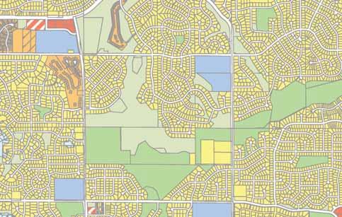
3 Land Use Planning Lakeville is approximately 38 square miles in area, encompassing nearly 24,464 square acres. As part of the Comprehensive Plan update, the City reviewed land use throughout the community and developed the 2030 Land Use Map, shown on the next page. The table below illustrates anticipated future land uses in 2030 based on the map, which is a generalized guide for future development patterns that may be refined and amended over time as community priorities evolve and the numbers shown in the table are adjusted accordingly: Land Use Category Percentage Acres Rural agriculture/residential 6.6% 1, Low-density residential 32.6% 7, Medium-density residential 7.7% 1, High-density residential 0.8% Manufactured housing 0.9% Commercial/retail 4.7% 1, Offi ce/industrial 7.5% 1, Airport 0.6% Restricted areas 5.6% 1, Special plan area 5.4% 1, Public and quasi-public 3.8% Public right-of-way 13.4% 3, Parks/open space 6.2% 1, Water 4.2% 1, Total 100% 24, Active farming operations and numerous hobby farms represent a valuable land use resource within the community. By the year 2030, over 6.6 percent of the community s more than 24,000 acres will remain agricultural or rural residential. A large portion of the agricultural area within the City falls within the Special Plan Area along Cedar Avenue. Specific land use designations within this area will be determined through a special study to be completed in the future, in order to be compatible with future bus rapid transit service. A blend of single-family homes and townhomes will be the predominant land uses over the next 20 years. The 2030 Land Use Plan also provides for a variety of housing types to conform to the Livable Communities Act and meet the needs of a range of lifestyles, economic levels, and age groups. The Land Use Plan identifies areas to accommodate varying housing densities. These designations take into consideration the community s transportation, parks and utility system plans, and the natural environment. The 2030 Land Use Plan also designates additional land for expansion of the community s commercial and industrial areas. Retail/commercial, office, and industrial development are more predominant, providing strong local economic benefits, employment centers, and services for the entire community. By building on the success of Airlake Industrial Park, First Park Lakeville, and Fairfield Business Campus, Lakeville is poised for further prosperity in the business, light manufacturing, and office land uses that help provide a stable tax base for the City. Commercial Development Broadens Tax Base Retail/commercial, office, and industrial businesses contribute significantly to the economic vitality of a community. The property taxes that Lakeville businesses pay lessen the tax burden of residents. Several projects that have been completed to date broaden and strengthen the tax base for everyone in the community. In 2005, Argonne Village, a retail/commercial development located along Kenwood Trail, just east of Interstate 35, was approved. This project includes approximately 138,000 square feet of retail, restaurant, and office uses, including a 73,281-square-foot Rainbow Foods grocery store. The Argonne Village project also spurred needed transportation improvements along the Kenwood Trail transportation corridor. Commercial development continues in Heritage Commons, located in the northeast corner of Kenwood Trail and Dodd Boulevard. Heritage Commons includes approximately 130,000 square feet of retail, office, and restaurant uses including a 69,680-square-foot Cub Foods grocery store. The Crossroads development has also continued to develop and now includes 149,171 square feet of retail, office, and restaurant uses. Several industrial parks are also in the process of developing and expanding. Airlake Industrial Park grew by 100 acres after the land was annexed into the City in First Park Lakeville consists of 130 acres, including the 285,000-square-foot Uponor facility and 282,000 square feet of office, warehouse, and manufacturing space. In addition to these larger industrial, office, and manufacturing parks, several smaller office/industrial developments are being developed throughout the City, providing an expanded tax base and a dynamic business community that provides opportunities for Lakeville residents to work within the community they live. The number of individuals to be employed by businesses within Lakeville by the year 2030 is projected to be approximately 27,400. 3
4 4
5 City of Lakeville 2008 Comprehensive Land Use Plan 2030 Land Use Plan Rural Density Residential - 1 dwelling per 10 acres Downtown Low Density Residential - Less than 3 dwellings per acre Low/Medium Density Residential - 3 to 5 dwellings per acre Medium Density Residential - 4 to 7 units per acre Medium/High Density Residential - 5 to 9 units per acre 205th St. Holyoke Ave. High Density Residential - More than 9 units per acre Manufactured Housing Office/Residential Transition Commercial Office Park Warehouse/Light Industrial 210 th St. Industrial Airport Public and Quasi-Public Parks Restricted Development 0 2,375 4,750 Feet Special Plan Area Water Source: City of Lakeville, MN Miles 2 Ê 1 December

6 A Growth Staging Plan To accommodate the community s forecasted growth through the year 2030, the City is expected to expand its Metropolitan Urban Service Area (MUSA) in several stages, as illustrated below. This staging will encourage in-fill development that utilizes in-place sanitary sewer and streets. By following this plan, the City will postpone costly investments in new infrastructure. Only land designated by the Metropolitan Council as being within the MUSA can receive sanitary sewer and water service. The Natural Environment To preserve Lakeville s small-town ambiance and natural amenities for future generations to enjoy, the City remains committed to protecting our valuable natural resources. Ongoing efforts include lake water quality protection, trout stream management, and household hazardous waste collection. Environmentally sensitive areas and open spaces help define the community s character and enhance the quality of life for all of us. Lakes, tributaries, bluffs, wooded areas, wetlands, and ponds are valuable for their role in storm water management, ground water recharge, nutrient assimilation, wildlife habitat, recreation, and aesthetic appeal. As Lakeville grows, maximum effort is being made to compatibly integrate land uses and new development with our natural environment. 6 Comprehensive Parks, Trails, and Open Space Plan Open space is a vital component of Lakeville s environment, with opportunities for recreation and leisure time activities playing an integral role in Lakeville s overall quality of life. More than 1,400 acres in 62 parks and public properties are available, including athletic fields, playgrounds, greenways, trails, tennis courts, skating rinks, picnic areas, conservation areas, nature areas, public fishing areas, and swimming beaches. There are more than 100 miles of pedestrian and bike trails. Also available are cross-country ski trails, snowmobile trails, nature trails, and equestrian trails.

7 Transportation Plan The Transportation Plan provides the policy and guidance needed to make appropriate transportation-related decisions to maintain and improve a comprehensive transportation system that is important to the ongoing economic health and quality of life within the City of Lakeville. The Transportation Plan is reviewed annually, in conjunction with the City s Capital Improvement Plan, to meet the transportation needs of Lakeville s growing community. The Transportation Plan also demonstrates how the City will provide for an integrated transportation system that will serve the future needs of its residents and businesses, support the City s development plans, and complement the portion of the metropolitan transportation system that lies within the City s boundaries. The plan includes goals, policies, roadway classifications, and design standards, as well as identifying future roadway system improvements. Priorities include: Focusing the transportation system on activity centers within Lakeville and in neighboring communities. Creating and implementing a Comprehensive Pavement Management Program. Providing local street networks to encourage interconnected neighborhoods by incorporating transportation planning with land use strategies. Incorporating urban streetscape designs to enhance the aesthetics of corridors and gateways. Participating in the I-35W Solutions Alliance (a joint powers board) to improve mobility in the I-35W corridor. Expanding transit service and constructing transit facilities (i.e., designated park and carpool and park and ride lots). Expanding pedestrian and bicycle trailways in conjunction with roadway improvements as well as residential, commercial, industrial, and office developments. Supporting Airlake Airport as a Metropolitan Airports Commission (MAC) reliever airport. 7


8 Zoning and Subdivision Ordinances Explained To ensure that future development continues to achieve the high quality expected by our residents, the City of Lakeville updated its Zoning Ordinance and zoning map in early The primary objective was to create an ordinance and map that accurately reflect the Comprehensive Plan and 2030 Land Use Plan approved in The Zoning Ordinance translates general guidelines contained in the Comprehensive Plan into specific performance and design standards within the zoning districts by controlling such things as: Type of use Building height Building materials Building setbacks Minimum lot area and lot width Off-street parking and loading Landscaping and screening Permanent and temporary signage Accessory buildings Fences and swimming pools Development of shoreland properties Grading and erosion control Home occupations The City of Lakeville also updated its Subdivision Ordinance in This ordinance is necessary to control and record the manner in which land is subdivided into smaller parcels, lots, or building sites so that the parcels may eventually be sold or developed. Developers are required to prove the proposed subdivision is not premature by demonstrating that adequate public facilities, such as storm water drainage, water, streets, and sanitary sewer exist to serve the proposed development. In addition, subdivisions must be consistent with the Comprehensive Plan and all minimum Zoning Ordinance lot area and width requirements. The Subdivision Ordinance also identifies standard design guidelines for all public infrastructure constructed within a development. A Citizen s Guide to the Comprehensive Plan Published by the City of Lakeville Holyoke Avenue, Lakeville, MN (952) planninginfo@lakevillemn.gov January 2010
Improve Neighborhood Design and Reduce Non Point Source Water Pollution
 HOW TO Planning Guide Improve Neighborhood Design and Reduce Non Point Source Water Pollution This document was funded by a grant from the New Hampshire Coastal Program with funding from the National Oceanic
Gold Line Bus Rapid Transit Transit Oriented Development (BRTOD) Helmo Station Area Plan
 Helmo Station Area Plan") Appendix F Gold Line Bus Rapid Transit Transit Oriented Development (BRTOD) Helmo Station Area Plan Introduction and Purpose of the Plan The Gold Line Bus Rapid Transit facility is an eleven-mile dedicated
Appendix F Gold Line Bus Rapid Transit Transit Oriented Development (BRTOD) Helmo Station Area Plan Introduction and Purpose of the Plan The Gold Line Bus Rapid Transit facility is an eleven-mile dedicated
CITY OF COLWICH COMPREHENSIVE PLAN LAND USE LAND USE 1
 LAND USE LAND USE 1 WHAT YOU WILL FIND IN THIS CHAPTER: Discussion of today s conditions and tomorrow s projections Discussion of challenges and opportunities Discussion of the environmental quality goals,
Corridor Vision. 1Pursue Minnehaha-Hiawatha Community Works Project. Mission of Hennepin County Community Works Program
 1Pursue Minnehaha-Hiawatha Community Works Project Minnehaha-Hiawatha Community Works is a project within the Hennepin Community Works (HCW) program. The mission of the HCW program is to enhance how the
CHAPTER 7: Transportation, Mobility and Circulation
 AGLE AREA COMMUNITY Plan CHAPTER 7 CHAPTER 7: Transportation, Mobility and Circulation Transportation, Mobility and Circulation The purpose of the Transportation, Mobility and Circulation Chapter is to
SECTION ONE: INTRODUCTION. introduction
 introduction 1 INTRODUCTION Since it was first established in 1843 as a trading post for the Hudson s Bay Company, Victoria has evolved into a Provincial capital city that is recognized across Canada and
SECTION II SECTION II STATEMENT OF GOALS, OBJECTIVES, PRINCIPLES, ASSUMPTIONS, POLICIES AND STANDARDS
 STATEMENT OF GOALS, OBJECTIVES, PRINCIPLES, ASSUMPTIONS, POLICIES AND STANDARDS 1 2 STATEMENT OF GOALS, OBJECTIVES, PRINCIPLES, ASSUMPTIONS, POLICIES AND STANDARDS INTRODUCTION The New Jersey Municipal
BROOKHILL NEIGHBORHOOD MODEL ZONING MAP AMENDMENT PREFACE TO APPLICATION
 BROOKHILL NEIGHBORHOOD MODEL ZONING MAP AMENDMENT PREFACE TO APPLICATION June 15, 2015 Revised: August 1, 2016 I. VISION Brookhill is a proposed community based upon the principles of Albemarle County
Chapter 2: Vision, Goals and Strategies
 Chapter 2: Vision, Goals and Lake Elmo Today & Tomorrow Comprehensive Plan 2040 2 VISION, GOALS & STRATEGIES - DRAFT 4-6-2018 INTRODUCTION Comprehensive Plan Purpose Perhapse the most important objective
Mendota Heights 2040 Comprehensive Plan Draft Vers
 4 Parks and Trails The City of Mendota Heights boasts a variety of recreational and open space opportunities. Few cities can claim access to regional trails, riverside and lakeside parks, scenic bluffs
Hopkins. Development Guidelines May Overview. Sponsored by: Blake Road Corridor Collaborative City of Hopkins
 Hopkins Blake Road LRT Station Area Development Guidelines May 2015 Sponsored by: Blake Road Corridor Collaborative City of Hopkins Overview Hopkins is a dynamic community of over 17,000 residents located
St. Louis Park Wooddale LRT Station Site development guidelines
 St. Louis Park Wooddale LRT Station Site development guidelines November 2013 OVERVIEW St. Louis Park s convenient location as a neighbor to Minneapolis means you re only minutes away from some of the
A. WHAT IS A GENERAL PLAN?
 I. Introduction A. WHAT IS A GENERAL PLAN? A general plan is the planning guideline for the future of a city. It contains goals and policies which regulate urban development, the protection of the natural
2040 LUP is a part of the Comprehensive Plan and carries the same legal authority. Economic Challenges
 1.1. Guiding Anchorage s Growth Where will new residents settle over the next two decades? Where will people work, shop, and play? Will there be enough room to grow? How will Anchorage look? Will growth
3. VISION AND GOALS. Vision Statement. Goals, Objectives and Policies
 Vision Statement Queen Creek s interconnected network of parks, trails, open spaces and recreation opportunities provide safe and diverse activities and programs that sustain its unique, small town, equestrian
Draft Stillwater 2030 Comprehensive Plan- Goals and Policies
 Draft Stillwater 2030 Comprehensive Plan- Goals and Policies Instructions- Review each goal and policy and discuss with group any changes, deletions for additions to the list using your groups pen. Keep
Tyvola & Archdale Transit Station Area Plan. May 15, 2008
 Tyvola & Archdale Transit Station Area Plan First Public Meeting May 15, 2008 Presentation Outline 1. Purpose and Process 2. Station Area Overview 3. Plan Recommendations Vision Land Use Transportation
Transportation. Strategies for Action
 Transportation A major priority for the Overlake Neighborhood is to develop a multimodal transportation system. To achieve this system, a balance has to be found among travel, circulation and access needs;
This chapter describes the purpose of the Plan, introduces how the Plan is organized and provides contextual background for the Plan.
 Chapter 1: INTRODUCTION Purpose of a Comprehensive Plan The 2040 Comprehensive Plan establishes Medina s vision as a community and sets goals and objectives which guide future decisions and policies. The
DEVELOPMENT FRAMEWORK POST 2030 LAND USE PLAN INTRODUCTION
 INTRODUCTION Oak Grove s Comprehensive Plan identifies a future Metropolitan Urban Service Area (MUSA). The Metropolitan Council does not anticipate extending utilities to this area prior to 2030. The
Chapter 10 IMPLEMENTATION RECOMMENDATIONS
 Chapter 10 IMPLEMENTATION RECOMMENDATIONS The recommended land use plan presented in the previous chapter provides a design for the attainment of the urban and rural development and open space preservation
Official Plan Review
 Official Plan Review Summary Report - The Built Environment August 2014 Part 1: Introduction Planning for a healthy, prosperous and sustainable community is an important goal for our municipality. From
CHAPTER 3 VISION, GOALS, & PLANNING PRINCIPLES. City of Greensburg Comprehensive Plan. Introduction. Vision Statement. Growth Management Goals.
 CHAPTER 3 VISION, GOALS, & PLANNING PRINCIPLES Introduction The Greensburg Comprehensive Plan is intended as a working community document. A combination of long and short-term goals, this document is intended
Westbound: A One-day Exploration of Growth
 Westbound: A One-day Exploration of Growth Frog Pond Area 2018 UGB Expansion Proposal June 13, 2018 Growing Out: UGB Asks Four cities submitted proposals to expand greater Portland s urban footprint by
Comprehensive Plan. Faribault, Minnesota. Hoisington Koegler Group Inc. Claybaugh Preservation Architecture Inc. Howard R. Green Company Bonz/REA
 Comprehensive Plan Faribault, Minnesota Adopted by the Faribault City Council July 8, 2003 prepared for: prepared by: Hoisington Koegler Group Inc. Claybaugh Preservation Architecture Inc. Howard R. Green
Proposed Comprehensive Plan Strategies DRAFT for discussion June 28, 2017
 Proposed Comprehensive Plan Strategies DRAFT for discussion June 28, 2017 Land Use Rural Areas Refine the Farm and Forest area (FF) Update FF boundaries to account for existing lots less than five acres
Living in Albemarle County s Urban Places
 Living in Albemarle County s Urban Places ALBEMARLE COUNTY, VIRGINIA A Closer Look at Albemarle s Approach to Managing Growth and Creating Quality Urban Environments www.albemarle.org Page 2 Living in
Future Land Use and Transportation
 Planning & Zoning Board Workshop Comprehensive Plan for Village of Estero Future Land Use and Transportation April 6, 2017 January Kick-off Meeting Public Input What do you like about Estero? Location
Location. Need GOAL 14 URBAN GROWTH BOUNDARY. Urban Planning in Oregon 7/8/2015
 Urban Planning in Oregon June 24, 2015 Redmond, Oregon Gordon Howard, DLCD Urban Planning Specialist GOAL 14 URBAN GROWTH BOUNDARY To provide for an orderly and efficient transition from rural to urban
LAND USE ELEMENT. Purpose. General Goals & Policies
 LAND USE ELEMENT Purpose This Land Use Element contains the goals and policies necessary to support the City s responsibility for managing land resources and guiding development through implementing regulations,
This page intentionally blank.
 This page intentionally blank. Parks, Recreation, and Open Space Chapter Relationship to Vision Vision Parks, Recreation and Open Space Chapter Concepts County Government. County government that is accountable
Secrest Short Cut and Monroe Expressway Small Area Plan AUGUST 29, 2018
 Secrest Short Cut and Monroe Expressway Small Area Plan AUGUST 29, 2018 Background and Process Monroe Expressway will be open by the end of 2018 Union County and Indian Trail identified a need to revisit
Woodburn Comprehensive Plan Growth Management Goals and Policies
 Goal Woodburn Comprehensive Plan Growth Management Goals and Policies G-1. The City's goal is to manage growth in a balanced, orderly and efficient manner, consistent with the City s coordinated population
Developer s Program. The Station at East 54
 Developer s Program The Station at East 54 Existing Conditions The Station at East 54 is proposed for a 1.12 acre site at the northeast corner of Hamilton Road and Prestwick Road, tucked between the East
Additional information about land use types is given in Chapter 5. Design guidelines for Centers and Neighborhoods are given in Chapter 7.
 4. Place Types Introduction In Albemarle County s Development Areas, the Neighborhood is the fundamental unit of community planning. The County s Neighborhood Model, an adopted part of the Comprehensive
Small Area Plan. South Gateway
 Small Area Plan Adopted May 12, 2008 South Gateway Purpose. The South Gateway Small Area Plan defines the City s expectations for the future of the southern entrance to the City at Interstate 85 and Highway
Cornwall Park Neighborhood Plan
 [1] Cornwall Park Neighborhood Plan As adopted by Ordinance No. 8868 and amended by Ordinance Nos. 8946, 9200, 9201, 9233, 9301, 9305, 9749, 9787, 9764, 10502 and 10738, 2000-12-094, 2004-12-087, 2004-12-091,
Municipal Development Plan 2013
 UNIQUELY STONY PLAIN: Municipal Development Plan 2013 Quick Reference Guide What is a Municipal Development Plan (MDP)? The Town s highest-level planning document Sets the long-term vision and key themes
CHAPTER VI Plan Implementation
 Versailles-Midway CHAPTER VI Plan Implementation While prior sections focused on the tools the Commission needs to help it make the dayto-day decisions associated with subdivision, site plan and rezoning
Staff Report and Recommendation
 Community Planning and Development Planning Services 201 W. Colfax Ave., Dept. 205 Denver, CO 80202 p: 720.865.2915 f: 720.865.3052 www.denvergov.org/cpd TO: City Council Neighborhoods and Planning Committee
EXISTING COMPREHENSIVE PLAN
 EXISTING COMPREHENSIVE PLAN Town Center Land Use Element: V. LAND USE POLICIES Town Center Mercer Island's business district vision as described in "Your Mercer Island Citizen-Designed Downtown" was an
Draft CHAPTER TWO THREE LAND USE PLAN
 CHAPTER TWO THREE LAND USE PLAN LAND USE PLAN The basic intent of the comprehensive planning process is to provide a well-founded and coordinated decision-making framework to guide both public and private
CHAPTER 4 FUTURE LAND USE AND URBAN SERVICES DISTRICTS
 CHAPTER 4 FUTURE LAND USE AND URBAN SERVICES DISTRICTS Introduction This chapter discusses how Benzie County should grow and change in the future. A community can grow and change in many different ways.
HE VISION. Building a Better Connected Place
 HE VISION Building a Better Connected Place WALK INTO THE FUTURE. Life in Cranberry, 2030 Here s what our residents told us they wanted to see in their community by 2030: The Cranberry of 2030 is a place
BRANAN FIELD MASTER PLAN
 EXHIBIT L BRANAN FIELD MASTER PLAN GOALS, OBJECTIVES AND POLICIES Table of Contents Section Page 1. Future Land Use Element... 1 2. Transportation Element... 17 3. Recreation and Open Space Element...
UNIVERSITY OF MICHIGAN:
 Chapter Eight UNIVERSITY OF MICHIGAN: North Campus I. Introduction The University of Michigan currently owns approximately 800 acres of land in the northeast section of Ann Arbor. North Campus refers to
EXECUTIVE SUMMARY DRAFT CHAPTER 1 INTRODUCTION EXECUTIVE SUMMARY
 CHAPTER 1 EXECUTIVE SUMMARY INTRODUCTION Through the joint efforts of the City of Tulsa planning staff and the Land Services division of Indian Nations Council of Governments (INCOG), the Berryhill Land
SAN RAFAEL GENERAL PLAN 2040 INTRODUCTION AND OVERVIEW
 SAN RAFAEL GENERAL PLAN 2040 INTRODUCTION AND OVERVIEW Steering Committee Presentation February 14, 2018 Purpose of General Plan Guide land use and development decisions Coordinate transportation, infrastructure,
Preliminary Plan Framework: Vision and Goals
 Preliminary Plan Framework: Vision and Goals Draft: May 2015 Introduction Since the Town of Milliken s comprehensive plan was last updated in 2010, the community was heavily impacted by the 2013 flood,
Population, Housing, and Employment Analysis
 Population, Housing, and Employment Analysis Reviewed housing development patterns, trends, needs, affordability, and estimated employment and population capacity at full build out. Total 28,200 people
Courthouse Planning Area
 Courthouse Planning Area Current Reality The Courthouse Planning Area is the characterized by expansive suburbanscale residential areas as well as the community resource planned area of athletic, educational,
Joint Meeting City Council and the Plan Commission. September 1st, 2015
 Joint Meeting City Council and the Plan Commission September 1st, 2015 1 The City Plan Commission shall recommend a City Plan for the physical development of the City Article IX Section 2 of the City of
BRANAN FIELD MASTER PLAN
 EXHIBIT L BRANAN FIELD MASTER PLAN GOALS, OBJECTIVES AND POLICIES Table of Contents Section Page 1. Future Land Use Element...1 2. Transportation Element...17 3. Recreation and Open Space Element...21
Chapter 1: Introduction
 Chapter 1: Introduction The Penn Avenue Community Works Corridor Vision and Implementation Framework presents an integrated communitybased vision and a coordinated, long-term implementation framework for
VILLAGE OF ROMEOVILLE
 VILLAGE OF ROMEOVILLE COMPREHENSIVE PLAN FRAMEWORK PLAN, KEY STRATEGIES & GUIDING PRINCIPLES December 8, 2016 KEY PLANNING THEMES 2 KEY PLANNING THEME #1 ADVANCING A BALANCED ECONOMIC BASE KEY PLANNING
CHAPTER 1. Ms. Guajardo s Class - Central Elementary CH 1 1
 INTRODUCTION CHAPTER 1 Ms. Guajardo s Class - Central Elementary CH 1 1 1.1 SETTING South Centre City is a linear corridor south of Downtown Escondido paralleling Centre City Parkway and South Escondido
To ensure that resources will be available to provide a consistent level of public services to the community.
 Future Land Use Plan The land use plan is one of the most prominent chapters in the Stillwater Comprehensive Plan. It provides a visual representation of what the community is expected to look like in
Planning Districts INTRODUCTION
 INTRODUCTION To facilitate detailed examination of development prospects for all areas of the community, Delano has been divided into 14 planning districts. The location of these planning districts is
METROPOLITAN COUNCIL 390 North Robert Street, St. Paul, MN Phone (651) ; TDD (651)
 ; TDD (651)") DATE: December 20, 2011 METROPOLITAN COUNCIL 390 North Robert Street, St. Paul, MN 55101 Phone (651) 602-1000; TDD (651) 291-0904 TO: Metropolitan Parks and Open Space Commission FROM: Tori Dupre, Senior
DATE: December 20, 2011 METROPOLITAN COUNCIL 390 North Robert Street, St. Paul, MN 55101 Phone (651) 602-1000; TDD (651) 291-0904 TO: Metropolitan Parks and Open Space Commission FROM: Tori Dupre, Senior
8 Future Land Use Plan
 The Plan provides a land use framework for future development in the county through 2020. Future Land Use Plan The Future Land Use Plan provides a land use framework for future development in the county
LAND USE MEADOWS PLANNING AREA
 LAND USE MEADOWS PLANNING AREA I. Profile of Meadows Planning Area A. Location Meadows Planning Area is delineated by I-5 on the north, the Nisqually Bluffs representing the growth boundary on the east,
Planning Charlotte s Future. Planning Committee June 21, 2016
 Planning Charlotte s Future Planning Committee June 21, 2016 Charlotte s Vision Livable city Vibrant economy Thriving natural environment Diverse population Choices for housing, education, employment Safe
ELK GROVE GENERAL PLAN VISION
 2-1 CHAPTER 2: 2-2 CREATING OUR The Community Vision for Elk Grove, expressed through a Vision Statement and a series of Supporting Principles, is a declaration of the kind of community that Elk Grove
Further input invited as Colchester Growth Strategy nears final phase
 IUE 3 / NOVEMBER 2015 Further input invited as Colchester Growth trategy nears final phase trathcona County is seeking public feedback as it enters the final phase of work on a Growth Management trategy
7Page 1 CLEMMONS COMMUNITY COMPASS 1 PLAN OVERVIEW
 1 Plan Overview WHAT IS I THE CLEMMONS COMMUNITY COMPASS? The Clemmons Community Compass is our community s comprehensive plan. It serves as our blueprint and provides direction for the future of the Village
Ten Mile Creek Planning Area
 PLANNING AREA POLICIES TEN MILE CREEK Ten Mile Creek Planning Area Location and Context The Ten Mile Creek Planning Area ( Ten Mile Creek area ) is located south of the current Boise AOCI, generally south
SEWRPC OUTDOOR RECREATION AND OPEN SPACE PLANNING OBJECTIVES, PRINCIPLES, AND STANDARDS
 SEWRPC OUTDOOR RECREATION AND OPEN SPACE PLANNING OBJECTIVES, S, AND STANDARDS Introduction The Southeastern Wisconsin Regional Planning Commission (SEWRPC), as part of the regional park and open space
Visioning Statement and Guiding Principles
 Visioning Statement and Guiding Principles Planning for the Future The General Plan The General Plan represents Woodland's shared vision of the future and defines a path to lead the community toward its
DEVELOPMENT FRAMEWORK 2030 LAND USE PLAN INTRODUCTION
 INTRODUCTION The Oak Grove Land Use Plan anticipates two stages of community development. The first stage of development (28-23) promotes very low density rural growth patterns characterized by large lots,
CONSENT CALENDAR CITY PLANNING COMMISSION AGENDA ITEM NO: A.1, A.2 STAFF: LARRY LARSEN
 Page 8 CONSENT CALENDAR CITY PLANNING COMMISSION AGENDA ITEM NO: A.1, A.2 STAFF: LARRY LARSEN FILE NO: CPC PUZ 14-00013 - QUASI-JUDICIAL FILE NO: CPC PUD 14-00014 QUASI-JUDICIAL PROJECT: APPLICANT: OWNER:
LAND USE OVERVIEW WHAT YOU WILL FIND IN THIS CHAPTER
 LAND USE WHAT YOU WILL FIND IN THIS CHAPTER Information about the City s expected population and employment growth. Description and capacity of existing and future land use designations. Policies that
Applicant Name Phone / Fax / Address City State Zip Code . Property Owner Phone / Fax / Address City State Zip Code
 Master Development Plan Application Community Development Department City of Redmond 411 SW 9 th Street Redmond, Oregon 97756 541-923-7721 541-548-0706 FAX Master Development Plan Fee $38,862.52 File Number
S A C R A M E N T O C O U N T Y JACKSON HIGHWAY & GRANT LINE EAST VISIONING STUDY
 JACKSON HIGHWAY & GRANT LINE EAST S A C R A M E N T O C O U N T Y P L A N N I N G D E P A R T M E N T SUMMARY AND WORKBOOK November 19, 2008 History of the Visioning Study Sacramento County has two growth
Embrace Green Urban Space:
 1 Embrace Green Urban Space: Parks/Green Space as Vital to Urban Livability Jenna Fletcher The Trust for Public Land LUAC November 15, 2012 2 The Trust for Public Land conserves land for people to enjoy
Rural Land Use Designations Kittitas County December 6, 2007 Draft
 KITTITAS COUNTY COMMUNITY DEVELOPMENT SERVICES 411 N. Ruby St., Suite 2, Ellensburg, WA 98926 CDS@CO.KITTITAS.WA.US Office (509) 962-7506 Fax (509) 962-7682 Rural Land Use Designations Kittitas County
17.11 Establishment of Land Use Districts
 17.11 Establishment of Land Use Districts 17.11.010 Purpose. To promote the health, safety, and general welfare of City residents and those who come to South Salt Lake to work, exchange commerce and recreate.
Port Lavaca Future Land Use
 Port Lavaca Future Land Use Introduction The City of Port Lavaca is beginning to see sustained growth, after many years of relative stable population. New single family homes, apartments, and businesses
DOMINION BOULEVARD CORRIDOR STUDY AND ECONOMIC DEVELOPMENT STRATEGIC PLAN A MODEL FOR CHESAPEAKE S FUTURE
 DOMINION BOULEVARD CORRIDOR STUDY AND ECONOMIC DEVELOPMENT STRATEGIC PLAN A MODEL FOR CHESAPEAKE S FUTURE Overview I. Draft Plan Process II. Draft Plan Overview a. Market Analysis b. Master Land Use Plan
4-Town Comprehensive Plan DRAFT 7/30/07
 4-Town Comprehensive Plan DRAFT 7/30/07 Acknowledgements ning Committee Town of Harrisburg Norman Roof Randy Nicol Town of Martinsburg Terry Thisse Paul Kelly Town of Montague Jan Bagdanowicz Wendy Perry
SHEFFIELD PARK Paulding County, GA DRI #588
 SHEFFIELD PARK Paulding County, GA DRI #588 Supplemental Information for RDC s DRI (Form 2) Review August 16, 2004 Prepared for: Mr. David Howerin Coosa Valley RDC 1 Jackson Hill Drive Rome, GA 30161 P.O.
INTRODUCTION PLANNING HISTORY
 INTRODUCTION The Upper Rock Creek Master Plan Area lies in the east central part of Montgomery County. The Master Plan Area is adjacent to the City of Rockville to the south, the Olney Planning Area to
The transportation system in a community is an
 7 TRANSPORTATION The transportation system in a community is an important factor contributing to the quality of life of the residents. Without a sound transportation system to bring both goods and patrons
Welcome. Walk Around. Talk to Us. Write Down Your Comments
 Welcome This is an information meeting introducing the applications for proposed redevelopment of the Yorkdale Shopping Centre site at 3401 Dufferin Street and 1 Yorkdale Road over the next 20+ years,
GENERAL LAND USE POLICIES
 GENERAL LAND USE POLICIES The County will: GOALS AND OBJECTIVES 7.1 Fiscal Distribute the designation of land uses to balance the costs of providing public services and facilities with generating public
Corridors. Re-vitalize our Corridors and Gateways
 Corridors Re-vitalize our Corridors and Gateways Artist s rendering from the 287 Strategic Plan, 2015 Corridors are the major throughways of Loveland but they also provide important commercial, community
Silver Line CPAM UPDATE. Transportation and Land Use Committee October 14, 2016
 Silver Line CPAM UPDATE Transportation and Land Use Committee October 14, 2016 Purpose Recap Project History and Map Changes Provide Overview of CPAM Components Discuss Transportation Impacts Discuss Fiscal
Village of Fair Haven Goals & Objectives
 Village of Fair Haven Goals & Objectives 1 Natural Environmental Quality & Aesthetics Embrace policies and programs that preserve and enhance the Village s natural resources, environment, water quality,
Chapter 1.0 Introduction
 Chapter 1.0 Introduction 1.1 Background The North Metro commuter rail line is part of the RTD FasTracks regional transit system expansion program to build more than 100 miles of rail transit throughout
1 Introduction. Chapter. In this chapter:
 Chapter 1 Introduction In this chapter: 1.1 A Snapshot of the Region 1.2 Towards a Sustainable Region 1.3 The Provincial Context 1.4 Purpose and Organization The Regional Municipality of York Official
Asbury Chapel Subdivision Sketch Plan
 Asbury Chapel Subdivision Sketch Plan PART 1: PROJECT SUMMARY Applicant: NVR Inc. Project Size: +/- 76.13 acres Parcel Numbers: 02101112,02116101,02116112, 02116113 Current Zoning: Transitional Residential
Robbinsdale LRT Station. CDI Development Guidelines. August Overview
 Robbinsdale LRT Station August 2018 Overview The City of Robbinsdale may have the coolest opportunity site along the 13 mile stretch of the Bottineau LRT corridor / Blue Line extension. Located a block
OPEN HOUSE. Future. Neighborhood. Thursday April 27, :30 8:30 PM Refreshments provided Discovery Center, 4444 Hadley Avenue North
 OPEN HOUSE Thursday April 27, 2017 6:30 8:30 PM Refreshments provided Discovery Center, 4444 Hadley Avenue North The City Council has ini ated a planning process to guide future development on 206 acres
1.0 Circulation Element
 5/9/18 1.0 Circulation Element 1.1 Introduction As growth and development occur in Apache County, enhancements to its circulation system will be necessary. With time, more roads will be paved and air and
WORK SESSION STAFF REPORT Work Session Item No. 2. Michael Grochala, Community Development Director
 WORK SESSION STAFF REPORT Work Session Item No. 2 WS Item 2 Date: March, 2018 To: From: Re: City Council Michael Grochala, Community Development Director 200 Comprehensive Plan Mixed Use Districts Background
Mark-up of the effect of the proposed Bronte Village Growth Area OPA No.18 on the text of section 24, Bronte Village, of the Livable Oakville Plan
 Mark-up of the effect of the proposed Bronte Village Growth Area OPA No.18 on the text of section 24, Bronte Village, of the Livable Oakville Plan Notes: This document is provided for information purposes
Indian River Town Meeting Held June 6, 2017 The following are responses to issues, grouped under headings, raised at the Indian River Town Meeting.
 Indian River Town Meeting Held June 6, 2017 The following are responses to issues, grouped under headings, raised at the Indian River Town Meeting. Atlantic Coastal Pipeline/Southside Connector Distribution
Mariposa Lakes. Planned Community. Project Overview. Stockton, CA
 Planned Community Stockton, CA Project Overview March 2007 Summary of Proposed Community is a master-planned community proposed for development on approximately 3,810 acres in southeast Stockton. In 2004,
REGIONAL ACTIVITY CENTER
 DRAFT REGIONAL ACTIVITY CENTER 70 EAST BENCH MASTER PLAN DRAFT 06 Introduction The East Bench Regional Activity center is comprised of large educational, research, medical, and employment centers. These
Section 3: Land Use M C H E N R Y K A N E. Figure 3.1: Potential Future Municipal Boundaries. Future Municipal Boundaries. County Land Use Plans
 Section 3: Land Use Figure 3.1: Potential Future Municipal Boundaries Land use and transportation are intertwined; yet, land use and transpor- tation planning are often undertaken as separate disciplines.
3.0 PROJECT DESCRIPTION
 3.0 PROJECT DESCRIPTION 3.1 BACKGROUND Under California law (Government Code Section 65300 et seq.), every city and county is required to have a general plan. The general plan is to be comprehensive and