Daniels Park Master Plan
|
|
|
- Madeline Wiggins
- 5 years ago
- Views:
Transcription


1 Daniels Park Master Plan Prepared for: Douglas County & The City and County of Denver October, 2007 EXHIBIT A
2
3 Contents Daniels Park Overview 2 Project History & Goals 2-3 Regional Context Map 4 Park Zone Map 5 Site Photos 6 Site Analysis Map 7 Site Opportunities & Constraints Map 8 Conceptual County Road Improvement 9 Master Plan Components Conceptual Master Plan (Exhibit B-1) 16 Entry Master Plan, Southern Entrance, Areas A & B (Exhibit B-2) 17 Overlook & Bison Viewing Site Plan, Area C (Exhibit B-3) 18 Wildcat Point Overlook, Area D (Exhibit B-4) 19 Historic Barn Overlook, Area E (Exhibit B-5) 20 Castle Pines Parkway & Daniels Park Connection (Exhibit C) 21 Park Theming Gateway to Daniels Park (Exhibit D) Sanctuary Golf Course- Kit Carson Memorial Road (Exhibit E) 26 Historic Ranch Entrance 27 Signage 28 Traffic Calming Master Plan Work Summary 31-32
4
5 Daniels Park Overview Daniels Park is approximately 1000 acres in size and is located in Douglas County, South of Highlands Ranch and North of Castle Rock. Daniels Park Road follows the alignment of the First Colorado Territorial Road, a pre-1864 wagon and stage road leading south from Denver. The historic road bisects the park along the ridgeline at an elevation of 6,250 feet, offering spectacular views of the front range mountain peaks. The area now known as Daniels Park became part of the Denver Mountain Park System after Florence Martin donated the land to the City and County of Denver. Daniels Park is the only Denver Mountain Park in Douglas County. The current park uses consist of picnicking at the southwestern edge of the park, and viewing of the Bison and the front range. The picnic area contains a historic stone picnic shelter designed by Denver architect Jules J.B Benedict in the 1920 s, as well as, other scattered picnic sites along the edge of the ridge. Besides the picnic shelter, the park amenities currently open to the public; include two small outhouses that exist in the southern part of the park along with gravel parking areas. Daniel s Park Road is often used as a throughway, which presents problems with high speeds, poor sightline, erosion and dust since the road is unpaved. Daniels Park is rich in history. It includes Colorado s first Territorial Road, the historic Florence Martin Ranch site, and the Kit Carson Memorial. The Florence Martin Ranch site was a 1920 s-working ranch and summer home. It is a significant example of craftsman style rural architecture and was designated as a Denver Landmark historic district in Even today, the historic barn and silo present a dramatic scene from the park road. The Kit Carson Memorial commemorates the site of Kit Carson s last campfire in The Territorial Daughters of Colorado erected a stone memorial in 1923, which is located in the southern end of the park. The remainder of Daniels Park, approximately 800 acres, contains a Bison herd and native wildlife, and offers great viewing opportunities of the animals in the high plains environment. Daniels Park is also home to the Tall Bull Memorial site, which is approximately 70 acres in size and is located at the north end of the park. Native Americans use this site for activities that are an important part of their heritage. The Highlands Ranch Open Space Conservation Area (OSCA), Management Implementation Plan and a cultural overlay district help to buffer and protect this site from the impacts of increased growth. Project History & Goals Daniels Park Road was formally platted as a Territorial Road in the 1890 s and was part of the route that connected Denver to Colorado Springs. Since its designation as a Territorial Road, records indicate that it has been a State Road, a County Road, and it has been called Richardson Road, Riley Hill Road, Daniels Park Road, and now a portion of it is called Grigs Road. 2
6 The land for Daniels Park was transferred to the City and County of Denver by Florence Martin in two separate donations, one in the 1920, and the second in The first donation of 38 acres is where the current picnic shelter is located, and the second was a much larger parcel, which included the remaining area that defines Daniels Park, as we know it today. The donations were defined by simple meets and bounds descriptions, which did not delineate the existing road (now known as Daniels Park Road) that bisects the property. The charge was to understand the goals for the Daniels Park improvement, as well as the impact and improvement to historical amenities, views and locations of exceptional natural beauty, the Park s bison herd, the Native American site, regional trails, picnic areas and other park amenities. Goals of the park master plan include issues like the reduction of dust, erosion and sediment, discouraging unnecessary traffic through the Park, improving parking areas, trails, and other amenities for Park visitors, creating a more park-like image and identity along the road and at the two entry points into the Park, and lastly, enhancing the appearance and sustainability of the Park and its amenities and facilities. The level of future improvements, as well as the timing to construct future improvements, is dependent upon the amount of funding that will be made available from all funding resources. The following maps, drawings and sketches will provide a summary of the existing conditions and proposed conceptual improvements. 3
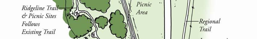
7 The Regional Context Map, below, denotes Daniels Park as a key parcel in over 11,000 acres of open space. It is surrounded on three sides by OSCA, and it is also in close proximity to the Sanctuary Golf Course and Cherokee Ranch. The Daniels Park Area provides great opportunities for regional trail connections. 4
8 The Park Zone Map, below, defines the areas of use in Daniels Park. Land uses generally remain the same for the proposed road & site improvements. Park maintenance remains in the same area. 5
9 Existing Site Photos View North West to Picnic Shelter, Vault Toilet, Parking Lot and Daniels Park Road Intersection at Castle Pines Parkway Existing Parking Areas along Road Problems with Dust and Excessive Speed Poor Sightline Bison Underpass Bison Fence Historic Ranch & Barn 6
10 The Site Analysis Map, below, defines the prominent ridge along which Daniels Park Road is aligned. It also reflects minor ridgelines, valleys and drainage ways. Spectacular views of the mountain range are identified. Problem areas along the road (like limited sight distance and erosion problems) are indicated as well. 7
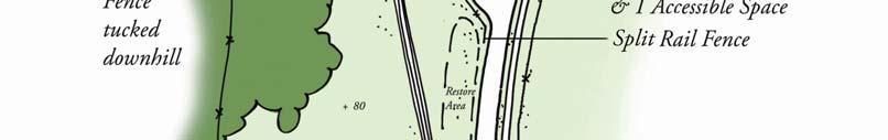
11 Daniels Park Road s current alignment is indicated in white. The conceptual road improvements for Castle Pines Parkway are identified in light orange (at the southern end of the park). Opportunities for trailheads and a regional trail are shown in red. Green stars indicate potential pedestrian crossings and traffic calming points along the road. A chartreuse circle represents the opportunity for a gateway to the park at both ends of the park. 8
12 Daniels Park Road Daniels Park Castle Pines Parkway Sanctuary Golf Course To Route 85 & Castle Rock This drawing represents Douglas County s conceptual plans for improving the intersection of Castle Pines Parkway and Daniels Park Road. The existing angular intersection with steep grades to the south could be replaced with a sweeping loop. The main flow of traffic will follow the loop, leaving only park traffic to turn into Daniels Park. Traffic flow, traffic safety, sight distances, and steep grades are improved with this design. 9
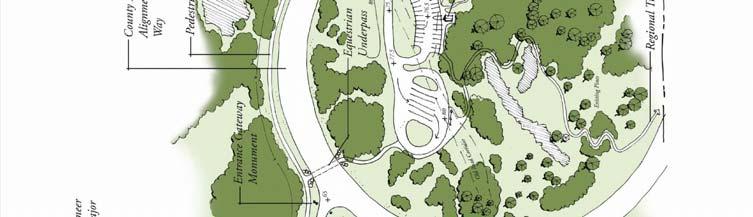
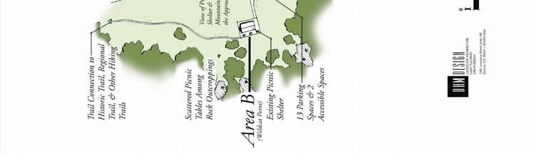
13 Page 16 is a Conceptual Master Plan for Daniels Park. Components of the master plan are described below in more detail. Grigs Road Tall Bull Memorial Grounds Daniels Park Road Park Maintenance Area & Historic Florence Martin Ranch Landmark District Picnic Shelter Castle Pines Parkway Key Map of Daniels Park (Areas of the Park defined by letters A-E) Southern End of the Park and Trailhead, Area A: Interior to the loop created by the realignment of Castle Pines Parkway, and in the existing gravel parking area, a new trailhead could be developed to allow for equestrian and regional trail access. This site could also provide a restroom facility with public utility connection, water faucet, hitching post, and picnic sites for park users, and a Douglas County Sheriff satellite station. Conceptual sketches for the restroom and sheriff station are shown in Figures 1 & 2. These two buildings could also be combined into a single building for cost savings. The abandoned portion of the existing road is designated for the development of this trailhead. An equestrian trail will connect to the south, as well as, to the north and east of Daniels Park Road by a new underpass. Refer to Daniels Park Entry Master plan, Area A, page 17 for more detail. 10

14 Figure 1 Figure 2 11

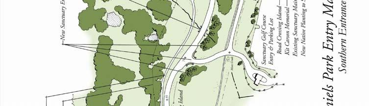
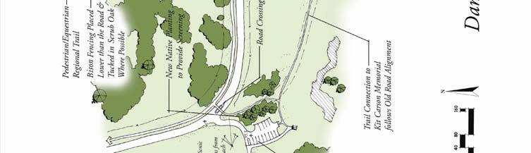
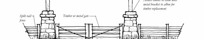
15 The Gateway to Daniels Park: A gateway monument will identify the entrance to Daniels Park (Figures 5-7). An existing rock outcrop could be preserved as a landscape amenity, and it could create an opportunity for a split entrance treatment at the park s southern entrance as shown in Figure 6, page 25. A conceptual sketch of the entry monument is provided in Figure 7, page 25. This type of gateway entry monument can be used at both the northern and southern entrances to define the park. A narrower road section is proposed to help define this road as park-like in character curvilinear to emphasize views and slow vehicular speed. Addition of a natural edge barrier could help define the road edge and prevent pull-offs and road widening. The park road begins with views to the west and then gently follows the contours until reaching the picnic shelter. A new entry road is provided for the Sanctuary Golf Course, allowing for an expanded landscape buffer between the golf course and the park while improving stacking and sight distance to their entrance. A trail connection is made from the picnic shelter to the Kit Carson Memorial that follows the historic road alignment. Open fences (such as split rail) are proposed in some areas to encourage restoration and prevent off road driving. Refer to Daniels Park Entry Master Plan, page 17 for more detail. Picnic Shelter, Area B: View of Entry Experience into Daniels Park This area contains the existing historic picnic shelter, emergency phone, and parking. The parking lot is re-defined and paved in the same general location as the existing lot. With the re-alignment of Daniels Park Road, space is recaptured for visitor enhancements including trails, picnic areas, restroom facilities and open space away from road impacts. Trail connections are provided to the regional trail to the north and to picnic sites and historic trails. Individual picnic sites require revamping, new picnic tables, etc. Refer to Daniels Park Entry Master Plan, Area B, on page 17 for more detail. 12


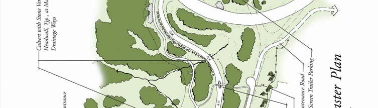
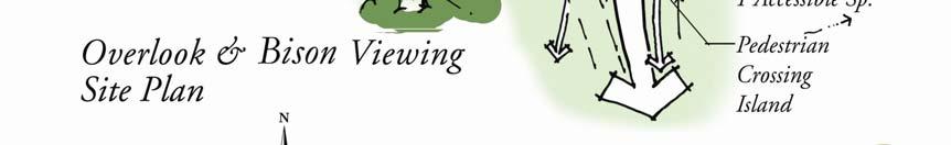
16 Overlook and Bison Viewing, Area C: In this area, Daniels Park Road bows out to the east from its existing alignment following the existing contours. By doing this, there is a greater distance between the road and the park amenities, which include some of the most spectacular mountain viewing areas in the park. The proposed west parking lot is located at an existing gravel parking area and is aligned along the historic road. This parking lot provides access to picnic sites and a portion of the original Territorial Road alignment. The proposed historic trail is narrow, having an old wagon road appearance and would provide interpretive signage describing the history of the original route. It also offers great views to the west and allows visitors to travel leisurely and with families without concern about the vehicular traffic to the east. The regional trail and the equestrian trail are on the east side of the road providing more direct routes to other regional trails. A small parking lot on the east side of the road provides a safe place to stop to view the bison herd. The bison often come to this site for dusting themselves. Refer to Overlook & Bison Viewing Site Plan, Area C, on page 19 for more detail. Figure 3 Single or Double Wagon Trail Option 13


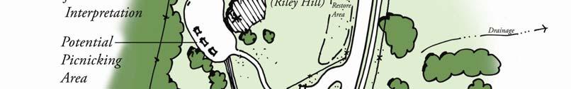
17 Riley Hill Overlook, Area D: Daniels Park road will move slightly off the existing alignment in order to remove sharp curves in the road and solve sightline issues. The crest of the road is lowered in elevation to improve sightline. A small parking lot provides access to the highest overlook point in the park. This 270-degree view affords views onto the mountains, the historic Florence Martin Ranch, the Chatfield Reservoir, and a good portion of Daniels Park. There is an existing rock outcrop and rocky clearing which is a great site for picnicking and interpretation of the historic ranch and views. The historic trail follows an earlier alignment of Daniels Park Road. Where possible, the bison fence is moved to a lower elevation or tucked into vegetation in order to reduce or buffer its visual appearance. Refer to Riley Hill Overlook, Area D, on page 14 for more detail. View of the historic ranch from the Riley Hill Overlook Florence Martin Ranch Entrance: Conceptual sketches of the historic ranch entrance are reflected in Figures 8 & 9, on page 26. The character of the entrance gates should be complimentary to the gateway entrance monuments, but define it as a private ranch entrance, separate from the park. The use of similar stone columns can be used to match the character of the gateway entrance monuments and other features in the park. 14


18 Historic Barn Overlook, Area E: At this location, there is a great opportunity for bison viewing. The existing bison underpass will be improved, Figure 4. Trails with overlook points provide visitors with a good vantage point to seeing the bison pass under the road, as well as, graze in front of the historic barn and silo. Park users currently pull off in this general location but they do not have a safe place to park, especially with the existing curve in the road. Refer to Historic Barn Overlook, Area E, on page 20 for more detail. Figure 4 15
19 EXHIBIT B-1 16

20 EXHIBIT B-2 17


21 EXHIBIT B-3 18


22 EXHIBIT B-4 19
23 EXHIBIT B-5 20
24 21


25 Park Theming: The proposed theme for the entry monuments and site improvements for Daniels Park is developed along the lines of a rustic craftsman style ranch. This theme is derived from the existing historic ranch, as well as, nearby Cherokee Ranch and Palmer Lake in the southern part of the county. The gateway to the park will include entry monuments built from blocky stone similar to the existing 1920 s picnic shelter. Other elements in the Park that shall reflect this theme include the Florence Martin Ranch entrance, the bison and equestrian underpasses, potential retaining walls, restrooms, and a potential sheriff station. Entry Monument at Palmer Lake 22


26 Cherokee Ranch Entrance Gate Existing picnic shelter at Wildcat Point & example of stonework Existing picnic shelter at Wildcat Point in Daniels Park 23
27 Figure 5 EXHIBIT D 24

28 Figure 6 Figure 7 EXHIBIT D 25
29 26

30 Figure 8 Figure 9 27
31 Signage: The proposed park signage will incorporate the ranch style theme and carry over the same stonework, timber posts, and wooden sign panels as the entry monument to Daniels Park and the ranch entrance gate. Figure 10 Figure 11 28
32 Traffic Calming: Traffic calming devices can be a mixture of design elements. First of all, there will be less traffic than exists today due to the proposed road improvement at Castle Pines Parkway at the south end of the park. The road will be designated as a rural type road with low-posted speeds, a narrow road section, and curvilinear configuration. Secondly, pedestrian crossings with refuge islands or stone paved crosswalks will aid in traffic calming, Figure 12. An expanded pavement change each way from the crossing can also provide the driver with a visual cue to heighten caution. The pedestrian crossing locations should be located as a part of the intersection to parking or a significant distance from the intersection to avoid conflicts at the intersection. Figure 12 29


33 Example of a refuge island & change in pavement color for crosswalk Example of sign/vertical element to indicate pedestrian crossing 30
34 31
35 32
BISCUIT RUN PARK MASTER PLAN
 BOARD OF SUPERVISORS November 14, 2018 BISCUIT RUN PARK MASTER PLAN COUNTY OF ALBEMARLE ANHOLD ASSOCIATES Contents Project Introduction Property Background County Park Planning Process Existing Site &
Standards (R-3) Figure B-11: R-3 Residential Standards Exhibit
 Figure B-11: R-3 Residential Standards Exhibit") Avila Ranch Avila Ranch Specific Plan Development Standards High Medium Density - High Residential Density Residential Lot and Building Lot and Standards Building (R-3) Standards (R-3) EXAMPLES These sketches
Avila Ranch Avila Ranch Specific Plan Development Standards High Medium Density - High Residential Density Residential Lot and Building Lot and Standards Building (R-3) Standards (R-3) EXAMPLES These sketches
Preliminary Sketch Plan for Fort Hunter Park
 Preliminary Sketch Plan for Fort Hunter Park Public Presentation November 19, 2009 Dauphin County Parks and Recreation 100 Fort Hunter Road Harrisburg, PA 17110 (717) 599-5188 www.dauphinc.org THOMAS COMITTA
RZC Public View Corridors and Gateways
 RZC 21.42 Public View Corridors and Gateways 21.42.010 Purpose 21.42.020 Scope and Authority 21.42.030 Administration 21.42.040 Gateways Design 21.42.050 Unidentified Public Views 21.42.060 Identification
Division 9 Southwood Ranch (CR 484/475/475A Corridor-Gateway Development Overlay) Purpose and Intent Applicability.
 Purpose and Intent Applicability.") Division 9 Southwood Ranch (CR 484/475/475A Corridor-Gateway Development Overlay) 5.9.1 Purpose and Intent. The Southwood Ranch Overlay is intended to be a mixed use community with commercial and residential
Division 9 Southwood Ranch (CR 484/475/475A Corridor-Gateway Development Overlay) 5.9.1 Purpose and Intent. The Southwood Ranch Overlay is intended to be a mixed use community with commercial and residential
Appendix A COMMUNITY IMPROVEMENT PLAN DESIGN GUIDELINES
 Appendix A COMMUNITY IMPROVEMENT PLAN DESIGN GUIDELINES INTRODUCTION The continuous and desirable improvement of Arnprior requires a clear understanding of what is envisioned for the Town. These Design
Design Guidelines and Development Standards for Southwood Ranch. Prepared February, 2016 by
 Design Guidelines and Development Standards for Southwood Ranch D e s i g n D i s t r i c t Prepared February, 2016 by Table of Contents Introduction 2 District Overlay Map. 3 Development Standards. 4
2.0 AREA PLANS. Lakeside Business District. Lakeside Business District Land Use Categories:
 Lakeside Business District Lakeside Business District Land Use Categories: Campus Commercial Campus Commercial means a mixture of uses which includes corporate offices, office parks, hotels, commercial,
4. INDUSTRIAL 53 CASTLE ROCK DESIGN
 4. INDUSTRIAL 53 CASTLE ROCK DESIGN CASTLE ROCK DESIGN 54 4. INDUSTRIAL Overview Well-designed and attractive industrial centers are the product of blending economic realities with both functional and
SECTION TWO: Urban Design Concepts
 SECTION TWO: Urban Design Concepts The Gardnerville Plan for Prosperity shapes economic opportunities presented by regional growth. The Urban Design Concepts provide policies and concepts for land use,
CHAPTER FIVE COMMUNITY DESIGN
 CHAPTER FIVE COMMUNITY DESIGN CHAPTER FIVE - COMMUNITY DESIGN Assumptions Frazier Park and Lebec have historically developed according to different patterns of spatial form. While both communities are
PROPOSED REDEVELOPMENT OF THE GLEN ABBEY GOLF CLUB. STREETSCAPE DESIGN STUDY (excerpt from the Urban Design Brief) TOWN OF OAKVILLE.
 TOWN OF OAKVILLE.") PROPOSED REDEVELOPMENT OF THE GLEN ABBEY GOLF CLUB STREETSCAPE DESIGN STUDY (excerpt from the Urban Design Brief) TOWN OF OAKVILLE OCTOBER, 2016 for 2.4.2 STREETS Streets are the single largest component
PROPOSED REDEVELOPMENT OF THE GLEN ABBEY GOLF CLUB STREETSCAPE DESIGN STUDY (excerpt from the Urban Design Brief) TOWN OF OAKVILLE OCTOBER, 2016 for 2.4.2 STREETS Streets are the single largest component
3.10 LAND USE SETTING PROJECT SITE EXISTING LAND USE DESIGNATIONS AND ZONING. General Plan Land Use Designations.
 This section of the Draft EIR addresses the existing land uses on and adjacent to the project site and discusses the potential impacts of the proposed project on existing land uses. Key issues addressed
Potential Green Infrastructure Strategies May 6, 2015 Workshop
 Potential Green Infrastructure Strategies May 6, 2015 Workshop Background The City of Cortland is developing the Tioughnioga Urban Headwaters Green Infrastructure Action Plan with funding from the National
2011 ASLA Design Awards. Centennial Park Merit Award Design Concepts CLA, Inc. Design over $500,000 Construction Budget
 2011 ASLA Design Awards Centennial Park Merit Award Design Concepts CLA, Inc. Design over $500,000 Construction Budget 2011 ASLA Colorado Professional Design Awards Project Name: Category: Location: Const.
II. SINGLE FAMILY RESIDENTIAL
 II. SINGLE FAMILY RESIDENTIAL Castle Rock is made up of numerous individually built houses and subdivision tracts that have been developed during the past century. Some of the tracts are diverse in architectural
OPPORTUNITIES AND CONSTRAINTS - OXBOW PARK ENTRANCE AND PUT-IN
 OPPORTUNITIES AT OXBOW EXISTING WETLANDS Site is undeveloped and we can design a park that works well from the start. SAND BEACH Potential to eliminate invasive species. DEBRIS (CONCRETE, OLD CARS) VEGETATION
Status Update (2006 vs. Now) Citizen s Advisory Committee February Plan for Prosperity
 Citizen s Advisory Committee February Plan for Prosperity") Status Update (2006 vs. Now) Citizen s Advisory Committee February 2018 Plan for Prosperity 2000 2017 2000 2017 Gardnerville Population 6,000 5,760 5746 5,500 5,000 5,067 5,550 5,165 5,394 5,412 5,250
Status Update (2006 vs. Now) Citizen s Advisory Committee February 2018 Plan for Prosperity 2000 2017 2000 2017 Gardnerville Population 6,000 5,760 5746 5,500 5,000 5,067 5,550 5,165 5,394 5,412 5,250
Public input has been an important part of the plan development process.
 Lakewood s Comprehensive Plan recognizes that transportation helps shape the community, and that the way the community provides for the safe and efficient movement of people affects the character of the
The Vision. Photo provided by The Minervini Group. 46 Vision, Objectives & Strategies
 Vision, Objectives & Strategies The is the public framework and guide for future development of the Grand Traverse Commons. The establishes public polices for infrastructure, the preservation of natural
Access Management: An Overview
 Figures 1-5 Below Evolution of development along a highway. In the early stages, land along the road is used for farming with little traffic generated. As time passes, the highway corridor becomes a de
PLANNING AND NATURAL RESOURCES COMMITTEE. Public Access Conceptual Design Alternatives for the Red Barn Area of La Honda Creek Open Space Preserve
 PLANNING AND NATURAL RESOURCES COMMITTEE R-17-56 May 9, 2017 AGENDA ITEM AGENDA ITEM 2 Public Access Conceptual Design Alternatives for the Red Barn Area of La Honda Creek Open Space Preserve GENERAL MANAGER
Hidden Pointe Landscape Master Plan. June, archi terra
 Hidden Pointe Landscape Master Plan June, 2006 t h e archi terra g r o u p 1 Table of Contents Background Purpose and Goals of the Master Plan Master Plan Process Existing Conditions Entrance Hidden Pointe
RESIDENTIAL PLANNED UNIT DEVELOPMENT / SUBDIVISION AND REZONING CONCEPT AND DEVELOPMENT STAGE PLAN SUBMITTAL NARRATIVE
 RESIDENTIAL PLANNED UNIT DEVELOPMENT / SUBDIVISION AND REZONING CONCEPT AND DEVELOPMENT STAGE PLAN SUBMITTAL NARRATIVE DEVELOPMENT TEAM DONEGAL SOUTH Maple Grove, Minnesota March 27, 2017 Applicant/Developer/Builder:
Washington Pass Overlook
 Washington Pass Overlook The Washington Pass Overlook is located on the Methow Valley Ranger District on the Okanogan-Wenatchee National Forest. The overlook is at the crest of Washington Pass and is part
Development. Within of 25% or greater. ridges anticipated that the. foundations. and walk out. Page 1 of 4
 Ridge Estates May 11, 2016 LAND SUITABILITY ANALYSIS REPORT 1. INTRODUCTION This report is provided in accordance with the submittal requirements of the Planned Development Plan (PPD). The report accompanies
KCROS East Plum Thicket-Manzanita Social Trail Conversion Plan. Prepared by Jeff Lyslo and Dan Mullins, Volunteer Trail Coordinators March 2017
 KCROS East Plum Thicket-Manzanita Social Trail Conversion Plan Prepared by Jeff Lyslo and Dan Mullins, Volunteer Trail Coordinators March 2017 Overview There are a number of existing social trails between
section five BEAUTIFICATION PLAN
 section five BEAUTIFICATION PLAN BEAUTIFICATION PLAN Section Five Beautification Plan The goal of the Beautification Plan is to improve the Route 8-Sunnyland Corridor in terms of aesthetics and to create
Mississauga Waterfront. Parks Strategy - Draft
 Potential configuration for river s edge seating. Boating on Credit River: A regatta Boating on Credit River: Active enjoyment 5.2 Port Credit Memorial Park West Priority Park 5.2.1 Site Opportunities
Woods Chapel Park. Park Amenities: Playground, basketball court, single table shelter, small pond and multi-use trail.
 Woods Chapel Park Park Location: 3925 NW Dogwood Park Land Established: 1979 Park Size: 10 acres Developed Acres: 6 acres Undeveloped Acres: 4 acres Park Type: Neighborhood Park Amenities: Playground,
Eligible, see Statement of Significance. Roadside Development on Minnesota Trunk Highways,
 Historic Name CS # 0115 Other Name SHPO Inv # Location Both sides of TH 169 on isthmus between Little Pine Lake and Hickory Lake Hwy District Reference City/Township County Farm Island Township Aitkin
Development. Within of 25% or greater. ridges anticipated that the. foundations. and walk out. Page 1 of 4
 Ridge Estates May 11, 2016 LAND SUITABILITY ANALYSIS REPORT 1. INTRODUCTION This report is provided in accordance with the submittal requirements of the Planned Development Plan (PPD). The report accompanies
Chapter 4: Jordan Road Character District
 4: Jordan Road Character District 4.1 Introduction The Jordan Road character district encompasses much of the former Jordan orchard and farmstead, which was a significant part of Sedona s history. The
CITY PLANNING COMMISSION AGENDA. ITEM NO(s): C.1 C.3 STAFF: STEVE TUCK
: C.1 C.3 STAFF: STEVE TUCK") Page 34 CITY PLANNING COMMISSION AGENDA ITEM NO(s): C.1 C.3 STAFF: STEVE TUCK FILE NOS: CPC ZC 12-00035 QUASI-JUDICIAL CPC NV 12-00036 QUASI-JUDICIAL AR DP 12-00039 QUASI-JUDICIAL PROJECT: APPLICANT: OWNER:
Page 34 CITY PLANNING COMMISSION AGENDA ITEM NO(s): C.1 C.3 STAFF: STEVE TUCK FILE NOS: CPC ZC 12-00035 QUASI-JUDICIAL CPC NV 12-00036 QUASI-JUDICIAL AR DP 12-00039 QUASI-JUDICIAL PROJECT: APPLICANT: OWNER:
VEHICULAR AND PEDESTRIAN CIRCULATION
 This perspective sketch communicates the intended character and quality of a proposed streetscape design. Locate benches near a major intersection where people tend to gather. Seating and lighting provide
APPENDIX C. Architectural and Environmental Design Standards. Environmentally sensitive areas should be protected.
 APPENDIX C Architectural and Environmental Design Standards Environmentally Sensitive Areas Goal A. Environmentally sensitive areas should be protected. Development, such as roads, houses, and other structures,
ACADEMY AREA CONCEPT PLAN
 ACADEMY AREA Strip ling C hape l Roa d CONCEPT PLAN 7 S2 U Stripling 52 ROADWAYS AND PARKING: ADVENTURE PLAYGROUND AND SPRAYGROUND: Current roadways follow existing drives. It is recommended that the Folds
V. Gateways GATEWAYS / V-1
 V. GATEWAYS / V-1 Many of Chesapeake s gateways are located on highways and call for bold and attractive designs that motorists can understand, appreciate, and enjoy. can also take the form of natural
Small Area Plan. South Gateway
 Small Area Plan Adopted May 12, 2008 South Gateway Purpose. The South Gateway Small Area Plan defines the City s expectations for the future of the southern entrance to the City at Interstate 85 and Highway
ILLUSTRATIVE MASTERPLAN
 ILLUSTRATIVE MASTERPLAN The Development Dairy Crest (Imperial College) The Proposed Development aims to create a new high quality residential neighbourhood, alongside a new public park for White City.
Design Considerations
 Essential to the development of a successful Master Plan for the Park Complex is input from the community that the park will serve. The community outreach component of the planning process included numerous
Maplewood Avenue Downtown Complete Street Project
 Maplewood Avenue Downtown Complete Street Project Second Public Meeting January 24, 2018 Welcome and Introduction of Project Team City Planning and Public Works Staff City of Portsmouth Juliet Walker Planning
MOUNT ROSE AND WASHOE VALLEY SCENIC BYWAY CORRIDOR MANAGEMENT PLANS
 MOUNT ROSE AND WASHOE VALLEY SCENIC BYWAY CORRIDOR MANAGEMENT PLANS PARK COMMISSION JANUARY 5, 2016 PREPARED BY Aspen Asheville Austin Chicago Denver Dubai Houston Lake Tahoe Los Angeles CORRIDOR MANAGEMENT
Play areas overlooking climbing hill. School & playgrounds overlooking pond bottom ballfields. Project experience while at Loris and Associates, Inc.
 City of Thornton Parks & Open Space Cherrywood Park Thornton, CO Architect: Design Concepts Construction of this seven-acre City park, located adjacent to Adams Twelve Five Star Prairie Hills Elementary
ROAD AND CAR PARK DESIGN GUIDELINES
 3.2 ROAD AND CAR PARK DESIGN GUIDELINES PIHA AREA DESIGN GUIDELINES AUCKLAND REGIONAL COUNCIL 37 Existing Road and Car Park Photos: North Piha carpark Anawhata carpark Winstone Track carpark off Piha Road
Chapter 5: Natural Resources and Environment
 NATURAL RESOURCES AND ENVIRONMENT 5-1 5 Chapter 5: Natural Resources and Environment BACKGROUND AND INTENT Urban expansion represents the greatest risk for the future degradation of existing natural areas,
GUIDELINES EXHIBITION PLACE LOCATION: OBJECTIVES. Structure Plan URBAN DESIGN GUIDELINES
 Development in the Exhibition Place lands will be consistent with the following urban design guidelines. They provide a framework for new development of the lands and are to be read in conjunction with
Town of Portola Valley General Plan. Nathhorst Triangle Area Plan
 Town of Portola Valley General Plan Amended December 10, 1997 Table of Contents Introduction... 1 Planning Area... 1 Objectives... 2 Principles... 2 Standards... 4 Description... 4 Community Commercial...
2011 ASLA Design Awards. Coyote Gulch Honor Award and Land Stewardship Designation Valerian LLC. Environmental Restoration and Reclamation
 2011 ASLA Design Awards Honor Award and Land Stewardship Designation Valerian LLC Environmental Restoration and Reclamation Project Name: Category : Project Location: 5 2011 Environmental Restoration and
5.0 P A R K R E C O M M E N D A T I O N S
 5.0 P A R K R E C O M M E N D A T I O N S 5.1 Confederation Park The analysis of Confederation Park recognizes that it, along with City Hall, is the symbolic heart of Kingston. While the existing layout
Village of Pemberton DOWNTOWN ENHANCEMENT INITIATIVE FRONTIER STREET PILOT PROJECT WE NEED YOUR HELP TO REVIEW THE PLAN
 Village of Pemberton DOWNTOWN ENHANCEMENT INITIATIVE FRONTIER STREET PILOT PROJECT WELCOME TO THE NEW FRONTIER STREET! WE NEED YOUR HELP TO REVIEW THE PLAN The Village of Pemberton would like your feedback
The open space system should provide connective elements, relate to natural resources, and enhance the suburban character of the landscape..
 The open space system should provide connective elements, relate to natural resources, and enhance the suburban character of the landscape.. Mixed-use and infill development should maintain or enhance
North Oakville East Parks Facilities Distribution Plan. November, 2009
 North Oakville East November, 2009 POLICY CONTEXT 1) Purpose a) The purpose of this document is to be a guide for the location, configuration, design and development of the parks system for the North Oakville
Rotary Park / Railroad Lake
 Rotary Park / Railroad Lake Park Location: 600 NW Vesper St. Park Land Established: 1975 Park Size: 12 acres Developed Acres: 12 acres Undeveloped Acres: 0 acres Park Type: Community Park Amenities: 2
3.0 Area-Wide Strategies 30
 3.0 Area-Wide Strategies 30 3.6 Tourism Strategy This section of the plan aims to develop and improve the tourism potential of the area. Strategic Context The City Plan outlines the potential of Cork to
Devil s Slide Coastal Trail Improvements Project. County of San Mateo
 County of San Mateo Project History Measure T Nov.1996 Plans and Permits Task Force meetings Hired a team Board support Budget Project Overview Programming and Linkages Park hours Multi use trail Pedestrians
Girdwood Cemetery Girdwood, Alaska
 Miners Pond Shelter Council Circle Woodl Trails Overlooks Committal Shelter Courts Woodl Burial Bridge to Beaver Pond Trail Protected Stream Valleys Columbarium Court Shelter Woodl Trails Woodl Cremation
FORT MISSOULA REGIONAL PARK
 FORT MISSOULA REGIONAL PARK Master Plan Refinement/ Design Development www.missoulaparks.org DHM Design/WGM Group December 3, 2008 Master Plan Report Fort Missoula Regional Park Guiding Principals i 6/14/01
master plan hodge park
 KCMO Parks & Commissioners Recreation Board of Parks & Recreation Kansas City, Missouri Mark McHenry Director Heather Runkel Project Manager LAND3 Studio L.L.C. Bob G Bushyhead Principle Michael H Malyn
Charles P. Johnson and Associates. Annapolis Landscape Architects
 Charles P. Johnson and Associates Annapolis Landscape Architects AGENDA Introduction Project Limits and Scope Site Analysis Opportunities & Constraints Program Goals Image Boards Design Alternatives Pros
Century Park to Ellerslie Road Preliminary Engineering
 Century Park to Ellerslie Road Preliminary Engineering South LRT Extension Stakeholder Information Panel Brochure March 2010 www.edmonton.ca/lrtprojects LRT Station (left) and Transit Centre Architectural
MASTER PLAN. 201 Planning Concepts. Chapter 2
 Chapter 2 MASTER PLAN 201 Planning Concepts 202 Master Land Use Plan 203 Affordable Housing Program 204 Parks, Open Space, and Recreation Trails 205 Grading Concept 206 Circulation Plan 207 Landscape Concept
ADOPTED CAPITAL IMPROVEMENT PROGRAM BUDGET ARROYO PROJECTS
 ADOPTED CAPITAL IMPROVEMENT PROGRAM BUDGET ARROYO PROJECTS HAHAMONGNA FY 212-216 Capital Improvement Program Priority Description Total Estimated Costs Appropriated Through FY 211 Adopted FY 212 FY 213
DRAFT ALDER CREEK FARM MASTER PLAN
 DRAFT ALDER CREEK FARM MASTER PLAN Lower Nehalem Community Trust Mission: To preserve land and nurture conservation values in partnership with an engaged community in the Nehalem region of the Oregon Coast
FY Capital Improvement Program Arroyo Projects
 FY 219-223 Capital Improvement Program FY 218 FY 219 FY 22 FY 221 FY 222 FY 223 1 2 3 4 5 6 7 8 9 1 Hahamongna - Implement Master Plan - Oak Grove Area Improvements (7756) Hahamongna - Implement Master
DATE: May 25, Watershed Conservation Authority Governing Board. Johnathan Perisho, Project Manager. Mark Stanley, Executive Officer
 DATE: May 25, 2017 TO: FROM: THROUGH: SUBJECT: Watershed Conservation Authority Governing Board Johnathan Perisho, Project Manager Mark Stanley, Executive Officer : Consideration of a resolution to approve
East Harptree Landscape & Character Assessment
 East Harptree Landscape & Character Assessment Produced by East Harptree Parish Council in consultation with local residents September 2014 Contents The Parish of East Harptree: Objective Introduction
Draft Stillwater 2030 Comprehensive Plan- Goals and Policies
 Draft Stillwater 2030 Comprehensive Plan- Goals and Policies Instructions- Review each goal and policy and discuss with group any changes, deletions for additions to the list using your groups pen. Keep
Special Use Permit WSUP
 Special Use Permit WSUP17-0014 Washoe County Board of Adjustment October 4, 2017 GAIL WILLEY 1 Vicinity Map Pleasant Valley 134 Andrew Lane Immediately south of Hwy 395 General Rural 35.9-acres 2 Overview
The Capital Design Advisory Committee St. Mary s College of Maryland & Historic St. Mary s City
 The Capital Design Advisory Committee St. Mary s College of Maryland & Historic St. Mary s City Welcome April 21, 2010 Capital Design Advisory Presentation: Relocating Margaret Brent Hall Traffic Calming
BRADENTON RIVERWALK EXPANSION MASTER PLAN
 BRADENTON RIVERWALK EXPANSION MASTER PLAN INTRODUCTION & AGENDA Process Update Community Engagement Summary Center for Active Design (CfAD) Recommendations Context and Existing Conditions Master Plan Alternatives
Asbury Chapel Subdivision Sketch Plan
 Asbury Chapel Subdivision Sketch Plan PART 1: PROJECT SUMMARY Applicant: NVR Inc. Project Size: +/- 76.13 acres Parcel Numbers: 02101112,02116101,02116112, 02116113 Current Zoning: Transitional Residential
COMMUNITY DESIGN. GOAL: Create livable and attractive communities. Intent
 COMMUNITY DESIGN Intent An attractive, well-designed County will attract quality development, instill civic pride, improve the visual character of the community, and create a strong, positive image for
12 Foot Davis and Adjacent Sites
 Peace River, Alberta Proposed Concept Design Presentation and Discussion January 26, 2010 Peace River Provincial Recreation Area 12 Foot Davis Grave Site Dr. Greene Cairn North Environments Landscape Architects
The Anaheim Resort Public Realm Landscape Program. City of Anaheim. Adopted September 1994 (94R-239)
") Public Realm Landscape Program City of Anaheim Adopted September 1994 (94R-239) Amendment No. 1 October 1996 (96R-178) Amendment No. 2 June 1999 (99R-137) Amendment No. 3 February 2001 (2002R-56) Amendment
Public Realm Landscape Program City of Anaheim Adopted September 1994 (94R-239) Amendment No. 1 October 1996 (96R-178) Amendment No. 2 June 1999 (99R-137) Amendment No. 3 February 2001 (2002R-56) Amendment
WARM SPRINGS PARK MASTER PLAN
 TABLE OF CONTENTS page 1.0 Introduction and Overview 1 2.0 Information Gathering 2 3.0 Conceptual Alternative Development 8 4.0 Master Plan Development 14 5.0 Construction Cost Estimates 19 LIST OF FIGURES
ORDINANCE NO
 ORDINANCE NO. 2013-28 AN ORDINANCE AMENDING CHAPTER 98, ZONING, ARTICLE IV, OVERLAY DISTRICTS AND SPECIAL DISTRICTS OF THE CODE OF ORDINANCES OF WEST MELBOURNE, FLORIDA TO ESTABLISH DIVISION 5, MIXED USE
Project Consulting Team:
 THE DOWNTOWN CHERRYVILLE LAND USE + STREETSCAPE MASTER PLAN WAS FUNDED THROUGH THE GENEROUS DONATIONS OF THE FOLLOWING: The Community Foundation of Gaston County ElectriCities of North Carolina The Cherryville
Minto-Brown Island. November 18, City of Salem, Parks & Transportation Services
 Minto-Brown Island Park Master Plan Public Meeting #1 November 18, 2014 City of Salem, Parks & Transportation Services Division, i i Public Works Welcome... and thanks for participating in the master planning
Gas Stations ottawa.ca
 Urban Design Guidelines for Gas Stations ottawa.ca Ce document est disponible en français sur ottawa.ca. This document is available in French on ottawa.ca. Approved by City Council May 24, 2006 City of
8.0 Design and Form of Development 43/
 42/ 8.0 Design and Form of Development 43/ Rothwells Farm, Golborne/ Development Statement Figure 7. Site Constraints Key 44/ Site Boundary 360 Bus Route/Stops Existing Trees Underground Water Pipe Sensitive
Draft Memorandum #1: Goals and Vision for Revitalization
 Keizer Revitalization Plan Draft Memorandum #1: Goals and Vision for Revitalization Submitted to: City of Keizer April 12, 2018 (revised) Prepared By: Angelo Planning Group and Otak, Inc. Project No. 17482.A
Industrial Development Permit Area
 Industrial Development Permit Area PURPOSE The purpose of this Development Permit Area (DPA) is to establish objectives and provide guidelines for the form and character of industrial development in the
AESTHETIC APPEARANCE. Design Guidelines for Grade-Separated Pedestrian, Cyclist and Equestrian Structures
 III. AESTHETIC APPEARANCE The aesthetic qualities of a grade-separated structure are as important as the specific design criteria. For example, a structure may be constructed to the exact criteria set
1. Parks & Recreation Neighborhood Parks Community Parks Special Use Sites 2. Open Space 3. Trails
 Appendix A: Park Classifications The intent of parks and recreation classifications is to aid in making acquisition and design decisions for park sites, facilities and the organization of recreation space
6.8 SCENIC HIGHWAYS Introduction
 6.8 SCENIC HIGHWAYS 6.8.1 Introduction The Scenic Highways Element is an optional General Plan element authorized by Section 65303 of the Government Code. The Scenic Highways Element is intended to establish
Goals & Objectives (best derived from an input
 Goals & Objectives (best derived from an input process) Goal - sets an intent of the project States the expected result or outcome of the project The trail will provide recreation and transportation opportunities
Policy & Procedure Effective Date: Parks Department Page of
 City of Arvada Policy & Procedure Effective Date: Parks Department Page of TITLE: City of Arvada Prairie Dog Habitat Plan APPROVAL: PURPOSE: To establish a plan for the preservation of black-tailed prairie
Town of Windham. Planning Department 8 School Road Windham, ME voice fax
 Town of Windham Planning Department 8 School Road Windham, ME 04062 voice 207.864-5960 fax 207.892.1916 MEMO DATE: TO: Staff Review Committee FROM: Amanda Lessard, Planner Cc: Ellen Rathbone, St. Germain
5. Father Hennepin Blufs Park and Hennepin Island Father Hennepin Bluffs Park Supporting Initiatives (see Figure 36): 7-22
: 7-22") 5. Father Hennepin Blufs Park and Hennepin Island As described in existing conditions portion of Chapter 2, Father Hennepin Blufs Park lies on the upland portion of the park and Hennepin Island spans the
5. Father Hennepin Blufs Park and Hennepin Island As described in existing conditions portion of Chapter 2, Father Hennepin Blufs Park lies on the upland portion of the park and Hennepin Island spans the
Ward Park. Park Land Established: Developed Acres: 9 acres Undeveloped Acres: 4 acres
 Ward Park Park Location: 1000 SW 22 nd St Park Land Established: 1979-80 Park Size: 13 acres Developed Acres: 9 acres Undeveloped Acres: 4 acres Park Type: Neighborhood Park Amenities: 2 Shelters, tennis
4.1 AESTHETICS AND VISUAL QUALITY
 SCOPE AND METHODOLOGY 4.1 AESTHETICS AND VISUAL QUALITY This section evaluates the potential impacts to aesthetics and visual quality. Aesthetics refers to visual resources and the quality of what can
3.1 Aesthetics, Light, and Glare
 3.1 3.1.1 Introduction This section describes the existing aesthetics, light, and glare setting and potential effects from project implementation on visual resources and the site and its surroundings.
Appendix D North Road/N. Leroy Street Subarea Plan
 North Road/N. Leroy Street Subarea Plan INTRODUCTION The City of Fenton Master Plan was updated in 1996 and included a subarea plan for the North Leroy Street area of the City. It was recognized at that
COMPLETE GREEN STREET CHECKLIST
 COMPLETE GREEN STREET CHECKLIST This document was developed to dissect the structure of an urban street and explore opportunities to make our streets more complete while also integrating green street strategies.
vision & process willowburn, tarves community engagement 04/18
 vision & process Historic Conservation area Scotia intend to create a high quality residential development based upon best practice urban design principles. This will include a contemporary reinterpretation
Corridor Identity. Section 9. Introduction. Corridor Guiding Principles
 Corridor Identity An attractive and healthy community is a critical element of a quality place, and the design of quality places is a balance between environmental, economic, and social considerations.
Working together to leverage limited Funds
 Working together to leverage limited Funds ARAPAHOE COUNTY OPEN SPACES 10 County Budget Conference September 20, 2013 The Power of Partnerships 2013 SORP Conference 5/23/2014 Why Talk About Open Space?
RESPONSES TO PUBLIC CONCERNS AND QUESTIONS
 RESPONSES TO PUBLIC CONCERNS AND QUESTIONS Stations and Summary Questions for Public Meeting #2 June 23, 2015 General Questions / Concerns: 1. Is there any way this development can raise revenue for the
Planning Commission Staff Report June 5, 2008
 Owner/Applicant Taylor Village Sacramento Investments Partners, LP c/o Kim Whitney 1792 Tribute Road #270 Sacramento, CA 95815 Staff Recommendation Planning Commission Staff Report Project: File: Request: