C ity of Grande Prairie Development Services Department
|
|
|
- Gwendoline O’Connor’
- 5 years ago
- Views:
Transcription

1 C ity of Grande Prairie Development Services Department FAIRWAY DEVELOPMENT OUTLINE PLAN OP Approved April 6, 2009 Prepared by: Focus Corporation
2 Table of Contents 1.0. Introduction Plan Area & Context Ownership & Disposition Plan Framework & Policy Context Site Conditions Development Plan Plan Objectives Development Concept Residential Commercial Municipal Reserve Transportation & Servicing Transportation Water Distribution Sanitary Sewer Stormwater Management Shallow Utilities Noise Attenuation Geotechnical Conditions Implementation Proposed Zoning Maps Map 1 Map 2 Map 3 Map 4 Map 5 Map 6 Map 7 Map 8 Plan Area Location Topography Land Use Transportation Water System Sanitary Sewer Storm Drainage Proposed Zoning
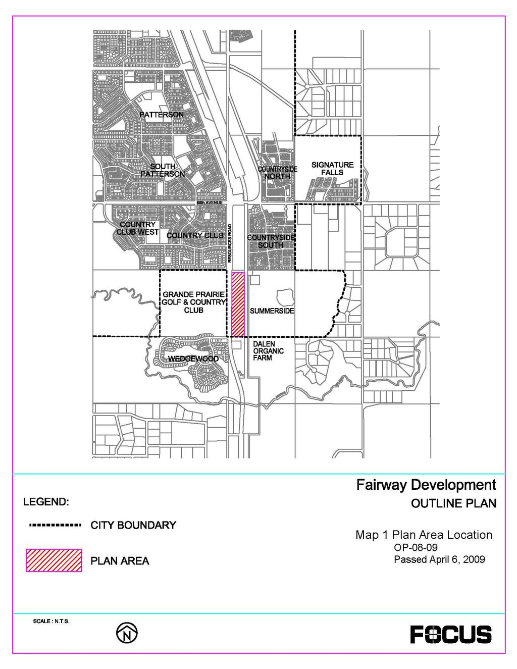
3 Fairway Development Outline Plan 1.0. INTRODUCTION This Outline Plan has been prepared by Focus Corporation on behalf of Alberta Limited. The purpose of this plan is to provide a non statutory framework for the development of land on part of SW W6M in a manner that is attractive and economical, and is compatible and complementary to existing development in the south east area of the City of Grande Prairie. This Outline Plan has been prepared in accordance with Policy of the City of Grande Prairie Municipal Development Plan and clearly identifies and addresses the following criteria: 1.1. Plan Area & Context Physical features and development constraints; Future land uses; Best opportunities for access and egress; Disposition of Municipal Reserve; and Proposed servicing for the site. This Outline Plan applies to approximately (29.05 acres) hectares of land located in the south east of the City of Grande Prairie. The Plan Area is bounded by Resources Road on the west and by the Canadian National Railways line to the east. The lands to the west, across Resources Road belong to the Grande Prairie Golf and Country Club. The lands to the north are the proposed Kennedy Developments Outline Plan area, and the lands directly to the east are within the Summerside Outline Plan area. The lands to the south are currently occupied by the Dalen Organic Farm within the County of Grande Prairie. Refer to Map 1 Plan Area location. The City of Grande Prairie Page 2
4 Fairway Development Outline Plan 1.2. Ownership & Disposition The Plan area is legally described as Railway Right of Way Plan 5814NY within Meridian 6, Range 5, Township 71, southwest quarter of Section 7, comprising forty six and twenty five hundredths Acres (46.25) more or less. A title search conducted December 4, 2007 shows the owners are Alberta Ltd with no instruments. Exceptions to the parcel include the following: Table One Exceptions Plan Description Hectares (Acres) Plan 4863TR Road 3.26 (8.06) Plan Railway (8.00) Plan Road (1.14) Once all exceptions are considered, the Plan incorporates approximately ha (29.05 acres) of land Plan Framework & Policy Context This proposed Outline Plan has been prepared in accordance with the requirements of the Grande Prairie Municipal Development Plan (MDP) and the Southeast Area Structure Plan. In particular it encourages and facilitates appropriate growth, as well as meeting the requirement for new commercial and residential development to be developed in an orderly and continuous manner. The lands are currently districted as Urban Reserve under the City of Grande Prairie Land Use Bylaw C Re districting to the appropriate City of Grande Prairie land use districts will be undertaken to allow for development Site Conditions The Plan area is currently vacant land with some trees located in the north end and along the eastern boundary. The City of Grande Prairie Page 3
5 Fairway Development Outline Plan As illustrated in Map 2 Topography, existing storm drainage for the area follows the contours from west to east DEVELOPMENT PLAN 2.1. Plan Objectives The objectives for this Outline Plan are as follows: General Objectives: To develop a community that is consistent and compatible with itself and with development on adjacent lands; To provide services to standards of the City of Grande Prairie and Aquatera Utilities; To allow for economical phased development at the earliest practical date consistent with City policies; To provide a development that is unique, attractive with high standards for appearance and design and serves as a gateway to the southeast portions of the city; To provide opportunities for affordable housing; and To develop a whole community where residents have opportunities to live, work, and play; To ensure that the commercial development is highly visible with ease of access and egress; To meet the needs of future residents for parks, both passive and active; To recognize the open space opportunity of the storm water management facility; To develop park and open space in accordance with the provisions of the City of Grande Prairie s Parks Maser Plan; and To fulfill the statutory requirements of the Municipal Government Act by providing up to 10% of the area for open space in the form of neighbourhood parks, schools and parkways for storm water conveyance and management. The City of Grande Prairie Page 4
6 Fairway Development Outline Plan 2.2. Development Concept The proposed land use concept for the Plan area is illustrated in Map 3, and a summary of land uses is provided in Table 2 Land Use Summary. predominant land use will be medium density multi family residential with a quarter of the Plan area in the southern portion dedicated to commercial development. Table Two Land Use Summary The Land Use Category Total (ha) % of NDA Net Developable Area (NDA) Multi Family, Medium Density Residential (RM) Commercial (CS) Stormwater Management Facility Municipal Reserve Road As indicated in Table 2, the Net Developable Area is hectares Residential It is envisioned that the Plan area will be developed primarily as medium density residential with approximately 5.32 ha or 45% of the Net Developable Area dedicated to multi family residential units. Assuming 1.6 persons per unit and 74 units per hectare, the estimated population for this development will be approximately 630 individuals, of which approximately 130 will be school aged. (Please see Tables 3 and 4.) The City of Grande Prairie Page 5
7 Area (h a) Density (Units/ha) Fairway Development Outline Plan Table Three Outline Plan Population Estimates Total Un its Population Density/Unit Total Population Population Density/ha Table Four Student Generation Total Population 630 Total Students 130 Public School Students 81 Grades K 9 58 Grades Catholic School Students 49 Grades K 9 39 Grades Total K 9 97 Total Total Students 1 : Public School Students: Catholic School Students: Public K 9 Students: Catholic K 9 Students: 20.06% of Total Population 62.3% of Total Students 37.7% of Total Students 72% of Total Public Students 79% of Total Catholic Student 2.4. Commercial A 2.33 ha commercial site has been identified for the south portion of the Plan area. It is envisioned that this area will be developed primarily as a commercial service district Municipal Reserve In accordance with the Municipal Government Act, the Plan provides for the provision of Municipal Reserve in the form of a neighbourhood park adjacent to and surrounding the stormwater management facility in the north end of the subject 1 Based on September 2007 school enrolments, assuming City population estimate of 50,227. The City of Grande Prairie Page 6
8 Fairway Development Outline Plan lands comprising approximately 1.18 ha of land (10% of the Net Developable Area). The park design meets the requirement of 20% continuous frontage on a local road. The design of the park area will be dealt with in the Park Design Report TRANSPORTATION & SERVICING 3.1. Transportation The Plan area is served by Resources Road along the western boundary. According to the City s Transportation Master Plan, Resources Road will be upgraded to a fourlane divided standard to Wedgewood Drive. As illustrated in Map 4 Transportation, main access to the site shall be through the development of all directional intersections at the halfway point between the north and southern boundaries, and at Wedgewood Road on the southern boundary of the subject lands. The existing roadway along the northern boundary currently provides access into a private residence in the north west corner of the Summerside Outline Plan area. This existing roadway is to be closed once the private residence is provided with an alternative access. Internal access to the Plan area will be provided by a public local road running north to south within the Plan area along the eastern boundary adjacent to the rail line. Additional detailed information pertaining to transportation is outlined in the Traffic Impact Assessment Water Distribution There are two existing watermains adjacent to the Plan area: a 200mm watermain on the west side of Resources Road, which extends from Wedgewood to Country Club, and a 200mm watermain located 250 meters north of the Plan area within Utility Right of Way Plan Internal distribution will be provided through a 250mm main connected to the existing mains. Final alignment will be dependant upon development, but will be located within right of ways or servicing easements. A potential interim connection may be made on the east side of the railroad tracks to the existing 200mm watermain within PUL 45. The proposed looped water The City of Grande Prairie Page 7
9 Fairway Development Outline Plan system for the Plan area is illustrated on Map 5 Water Distribution. Additional detailed information pertaining to water distribution/fire system is outlined in the design report for water Sanitary Sewer As illustrated in Map 6 Sanitary Sewer Servicing, the 88 Street Trunk Main (900mm) exists along the north boundary of the public road right of way, north of the Plan area. An existing sewer main (200mm) also exists on the south side of the Wedgewood access at Resources Road. A proposed 250mm diameter gravity sanitary sewer main will tie into both existing trunk mains and be extended along the west side of the Plan area. Additional detailed information pertaining to the sanitary system is outlined in the design report for sanitary Stormwater Management The Plan area consists of a total drainage basin of approximately 18.9 ha in size. The Plan area is split into three stormwater management sub basins, each managing stormwater in a different manner. The proposed wet pond at the north end of the Plan area has a basin area of approximately 16.6 ha. As illustrated in Map 7 Storm Drainage, stormwater will be collected by a combination of storm sewer mains and overland drainage and directed to a stormwater pond in the north end of the development. During extreme rainfall events the pond will overflow and be directed east across the railroad tracks along existing overland drainage routes as shown in Map 7. Stormwater will be detained in the storm pond and released at pre development flows to a proposed piped trunk which will be directed east to the existing Summerside pond. The Kennedy Development wet pond immediately to the north of the Plan area will be connected to Fairway proposed wet pond via underground pipe. These two ponds will function as one. The City of Grande Prairie Page 8
10 Fairway Development Outline Plan Approximately 1.5 ha of commercial lands at the southern end of the commercial area will be provided with onsite stormwater detention. Minor flows from this area will be directed to the wet pond at the north end of the Plan area. The existing topography of the lands does not allow overland drainage to be directed to the wet pond. It is intended that runoff between the 5 year and 100 year rainfall events be detained onsite. A variety of methods may be used to provide onsite stormwater management which is commonly done by creating shallow ponds within parking lots. The release rate from the commercial development will be the 5 year post development flow used to size the proposed storm sewer mains to the proposed wet storm pond. Ultimately, runoff for events greater than a 100 year event will be directed overland east to the Summerside overland drainage routes. At the southeast corner of the Plan area, approximately 0.8 ha of the lands cannot be provided with a stormwater management system to manage runoff for events greater than the 5 year. This area comprises of the proposed road right of way and existing CNR right of way. The proposed storm sewer system will direct events up to the 5 year rainfall event to the wet storm pond. Runoff for events greater than the 5 year will be directed overland to the Summerside overland drainage routes. Ortho imagery and local knowledge indicated the presence of wetlands. In accordance with the Alberta s Water Act and Alberta Environment s Provincial Wetland Restoration/Compensation Guide, a qualified aquatic environmental specialist was employed to conduct a wetland assessment for the subject lands. The conclusions from this assessment identified two wetland areas comprising 1.42 ha with limited wildlife and ecological value already heavily impacted by surrounding development activities. It is the recommendation of the assessment report that these wetlands be removed and compensated for. The wetland assessment report will be submitted concurrently with this Outline Plan to Alberta Environment. Approval for development and compensation will be dealt with prior to construction. The City of Grande Prairie Page 9
11 Fairway Development Outline Plan The study area is in an area of a high water table. A geotechnical report written by J.R. Paine & Associates, February 2008, refers to this and makes recommendations for design and construction of buildings, roads, underground utilities, fills and stormwater management facility. The existing drainage course crosses the railroad tracks at a 750mm diameter culvert approximately 250m south of the north property boundary and at a 1200mm diameter culvert approximately 70m north of the south property boundary and flows to the existing Summerside pond. The ultimate drainage design for the Plan area will not use either of these existing culverts. The proposed culvert crossing of the CNR tracks and grading within CNR lands will require CNR approval at the detailed design stage. Additional detailed information pertaining to the storm sewer system is outlined in the design report for stormwater 3.5. Shallow Utilities All shallow utilities (natural gas, power, telephone, and cable) are to be extended into the Plan area by the individual franchise holders as required Noise Attenuation Noise attenuation of Resources Road adjacent to the proposed residential areas will be attained through the construction of a 4.3 meter high noise attenuation structure from the Plan area finish grade. A 2.5 meter berm and 6 foot fence could be constructed to achieve this requirement. Alternative unique noise attenuation barriers can be considered to minimize Plan area sterilization. Some considerations can be the use of, or the combination of, trees, retaining walls, earth reinforced walls, fence, earth berm, and/or any other acceptable noise attenuation methods. Noise attenuation will not be required for commercial, park, or stormwater management facility land uses adjacent to Resources Road. The City of Grande Prairie Page 10
12 Fairway Development Outline Plan 3.7. Geotechnical Conditions The following report has been written and submitted to the City of Grande Prairie: Geotechnical Investigation, Multifamily & Commercial Subdivision, RLY 71, Plan 5814NY, Pt. of SW , Grande Prairie, Alberta JR Paine & Associates Limited, February The study area is in an area of a high water table. The geotechnical conditions encountered throughout the study area are dominated by silt based soil deposits. The above referenced geotechnical report refers to this and makes recommendations for design and construction of buildings, roads, underground utilities, fills and stormwater management facility IMPLEMENTATION 4.1. Proposed Zoning As illustrated in Map 8 Zoning, the multi family residential portion of the Plan will be zoned under the RM Medium Density Residential District and the commercial area will be zoned under the CS Commercial Services District of the City of Grande Prairie Land Use Bylaw C It is intended that site zoning be made concurrently with the Outline Plan approval. The City of Grande Prairie Page 11
13
14
15
16
17
18
19
20
City of Grande Prairie Development Services Department KENNEDY DEVELOPMENTS LTD. OUTLINE PLAN OP-09-01
 City of Grande Prairie Development Services Department KENNEDY DEVELOPMENTS LTD. OUTLINE PLAN OP-09-01 July 27, 2009 TABLE OF CONTENTS 1.0 Introduction... 1 1.1 Plan Area Location & Context... 1 1.2 Ownership
OP Council Resolution June 16, Planning and Development Services
 OP-08-01 Council Resolution June 16, 2008 Planning and Development Services Kingsgate Landing Outline Plan Table of Contents 1.0 Introduction 1 1.1 Purpose of Plan 1 1.2 Plan Area Location 1 1.3 Ownership
Bylaw C-1262 Adopted February 6, Planning and Development Department
 Bylaw C-1262 Adopted February 6, 2012 Planning and Development Department CITY OF GRANDE PRAIRIE BYLAW C-1262 A Bylaw to adopt the Brookfield Neighbourhood Outline Plan THE MUNICIPAL COUNCIL OF THE CITY
City of Grande Prairie Development Services Department
 City of Grande Prairie Development Services Department ROYAL OAKS NORTH OUTLINE PLAN OP-07-03 NW 35-71-6 W6M May 7, 2007 Royal Oaks North Outline Plan TABLE OF CONTENTS 1.0 INTRODUCTION........ 3 1.1 Purpose
Leduc Industrial Outline Plan SE W4
 Leduc Industrial Outline Plan SE 1-50-25-W4 Within the North Leduc Industrial ASP Prepared for: Leduc Energy Park Ltd. Prepared by: Stantec Consulting Ltd. File No. 1161 104655 V5 Table of Contents 1.0
WEST HILL BUSINESS PARK AREA STRUCTURE PLAN
 MUNICIPAL DISTRICT OF PEACE NO. 135 WEST HILL BUSINESS PARK AREA STRUCTURE PLAN Prepared by: TABLE OF CONTENTS 1.0 Introduction... 1 1.1 Purpose of Plan........ 1 1.2 Plan Area..... 1 1.3 Existing Conditions...
Bylaw C-1186 Adopted November 5, Planning and Development Services
 Bylaw C-1186 Adopted November 5, 2007 Planning and Development Services CITY OF GRANDE PRAIRIE OFFICE CONSOLIDATION BYLAW C-1186 A Bylaw to adopt the Westgate Area Structure Plan (As Amended by Bylaw C-1186-1,
Prepared for: Prepared by: Revised November 2013 by Stantec Consulting Ltd. 200, th Street Se Calgary, AB, T2A 7H8
 Prepared for: Prepared by: PLANNING PROTOCOL INC. 3916 1 ST STREET N.E. CALGARY, AB. T2E 3E3 Revised November 2013 by Stantec Consulting Ltd. 200, 325 25 th Street Se Calgary, AB, T2A 7H8 Table of Contents
S o u t h C e n t r a l O u t l i n e P l a n. Leduc Business Park. North Leduc Industrial Area Structure Plan C it y of Led u c.
 Leduc Business Park North Leduc Industrial Area Structure Plan C it y of Led u c Prepared for Farm Air Properties Inc. January, 2007 Table of Contents Page Number 1.0 Purpose of Plan and Definition of
Palisades Outline Plan
 NE ¼ 25 36 28 W4 Town of Penhold Approved August 13, 2012 Contents Figures & Tables... 2 Introduction... 1 Overview... 1 Purpose... 1 Development Area... 3 Ownership... 3 Topography... 3 Existing & Surrounding
TABLE OF CONTENTS. Sierra Springs Outline Plan
 Sierra Springs Outline Plan TABLE OF CONTENTS 1. Introduction...3 1.1. Purpose of the Plan... 3 1.2. The Approval Process... 3 1.3. Policy and Legislative Framework... 3 2. Development Area...6 2.1. Location
ADMINISTRATION RECOMMENDATION 2016 November 03. That Calgary Planning Commission recommends APPROVAL of the proposed Land Use Amendment.
 Page 1 of 12 EXECUTIVE SUMMARY This Land Use Amendment application covers an area of 75.76 hectares ± (187.20 acres ±) located in northeast Calgary, bound by Stoney Trail NE to the north, 128 Avenue NE
The Uplands Area Structure Plan. City of Cold Lake, NE & SE W4
 City of Cold Lake, NE & SE 13-63-2-W4 July 2009 1 Contents 1 Background information... 1 1.1 Foreword... 1 1.2 Purpose... 1 1.3 Plan Area and Location... 1 1.4 Ownership... 2 2 Factors Influencing Development...
LAND USE AMENDMENT CORNERSTONE (WARD 3) COUNTRY HILLS BOULEVARD AND STONEY TRAIL NE BYLAW 9D2017
 COUNTRY HILLS BOULEVARD AND STONEY TRAIL NE BYLAW 9D2017") Page 1 of 12 EXECUTIVE SUMMARY This Land Use Amendment application covers an area of 54.92 hectares ± (135.71 acres ±) located in northeast Calgary, bound by Country Hills Boulevard NE to the north and
Page 1 of 12 EXECUTIVE SUMMARY This Land Use Amendment application covers an area of 54.92 hectares ± (135.71 acres ±) located in northeast Calgary, bound by Country Hills Boulevard NE to the north and
Central and East Neighbourhoods - Hermitage Outline Plan
 Central and East Neighbourhoods - Hermitage Outline Plan Office Consolidation September 2013 Prepared by: Planning and Policy Services Branch Planning and Development Department City of Edmonton The Central
City of Spruce Grove East Campsite Business Park Area Structure Plan
 City of Spruce Grove East Campsite Business Park Area Structure Plan Prepared by: UMA Engineering Ltd. 17007 107 Avenue Edmonton, AB T5S 1G3 T 780.486.7000 F 780.486.7070 www.uma.aecom.com Job No. 1560
Terra Losa Neighbourhood Structure Plan
 Terra Losa Neighbourhood Structure Plan Office Consolidation May 2006 Prepared by: Planning and Policy Services Branch Planning and Development Department City of Edmonton Bylaw 6616 was adopted by Council
Terra Losa Neighbourhood Structure Plan
 Terra Losa Neighbourhood Structure Plan Office Consolidation January 22, 2018 Prepared by: City Planning Urban Form and Corporate Strategic Development City of Edmonton Bylaw 6616 was adopted by Council
Land Use Amendment in Southwood (Ward 11) at and Elbow Drive SW, LOC
 at and Elbow Drive SW, LOC") 2018 November 15 Page 1 of 10 EXECUTIVE SUMMARY This land use amendment application was submitted by Rick Balbi Architect on 2017 August 31 on behalf of Sable Developments Ltd, and with authorization from
2018 November 15 Page 1 of 10 EXECUTIVE SUMMARY This land use amendment application was submitted by Rick Balbi Architect on 2017 August 31 on behalf of Sable Developments Ltd, and with authorization from
ADMINISTRATION RECOMMENDATION(S) 2017 June 15. That Calgary Planning Commission recommends APPROVAL of the proposed Land Use Amendment.
 2017 June 15. That Calgary Planning Commission recommends APPROVAL of the proposed Land Use Amendment.") Page 1 of 7 EXECUTIVE SUMMARY The proposed land use amendment seeks to redesignate a Special Purpose Future Urban Development (S-FUD) District parcel in Residual Ward 3 Sub Area 3H to Industrial Outdoor
Page 1 of 7 EXECUTIVE SUMMARY The proposed land use amendment seeks to redesignate a Special Purpose Future Urban Development (S-FUD) District parcel in Residual Ward 3 Sub Area 3H to Industrial Outdoor
HAMLET OF KINGMAN AREA STRUCTURE PLAN
 HAMLET OF KINGMAN AREA STRUCTURE PLAN Prepared by: Austrom Consulting Ltd. Page 1 of 19 Table of Contents TABLE OF CONTENTS... 2 1. BACKGROUND... 3 1.1 PLAN AREA... 3 1.2 PLAN PURPOSE... 3 1.3 LEGISLATIVE
Bylaw 884/13 Schedule A. Town of Rimbey. June 2008.
 Bylaw 884/13 Schedule A Town of Rimbey June 2008. Revised April 2013 Bylaw 884/13 Schedule A Johnson Estates Table of Contents 1. Introduction... 11 1.1 Purpose... 11 1.2 Location Context... 11 1.3 Land
HAMPTONS Area Structure Plan Medicine Hat, Alberta
 HAMPTONS Medicine Hat, Alberta Prepared for: Lansdowne Equity Ventures Ltd. Prepared by: UMA Engineering Ltd. May 2005 Table of Contents Page No. 1. INTRODUCTION...1 1.1 Purpose...1 1.2 Location & Existing
CONCEPTUAL SCHEME FULTON INDUSTRIAL
 CONCEPTUAL SCHEME FULTON INDUSTRIAL Bylaw C-6919-2010 Adopted June 22, 2010 ROCKY VIEW COUNTY BYLAW C-6919-2010 A Bylaw of Rocky View County to adopt a Conceptual Scheme known as the Fulton Industrial
5. Spring Garden Planning Area (Secondary Plan added by OPA #05 11/29/2002)
") 5. Spring Garden Planning Area (Secondary Plan added by OPA #05 11/29/2002) 5.0 Preamble THE PLANNING AREA FRAGMENTED OWNERSHIP PATTERN EMERGING LAND USE ISSUES IMPLEMENT STUDY FINDINGS The Spring Garden
5. Spring Garden Planning Area (Secondary Plan added by OPA #05 11/29/2002) 5.0 Preamble THE PLANNING AREA FRAGMENTED OWNERSHIP PATTERN EMERGING LAND USE ISSUES IMPLEMENT STUDY FINDINGS The Spring Garden
EXHIBIT B PROJECT NARRATIVE POULSBO MEADOWS
 EXHIBIT B PROJECT NARRATIVE POULSBO MEADOWS Name of Project: Poulsbo Meadows; A Planned Residential Development (PRD)/Plat Applicants Name: PBH Group LLC/Byron Harris PO Box 1010 Silverdale, WA 98038 Description
Red Fox Commercial Outline Plan
 Red Fox Commercial Outline Plan City of Cold Lake, Alberta Prepared by Durrance Projects Ltd and Ross W. Sharp & Associates Ltd October 2014 Rupert 1 Table of Contents 1. PURPOSE...3 1.1. Location...4
LAND USE AMENDMENT CORNERSTONE (WARD 3) 60 STREET NE AND COUNTRY HILLS BOULEVARD NE MAP 26NE BYLAW 22D2017
 60 STREET NE AND COUNTRY HILLS BOULEVARD NE MAP 26NE BYLAW 22D2017") Page 1 of 14 EXECUTIVE SUMMARY This Land Use Amendment application covers an area of 43.76 hectares ± (108.14 acres ±) located in northeast Calgary, bound by Country Hills Boulevard NE to the south and
Page 1 of 14 EXECUTIVE SUMMARY This Land Use Amendment application covers an area of 43.76 hectares ± (108.14 acres ±) located in northeast Calgary, bound by Country Hills Boulevard NE to the south and
BYLAW C A Bylaw of Rocky View County to amend Land Use Bylaw C
 BYLAW C-7720-2017 A Bylaw of Rocky View County to amend Land Use Bylaw C-4841-97. The Council of Rocky View County enacts as follows: PART 1 TITLE This Bylaw shall be known as Bylaw C-7720-2017. PART 2
Bylaw No Page 1
 Bylaw No. 876-2014 Page 1 A BYLAW OF THE CITY OF LEDUC IN THE PROVINCE OF ALBERTA, TO ADOPT THE AREA STRUCTURE PLAN FOR THE: SOUTH WEST QUARTER OF 31-49-25-W4M The Municipal Government Act, R.S.A. 2000,
Schonsee Neighbourhood Structure Plan of the Edmonton North Area Structure Plan
 Schonsee Neighbourhood Structure Plan of the Edmonton North Area Structure Plan Office Consolidation September 2010 Prepared by: Planning and Policy Services Branch Planning and Development Department
Bylaw No. B-03/2011 Adopted by Airdrie City Council February 21, 2012
 COOPER S CROSSING STAGE 4 Neighbourhood Structure Plan City of Airdrie WESTMARK HOLDINGS LTD. Bylaw No. B-03/2011 Adopted by Airdrie City Council February 21, 2012 CONSULTANTS: LAND USE PLANNING: Southwell
PRELIMINARY DRAINAGE REPORT LATHAM 200 MMSCFD GAS PROCESSING PLANT
 PRELIMINARY DRAINAGE REPORT LATHAM 200 MMSCFD GAS PROCESSING PLANT LOTS B, RECORDED EXEMPTION 1211-2-1, RECX13-0096 LOCATED IN THE NORTH 1/2 OF SECTION 2, TOWNSHIP 3 NORTH, RANGE 66 WEST, 6 TH PRINCIPAL
Mayliewan Neighbourhood Structure Plan Neighbourhood 7 of the Edmonton North Area Structure Plan
 Mayliewan Neighbourhood Structure Plan Neighbourhood 7 of the Edmonton North Area Structure Plan Office Consolidation November 2008 Prepared by: Planning and Policy Services Branch Planning and Development
HURON COMMUNITY PLAN
 CITY OF KITCHENER DEPARTMENT OF DEVELOPMENT AND TECHNICAL SERVICES PD 94/7 HURON COMMUNITY PLAN Recommended by Planning and Economic Development Committee: October 31, 1994 Adopted by Kitchener City Council:
SANDSTONE SPRINGS AREA STRUCTURE PLAN
 Sandstone Springs Development Corp. AREA STRUCTURE PLAN This report is prepared for the sole use of Sandstone Springs Development Corp. No representations of any kind are made by Urban Systems Ltd. or
THE CITY OF WINNIPEG BY-LAW NO. 4/2013. A By-law of THE CITY OF WINNIPEG to adopt a Secondary Plan for the Waverley West Southwest Neighbourhood.
 THE CITY OF WINNIPEG BY-LAW NO. 4/2013 A By-law of THE CITY OF WINNIPEG to adopt a Secondary Plan for the Waverley West Southwest Neighbourhood. THE CITY OF WINNIPEG, in Council assembled, enacts as follows:
BRIDGES OF LANGDON CONCEPTUAL SCHEME
 BRIDGES OF LANGDON CONCEPTUAL SCHEME Office Consolidation This page contains the history of relevant bylaws affecting this office consolidation. A copy of the original Bylaw and all amending Bylaws can
MASTER DEVELOPMENT DRAINAGE PLAN FOR MONUMENT HEIGHTS
 MASTER DEVELOPMENT DRAINAGE PLAN FOR MONUMENT HEIGHTS DRAINAGE REPORT STATEMENT ENGINEER'S STATEMENT: The attached drainage plan and report were prepared under my direction and supervision and are correct
CHECKLIST FOR PHASE II DRAINAGE REPORT
 I. COVER SHEET CHECKLIST FOR PHASE II DRAINAGE REPORT A. Name of Project B. Address C. Owner D. Developer E. Engineer F. Submittal date and revision dates as applicable II. GENERAL LOCATION AND DESCRIPTION
Oxford Neighbourhood Structure Plan
 Oxford Neighbourhood Structure Plan Office Consolidation November 2010 Prepared by: Planning and Policy Services Branch Planning and Development Department City of Edmonton Bylaw 7963, was adopted by Council
Area Structure Plan. A Community for All Seasons. Prepared for the Town of Strathmore. Consolidated September 28, 2015
 Area Structure Plan Prepared for the Town of Strathmore A Community for All Seasons Lakewood Meadows Area Structure Plan Prepared for the Town of Strathmore And Lakewood Meadows Inc. i Table of Contents
ADMINISTRATION RECOMMENDATION(S) 2017 February 09. That Calgary Planning Commission recommends APPROVAL of the proposed Land Use Amendment.
 2017 February 09. That Calgary Planning Commission recommends APPROVAL of the proposed Land Use Amendment.") Page 1 of 10 EXECUTIVE SUMMARY This land use amendment application is to accommodate changes to the location of a stormwater retention pond and land use boundaries adjacent to Environmental Reserve in
Page 1 of 10 EXECUTIVE SUMMARY This land use amendment application is to accommodate changes to the location of a stormwater retention pond and land use boundaries adjacent to Environmental Reserve in
When planning stormwater management facilities, the following principles shall be applied where possible.
 2.0 Principles When planning stormwater management facilities, the following principles shall be applied where possible. 2.0.1 Drainage is a regional phenomenon that does not respect the boundaries between
The Hamptons Neighbourhood Structure Plan
 The Hamptons Neighbourhood Structure Plan Office Consolidation December 2014 Prepared by: City Planning City of Edmonton Bylaw 11751, was adopted by Council in June 1998. In December 2014, this document
5.0 Community Design Plan
 5.0 Community Design Plan The Community Design Plan for the Mer Bleue area is a composite of three plans: Land Use Plan Transportation Plan Municipal Servicing Plan Read together, these Plans and associated
ADMINISTRATION RECOMMENDATION(S) 2016 November 03. That Calgary Planning Commission recommends APPROVAL of the proposed Land Use Amendment.
 2016 November 03. That Calgary Planning Commission recommends APPROVAL of the proposed Land Use Amendment.") Page 1 of 7 EXECUTIVE SUMMARY This Land Use Amendment application seeks to redesignate a portion of the parcel from Industrial General (I-G) District to Special Purpose City and Regional Infrastructure
Page 1 of 7 EXECUTIVE SUMMARY This Land Use Amendment application seeks to redesignate a portion of the parcel from Industrial General (I-G) District to Special Purpose City and Regional Infrastructure
PHASE III DRAINAGE REPORT
 PHASE III DRAINAGE REPORT FOR Eastlake Assisted Living & Memory Care April 20, 2016 June 3, 2016 August 5, 2016 Prepared for: 3301 E 120 th Ave, LLC. 8200 E. Maplewood Ave., Suite 150 Greenwood Village
CENTRAL PARK MAJOR AREA STRUCTURE PLAN. Bylaw No. 2017/30, Adopted February 20, P a g e
 CENTRAL PARK MAJOR AREA STRUCTURE PLAN Bylaw No. 2017/30, Adopted February 20, 2018 1 P a g e Table of Contents 1.0 Introduction 4 1.1 Background 4 1.2 Purpose 4 1.3 Location 4 1.4 Planning Process 4
Essential Skills: Reading and Interpreting Maps and Plans
 Essential Skills: Reading and Interpreting Maps and Plans Prepared for: NYS Tug Hill Commission Local Government Conference March 31, 2016 Prepared by: Peter G. Vars, P.E. BME ASSOCIATES Stages of Plan
ELLERSLIE AREA STRUCTURE PLAN
 ELLERSLIE AREA STRUCTURE PLAN Office Consolidation January 2017 Prepared by: City Planning Sustainable Development City of Edmonton Bylaw 11870, as amended, was adopted by Council in January 1999. In January
CITY COUNCIL AGENDA REPORT
 CITY COUNCIL AGENDA REPORT Subject: BYLAW 21/2013 - VILLE GIROUX AREA STRUCTURE PLAN AMENDMENT BYLAW 23/2013 - REDISTRICTING, VILLE GIROUX STAGE 5 Recommendation(s): Bylaw 21/2013 - Ville Giroux Area Structure
BYLAW NO. 3549/2015. Being a Bylaw of The City of Red Deer to provide a uniform levy of off-site costs in respect of previously undeveloped land.
 BYLAW NO. 3549/2015 Being a Bylaw of The City of Red Deer to provide a uniform levy of off-site costs in respect of previously undeveloped land. 1 WHEREAS pursuant to provisions of Section 648 of the Municipal
RESIDENTIAL PLANNED UNIT DEVELOPMENT / SUBDIVISION AND REZONING CONCEPT AND DEVELOPMENT STAGE PLAN SUBMITTAL NARRATIVE
 RESIDENTIAL PLANNED UNIT DEVELOPMENT / SUBDIVISION AND REZONING CONCEPT AND DEVELOPMENT STAGE PLAN SUBMITTAL NARRATIVE DEVELOPMENT TEAM DONEGAL SOUTH Maple Grove, Minnesota March 27, 2017 Applicant/Developer/Builder:
MANUAL OF DESIGN, INSTALLATION, AND MAINTENANCE REQUIREMENTS FOR STORMWATER MANAGEMENT PLANS
 MANUAL OF DESIGN, INSTALLATION, AND MAINTENANCE REQUIREMENTS FOR STORMWATER MANAGEMENT PLANS May 2007 SECTION 1 Responsibility of Applicant TABLE OF CONTENTS A. Stormwater Management Plan Required Information
This application has been applied for with support of an Outline Plan to provide the technical details for the site s development.
 Page 1 of 13 EXECUTIVE SUMMARY This application consists of a Land Use Amendment application proposing redesignation from Special Purpose Future Urban Development (S-FUD) District to an assortment of multiresidential,
DCA , Stormwater Quality and Facilities Ordinance June 23, 2009
 PROPOSED NEW SECTION 10.486 Stormwater Quality and Detention Facilities, Public Streets. A. Purpose. It is the City s policy to maintain the natural hydrology and preserve water quality by mitigating the
AREA STRUCTURE PLAN NE W5M. Adopted by Council September 27, 2010 Bylaw
 AREA STRUCTURE PLAN NE 5-33-1 W5M Adopted by Council September 27, 2010 Bylaw 2010-14 CONTENTS 1.0 Introduction... 3 1.1 Purpose... 3 1.2 Objectives... 3 1.3 Discovery Plains Community Vision... 3 1.3.1
NEIGHBOURHOOD STRUCTURE PLAN
 NEIGHBOURHOOD STRUCTURE PLAN December 2012 2437.0023.06 This report is prepared for the sole use of Vesta Properties Ltd. No representations of any kind are made by Urban Systems Ltd. or its employees
Hollick Kenyon Neighbourhood Structure Plan
 Hollick Kenyon Neighbourhood Structure Plan Office Consolidation June 2010 Prepared by: Planning and Policy Services Branch Planning and Development Department City of Edmonton Bylaw 9744 was adopted by
STORMWATER REPORT FOR WALMART SUPERCENTER STORE # SIOUX FALLS, LINCOLN COUNTY, SOUTH DAKOTA BFA PROJECT NO
 STORMWATER REPORT FOR WALMART SUPERCENTER STORE # 2443-00 SIOUX FALLS, LINCOLN COUNTY, SOUTH DAKOTA BFA PROJECT NO. 3286 March 1, 2012 I hereby certify that this engineering document was prepared by me
Wolf Creek Crossing / Lacombe Market Square Outline Plan
 Wolf Creek Crossing / Square Outline Plan Prepared For: Square (C1C) Ltd. Presented By: DGE Civil Engineering Consultants Adopted June 2012 221, 9223-28 Ave NW Edmonton, AB T6N 1N1 P: 780.577.0073 F: 780.577.0074
DAMKAR LANDS An Amendment to Bylaw C being the Watermark Conceptual Scheme
 APPENDIX 8 DAMKAR LANDS An Amendment to Bylaw C-6798-009 being the Watermark Conceptual Scheme Table of Contents 1.0 Introduction 1.0 Development Objectives 1 3.0 History, Vision and Guiding Principles
SUBDIVISON & ZONING BY-LAW AMENDMENT
 RICHMOND WEST SUBDIVISON & ZONING BY-LAW AMENDMENT FEBRUARY 2013 APPLICATION INFORMATION Applications: Proposed Plan of Subdivision and Zoning By Law Amendment. Site Address: 6335 and 6350 Perth Street.
CN Intermodal Facility and Area Area Redevelopment Plan
 CN Intermodal Facility and Area Area Redevelopment Plan Office Consolidation June 2006 Prepared by: Planning and Policy Services Branch Planning and Development Department City of Edmonton Bylaw 13278
STAFFORD TRACT NORTH OF US90A 1.0 INTRODUCTION 1.1 OBJECTIVE
 1.0 INTRODUCTION 1.1 OBJECTIVE This report, prepared for submittal to TxDOT, analyzes existing and proposed detention facilities draining into the TxDOT US90A storm sewer system. The results of the detailed
PLANNED UNIT DEVELOPMENT & SUBDIVISION STAFF REPORT Date: May 18, 2017
 & PUD-0000102-2017 PLANNED UNIT DEVELOPMENT & SUBDIVISION STAFF REPORT Date: May 18, 2017 NAME SUBDIVISION NAME Dauphin Creek Estates Subdivision Dauphin Creek Estates Subdivision LOCATION CITY COUNCIL
ROAD CLOSURE AND LAND USE AMENDMENT SILVER SPRINGS (WARD 1) NORTHEAST OF NOSEHILL DRIVE NW AND SILVER SPRINGS ROAD NW BYLAWS 2C2018 AND 29D2018
 NORTHEAST OF NOSEHILL DRIVE NW AND SILVER SPRINGS ROAD NW BYLAWS 2C2018 AND 29D2018") Page 1 of 19 EXECUTIVE SUMMARY This application proposes redesignating two parcels in the community of Silver Springs from Special Purpose Future Urban Development (S-FUD) District and undesignated road
Page 1 of 19 EXECUTIVE SUMMARY This application proposes redesignating two parcels in the community of Silver Springs from Special Purpose Future Urban Development (S-FUD) District and undesignated road
TOWN OF COALDALE WEST COALDALE AREA STRUCTURE PLAN BYLAW NO. 512 P MAY 2003 (NW W4M)
") TOWN OF COALDALE WEST COALDALE AREA STRUCTURE PLAN 2003 (NW 10 9 20 W4M) BYLAW NO. 512 P 04 03 MAY 2003 TABLE OF CONTENTS West Coaldale Area Structure Plan Page 1.0 INTRODUCTION... 1 1.1 Background...
TOWN OF COALDALE WEST COALDALE AREA STRUCTURE PLAN 2003 (NW 10 9 20 W4M) BYLAW NO. 512 P 04 03 MAY 2003 TABLE OF CONTENTS West Coaldale Area Structure Plan Page 1.0 INTRODUCTION... 1 1.1 Background...
Asbury Chapel Subdivision Sketch Plan
 Asbury Chapel Subdivision Sketch Plan PART 1: PROJECT SUMMARY Applicant: NVR Inc. Project Size: +/- 76.13 acres Parcel Numbers: 02101112,02116101,02116112, 02116113 Current Zoning: Transitional Residential
Area Structure Plan. South East Leduc Area Structure Plan. In the City of Leduc, Alberta. August Prepared for: Report No.
 Area Structure Plan In the City of Leduc, Alberta August 2014 Prepared for: Report No. 6162-03 5307 47 Street, Edmonton, Alberta T6B 3T4 Phone: (780) 440-4411 Fax: (780) 440-2585 August 2014 TABLE OF CONTENTS
Clearview North. Neighborhood Area Structure Plan. Reference# Ross Stre I Red Deer AB T4N 1X5. March 2009
 Clearview North Neighborhood Area Structure Plan Reference# 112870942 SLlr I _ Cv... ulhr.g l..v 600 4808 Ross Stre I Red Deer AB T4N 1X5 March 2009 Amended on March 23, 2009 Bylaw 3217/B-2009 Clearview
Figure 1 Cypress Street Study Area Location Map
 July 20, 2016 TO: FROM: Jim Massarelli Director of Engineering Jeff Julkowski, PE Michael Burke, PE SUBJECT: Cypress Street Study Area Stormwater Analysis (CBBEL Project No. 16-0058) At the request of
Bostwick Road. Municipal Class Environmental Assessment. Public Information Centre #2 June 14, City of London
 Bostwick Road Municipal Class Environmental Assessment Public Information Centre #2 June 14, 2017 Welcome! Welcome to the 2 nd Public Information Centre for the. Representatives from the and the consulting
AREASTRUCTURE PLAN AMENDMENT COCHRANE NORTH
 AREASTRUCTURE PLAN AMENDMENT COCHRANE NORTH In order to implement the vision outlined in the Conceptual Scheme, the following three amendments to the Cochrane North ASP are proposed: 1. Allow commercial
Stewart Greens Neighbourhood Structure Plan
 Stewart Greens Neighbourhood Structure Plan Office Consolidation June 2017 Prepared by: Planning and Policy Services Branch Planning and Development Department City of Edmonton Bylaw 14674, as amended,
4. UTILITIES ELEMENT.
 4. UTILITIES ELEMENT. The purpose of this element is to provide for necessary public facilities and services correlated to future land use projections and population demand. Utilities Sub-Elements (A)
OFFICE CONSOLIDATION SECONDARY PLAN AREA 22 THE BRAMALEA SOUTH INDUSTRIAL SECONDARY PLAN
 OFFICE CONSOLIDATION SECONDARY PLAN AREA 22 THE BRAMALEA SOUTH INDUSTRIAL SECONDARY PLAN November 2010 EXPLANATORY NOTES (Secondary Plan Area 22) General (pertaining to all secondary plan office consolidations)
LEGACY RIDGE STAGE 2 OUTLINE PLAN BRIEF
 TABLE OF CONTENTS 1.0 INTRODUCTION... 1 2.0 LOCATION... 2 3.0 LAND OWNERSHIP... 7 4.0 PLANNING CONTEXT... 9 5.0 PROPOSED LAND USES...10 6.0 LANDSCAPING...11 7.0 ARCHITECTURAL CONTROLS...13 8.0 PROPOSED
NORTH BETHANY ELEMENTARY SCHOOL SITE ASSESSMENT
 NORTH BETHANY ELEMENTARY SCHOOL SITE ASSESSMENT Prepared for: Prepared by: October 10, 2014 Page 2 Introduction and Purpose This report provides an assessment of two potential sites for a new elementary
Simon Fraser University Official Community Plan
 Simon Fraser University Official Community Plan 1.0 Introduction Adopted 1996 September 9, Amended April 15, 2002 1.1 The Role of the S.F.U. Official Community Plan 1.1.1 The Simon Fraser University Official
CHAPTER 9 STORM DRAINAGE. Minimum Requirements for New Development and Redevelopment
 CHAPTER 9 STORM DRAINAGE 9.01 General The standards established by this chapter are intended to represent the minimum standards for the design and construction of storm drainage facilities. 9.02 Design
EXECUTIVE SUMMARY. Introduction
 Introduction EXECUTIVE SUMMARY The Urban Service Area Fort McMurray (hereafter referred to as the Urban Service Area) is currently experiencing a variety of development pressures. Unprecedented population
Aurum Industrial Business Park Area Structure Plan
 Aurum Industrial Business Park Area Structure Plan Office Consolidation September 2017 Prepared by: Planning and Policy Services Branch Planning and Development Department City of Edmonton Bylaw 9809 was
Development Permit Application Form. Property Owner Information as Registered on Legal Title Property Owner Name: Phone:
 Development Application Requirements 1 1926 Tsawwassen Drive Tel: 604-943-2112 Tsawwassen, BC V4M 4G2 www.tsawwassenfirstnation.com Canada Development Permit Application Form Name of Applicant: Address:
NAPA COUNTY PUBLIC WORKS Standards & Specifications
 Roadway Design & Construction Manual (Table of Contents) 1. Chapter 1: General Provisions 1.1 Short Title 1.2 Jurisdiction 1.3 Purpose and Effect 1.4 Enactment Authority 1.5 Amendment and Revisions 1.6
BEAU VAL PARK/ BEAUMONT LAKES SOUTH Area Structure Plan
 BEAU VAL PARK/ BEAUMONT LAKES SOUTH (Parcels A/B/C/D, Plan 1912 EO, Plan 1025 KS) Prepared For: 1871368 AB Ltd. Presented By: DGE Civil Engineering Consultants 221, 9223-28 Avenue Edmonton, AB T6N 1N1
October 7, City of Thornton 9500 Civic Center Drive Thornton, CO (303) RE: Maverik Thornton, CO - Drainage Report
 RE: Maverik Thornton, CO - Drainage Report") October 7, 2016 City of Thornton 9500 Civic Center Drive Thornton, CO 80229 (303) 538-7295 RE: Maverik Thornton, CO - Drainage Report As per your request, we are submitting to you the drainage report and
October 7, 2016 City of Thornton 9500 Civic Center Drive Thornton, CO 80229 (303) 538-7295 RE: Maverik Thornton, CO - Drainage Report As per your request, we are submitting to you the drainage report and
Charlesworth Neighbourhood Structure Plan
 Charlesworth Neighbourhood Structure Plan Office Consolidation May 2016 Prepared by: City Planning Branch Sustainable Development Department City of Edmonton Bylaw 14010, as amended, was adopted by Council
Planning Districts INTRODUCTION
 INTRODUCTION To facilitate detailed examination of development prospects for all areas of the community, Delano has been divided into 14 planning districts. The location of these planning districts is
Mitchell Ranch South MPUD Application for Master Planned Unit Development Approval Project Narrative. Introduction
 Mitchell Ranch South MPUD Application for Master Planned Unit Development Approval Project Narrative Introduction Mitchell Ranch South is a proposed single family (detached) residential development on
MORNINGSIDE HEIGHTS COMMUNITY SECONDARY PLAN
 3 MORNINGSIDE HEIGHTS COMMUNITY SECONDARY PLAN 3. MORNINGSIDE HEIGHTS COMMUNITY SECONDARY PLAN The following policies and principles apply to the area referred to as the Morningside Heights Community,
Description of Preferred Alternative
 Chapter 2 Description of Preferred Alternative 2.1 Introduction This chapter of the programmatic Sammamish Town Center Sub-area Plan Final EIS provides a more detailed description of the Preferred Alternative
YONGE STEELES CORRIDOR SECONDARY PLAN. Young + Wright / IBI Group Architects Dillon Consulting Ltd. GHK International (Canada) Ltd.
 Ltd.") PART A: PREAMBLE 1.0 PURPOSE The purpose of this Secondary Plan is to provide a development framework for intensification of the Yonge/ Steeles corridor including the north side of Steeles Avenue West
PART A: PREAMBLE 1.0 PURPOSE The purpose of this Secondary Plan is to provide a development framework for intensification of the Yonge/ Steeles corridor including the north side of Steeles Avenue West
Kingswood Site Development Preliminary Site Evaluation Report March 23, 2015
 By: Burgess & Niple, Inc. For: Deerfield Township Trustees Purpose: Kingswood Site Development Preliminary Site Evaluation Report March 23, 2015 This report will review the critical site issues that will
1-17 Anndale Drive, Bales Avenue and Glendora Avenue Zoning Amendment Application Preliminary Report
 STAFF REPORT ACTION REQUIRED 1-17 Anndale Drive, 31-35 Bales Avenue and 22-70 Glendora Avenue Zoning Amendment Application Preliminary Report Date: August 20, 2007 To: From: Wards: Reference Number: North
Yellowhead Corridor Area Structure Plan
 Yellowhead Corridor Area Structure Plan Office Consolidation June 2014 Prepared by: Current Planning Branch Sustainable Development City of Edmonton Bylaw 7044, as amended, was adopted by Council in April
GATEWAY AREA STRUCTURE PLAN
 CHESTERMERE GATEWAY AREA STRUCTURE PLAN COMMUNITY OPEN HOUSE SEPTEMBER 22 nd, 2015 PLAN AREA ± 512 hectares (± 1,265 acres) GATEWAY LOCATION UNDEVELOPED LANDS PRESENT AGRICULTURAL USE REGIONAL LAND USE
FARMING PROTECTION. The Farming Protection Development Permit Guidelines are organized into five main categories:
 Development Permits Farming Protection DP4 DEVELOPMENT PERMIT GUIDELINES: FARMING PROTECTION The Farming Protection Development Permit Guidelines are organized into five main categories: General Single
Stanley Greene District Downsview (80 Carl Hall Road) Zoning By-law Amendment and Draft Plan of Subdivision Applications Request for Direction Report
 Zoning By-law Amendment and Draft Plan of Subdivision Applications Request for Direction Report") STAFF REPORT ACTION REQUIRED Stanley Greene District Downsview (80 Carl Hall Road) Zoning By-law Amendment and Draft Plan of Subdivision Applications Request for Direction Report Date: December 16, 2011
STAFF REPORT ACTION REQUIRED Stanley Greene District Downsview (80 Carl Hall Road) Zoning By-law Amendment and Draft Plan of Subdivision Applications Request for Direction Report Date: December 16, 2011