LEED-ND 101: Practical Strategies for Achieving Sustainability Goals. Travis Parker Lakewood Planning Director
|
|
|
- Owen West
- 5 years ago
- Views:
Transcription
1 LEED-ND 101: Practical Strategies for Achieving Sustainability Goals Travis Parker Lakewood Planning Director Metro Vision Idea Exchange Oct 11, 2012

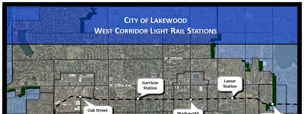
2 West Corridor Stations
3 West Corridor Overview West Corridor will open in April 2013 with high projected ridership Lakewood facilitated significant public involvement in developing station area plans and mixed use zoning Significant public investment has occurred and will continue to occur Numerous private investment opportunities exist around stations Each station area presents different context & opportunities West Corridor Opportunities
4
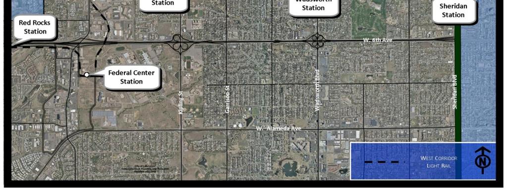
5 Shared station with Denver Both cities have adopted complementary plans RTD is designing a 800-space parking structure Commercial use along Sheridan to Colfax Avenue Great connections to parks Great location for small-scale infill development Transit Mixed Use Zoned West Corridor Stations
6
7 Walk-up station with no parking facilities Close to Rocky Mountain College of Art and Design Underutilized buildings in the area are ideal for art-related uses Several former industrial properties are ready for redevelopment New multifamily residential development is being planned Adjacent to Mountair Park A sustainable communities planning effort is currently underway West Corridor Stations
8 Lakewood Transit-Oriented Development Forum
9 A major transportation crossroads 1,000-space parking garage with dynamic pedestrian plaza planned Significant City investment in station platform and canopy upgrades The station area is zoned for mixed-use development New retail projects include Creekside and Colfax Central Future improvements to Wadsworth Boulevard will enhance access Master Infrastructure Plan completed West Corridor Stations
10 Improvements West Corridor Stations

11 Parking garage West Corridor Stations
12 Garrison Street Station A Neighborhood Station Walk-up station with no parking facilities Stable single-family neighborhoods south of the station Mixed-use opportunities between the station and Colfax Avenue The Garrison Station development is the catalyst for the area The station area plan calls for moderate densities north of 13 th Avenue The Glens, one of Lakewood s highest income neighborhoods is nearby West Corridor Stations
13 Garrison Map West Corridor Stations
14 200-space parking lot located north of the station platform Site of the future Historic Transit Museum and Restoration Center City-funded station platform upgrades underway Large Terumo BCT research and development facility Several large parcels with redevelopment opportunities in the area Master Infrastructure Plan completed West Corridor Stations
15 100 th Anniversary Historic Car 25 West Corridor Stations
16 West Corridor Stations
17 Federal Center/Union Boulevard Station The Urban Village Major employment center for the region Regional access (West Corridor, 6 th Ave, I-70) New hospital and medical facilities under construction RTD-designated Transit-Oriented Development Pilot Project Signature light rail bridge over 6 th Avenue Zoned for high-density, high-rise mixed-use development West Corridor Stations


18 Federal Center Station: 65 acres Public-Private partnership 5-8 million sf residential units New 6th Ave bridge Highlights: Shared parking structures 10% affordable housing Bike share & car share Urban design standards Energy efficient buildings District energy solution West Corridor Planning & Investments

19 Goal of LEED-ND Platinum Including requirements for: Walkable Streets Compact Development Mixed Income Community Reduced Parking Tree-lined Streets Building Energy Efficiency Building Water Efficiency On-site Renewable Energy LEED-ND at Federal Center
20 Simplified and tested standards to handle: Conservation Urban Design Compact Development Transportation Mode Split Reduced Parking Footprint Affordable Housing Access to Amenities Energy & Water Efficiency Renewable Energy Stormwater & Wastewater Low-Water Landscaping Recycled Content More LEED-ND 101
21 Advantages Pre-tested, nationally recognized standards Environmental Public health Reduced impacts Economic Rent premiums of $11/sf 4.1% higher occupancy LEED-ND 101

22 Caveats: Not a replacement for comprehensive planning Not suitable for entire city STAR Community Index - ICLEI LEED-ND 101
23 Strategies: Condition public assistance on LEED-ND certification Use components of LEED-ND to set standards Remove barriers to LEED-ND compliance Allow mix of uses Update setback requirements Lower minimum parking requirements Update landscaping requirements LEED-ND 101
Planning for TOD Implementation at a Corridor Scale
 Planning for TOD Implementation at a Corridor Scale Catherine Cox Blair, Reconnecting America Presentation to Northwest Corridor Working Group November 6, 2013 What is Reconnecting America? Reconnecting
Northwest commuter rail station US 36 BRT. Westminster Station
 Northwest commuter rail station Westminster Station US 36 BRT Westminster Center US 36 & Church Ranch Broomfield Flatiron/96 th St. US 36 & McCaslin Table Mesa Boulder Junction 13-month effort that will
Sheridan Boulevard S TAT I O N A R E A P L A N S H E R I D A N B O U L E VA R D S TAT I O N A R E A P L A N
 Sheridan Boulevard S TAT I O N A R E A P L A N 1 City of Lakewood Adopted November, 2006 S H E R I D A N B O U L E VA R D S TAT I O N A R E A P L A N The Vision The City of Lakewood s overall vision is
Staff Report and Recommendation
 Community Planning and Development Planning Services 201 W. Colfax Ave., Dept. 205 Denver, CO 80202 p: 720.865.2915 f: 720.865.3052 www.denvergov.org/cpd TO: City Council Neighborhoods and Planning Committee
JANUARY 19, 2011 CENTRAL AVENUE-METRO BLUE LINE TRANSIT-ORIENTED DEVELOPMENT IMPLEMENTATION PROJECT COMMUNITY FORUM
 CENTRAL AVENUE-METRO BLUE LINE TRANSIT-ORIENTED DEVELOPMENT IMPLEMENTATION PROJECT COMMUNITY FORUM JANUARY 19, 2011 THE MARYLAND-NATIONAL CAPITAL PARK AND PLANNING COMMISSION PRINCE GEORGE S COUNTY PLANNING
Hopkins. Development Guidelines May Overview. Sponsored by: Blake Road Corridor Collaborative City of Hopkins
 Hopkins Blake Road LRT Station Area Development Guidelines May 2015 Sponsored by: Blake Road Corridor Collaborative City of Hopkins Overview Hopkins is a dynamic community of over 17,000 residents located
New Partners for Smart Growth Conference February 5, 2010
 Dan Stroh, Planning Director City of Bellevue Planning and Community Development Bellevue, WA New Partners for Smart Growth Conference February 5, 2010 Summary of Project Long-range plan update for Bel-Red
C. Westerly Creek Village & The Montview Corridor
 C. Westerly Creek Village & The VISION Community Vision When the goals of the city are achieved Westerly Creek Village, a distinctive community defined by Montview Boulevard and Westerly Creek, is a strong
Introduction. Chapter 1. Purpose of the Comprehensive Plan Plan Organization Planning Process & Community Input 1-1
 Chapter 1 Introduction Lakewood 2025: Moving Forward Together Purpose of the Comprehensive Plan Plan Organization Planning Process & Community Input 1-1 Purpose of the Comprehensive Plan The Comprehensive
Public input has been an important part of the plan development process.
 Lakewood s Comprehensive Plan recognizes that transportation helps shape the community, and that the way the community provides for the safe and efficient movement of people affects the character of the
NEC of Central Avenue and Indian School Road
 NEC of Central Avenue and Indian School Road For this location, there are two applicable plans that provide guidance on development. The two plans include the Indian School Specific Plan (1991) and the
Ivywild On The Creek PRELIMINARY CREEK DISTRICT MASTER PLAN
 Ivywild On The Creek PRELIMINARY CREEK DISTRICT MASTER PLAN Introduction: Rejuvenating an extraordinary Creekside neighborhood THE CREEKSIDE DISTRICT The Ivywild On The Creek Neighborhood District Master
ANC 2A Presentation. November 9, 2006
 ANC 2A Presentation November 9, 2006 Introduction & Overview Applicants Boston Properties and KSI Services (project developers) The George Washington University (land owner) 2.66 acre site (former GW hospital
International Blvd. TOD Plan Public Workshop #1
 International Blvd. TOD Plan Public Workshop #1 Add photos or project images September 21 and 22, 2010 Workshop Purpose Introduce the public to the Project Review and discuss the existing conditions analysis
ULI St. Louis Technical Assistance Panel
 ULI St. Louis Technical Assistance Panel ULI St. Louis Technical Assistance Panel Sponsored by: Citizens for Modern Transit in partnership with METRO ULI St. Louis Mission Statement The mission of the
Blueprint Denver A BLUEPRINT FOR AN INCLUSIVE CITY. Executive Summary
 Blueprint Denver A BLUEPRINT FOR AN INCLUSIVE CITY Executive Summary PUBLIC REVIEW DRAFT 2 1/7/2019 DENVERIGHT BLUEPRINTDENVER Blueprint Denver: A Blueprint for an Inclusive City An Equitable City Planning
Access to the University of North Carolina at Chapel Hill, UNC Hospitals, and Chapel Hill Transit.
 M 1/ 4 1/ 2 E IL M E IL Station Family: County: City: UNC Hospitals WHY THIS STATION? University Village Orange Chapel Hill Access to the University of North Carolina at Chapel Hill, UNC Hospitals, and
Wadsworth Boulevard S TAT I O N A R E A P L A N
 Wadsworth Boulevard S TAT I O N A R E A P L A N City of Lakewood Adopted November, 2006 The Vision The City of Lakewood s overall vision is to transform the area around the light rail station into a mixed-use
ROBBINSDALE LRT STATION CDI DEVELOPMENT GUIDELINES
 August 2018 OVERVIEW The City of Robbinsdale has a prime-opportunity site in the middle of the 13 mile stretch of the Bottineau LRT corridor / Blue Line extension. Robbinsdale offers a prominent, vital,
Historic Preservation Preserve, restore or adaptively re-use historic structures and landscapes.
 Checklist for New Construction Developers of building projects in the Loring Park Neighborhood are encouraged to pursue the standards that are identified below. For large projects requiring special allowances,
WELCOME and introduction
 1 WELCOME and introduction Mobility Hub Locations within Burlington STUDY OVERVIEW STUDY OBJECTIVES The City of Burlington is developing four Area Specific Plans, one for each of Burlington s Mobility
Transit-Oriented Development (TOD) along Metro Rail Corridor Open House. A Regional Economic Development Opportunity
 along Metro Rail Corridor Open House. A Regional Economic Development Opportunity") Transit-Oriented Development (TOD) along Metro Rail Corridor Open House A Regional Economic Development Opportunity August 29, 2018 1. Project Context Metro Rail Extension Four segments for analysis: 1
Transit-Oriented Development (TOD) along Metro Rail Corridor Open House A Regional Economic Development Opportunity August 29, 2018 1. Project Context Metro Rail Extension Four segments for analysis: 1
BROOKLYN PARK / 85TH AVE LRT STATION CDI DEVELOPMENT GUIDELINES DRAFT
 August 2018 Page intentionally left blank The Brooklyn Park Library adjacent to the 85th Ave LRT Station Area. OVERVIEW The Blue Line LRT Extension / Bottineau corridor offers a unique opportunity to leverage
40 Years of Smart Growth Arlington County s Experience with Transit Oriented Development in the Rosslyn-Ballston Metro Corridor
 40 Years of Smart Growth Arlington County s Experience with Transit Oriented Development in the Rosslyn-Ballston Metro Corridor A presentation by the Arlington County Department of Community Planning,
A BLUEPRINT FOR BROCKTON A CITY-WIDE COMPREHENSIVE PLAN
 A BLUEPRINT FOR BROCKTON A CITY-WIDE COMPREHENSIVE PLAN Public Meeting October 2016 1 Plan Summary and Discussion Public Meeting May 4 2017 City of Brockton Bill Carpenter, Mayor Department of Planning
EXPO LINE COMMUNITY WORKSHOPS NOVEMBER 27 TH & DECEMBER 3 RD Los Angeles Department of City Planning
 EXPO LINE COMMUNITY WORKSHOPS NOVEMBER 27 TH & DECEMBER 3 RD 2012 Los Angeles Department of City Planning Agenda for Tonight Open House 6:00 to 6:15pm Presentation and Questions 6:15 to 6:50 Small Group
Chapter 1.0 Introduction
 Chapter 1.0 Introduction 1.1 Background The North Metro commuter rail line is part of the RTD FasTracks regional transit system expansion program to build more than 100 miles of rail transit throughout
The University District envisions, in its neighborhood
 Envisioning the University District Link Light Rail in Seattle s neighborhoods CIY OF SEALE CONCEP-LEVEL SAION AREA PLANNING RECOMMENDAION RESOLUION # 30165 EXHIBI L Vision 08.2000 he University District
DRAFT Land Use Chapter
 Stevens Creek Urban Village DRAFT 1 18 17 Land Use Chapter INTRODUCTION This Land Use Chapter describes how the Stevens Creek Urban Village will accommodate the growth that is planned for it in the Envision
Making Transit Oriented Development Work For Boonton, NJ
 Making Transit Oriented Development Work For Boonton, NJ Bloustein School of Planning and Public Policy Studio Dan Burton Loannie Dao Webster Slater Brandon Williams Ian Watson Maria Laham Nicola Mammes
Public Open House #1
 Public Open House #1 TONIGHT S AGENDA Welcome Project Overview The Big Picture The Station Area The Analysis Thoughts about Future Change Breakout Group Discussions Summation / Next Steps Project Overview
REZONING GUIDE. Zone Map Amendment (Rezoning) - Application. Rezoning Application Page 1 of 3. Return completed form to
 - Application. Rezoning Application Page 1 of 3. Return completed form to") Zone Map Amendment (Rezoning) - Application COMMUNITY PLANNING & DEVELOPMENT REZONING GUIDE Rezoning Application Page 1 of 3 PROPERTY OWNER INFORMATION* CHECK IF POINT OF CONTACT FOR APPLICATION Property
Zone Map Amendment (Rezoning) - Application COMMUNITY PLANNING & DEVELOPMENT REZONING GUIDE Rezoning Application Page 1 of 3 PROPERTY OWNER INFORMATION* CHECK IF POINT OF CONTACT FOR APPLICATION Property
Robbinsdale LRT Station. CDI Development Guidelines. August Overview
 Robbinsdale LRT Station August 2018 Overview The City of Robbinsdale may have the coolest opportunity site along the 13 mile stretch of the Bottineau LRT corridor / Blue Line extension. Located a block
East Central Area Plan
 East Central Area Plan Steering Committee Meeting March 8 th, 2018 CHUN Tears McFarlane House Vision Statement Development Opportunities Analysis Vision Elements 1. Equitable, Affordable and Inclusive
Creating Community Around Commuter Rail in Arvada Colorado. Presented By Mike Elms, AICP Community Development Director City of Arvada Colorado
 Creating Community Around Commuter Rail in Arvada Colorado Presented By Mike Elms, AICP Community Development Director City of Arvada Colorado Arvada s s Location 10 miles west of Denver A first tier suburb
40 Years of Smart Growth Arlington County s Experience with Transit Oriented Development in the Rosslyn-Ballston Metro Corridor
 40 Years of Smart Growth Arlington County s Experience with Transit Oriented Development in the Rosslyn-Ballston Metro Corridor A presentation by the Arlington County Department of Community Planning,
Draft Bergamot Area Plan
 ATTACHMENT 1 Draft Bergamot Area Plan Taskforce on the Environment April 15, 2013 www.bergamotplan.net 1 Overview WHAT IS THE BERGAMOT AREA PLAN? A Community-Based Planning Document Guiding the Future
Gold Line Bus Rapid Transit Transit Oriented Development (BRTOD) Helmo Station Area Plan
 Helmo Station Area Plan") Appendix F Gold Line Bus Rapid Transit Transit Oriented Development (BRTOD) Helmo Station Area Plan Introduction and Purpose of the Plan The Gold Line Bus Rapid Transit facility is an eleven-mile dedicated
Appendix F Gold Line Bus Rapid Transit Transit Oriented Development (BRTOD) Helmo Station Area Plan Introduction and Purpose of the Plan The Gold Line Bus Rapid Transit facility is an eleven-mile dedicated
Promoting Economic Development Through Upfront SEPA Review: Lessons from South Downtown Tacoma
 Promoting Economic Development Through Upfront SEPA Review: Lessons from South Downtown Tacoma 1 This session will focus on the City of Tacoma s South Downtown Subarea Plan and associated Non-Project SEPA
THE 355/270 CORRIDOR:
 THE 355/270 CORRIDOR: Strategic Ideas for Sustaining a Livable Work Place Project Summary ACCESS LIFE DESIGN HEALTH WORK Montgomery County Planning Department The Maryland-National Capital Park and Planning
Northwest Rail Corridor and US 36 BRT Development Oriented Transit Analysis 4.4 STATION AREA FINDINGS
 4.4 STATION AREA FINDINGS Each station is different, and each one requires a separate set of recommendations based on the vision for the site. This section outlines an initial TOD strategy and recommendations
Subregion 4 Central Avenue-Metro Blue Line Corridor Transit-Oriented Development (TOD) Implementation Project. Community Meeting April 27, 2011
 Implementation Project. Community Meeting April 27, 2011") Subregion 4 Central Avenue-Metro Blue Line Corridor Transit-Oriented Development (TOD) Implementation Project Community Meeting April 27, 2011 Overview Introduction to Subregion 4 TOD Implementation Program
Subregion 4 Central Avenue-Metro Blue Line Corridor Transit-Oriented Development (TOD) Implementation Project Community Meeting April 27, 2011 Overview Introduction to Subregion 4 TOD Implementation Program
CHAPTER 7: Transportation, Mobility and Circulation
 AGLE AREA COMMUNITY Plan CHAPTER 7 CHAPTER 7: Transportation, Mobility and Circulation Transportation, Mobility and Circulation The purpose of the Transportation, Mobility and Circulation Chapter is to
Status Report: MD 355 Project
 Status Report: MD 355 Project OCTOBER 2006 M-NCPPC MONTGOMERY COUNTY PLANNING DEPARTMENT Summary of Community Comments, and break to the Results of the MD 355 Participation Session Brookside Gardens -
THE NEIGHBORHOOD TODAY
 THE NEIGHBORHOOD TODAY CORE AREA VISION How are we Good Urbanism A Site s DNA thinking about Elements of great Unique elements urban communities embedded in a place the site and design? ELEMENTS LIKE:
DRAFT ROOSEVELT ROAD. District Recommendations. Figure 5.23 The Roosevelt Road Corridor
 CHAPTER 5 Figure 5.23 The Road Corridor Road will develop as a mixed-use corridor, emphasizing regional retail, west of the river and mixed-use development east of the river. KEY RECOMMENDATIONS 1. High
EXHIBIT A. Tax Increment Reinvestment Zone No. 1 (Town Center) First Amended Project Plan 1
 First Amended Project Plan 1") EXHIBIT A Tax Increment Reinvestment Zone No. 1 (Town Center) First Amended Project Plan 1 1 As amended by Resolution No. 2008-02-001(TR1R) of the Tax Increment Reinvestment Zone No.1, and approved to
EXHIBIT A Tax Increment Reinvestment Zone No. 1 (Town Center) First Amended Project Plan 1 1 As amended by Resolution No. 2008-02-001(TR1R) of the Tax Increment Reinvestment Zone No.1, and approved to
Plan-It Greenville (2009) Comprehensive Plan 5-Year Update
 Comprehensive Plan 5-Year Update") Plan-It Greenville (2009) Comprehensive Plan 5-Year Update What is the comprehensive plan: Collecting communitywide data Projecting future population growth Setting communitywide goals Framing policies
Plan-It Greenville (2009) Comprehensive Plan 5-Year Update What is the comprehensive plan: Collecting communitywide data Projecting future population growth Setting communitywide goals Framing policies
Transportation. Strategies for Action
 Transportation A major priority for the Overlake Neighborhood is to develop a multimodal transportation system. To achieve this system, a balance has to be found among travel, circulation and access needs;
Implementation Guide Comprehensive Plan City of Allen
 Implementation Guide 2030 Comprehensive Plan City of Allen DRAFT 2015 Implementation Guide Allen 2030 Comprehensive Plan INTRODUCTION The Comprehensive Plan serves as a guide for the growth and development
INDEPENDENCE BOULEVARD AREA PLAN
 INDEPENDENCE BOULEVARD AREA PLAN Public Meeting October 28, 2008 Tonight s Agenda Introduction 4:00 4:05 Tom Warshauer Presentation 4:05 5:00 Blake Drury Group Exercises 5:00 5:50 All Wrap Up & Next Steps
Living in Albemarle County s Urban Places
 Living in Albemarle County s Urban Places ALBEMARLE COUNTY, VIRGINIA A Closer Look at Albemarle s Approach to Managing Growth and Creating Quality Urban Environments www.albemarle.org Page 2 Living in
COMMUNITY OPEN HOUSE. March 28, 2012
 COMMUNITY OPEN HOUSE March 28, 2012 THE CASE FOR URBAN INVESTMENT One of the best things that cities can do to create jobs especially in the private sector is to improve the quality of life of their inhabitants.
St. Louis Park Wooddale LRT Station Site development guidelines
 St. Louis Park Wooddale LRT Station Site development guidelines November 2013 OVERVIEW St. Louis Park s convenient location as a neighbor to Minneapolis means you re only minutes away from some of the
Urban Design Manual PLANNING AROUND RAPID TRANSIT STATIONS (PARTS) Introduction. Station Study Areas
 Introduction. Station Study Areas") 111111 PLANNING AROUND RAPID TRANSIT STATIONS (PARTS) Introduction The ION rapid transit system will link Waterloo, Kitchener and Cambridge through a central transit corridor (CTC). There are a number
111111 PLANNING AROUND RAPID TRANSIT STATIONS (PARTS) Introduction The ION rapid transit system will link Waterloo, Kitchener and Cambridge through a central transit corridor (CTC). There are a number
3/23/2010. Brownfields & Development:
 Brownfields & Environmental Restoration and LEED for Neighborhood Development: An Inside Look at New Sustainable Communities Session Moderator: Lillian Henegar, Director of Policy & Outreach California
BRYN MAWR. Tier 2 Characteristics: Location: Lancaster Avenue from Old Lancaster Road on the east to Norwood Avenue on the west
 BRYN MAWR Tier 2 Characteristics: Transit-oriented Mixed use Along Lancaster Avenue Serve township-wide needs Civic space Employment centers Location: Lancaster Avenue from Old Lancaster Road on the east
Chapter 4. Linking Land Use with Transportation. Chapter 4
 Chapter 4 Linking Land Use with Transportation Chapter 4 59 Chapter 4 Linking Land Use with Transportation Community Design and Transportation Program Introduction Since the 1950s, the predominant development
Welcome to the Oakridge Centre Open House
 Welcome to the Oakridge Centre Open House Why is the City hosting this event? This open house is to inform you of a rezoning application submitted to the City of Vancouver to amend the existing CD-1 (Comprehensive
Building out the Regional Growth Strategy in Surrey: a Strong Centre & a Connected Transit City
 Building out the Regional Growth Strategy in Surrey: a Strong Centre & a Connected Transit City Surrey in the Metro Vancouver Region Regional Growth Strategy identifies Surrey as a major provider of housing
Silverdale Regional Center
 Silverdale Regional Center Vision for Silverdale Regional Center The Silverdale Regional Center Plan (Plan) will guide the evolution of the Silverdale Regional Center from a collection of strip malls and
Stockton Waterfront Master Plan. Waterfront Master Plan
 Stockton Waterfront Master Plan Presentation Objectives Process update Planning observations Planning Goals Planning Principles Review of planning activities Summary and next steps Planning Activities
DELIVERING ON THE TRANSIT PROMISE
 DELIVERING ON THE TRANSIT PROMISE Dena Belzer October 6, 2015 Presentation Overview 1. Puget Sound As a Transit Region: Putting SeaTac in Context 2. Starting at the Beginning: How Does TOD Work? 3. Strategies
Rapid Transit Implementation Working Group Transit Oriented Development and Transit Villages January 12, 2017
 Rapid Transit Implementation Working Group Transit Oriented Development and Transit Villages January 12, 2017 Purpose of Presentation Highlight opportunities for Transit-Oriented Development in London
KCATA Transit Oriented Development Initiatives
 KCATA Transit Oriented Development Initiatives KCATA: Regional Transportation Authority Created by bi-state compact Approved by Congress 7 County service area Quasi-governmental with broad powers Power
Sheridan Station Area Plan. Sheridan. Station Area Plan. Community Planning & Development
 Sheridan Station Area Plan Sheridan Station Area Plan Community Planning & Development Adopted June 8, 2009 Sheridan Station Area Plan Table of Contents Executive Summary i Introduction 1 Vision and Goals
Tyvola & Archdale Transit Station Area Plan. June 5, 2008
 Tyvola & Archdale Transit Station Area Plan Second Public Meeting June 5, 2008 Presentation Outline 1. Purpose and Process 2. Station Area Overview 3. Plan Recommendations 4. Comments Received and Proposed
Municipal Development Plan Update Urban Service Area and Hamlets
 ENCLOSURE 1 Municipal Development Plan Update Urban Service Area and Hamlets Priorities Committee January 24, 2017 MUNICIPAL DEVELOPMENT PLAN UPDATE SHAPING OUR FUTURE MDP Update - Agenda MDP Update Public
greenprint midtown SUSTAINABILITY ACTION PLAN 2012
 greenprint midtown SUSTAINABILITY ACTION PLAN 2012 MIDTOWN ALLIANCE SOUTHFACE ENERGY INSTITUTE RENAISSANCE PLANNING GROUP SUSTAINABLE ATLANTA PERKINS+WILL 2 GREENPRINT MIDTOWN 1. Introduction Sustainability
Tyvola & Archdale Transit Station Area Plan. May 15, 2008
 Tyvola & Archdale Transit Station Area Plan First Public Meeting May 15, 2008 Presentation Outline 1. Purpose and Process 2. Station Area Overview 3. Plan Recommendations Vision Land Use Transportation
Urban Form Case Studies
 Urban Form Case Studies Elana Horowitz Ontario Growth Secretariat Ministry of Energy and Infrastructure MINISTRY OF ENERGY AND INFRASTRUCTURE 1 Presentation Structure Role of the Ontario Growth Secretariat
Moody Centre Station TOD Area Today
 Moody Centre Station TOD Area Today WHAT IS a transit-oriented Murray Street development area? A Transit-Oriented Development (TOD) Area is a dense, walkable residential and commercial area built to support
Development Agreement Public Meeting. June 26, 2013
 Development Agreement Public Meeting June 26, 2013 Process 2007 2008 2009 2010 2011 2012 2013 Neighborhood Conservation District Petition Process Original Master Plan presented Community Forum Glen Lennox
FUTURE LAND USE ELEMENT
 FUTURE LAND USE ELEMENT GOAL I: To create and sustain a great place to live, play, and prosper Objective 1: The City of Ocala shall incorporate the principles and strategies of the Ocala 2035 Vision into
Preliminary Recommendations Tk Takoma/Langley Crossroads Sector Plan
 Preliminary Recommendations Tk Takoma/Langley Crossroads Sector Plan Vision is to achieve a Transit Oriented, pedestrian friendly Community that Celebrates and builds upon the cultural Diversity of the
In the heart of the Southern Sector is a diamond in the rough
 WESTMORELAND DART STATION AREA PLAN Map III-2.24 The Westmoreland DART Station Area In the heart of the Southern Sector is a diamond in the rough the Westmoreland Transit Station. This DART station, near
BRYN MAWR. Tier 2 Characteristics: Location: Lancaster Avenue from Old Lancaster Road on the east to Norwood Avenue on the west
 BRYN MAWR Tier 2 Characteristics: Transit-oriented Mixed use Along Lancaster Avenue Serve township-wide needs Civic space Employment centers Location: Lancaster Avenue from Old Lancaster Road on the east
POLICY AMENDMENT AND LAND USE AMENDMENT TUXEDO PARK (WARD 9) CENTRE STREET N AND 26 AVENUE NE BYLAWS 36P2017 AND 234D2017
 CENTRE STREET N AND 26 AVENUE NE BYLAWS 36P2017 AND 234D2017") Page 1 of 11 EXECUTIVE SUMMARY This application proposes to redesignate a single parcel of land in the Community of Tuxedo Park from Commercial Corridor 2 (C-COR2 f1h10) District to Mixed Use Active Frontage
Page 1 of 11 EXECUTIVE SUMMARY This application proposes to redesignate a single parcel of land in the Community of Tuxedo Park from Commercial Corridor 2 (C-COR2 f1h10) District to Mixed Use Active Frontage
, C-MS I June 3, 2016 $1500 pd chk #216918
 , C-MS-8 LOTS 21 THROUGH 40, INCLUSIVE, BLOCK 299 CLEMENTS ADDITION TO THE CITY OF DENVER SOUTHEAST QUARTER OF SECTION 34, TOWNSHIP 3 SOUTH, RANGE 68 WEST, SIXTH PRINCIPAL MERIDIAN, CITY
Rezoning Frequently Asked Questions
 elcome The City of Vancouver has received an application to rezone 6929-6969 Cambie Street and 515 est 54th Avenue from RS-1 (Single Family) District to CD-1 (Comprehensive Development) District. The proposal
Lynn Housing Authority and Neighborhood Development. Washington Street Gateway District Plan A p r i l
 Lynn Housing Authority and Neighborhood Development Washington Street Gateway District Plan A p r i l 2 0 0 8 rendering of sagamore hill from lynnway pedestrian overpass table of contents project area
Subarea 4 Indian Creek. Vision The combination of park networks and transportation amenities make Subarea 4 the greenest hub in the Corridor.
 indian creek 180 extends south from 101st Street to I-435. The I-435 and Metcalf intersection is one of the primary intersections in the Kansas City Metro Area. The area includes several residential neighborhoods
Seneca Meadows. Block 4 Locate office, technology, and medical development adjacent to I Screen views of garage structures from I-270.
 Seneca Meadows Seneca Meadows has an industrial park in its southern end and a mixed-use employment area planned for the north end. The district benefits from extensive I-270 visibility, stream valley
APPENDIX D: BACKGROUND AND VISION
 APPENDIX D: BACKGROUND AND VISION BACKGROUND A. Specific Plan Location Jordan Downs is located at 9800 Grape Street in Los Angeles, California, 90002. The Jordan Downs Urban Village Specific Plan area
Por favor, levanten la mano si necesita traduccion en espanol Please raise your hand if you need Spanish translation
 FEDERAL BOULEVARD CORRIDOR WIDE STUDY PUBLIC MEETING #1 APRIL 27, 2016 Por favor, levanten la mano si necesita traduccion en espanol Please raise your hand if you need Spanish translation HDR DESIGN WORKSHOP
Horizon 2035 Land Use and Transportation Element
 CITY OF SUNNYVALE Horizon 2035 Land Use and Transportation Element City Council Study Session March 7, 2017 Overview General Plan Context Mixed Use Villages Transportation Mode & Parking General Plan Policy
Planning for TOD Implementation at a Corridor Scale
 Planning for TOD Implementation at a Corridor Scale Catherine Cox Blair, Reconnecting America Presentation to DRCOG and the Sustainable Communities Initiative May 14, 2012 What is Reconnecting America?
Official Zoning Map Amendment Application #2018I-00077
 Community Planning and Development Planning Services 201 W. Colfax Ave., Dept. 205 Denver, CO 80202 p: 720.865.2915 f: 720.865.3052 www.denvergov.org/cpd TO: Denver Planning Board FROM: Scott Robinson,
Creating Connecting Celebrating. Lamar Street Station Area Plan
 Creating Connecting Celebrating Lamar Street Station Area Plan City of Lakewood Adopted March 2010 Table of Contents Vision 1 Station Area Highlights 2 Lakewood Citizen Participation 3 Reflecting the Comprehensive
City of Woodinville Planning Commission Study Session. Development Regulations 101: An Overview of Specific Regulatory Items To Help You in 2012
 City of Woodinville Planning Commission Study Session Development Regulations 101: An Overview of Specific Regulatory Items To Help You in 2012 Development Regulations 101 Overview of the Different Zones
A New Vision For Highland
 A New Vision For Highland ULI Austin Breakfast Wednesday April 24, 2013 Dr. Richard Rhodes President/CEO Austin Community College Panelists: Chris Riley Councilmember Place 1 City of Austin Matt Whelan
DOMINION BOULEVARD CORRIDOR STUDY AND ECONOMIC DEVELOPMENT STRATEGIC PLAN A MODEL FOR CHESAPEAKE S FUTURE
 DOMINION BOULEVARD CORRIDOR STUDY AND ECONOMIC DEVELOPMENT STRATEGIC PLAN A MODEL FOR CHESAPEAKE S FUTURE Overview I. Draft Plan Process II. Draft Plan Overview a. Market Analysis b. Master Land Use Plan
Be it enacted by the Town Board of the Town of Guilderland that the following new A (Transit Oriented Development (TOD) District) is adopted:
 District) is adopted:") Local Law No. 4 of 2018 (Adoption of 280-18A (Transit Oriented Development District) Be it enacted by the Town Board of the Town of Guilderland that the following new 280-18A (Transit Oriented Development
Local Law No. 4 of 2018 (Adoption of 280-18A (Transit Oriented Development District) Be it enacted by the Town Board of the Town of Guilderland that the following new 280-18A (Transit Oriented Development
D-O LRT Zoning Discussion. Chapel Hill Boards & Commissions October 16, 2017
 D-O LRT Zoning Discussion Chapel Hill Boards & Commissions October 16, 2017 Update on Overall D-O LRT Station Area Initiative Objectives Design and educate on principles of Good Transit-Oriented Development
Corridors. Re-vitalize our Corridors and Gateways
 Corridors Re-vitalize our Corridors and Gateways Artist s rendering from the 287 Strategic Plan, 2015 Corridors are the major throughways of Loveland but they also provide important commercial, community
Planning Commission March 14, Presented by: City of Bellingham Port of Bellingham
 Planning Commission March 14, 2013 Presented by: City of Bellingham Port of Bellingham 1 Agenda Waterfront District Background Waterfront District Proposal Overview Sub-area Plan Development Regulations
City of Long Beach. creating vibrant and exciting places
 City of Long Beach creating vibrant and exciting places Land Use Element Urban Design Element Overview of the two draft General Plan elements Discuss areas of change Economic goals of the plans Case study
Westbound: A One-day Exploration of Growth
 Westbound: A One-day Exploration of Growth Frog Pond Area 2018 UGB Expansion Proposal June 13, 2018 Growing Out: UGB Asks Four cities submitted proposals to expand greater Portland s urban footprint by
A P P E N D I X B - O P P O R T U N I T Y S I T E S
 A P P E N D I X B - O P P O R T U N I T Y S I T E S OPPORTUNITY SITES As listed in the Land Use Element, the City has identified 15 Opportunity Sites expected to be the focus of change and revitalization
Downtown Elkton Station Area Plan, Elkton, MD. Difficult enough to get support for new starts challenge to fund Houston transit
 Difficult enough to get support for new starts challenge to fund Houston transit More difficult to build Community Support for dense development at station areas Major Concerns: Traffic, Property values,