Preliminary Sketch Plan for Fort Hunter Park
|
|
|
- Roland Tate
- 5 years ago
- Views:
Transcription
 599-5188 www.dauphinc.org THOMAS COMITTA ASSOCIATES, INC.")
1 Preliminary Sketch Plan for Fort Hunter Park Public Presentation November 19, 2009 Dauphin County Parks and Recreation 100 Fort Hunter Road Harrisburg, PA (717) THOMAS COMITTA ASSOCIATES, INC. Town Planners & Landscape Architects


2 Site Survey and Wetland Delineation

3 Site Analysis Plan


4 1. What are Fort Hunter s best attributes? 2. What makes Fort Hunter distinctive and unique when compared to other nearby parks? 3. What, if anything, would you like to change about Fort Hunter? 4. What concerns, if any do you have regarding: Vehicular Traffic, Pedestrian Circulation and Parking Availability? Lighting and Accessibility of Public Gathering Spaces? Perceptions of Park Safety and Security? Conveyance of Historical and Environmental Messages? 5. Are some desirable amenities presently missing from your park? 6. What traffic-calming measures, if any, would be appropriate for Front Street? 7. If you were to re-visit Fort Hunter in ten years, what other Improvements would you hope to see? 8. If you were to tell Dauphin County representatives how best to improve your park with public funding, what prioritized improvements would you recommend? July 8, 2009 August 18, 2009 Study Committee Input

5 Overall Preliminary Sketch Plan
6 Fort Hunter Station Redevelopment


7 Complete a Market Study and Architectural Analysis to determine the best adaptive re-use strategies (e.g. welcome center, restaurant, café, produce stand, canoe/kayak rental facility. Provide terraced parking in response to steep topography, and respond to sub-surface environmental constraints inherent to the former service station use. Fort Hunter Station Redevelopment

8 Fishing Creek Restoration


9 Complete an Ecological Study/ Floodplain Restoration Analysis to determine feasibility of sediment removal for improved water quality and restored habitat. Provide educational signage to convey environmental/historic transportation messages to park visitors. Fishing Creek Restoration
10 Outdoor Amphitheater


11 Design the amphitheater in response to existing topography, solar orientation and programming needs for small or medium-sized events. Locate it where accessible from nearby parking and where planted sound barriers can be established. Outdoor Amphitheater


12 Relocate corn crib and stage a bit further north to increase lawn area seating opportunities with desirable views toward outdoor performances. Explore the use of geothermal wells in lawn area to heat and cool some park facilities. Centennial Barn

13 Pennsylvania Canal Segment Restoration


14 Clear a segment of the canal s waterway, and link a paved towpath to the parks trail system. Incorporate canal-themed play equipment and public art nearby. Pennsylvania Canal Segment Restoration
15 Meadow Establishment


16 Without displacing active recreational areas, replace a portion of the park s manicured lawn with a lower maintenance meadow. Educate trail users on the value of such habitat restoration and the use of native plantings. Meadow Establishment
17 Heckton Church


18 Incorporate parking for 52 additional vehicles, limo-sized turn-around and a guest drop-off area. Link a new scenic overlook, and church restroom facilities to the parks trail system. Heckton Church
19 Alternative Non-motorized Boat Launch Sites
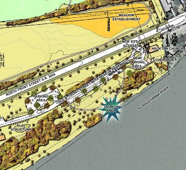
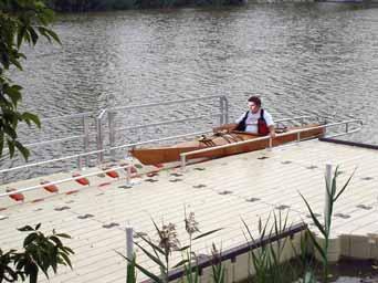
20 Seasonal Non-motorized Boat Launch Site - Direct River Access Alternative
21 Seasonal Non-motorized Boat Launch Site - Indirect River Access Alternative
22 Vehicular Circulation


23 Replace N. Front Street s paved shoulders with stabilized turf to narrow the roadway corridor, lower vehicular speeds and encourage traffic calming. Incorporate a rain garden within the N. Front Street / Fishing Creek median to improve storm water quality. Vehicular Circulation


24 Before After Add a split rail fence to delineate vehicular access to special event parking (lawn area), and utilize paved trail/access drive to reduce lawn damage during special events. Vehicular Circulation


25 Incorporate additional signage along all pedestrian trails to provide abundant educational opportunities. Create a looped trail system which includes a paved canal path and, where needed, split rail fencing to delineate public versus private spaces. Delineate three pedestrian crosswalks on N. Front Street and clearly define park entrances with oversized stone piers inspired by an existing gateway. Pedestrian Circulation


26 Resurface the Mansion s carriage drive and other walkways with gravel adhered to an asphalt paving base. Replace worn turf areas with paved pathways. Accommodate ADA accessibility throughout the park. Pedestrian Circulation


27 Install two pedestrian bridges over Fishing Creek to effectively link north and south park areas Pedestrian Circulation

 without")


28 If additional light is needed for enhanced safety and security perceptions, utilize contemporary fixtures which mimic architectural features (louvers, standing-seam metal roof) without creating a false sense of history. Consider illumination of specimen trees and building facades with fixtures set flush with the surrounding terrain making fixtures nearly invisible during daylight hours. Site Lighting
")


29 Remove all invasive plants (e.g. Euonymus, Bittersweet, Norway Maples) throughout park. Open key views toward the Susquehanna River from trail and overlook areas via selective vegetation removal. Restore period-appropriate or native plantings. Add bird blinds in several diverse park ecosystem areas. Other Suggested Site Enhancements

30 Preliminary Estimate of Probable Cost
 599-5188 www.dauphinc.org THOMAS COMITTA ASSOCIATES, INC.")
31 Preliminary Sketch Plan for Fort Hunter Park Public Presentation November 19, 2009 Dauphin County Parks and Recreation 100 Fort Hunter Road Harrisburg, PA (717) THOMAS COMITTA ASSOCIATES, INC. Town Planners & Landscape Architects
Highbridge Park Enhance the picturesque park: Provide more opportunities for healthy activity: Improve forest and ecology health:
 Enhance the picturesque park: Expose gigantic rocks and meadows Provide more opportunities for healthy activity: Improve the recreation center, athletic fields, playgrounds & restrooms Improve forest and
Community Design Guidelines. Port Wallace DRAFT
 Community Design Guidelines Port Wallace DRAFT Energy 1 2 3 Nature Movement Connections Built Form DRAFT Layout Energy 1 Nature Community Design Guidelines GREAT COMMUNITIES PROTECT, CELEBRATE, AND CONSERVE
The Vision. Photo provided by The Minervini Group. 46 Vision, Objectives & Strategies
 Vision, Objectives & Strategies The is the public framework and guide for future development of the Grand Traverse Commons. The establishes public polices for infrastructure, the preservation of natural
The following principles guide the development of goals and strategies to protect and promote these amenities:
 OPEN SPACE/PARKS/TRAILS/RECREATION GOALS/STRATEGIES Cherry Hills Village is a living environment that offers low density development, open areas, public scenic vistas, public trails and public parks. This
Ivywild On The Creek PRELIMINARY CREEK DISTRICT MASTER PLAN
 Ivywild On The Creek PRELIMINARY CREEK DISTRICT MASTER PLAN Introduction: Rejuvenating an extraordinary Creekside neighborhood THE CREEKSIDE DISTRICT The Ivywild On The Creek Neighborhood District Master
Corridor Enhancements
 Corridor Enhancements Safety is MoDOT s first priority in widening and rebuilding I-70 across the state of Missouri. MoDOT also understands that the interstate - and its interchanges and overpasses - are
MILL POND OVERLOOK. A project of the Town of Oyster Bay. Prepared by Cameron Engineering & Associates, LLP
 MILL POND OVERLOOK A project of the Town of Oyster Bay Prepared by Cameron Engineering & Associates, LLP Funded in part through an EPF grant from the NYS Department of State Project Goals & Advisory Committee
To qualify for federal Transportation Enhancement (TE) funds a project must meet two basic federal requirements:
 funds a project must meet two basic federal requirements:") Eligibility Requirements To qualify for federal Transportation Enhancement (TE) funds a project must meet two basic federal requirements: 1) Relate to surface transportation and 2) Be one of the 12 designated
Eligibility Requirements To qualify for federal Transportation Enhancement (TE) funds a project must meet two basic federal requirements: 1) Relate to surface transportation and 2) Be one of the 12 designated
II. SINGLE FAMILY RESIDENTIAL
 II. SINGLE FAMILY RESIDENTIAL Castle Rock is made up of numerous individually built houses and subdivision tracts that have been developed during the past century. Some of the tracts are diverse in architectural
Design Specifications & Requirements Manual
 11 PARKS & OPEN SPACES 11.1 DEFINITIONS... 1 11.1.1 Neighbourhood Parks... 1 11.1.2 District Parks... 1 11.1.3. Sport Parks... 1 11.1.4 Urban Parks... 1 11.1.5 Civic Spaces... 1 11.1.6 Open Space System...
Mendota Heights 2040 Comprehensive Plan Draft Vers
 4 Parks and Trails The City of Mendota Heights boasts a variety of recreational and open space opportunities. Few cities can claim access to regional trails, riverside and lakeside parks, scenic bluffs
City of Iowa City Department of Neighborhood and Development Services Department of Parks and Recreation Department of Public Works City Manager s
 RFP Pre-submittal meeting December 18, 2015 City of Iowa City Department of Neighborhood and Development Services Department of Parks and Recreation Department of Public Works City Manager s Office Background
BENJAMIN BANNEKER PARK FRAMEWORK PLAN (PLAN ADOPTION)
") BENJAMIN BANNEKER PARK FRAMEWORK PLAN (PLAN ADOPTION) COUNTY BOARD MEETING DECEMBER 16, 2017 County Board Consideration: Adopt the Benjamin Banneker Park Framework Plan and Design Guidelines Framework
BENJAMIN BANNEKER PARK FRAMEWORK PLAN (PLAN ADOPTION) COUNTY BOARD MEETING DECEMBER 16, 2017 County Board Consideration: Adopt the Benjamin Banneker Park Framework Plan and Design Guidelines Framework
Design Guidelines for the Route 30 Corridor Master Plan: Subdivision and Land Development Elements
 Design Guidelines for the Route 30 Corridor Master Plan: Subdivision and Land Development Elements East Whiteland Township- Chester County, PA Prepared by: Draft: May 7, 2018 Design Guidelines for the
Potential Green Infrastructure Strategies May 6, 2015 Workshop
 Potential Green Infrastructure Strategies May 6, 2015 Workshop Background The City of Cortland is developing the Tioughnioga Urban Headwaters Green Infrastructure Action Plan with funding from the National
Daniels Park Master Plan
 Daniels Park Master Plan Prepared for: Douglas County & The City and County of Denver October, 2007 EXHIBIT A Contents Daniels Park Overview 2 Project History & Goals 2-3 Regional Context Map 4 Park Zone
ROME WATERFRONT VILLAGE PROJECT NARRATIVE January 25, 2018
 January 25, 2018 The Rome Waterfront Village project is intended to foster the revitalization of the area between South James Street and Erie Boulevard north of the Erie Canal as well as improve public
MASTER PLAN for the EARL NEWHOUSE WATERFRONT
 MASTER PLAN for the EARL NEWHOUSE WATERFRONT on RESERVOIR POND - CANTON, MA Community Meeting #2 - Thursday, January 11 th PROJECT INTRODUCTION Project Goals: To prepare a MASTER PLAN which develops the
OPPORTUNITIES AND CONSTRAINTS - OXBOW PARK ENTRANCE AND PUT-IN
 OPPORTUNITIES AT OXBOW EXISTING WETLANDS Site is undeveloped and we can design a park that works well from the start. SAND BEACH Potential to eliminate invasive species. DEBRIS (CONCRETE, OLD CARS) VEGETATION
COMPLETE GREEN STREET CHECKLIST
 COMPLETE GREEN STREET CHECKLIST This document was developed to dissect the structure of an urban street and explore opportunities to make our streets more complete while also integrating green street strategies.
Principles for Ecological Landscape Design in Brownfield Business Parks
 Principles for Ecological Landscape Design in Brownfield Business Parks Part of USDA Forest Service research project # 00-JV-11231300-033: Aligning Social and Ecological Drivers of Urban Landscape Change
Whitemarsh Comprehensive Plan Update: Housing & Land Use. Public Workshop #3: September 20, 2018
 Whitemarsh Comprehensive Plan Update: Housing & Land Use Public Workshop #3: September 20, 2018 Agenda Welcome Process Recap What We ve Heard The Plan Framework Review of Recommended Actions Land Use Housing
OVERMOUNTAIN VICTORY TRAIL BURKE CALDELL CORRIDOR FEASIBLITY STUDY REQUEST FOR QUALIFICATIONS CALDWELL COUNTY PATHWAYS
 OVERMOUNTAIN VICTORY TRAIL BURKE CALDELL CORRIDOR FEASIBLITY STUDY REQUEST FOR QUALIFICATIONS CALDWELL COUNTY PATHWAYS Caldwell County Pathways along with our co-partners City of Lenoir, Town of Gamewell,
A Vision for Walnut Creek
 A Vision for Walnut Creek Photo: City of Clive Walnut Creek Booklet 8 of 8 Greater Des Moines Water Trails and Greenways 1 Table of Contents Booklet 1: Water Trails Strategies and Policies Booklet 2: Beaver
2011 ASLA Design Awards. Centennial Park Merit Award Design Concepts CLA, Inc. Design over $500,000 Construction Budget
 2011 ASLA Design Awards Centennial Park Merit Award Design Concepts CLA, Inc. Design over $500,000 Construction Budget 2011 ASLA Colorado Professional Design Awards Project Name: Category: Location: Const.
Design Specifications & Requirements Manual
 11 PARKS & OPEN SPACES 11.1 DEFINITIONS... 1 11.1.1 Neighbourhood Parks... 1 11.1.2 District Parks... 1 11.1.3. Sport Parks... 1 11.1.4 Urban Parks... 1 11.1.5 Civic Spaces... 1 11.1.6 Open Space System...
Reconnecting to a Forgotten River St. Cloud MN. Aaron Hanson Design Design Thesis LA 572, Thesis, Spring 2012
 Reconnecting to a Forgotten River St. Cloud MN Aaron Hanson Design Design Thesis LA 572, Thesis, Spring 2012 site context 2.5 Miles Sartell St. Cloud to Fargo 170 Miles (2 hrs 45 mins) Hwy 10 infrastructure
CAMPUS PLANNING COMMITTEE STAFF REPORT SAMARITAN SPORTS MEDICINE INSTITUTE AT OSU 10/21/2013
 Office of Capital Planning and Development; 130 Oak Creek Building; Corvallis, Oregon 97331-2001 CPC STAFF REPORT: SAMARITAN SPORTS MEDICINE INSTITUTE AT OSU CAMPUS PLANNING COMMITTEE STAFF REPORT SAMARITAN
RLRC COMMUNITIES THIEF RIVER FALLS AREA CHARACTER COMMUNITY TRAIL OPTIONS OAKLAND PARK EXISTING CONDITIONS OAKLAND PARK DESIGN DESIGN DETAILS
 THIEF RIVER FALLS AREA CHARACTER COMMUNITY TRAIL OPTIONS OAKLAND PARK EXISTING CONDITIONS OAKLAND PARK DESIGN DESIGN DETAILS 61 THIEF RIVER FALLS AREA CHARACTER Thief River Falls has a number of existing
alum creek park public workshop January 16, 2014
 alum creek park public workshop January 16, 2014 brief History Schneider Park Early 2000 s - Clean Ohio Fund - Acquisition & Invasive Species Removal SWBMP - Capital University agrees to assist with land
Community Engagement Committee Meeting #1 December 10, :30pm-8:30pm
 Community Engagement Committee Meeting #1 December 10, 2014 6:30pm-8:30pm Welcome and Introductions Dana Murdoch Minneapolis Park and Recreation Board Project Manager Ryan French Walker Art Center Director
A L F O N S O A R C H I T E C T S
 A L F O N S O A R C H I T E C T S A L M A T H E P I E R O F S T. P E T E R S B U R G A L F ALFONSO O N S O A R ARCHITECTS C H I T E C T S ALMA 1. Please demonstrate how the project fits within the Pinellas
Focus Group First Meeting Belfountain Community Centre Tuesday June 29, :00 p.m. to 9:00 p.m.
 Focus Group First Meeting Belfountain Community Centre 7:00 p.m. to 9:00 p.m. Mississauga Road/Old Main Street and Bush Street, from Olde Base Line Road to Winston Churchill Boulevard Environmental Assessment
PLANNING AND NATURAL RESOURCES COMMITTEE. Public Access Conceptual Design Alternatives for the Red Barn Area of La Honda Creek Open Space Preserve
 PLANNING AND NATURAL RESOURCES COMMITTEE R-17-56 May 9, 2017 AGENDA ITEM AGENDA ITEM 2 Public Access Conceptual Design Alternatives for the Red Barn Area of La Honda Creek Open Space Preserve GENERAL MANAGER
MCCOYS CREEK RESTORATION 30% DESIGN
 MCCOYS CREEK RESTORATION 30% DESIGN THE MCCOYS CREEK RESTORATION PLAN The restoration plan aims to reduce flooding, restore ecosystem health, expand recreational opportunities along the creek, and connect
Charles P. Johnson and Associates. Annapolis Landscape Architects
 Charles P. Johnson and Associates Annapolis Landscape Architects AGENDA Introduction Project Limits and Scope Site Analysis Opportunities & Constraints Program Goals Image Boards Design Alternatives Pros
Ship Creek Redevelopment
 Ship Creek Redevelopment Three Concepts May 2013 Cambridge ARCHITECTURE Philadelphia ENGINEERING Raleigh INTERIORS San Francisco PLANNING Washington, DC www.klingstubbins.com contact@klingstubbins.com
BISCUIT RUN PARK MASTER PLAN
 BOARD OF SUPERVISORS November 14, 2018 BISCUIT RUN PARK MASTER PLAN COUNTY OF ALBEMARLE ANHOLD ASSOCIATES Contents Project Introduction Property Background County Park Planning Process Existing Site &
appendix and street interface guidelines
 appendix five: building and street interface guidelines appendix 5 building and street interface guidelines BOULEVARDS Boulevards are generally characterized by higher levels of traffic movement at higher
Lowe Park Master Plan Update Marion, IA August 25 th, 2011
 Lowe Park Master Plan Update Marion, IA August 25 th, 2011 Lowe Park Master Plan Update Concept Plan - June 1 st, 2011 Agenda 1 - INTRODUCTION Vision Statement Aerial of Existing Condition 2 MASTER PLAN
HUMBER BAY PARK PROJECT - BUILDING CONCEPT
 WELCOME 1 Humber Bay Park, with its system of trails, rugged shoreline, and dramatic views, is a unique and rare waterfront experience within the larger metropolitan Toronto area offering a place for quiet,
Highland Falls Waterfront Redevelopment Feasibility Study Village Board Meeting March 20, 2017
 Village Board Meeting March 20, 2017 Agenda I. Public Meeting #1 Visioning Summary II. Public Meeting #2 Comment Summary III. IV. IV. Case Study: Milton Train Station Schematic Design Concepts Schedule/Next
IV. Development in the Rural Overlay District
 Intracoastal Waterway Route 17 Route 168 Great Dismal Swamp VIRGINIA NORTH CAROLINA IV. Development in the Rural Overlay District IV-1 Route 17 in Chesapeake s Rural Overlay District affords distant views
Minto-Brown Island. November 18, City of Salem, Parks & Transportation Services
 Minto-Brown Island Park Master Plan Public Meeting #1 November 18, 2014 City of Salem, Parks & Transportation Services Division, i i Public Works Welcome... and thanks for participating in the master planning
Johnson Street Bridge Public Realm Update
 Johnson Street Bridge Public Realm Update August 20, 2015 Background Johnson Street Bridge Replacement Project impacts a diverse range of stakeholders In addition to a new bridge, the project also includes
South th E ast Communit ity Centre (SECC)
") South East Community Centre (SECC) 1 New Park Design & Community Centre Update Thursday, February 8, 2018 Public Open House Thank you for attending this Open House! The town and the Consulting Team will
South East Community Centre (SECC) 1 New Park Design & Community Centre Update Thursday, February 8, 2018 Public Open House Thank you for attending this Open House! The town and the Consulting Team will
BROOKHILL NEIGHBORHOOD MODEL ZONING MAP AMENDMENT PREFACE TO APPLICATION
 BROOKHILL NEIGHBORHOOD MODEL ZONING MAP AMENDMENT PREFACE TO APPLICATION June 15, 2015 Revised: August 1, 2016 I. VISION Brookhill is a proposed community based upon the principles of Albemarle County
urban design Introduction
 ACHIEVE SP RI NGF I ELD.3 Introduction Urban Design Areas Design Areas are areas within Springfield that have a unique and recognizable character that is different from other areas in the community. The
Figure 3-1: Public Realm Plan
 3 Public Realm Figure 3-1: Public Realm Plan 3.1 Public Realm Concept The public realm concept for the Little Mountain site integrates a clear and accessible movement network with public spaces for social
7Page 91 CLEMMONS COMMUNITY COMPASS 7 COMMUNITY CHARACTER
 7 Community Character The beauty of Clemmons won t necessarily be a reflection of our past, but our future. This quote from Comprehensive Plan Steering Committee member Wayne Dodson captures the essence
Master Plan Presentation August 12, 2015
 Master Plan Presentation August 12, 2015 A vision for tomorrow... May, 13 2015 prepared for: prepared by: SITE LOCATION SITE NTS SITE ANALYSIS +/- 17.8 Ac. RESIDENTIAL HOMES 1 2 RAIL ROAD (SAFETY CONCERNS)
Jack Creek Park Capital Improvement Project
 Jack Creek Park Capital Improvement Project Public Information Meeting October 2, 2017 Consultants & Designers, Inc. Integrating Engineering and Environment 7455 New Ridge Road, Suite T Phone: (410) 694-9401
The Mobile Peninsula Corridor Master Plan Dauphin Island Parkway I 10 to Dog River
 The Mobile Peninsula Corridor Master Plan Dauphin Island Parkway I 10 to Dog River Welcome and Introductions Alice Keel Co Founder Prayer Rev. Jim Langston Fulton Road Baptist Church Comments Stewart Hanley,
COMMUNITY DESIGN. GOAL: Create livable and attractive communities. Intent
 COMMUNITY DESIGN Intent An attractive, well-designed County will attract quality development, instill civic pride, improve the visual character of the community, and create a strong, positive image for
Mississauga Waterfront. Parks Strategy - Draft
 Potential configuration for river s edge seating. Boating on Credit River: A regatta Boating on Credit River: Active enjoyment 5.2 Port Credit Memorial Park West Priority Park 5.2.1 Site Opportunities
5. Father Hennepin Blufs Park and Hennepin Island Father Hennepin Bluffs Park Supporting Initiatives (see Figure 36): 7-22
: 7-22") 5. Father Hennepin Blufs Park and Hennepin Island As described in existing conditions portion of Chapter 2, Father Hennepin Blufs Park lies on the upland portion of the park and Hennepin Island spans the
5. Father Hennepin Blufs Park and Hennepin Island As described in existing conditions portion of Chapter 2, Father Hennepin Blufs Park lies on the upland portion of the park and Hennepin Island spans the
BINGARA. Streets for People. Town Strategy. Sportsmans Hotel Streetscape
 Sportsmans Hotel Streetscape The built-out paving fronting the Council building could be extended to the frontage of the Sportsmans Hotel, allowing al fresco dining which would help activate the main street
ASHTABULA COUNTY COASTAL MANAGEMENT PLAN
 Location Ashtabula County, Ohio Planning Grantwriting ODNR, Office of Coastal Management, $25,000 Local Match $25,000 Size 21 miles of coastal area Professional Services 2012 Project Team Randy Mielnik,
Public Information Centre. Welcome
 Transportation Improvements from the Beaver Creek Bridge to the Entrance of Santa s Village District of Muskoka Municipal Class Environmental Assessment Welcome Please sign in Take a comment sheet Staff
 Health Sciences City The available land area, although limited, combined with the unique partnership between the primary institutions and the supporting partnerships of the development interests within
DESIGN REVIEW STANDARDS CITY OF LANGLEY
 DESIGN REVIEW STANDARDS CITY OF LANGLEY I. INTRODUCTION The City of Langley is fortunate to have a strong sense of place and unique quality. This comes in part from its special setting along Saratoga Passage,
CIVITAS CIVITAS CIVITAS CIVITAS CIVITAS CIVITAS CIVITAS CIVITAS CIVITAS CIVITAS CIVITAS CIVITAS CIVITAS CIVITAS CIVITAS CIVITAS
 7. The Vision 80 East River Esplanade Vision Plan Site Specific Visions Through research, analysis, outreach, and discussions with city and state agency representatives, it became apparent that a phased,
ATTACHMENT A. SILVERDALE DESIGN STANDARDS Amendments to the Waaga Way Town Center Chapter
 ATTACHMENT A SILVERDALE DESIGN STANDARDS Amendments to the Waaga Way Town Center Chapter Chapter 10. Waaga Way Town Center 10.1 Physical Identity Elements & Opportunities The Waaga Way Town Center includes
SECTION TWO: Urban Design Concepts
 SECTION TWO: Urban Design Concepts The Gardnerville Plan for Prosperity shapes economic opportunities presented by regional growth. The Urban Design Concepts provide policies and concepts for land use,
Table L-1 Summary Action Strategy. Action Item Timing Status Responsible Agency
 CHAPTER 4: CIRCULATION ELEMENT ISSUE #1: MAJOR THOROUFARES AND TRANSPORTATION ROUTES A balanced transportation system for Fontana is provided that meets the mobility needs of current and future residents
Goals & Objectives (best derived from an input
 Goals & Objectives (best derived from an input process) Goal - sets an intent of the project States the expected result or outcome of the project The trail will provide recreation and transportation opportunities
TOWN COUNCIL / PLANNING COMMISSION
 Workshop #3 TOWN COUNCIL / PLANNING COMMISSION January 20, 2011 Consultant Team In Attendance Tonight BMS Design Group Nevada City and San Francisco Michael Smiley, AICP, ASLA Partner-in-Charge Nancy L.
PREVIOUS PUBLIC PARTICIPATION BRIEF October 2014
 Comprehensive Planning During the development of the county comprehensive plan, Cultivating Community: A Plan for Union County s Future from 2007 through 2009, and three concurrent multi municipal plans
Long Branch-Wayne Local Park Renovation Project
 Montgomery Parks Long Branch-Wayne Local Park Renovation Project Community Meeting #2 September 20, 2016 Oak View Elementary School 7:00-9:00 PM Welcome / Team Introductions M-NCPPC (Montgomery Parks)
Creation of Confluence Park and Input from Vermont River Conservancy
 CITY COUNCIL Agenda Item #18-236 Date: August 22, 2018 Consent Discussion X SUBJECT: Creation of Confluence Park and Input from Vermont River Conservancy SUBMITTING DEPARTMENT: Mayor RECOMMENDED ACTION:
Design Considerations
 Essential to the development of a successful Master Plan for the Park Complex is input from the community that the park will serve. The community outreach component of the planning process included numerous
10.0 Open Space and Public Realm
 10.0 Open Space and Public Realm 10.0 Open Space and Public Realm The Public Open Space System is comprised of: outdoor spaces available for public use that are either publicly owned (e.g., parks and
FLORIN ROAD CORRIDOR Site Plan and Design Review Guidelines Checklist
 FLORIN ROAD CORRIDOR Site Plan and Design Review Guidelines Checklist Applicant s Name: Project Address: Phone: Email: Applicant shall fill out the design guidelines checklist for all guidelines applicable
An Ambitious Plan: Transforming the blighted South Platte River and surrounding environment into Denver s greatest natural resource.
 CONNECTING THE PEOPLE TO THEIR RIVER SOUTH PLATTE RIVER VISION IMPLEMENTATION PROGRAM: GRANT-FRONTIER PARK TO OVERLAND POND PARK REACH The South Platte River Vision Implementation Program (River Vision)
Prepared for: East Park Leadership Conservation Center Prepared by: CVM Construction Managers, Inc.
 Environmental Assessment East Park Reservoir Prepared for: East Park Leadership Conservation Center Prepared by: CVM Construction Managers, Inc. Environmental Assessment, East Park Reservoir 1 Contents
Glenborough at Easton Land Use Master Plan
 Public Facilities 102 7.0 PUBLIC FACILITIES 7.1 OVERVIEW This chapter describes the public facilities that will provide high-quality services in the Glenborough at Easton community, to include three schools,
4. INDUSTRIAL 53 CASTLE ROCK DESIGN
 4. INDUSTRIAL 53 CASTLE ROCK DESIGN CASTLE ROCK DESIGN 54 4. INDUSTRIAL Overview Well-designed and attractive industrial centers are the product of blending economic realities with both functional and
Call for Artists for: Design and Construction of Environmental Art Activation Story Mill Community Park, Bozeman, MT
 Call for Artists for: Design and Construction of Environmental Art Activation Story Mill Community Park, Bozeman, MT Seeking artists to design, fabricate and install art elements in the nature sanctuary
COMMUNICATION URBAN DESIGN REVIEW BOARD CITY OF DES MOINES, IOWA MAY 16, 2017 MEETING
 COMMUNICATION URBAN DESIGN REVIEW BOARD CITY OF DES MOINES, IOWA MAY 16, 2017 MEETING Subject: Recommendation Prepared by: PRELIMINARY DESIGN REVIEW OF LOCUST STREET BRIDGE CONSTRUCTION & COURT AVENUE,
Welcome! to Keller Town Hall
 Welcome! to Keller Town Hall Keller Town Center Planning a New Downtown What is Keller Town Center? A new, growing downtown district planned as an urban village A combination of retail and office spaces,
STREAM BUFFERS
 88-415 STREAM BUFFERS 88-415-01 PURPOSE In the Kansas City region and throughout the nation, vegetated stream buffers have been clearly shown to protect stream stability and related infrastructure, improve
City of Plattsburgh DRI: Downtown Streetscapes & Riverfront Access. Downtown Streetscape and Riverfront Access Design
 City of Plattsburgh DRI: Downtown Streetscapes & Riverfront Access Welcome Thank you for coming this evening. Agenda PART I - Project Context The Downtown Revitalization Program Our DRI Projects Other
CHAPTER 3. Design Standards for Business, Commercial, Industrial, Recreational and Institutional Uses
 CHAPTER 3 Design Standards for Business, Commercial, Section Number Title Ordinance Number Date of Ordinance 16-3-1 Applicability 2006-11 2008-04 07-01-08 16-3-2 Uniform Standards for Architectural Design
FY Capital Improvement Program Arroyo Projects - Central Arroyo Summary
 CENTRAL ARROYO FY 214-218 Capital Improvement Program Description FY 213 FY 214 FY 215 FY 216 FY 217 FY 218 1 Trail and Rubble Wall Restoration - Central Arroyo (77371) 1,94,66 543,848 55,812 2 Brookside
MetroParks Board Meeting 2018 Capital Improvement Projects
 MetroParks Board Meeting 2018 Capital Improvement Projects Stephen L. Avery Planning & Operations Director Last Edited: 3.12.18 Presentation Outline MetroParks Mission Statement Strategic Master Plan MetroParks
Preferred Riverwalk Alternative Components August 17, 2017:
 Preferred Riverwalk Alternative Components August 17, 2017: 1. Entrance and Future Pump Station Location: Entrance location to line up with main parking entrance to Captain Parkers and allows future Pump
PUBLIC RIGHT-OF-WAY IN THIS CHAPTER PUBLIC REALM
 PUBLIC RIGHT-OF-WAY This section provides design guidelines for improvements in the public right-of-way. The public right-of-way refers to streets, sidewalks, non-vehicular thoroughfares, parks and greenways
VEHICULAR AND PEDESTRIAN CIRCULATION
 This perspective sketch communicates the intended character and quality of a proposed streetscape design. Locate benches near a major intersection where people tend to gather. Seating and lighting provide
K+P TRAIL EXTENSION FEASIBILITY STUDY PRELIMINARY SITE ANALYSIS PLAN PREPARED FOR THE CITY OF KINGSTON NOT FOR CONSTRUCTION
 YY/MM/DD V:\2015\1415605-000 - Kingston K+P Trail Extension Feasibility\Drawings\K+P - Sheet Layout.dwg TITLEBLOCK: 790mm x 534mm OTTAWA LA 2014 PRELIMINARY SITE ANALYSIS PLAN PREPARED FOR THE NOT FOR
What We Heard Public Engagement - Stage 1
 What We Heard Public Engagement - Stage 1 Background Early planning is underway for a potential new river crossing over the North Saskatchewan River, in the northeast part of the Edmonton region. The City
Las Colonias Park Master Plan
 2013 Las Colonias Park Master Plan City of Grand Junction June 2013 Introduction Las Colonias Park, a 101 acre parcel on the edge of the Colorado River south of downtown, was deeded to the City of Grand
CHARLOTTESVILLE. Streetscape ENTRANCE CORRIDOR DESIGN GUIDELINES. Amendments adopted by City Council March 7, Design Principles...
 CHARLOTTESVILLE ENTRANCE CORRIDOR DESIGN GUIDELINES Amendments adopted by City Council March 7, 2011 2 Streetscape A. B. C. D. E. F. G. H. I. Design Principles...5 Plantings & Open Space...6 Pedestrian
Glenn Highway MP DSR. Landscape Narrative
 Glenn Highway MP 34-42 DSR Landscape Narrative Project Landscape Goals The Glenn Highway MP 34-42 Project extends through a variety of landscape types typical to the Matanuska-Susitna Valley. In general,
Town Center Design Guidelines
 Adopted by City Council on September 18, 2018 Design Theme The Draper Town Center Design Theme is defined as encompassing those architectural design styles that were prevalent in the construction of civic
Memorial Park Workshop Notes March 20, :30 10:30am
 Memorial Park Workshop Notes March 20, 2012 7:30 10:30am Black Team Veronica, Jeff, Shelly, Pat, Darcey, Gordy, Jeff Strengths River Size/Space Central Location History River Riffles in River View from/going
Official Community Plan Bylaw No. 4360, 2004, Amendment Bylaw No. 4897, 2016 (Sewell s Landing)
") District of West Vancouver Official Community Plan Bylaw No. 4360, 2004, Amendment Bylaw No. 4897, 2016 (Sewell s Landing) Effective Date: 1089612v1 District of West Vancouver Official Community Plan Bylaw
District of West Vancouver Official Community Plan Bylaw No. 4360, 2004, Amendment Bylaw No. 4897, 2016 (Sewell s Landing) Effective Date: 1089612v1 District of West Vancouver Official Community Plan Bylaw
NORTH CLAYMONT AREA MASTER PLAN COMMUNITY WORKSHOP #1 FEBRUARY 3, 2016
 NORTH CLAYMONT AREA MASTER PLAN COMMUNITY WORKSHOP #1 FEBRUARY 3, 2016 1. Introduction To the team and to the Plan Planning Partners The Claymont Community WILMAPCO New Castle County Claymont Renaissance
Georgeson Botanical Garden Master Plan
 Georgeson Botanical Garden Master Plan Alaska Chapter 2018-03-12 This Master Plan was developed by volunteers representing the Alaska Chapter of the American Society of Landscape Architects. Eliza Bober
City of Poughkeepsie Waterfront Redevelopment Strategy. Poughkeepsie Waterfront Redevelopment Strategy
 City of Poughkeepsie Waterfront Redevelopment Strategy Poughkeepsie Waterfront Redevelopment Strategy City of Poughkeepsie Prime Assets: Major Waterfront Advantages: - Central City of the Hudson River
The Auburn Plan Designing the Future of Auburn February 28, 2005
 The Auburn Plan Designing the Future of Auburn February 28, 2005 Block-by-Block Bicycle Tour Aerial survey Focus Group Meetings September 7 and 8 Design Workshops October 11, 14, and 21 Revitalization