OCEAN GROVE STRUCTURE PLAN
|
|
|
- Ashley Sharp
- 5 years ago
- Views:
Transcription

 WWW.GEELONGAUSTRALIA.")
1 OCEAN GROVE STRUCTURE PLAN Adopted 27 February 2007 (amended 23 September 2008)
2 The City of Greater Geelong (CoGG) appointed Hansen Partnership Pty Ltd - Town Planners, Urban Designers and Landscape Architects to prepare the Ocean Grove Structure Plan. Hansen Partnership engaged ARRB, MacroPlan and EarthTech to assist in expertise relating to access and movement, economic analysis and infrastructure assessment. i
3 Table of contents EXECUTIVE SUMMARY..A-i PART A STRUCTURE PLAN 1 Introduction... A Purpose of the Structure Plan...A How will this plan be used?...a The Study Area...A-1 2 Key Influences... A Policy Context...A Urban Growth...A Settlement and Housing...A Infrastructure...A Natural Environment...A Economic Development and Employment...A Rural Areas...A-4 3 The Plan... A Vision...A Role of the Township...A Principles and Directions...A Urban Growth...A Settlement and Housing...A Infrastructure...A Natural Environment...A Economic Development and Employment...A Rural Areas...A-28 PART B IMPLEMENTATION AND REVIEW 1 Implementation of the Ocean Grove Structure Plan... B-1 2 Review of Structure Plan...B-3 PART C BACKGROUND REPORT 1 Introduction... C Background...C Location...C Role of the Town...C History...C-3 2 State and Regional Plan Policy Framework... C Department of Sustainability and Environment...C Coastal Spaces (April 2006)...C Coastal Spaces Landscape Assessment Study State Overview Report C Victorian Coastal Strategy (2002)...C Great Ocean Road Strategy (2004)...C Siting and Design Guidelines for Structures on the Victorian Coast (1998)...C Melbourne 2030 (2002)...C Urban Development Program Annual Report (2005)...C Regional Strategic Documents...C G21 Draft Geelong Region Plan (2006)...C-8 ii
4 2.2.2 Bellarine Peninsula Strategic Plan...C-9 3 City of Greater Geelong Statutory and Strategic Planning Policy Framework... C City of Greater Geelong - Statutory Framework...C Urban Growth...C City of Greater Geelong Urban Growth Strategy (1996)...C City of Greater Geelong Ocean Grove Structure Plan (1993)...C Bellarine Peninsula Land Use and Residential Lot Supply Report (2005)...C Medium Density Housing Strategy...C Major current Amendments relevant to Ocean Grove...C Infrastructure...C Bellarine Peninsula Strategic Plan Ocean Grove...C Bellarine Peninsula Recreation and Leisure Needs Study (2005)...C Study of Open Space Networks ( 2001)...C G21 Ingergrated Public Transport Strategy...C City of Greater Geelong Transport Strategy (December 2003)...C Andrew O Brien Draft Ocean Grove Traffic Study March C Andrew O Brien Draft Ocean Grove Town Centre Parking and Access Study C Draft Ocean Grove Town Centre Car Parking Precinct Plan C Investigation of Road Reservation Needs Grubb Road Final Report, VicRoads, C Natural Environment...C Environment Management Strategy C City of Greater Geelong Stormwater Management Plan...C City of Greater Geelong Aboriginal Cultural Heritage Management and Protection Development Planning Protocol...C Bellarine Heritage Study (1996)...C City of Greater Geelong Biodiversity Strategy (2003)...C Buckley Park Draft Coastal Management Plan (December 2005)...C Lake Victoria Flood Study Report (May 2000)...C Economic Development and Employment...C City of Greater Geelong Retail Strategy - June C City of Greater Geelong Retail Strategy Geelong Retail Review C City of Greater Geelong Economic Development Strategy C Bellarine Peninsula Tourism Strategic Tourism Plan C Bellarine Peninsula Strategic Plan Community Vision - Tourism...C Geelong Otway Tourism Strategic Business Plan C Ocean Grove Business Association Tourism Plan C Geelong Industrial Land Study C Rural Areas...C Rural Land Use Strategy (1997)...C City of Greater Geelong Rural Residential Strategy (1994)...C-34 4 Urban Growth... C Demographic Trends...C Key Opportunities and Constraints...C Principles for Identified Development Areas...C Other Residential Areas...C Areas not considered appropriate for development at this stage...c Special investigation area North East corner of Banks Road...C-42 5 Settlement and Housing... C-43 6 Infrastructure... C-49 iii
5 6.1.1 Services Infrastructure...C Access and Movement Infrastructure...C Community Services Infrastructure...C-55 7 Natural Environment... C-59 8 Economic Development and Employment... C Retail Analysis...C Extension of the Town Centre...C Industrial Analysis...C Tourism...C-64 9 Rural Areas... C-66 List of Figures and Maps Figure 1 Study Area Figure 2 Structure Plan Figure 3 North Eastern Residential Corridor Figure 4 Future Access and Movement Figure 5 Grubb Road cross section (duplication) Figure 6 Town Centre Concept Plan Figure 7 Possible Future Development Areas Figure 8 Land Use and Built Form Figure 9 Service Constraints Figure 10 Access and Movement Figure 11 Community Services Figure 12 Environment and Open Space Map 1 Locality Plan Map 2 Extent of SLO7 iv
6 EXECUTIVE SUMMARY Ocean Grove is a major township offering a range of lifestyles, culture and natural environmental assets. While it is a designated growth town, Ocean Grove will retain its coastal urban character and protect and promote the attributes of the natural environment. As an integral part of the Bellarine Peninsula, Ocean Grove shares the attributes of other townships, the rural sector and our natural environment. Active community participation is encouraged to maintain all these linkages and attributes. Ocean Grove Community vision - Bellarine Peninsula Strategic Plan Ocean Grove is an attractive and vibrant coastal town that is experiencing strong growth as a popular destination for both permanent residents and tourists. While the town is a designated growth town, unmanaged growth has the potential to impact upon existing physical and social infrastructure and services, town character, tourist appeal, coastal landscape and rural setting as well as the sense of place and community. A number of issues and opportunities have been identified by the community including: Enhancing of the coastal environment and maintaining the rural/green spaces around the town to provide a unique attractive setting; Ensuring new development occurs inland, responds to and enhances the town character and applies sustainability principles; Improving social, community and cultural services and infrastructure, including public transport, active and passive open space, facilities for older persons and youth, bike and pedestrian access and linkages as well as broader entertainment activities and facilities; Improving traffic movement through the town; Providing for support and development of a vibrant local tourism industry; Encouraging appropriate rural based activities which adds to the diversification of tourism offered; Providing for a viable, attractive and expanded Town Centre with a diverse range of retail activities and good carparking. The Ocean Grove Structure Plan has been developed to provide a strategic planning framework for the future growth and development of the town to the year 2020 which builds upon the towns attributes, opportunities and the community vision. The Structure Plan directions have the aim that by 2020 Ocean Grove will be a sustainable sized community with: A distinctive character, making it a desirable place to live, visit and work Excellent range of retail and commercial services and employment opportunities A reputation for providing a broad range of environmentally sensitive coastal and rural based tourist activities and accommodation, associated with the beach and wetlands, arts, food and wine A mix of housing choices for all residents and which apply energy and water conservation principles A built form which creates an attractive and unique coastal character A successful and viable Town Centre which is attractive and vibrant with ample parking, a good mix of activities and convenient pedestrian access Appropriate community and social services and infrastructure which meet community needs A coastal environment which is highly valued, accessible and managed in manner which enhances and protects environmental, landscape and habitat values An interconnected environment with safe and attractive pedestrian/bicycle and open space linkages, attractive streetscapes and a functional road network serviced by a local public bus service. A-i
7 Part A identifies the key principles and directions relating to land use, urban growth and infrastructure development including: Urban growth Accommodate an increase in the town s total population of up to 21,000 persons by Accommodate the majority of this growth within a designated growth corridor to the north-east of the town between Grubb and Banks Roads with clear development principles to be applied to: residential, industrial, retail, education (primary school) and open space (including multi-purpose sports ovals) land use and facilities, staging, augmentation of services and provision of landscaping, road, bus and pedestrian linkages, community infrastructure and the use of sustainability practices; Establish a settlement boundary to maintain a compact urban form and rural/coastal setting and character; Identification of a future growth boundary to accommodate the potential for a long term population of between 25,000 30,000. Settlement and housing Support a range of accommodation and housing options, including aged care and medium density housing development particularly adjacent to the Town Centre and other existing and proposed activity centres. Support higher density development including tourist accommodation of up to 3 storeys within the Town Centre and along The Terrace between Hodgson Eggleston Streets; Ensure planning policy and controls reinforce development that is complementary to the coastal landscape and built form character of the town; Provide opportunities to achieve improved urban consolidation outcomes from designated Rural Living areas. Infrastructure Support development of the Shell Road Reserve and Surf Side Centre as a major sporting and community hub with the addition of an aquatic centre, multi-purpose community facilities with allowance for the relocation of the Bellarine Health Centre, Neighbourhood House and support services particularly aimed at older persons and youth; Undertake or facilitate open space improvements including providing improved visual and pedestrian connection to Kingston Park, enhancing the Tuckfield/Parade reserve (with picnic facilities, viewing platforms, amphitheatre, community/tourist information and carparking); Establish a safe bicycle-pedestrian path network around the town connecting the foreshore, river, Nature Reserve, Grubb, Banks and Bonnyvale Roads with linkages to Point Lonsdale, Potato Shed and Barwon Heads; Work with DOI to provide a local public bus service and support the existing transit bus shuttle scheme and establishment of a park and ride scheme during summer months to reduce pressure at main beach carparks; Improve pedestrian connections to and from the Town Centre to the beach; Support the duplication of Grubb Road in a manner which preserves significant roadside vegetation, provides an attractive town entry, safe crossing points, undergrounding of powerlines and pedestrian/cycle paths; Adopt a road hierarchy consistent with the Ocean Grove Traffic Study 2006 including sealing of road shoulders within The Terrace and investigating the connection of Tuckfield Street (north) to The Terrace; Provide for attractive themed entry treatments to the town and signage relating to major traffic routes and activities. Improve the appearance and pedestrian amenity of Shell Road, Tuckfield Street and The Parade and Orton Street with Boulevard style streetscape works. A-ii
8 Natural Environment Ensure that sensitive environmental areas including the coast, Buckley Park Foreshore, Ocean Grove Nature Reserve, Barwon River, Lake Connewarre and Lake Victoria wetlands are enhanced for public enjoyment and appreciation and protected from the impacts of urban development; Support the environmental management works of Barwon Coast, DSE and Parks Victoria; Review the Significant Landscape Overlay to ensure that it achieves the desired outcomes of vegetation protection and enhancement. Economic Development and Employment Provide for the expansion of the Town Centre within the existing Business 1 zone and northwards to The Avenue; Encourage a range of retail, business, accommodation and entertainment uses within the Town Centre with sufficient carparking, and contemporary building forms and materials, which retain a coastal town character, including building height up to 3 storeys where the upper levels are substantially setback and articulated; Provide for improved carparking opportunities and access within the Town Centre; Create a sense of entry to the Town Centre at The Parade/Hodgson Street intersection with signage, paving, planting and other design elements to encourage street activation, pedestrian movement and slow vehicle speeds; Provide opportunity to establish a small scale tourist node at the southern end of Hodgson Street (eg a café or restaurant); Provide for a future neighbourhood activity centre off Grubb Road when future population growth can support it; Provide for extension to the existing industrial estate and restricted/peripheral retail area in Grubb Road; Support the development of existing established caravan parks and accommodation uses in residential areas, particularly those close to the beach and river; Support the development of tourist accommodation within and adjacent to the Town Centre; Identify a Special Investigation Area on the north-east corner of Shell Road and Banks Road for the establishment of an eco-tourist facility. Rural Ensure land use activities on rural land within the long term settlement boundary do not prejudice future growth opportunities; Ensure urban development and non-farming based activities do not impact upon agricultural production and the right to farm; Encourage a range of appropriately scaled tourism related activities within the rural periphery of the town which are complementary to the environmental and rural setting; Part B identifies the range of planning policies and scheme provisions to be applied and developed, and the supporting actions to be implemented to achieve the key Structure Plan directions. Many of these directions will be achieved via Council s negotiations with land owners through the development approvals process, while others will involve direct engagement with and support of lead agencies such as Barwon Health, Department of Infrastructure, Department of Victorian Communities, VicRoads, Parks Victoria, Barwon Coast and Barwon Water etc. The following key changes to the Greater Geelong Planning Scheme and further strategic work is proposed over the next 5 years: The inclusion of the Structure Plan as a reference document in the planning scheme to guide planning decision making and affirm the settlement boundary; A-iii
9 The application of an Incorporated Plan/Development Plan Overlay as part of any Residential rezoning of the northern growth area to identify staging and other development principles; Application of a Development Contributions Plan over the northern growth area to apply to physical and social infrastructure provision; Application of an Industrial 3 zone to the expansion of the existing Industrial Estate to provide amenity protection to existing and future residential areas; Development of a Parking Precinct Plan for the Town Centre and extending the Business 1 and Mixed Use zone; Amending the existing Significant Landscape Overlay 7 to improve the workability of the control and undertake a more detailed landscape and urban character review of the inner residential areas of Ocean Grove to determine the appropriate mix of overlay controls to improve vegetation/landscape and built form outcomes; Development of a Streetscape and Pedestrian Plans for The Parade Orton Street route, Shell and Grubb Roads, Tuckfield Street, The Terrace, the Hodgson-The Parade Town Centre entry and key streets between the beach and Town Centre. The Structure Plan will be reviewed in 5 years to test underlining assumptions relating to growth levels and timing service and infrastructure provision and land release etc. Part C Background Information contains the detailed material which has been gathered to help identify key issues and opportunities and shape the key directions contained in the Structure Plan. A-iv
10 PART A: STRUCTURE PLAN 1 Introduction 1.1 Purpose of the Structure Plan The Ocean Grove Structure Plan is a strategic framework for the future growth and development of the town. The Plan has been prepared on behalf of the City of Greater Geelong by Hansen Partnership, in conjunction with ARRB, MacroPlan and EarthTech. Ocean Grove is an attractive and vibrant coastal town that benefits from an important strategic location within the Bellarine Peninsula. The town is experiencing consistent growth and is becoming an ever increasing destination for both permanent residents and tourists. The purpose of the Structure Plan is to identify the strategic planning issues facing the town, including community needs and aspirations, and to articulate the preferred future directions for growth, whilst protecting and enhancing the very elements which make the town distinctive and functional as an urban area and tourist destination 1.2 How will this plan be used? The Structure Plan is a tool used by the City of Greater Geelong to guide future use and development in a coordinated and orderly manner, particularly to the north of the existing town. The Plan is instrumental in determining the application of local planning policy, planning zones and overlays in a manner which manages growth in an orderly way, whilst protecting and maintaining the much valued coastal setting of Ocean Grove. The Ocean Grove Structure Plan will assist Council in determining planning permit applications and rezoning requests, as well as being used as a reference document when assessing the future roll out of infrastructure and services. As importantly, the Structure Plan for Ocean Grove seeks to provide greater certainty for residents and landowners on the future planning and development of the town up to the year The take-up of land and redevelopment will be reviewed every five years and if considered appropriate a full review of the Structure Plan should be undertaken. 1.3 The Study Area The Structure Plan applies to the town of Ocean Grove and its immediate surrounds as identified in Figure 1. The area comprises the existing urban area of the town and areas at the periphery, including land to the north of the existing urban zones and the rural interface. A-1
11 A-2
12 2 Key Influences 2.1 Policy Context Ocean Grove has been identified as having high growth capacity under the State Government s Policy Coastal Spaces. This role is strengthened by Council s Municipal Strategic Statement which designates Ocean Grove as a growth location. There is strong policy direction at both the State and Local levels for: protection of coastal environments; protection of rural environments and agricultural activities; and encouragement of good urban design of development on both public and private land. 2.2 Urban Growth The town caters for both permanent residents and holidaymakers with future growth requiring the integration of community facilities and urban services in a sustainable and accessible manner. Whilst a major town on the Bellarine Peninsula offering a range of lifestyles, cultural and natural environmental attributes, there is a need to establish clear boundaries for its future growth as part of protecting the area s fragile coastal environment. As the town expands and consolidates its urban activities there is a need to provide a sense of place and identity throughout Ocean Grove providing opportunities for interesting signage, landscaping, public art at selected locations and well defined gateways into the town. 2.3 Settlement and Housing Future growth in the residential population requires a combination of sensitively designed new residential subdivisions and infill housing. Housing development will need to offer a range of housing types and forms, from single dwellings to medium density housing, to cater for the changing needs of the community, as well as the diverse needs of the tourist market. Medium density housing should be located in close proximity to activity centres, major open spaces and public transport routes. The established character of the town is a valued element to the community. The undulating coastal setting, generally low scale of buildings and canopy trees in parts of Ocean Grove are integral to this character. 2.4 Infrastructure Basic infrastructure (drainage, water, sewerage, power, gas and telecommunications) is required to be provided in newly developed areas in a co-ordinated and staged manner and will involve augmentation of existing infrastructure. The design and appearance of the road network throughout the town will be instrumental in making Ocean Grove a safer, more attractive, cohesive and sustainable community. Social and community infrastructure including public transport services will need to be integrated into the urban area to meet current and future population needs, particularly the needs of the elderly and youth, with opportunities for co-location of facilities and multi-purpose facilities where possible. Accessibility and walkability considerations will influence the location of future social and community services and facilities in Ocean Grove. Opportunities exist to improve pedestrian and bicycle linkages throughout the town and within open spaces. Adequate provision for open space for both informal and formal recreation purposes needs to be designated to address the future recreational needs of the community. Beach access and facilities need to be improved and upgraded. A-3
13 Substantive drainage measures are needed to be put into place in new residential development to the north to minimise adverse stormwater drainage impacts on the nearby wetlands of Lake Victoria The funding of future infrastructure can be assisted by the preparation of a Developer Contributions Scheme. 2.5 Natural Environment Ocean Grove is bound by significant environmental features including coastal beaches and foreshore, Lake Connewarre and the Barwon Estuary, Lake Victoria, Ocean Grove Nature Reserve and the Begola Wetlands. These and other natural features of the town need to be protected and enhanced. Whilst various environmental overlays currently protect the natural environmental assets of the town and environs, expansion of these overlays and, inclusion of some new overlays, will be necessary if the sensitive ecosystems of the area are to be protected. There is considerable scope for consolidation and expansion of the vegetation cover throughout the town, thus reinforcing its coastal character and visual amenity. 2.6 Economic Development and Employment The existing Town Centre is the key focus for retail activity within Ocean Grove and strategies should be developed to expand and consolidate the centre, in conjunction with improved access, amenity and parking facilities, where possible. Ocean Grove Market Place is a secondary activity centre which is constrained in terms of future development. Another new activity centre to the north abutting Grubb Road will be required to meet longer term resident demand. Additional industrial land is required accommodate the future needs of the expanding population that require various goods and services from uses established in industrial areas. Tourism plays a significant role within the local economy. Support of existing tourist activities and a range of tourism opportunities will be vital to the future prosperity of the town. 2.7 Rural Areas The need to protect the rural areas to the south, east, north and west of the town from urban encroachment particularly as these areas also have strong environmental qualities. Retain the right to farm for land owners and utilise land for rural activities to maintain sustainable farming practices. The importance of rural land use activities on land to the north of the town outside the defined Settlement Boundary in ensuring the orderly and proper planning of this area in the long term. Opportunities to encourage tourism activities which benefit from a rural setting, demonstrate a need for the activity and are of a scale, design and form which will not adversely impact on the rural landscape, environmental significance of the land or opportunities for future residential expansion within the Settlement Boundary. A-4
14 3 The Plan 3.1 Vision A vision for Ocean Grove in the year 2016 has been developed through the consultative process of the Bellarine Peninsula Strategic Plan The vision for town in the year 2016 is: Ocean Grove is a major township offering a range of lifestyles, culture and natural environmental assets. While it is a designated growth town, Ocean Grove will retain its coastal urban character and protect and promote the attributes of the natural environment. As an integral part of the Bellarine Peninsula, Ocean Grove shares the attributes of other townships, the rural sector and our natural environment. Active community participation is encouraged to maintain all these linkages and attributes. The Structure Plan aims to build on these attributes and opportunities to achieve the town vision. The Structure Plan directions have the aim that by 2020 Ocean Grove will be a sustainable sized community with: A distinctive character, making it a desirable place to live, visit and work Excellent range of retail and commercial services and employment opportunities A reputation for providing a broad range of environmentally sensitive coastal and rural based tourist activities and accommodation, associated with the beach and wetlands, arts, food and wine A mix of housing choices for all residents and which apply energy and water conservation principles A built form which creates an attractive and unique coastal character A successful and viable Town Centre which is attractive and vibrant with ample parking, a good mix of activities and convenient pedestrian access Appropriate community and social services and infrastructure which meet community needs A coastal environment which is highly valued, accessible and managed in manner which enhances and protects environmental, landscape and habitat values An interconnected environment with safe and attractive pedestrian/bicycle and open space linkages, attractive streetscapes and a functional road network serviced by a local public bus service. 3.2 Role of the Town Ocean Grove, which is the principal coastal town in the municipality, is a designated growth node that can accommodate large scale residential growth beyond existing urban zoned land. The town supports both a permanent and holiday resident population with the provision of schools and community services. Other services, including retail and industrial, are generally limited to providing for household needs and requirements, noting that the range is increasing commensurate with further growth of the town. The town s sensitive coastal and environmental setting places constraints on future growth, as do various State and Local Planning Policies. However, there is scope for further expansion of the town boundaries to help strengthen and reinforce Ocean Grove s role as a hub for surrounding towns within the Bellarine Peninsula. 3.3 Principles and Directions The overall Structure Plan is outlined in Figure 2 of the report which identifies principles (objectives) and directions (strategies) relating to key planning themes: Urban Growth Settlement and Housing Infrastructure Natural Environment Economic Development and Employment Rural Areas A-5

15 figure 2: A-6
16 3.3.1 Urban Growth Ocean Grove is identified by State Government Policy Coastal Spaces (April 2006) as having High Growth Capacity. Provided the fragile coastal environment is protected, the town and environs can accommodate large scale residential growth within and beyond current zoned urban limits. One of the key roles of a Structure Plan is to identify future land use and development trends that will need to be accommodated in the future planning of the town. These trends are largely related to population growth. Population growth, and the profile of the future population, will influence: demand for additional housing and residential land; need for additional retail, commercial and industrial development; and need for future community services and facilities. The following assumptions impact on the demand for additional urban land for Ocean Grove: The population of Ocean Grove in 2001 was 10,055 people and the population in 2005 was estimated to be around 10,850 people. The future population growth of the town up to the year 2020 is based on three scenarios, adopting low (2%), medium (3%) and high (4%) growth rates. At these rates the population increase would range from 3,798 to 10,334 resulting in a total projected population for Ocean Grove ranging from 14,648 to 21,184 people, as seen in Table 1. This represents an average increase of some 271 to 738 people each year. Table 1 Projected Population Based on Low, Medium and High growth rates from 2005 population (10,850). Projected Population for Ocean Grove in 2020 (calculated from 2005 estimated population 10,850) low 2% 14,648 medium 3% 17,632 high 4% 21,184 If the high growth scenario prevails then the total population by the year 2020 is forecast to be 21,184. Over time the age profile of the population is expected to change considerably. As shown in Table 2, projections based on the high growth scenario show the population of Ocean Grove is expected to continue to age, with an increase in the proportion of young people aged between 14 and 23. This age profile will impact on all urban sectors in terms of housing needs, community services and facilities and issues of accessibility and walkability. Table 2 - Projected Change in Population by Age Group 2001 to 2020 Projected Change in Population by Age Group 2001 to Persons Age (years) A-7
17 Future growth requires constraint controlled by a Settlement Boundary. Two Settlement Boundaries shown in Figure 2 have been proposed, namely: A boundary for the lifetime of this Structure Plan to the year 2020 to accommodate a total population of approximately 21,000 and a future residential land supply of at least 10 years. The 2020 Settlement Boundary has been aligned along various allotment boundaries, the southern edge of the Ocean Grove Nature Reserve, the rear property boundaries of larger lots fronting the Bellarine Highway, Banks Road and the rear boundary of the properties fronting Bonnyvale Road. A potential boundary for the period beyond 2020 or when land supply falls below 10 years to ensure future development and location of services does not result in poor planning outcomes in the long term. Ocean Grove, whilst having the capacity for accommodating future growth as indicated by State Government policy, needs to ensure that the qualities and community values of the town are maintained. The Vision for the town notes the range of lifestyles, culture and natural environmental features that are available to the community. These need to be balanced with adequate protection of the environmental assets that come with being a coastal settlement. With a potential doubling of the population, Ocean Grove is fortunate to have land available that can accommodate future residential growth away from the environmentally sensitive areas such as the coastline, Barwon Estuary and Lake Victoria Wetlands. With appropriate servicing, including physical and social infrastructure of the future residential area, future growth can be adequately accommodated to provide a sustainable community without unreasonably impacting upon the coastal character and qualities of the town. For structure planning purposes, the ultimate population and urban development potential of Ocean Grove should be taken into consideration, assuming land between the two growth area boundaries is used for urban development in the very long term. This is to ensure that short and medium term planning decisions do not prejudice the potential long term form and structure of Ocean Grove, should the town continue to grow towards the long term (beyond 2020) Settlement Boundary. In particular, regard should be given to: the future location and size of activity centres; the future location of community services and facilities; the existing environmental features and assets; the future open space, pedestrian and cycling network; the future road network. The proposed long term (beyond 2020) Settlement Boundary is indicative only and included for consideration of the very long term potential future growth. The boundary seeks to preserve opportunities for town expansion whilst balanced with the appropriate protection of the environmental and landscape features of the land located on the periphery of the town. The land available for urban growth within the long term boundary will be constrained by landscape and environmental factors including the need for a sensitive interface with the Ocean Grove Nature Reserve and significant coastal landscapes limiting growth to small, well planned and interconnected nodes. Long term, ongoing expansion of the town beyond a total population of between 25,000 30,000 is not advocated as it is considered that this would result in a significant loss of the unique setting and character of the town that makes it popular for residents and tourists alike and runs contrary to coastal planning principles. Accordingly, a decision will need to be made in a subsequent structure plan as to whether or not it is appropriate for urban development associated with Ocean Grove to expand onto land between these two settlement boundaries involving a major consideration and examination of transport, infrastructure, social and community impacts. A-8
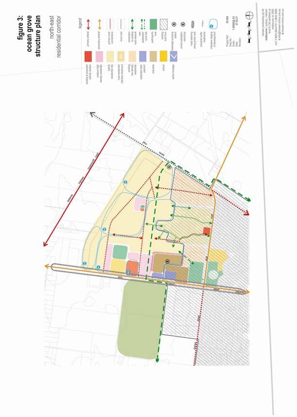
18 The majority of growth up to 2020 is to be accommodated within a north-east corridor between Grubb and Banks Road as identified in Figure 3. This growth area is to be comprehensively planned as an integrated community employing sustainability practices and will need to accommodate: a regional open space area (an area of between 4 5 ha to accommodate active sports fields); a primary school site occupying a site of 3-4ha; a local shop node of up to 1000sqm; a neighbourhood activity centre including a single supermarket and associated shops up to 7000sqm and business and community services space up to 1400sqm2 on a site up to 8ha in area able to accommodate additional community facilities; an employment node allowing for expansion of the existing industrial estate and restricted retail area. To ensure coordinated development over multiple ownerships the growth area is to be managed by the application of: an Incorporated Plan Overlay (IPO) for the entire growth area which will identify the main land use components, major road hierarchy, major pedestrian/open space principles and staging; a Development Plan Overlay (DPO) including more detailed local planning design principles (identified in the directions below) for individual land parcels or stages including undertaking of detailed drainage and flooding assessments to identify stormwater qualities and volumes, application water sensitive urban design, mitigation and infrastructure measures (including downstream works) to minimise impacts on environmentally significant land to the Ramsar wetlands east of Collendina; a Development Contributions Plan (DCP) which provides for the provision of physical and community/social infrastructure including kindergartens/childcare or neighbourhood house/community centre facilities and road, pedestrian and cycle infrastructure and connections to adjoining networks. an Industrial 3 (IN3) zone over the industrial estate extension. A staging plan is necessary to ensure orderly development that provides for an adequate supply of land for development and the provision of necessary physical and social infrastructure and services to serve the needs of residents in the growth area and broader town needs. The suggested staging plan as identified in figure 3 proposes three broad stages of development each accommodating up to 3000 residents over 5 year periods as follows: Stage 1 - To extend roughly on an L shaped front from south to north from existing residential zoned areas forming part of the Kingston Downs and Parks Estate and east of Grubb Road so as to create a competitive housing environment, improve connections between Shell and Grubb Road and to include the regional open space area; Stage 2 - To include the adjacent area and school site; Stage 3 To include areas west of Banks Road and the northern most section of the growth area as well as the activity centre. The activity centre and local shops should be completed as part of the final stage, although the activity centre could be developed in small stages commensurate with population growth in the growth area as part of a master plan process so as to provide essential local/neighbourhood community and convenience services. Substantial development of the neighbourhood centre shall not be commenced without a detailed economic impact assessment which demonstrates that there is adequate demand for additional retail floor space and that the development will not compromise the viability and primacy of the Town Centre or impact on the viability of the Market Place shopping centre. The industrial estate and restricted retail area expansion should take place in an orderly fashion in pace with supply and demand and be developed in a manner which provides for high visual amenity (built form and landscaping) to Grubb Road and utilisation of energy/water sustainable design treatments. It is acknowledged that the staging indicated in this Structure plan is preliminary only and a final staging plan should be approved as part of a subsequent Development Plan process under the Planning Scheme. Such a final staging plan must take into account catchment and drainage lines, road connections, open space, water sensitive urban design, land economics, general town planning objectives and outcomes and other practicalities including efficient servicing. It is further acknowledged that a final staging plan which takes into account these A-9
19 matters may ultimately result in the staging of the subdivision and development of the north-east corridor growth area which is materially different to the preliminary staging suggested in this Structure Plan. Urban Growth - Principles To protect the unique character of Ocean Grove as a coastal town within a sensitive environmental and significant landscape setting. To channel future residential expansion to the north-east away from the sensitive environmental areas to the south, east and west of the town. To maintain a compact urban form with all development within the identified Settlement Boundary. To ensure that new urban growth is provided with adequate provision of community and social infrastructure, particularly pedestrian access and open space. To identify a potential long term boundary beyond 2020 for the future growth of the town and to ensure that development within area between the identified urban settlement boundary and potential long term boundary boundaries does not prejudice the potential for urban growth. Urban Growth - Directions Identify a Settlement Boundary around Ocean Grove within which all urban expansion anticipated to occur up to the year 2020 will be contained. Determine a potential long term Settlement Boundary that identifies the possible ultimate extent to which the town might expand, based on logical and defensible long term planning boundaries. Retain a Rural zoning around the Settlement Boundary. Accommodate the majority of urban growth within a North-Eastern Residential Development Corridor between Banks and Grubb Road which is to be staged in an orderly manner. No expansion is proposed to the south, east and west due to physical and environmental constraints. Land between the two settlement boundaries should be used for rural and related purposes. No use or development should occur that would prejudice the long term future use of the land for urban purposes. North - Eastern Residential Development Corridor Directions The directions for this growth area including staging are shown in Figure 3 and include provision of: An integrated cluster of activities including a primary school, a neighbourhood activity centre, a local shop node and a regional park accommodating two multipurpose sports ovals. The new activity cluster is to be located on the proposed main pedestrian/bicycle link with the neighbourhood centre being the focal point of local public transport, walking and cycling networks. A range of housing options including aged care, residential density of up to 15 dwellings/ha and provision for medium density housing within 400m walking distance of the activity centre and adjacent to the school, ovals and local shopping area. A single small cluster of local shops (approximately 1000sqm). A local employment area incorporating an extension to the existing industrial estate and peripheral/restricted retail area. Up to 10% of land set aside for open space and recreation purposes including networked local parks with playgrounds (including playgrounds within close walking distance of existing residential estates to the south of the growth area), informal spaces and wetlands and an east-west pedestrian, cycle and environment corridor. A road network which provides for two local collector connections to Grubb Road and a single collector connection to Banks Road. A-10
20 Allow for the widening of Grubb Road. A road and subdivision network which provides for walkable catchments including pedestrian and bicycle linkages to the activity centre, school and open spaces, facilitate ease of access and promote public transport usage including designation of bus access and routes as well as generally providing good road and pedestrian connections with existing residential areas to the south (including a pedestrian linkage via Coolamon Close to Kingston Park). Road connections to residential areas to the south are to be designed to discourage large volumes of traffic using such routes as short cuts to Grubb or Banks Roads. Siting details of the school so that it is appropriately separated from frontage to Grubb Road. Sustainable development principles including energy and water conservation measures, water sensitive urban design, identification and management of salinity discharge areas. Stormwater mitigation design measures must be capable of ensuring downstream flows of the catchment do not exceed predevelopment rates or impact upon environmentally significant areas to the south-east. Landscape treatments for open spaces and streets (including enhancement and retention of significant indigenous vegetation). Substantial interface buffer treatment to adjoining rural areas consisting of open space linkages, reserves and local traffic roads etc. and larger lots to the Banks Road with minimal crossings to maintain a low density residential character. A 1ha zoned electricity substation within the industrial estate extension and augmentation of reticulated water and sewerage infrastructure and provision of a sewerage pump station off Banks Road. A detailed staging plan. The growth area is to be managed to achieve the above directions by the appropriate application of zones and overlays including: an Incorporated Plan Overlay (IPO). a Development Plan Overlay (DPO). a Development Contributions Plan (DCP). an Industrial 3 (IN3) zone over the industrial estate extension. There will need to be some examination of the application of Significant Landscape Overlay identified in the Coastal Spaces Landscape Assessment Study west of Banks Road so as not to compromise higher order settlement planning objectives relating to the north-east growth corridor. Principles within the DPO will need to ensure landscape and urban treatments along Banks Road are cognisant of the areas landscape character Settlement and Housing The level of housing needed to accommodate the future population within Ocean Grove is based on declining household size and increasing housing occupancy as the town shifts more from a coastal holiday destination to a town with a larger permanent resident population. The average household size in 2001 was 2.56 persons. It is expected to decrease to around 2.33 persons by The household occupancy rate however, is expected to increase with a growing permanent population. The approximate housing occupancy rate in 2001 was 76%. This rate is expected to increase significantly, subject to increases in permanent resident population within the town. The approximate number of houses required to accommodate the projected future population growth ranges from 1,630 to 4,435. This is based on the future additional population (low and high growth rates) divided by average household size of 2.33 persons. It is envisaged the majority of this will be accommodated in single detached housing, with an increasing proportion of medium density housing located around activity centres and key open space areas. The majority of new housing is likely to be within greenfield sites, with an incremental increase in housing to occur as infill development. A-11
21 A-12
22 Table 3 indicates the amount of greenfield residential land required to accommodate the projected population growth to Table 3 Future land needed to accommodate a range of Dwelling Densities up to 2020 Land supply required to accommodate future population increase (10,334) (2020) hectares (ha) 10 dwellings/ha dwellings/ha dwellings/ha The amount of land required ranges from 295 to 443 hectares, depending on the number of lots achieved per hectare. These densities are typical of a range adopted in new residential developments. It is important to note that figures are based on one dwelling per lot and, therefore, medium density housing will increase population levels. The primary growth area north-east of the town (approximately 302 hectares) will provide the majority of new housing and, be predominantly single detached dwellings. However, in an effort to create a more sustainable and compact urban area, this housing will be at a higher density (smaller lot size) than the town s older style subdivisions. Additional housing development opportunities exist in the Goandra land and existing vacant lots throughout the town itself. Medium density housing will be encouraged around the existing Town Centre, the proposed new activity centre and key open space areas. A range of accommodation to meet the diverse needs of the tourist market is also required throughout the town, with opportunities for tourist accommodation adjacent to and within the Town Centre itself. The Coolamon Close subdivision while offering sound locational attributes for conventional residential development contains an extensive and consistent cover of native vegetation makes this area unique particular given its role in enhancing the habitat values of adjoining land including Kingston Park. The area is also located close to the existing and expanded industrial estate areas. More conventional residential development and subdivision of these lots will result in a significant loss of vegetation and create potential amenity impacts. The residential growth to the north of the site however provides opportunities to achieve a pedestrian linkage between the northern growth area and Kingston Park. The existing Low Density, Special Use and Rural Living zoned land between Wallington and Grubb Roads has significant environmental or landscape attributes given the extent of significant vegetation and exposed coastal views which make these areas unsuitable for further development or residential zoning. Low Density zoned lots east of Bonnyvale Road are unsuitable for conventional residential zoning and development given their low lying nature, drainage constraints and proximity to significant environmental features. The Rural Living zoned area incorporating Ocean Grand Drive and Trethowan Avenue provides an opportunity to make a moderate contribution to urban consolidation given proximity to existing and proposed residential areas to the north and west and availability of services. The fragmented nature of land ownership will however require the development of an Outline Development Plan (ODP) prior to rezoning to residential (with a Development Plan Overlay based on the ODP) to coordinate broad development principles including street networks, protection of scattered vegetation, open space and linkages, a north south road link between Shell Road and the northern growth area, and a low density treatment to Banks Road. This area is not considered a high priority for Council and support for rezoning will be dependant on local resident capacity to coordinate the development of an Outline Development Plan and prepare a rezoning proposal supported by environmental, traffic, cultural and urban design assessments. General planning principles for this area are further detailed in Part C. The development of the Collendina Resort and Motel site to provide retirement and aged care accommodation in conjunction with tourist accommodation is supported where designed in a manner which complements the coastal setting. The site should be included within the settlement boundary and rezoning options further investigated. A-13
23 Existing caravan parks close to the beach and town centre also have the capacity to accommodate a broader range of accommodation styles including medium density housing development in the event that other tourism accommodation options are unsustainable on those sites. Settlement and Housing - Principles To ensure future housing development provides for a variety of housing sizes and types and, complements the coastal character of Ocean Grove. To promote sustainable development principles in new residential subdivisions and infill development and provide water sensitive urban design (WSUD) and stormwater treatment to ensure impacts on any environmentally sensitive land are minimised. To encourage urban consolidation and infill where compatible with established environmental, landscape and urban character. To achieve a high standard of urban design which integrates with the town s coastal character and, protects environmentally sensitive areas of the town such as the foreshore, Lake Connewarre and Ocean Grove Nature Reserve (OGNR). Settlement and Housing - Directions Support a mix of housing types, particularly around the Town Centre, including the provision of accessible and adaptable housing choices designed for disabled, aged persons and tourist accommodation. Encourage higher density housing and tourist accommodation (up to 3 storeys) in the Ocean Grove Town Centre and along The Terrace between Hodgson Street and Eggleston Street. Third floor treatments should be substantially recessed to reduce building bulk and assist in streetscape integration. Roof forms should not incorporate high pitches and should provide visual interest. Building form should provide for appropriate street activation and integration, use articulation and contemporary design treatments which contribute to a coastal town character. Focus development for medium density housing within walking distance (400 metres) of existing and proposed activity centres, major areas of public open space including beaches (where sensitive environmental design applied) and public transport routes as encouraged by the Medium Density Housing Strategy. Such development needs to be balanced with neighbourhood character objectives and residential amenity. Encourage incremental infill medium density housing throughout the remainder of Residential zoned areas, subject to neighbourhood character considerations. Encourage development which respects the coastal landscape setting of Ocean Grove by providing for contemporary design that addresses the existing scale, setback, site coverage, building spacing, forms and materials of the locality and which provides for reasonable sharing of views to the coast and foreshore. Encourage housing development which is consistent with the preferred character identified in the City of Greater Geelong Residential Character Study Support the rezoning of the Ocean Grand Drive and Trethowan Avenue Rural Living Estate to Residential subject to the development of an Outline Development Plan including details of street networks, open space and linkages, a north south road link between Shell Road and the northern growth area, and a low density treatment to Banks Road. With the exception of the Ocean Grand Drive and Trethowan Avenue Rural Living Estate the rezoning of land currently zoned Rural Living Zone (RLZ) and Low Density Residential Zone (LDRZ) to Residential is not supported. A-14
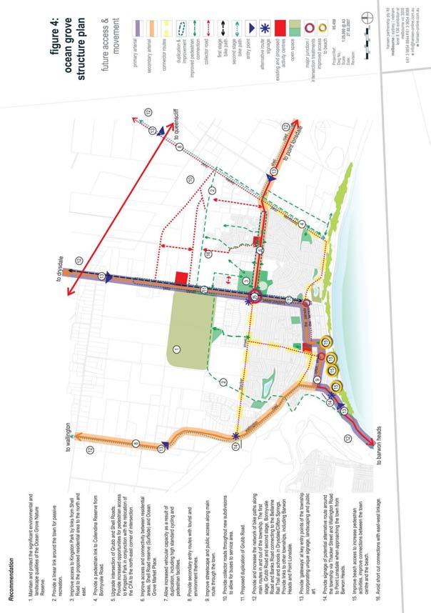
24 Amend the existing SLO7 provisions in the short term to ensure they better reflect the identified objectives of the control and provide clearer guidance to the community, Council and applicants. The alterations should provide some direction as to application on caravan park sites to minimise impacts on site viability. Undertake a review of the existing Residential Character Study and existing Environmental Rural Zone and Overlay controls to provide the basis for the introduction of a range of Overlay controls which best reflect the landscape and built form attributes of the older sections of the town. Ensure subdivision within the areas currently covered by Significant Landscape Overlay Schedule 7 has regard to the ability of lots to be developed in a manner which enables building site coverage and opportunities for site vegetation retention or establishment in a manner consistent with the prevailing building site coverage and landscape character of the area. Encourage development which provides for additional planting, protection of significant vegetation around buildings and, minimal impacts on roadside vegetation. Establish the landscape character of the new residential subdivisions by implementing early planting of street trees in new residential subdivisions. This can be achieved through the use of a Street Tree Planting Strategy for Ocean Grove that would define planting themes in certain precincts Infrastructure The proposed Settlement Boundary for Ocean Grove to 2020 coincides with the co-ordinated provision of necessary services (water, drainage, sewerage, power, gas and telecommunications) for this urban expansion. The area to the north-east of the town can accommodate future urban development in terms of these basic services but will require augmentation of reticulated water and sewerage services by the developer and Barwon Water including provision of a sewerage pumping station off Banks Road. Powercor have also indicated that a zoned substation requiring a site area of up to 1ha will be required to service future development within this growth corridor. Figure 4 sets out the access and movement network associated with the future growth and expansion of Ocean Grove. The plan notes the importance of providing improved connections between existing and proposed estates, connections to Shell Road community hub, alignment of the environmental town link, links from the Town Centre to the beach with improved and connected pedestrian and bicycle paths being a priority. Figure 5 addresses the upgrade of Grubb Road providing an indicative cross section of the proposed duplication including bike lanes and a shared pedestrian and bicycle path whilst maintaining the vegetation qualities of the abutting road reserve land. The status and scheduled upgrade of the three roads that provide access to the town requires consideration in addition to parking and access within the Town Centre, a review of the road hierarchy, treatment to key intersections and an alternative route around the town. The Structure Plan supports the directions of the Bellarine Peninsula Leisure and Recreation Needs Study 2005 and Bellarine Peninsula Community Service Plan in relation to the provision social and community infrastructure facilities including improving the leisure, recreation and open space needs of the community by improving both the provision of open space and walkability to services and facilities for all age groups and planning for improved community and social service provision within the town. The addition of the Bellarine Aquatic Centre and potential for Bellarine Health Centre and Neighbourhood house to be clustered around Surfside, provides a major community hub of social infrastructure that is adjacent to schools and centrally located to provide access for the wider community. The provision of these community services is highly valued by the residents of the town and Bellarine community, improving the diversification of services that are available for varying age groups to enjoy. There are currently limited public transport linkages to Geelong and other centres from Ocean Grove. An existing bus transit scheme is operated on behalf of the Barwon Heads-Ocean Grove traders. A park and ride A-15
25 scheme has also been advocated to assist in relieving pressure on parking around popular beach access points during summer where small buses can depart from larger car parks located throughout the town including the Town Centre, Ocean Grove Market Place, proposed new activity centre on Grubb Road, Surfside etc. A local bus system should be come sustainable with forecast population growth and should be accommodated for within the planning of activity centres and new urban development. In the interim other local transport schemes should be supported. Infrastructure - Principles To encourage the provision of a range of social and community services meeting the needs of current and future populations of both the town and wider Bellarine Peninsula. To provide adequate levels of public open space, both within the existing and proposed residential areas, to cater for the passive and active recreation needs of the community. To improve pedestrian and cycling movement, access, safety and connectivity throughout all areas thus enhancing recreational activity and linkages for the community. To provide an improved transport and movement network throughout the town and linking with surrounding settlements. To ensure new development adequately addresses stormwater drainage including downstream storage and management requirements and employs WSUD principles. To ensure the appropriate augmentation of water supply, sewerage and electricity infrastructure and development of Police and emergency services infrastructure; To provide a sense of place and identity to the town through the inclusion of unique and interesting signage, landscaping and public art at the gateways of the town. To promote and reinforce key access points to the beach. Infrastructure - Directions Community and social infrastructure Support development of the Shell Road Reserve and Surf Side Centre as a major sporting and community hub with the addition of an aquatic centre, multi-purpose community facilities and which allows for the accommodation of the Bellarine Community Health Centre, Neighbourhood House and other support services particularly aimed at older persons and youth. Support establishment of community support services within the town centre. Ensure adequate aged care facilities are provided throughout the town and where possible within convenient access to an activity centre and medical facilities. Work with the Department of Infrastructure to investigate opportunities to provide a town bus service which includes linkages to the Potato Shed and linkages to Drysdale-Clifton Springs and Barwon Heads. Investigate opportunities for a park and ride scheme during school holiday periods and busy weekend periods. Support the relocation of the CFA to the corner of Shell and Grubb Roads in a manner which enhances linkages to Kingston Park. Open space and recreation: Establish a safe bicycle-pedestrian path network around the town connecting the foreshore, river, Nature Reserve, northern growth area, Grubb, Banks and Bonnyvale Roads with linkages to Point Lonsdale, the Potato Shed and Barwon Heads. Investigate the opportunity to provide a pedestrian and cycling access A-16
26 path within the firebreak extending along the southern boundary of the Ocean Grove Nature Reserve in consultation with Parks Victoria. Work with Barwon Coast to develop a pedestrian and cycle linkage through The Spit to link Barwon Heads and Ocean Grove. Work with Barwon Coast and Parks Victoria and other agencies to create sensitive pedestrian connections along the coast linking the Barown River, Lake Connewarre, The Spit and Lake Victoria environments Including improving sensitive pedestrian connections through Buckley Park. Provide adequate provision of both informal and formal open space as recommended by the Bellarine Peninsula Recreation and Leisure Needs Study (2005) to address the future recreational needs of the community. Support establishment of a playground within existing open space within the Kingston Downs Estate. Improve visual and pedestrian connections to Kingston Park. Enhance community and visitor utilisation of the Tuckfield/Parade Reserve with picnic facilities, viewing platforms, amphitheatre, community/tourist information and carparking. Provide pedestrian access to Collendina Reserve from Bonnyvale Road. Services: Traffic: Support the augmentation of electricity, water supply and sewerage infrastructure. Seek to have overhead powerlines relocated underground within the Town Centre and along major collector roads. Ensure the development in the north-eastern residential corridor includes appropriate stormwater treatment and drainage with the provision of down stream stormwater infrastructure. Support the duplication of Grubb Road and its role as the main entry into Ocean Grove for traffic coming from Geelong, subject to adequate protection of significant vegetation along the road reserve. Wallington Road is to maintain its existing function as a secondary and alternative entry, focussed on providing a tourist route and a more scenic approach into Ocean Grove. Banks Road is to remain as a secondary entry point to Ocean Grove, retaining a semi-rural appearance and fulfilling the roles of an access role to the beach at Collendina and as a safe bicycle route providing linkages to the Bellarine Rail Trail, the Potato Shed and secondary schools in Drysdale. Establish signage to encourage through traffic to use an alternative route (Wallington - Thacker Street Shell Road) around the town, in preference to going through the Ocean Grove Town Centre. Signage should be located at three intersections: Barwon Heads Ocean Grove Rd and Orton Street roundabout; Wallington Road and Thacker Street intersection; and Thacker Street/Grubb Road/Shell/Tuckfield Road roundabout. Retain existing roundabout at the intersection of Thacker Street/Grubb Road/Shell Road/Tuckfield Street. Consider signalising the intersection after duplication of Grubb Road and, subject to traffic volume increases. Undertake intersection improvement works at corner of Orton and Presidents Parade. Maintain The Parade as the main thoroughfare through the town however further investigate the opportunity to connect Tuckfield Street (northern section) to The Terrace for the purpose of: o o Connecting to Emperor Drive to improve road connectivity between Collendina and old Ocean Grove; Providing flexibility for traffic to access the Ocean Grove Town Centre along The Terrace; A-17
27 Surfacing the shoulders of The Terrace between Hodgson Street and Tuckfield Street to improve the access and movement. Review the role of The Parade and The Terrace after 5 years to see if further modification or change needs to occur. Linkages, Boulevards and Streetscapes: Establish a dedicated regional cycle path along both Grubb and Banks Roads, connecting to the Bellarine Rail Trail, Potato Shed and secondary schools. Grubb Road is to be the first priority associated with the duplication of the road. Upgrade Grubb Road and Tuckfield Street as a major coastal boulevard. A streetscape plan should be prepared for this route which seeks to achieve the following: o o o o o o o duplication of Grubb Road from the Bellarine Highway through to The Parade; strong informal coastal landscape theme; a landscaped central median in Grubb Road which reinforces the remnant treed vegetation; landscaped verges; protects local indigenous vegetation and retain existing trees and vegetation, wherever possible; a dedicated cycle path (separate from footpaths) along Grubb Road that provides a connection to Drysdale/Clifton Springs and the Bellarine Rail trail to the north; limits direct access to Grubb Road from properties abutting the road. Development of properties abutting Grubb Road and Tuckfield Street shall accommodate setbacks and landscaping which complement the coastal landscape theme of the roads. Strengthen the role of Shell Road as a major informal coastal boulevard. A streetscape plan should be prepared for this route which seeks to achieve the following: o o Provision of high standard cycling and pedestrian facilities; Appropriate linkages and crossing points linking key commercial and community facilities along this activity spine including Kingston Park, Surfside Centre and the Market Place Shopping centre. Upgrade the appearance and amenity of the main road through Ocean Grove, which follows The Parade Orton Street route. A streetscape plan should be prepared for this route which seeks to achieve the following: o o o improved provision of footpaths along the route; underground powerlines; improve and provide a consistent coastal landscaping theme along the route; Encourage new housing and development along The Parade Orton Street route which provides for low, transparent fence treatments; discourages the erection of high solid fences; provides for landscaped front setbacks that complement the coastal landscape within the road reserve and enhance the overall appearance of the road corridor. Improve pedestrian access to the beach from the Town Centre along Hodgson Street. This route is to be emphasised by landscape treatments. Investigate improvement of other beach linkages including Presidents Avenue, Field Street and Wallington Road. Provide unique and interesting signage, key planting and landscaping, urban art installations, banners etc at the key gateways to Ocean Grove e.g. Barwon Heads Ocean Grove near the intersection with Surf Beach Road; Wallington Road near the intersection with Thacker Street; and Grubb Road and Shell Road near the intersection with Banks Road. All future road works and traffic calming treatments should provide a high level of pedestrian safety and visual amenity. A-18
28 A-19
29 A-20
30 3.3.4 Natural Environment Ocean Grove is bound by significant environmental features such as the foreshore, Lake Connewarre (Barwon estuary) and Lake Victoria. Other features include Ocean Grove Nature Reserve and the Begola Wetlands. These natural features are integral to the habitat and biodiversity values of the local and wider environment, as well as contribute to the overall identity of the town and its community. The Settlement Boundary excludes these key environmental features from urban development. The town has a number of environmentally themed overlays that cover various parts of the town. The Department of Sustainability and Environment Coastal Spaces Recommendations Report (April 2006) proposes application of the Significant Landscape Overlay (SLO), over the Barwon River Estuary to the west of the town and along the coastline between Ocean Grove and Point Lonsdale and, Lake Victoria and Yarram Creek extending to Banks Road. The application of this overlay is supported by the Structure Plan ensuring that any development is undertaken in a manner which does not detrimentally impact upon the coastal landscape and areas of environmental significance. The application of the Overlay to designated growth areas west of banks Road will require examination so as not to conflict with these growth directions which were not finalised at the time of the landscape assessment preparation. The application of the Overlay to the north-east growth area is not advocated however directions are included for this precinct aimed at managing this landscape interface. Within this environmental context there is the potential for new residential development to the north of the town to have adverse impacts upon the quantity and quality of storm water runoff into the nearby wetlands of Lake Victoria. Proposed new development in this area will need to ensure that substantive measures are put in place to successfully mitigate drainage issues. The key landscape features of the town and environs are managed by public land managers, such as the Barwon Coast Foreshore Committee of Management, Parks Victoria and the City of Greater Geelong. Ongoing management of these areas by the relevant management agency to ensure these areas are protected and enhanced in the long-term is supported. The established character of the town is also a key feature valued by the community. The character evolves from the undulating coastal setting, generally low scale buildings, and canopy trees which exist through parts of the town. However, the level of vegetation throughout some neighbourhoods varies considerably, with new residential areas to the north having little vegetation. A Landscape Character will need to be established for the existing and future urban areas thus consolidating the overall character of the Town. Some of the significant treed and landscaped areas include the original part of Ocean Grove town which extends to the foreshore area known as Buckley Park Foreshore Reserve, as well as Goandra Estate and the Ocean Grove Nature Reserve. All of these areas require adequate protection of their sensitive ecological qualities to ensure development does not unreasonably encroach on these areas. Further work is recommended to review the existing Planning Scheme overlays and a review of the Character Study to identify key design, landscape and environmental objectives and the application of appropriate overlays and zones. This recommendation is identified in Part B Implementation and Review Section of the Structure Plan. The Corangamite Catchment Management Authority have undertaken some preliminary salinity mapping in the identified north-eastern growth area identified a small salinity discharge area. The development principles outlined in the Structure Plan identify that such areas need to be properly managed however the implementation of a Salinity Management Overlay over the identified discharge area. Environment - Principles To protect the environmental and landscape features of the town. To facilitate greater utilisation of existing parkland, whilst balancing protection of the existing landscape and environmental qualities of the public open space. A-21
31 To ensure environmental sensitive areas including the Coast, Buckley Park Foreshore Reserve, Goandra Estate, Ocean Grove Nature Reserve, Barwon River / Lake Connewarre and the Lake Victoria wetlands are protected from development pressures. To ensure the existing and future neighbourhood and landscape character is adequately protected and enhanced with additional landscaping appropriate to the town s coastal location. Environment - Directions Ensure protection and management of significant vegetation Encourage the implementation water sensitive urban design measures for drainage and stormwater, energy conservation and water reuse within all residential, commercial and industrial development. Provide wide, treed passive open space corridors throughout the new residential development to the north-east. Protect the environmental qualities of Buckley Park Foreshore Reserve to ensure that the sand dune structure and landscape characteristics are adequately protected and that pedestrian activity is appropriately managed in consultation with key agency stakeholders. Support the implementation of the Buckley Park Coastal Management Plan and Barwon Coast Foreshore Strategy. Support the ongoing environmental management activities and improvements in infrastructure, restoration/regeneration of habitat and access to coastal public land by Barwon Coast, DSE and Parks Victoria. Undertake a range of landscape improvements along major road and pedestrian linkages as identified within the Structure Plan. Review the application of the Significant Landscape Overlay 7 and Environmental Rural Zone to ensure that these controls best deliver the intended environmental outcomes. Apply a Salinity Management Overlay to known salinity discharge areas Economic Development and Employment As the population increases so will the demand for increased consumer goods and services. The City of Greater Geelong Draft Retail Strategy 2006 supports growth of retail floorspace within Ocean Grove over the period to This position is supported by the Structure Plan as meeting the future retail needs of the community. The town currently has retail activities located in three locations namely: The Town Centre which accommodates the majority of the towns retail premises; Ocean Grove Market Place which is a newer shopping centre that includes retail premises; and A small strip of convenience shops along Madeley Street and a number of individual convenience shops throughout the town. The existing Town Centre should remain at the key focus for retail activity within Ocean Grove to foster activity and vitality of the town. The centre has some key anchors (supermarket, post office, bank etc) along with a proposed Country Target store within the next months. The Background Report acknowledges that with the future growth of the town, additional retail and commercial floorspace will be required to meet the needs of both residents and tourists. Despite some limited vehicular accessibility and parking issues (these will be further investigated in the future), the Town Centre is viewed as being able to accommodate an improved range of retail goods and services. This is to occur in the following ways: Extension of the Town Centre to the north (to The Avenue between Hodgson Street and Presidents Avenue) to provide commercial, community and entertainment uses with residential and tourist A-22
32 accommodation at upper floors and integrated with the rest of the centre with appropriate consolidated carparking including decked parking areas (above ground and/or basement level), pedestrian connections and active street frontages (including street frontage to pedestrian connections and carparking areas); Increasing the density of development within the Centre itself by allowing development up to 3 stories (up to 12.0m with upper levels which are highly recessive with a significantly reduced footprint than lower levels) to accommodate office, entertainment and accommodation uses above ground level; Allow for consolidation of the town centre by supporting retail development within the existing Business 1 zoned area to the south-east corner of Hodgson Street and The Parade, providing for specialist retail, office and community/medical support services, accommodation and or entertainment uses (including a cinema); Inclusion of the former CFA site and adjoining land to the south within a Mixed Use Zone to accommodate medical/community and office uses. The key issues for ensuring appropriate development of the Town Centre include: Providing an efficient means of vehicle (including public bus) and pedestrian access to the Town Centre and carparking areas; Providing well designed consolidated carparking areas and ensuring that new development provides adequate carparking, with no net loss of centre carparking a Car Parking Precinct Plan will assist this objective; Providing for a sense of entry, low vehicle speeds, high level of pedestrian amenity and crossing points to the south-east; Contemporary design and built form of appropriate scale consistent with the town s coastal character. Figure 6 illustrates planning and urban design principles and expansion opportunities for the Town Centre. Ocean Grove Market Place is a secondary activity centre that serves the newer eastern and northern neighbourhoods of Ocean Grove. The centre is bound by residential properties and therefore has very limited capacity for expansion unless upwards. It is envisaged therefore that with the expected growth of Ocean Grove an additional activity centre to the north abutting Grubb Road will be required to serve the new residential population. A smaller local shop area will also be required in the growth area to provide localised convenience needs. The development and growth of these centres are included within the Urban Growth directions. The expansion of the Madeley Street shops is not anticipated however the area would benefit from streetscape works to improve the visual setting and pedestrian amenity. The existing Grubb Road industrial precinct will require expansion to accommodate future floor space demands commensurate with town growth and to provide town based employment opportunities (a total of up to 20 additional hectares is envisaged over the life of the Structure Plan). Opportunities exist to extend the industrial estate initially to the east via the existing Barwon Water land holding in Smithton Grove and ultimately northwards. Rezoning should only be undertaken in stages so as not to jeopardise the take-up of vacant properties within the existing industrial area. Establishment of separate industrial zoned areas outside this precinct is not supported. Tourism plays a significant role within the town s economy. The further growth of the local tourism industry is strongly advocated in a manner which supports existing accommodation providers and encourages a broadening of the tourist offer (activities, infrastructure, services and accommodation) to provide employment benefits and spread tourism activity beyond a summer peak. Tourism opportunities supported within the Structure Plan include: Supporting development of existing caravan parks and motels including broadening of accommodation type mix particularly on sites close to The Town centre or the beach; Supporting new accommodation opportunities within and adjacent to the town centre; A-23
33 Supporting investigation into an eco-tourist facility at the corner of Banks and Shell Road; Opportunities for peripheral rural area based tourist activities related to food and wine, art etc (refer Rural section) Revitalisation of the Collendina Resort for tourist accommodation and entertainment services; Utilising existing parks such as Ocean Grove Park, The Parade/Tuckfield reserve etc for markets or other events; Supporting further tourist information services; Foreshore linkages and improvements, pedestrian and bicycle linkages, signage etc (refer Environment and Infrastructure directions). Associated with these economic development outcomes is the generation of more local employment opportunities a benefit which assists in building a sustainable community for Ocean Grove. Economic Development and Employment - Principles To consolidate retail and commercial activity within the Town Centre as the key retail focus of the town with opportunities for residential and tourist accommodation on upper floors provided parking and access requirements are met. To encourage a contemporary built form in the Town Centre which complements the coastal setting, contributes to an improved coastal character for the Centre and, promotes increased tourism. To set aside adequate land for a new neighbourhood activity centre abutting Grubb Road that provides retail and commercial goods and services meeting the needs of the new residential population to the north of the town. To set aside land adjacent to the north and east of the existing industrial area abutting Grubb Road to accommodate additional industrial and restricted retail commercial activities to service the needs of the increasing population. To encourage the provision of additional accommodation and tourist related services and infrastructure which is responsive to the coastal setting and environment. Economic Development and Employment - Directions Maintain the existing Ocean Grove Town Centre as the major activity centre serving Ocean Grove and nearby towns. Expand the Town Centre to the north to allow for increased retail and commercial activity, including offices, residential and tourist accommodation on upper floors provided these activities fulfil relevant parking and access requirements. Maintain the role and function of the Ocean Grove Market Place as a neighbourhood centre providing a range of retail services. Maintain the local shopping role and function of the Madeley Centre providing convenience shopping to its immediate surrounds but improve character and amenity by undertaking streetscape works. Allow for the development of a new Neighbourhood Activity Centre and local shop area to service the needs of the future residential area to the north of the town. Development of the neighbourhood centre shall not be commenced without a detailed economic impact assessment which demonstrates that there is adequate demand for additional retail floor space and that the development will not compromise the viability and primacy of the Town Centre or impact on the viability of The Grove shopping centre. Support the establishment of a tourist information facility within or adjacent to the Town Centre. Support the development of entertainment facilities such as a cinema within the Town Centre or within other multipurpose regional facilities including Surfside or the Potato Shed. A-24
34 Encourage the use of open spaces such as Ocean Grove Park, Kingston Park, The Parade/Tuckfield reserve etc for markets, summer open air cinema/plays or other community events and activities. Investigate the opportunity to establish a small scale tourist node at the southern end of Hodgson Street, possibly including a café or restaurant and passive open space area. Support development of existing caravan parks and motels including broadening of accommodation type and mix particularly on sites close to the Town Centre or the beach. Supporting new accommodation opportunities adjacent to the beach and town centre including an area bounded by The Terrace, Hodgson Street, The Parade and Eggleston Street. Support investigation into an eco-tourist facility at the corner of Banks and Shell Road. Support redevelopment of the Collendina Resort for tourist accommodation and entertainment services. Ocean Grove Town Centre - Directions Expand the Town Centre north to Ocean Grove Park, in the area bound by The Parade, The Avenue, Presidents Avenue and Hodgson Street. Rezone this area from a Business 2 to a Business 1 Zone. The northern Town Centre expansion is to be integrated with the rest of the centre with: o Appropriate consolidated carparking including decked parking areas (above ground and/or basement level); o Pedestrian connections including a connection from The Avenue and Ocean Grove Park to The Terrace with appropriate road crossing treatments, landscaping, public art and street furniture; o Active street frontages (including street frontage to pedestrian connections and carparking areas); o Provision of public transport access and drop off/pick up infrastructure. Support the development of the existing Business 1 zone to the east of Hodgson Street between The Terrace and The Parade in a manner which provides for specialised retailing, cafes, restaurants with offices and community/medical support services, accommodation and entertainment uses at upper levels. A consolidated site opportunity with improved carparking can be assisted by the disposal of the small park and Council carpark. Rezone the former CFA depot on the south-east corner of Hodgson Street and The Avenue and land to the immediate south to Mixed Use to support a range of uses including office, medical, community and accommodation. Support use and development within the Town Centre which: o Contributes to the mix of commercial, community, accommodation and entertainment uses within the Town Centre which meet the daily needs of the community and encourage street life and tourist visitation; o Encourages infill development on vacant, older and under developed sites (such as the post office site); o Reinforces The Terrace as the main street focal point of the Centre and as the tourist, food and beverage hub of Ocean Grove, complemented by an array of retail premises and supported by the supermarket; o Focuses accommodation and office or non retail functions to levels above ground floor; o Promotes building heights of 2 to 3 storeys (up to 12.0m) throughout the Town Centre. Third storey treatments should be articulated and substantially recessed to reduce building bulk to public and private areas and assist in streetscape integration. Roof forms should not include high pitches and should add visual interest; A-25
35 o Incorporates contemporary architectural design which utilises materials and colours that complement the coastal character of Ocean Grove and provide for active street frontages; o Establishes an attractive north facing streetscape along the south side of The Avenue, facing Ocean Grove Park, with a built form that is respectful of the park. Built form adjacent to the park should be limited to 2 storeys, with recessive and articulated upper floor treatments to provide a transition in building height and form to The Terrace; o Establishes active building frontages to The Parade; o Provides for consolidated carparking opportunities. Support undergrounding of powerlines. Link the Town Centre to the beach by upgrading pedestrian access and street landscaping along Hodgson Street and Presidents Ave to provide an attractive and direct visual and pedestrian connection. Re-design the intersection of The Parade and Hodgson Street having regard to the following principles: o o o Provide a high quality environment which fosters a sense of arrival and activity, pedestrian safety and amenity through landscaping and built form intensity; Provide the opportunity for vehicles travelling west along The Parade to either turn left into Hodgson Street; turn right into Hodgson Street; or to cross Hodgson Street to access car parking areas in The Parade (west); and Reclaim some of the expansive road reserve that exists at the intersection of The Parade and Hodgson Street, for an attractively landscaped civic space allowing for the retention and enhancement of RSL memorial and ensuring no net loss of carparking or impacts on functionality of deliveries to nearby businesses. Provide additional car parking within the Centre to accommodate future commercial growth, balanced with maintaining a quality pedestrian environment. Consider consolidated at-grade, basement or decked car parking options and rearrangement of parking within the existing carpark and The Parade in a manner which improves parking efficiency, access, public transport access, pedestrian amenity and provides for a net gain of parking spaces. Develop a Parking Precinct Plan to accommodate the future demand and management of car parking within the Town Centre. Industrial and Restricted Retail precinct along Grubb Road - Directions Retain the existing Grubb Road industrial area as the sole industrial area in Ocean Grove. Retain sufficient land around the existing industrial area to accommodate the long term need for industrial and related business uses, and to avoid longer term expansion potential being constrained or encroached upon by future residential or other development. Accommodate the majority of future expansion to the east (rear) of the existing industrial zoned land via a connection through Barwon Water owned land in Smithton Grove. Allow only limited expansion of the industrial area to the north along Grubb Road. Rezone land in a staged manner, dependant upon economic impact analysis demonstrating that the population growth of Ocean Growth is able to sustain additional industrial/restricted retail activity. Future industrial and restricted retail land use and development including subdivision shall employ the following design principles: o Incorporation of WSUD principles to address stormwater runoff and utilise energy conservation and water re-use treatments; o Development along the Grubb Road frontage to provide for high quality design outcomes in terms of landscaping, retention of significant vegetation, building setbacks and architectural treatments; A-26
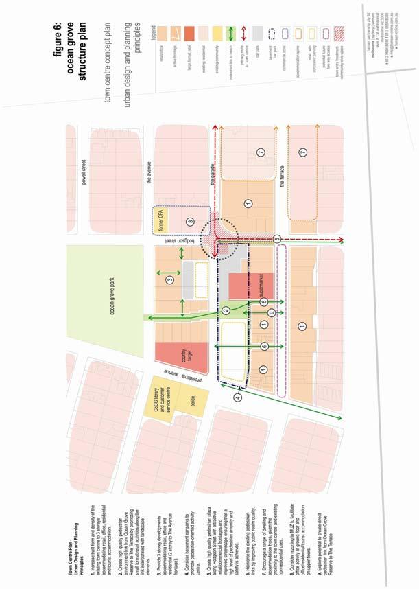
36 A-27
37 o o o o o Locate restricted retail and industrial uses that can demonstrate a benefit from a main road location along the Grubb Road frontage with more traditional industrial and commercial uses to the rear; Provision of appropriate road, pedestrian and cyclist connections to the existing industrial precinct and to Grubb Road; Avoid vehicle connections between the industrial area and residential or other land use activities that might occur on abutting land, but provide for pedestrian and cyclist connections in those directions; Limit the number of entry points to the industrial estate from Grubb Road with access to businesses to be via a service road; Provide an appropriate 10-15m wide landscape buffer between industrial and residential areas and other sensitive uses that could be used as a pedestrian/cycle access if a connection can achieved with either Coolamon Close/Drive or the existing Kingston Downs estate to the east. Include provision for a 1.0ha site for a zoned electricity substation within the expanded industrial precinct. Apply an Industrial 3 Zone and a Development Plan Overlay to the expanded industrial-restricted retail precinct to guide subdivision, Grubb Road and residential interfaces, setback and landscaping, vehicular circulation and access, utility installations etc Rural Areas The Bellarine Peninsula is a predominantly rural area, with distinctly defined towns. Retention of this land use pattern is a fundamental tenet of Council s Urban Growth and the Rural Land Use Strategies. The definition of settlement boundaries for existing towns is a valuable tool to contain urban development and growth and ensure that rural land not included in the proposed future urban area will be retained for rural purposes. Ocean Grove is bound by rural land to the north and east, dissected by a number of road connections to Ocean Grove, Geelong and other towns within the Bellarine Peninsula. The land between the Structure Plan Settlement Boundary and long term boundary is to remain rural until such time as the land is needed to be rezoned for the long term expansion of the town. The existing rural operations in these areas will not be impacted upon as there is a considerable time frame before such land would be considered for rezoning. In the meantime, rural related uses may continue and other temporary uses may establish, on the proviso that the long term growth is not unreasonably jeopardised. Established operations such as Oakdene have an ability to expand their operations (i.e to include conference facilities) where sited in a manner which consolidates or clusters non-production activities in a manner which does not prejudice future town growth opportunities. For areas outside the Settlement Boundaries, other than those areas of high environmental significance, opportunities exist for small scale farm based tourism activities including B&B s, group accommodation cabins, artist studios, food and wine production amongst more traditional farming pursuits. Suitability of non-farming activities will depend on issues such as current policy and zoning requirements, environmental impacts and impacts on existing rural production.. In accordance with State and Local Planning policies and strategies, no provision is made for rural residential development. Rural Area - Principles To ensure the preservation of the surrounding rural landscape and setting of Ocean Grove coupled with its use primarily for rural purposes. To ensure that those areas currently zoned Rural Zone (RUZ) earmarked for long term expansion of the town do not include new uses that will jeopardise future expansion of the town. To provide for other activities of a non farming nature in the rural areas outside the Settlement Boundaries provided they meet relevant policy, zone and overlay provisions. To ensure sustainable farming practices are retained on the land surrounding the town and recognise the right to farm. A-28
38 Rural Area - Directions Retain existing Rural Zones outside both of the Settlement Boundaries and, in the case of the rural land between the two Boundaries, only rezone to an alternative zone once deemed necessary to achieve the outcomes of the Structure Plan. Ensure any land use activities within Rural Zones retain an agricultural focus and preserve the rural, environmental and landscape qualities of the land; Ensure any land use activities within Rural Zones north of the Ocean Grove Nature Reserve and east of Grubb Road do not compromise opportunities for longer term urban growth beyond the time frame of this Structure Plan; Support the future expansion of farm-rural based tourism activities at Oakdene including limited conference facilities etc in a manner which responds to the rural character and setting and does not impact upon future town growth opportunities; Support the establishment of small scale rural based tourism activities including B&B s, group accommodation cabins, artist studios, food and wine production in a manner which responds to the rural character and setting and does not impact upon the environment and existing rural production. A-29
39 PART B IMPLEMENTATION AND REVIEW 1 Implementation of the Ocean Grove Structure Plan Implementation of the Structure Plan directions is to be achieved through a variety of means, primarily through statutory implementation within the Greater Geelong Planning Scheme to guide development on private land (via the rezoning and permit application process), undertaking further strategic work (to fill gaps identified through this Structure Plan review process but outside the capacity and scope of this Structure Plan) and by undertaking works (either by Council or other agencies). The following Implementation Table summarises the process of implementing the major directions over the next 5 years and the important agency stakeholders involved in undertaking or supporting those actions. Implementation Plan Using policy and the exercise of discretion Applying Zones and Overlays Include the Structure Plan within the Greater Geelong Planning Scheme as a Reference or Incorporated Document. Rezone land as identified in the Structure Plan to residential in stages so as not to exceed a year lot supply. Rezone land within the designated north-east growth area consistent with the directions of the Structure Plan including: Application of an Incorporated Plan Overlay (IPO) for the entire north-east residential corridor area. The Plan will include staging of land release for residential, activity centre, primary school and sports fields and industrial/restricted retail areas dependent upon population growth. Apply a Development Plan Overlay (DPO) to those areas in the north-east residential corridor that are within the same ownership or being developed in major stages. Apply a Development Contributions Plan Overlay (DCPO) to north-east residential corridor area which includes provision for: Establishment of links between the development area and Kingston Park; Local community facilities required to accommodate the needs of the future population on and off the site; Road works required to Grubb Road and Banks Road as a consequence of development; Pedestrian and cyclist links required to connect and integrate the area into the wider Ocean Grove access network; and Downstream stormwater management systems as well as open space and community infrastructure requirements; Bus stop infrastructure. Application of an Industrial 3 zone to any expansion of the Grubb Road Industrial Estate. Apply a Development Plan Overlay (DPO) to the industrial-restricted retail precinct. B-1
40 Rezone the Rural Living zoned estate on the north-west corner of Banks and Shell Roads to a Residential Zone (with a Development Plan Overlay) after the preparation of an Outline Development Plan. Rezone land on the existing Residential 1 zone parcel on the south-east corner of Shell and Grubb Road to Public Park and Recreation Zone. Amend existing Significant Landscape Overlay 7 provisions as per background report. Extend the Business 1 zone over land bounded by The Avenue, The Parade, Presidents Avenue and Hodgson Street. Apply a Mixed Use zone over the former CFA depot (south-east corner The Avenue and Hodgson Street) and land to the immediate south. Implement Coastal Spaces Landscape Assessment Study recommendations relating to the application of the Significant Landscape Overlay excluding areas west of Banks Road within the north-east growth corridor. Apply a Salinity Management Overlay to identified salinity discharge areas. Recommended further strategic work Prepare detailed streetscape-design plans for: Town centre growth area and connections; The Hodgson -The Parade entry into the Town centre and carpark; The Parade - Orton Street route; Grubb Road and Tuckfield Street (between Bellarine Highway and The Terrace); Shell Road; The Terrace (Tuckfield Hodgson); Street linkages between the beach and Town Centre. Review the Residential Character Study 2001 as it applies to Ocean Grove including an examination of vegetation significance, existing overlays and the Environmental Rural Zone to determine the most appropriate overlay controls to provide appropriate urban design and landscape outcomes. Establish a Car Parking Precinct Plan for the Town Centre. Other City of Greater Geelong Actions Investigate opportunities to improve community and visitor utilisation of the reserve located to the east of the intersection of The Parade and Tuckfield Street. Prepare a Street Tree Planting Strategy. Consider disposing of the small park (adjacent to south-east corner of The Parade and Hodgson Street) and the nearby Council carpark off The Terrace to provide a consolidated site for retail development with carparking. Provide an additional playground within the Kingston Downs Estate Provide a connection to the Collendina Reserve off Bonnyvale Road Undertake road network improvements including signage, intersection treatment for Presidents Avenue-Orton Street, widening shoulders within The Terrace, and extending Tuckfield to The Terrace/Emperor Drive. Cont d over B-2
41 Other City of Greater Geelong Actions (cont d) Support the development of a round town pedestrian and cycle link with the provision of appropriate connections and infrastructure within Council controlled roads and reserves. Undertake further social infrastructure analysis related to key service provision and need. Key Agency relationships A number of directions require the support of key agencies and/or Council support for the work of key agencies including: Department of Infrastructure development of a local bus service Barwon Water coordinated provision of sewerage and water supply infrastructure Powercor undergrounding of overhead powerlines within vicinity of Town Centre and along Grubb Road, supply of services to future growth areas VicRoads duplication of Grubb Road and support for streetscape, signage and other urban design improvements along major traffic routes Barwon Coast ongoing improvements to foreshore areas and implementation support for round town pedestrian/cycle link Parks Victoria ongoing improvements to key park and wetland areas and implementation support for round town pedestrian/cycle link Bellarine Community Health on going support and expansion of social and community health and support infrastructure Departments of Victorian Communities, Human Services and Regional Development as above Geelong Otway Tourism with Bellarine Peninsula Tourism support for tourism and signage initiatives 2 Review of Structure Plan The take-up of land and redevelopment within Ocean Grove needs to be regularly monitored and it is appropriate that a basic review of development and lot supply within the township be undertaken every 5 years. If such review reveals that the existing lot supply has fallen to a rate of less than 10 years, (using accepted lot supply analysis criteria) a full review of the Structure Plan should be undertaken. This review would need to examine whether further growth of the town is appropriate and, if so, provide directions for growth and community needs, and if so provide directions for growth and community needs and determine the appropriateness of the alignment of the Long Term Settlement Boundary. The review will also investigate the land between the Settlement Boundary and the Long Term Settlement Boundary and assist in establishing an approximate timeframe of remaining a rural zone or potentially being rezoned. B-3
42 PART C BACKGROUND REPORT 3 Introduction The development and planning of Ocean Grove has to date been guided by previous Structure Plans adopted in 1993 and 1979 in addition to State and Local Planning Policies regarding broad urban growth and coastal policies, previously administered by the Shire of Bellarine and the Geelong Regional Commission, and more recently the City of Greater Geelong. More recently State Government Policy documents and numerous Council reports and studies have provided guidance on issues surrounding the future growth of the town in context with Geelong and the Bellarine Peninsula. This report examines the demographic profile of the town and future population projections, urban growth areas, physical and social infrastructure provision, housing supply and diversity, environmental and open space considerations, economic development concerning primarily retail and industrial floorspace and rural land issues. Consultation has occurred with an extensive number of external agencies, Council units and community business and resident groups to obtain background information and issues regarding the study area. Additional comment through the public exhibition process also contributed to background and supporting data. These comments have assisted in highlighting the key issues and opportunities for Ocean Grove and resulted in the drafting of various recommendations contained in the report. Information obtained from the Background Report provides a basis for the key directions in the Structure Plan. A background policy review is essential to appreciate and understand the study area and to develop ideas and strategies for accommodating future growth. The role of the Structure Plan is to identify the key strategic planning issues and opportunities facing the town and articulate the preferred future directions including the location of settlement boundaries, future residential and commercial growth and future community service provision, as well as identifying appropriate planning controls. The following key outcomes have been identified from the background review of existing policy framework and documents, these include: The town is identified as a growth node within State and Local planning documents; The town has the potential to increase to a population of 21,184 by 2020; The total population has the potential to increase up to 25,000-30,000 beyond 2020 should additional residential land to the north of Ocean Grove Nature Reserve be developed; The majority of the population growth could be accommodated within a north-east residential corridor; Limited population growth could be accommodated to the north-west of the town adjacent to Wallington Road; The town centre has the opportunity to accommodate increased intensity of development and an increased built form subject to neighbourhood character considerations; Additional industrial land is required to be set aside to accommodate the staged release of land as the population increases; An additional neighbourhood activity centre along Grubb Road is required to serve the needs of the future population to the north of the town; Additional opportunities for open space and recreational activities will be needed; Improved pedestrian and cycling links need to be provided throughout the town and new subdivisions; An additional primary school will be required to accommodate the future population growth to the north of the town. 3.1 Background C-1
43 The City of Greater Geelong engaged Hansen Partnership Pty Ltd in 2006 to prepare the Ocean Grove Structure Plan Substantial background information regarding the study area and community consultation had been undertaken prior to the commencement of the Structure Plan. This primarily included the Bellarine Peninsula Strategic Plan (October 2005) which included various community workshops and assessment of existing community services. For these reasons a more direct approach was taken with the preparation of the Structure Plan. The methodology of the preparation of the Structure Plan includes considering the policy context of State Planning Policy documents, City of Greater Geelong reports, ABS data and anecdotal information from external agencies, business and resident groups, primary land owners and the community. Workshop sessions were held with Council departments, external agencies including Vic Roads, Barwon Health, Barwon Water and emergency service providers etc. These provided an overview of the issues particular to their areas of expertise and influence. Stakeholder Input A number of workshops were undertaken with key groups to obtain background information relating to Ocean Grove. These included: Council officers; State and local government agencies; Community groups; Business association; and Major land owners. These workshops were useful in developing an overview of the issues surrounding Ocean Grove. Additional discussions also took place with tourist organisations and operators to establish more explicit tourism directions. The comments can be summarised as follows: Need to balance growth role with local requirements and aspirations; Direction and density of growth; Type of development - where consolidation can occur and the location for medium density housing; Coastal theme for housing and the town centre; Location of the secondary school and regional vs. local facilities including sports facilities; Access needs of different user groups especially in relation to the elderly, footpath provision and bike path provision; Environmental sensitivities a key concern in growth especially drainage, maintaining an agricultural edge and the sensitive environmental areas to the south, east and west; The importance of tourism to the local economy and future of Ocean Grove; Role of the Shell Road Shopping Centre (Market Place) versus the existing town centre and where the retail heart should be in the future; and Traffic issues future main street and detailed issues with car movement and parking in the town centres. 3.2 Location C-2
44 Ocean Grove is located on the southern coast of the Bellarine Peninsula and is the largest of nine coastal settlements of various sizes. The town is located approximately 20km from Geelong on the Bellarine Highway. The primary entryway to the town is from Geelong via the Queenscliff Road and then Grubb Road from the north. This route is the primary roadway through the town, via the town centre and links to Barwon Heads to the west. The secondary entryways are via Wallington Road from the west and Shell Road from the east. Figure 1 below shows the location of Ocean Grove within the region. Locally the town is constrained by natural features to the south, west and east. The southern boundary is formed by the coast with locally significant vegetation and Bass Straight. To the west is the Barwon River and Barwon Heads beyond; and to the east are Lake Victoria wetlands. The town has limited constraints to the north where it abuts rural land and the Ocean Grove Nature Reserve. The topography is gently undulating in the northern areas to steeply sloping within the town, closer to the foreshore and the natural dunes formation underlying. There are limited views to all of these features but some clear sea views centrally from the corner of Tuckfield Road and The Parade. Zoning in and around the town reflects the natural features and illustrates that the area where growth may be accommodated is to the north. Beyond the existing residential areas the land to the north and east are zoned Rural (RUZ). The primary Residential 1 (RZ1) area is located south of Shell Road at typical suburban densities. To the north of Shell Road there are a range of urban edge treatments which include three Low Density Residential Zones (LDRZ), a Rural Living Zone (RLZ) and a Special Use Zone (SUZ) for the proposed Goandra Estate. Also at the town edge to the east between Shell Road and Bonnyvale Road another Low Density Residential Zone forms part of the town edge. Between Grubb Road and Banks Road evidence of recent growth can be seen in the new neighbourhood shopping centre, zoned Business 1 Zone (B1Z), and the industrial area on Grubb Road. 3.3 Role of the Town The town has a dual role as a coastal town and a tourist destination and contributes to a unique collection of small towns in the Bellarine Peninsula. Ocean Grove s current role and its growth trend are clearly illustrated in its population trends. The total residents in 2001 were 10,055 people. Between 1991 and 2001 the population grew 18% with official estimates anticipating that the town will increase to 13,594 residents by Importantly the role of the town as a tourist destination is illustrated by its population growth in peak times to 26,121 residents over the summer months. 3.4 History The majority of the history of Ocean Grove is sourced from the study titled: The Pleasure Grounds of the Barwon Coast: A History, Dr David Rowe Authentic Heritage Services Pty Ltd This report includes references to the original habitants and William Buckley, European explorers including Wedge Exploration in 1835, Wills s survey of the mouth of the Barwon in 1855, the development of Ocean Grove, establishment of Ocean Park Reserve and the growth of coastal recreation in the 19 th Century. Until the latter 18 th century, the Barwon Coast area, as part of the southern coast of New South Wales (as Victoria was then called) was unknown to explorers and settlers from the Northern Hemisphere. Yet, the area was the land of the indigenous Australians and particularly the Wathaurong. The Wathaurong Aborigines consisted of several different clans whose territory stretched from Bass Strait to north of Beaufort and west to Lake Bolac (Figure 1.01). These different clans of the Wathaurong had access to the Bream Creek area, including Barwon Heads. With plentiful shellfish and fish, areas including the Barwon Heads Park and the Barwon Heads Village Park, were important sites to the Aborigines. C-3
.")
45 Map 2 - Locality Plan The first European to set eyes upon the Ocean Grove and Barwon Heads area was William Buckley in A convict who had escaped from the settlement at Sorrento, Buckley trekked from Swan Island to Spring Creek (near Torquay). He was discovered by the Aborigines at Maamart, a swamp west of Barwon Heads and adopted into the tribe with whom he lived for the next thirty years. Buckley s travels along the Barwon coastline are now acknowledged, with the reserve spanning from Ocean Grove to Point Lonsdale called Buckley Park. The caves on the coast nearby Point Lonsdale are also named after the wild white man. In 1854, William Bonsey bought the land upon which Ocean Grove is now situated, which consisted of 629 acres. A small community of fishermen and farmers formed the population of the Newington and Ocean Grove areas from the 1860s and 1870s. Around this time a jetty was constructed at the end of Guthridge Street (see Fig. 3.02), and ten or twelve fishing boats operated from this location for the next 50 years. A small weatherboard shed was also built at the end of the jetty. By 1879, the jetty was named after the Blackwells, an early fishing family, and was met by a road, now known as Guthridge Street. In 1887, the Ocean Grove area was subdivided as a unique development based on the precepts of the Methodist Episcopal Church. Auctioned by the estate agents Grigg and Kimberley (Fig. 1.03), the Ocean Grove township was formed according to the ideals espoused by the American Methodist clergy, who came to Victoria and conducted tent missions. A consortium of Victoria s Wesleyan Methodist Church clergy and businessmen were persuaded to support the Americans plan for establishing a summer settlement around a camp meeting site similar to the Ocean Grove settlement in New Jersey, U.S.A. About 2,500 blocks of land were offered for sale, with roads and streets named after Victorian Methodist ministers or places associated with Methodism. Like the covenant imposed upon the settlement in New Jersey, alcoholic, intoxicating, spiritous or venerous liquors were prohibited from sale and manufacture in the proposed Ocean Grove Methodist resort town. A Coffee Palace was also constructed as part of the settlement, although it was part of a proprietary limited company and not completely controlled by the Methodist consortium. The onset of the depression of the 1890s witnessed the end of a truly Methodist-inspired settlement at Ocean Grove, as the clergy and businessmen who had invested in the venture suffered in the financial collapse at the time. However the land subdivision and infrastructure established by the Grigg and Kimberley plan remains to the present day. C-4
46 4 State and Regional Planning Policy Framework 4.1 Department of Sustainability and Environment Coastal Spaces (April 2006) The Victoria s Coastal Spaces Initiative has been progressed to help local governments implement the Victorian Coastal Strategy 2002 and manage development pressures in coastal towns beyond metropolitan Melbourne. Ocean Grove is classified as a District Town which is defined as a town with a large and diverse population base, provides access to a wide variety of services, contains a dominant business district with a moderate employment base and is a popular summer destination along the coast. Ocean Grove is also recognised as having High Growth Capacity and can accommodate large scale residential growth within and beyond current zoned urban limits. Other surrounding townships also classified as accommodating high growth include Clifton Springs/Drysdale and Torquay. The document sets out the need for settlement boundaries to be established to protect the fragile coastal environments and landscapes. These are to be established from the undertaking of structure plans and/or urban design frameworks that then can be incorporated into the planning scheme. Links to the Coastal Spaces Landscape Assessment Study State Overview Report are also drawn with the importance of maintaining the landscape character and landscape significance along the Victorian Coast Coastal Spaces Landscape Assessment Study State Overview Report 2006 The Coastal Spaces Landscape Assessment Study provides a thorough assessment of landscape characteristics and identification of visually significant landscape, focusing on the coastal areas of Gippsland (Bass Coast to the NSW border), the Bellarine Peninsula and the coast west of Warrnambool to the South Australian border. The project identifies and maps individual landscape characteristics within these coastal regions, identifies significant landscapes and provides an implementation framework to assist local government and other agencies in managing development impacts within coastal landscapes. The study identifies a number of Landscape Character Types and Areas for the Bellarine Peninsula. Ocean Grove adjoins or is located in the following Landscape Character Areas: Landscape Character 2.1 Lake Connewarre Flats This area is mostly flat and is seasonally inundated or under large lakes. The area extends from Breamlea to Barwon Heads and to Point Henry. The area extends partially into Ocean Grove adjacent to the Barwon River estuary and along Wallington Road to the north and west of an existing rural residential subdivision an area which is highly visible viewed from Barwon Heads and users of the waterway. Landscape Character Area 2.2: Lonsdale Lakes A small, very flat and seasonally inundated landscape is found between Point Lonsdale and Ocean Grove in the Swan Bay catchment. The Character Area is dominated by waterbodies and wetlands, including Lake Victoria, and is mostly pastoral in the remainder. High, vegetated sand dunes at the coastal edge and prominent slopes inland are important topographic features that provide a backdrop to open views. Part of this area extends into the town west of Banks Road in an area nominated for future urban growth. Landscape Character Area 4.1: Bellarine Hill (Murradoc Hill) This hilly to gently undulating Character Area covers much of the central and northern Bellarine Peninsula. As the major topographic feature of the peninsula, this Character Area forms a significant landscape backdrop to many towns and viewing locations, and offers expansive outviews. While it is largely open and C-5
")
47 Source: Coastal Spaces Landscape Assessment Study State Overview Report (September 2006) C-6
48 cleared, cultural vegetation patterns of windbreaks, vineyards and established exotic trees around homesteads are important landscape features. The findings of the study include the application of a number of Significant Landscape Overlays being: Lake Connewarre Escarpment (affecting a small area to the north-west of the town; and Lake Victoria and Yarram Creek (affecting a small area west of Banks Road with urban development opportunity) The application of the overlays as prepared will have some implications for the extent and treatment of urban development along and within these interfaces Victorian Coastal Strategy (2002) The Victorian Coastal Strategy 2002 (VCS) is based on a triple bottom line approach in relation to sustainable development that achieves the conservation and management of the Victorian Coast for the present and future generations. This Strategy outlines the Victorian Government s overall vision for coastal management which is primarily to focus urban development within established settlements. It recognises that coastal settlements change as community aspirations are realised. Some settlements will expand significantly as new urban housing is developed, while others are likely to remain small and serve as recreational-based, often seasonal settlements. The report specifically addresses issues relevant to this matter including: the need to focus urban development along the coast within established settlements; the need to promote and protect the values of scenic coastal roads; and the need to improve design outcomes for buildings and structures in foreshore and coastal areas. The report elaborates on what is suitable or an appropriate scale and intensity of development on the coast. It recommends that development occur in accordance with the ecologically sustainable development principles for coastal planning and management outlined in the Strategy Great Ocean Road Strategy (2004) This strategy is a long term land use and transport strategy for managing and integrating development in the region to prepare for future growth. Under four main direction headings the strategy addresses issues of conservation of landscapes and the environment, managing the growth of towns, improving the management and access of transport, and encouraging sustainable tourism Siting and Design Guidelines for Structures on the Victorian Coast (1998) These guidelines seek to define and raise awareness of the issues which should be considered in the siting, design and construction of new structures in coastal areas. The strategy also provides guidelines for development on both private and public land and identifies sensitive design issues which need to be considered for new development along the coastal areas of Victoria. The guidelines are broken up into three key headings as follows; functional guidelines which deal with utilitarian aspects of the development and seek to ensure the efficient use of the limited resources; cultural aesthetic guidelines address cultural issues and the appearance of structures and the way these relate physically and visually to the surroundings; and ecological guidelines address the impact of development on coastal ecosystem. C-7
49 4.1.6 Melbourne 2030 (2002) Melbourne 2030 is a 30 year plan to manage growth and change across metropolitan Melbourne and the surrounding region. It emphasises the city s interdependence with regional Victoria, to provide maximum benefit to the whole State. Whilst the plan focuses primarily on the metropolitan Melbourne urban area it also deals more broadly with the wider region where, increasingly, development is linked to and affected by metropolitan Melbourne in terms of commuting, business and recreation. Hence, Melbourne 2030 also gives considerable attention to the regional centre of Geelong. Of particular importance is Direction 3 Networks with the regional cities which consist of the following policies: Promote the growth of regional cities and key towns on regional transport corridors as part of a networked cities model Control development in rural areas to protect agriculture and avoid inappropriate rural residential development Urban Development Program Annual Report (2006) The DSE Urban Development Program annual report on lot supply and demand for Melbourne and Geelong identifies that the Geelong Region has, in aggregate, sufficient stock of residential broad hectare land to satisfy demand for more than 25 years. Of this stock only around 3-4 years' supply is currently zoned for residential purposes". The report notes that current supplies of zoned residential land are considered extremely low in the Geelong Region and appear to be impacting on the development industry's ability to deliver sufficient broad hectare stock to the market both in Geelong Township and the Bellarine Peninsula and Torquay areas. Immediate effort should be focussed on facilitating strategic planning work that will lead to an increase in zoned broad hectare residential land supply. The report indicates in Ocean Grove a take up of broad hectare residential zoned land generally within the next 3 5 years and the area between Grubb and Banks Roads north of Shell Road. 4.2 Regional Strategic Documents G21 The Geelong Region Plan (2006) The G21 Geelong Region Plan (draft) sets out directions and policies to guide future planning and development in the G21 Region over the next 50 years up to The report makes a number of observations of interest to Ocean Grove including: On average Ocean Grove experiences predominantly average levels of advantage, disadvantages, education, occupation, and economic resources. It does recognise that above average levels of all indexes are recorded in one small northern section of the community. Ocean Grove has areas fronting the coast that are below the 1,000 average for economic resources however these pockets of relative disadvantage may be the local community in the largely seasonal community. Ocean Grove has no significant (below 900) levels of disadvantage for all indexes. Ocean Grove is identified as a town to experience significant growth. Consultation undertaken for the study indicated that there was a need to provide an appropriate level of services and facilities in rapidly growing locations such as Ocean Grove. The study acknowledged that towns such as Ocean Grove often lacked services of a higher order because of the large numbers of vacant dwellings. Key supporting actions include: Ensure average 15 years residential land supply (10 years zoned), 15lots/ha densities, support urban infill C-8
50 Minimise outward urban expansion so as to protect agricultural land, non urban breaks Encouraging higher density coastal development whilst promoting and maintaining coastal character Water sensitive urban development, energy efficient design and recycling/reuse of water in industrial/commercial operations Creation of safe, well designed and sustainable communities with priority to cycling and walking Upgrade transport infrastructure including increasing public transport usage through strategies such as the G21 Public Transport Policy Town centres to be the community focal point for towns Provisions of employment land including industrial zoned land Bellarine Peninsula Strategic Plan The Bellarine Peninsula Strategic Plan is a broad community plan for the Bellarine Peninsula developed in recognition of significant growth pressures within the Peninsula characteristic of the sea change phenomena. The Plan includes a visions and actions for the Bellarine and each of its towns. The report includes a Community Service Plan and directions for tourism and rural areas. The community vision for Ocean Grove in the year 2016 is: Ocean Grove is a major township offering a range of lifestyles, culture and natural environmental assets. While it is a designated growth town, Ocean Grove will retain its coastal urban character and protect and promote the attributes of the natural environment. As an integral part of the Bellarine Peninsula, Ocean Grove shares the attributes of other townships, the rural sector and our natural environment. Active community participation is encouraged to maintain all these linkages and attributes. The Ocean Grove township objectives have been established from public consultation sessions held by a local community group to oversee the process. The objectives are established from the key actions seen necessary to achieve the Community Vision. The strategies and actions for Ocean Grove include: Ensure ongoing environmental protection of foreshore as Ocean Grove s most important natural asset and enhance the optimal use of beach and river for a diverse range of activities by linking the river and coast with a pedestrian/bike track; Increase opportunities for local entertainment and cultural exchange by supporting provision of a cinema and multi use of Shell Road Reserve ; Provide a built environment which enhances the quality of living whilst respecting our local natural environmental assets by maintaining the rural/green separation of towns, promoting sustainable development and encouraging growth inland and completing a Structure Plan; Recognise the contribution Older Persons make to our community and provide activities and services to enhance their quality of life by supporting co-location of BPCH and OGNC to Shell Road; Provide a better living environment through an improved public transport system on Bellarine Peninsula and enhanced vehicle traffic movement through and around Ocean Grove; including implementation of traffic study findings; Provide access to a diverse range of residential activities (active and passive) which are appropriate to the needs of our demographics by supporting development of Shell Road reserve and implementing the Recreation and Leisure Needs study recommendations; Recognise Ocean Grove as both a local town centre and a major retail hub of the Bellarine Peninsula and develop retail/office space to suite the needs of Ocean Grove residents and visitors by providing for diverse and innovative retail development; Encourage the growth and diversity of compatible adjacent rural activities and their linkages to the Ocean Grove Township; Provide accessibility for Ocean Grove residents to the full range of Social Services required to support projected demographics; C-9
51 Enhance Ocean Grove as a tourist destination and recognise the positive attributes that visitors bring to our town by encouraging eco-tourism accommodation; and Provide and enhance opportunities for our local youth and promote their contribution to the community by providing for activities and entertainment and improved linkages. 5 City of Greater Geelong Statutory and Strategic Planning Policy Framework 3.1 City of Greater Geelong - Statutory Framework The State section of the Planning Scheme includes a number of general policies relating to: Melbourne 2030 and links with regional centres; Settlement; Environment; Housing; Economic Development and Employment; Infrastructure; and Design and Built form. Council s Municipal Strategic Statement (MSS) includes a number of references to future residential growth and Ocean Grove. The MSS and local policies will soon be revised however the Structure Plan has been written with these changes in mind. The policies outlined below are those current at the time this Structure Plan has been written. Clause Geelong in perspective The City of Greater Geelong is the second largest municipality in Victoria and comprises urban land, rural hinterland and coastal areas, capturing a total area of approximately 1,240 square Kilometres? Ocean Grove is a coastal township and is part of the Bellarine Peninsula. The town has experienced significant growth with the township population doubling in growth between 1981 and Similarly to other townships within the Bellarine Peninsula, Ocean Grove households tend to include families with children. Clause Urban growth Accordingly the strategies recommend future urban growth in Ocean Grove should be channelled to the north of Shell Road and east of Grubb Road. The Council also recognises that there are numerous sites within the township that can provide opportunity for growth. Council proposes to undertake a Structure Plan for the coastal town during Clause Rural residential (living) development The MSS identifies the demand for rural residential development as people are predominantly seeking a rural living environment. Such properties vary between 1 and 3 hectares in size. A number of nodes for such lot sizes are identified within the Bellarine Peninsula, including Wallington which lies directly to the north-west of Ocean Grove and therefore has some correlation to the Structure Plan. It is noted that these areas may continue to be developed but not expanded. Clause Coastal areas This Clause identifies pressures on the coastal environment caused from urban development and seasonal tourism. These issues have an impact on the ecosystems of the coastal environment. It makes references to C-10
52 protecting key coastal townships including Ocean Grove. One of the key objectives is to focus development around existing settlements to prevent linear sprawl along the coast. Clause Ocean Grove This Clause gives an overview of Ocean Grove including objectives with the supporting strategies. These relate to residential opportunities, retailing and commercial expansion, service business and industry, community facilities, recreational opportunities, tourism and transport network. Ocean Grove is located approximately 25 kilometres from centre of urban Geelong and is the principal coastal township. Ocean Grove's service centre role will continue to grow in line with its current population. The Council's MSS states that the estimated residential population will reach 15,000 persons by The MSS defines clear growth boundaries to the south, east and west and suggests that the only potential for future growth is to the north east, away from the coast. Other clauses within the MSS The MSS also includes a number of other key headings that provide general guidance which specifically relate to Ocean Grove. The general headings include Environmental Management, Protection of Catchments and Waterways, Flora and Fauna, Open Space, Cultural Heritage, Energy Efficiency, Housing, Economic Development, Commercial and Retail Centres, Industry, Tourism, Agriculture and Rural Land, Transport and Design and Built Form. Comments regarding Barwon Heads note that Ocean Grove is the closest major centre with facilities that service the populations of nearby townships. Clause 22 Local Planning Policies There are no Local Policies within the City of Greater Geelong Planning Scheme specific to Ocean Grove. A number of municipal wide policies relating to low density development and industrial development are included that have limited implications to future growth of Ocean Grove. Zones Ocean Grove is predominantly residential with a town centre, second activity centre and industrial area located to the north. The following outlines the various zones that existing within the town. Residential 1 Zone The majority of land within the town is zoned Residential 1, extending from the well established residential areas of Ocean Grove in the west through to Collendina in the east and partly to the north in Kingston Downs. Such land provides the accommodation for the vast majority of the population. Low Density Residential Zone sizeable groupings of such land is generally located on the fringe areas of the town. These exist in four separate groupings of varying sizes. This zoning was previously applied to land to provide low-density residential land on lots that are not provided with reticulated sewerage and can treat and retain all wastewater. The lots are generally not less than 0.4ha in size and provide larger housing lots with existing vegetation. Special Use Zone (Schedule 8) A substantial tract of land exists to the north of the town called Goandra land which has had recent planning approval for 170 lots with a minimum lot size of 1000 square metres. The site is to be developed in such a manner to protect the environmental significance of the subdivision through the on going management of the Bellarine Yellow Gums and other significant vegetation. Rural Living Zone Three areas are located on the periphery and contain larger lots than the Low Density Residential Land and Special Use Zoned land. The zone has a rural focus enabling land to be used for rural purpose, without affecting the amenity of surrounding land uses whilst maintaining the natural features and values of the area. Minimum lot sizes are 1 hectare. C-11
53 Rural Zone The majority of land surrounding the town is zoned Rural. Environmental Rural Zone located adjacent to The Esplanade, Buckley Park and sensitive foreshore primary coastal dunes this zone and schedule seek to protect the dune and vegetation from urban encroachment, over use and development. Business 1 Zone This land is located within the town centre and also within the Ocean Grove Market Place. Such land accommodates the primary retail and business uses of the town. Business 2 Zone This land is located to the north of the town centre and accommodates a range of existing offices and medical practices that have evolved over time. Business 4 Zone This parcel of land is located to the north of the town adjacent to the industrial precinct. The purpose of the zone is to encourage a mix of bulky goods retailing, manufacturing and associated businesses. The minimum leasable floor area in the schedule is 1,000 square metres. Industrial 1 Zone This parcel of land is also located to the north of the town along the primary route into town. The purpose of this zone is to allow for manufacturing and the storage and distribution of goods. There are no minimum floor areas specified in the Schedule to the Zone. Overlays Design and Development Overlay 11 These small parcels of land are located along The Esplanade and Orton Street at the southern end of the town. The objective of the overlay is to provide for the conservation and enhancement of the coastal dune system by ensuring development is compatible with the local environment. Design and Development Overlay 14 The majority of residential zoned land is covered by this overlay. The area extends from the well established section of Ocean Grove through to Collendina in the east. This land provides the accommodation for the vast majority of the population. The overlay applies to dwellings over 7.5 metres and it seeks to ensure that new dwellings and extensions to existing dwellings are compatible with the existing scale and character of adjoining dwellings. It further requires that the height and visual bulk of dwellings are acceptable in the neighbourhood setting. Heritage Overlay Heritage properties are dispersed throughout the town and consist of significant dwellings, the Ocean Grove Primary School, former St Peter s Church of England, the Uniting Church, the General Store and stables and outbuildings at Shell Road Bonnyvale. The larger parcels of land noted for their heritage significance include Ingamells Park at The Avenue, which is an area of open space significant as an example of remnant flora of the Bellarine Peninsula and also has important social, cultural and historic associations. Goandra Rielly s Property is of National significance because it contains the best known stand of Bellarine Yellow Gum. The site is also of regional significance due to the occurrence of a further 39 regionally significant plant species. Other sites of significance include The Kingston Residence at 65 Tuckfield Street, Marcus Hill State School and the former Post Office form significance heritage sites in the neighbouring suburb Marcus Hill to the north-east. Land Subject to Inundation Overlay This land is primarily located to the east of the Ocean Grove Town Centre. A smaller parcel of land is affected by the overlay within the town centre along Lake Avenue between Wiltons Road and Blue Waters Drive. Floodway Overlay This overlay covers the Barwon River which is situated to the immediate west of the Ocean Grove Town Centre and includes Lake Connewarre. The Barwon River connects to Bass Straight from Barwon Heads and separates Ocean Grove from that town. Public Acquisition Overlay 6 This land is located to the west of the Ocean Grove Town Centre along sections of Wallington Road. VicRoads has acquired this land as a proposed Category 2 Road. C-12
54 Vegetation Protection Overlay 1 This land is located throughout the Ocean Grove township consists of significant roadsides and linear reserves. The land is primarily located along Grubb Road, Wallington Road and Woodlands Drive. Vegetation Protection Overlay 2 This land is located along Thacker Street between Bellevue Drive to the west and Sylvan Lane to the east. The land is designated as a Vegetation Protection Area and is called Goandra land. This site has had recent planning approval for 170 lots with a minimum lot size of 1000 square metres. The site is to be developed in such a manner to protect the environmental significance of the subdivision through the on going management of the Bellarine Yellow Gums and other significant vegetation. Environmental Significance Overlay 1 This parcel of land is located to the east of the Town Centre and is noted by this overlay as an area of significant flora and fauna habitats and an area of geological and natural interest. Environmental Significance Overlay 2 This overlay comprises the Barwon River, the Begola Wetlands and wetlands within Collendina. The overlay values these areas for their wetlands and associated habitat. Significant Landscape Overlay 6 This overlay applies to land situated on the north east corner of Wallington Road and Thacker Street which falls within a Rural Living Zone. It is a very prominent site at the entrance to Ocean Grove and rises steeply from its Wallington Road frontage. Significant Landscape Overlay 7 This overlay applies to predominantly residential zoned land in close proximity to the Barwon River and Ingamells Bay. The primary purposes of the overlay are to preserve the balance between roof tops and vegetation in long distance views of the town and respect the sharing of views to the ocean and Barwon River. Proposed Wildfire Management Overlay This overlay is currently being proposed to cover the Ocean Grove Nature Reserve including extending across the wider north eastern corner of the properties located off Woodlands Drive. It is also proposed to cover the eastern end of the Buckley Park Foreshore Reserve abutting Point Lonsdale. 3.2 Urban Growth City of Greater Geelong Urban Growth Strategy (1996) The purpose of this strategy is to determine the most suitable areas for the accommodation of urban growth to the year On the basis of existing demand and the take up of land at 15 dwellings per hectare, the strategy indicated that there is 24.1 years of supply left at Ocean Grove and designates the town as a residential growth area. For this reason the strategy recommends that the existing planning zonings remain without further zoning for residential uses. It is noted however that demand in growth has increased in Ocean Grove since 1996 and therefore further zoning for residential uses is necessary to accommodate the future projected population. The strategy indicates that the overriding concerns about future growth at Ocean Grove include the proximity to Lake Victoria given existing drainage problems which have resulted in blue-green algae outbreaks and the ability to stop development from extending north beyond Wallington towards Drysdale/Clifton Springs. The strategy recognises that the most logical boundary to northern expansion is in line with either the northern or southern boundary of the Ocean Grove Wildlife Reserve, however identifies that there are concerns with allowing urban development too close to the Reserve. For this reason the strategy recommends that the existing planning zonings remain without further zoning for residential uses. In this way the zoning itself becomes the effective boundary for future urban development. C-13

55 3.2.2 City of Greater Geelong Ocean Grove Structure Plan (1993) This Structure Plan built on and replaced the previous 1979 Structure Plan. The Plan outlines the recommended residential, rural, commercial and community/recreation development zones for the study area. The estimated residential population as at 1993 was 8,540. The Structure Plan found that potential for growth was limited in most directions except to the north of Shell Road and east of Grubb Road. The Structure Plan indicated that the undulating hills and pleasant and interesting landscape provided the potential for urban development and open space networks. Other sites recognised as redevelopment opportunities were the under utilised caravan park and camping areas. C-14
56 3.2.3 Bellarine Peninsula Land Use and Residential Lot Supply Report (2005) The objective of this report is to determine the future residential lot supply, and to identify any discrepancies between existing land uses, zones and Structure Plans, and/or Urban Design Frameworks, for each of the townships on the Bellarine Peninsula. Ocean Grove is defined in the report as a dormitory town to Geelong, a resort town and a service centre catering to the commercial, residential, recreational and local employment needs of the residential population, surrounding rural hinterland and visitors. The town locality area is approximately 1529 ha. The town total area contained within the Urban Growth Boundary is approximately 1274 ha. The report identified in relation to land use that the larger townships of Bellarine Peninsula such as Ocean Grove, cater for larger residential areas and therefore have the widest variety of land uses. The main use of the town within the urban growth boundary is residential. Further, Ocean Grove is designated by the Urban Growth Strategy (1996) as a residential growth area. Rural land use is the second most common land use found across the town as large areas of rural land appear inside the urban growth boundary. Ocean Grove does not present any noticeable inconsistencies between existing land use, zoning and its approved Structure Plan (1993). Current lot supply figures indicate that there is enough land to cater for future growth in Ocean Grove for approximately 25 years. It is expected that demand for dwellings in Ocean Grove will continue at approximately 143 dwellings per annum at a 10 lot hectare yield. Medium density housing will continue to be encouraged in close proximity to the town centre or major activity area and is currently identified for Ocean Grove in the Ocean Grove Structure Plan (1993) Medium Density Housing Strategy Council has prepared a draft Medium Density Housing Strategy as part of the review of the Municipal Strategic Statement (MSS) and Local Policies. This strategy will identify preferred and non-preferred areas for MDH (nominally 400m radius of an activity centre) and identify a planning policy framework to encourage MDH in preferred locations. MDH within in close proximity of activity centres reduces car dependence and facilities increased levels of walkability. An increased number of people of within the 400m catchment of an activity centre will also contribute to the economic well being of an activity centre Major current Amendments relevant to Ocean Grove Amendment C102 Ocean Grove Country Target This amendment proposed the rezoning of a site at Presidents Avenue and 71 The Parade, Ocean Grove from Residential 1 to Business 1 to allow the development of a discount department store and small specialty shops. The amendment also included the land within a Design and Development Overlay (DDO16) to provide specific planning provisions regarding building design and to remove the Significant Landscape Overlay 7 Ocean Grove Coastal Area from the land. The amendment has been approved by the Minister for Planning. Amendment C60 Future Urban Growth Area, Grubb Road, Ocean Grove This amendment proposes to rezone a 186 hectare property between Grubb Road and Banks Road, north of Kingston Downs and Parks estates, Ocean Grove from a Rural Zone to Residential Zone 1 (178.5ha) and Business 4 (7.5ha) zones. The proposal is incorporated within a concept plan to determine and to define the future residential growth corridor of Ocean Grove. This is an extension to the existing Kingston Downs subdivision and incorporates land currently zoned Residential 1 of approximately 36 hectares. The land subject of this application falls within the area designated in Council s Urban Growth Strategy and Ocean Grove Structure Plan (1993) for future urban growth. Consideration of this application was deferred pending preparation of a new Structure Plan for Ocean Grove. C-15
")
57 Source: Bellarine Peninsula Land Use and Residential Lot Supply Report (2005) C-16
58 3.3 Infrastructure Bellarine Peninsula Strategic Plan Ocean Grove The Plan includes a Community Service Plan which considers social and community needs associated with population growth. Population change In 2001 Ocean Grove had a total resident population of 10,055 people which represents 25.1% of the Bellarine Peninsula. It is estimated that the population increases to approximately 26,121 during peak holiday times. Official estimates anticipate that the population will increase to 13,594 residents in Early Years - In 2001, 22.2% of Ocean Grove population was aged 14 years or under. It is estimated that this will increase by 7.6% in Research identified the need for: improved information for parents; additional child care; improved pedestrian infrastructure; increased flexibility of operating hours and reduced costs for early years services; local playgrounds; and local branches of State Government departments. Youth Ocean Grove has the highest proportion of youth on the Bellarine Peninsula. In 2001 people aged between represented 11.7% of the population. This proportion is expected to increase to 12.5% by Research identified the need for: a committee to organise and manage events for young people; improved information services, including youth drop in centre; employment services; and improved transport across Peninsula and to Geelong. Older Years in 2001 people aged 65+ represented 13.8% of the population and people aged 80+ represented 4.8% of the population. Research identified the need for greater attention given to neighbourhood infrastructure. Indicators of disadvantage In 2001, 26.7% of Ocean Grove households were earning incomes in the lowest income quartile. Further, Centrelink data indicates that high proportions of all Centrelink payments on the Bellarine Peninsula are paid to residents of Ocean Grove. However SEIFA data rates Ocean Grove as an advantaged area based on factors such as income, education, occupation, wealth and living conditions. Community Services Plan Ocean Grove The 5 key recommendations of the Community Service Plan include: Explore option to relocate Ocean Grove Neighbourhood Centre and the Bellarine Community Health Centre to Surfside Centre (Shell Road); Encourage out-posting of services such as health and employment agencies to the redeveloped Surfside Centre; Promote existing sport, recreation and cultural opportunities available in Ocean Grove; Inform private child care providers of CoGG Early Years research findings for Ocean Grove; and Future and strategic planning and rezoning work, including the Kingston and Parks Estate and the Ocean Grove Structure Plan, consider site zoning for neighbourhood facilities. C-17
59 Other infrastructure Ensure social service infrastructure is in place to meet demand of growing population and changing demographics. Provide a multi-purpose entertainment venue including improved access to existing Bellarine Peninsula venues (eg. Potato Shed). Upgrade existing town infrastructure (eg. Water, sewer, stormwater) to meed good ESD principles. Increase accessibility to public transport both within Ocean Grove and on the Bellarine Peninsula as a whole. Increased frequency of public transport and connections to Geelong and other locations within the Bellarine Peninsula. Consideration of a circuit bus, similar to the shuttle bus that operates during summertime; Improve traffic movement and management through and around Ocean Grove. Implement all the recommendations of the Bellarine Peninsula Recreation and Leisure Needs Study 2005, specific to Ocean Grove. The need to improve walkability and connectivity for the community particularly the young, elderly, families with prams and those less mobile and increase the provision of footpaths throughout existing and new residential estates; Bellarine Peninsula Recreation and Leisure Needs Study (2005) This study investigates and quantifies the recreation, open space and leisure needs of the current and future Peninsula communities. The focus of the study is to provide broad direction on future resource allocation to meet the current and anticipated future leisure needs of the Peninsula communities. Overall the study found the provision of open space in Ocean Grove is significant and the area is well serviced by a range of recreational options, ranging from formal sporting clubs, indoor facilities, community centres, library, foreshore, river and conservation areas. However, the report indicated there were distinct gaps in certain categories including Landscape & Amenity, Linear Links and to a lesser extent Informal Parks. Existing sports sites, Ocean Grove Memorial Reserve, Collendina Reserve and Shell Road Reserve are constrained by the fact that they are single oval facilities which limits their flexibility and capacity to cope with growing demand of a range of sports which has lead to over-use issues. Further, there is an inadequate supply of sports sites to cater for growing recreational demand and the significant growth in junior sports participation across a range of activities, in particular cricket, football, soccer and basketball. Some of the key recommendations for Ocean Grove include: Council to develop a multi-purpose indoor heated aquatic centre at Shell Road Reserve. Acquire through developer contributions a 4-5 hectare open space site for the establishment of two multipurpose sports ovals/turf areas north of Shell Road and east of Grubb Road as Kingston Downs Estate expands. Acquire via developer contributions, a corridor of open space along the natural creek line in the Goandra Estate, and provide a pedestrian and cycle connection to the Nature Reserve through the proposed Yellow Gum Reserve. Acquire via developer contributions, a suitable site for an Informal Park, including playground, in Goandra Estate residential development in conjunction with the proposed open space corridor/yellow Gum Reserve. Incorporate a safe pedestrian/cycle link across Grubb Road to the Nature Reserve from the Kingston Downs future residential area, eastward to Bonnyvale Road and to the foreshore, providing a link around the entire town. Related to the above opportunity, provide a shared path along the eastern side of the Barwon River providing connection to the Barwon Coast trail system from Ocean Grove Golf Club. Improve all entrances to Kingston Park reserve through landscape improvements; provide a safe crossing of Shell Road and links to the residential area to the east. C-18
60 Investigate opportunities to improve community use of Begola Wetlands area. Consider selling the elongated reserve with narrow entrance off Emperor Drive and Roditis Drive given it is poorly located and undeveloped. Funds would be directed to the Open Space Reserve Fund for future open space purchases and/or improvements. Provide improved access to Collendina Reserve and improve walkability of Collendina through installation of footpaths and safe road crossings providing improved connections Study of Open Space Networks 2001 The Background Report outlines the demographics and open space provision for the Bellarine and Coastal towns and lists the recommended priorities for action. For Ocean Grove the recommended priorities include: Acquire and develop Linear Linkage sites which allow improved pedestrian and cyclist movement within the town and between Ocean Grove and other towns in the district; Acquire land north-east of Shell Road for the future development of an integrated sub regional site; Following the above acquisition, redevelop sections of Shell Reserve as a substantial cultural reserve with formal and informal garden areas, including walking and cycle paths; Acquire a site north-west of Thacker Street, within the Goandra Estate, as a local park; Develop a pedestrian cycle link around the Ocean Grove Flora and Fauna reserves, south-west through the proposed Goandra Estate to Blue Water Lake, through to the Barwon River and south-east to the Kingston Downs Estate; Support the development of Ingamells Park as an important Landscape and Amenity and Informal Park for community use; and Investigate the development of walking trails to and around Lake Victoria from Ocean Grove and Point Lonsdale. The report provides a context of the study area in terms of future networks, themes and opportunities and outlines actions for the area: Current Situation Small villages are dotted along the foreshore, with an orientation and focus that generally dismisses the hinterland district. Connectivity between the villages is limited, creating a sense of isolation between each settlement. The Peninsula Zone has 36.6 percent of all open space sites in Greater Geelong reflecting the large Conservation and Heritage area of Lake Connewarre and the Foreshore, Beach and Ocean strip surrounding the peninsula Lake Connewarre, together with a series of estuaries, lakes and rivers dominates the hinterland and provides a diverse environmental and ecologically important resource and water based recreation opportunities, eg. canoeing and sailing. Informal Parks and Linear Linkages are the most numerous venues in the Zone. Conservation, Heritage and Habitat sites while less numerous than those above, account for 71% of the total open space area in the Zone. Whilst the numbers of potential open space areas are low, the areas are not and most of these sites comprise large specific sites. Future Networks, Themes and Opportunities Explore opportunities to provide bicycle access between Drysdale and Ocean Grove. Provide for future sports recreation opportunities, in particular to service the growing residential areas of Ocean Grove. In particular there is opportunity to acquire land north-east of Shell Road for the future development of an integrated sub regional site. C-19

61 C-20 Source: Bellarine Peninsula Recreation and Leisure Needs Study (2005)
62 Provide shared bicycle and pedestrian access paths where possible around the foreshore, or via links to the foreshore in areas of poor access or environmental sensitivity. Encourage and facilitate tourist activities that take in the agricultural themes/wineries. Restrict access to sensitive dune areas between Breamlea and Point Lonsdale. Zone Actions (P1) Protect important viewscapes as areas of significant landscape including the Portarlington ridgeline, the western facing hillsides to Lake Connewarre from Wallington Road and the minor ridge that forms the western boundary of Ocean Grove through local policy and/or overlay controls. (P4) Promote a safe bicycle link between Ocean Grove and Drysdale/Clifton Springs preferably through an off road trail either adjacent or within the Road Reservation. (P6) Retain the Council policy of urban containment to protect the rural and coastal landscape. (P8) Promote opportunities for sensitive private recreation facilities that can enhance the experience of these perceived open spaces of the rural landscape (e.g. wineries, host farms, fruit picking, horse riding etc.). (P10) Acquire land north east of Shell Road for the future development of an integrated sub regional site accommodating each of Sports, Informal Park, Landscape and Amenity and Linear and Linkage open space elements. Ocean Grove and Point Lonsdale Sub Zone Actions Acquire and develop Linear Linkage sites, which allow improved pedestrian, and cyclist movement both north-south and east-west through the town. Ensure that safe crossings of Thacker Street and Shell Road are provided at appropriate locations. Acquire and develop Linear Linkage sites which allow improved pedestrian and cyclist movement between Ocean Grove and other towns in the district, including Drysdale to the north, Barwon Heads to the west and Point Lonsdale to the east. Acquire land north east of Shell Road for the future development of an integrated sub regional site accommodating each of Sports, Informal Park, Landscape and Amenity and Linear and Linkage open space elements. Acquire a site north-west of Thacker Street (in the Goandra Estate) as a local park for Informal Park, Landscape Amenity, Conservation and Linear and Linkage open space elements. Redevelop sections of Shell Reserve to complement the existing sporting use as a substantial cultural reserve with formal and informal garden areas including walking and cycle paths. Develop a pedestrian cycle link around the Ocean Grove Flora and Fauna reserves south west through the proposed Goandra Estate to Blue Water Lake and through to the Barwon River and south east to the Kingston Downs Estate. Support the community development of Ocean Grove Park (Ingamells) as an important Landscape and Amenity and Informal Park for community use in accordance with the management plan for this site. Investigate the development of walking trails to and around Lake Victoria to Ocean Grove and Point Lonsdale. In doing so ensure the Coastal Sand Dunes are protected from inappropriate use and development. An additional bike trail that links the current trail along Tuckfield/Grubb Road between the Terrace and Sinclair Street further along Grubb Road to Portarlington Road to the north G21 Integrated Public Transport Strategy The strategy includes a number of outcomes related to improving road and rail infrastructure, freight transport, integrated public transport and improved amenity associated with walking and cycling and alternative transport modes. C-21
63 Actions under public transport include: improving the effectiveness and coverage of public transport related services; and developing land use and spatial planning approaches to facilitate access to transport services. Developing a Regional Public Transport Policy to provide for integration of networks and encourage best practice City of Greater Geelong Transport Strategy (December 2003) The Geelong Transport Strategy provides a transport framework for the City of Greater Geelong and not just Geelong itself. The strategy identifies the following issues for Ocean Grove: poor accessibility to public transport services; potential for a high frequency bus service between Ocean Grove and Geelong; investigation of options for the road traffic capacity constraints of the Barwon Heads Bridge; regional and local traffic conflicts in Ocean Grove (The Terrace and The Parade); and regional and local traffic conflicts on Shell Road. The strategy also had relevant, generic, strategies for the whole municipality, including designing new subdivisions for bus access, pedestrian and cyclist safety, etc Andrew O Brien Draft Ocean Grove Traffic Study 2006 The report outlines some of fundamental traffic and movement conditions within Ocean Grove. Key findings include: The need to establish a clear and functional road hierarchy for the town. The importance of a road hierarchy is to provide a clear statement of the intended function of roads and streets. The report proposes changes to the classifications of a substantial number of roads of varying capacity. Maintain The Parade as the main traffic route through the town rather than The Terrace given: the significant cost to upgrade Terrace; potential for vehicle and pedestrian conflict resulting from potential turning movements of cars from The Terrace into Hodgson; VicRoads does not agree to bear the cost of upgrading the roads; the majority of traffic in the town has a destination and purpose (less than 5% of vehicle trips is through traffic). A short connection between The Parade, The Terrace and Emperor Drive is recommended. Installation of a number of number of roundabouts to key intersections throughout the town for traffic calming. The two options regarding the Barwon Heads Bridge will have no bearing on the functional classification of Ocean Grove s road network Andrew O Brien Draft Ocean Grove Town Centre Parking and Access Study 2006 The Traffic Study identified a number of traffic and parking concerns within the town centre that require further investigation. It is noted that this report is still in draft form and has not yet been adopted by Council, the following issues were reported on: Consideration of the additional car parking associated with the proposed new Country Target store; Provide a centrally located integrated public access car park using the existing car park and expanding to the north; Vehicular access and movement along The Parade and The Terrace, considerations of one and two way traffic; and Links to establishing a functional road hierarchy. C-22
64 The Parade and The Terrace The Parade carries significant traffic volumes, therefore it is suggested to provide a larger central public car park. The Terrace has a one way operation which results in limitations and can lead to higher traffic volumes. Expansion of the one-way system to The Parade to provide a circuit is not recommended. The functionality of the one way traffic movement within The Terrace will require further review in response to future retail floor space growth and traffic volumes and circulation patterns. Should the existing traffic movement conditions on The Terrace remain, The Avenue should be upgraded to better facilitate traffic movement, including improvements to the intersection with Hodgson Street. Intersections Treatment is required to the three intersections along Presidents Avenue, particularly the intersection with The Terrace. It is suggested that roundabouts with zebra crossings are included to improve pedestrian safety and amenity. A signalled intersection is costly and unlikely to be obeyed by pedestrians. It notes that the intersection of The Parade and Hodgson Street is potentially hazardous for pedestrians. The long term treatment would be to add signals to this intersection. It would be desirable to remove the access to the car park directly opposite Hodgson Street, to preclude cross traffic, however it needs to remain to accommodate truck access to Coles and the hardware store. Car Parking Three plans were prepared for the town centre including alternative designs: Plan 1 proposes reconfiguring the one-way aisles in the car park to two-way aisles making the car park easier to use, with a limited reduction in car spaces. Plan 2 proposes the integration of the car park with The Parade, with some minor works to existing structures in the car park. This provides the opportunity to improve pedestrian linkages and landscaping. Plan 3 proposes decked car parking spanning across the existing car park and north of The Parade. It would be necessary to build on the current Coles loading/storage area. A substantial rectangular parcel is needed to produce an appropriate yield given the amount of space already taken up by ramps. In relation to the three plans, the report noted: An additional 16 car spaces could be accommodated on the eastern section of The Terrace through 45 degree angle parking. An additional 9 car spaces could be accommodated on The Avenue through the provision of parallel car parking. The total number of car parking spaces provided from the three options ranges from 388 to 560 spaces. The existing car parking provision is 379 spaces. Based on an additional 10,000 square metres of commercial floor space, Plan 3 provides an appropriate level of car parking. Plan 2 is seen as the most practical solution, given it is unlikely the supermarket will relocate. However, should this be the case, Council should acquire the northern half of the site and pursue Plan 3. Final Comments It is required that development of sites to the north of The Parade be done in a manner to allow the plan to be realised. C-23
65 3.3.8 Draft Ocean Grove Town Centre Car Parking Precinct Plan April 2002 The City of Greater Geelong engaged Turnbull Fenner (traffic engineers) and Fisher Stewart (urban planners) to prepare car parking precinct plans for Belmont and Ocean Grove Activity Centres. It is noted that the Ocean Grove plan has not been adopted by Council, however it is worthy of making reference to the work that has been undertaken. The plan reviews the existing car parking provisions of the planning scheme and considers both on-street and off-street car parking availability, car parking credits and cash in lieu contributions. The precinct plan for Ocean Grove includes the town centre namely The Terrace, The Parade, The Avenue, Presidents Avenue and Hodgson Street. Assessment of the existing car parking supply resulted in the following figures: The total car parking supply is 725 spaces, 391 allocated for short-term parking and 334 allocated for long-term parking. Additional car spaces required is normally calculated on 5 10% above actual demand, this calculates to a demand of 629 spaces which indicates that there is an adequate supply. A revised car parking requirement table was prepared in light of the various considerations above. The car parking rates are generally lower than those specified in the table included in Clause of the Geelong Planning Scheme Investigation of Road Reservation Needs Grubb Road Final Report, VicRoads, 2006 This report examines the potential alignment for duplication of Grubb Road taking into consideration implications and constraints relating to existing vegetation that extends along the road reservations. The GHD report identifies that Grubb Road is considered to be a secondary arterial roadway within an area cited by Council as a Designated Growth Area and one which contains passageway for several essential services- gas, electricity, telecoms, water, and drainage lines. GHD have also identified that upgrading the current road system will require the removal of all roadside vegetation. Taking this into account, all native vegetation and associated local fauna habitats will be lost. Consequently, the report recommends that there be a full Ecological Assessment with Net Gain conducted prior to the commencement of works within the site. In regard to design considerations for the re-development of the site, the report outlines VicRoads Standard Design Guidelines for desired widths for lanes and medians. GHD recognises that such a large quantity of land acquisition to meet these requirements will prove prohibitive and thus recommends slightly reduced medians. Accordingly, the anticipated minimum road reservation widths should be varied as speed zones increase or decrease. Intersections are to be designed according to VicRoads Road Design Guidelines. Fencing will need to be replaced in accordance with the realigned property lines and wire rope safety barriers must also be installed along the entirety of the strip. The report outlines that there are two possible design outcomes which could be implemented: Option A, which requires the least amount of land acquisition as it adopts the minimum standard median width. This option though will require the greatest amount of potentially significant vegetation removal and subsequent fauna habitat loss. Option B though, assists in the preservation of some existing vegetation within the median strip as it maintains a substantial median width. This however will result in a significant rise in the cost requiring a greater amount of property be acquired. C-24
66 The report concludes with a recommendation to adopt Option B as it provides increased safety, encompasses a wider road reservation, and ensures that a larger amount of vegetation is retained, thus reducing the overall environmental impact of the project. 3.4 Natural Environment Environment Management Strategy The Environment Management Strategy includes the Geelong Sustainability Framework which contains Councils definition on sustainability and a series of sustainability principles, an Environmental Management Policy and Action Plan. The Primary Sustainability Principles for Geelong included in the Sustainability Framework include: Recognise the importance of the diversity of Geelong s biodiversity and acknowledge the need to protect, restore and enhance the diversity and resilience of our natural systems. Establish and foster a strong vibrant economic base without compromising the current condition of the environment and our quality of life or the ability of future generations to grow and prosper in a healthy environment. Encourage access to facilities, services, goods and other people in ways that minimise impacts on the environment. Protect human health and amenity through safe, clean and attractive environments and quality health services focused on prevention as well as cure. Consider the social and community impacts of decisions. The Strategy also provides Council s corporate strategic response to addressing current and emerging environmental issues over the next five years. Within the Strategy, a set of objectives and targets has been established for each of the ten broad environmental areas addressed. These can then be monitored to measure the performance of Council and the community to meet the agreed targets. It is noted that the community response in a survey regarding their vision for a sustainable Geelong by 2010 included connecting Ocean Grove by rail to Geelong. The overall objectives of the Strategy are to: Ensure all decisions made by Council consider the environmental, social and economic implications (Triple Bottom Line approach). Promote sustainability and Best Practice Environmental Management throughout all of Council s operations and services. Establishing thorough and robust sustainability provisions within the Greater Geelong Planning Scheme and strategic planning documents. The Strategy makes reference to Ocean Grove within the Action Plan under Waterways and Wetlands Planning & Policy: Investigate the protection, through the Planning Scheme, the chain of wetlands between Ocean Grove and Point Lonsdale that have been identified as environmentally significant and having complementary values to the Port Phillip Bay (Western Shoreline) and Bellarine Peninsula Ramsar site. The action is rated as high indicating that it is to be undertaken within the next three years and responsibility for it is given to a variety of Council units and external agencies City of Greater Geelong Stormwater Management Plan The plan divides Ocean Grove between the Ocean Grove sub catchment and Swan Bay sub catchment. C-25
67 Ocean Grove The plan indicates that the Ocean Grove sub catchment is located on the lower reaches of the Barwon River, and contains the Barwon River Estuary draining to Bass Strait via Barwon Heads. The sub catchment is predominantly rural, with large conservation areas, comprising largely of Barwon River Estuary. Residential areas include the township of Barwon Heads and Breamlea, and the western portion of Ocean Grove, with rural residential areas generally located in the sub catchment s northeast, in Wallington. Bass Strait, Barwon River and its estuary are the major waterways in the sub catchment, with others including Salt Swamp, Blue Waters Lake in Ocean Grove, Lake Murtnaghurt west of Barwon Heads and Thompsons Creek in the southwest of the sub catchment. Runoff from urban areas in this sub catchment generally drains directly into the Barwon River Estuary. However, runoff from some of the areas in the Ocean Grove Town drain directly into Bass Strait via drains and soakage pits. The Plan indicates that the key stormwater threats and their ratings are; Residential Land Use Runoff (moderate to high) - While there are still some residential areas yet to be developed, residential land use is ultimately expected to contribute moderate to high litter, sediment and nutrient loads to the Barwon River Estuary and Bass Strait. Land and Infrastructure Development (moderate to high) - In accordance with the current development being undertaken and the large resort development proposed in Barwon Heads, land and infrastructure development is considered to pose a moderate to high stormwater threat. Building Site Runoff (moderate) - In accordance with the current lot-scale development being undertaken in the sub catchment, it is considered to represent a moderate stormwater threat. Commercial Land Use Runoff (moderate) - Commercial areas within the sub catchment are expected to represent a moderate stormwater threat because of their size and typical level of activity during the summer months. Agriculture (moderate) - Agricultural activities within the sub catchment have the potential to export nutrient and sediment loads to receiving waterways. Golf Course Runoff (moderate) - The upkeep of golf courses, of which there is one in Ocean Grove, typically requires the application of fertilisers and pesticides, which can be exported as a result of poor management practices and is considered a moderate threat. Unstable and Degraded Waterways (low to moderate) - Stormwater outfalls that discharge to the Barwon Coast (Bass Strait) have been identified as an environmental issue. The high velocities of the outfall discharge is causing the displacement of sand and damaging the marine and foreshore habitat. Landfill and Contaminated Sites (low to moderate) - A number of former landfill sites are located in this sub catchment; these locations include River Parade, Barwon Heads and the Ocean Grove Golf Course, Ocean Grove. Whilst it is unlikely that these areas will export contaminants to the Barwon River Estuary via stormwater runoff, their close proximity represents a low to moderate threat to the estuary. The Plan also identifies ratings for elements of the sub catchment such as environmental values, cultural values, amenity values, stormwater values, economic values and receiving environment values. The in-stream habitat values and the riparian habitat values in the Ocean Grove sub catchment are considered to be high to very high, primarily due to the importance of Salt Swamp, Lake Murtnaghurt and the Barwon River Estuary. The foreshore and immediate marine habitat in the Ocean Grove sub catchment is considered to be of very high value due to the internationally significant Barwon River Estuary and the relatively undisturbed foreshore reserve. Ocean Grove is given a moderate cultural rating in relation to its indigenous heritage as there are sites of significant indigenous heritage value identified adjacent to waterways in this sub catchment. C-26
68 Ocean Grove s recreational amenity is rated very high rating because of the passive recreational opportunities adjacent to the waterways and the active recreational pursuits including surfing, swimming, boating and fishing. The visual and landscape amenity of Ocean Grove is rated very high because of the visual amenity provided by the Barwon River Estuary and Barwon coastal region which shapes the landscape character of the sub catchment. Adjacent open space areas enhance the visual amenity of the significant water features that are valued highly by the local community and visitors to the area. Water Quality Protection in Ocean Grove is rated moderate because of the gross pollutant traps located on major drainage lines. Property Value in Ocean Grove has been rated very high due to the vast number of residential properties offering views of the Barwon River Estuary and Barwon Coast and other waterways. The waterways are also considered to have very high tourism value associated with them. Bass Strait has very high value within the region as an important marine environment which provides many different habitat types for a wide range of species and communities. Swan Bay The Swan Bay sub catchment is located on the southeast portion of the Bellarine Peninsula adjacent to Port Phillip and Bass Strait. The sub catchment is predominantly rural with residential areas located in the eastern portion of the Ocean Grove Township and western portion of Point Lonsdale. The majority of the sub catchment drains directly to the environmentally significant Swan Bay, whilst residential areas generally drain through a series of wetlands and lakes before entering Swan Bay. Major waterways in the sub catchment include Lake Victoria, Begola Wetlands and Kingston Estate Wetland (Lonsdale Lakes / Bonnyvale Wetlands / Emily Street Basin). The Plan indicates that the key stormwater threats and their ratings are: Residential Land Use Runoff (high) - There are still significant residential areas yet to be developed and therefore residential land use is ultimately expected to contribute high litter, sediment and nutrient loads to receiving waterways. Land and Infrastructure Development (moderate to high) - Areas within this sub catchment are undergoing residential development at a steady rate, and are considered to be a moderate to high stormwater threat. Building Site Runoff (moderate to high) - In accordance with the current lot-scale development being undertaken in the sub catchment, it is considered to pose a moderate to high threat. Agriculture (moderate to high) - Rural land use comprises approx. 86% of this sub catchment. Agricultural activities have the potential to export nutrient and sediment loads to receiving waterways. Major Road/Transport Runoff (low to moderate) - The potential for considerable major road runoff to enter the waterways is not significant due to the rural nature of the sub catchment. Industrial Land Use Runoff (low to moderate) - Given the small size and new nature of the Ocean Grove industrial estate, industrial land use is expected to generate low to moderate sediment, hydrocarbon and heavy metal loads to receiving waterways. The Plan also identifies similar ratings as above: The Swan Bay sub catchment consists of a number of waterways that are generally considered to have high in -stream habitat value. Swan Bay sub catchment contains many natural, modified and artificial wetlands and lakes, including Swan Bay, Lake Victoria, Lonsdale Lakes, Begola Wetlands, Bonnyvale Wetlands, Kingston Estate Wetland and the Emily Street Basin. The extensive stream and drainage line network that links the major water features have largely been degraded by grazing and development. Lake Victoria is a flat, poorly drained swampland, scattered with small lakes, and is an important habitat area for indigenous flora and fauna. The catchment receives stormwater from neighbouring residential developments in Ocean Grove. Bonnyvale Wetlands are a result of the revegetation and enlargement of one such drain for better water treatment. The water quality is affected by urban runoff, with fluctuating, often very high, nutrient levels C-27
69 (McCarthy, 2001). While the Begola Wetlands have poor water quality, they support many species of water flora and fauna, including migratory waders such as Latham s Snipe. The Kingston Estate artificial wetland receives runoff from an area that is undergoing residential development. Subsequently, the water within the wetland is quite turbid, which in turn reduces the instream habitat value of the water body. The sub catchment of Swan Bay has high riparian habitat value due principally to Lake Victoria and other natural and modified wetlands. The extensive stream and drainage line network has largely been degraded by grazing and anthropogenic modification. The immediate marine and foreshore habitat in the sub catchment of Swan Bay is of very high habitat value, primarily due to the Swan Bay Marine Reserve. The Lonsdale Golf Club is located adjacent to Lake Victoria and a shared trail circulates the Emily Street Basin and Begola Wetlands. Recreational opportunities associated with waterways in this sub catchment are generally limited. The water bodies in this sub catchment provide significant visual and landscape amenity, which is valued highly by the local community. This is evident by the open space areas adjacent to Begola Wetlands and Emily Street Basin. Flooding investigations have been undertaken to resolve the significant flooding issues associated with Lake Victoria and Lonsdale Lakes. Begola Wetlands, Bonnyvale Wetlands, Kingston Estate Wetland and Emily Street Basin are expected to perform important water quality treatment roles. In addition, litter traps are also located at Begola Wetlands and Emily Street Basin. A number of residential properties are located adjacent to the numerous waterways in this sub catchment, including Lonsdale Lakes Estate. Therefore, the water quality of the waterways is likely to impact upon the value of adjacent properties. Whilst there is a caravan park located adjacent to Swan Bay, it is anticipated that water bodies in this sub catchment generally provide low to moderate tourism value. Swan Bay sub catchment drains into Port Phillip, which provides habitat that is essentially in excellent condition, in spite of the recent history of human impact (Open Space, 2000). In accordance with the high habitat and biota diversity, Port Phillip is considered to be a very highly valued marine environment City of Greater Geelong Aboriginal Cultural Heritage Management and Protection Development Planning Protocol Both the Commonwealth Aboriginal and Torres Strait Islander Heritage Protection Act 1984 and State Archaeological and Aboriginal Relics Preservation Act 1972 Acts establish the legal basis for the protection of Aboriginal archaeological sites in Victoria. Legislation covers Aboriginal places and objects in Victoria that are of particular significance to Aboriginals in accordance with Aboriginal tradition. The Planning protocol was entered into between Council and Wathaurong Aboriginal Co-operative in The Protocol with the Wathaurong Aboriginal Co-operative sets out the mutual obligations of both parties in respect to Council's consideration of development/subdivision applications that may impact on Aboriginal sites or areas of sensitivity. The Protocol provides the basis for the management, protection and enhancement of culturally significant Aboriginal sites in association with Wathaurong community. The Protocol sets out a number of trigger points where consultation with Wathaurong Co-op is required and where an archaeological assessment maybe required to identify the likely impact of the development on Aboriginal heritage values and to recommend measures to avoid or mitigate any potential impacts. This agreement is due for review in the context of the recently proclaimed Aboriginal Heritage Act which includes new provisions for Aboriginal parties including endorsing or refusing Aboriginal Cultural Heritage Assessments or permit applications and 'triggers' for the requirement of an Aboriginal Cultural Heritage Assessment. C-28
70 In the Geelong region, Aboriginal sites tend to fit the following locational patterns (although not limited to): Burials, artefact scatters, isolated artefacts and scarred trees will be found on river flats, terraces, slopes and the top of valley escarpments within 500 metres of major watercourses i.e. where permanent water is found. Artefact scatters and isolated artefacts will be found on high ground which commands extensive views of surrounding plains. Freshwater shell middens are likely along the terraces of the major rivers, where no ploughing or disturbance has occurred. Sites with extensive sub-surface archaeological deposits are most likely depositional rather than erosion environments, eg undisturbed river terraces. Areas adjacent to rivers and watercourses are potential archaeological sensitivity areas. As Ocean Grove is located adjacent to the sea and river there is a high degree of likelihood that Aboriginal artefacts will be found in the Ocean Grove area Bellarine Heritage Study (1996) Ocean Grove contains a small number of European (post contact) sites. A total of 11 cultural heritage sites have been identified in Ocean Grove which are subject to the provisions of the Heritage Overlay pursuant to Clause 43.01to the Greater Geelong Planning Scheme. These sites are predominantly of Local significance but it also includes places of State and Regional Significance. The majority of these significant sites are houses associated with the early development of Ocean Grove but they also include a school, hall, church, shop and park. The majority of these significant sites were identified in the Bellarine Heritage Study prepared for Council by the Deakin University Team in Nine sites were identified from the Bellarine Heritage Study 1996, one from the Geelong Region Historic Buildings and Objects Study 1986 prepared for the Geelong Regional Commission and one was identified and protected through a proposed redevelopment of the site including the demolition of the significant timber house in The Avenue. The study notes that Ocean Grove has a very different history from other Bellarine Peninsula towns. In the 1860s it was a small farming, wattle bark trading and fishing settlement revolving around a few families. In the 1880 s Ocean Grove became the site for Methodist summer residence and camp development, modelled on a similar American venture of the same name on the New Jersey (USA) coast. The construction of the Barwon Heads Bridge across the mouth of the river in 1927 had the effect of orientating Ocean Grove towards Barwon Heads and away from the Bellarine Peninsula hinterland, accentuating its difference from the other Peninsula towns. The study ranks Ocean Grove behind only Leopold, Portarlington and Drysdale as a town within the Bellarine Peninsula with the most culturally significant places. An issue that has arisen is the possible location of original but altered and adapted boat houses built in the 1880 s that previously lined the Barwon River in Barwon Heads that were relocated from It appears many of these distinctive boat houses were later moved to Ocean Grove City of Greater Geelong Biodiversity Strategy (2003) Development of the Biodiversity Strategy is a direct action from the Environmental Management Strategy adopted by Council in The Strategy outlines actions required to protect, conserve and promote awareness of areas of Biodiversity significance. The strategy includes a target increase in conservation reserves in the Primary Conservation Network by 10% by Ocean Grove is recognised as one of the few major refuges left in the City of Greater Geelong that contains natural habitats for vertebrate fauna due to the massive clearance of vegetation / fauna habitat in the past. C-29
71 Ocean Grove is identified as a primary biodiversity zone indicating that it requires active management in regards to biodiversity conservation with key biodiversity sites including: Ocean Grove Nature Reserve Goandra and Woodlands Estates Kingston Park Isolated pockets north of Kingston Downs; and A number of coastal locations Buckley Park Draft Coastal Management Plan (December 2005) The Coastal Management Plan provides the basis and direction for the future coastal landscape management of Buckley Park Foreshore Reserve. The Buckley Park Foreshore Reserve is predominantly bound by a mix of private residential land owners and varying commercial uses to the north. The Plan notes the significance of the reserve to the residents of Ocean Grove as well as the wider community and visitors to the area. The Plan sees no future need or requirement for the reserve to fulfil any role as a recreation zone or hub Lake Victoria Flood Study Report (May 2000) This report summarises the mapping of flood prone land within the Lake Victoria catchment. Because of the growth in development in the area around the time of the report, the potential for flooding of houses had increased. The nature of flooding in Lake Victoria appears to be complex. The lake system contains overflow weirs, channels and tidal gates. It is also subject to coastal inundation from Swan Bay. The Report found that catchment flooding appears to result from higher rainfall over a prolonged period of several weeks rather than a short duration high intensity rainfall. This results in a rise in lake levels over several weeks before reaching the peak. Tidal flooding occurs during a large high tide in Swan Bay. However, tidal flooding appears to be limited to downstream of the railway as the railway embankment acts as a levee. 3.5 Economic Development and Employment City of Greater Geelong Retail Strategy - June 2006 The City of Greater Geelong Retail Strategy 2006 has been prepared to guide the on-going development of the retail sector and retail activity centres in the City of Greater Geelong. The Strategy classifies Ocean Grove Market Place as a Neighbourhood Centre. This centre, despite its location south of the identified growth area of Ocean Grove, has no room for expansion therefore any future retail floorspace growth in Ocean Grove cannot be catered for on the site. However, the centre does serve an important role as a day-to-day retail destination for Ocean Grove residents without compromising the role of the nearby Ocean Grove Town Centre as the main retail/commercial centre serving the town. The Ocean Grove Town Centre is classified by the Strategy as a Town Centre. Since the establishment of the Marketplace centre on Shell Road, the Town Centre now faces greater competition however this has reduced the pressures on the Town Centre in terms of parking and congestion. Nevertheless, The Town Centre continues to be fully-tenanted, and offers a larger and more diverse range of goods and services than the Marketplace centre. The Town Centre will continue to face growth pressures associated with continuing population and tourist growth in Ocean Grove, and in this context the physical constraints of the centre will require careful consideration. The analysis indicated that there is potential for the development of new sub-regional centres to serve Geelong s urban growth areas. In particular the analysis determined potential opportunities exist in south- C-30
72 eastern Geelong and the Bellarine Peninsula in the medium-term including a sub-regional centre at Leopold and well as another to serve the Armstrong Creek growth corridor as population numbers expand. Retail floorspace provision of Ocean Grove - Town Centre Turnover Estimates Ocean Grove Town Centre, 2005 Food 5,070 m ($m) Non Food 3,930 m ($m) Services 830 m2 2.5 ($m) Total 9,830 m ($m) Source: Essential Economics City of Greater Geelong Retail Strategy Geelong Retail Review 2001 The Geelong Retail Region is served by an extensive hierarchy of shopping centres, with the Geelong Central Activities Area as the regional centre at the top of this hierarchy. The other levels of the hierarchy include subregional centres, township centres, neighbourhood centres and local centres and shops. Ocean Grove is classified as a township centre. Based on information from the 1991 and 1996 Census of Population and Housing for each Census Collection District, Ocean Grove is identified as an area where population growth is occurring and as an area forecast to absorb new residential development to the year The strategy predicts that demand for retail floorspace will continue to grow in Ocean Grove as population growth occurs. The Bellarine South Region, in which Ocean Grove is situated, is expected to accommodate the following new retail floorspace requirements between % New Resident Growth New Retail m2 Supportable by Residents (rounded) % New Retail m2 for Visitor Demand (approx) New Retail m2 Supportable by Visitors (rounded) Total New Retail m2 Supportable in Smaller Centres (rounded) Bellarine South (Ocean Grove, Barwon Heads, Queenscliff, Point Lonsdale) 15% 3,500 m2 50% 3,500 m2 7,000 m2 Source: Essential Economics The majority of overnight visitation is directed to coastal townships such as Ocean Grove, Portarlington, Point Lonsdale, Torquay, etc, which attract a large number of temporary residents during the summer season, many of whom have holiday homes in the towns. The permanent population of Ocean Grove is 1996 was 9,500 whilst the peak seasonal population was 9,900 and the peak overnight population was 19,400. These figures indicate the importance of tourism for the townships of Greater Geelong. In the region from Barwon Heads to Queenscliff, which includes Ocean Grove, the additional population during the peak holiday period can be as much as 23,700 persons. Spending by these people is an additional source of retail turnover and is often required for towns and businesses to survive. However tourism also places great strain on existing retail facilities and can act to the detriment of lifestyles enjoyed in these townships. C-31
73 3.5.3 City of Greater Geelong Economic Development Strategy The Strategy proposes that innovative and smart industries will drive Geelong s future, and fundamental to this is the creation of an environment to attract and retain dynamic and creative people, that will facilitate investment and generate business activity. This involves building human skills and capacity, building on (and developing) competitive advantage within a globally competitive environment, making strategic decisions regarding infrastructure development, developing a culture of industry and business collaboration and creating highly desirable living and working environments. Of relevance to Ocean Grove is that tourism is classified as one of the Strategic Growth Sectors of Greater Geelong. Geelong Otway Tourism data for Geelong and the Bellarine Peninsula alone shows that tourism generates $478 million into the local economy and employs approximately 4,200 equivalent full time workers. Hence this industry will be fundamental to the future economic development of Ocean Grove and surrounding townships Bellarine Peninsula Tourism Strategic Tourism Plan This Plan has the role of establishing the role of Bellarine Peninsula Tourism in representing the tourism industry, provide advice and set strategic direction by achieving a range of goals including: Coordination and representation Visitor services including improve tourism signage and develop adequate visitor amenities Industry development Industry research Communication Marketing Product development encourage development of new tourism attractions and accommodation, touring routes and support infrastructure Maintain partnerships Bellarine Peninsula Strategic Plan Community Vision Tourism The plan notes that the tourism industry is vital to the Bellarine peninsula driving the local economy and providing social opportunities. Tourism issues and strategies identified include: Planning ensure planning on the Bellarine maintain the qualities of the Peninsula that visitors find attractive and communities value. Low scope for development that complements and strengthens the local tourism industry. Actions and strategies include limiting urban development to designated urban boundaries, protecting rural amenity and ensuring that planning policies are not at odds with tourism; Transport improve transport services for benefit of tourists and tourist operators; Seasonality smooth demand for Bellarine as a tourist destination by improving trading in traditional off peak seasons and midweek and encouraging new conference facilities; Environment ensure tourism industry understands importance of natural and built environment and protection Community promote community that is positive to tourism and visitors and mutually beneficial outcomes Geelong Otway Tourism Strategic Business Plan Focuses on strategies to achieve a sustainable industry and visitor experience, address seasonal nature of visitation and long term tourism industry viability, increasing visitor expenditure and length of stay. The Plan identified a number of tourism trends for the region including: Tourism growth in region is strong despite stagnant domestic market growth employment growth in accommodation businesses C-32
74 Improvements in length of stay and off peak visitation Going to beach remains strong activity with some shift commercial and indoor activities (eating out, shopping etc) Area seen as holiday area as opposed to day trip Increased use of visitor information centres Over supply of some accommodation styles increasing demand for experiential and education holiday experiences Visitor satisfaction eroded through overcrowding over summer period Ocean Grove Business Association Tourism Plan 2006 This plan produced for the Ocean Grove Business association focuses on: Marketing including developing an effective Ocean Grove brand (for inclusion on signage and in precincts), marketing, coordination of tourism information and accessibility, capitalising on Queenscliff Ferry traffic and origin of Great Ocean Road in Bellarine. Product development including access to visitor information (provide visitor information centre in Council Customer service centre and information available at key locations beach, lookout, retail areas), improving visibility and signage, encouraging sustainable tourist development, developing events, supporting public transport that improves visitor access, support aquatic facility. Support including improving business support and participation, community appreciation of tourism and fostering partnerships Geelong Industrial Land Study 2001 Part 1 Industrial Land Audit includes an audit of existing zoned land, a review of consumer demand for industrial land in the Geelong region, an evaluation of the Melbourne Industrial land market identifying trends, gaps and opportunities and identification of gaps in the Geelong industrial land market and formulation of recommendations to ensure the long-term availability of industrial land. From this analysis, it is apparent that there is little opportunity for new industries requiring larger buffer zones within existing industrial zoned land around urban Geelong. It is clear that future industrial development cannot be accommodated by the current supply of industrial zoned land and new industrial areas or expansion of existing industrial areas must be investigated to ensure Geelong will have industrial land for future development in the short to long term. Part 2 Greenfield Sites identifies areas around Geelong that have the potential to be used for large scale industry, including industry that may require a buffer from sensitive uses of up to 1 kilometre. The central and eastern portions of the Avalon Investigation Area were found to be most suited to the location of major industry. Part 3 Strategic Action Plan provides a review of each of the first two studies, identify the key issues emerging from each of the studies and set out the actions to maximise the returns on the investment in existing and future industrial land for the community of Geelong. While the report makes no specific reference to Ocean Grove, it does make reference to Moolap/Point Henry which is the closest industrial area to Ocean Grove. This industrial area is currently 42.6 ha however the report has determined there may be potential for growth towards the east. 3.6 Rural Areas Rural Land Use Strategy (1997) The City of Greater Geelong engaged consultants to prepare a Rural Strategy which examined policy directions as part of a Municipal Strategic Statement review and as part of the application of new Rural zones. C-33
75 The fundamental aims of the City of Geelong s Rural Land Use Strategy are to protect the agricultural and environmental resource base of Greater Geelong s rural area for future generations and to enhance the role and contribution of Greater Geelong s rural area to the regional economy. The strategy assessed separate areas of the Greater Geelong region to achieve these aims. Ocean Grove is located within the Lower Peninsula area. The Strategy describes the soil within the Lower Peninsula area as grey brown fine sandy loam to sandy clay loam over grey brown or yellow red mottled medium to heavy textured clay. The limitations to the soil process include gully erosion, wind erosion, water logging on lower slopes, and soil fertility decline under sustained cropping which results in limited cropping potential on this land. Furthermore, the lack of soil depth, winter water logging and soil fertility and structure decline limits the intensity of crop production. However, deep rooted perennial pastures are capable of being well established and can support intensive grazing operations including prime lamb, beef fattening and historically dairying. A new Rural Strategy has been exhibited for public comment. The draft document proposes the application of the Rural Conservation Zone to existing Rural zoned sites within the Bellarine to recognise the significance of the rural landscape and is coupled with policy provisions for small farm based tourist operations City of Greater Geelong Rural Residential Strategy (1994) The four preferred nodes for future Rural Residential Growth are Lara, Batesford, Wallington and Drysdale. The Strategy recognises that careful consideration for their further expansion must be undertaken to overcome emerging problems of over-extension, coalescence or conflict with other uses in some nodes. The possibility of selecting free-standing nodes was considered however in view of the scope for further expansion in existing nodes, and the detrimental effects of rural subdivision on land values and agricultural viability of high grade land in areas remote from urban development, it was decided not to designate any new nodes at the time the Strategy was prepared. In relation to Ocean Grove however, the area to the north of the existing town at the time was designated as a possible future urban area. 6 Urban Growth Demographic trends From the review of the existing reports and policy documents information can be extracted to develop the key issues of the town. In undertaking an assessment of the documents the key headings include: Population and demographic analysis including economic assessment; Urban Growth; Housing; Economic Development retail and industrial growth; Natural Environment open space; Infrastructure - access and movement, community services & engineering infrastructure; Rural issues; and Population. In 2001, the population in Ocean Grove was 10,055. This has increased steadily over the past 20 years from 5,532 in 1981 to 8,160 in The most significant annual changes occurred during 1981 and 1986 which experienced average annual increases of approximately 295 people. The approximate population in 2004 was 10,646 with estimates that this grew to around 26,121 during peak holiday periods. Further predictions indicate that Ocean Grove s population will grow to 13,594 by C-34
76 Population of Ocean Grove population % change 4.9% 3.1% 2.3% 1.9% Age structure statistics indicate notable changes in certain segments of the Ocean Grove population over the past 20 years. In 1981, 21.3% of the population were aged between 5-17, representing the largest segment of the population at the time. The segment had the second largest representation of the population (19.6%). This segment experienced the most significant changes over the past 20 years notably dropping to 11.5% in 1996 and then increasing slightly to 12.1% in Ocean Grove Age Structure (2001) Population Generally the numbers of children/teenagers aged between 0-17 have increased over the past 20 years, however their percentage of the overall population has decreased slightly to 26.9% (2001). This still represents a significant sector of the overall population. The 50-59, and 75+ segments of the population have more than doubled in numbers however only the 75+ segment has increased its overall representation of the population significantly, from 3.1% in 1981 to 6.1% in Labour Force The percentage of the Ocean Grove population in the formal labour force has increased gradually over the past 20 years. In 1981, 56.7% participated in the labour force compared with 62.3% in The unemployment rate has also fluctuated throughout this time, peaking at 11.4% in 1991 and falling to 6.5% in Household Income Since 1981, Ocean Grove has had a relatively even spread of household incomes. In 1981, 29.5% of household earned within the 1st Quartile of incomes. In the same year, 20.5% of households earned within the 4th Quartile of incomes. By 2001 the percentage of households earning within the 1st Quartile had reduced to 26.6% and 21.2% of households were earning within the 4th Quartile. C-35
77 Household Size The most significant changes in relation to household sizes have been in the numbers of one and two person households. One person households in Ocean Grove have experienced the largest increase in numbers since At that time 365 (18%) of the 1,976 households housed one person. By 2001 that figure had risen to 923 which represented 24% of the 3,845 households. The number of two person households have increased to a similar extent and have still maintained the largest proportion of all households in 2001 as they did in 1981 (35.2% in both years). Those households with three, four and five or more persons have experienced less significant increases and subsequently have lower overall percentages of the population compared with Average household size has steadily declined from 2.8 persons per occupied dwelling in 1981 to 2.56 persons in This trend is expected to continue in the future and to result in an anticipated household size of around 2.33 in Between 1981 and 2001, the proportion of occupied dwellings increased from approximately 65% to 75%. This indicated a growing permanent population. Almost all of that change was experienced in the five years between 1981 and Subsequently those figures have remained fairly stable. As additional residential land becomes available and residential subdivision and new house construction occurs further inland, away from the coast, it is anticipated that proportion of the population that lives in Ocean Grove permanently will continue, and that the proportion of occupied dwellings will rise to around 81% by Dwelling Types In regard to the proportion of different dwelling types, Ocean Grove has experienced most growth in detached dwellings since Whilst some growth has occurred in unit developments, detached dwellings have doubled in numbers during the past 20 years. Again most growth in this sector occurred during 1986 and Growth declined between 1996 and Residential consolidation in Ocean Grove reached a peak in 1991 with most development occurring between 1986 and This growth consisted mainly of 1-2 units on a lot. The numbers of units in Ocean Grove have slowly decreased since then indicating that they have not been redeveloped at the same level of intensity. Dwelling approvals. The dwelling approvals for Ocean Grove steadily declined between the financial years of 2001/02 and 2005/06 from 197 to 101 per financial year. Part of the decline is likely to be attributed by a reduced supply of the land available for larger residential subdivisions. It is however likely that there has been an increase in medium density housing development in recent years, the true extent of building in this housing sector can only be evaluated after 2005 census data has been published. Mean Dwellings Prices Ocean Grove has also experienced an increase in the mean price of detached houses and units/apartments. Of note is the increase in the mean price of detached houses between 1996 and 2001 of approximately $85,000 after a slight decline between 1991 and This price has consistently increased each year since and in 2006 the mean price for a detached house is approximately $334,000. Ocean Grove has also experienced growth in the mean price of units/apartments. Whilst gradual changes to prices occurred between 1981 and 1996, more significant fluctuations occurred between 1996 and 2001 with an increase of approximately $96,000. Another significant increase occurred between 2001 and 2002 with the price jumping about another $115,000. Since then the mean price has experienced smaller fluctuations resulting in a mean price for a unit/apartment in 2006 of approximately $313,000. C-36
78 Average housing prices ( ) price ($) Year Price $ 39,472 77, , , , , , , ,739 Year Discussion Almost all growth strategies designate Ocean Grove as a residential growth area. Generally growth is considered appropriate to the north-east and considered inappropriate towards the Ocean Grove Wildlife Reserve in the north and Lake Victoria in the east. State Government Policy Coastal Spaces outlines that settlement boundaries are required to regional towns. The coastal characteristics of the town combined with Council Policy and planning provisions outline the importance of protecting this asset. Providing future growth primarily to the north-east of the town supports these policy intents to locate housing away from sensitive environmental locations to the south, east and west of the town. The location of a Settlement Boundary around the town is derived from the considering population projections for Ocean Grove, physical characteristics and logical boundaries i.e. edge of development to the town. Whilst a boundary can be included for up to 2020 the lifetime of the structure plan it is also seen necessary to consider a longer term boundary given there are limited physical constraints to north of the town that could accommodate further growth should the town continue to grow at the rate envisaged. It is noted the extent of growth is likely to be reviewed every 3-5 years to allow evaluation of the alignment of the longer term Settlement Boundary. Declining household size is likely to result in increased demand for smaller sized housing, however the extent of medium density housing stock has been significantly small compared to that of single detached dwellings. As house prices continue to rise the demand for medium density housing is likely to increase. It is considered that where possible the opportunities for medium housing should be increased. These areas include in and around the town centre and within proximity of new activity centres and major open space areas. Such housing is also encouraged as infill development given the number of vacant lots that exist throughout the town. Combined sites are viewed as opportunities for allowing medium development Key Opportunities and Constraints The following table provides a summary of the opportunities and constraints for the proposed future growth areas and existing areas of Ocean Grove. The table should be read in conjunction with Figure 7 - Possible Future Development Areas. C-37
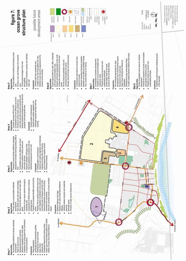
79 C-38
80 Areas Opportunities Constraints Area 1 Wallington Road west of Ocean Grove Accommodate potential low density residential development Views to sea and river Gateway/entry point to town Attractive topography from small valley Pedestrian and cycling green link Not within the time frame of the Structure Plan Impact upon environmental and habitat values of Ocean Grove Nature Reserve Located outside proposed settlement boundary Steep topography exposed topography Landscape and environmental qualities Coastal Spaces SLO recommendations Edge of town and substantial distance from activity centres Area 2 North Eastern residential development corridor Area 3 LDRZ area Shell Road Area 4 RLZ Banks Road Primary area to accommodate residential development Ability to accommodate new activity centre with main road frontage adjacent to new school site and major open space Provision of open space networks throughout residential area with Integration of pedestrian and cycling link connecting Lake Connewarre and the Coast Incorporation of WSUD principles to address drainage issues Potential for increased densities around activity centre Potential links to existing residential area to the south Vehicular connection points to Grubb and Banks Roads Consider rezoning existing LDRZ to R1Z only if property owner and community support Consolidation and more efficient use of land Proximity to parkland, activity centre and community services. Improved utilisation of Kingston Park Improve pedestrian connectivity with new residential development to the north Consider rezoning of RLZ to R1Z Strong resident support Consolidation and more efficient use of land Proximity to activity centre, parkland and community services Improved connectivity with existing residential development to the west Bellarine Highway hard edge Maintain non urban break before Bellarine Highway Interface between industrial and residential precincts Drainage issues Existing pattern of development fragmented ownership Impacts upon unique vegetation and landscape character which with Kingston Park provide important habitat values are likely with any rezoning Lack of support from property owners Proximity of industrial land uses not appropriate to further consolidate residential densities. Existing pattern of development fragmented parcels Impacts upon existing scattered vegetation and landscape character are likely with any rezoning Requires Outline Development Plan or similar to coordinate development and provision of infrastructure C-39
81 Area 5 Proposed future industrial and restricted retail precinct Area 6 Town Centre Area 7 Consideration of tourist accommodation site specific Provide additional industrial and business zoned land Provide a main road frontage to the industrial area Provide active frontages to the main thoroughfare Clustering of industrial, business and restricted retail uses Expand opportunities for retail, office, residential and tourist accommodation uses. Expand commercial opportunities to the north. Increase the scale and built form of the town centre Provide improved pedestrian links and connections throughout the centre Manage vehicular access and parking issues Views of the coastal environment Opportunity for sensitive development above escarpment line including tourist accommodation and conference facility utilising eco-tourism and sustainability principals Uninterrupted views to the coast Access to Shell and Banks Roads Interface with future residential area Located on the main thoroughfare into town therefore could reduce the appearance of the entrance to the town Cumbersome road network to access town centre for tourists Individual ownership of business properties therefore can be difficult to facilitate change Town Centre limited to The Terrace Not considered appropriate for urban or residential development due to environmental impacts Escarpment to the south east Edge of town development defined by topography Development creep across Banks Road Principles for Identified Development Areas Special Development Areas The land located generally at the north-east corner of Bonnyvale Road and Ocean Thoroughway, Collendina has the potential for tourist related development, subject to consideration of environmental implications and sensitive design response, the nature of the development that may occur. The area comprises: The Collendina Resort including a hotel, motel, boat shed and associated infrastructure. Existing facilities are modest and do not utilise the attributes of this site to the fullest. A permit was recently issued for a retirement village of approximately 160 dwellings, communal facilities and an aged care hostel (40-60 beds). Stage 1 of construction has commenced north of the existing hotel. Stage 2 of the project is in preliminary pre-application stages involving demolition of the existing hotel buildings and constructing a new hotel with drive through bottle shop facilities and, relocating the aged care hostel further south on the site. Development at this site which provides for aged care accommodation and improved accommodation and entertainment options is supported where site design complements the coastal setting and character. While the rural zoning has not impacted upon the capacity to consider development applications for this site an examination of the best zone for the site is warranted closer to development completion. The site should be included within the settlement boundary. The Collendina Caravan Park, occuping an outstanding location at the rear of the primary dune system running along the coast. It is an environmentally sensitive area adjacent to the Lake Victoria wetlands and Buckley Park Foreshore Reserve. Existing facilities are modest with some 300 sites. Capacity exists to provide for additional sites and this is supported where development can be managed in a manner which does not impact upon the environmental significance of the location (including dunes and wetlands) and design treatment is consistent with and contributes to the strong coastal landscape character. C-40
82 Development and zoning determination for these sites should ensure the following principles: Use for tourism or environmental and related facilities only. A master planned approach to the development of the site. Development displays a high degree of sensitivity and responsiveness to the environmental features and characteristics of the site and its surrounds. Development achieves a high quality design outcomes. Development that does not adversely impact on the coastal foreshore environment or, on the wetlands of Lake Victoria, and which includes measures to enhance these sites environmental features. Significant environmental enhancements are proposed in conjunction with the development of the land. Development includes the opportunity for use by the general public i.e. public access through the sites to assist in the establishment of the environmental town link Other Residential Areas Rural Living Zone (RLZ,) land adjacent to Banks Road and Shell Road (Area 4) If generally supported by land owners in the area, investigate the possibility of rezoning land currently zoned Rural Living (RLZ) adjacent to the west side of Banks Road to a Residential 1 Zone (R1Z). This would be achieved through the implementation of an Outline Development Plan (ODP) for all of the land currently zoned Rural Living. The land would then be covered by a Development Plan Overlay (DPO) and future development would proceed in accordance with this plan. The development plan would address the following: subdivision pattern and layout; subdivision staging; retention of remnant vegetation; the potential for a new collector road to extend along the western edge; and revised road network and connections to the residential estate to the west Areas not considered appropriate for development at this stage Low Density Residential Zone (LDRZ) adjacent to Kingston Park (Coolamon Close) Area 3 Rezoning of this area is not supported at present given; Extensive cover of native vegetation extending to Kingston Park to the west. This vegetated area is unique to the town and of high biodiversity value. Development of smaller lots and additional dwellings on the land will significantly compromise habitat values within the lots and the habitat values of adjoining vegetation within Kingston Park; Providing additional residential development adjacent to existing and future industrial areas is not supported is likely to impact on the operation and viability of the industrial estate. Any future consideration of this area for rezoning should be accompanied by the implementation of an Outline Development Plan (ODP) to ensure a co-ordinated change to all of the land within the same zoning. The following requirements should be addressed in the ODP: The existing vegetation within the area should be protected to ensure the landscape qualities of the area are retained; The provision of larger lots than exist in a typical residential area; Careful road treatments which maintain informal footpaths whilst providing a north-south link from Kingston Park to the proposed new residential subdivisions to the north; Provide for road reserve/open space links to future subdivision to the north; and Provide a connection between a new collector road in north and Coolamon Drive to allow pedestrian and vehicular movement from the north to Shell Road. C-41
83 Land generally between Wallington Road and western edge of Ocean Grove Nature Reserve Area 1. This area is not considered appropriate for future development within the time frame of this Structure Plan for the following reasons: The environmental qualities of this area are considered significant enough to preclude development. This relates to proximity of the land to Ocean Grove Nature Reserve and the significant flora, fauna and wildlife qualities that exist within the reserve; This area would not be appropriate for a rural residential zone given State Government direction that requires limited land is to be rezoned fur rural residential purposes; The area is an important gateway entry to the town and future development could impact upon the attractiveness of this entry; Population projections up until 2020 indicate that north-eastern residential area can accommodate the proposed population increases forecast for the town and therefore further residential development to the east of Wallington Road is not necessary; The southern boundary of the Ocean Grove Nature Reserve has historically been seen as the edge of the town. Development beyond this point is contrary to the providing a sense of containment to development east of Grubb Road; and The Barwon River Estuary is of regional significance and therefore the landscape character of this area should be protected from development pressures that may result in environmental impacts from stormwater drainage and runoff Special Investigation Area - North east corner of Banks Road The area at the north-east corner of Banks Road and Shell Road is identified as a possibility for locating an environmentally sensitive, master planned tourist facility given its unique views of the coast and significant wetlands and proximity to the urban edge. It is considered that a suitably designed eco-tourist facility would complement the tourist offer within the town and offer a unique opportunity to enable visitors to experience and appreciate the coastal setting and surrounding wetland environment. This site which needs to be carefully managed however given its location and to avoid a detrimental impact on the landscape and environmental values of the locality and to avoid a eastward creeping form. The area of interest should generally be limited to areas above the landform escarpment towards the south-west of the site (occupying up to 50% of the total land holding). It is considered that such a development should meet the following objectives: Be a tourist related (permanent residential uses are not supported) activity preferably related to the enjoyment/appreciation of the coastal-wetland environment experience Be of an appropriate scale and design which responds to the land form and minimises impact on the landscape Be well landscape utilising indigenous coastal plantings Buildings and majority of tourist activities and facilities located above the primary escarpment line. To accommodate such an activity the current zoning is to be retained pending a more detailed investigation of site development options (possibly as a combined rezoning and permit application). In the interim a portion of the total site will be included within the settlement boundary which may require some further refinement. Key influences The town caters for both holidaymakers and permanent residents with, future growth requiring the integration of community facilities and urban services in a sustainable and accessible manner. C-42
84 Whilst a major town in the Bellarine Peninsula offering a range of lifestyles, cultural and natural environmental attributes, there is a need to establish clear boundaries for its future growth as part of protecting the area s fragile coastal environment. As the town expands and consolidates its urban activities there is a need to provide a sense of place and identity throughout Ocean Grove. Some of the opportunities for reinforcing this identity include interesting signage, landscaping, public art at selected locations, and well defined gateways into the town. 7 Settlement and Housing City of Greater Geelong Neighbourhood Character Study The character study identified 12 precincts within Ocean Grove, with a general vision of promoting a seaside character with strong environmental qualities. The primary features to be encouraged can be summarised as follows: Retain indigenous vegetation; Use building materials complementary to the seaside context; Ensure spacing between buildings; Achieve balance of site coverage between buildings and vegetation; Building height should not dominate streetscape or obscure long views; Reflect predominant building patterns; and Develop public domain street treatments. Building Design There is a wide variety of building styles, materials and eras in the residential areas and the town centre of Ocean Grove. The overall building form is of a low scaled, suburban village with occasional two and three storey forms along the beach front, town centre and primary through route. The existing building design, especially along key routes does not currently reflect the coastal character of the seaside context. The neighbourhood character study identified above reflects the era and a general vision for a future residential form; however the opportunity to encourage a distinctive beachside character is yet to be fully explored. There are a number of key sites that would benefit from guidance and advocacy of a seaside built character. The following sites and areas should be the focus of high quality design and increased density of development. These are: Key entry points such as at Shell Road and the entry from Barwon Heads Primary route through Ocean Grove Shell Road, The Parade etc Corner of Grubb Road and The Parade Intersection of Grubb Road and Shell Road With an aging population it is important that housing be developed utilising walkable catchment principles and be readily adaptable so as to offer choice. When designing new residential areas and housing consideration should be had to the City of Greater Geelong Disability Action Plan. C-43
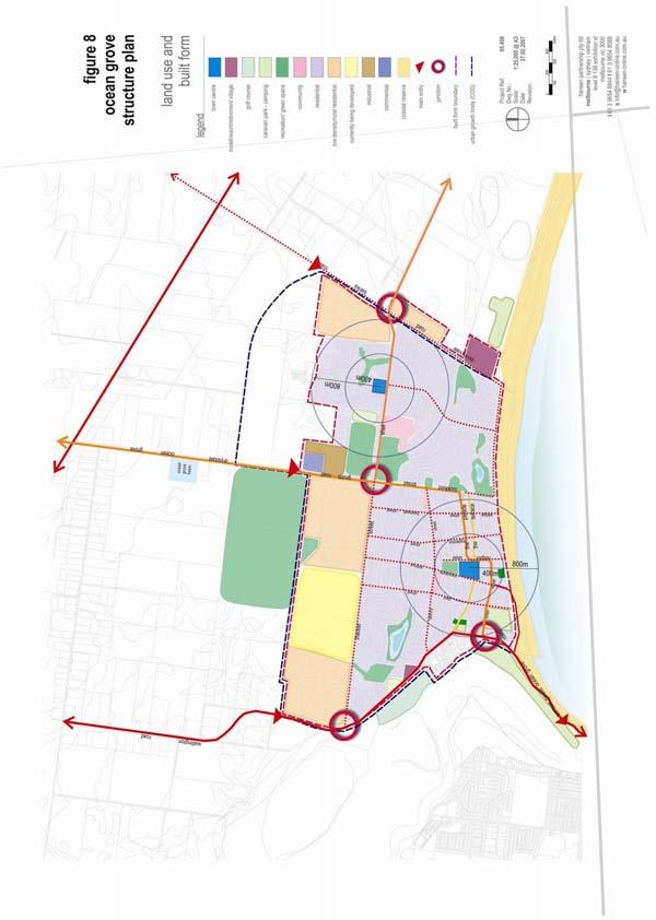
85 C-44
.")
86 Significant Landscape Overlay Schedule 7 (SLO7) A number of issues have been raised by the community and Council resulting from decisions by the Victorian Civil and Administrative Tribunal (VCAT) regarding the application of Schedule 7 of the Significant Landscape Overlay Ocean Grove Coastal Area (SLO7). The overlay covers the existing residential area located adjacent to coast within the original part of Ocean Grove and extending back beyond the Town Centre. Figure 2 outlines the extent of the overlay. A permit is required for specified native vegetation removal, site coverage greater than 70% and building height greater than 7.5m. Figure 2 Extent of Significant Landscape Overlay Schedule 7 (SLO7) From a review of the various VCAT decisions and character of the area it is recommended that a further study be initiated by Council to undertake a detailed review of SLO7 and the Residential Character Areas that apply in the area affected by that overlay. The purpose of that study would be to investigate amendments to enhance consistency between the two documents, and to manage change and achieve better design outcomes in the area covered by SLO7s and application of the most appropriate VPP tools. Further detailed comments regarding matters that should be included in that review and possible solutions to existing issues are made later in this report and should be referred to directly. The intent of the overlay is to protect the landscape character of the coastal area, whilst balancing development pressure with landscape qualities. The objectives of SLO7 include: Preserve balance between roof tops and vegetation in long distance views; Encourage development to fit within the landscape and not dominate the streetscape from long distance views; Minimise projection of buildings above the tree canopy; Provide space around buildings for retention of and planting of vegetation, particularly canopy trees; Maximise opportunities for view sharing; and Protect vistas of the ocean and the river from public viewing points. The particular issues covered by SLO7 include building height, location of outbuildings, site coverage and removal of vegetation. A planning permit is triggered by SLO7 if any of the following are proposed: buildings exceeding 7.5m in height; outbuildings normal to a dwelling projecting forward of the front building line; and site coverage of buildings or impervious surfaces exceeding 70 per cent. C-45
87 The reference to building height is included in the SLO given that DDO 14 (Dwellings over 7.5 metres) effectively covers the remainder of the town. DDO14 requires a planning permit for all buildings (including a single house on a lot) exceeding 7.5m in height. There have been a number of decisions made at the Victorian Civil and Administrative Tribunal (VCAT) regarding properties where the area was covered by SLO7 that raise issues regarding SLO7. Discussions with Council officers have also highlight issues that need to be resolve in relation to the SLO. Some of the issues identified include: The urgent need for SLO7 and the Residential Character Areas that apply to the SLO area to be reviewed to provide for greater guidance, consistency in application and achievement of the Overlay purpose. Issues related to when the SLO triggers the need for a planning permit, and how the provisions of Clause 54 and 55 prevail over the objectives of the SLO for medium density development when a planning permit is not required under the provisions of the SLO. The need to control subdivision (An SLO cannot be used to control subdivision however, subdivision within these areas has a tangible impact on landscape and character values) The need to clarify the exemptions that allow vegetation to be removed without the need for a planning permit, and to address the issue that tea tree can be removed without a permit from some parts of the area but not other parts, particularly where tea tree is often the predominant vegetation type and recognised within the Overlay purpose. Lack of design guidance. The following comments are made in relation to these issues: The provisions of SLO7, Council s Residential Character Study, and other DDOs (particularly DDO14) need to be logically integrated, supportive of each other, and when combined must provide an appropriate and a consistent set of controls and guidelines over residential areas in Ocean Grove. This is not the case at present. It is beyond the scope of this study to review the Residential Character Study and resolve all issues in relation to that study and these overlays. That will require a separate strategic study. However it is possible to provide some direction in this structure plan about matters that need to be addressed in that review. There seems to be a belief in the community that SLO7 prohibits development above 7.5 metres. This is not the case. It merely extends the permit trigger contained in DDO14 (which applies to all other Residential 1 Zoned land in Ocean Grove and the City of Greater Geelong) to apply to land within the overlay area. Whether or not the need exists for a permit for all buildings in a Residential 1 Zone that exceed 7.5 metres in height is a strategic decision for the wider municipality. Whilst DDO14 remains in place, retention of the control is appropriate in Ocean Grove and within the SLO7 area. The purpose of the trigger is to enable the responsible authority to assess the impact of taller buildings on the landscape objectives stated in Schedule 7 to the SLO. Community misunderstanding about the purpose of the SLO should be addressed by communicating the correct purpose of the SLO to the community. A key intent of the SLO is to maintain a balance between roof tops and vegetation in long distance views. A key objective to achieve this is the provision of open space around buildings for the retention and planting of vegetation. This intent is appropriate. Council s planning staff have raised an issue regarding ambiguity in the meaning of the phrase around buildings. This could be addressed by substituting the words at the front, rear, and side of buildings. The objectives and guidelines contained in SLO7 are only taken into account when a development proposal triggers a need for a permit pursuant to that clause. For example, a planning permit is required for two or more units on any lot within the area covered by SLO7 pursuant to the provisions of the Residential 1 Zone. Pursuant to the provisions of the Residential 1 Zone the provisions of Clause 55 of the planning scheme set out the matters that can be taken into account in deciding if a planning permit should be issued. However if the development is not higher than 7.5 metres and does not exceed a site C-46
88 coverage of 70% etc, then the need for a permit pursuant to the SLO7 is not triggered. In such a case, which is common, none of the objectives or decision guidelines of SLO7 can be used in the assessing the application. It is considered that all multi dwelling development should be assessed against the provisions of SLO7. This could be achieved by changing the wording of Clause 3.0 of Schedule 7 to require a permit for all buildings or works where two or more dwellings are proposed on a lot. A key intent of the SLO is to limit site coverage to allow for increased landscaping. This intent is appropriate to remain for this part of Ocean Grove, as strategic justification for such a treatment is contained in the Residential Character Study. However there is an inconsistency between the Residential Character Study and the SLO in terms of site coverage. The wording used to express site coverage is also confusing, as it is expressed as a double negative. There would also seem to be a misstatement of intent. For example, Clause 3.0 of Schedule 7 states that a permit is not required for buildings and works if At least 30% of the site is not covered by buildings or impervious surfaces including driveways, paving, swimming pools or tennis courts. What this means is that a permit is not needed pursuant to the SLO unless the site coverage is 70% or more. This is an extremely high site coverage and is unlikely to be exceeded in many cases. As a result, this provision is rarely likely to trigger the need for a permit pursuant to the SLO. As a comparison Clause 55 (which applies to multi-dwelling development) refers to a maximum site coverage of 60%. It is suggested that the site coverage trigger be reduced to 30% site coverage i.e. 70% a site free of buildings and works. This will ensure that the objectives and decision guidelines of the SLO can be taken into account and adequate space around building can be provided to meet the objectives of the overlay. It should be noted that the Residential Character Precincts that relate to most of the area covered by SLO7 refer to 45% of a site being free of buildings (i.e. a site coverage of 55%). As part of the recommended review of the Residential Character Study, the need for consistency in site coverage between the SLO7 and the relevant character precincts should be examined. There is also a view that there is little difference between the design objectives of the various character precincts and that they provide little value in achieving improved design responses. There is a need for greater design guidance which may be better achieved by an additional Overlay (i.e. DDO) to achieve a seaside character for the original parts of the town. This is something that should be considered as part of the Residential Character Study. There is also a need to re-examine the boundaries of SLO7 and the boundaries of the residential character precincts that apply to that area. The area presently covered by SLO7 includes Residential Character Precincts 4, 5 (small part only), 6, 7 and 12. Only Residential Character Areas 4, 6 and 7 contain an objective and a response that relates to site coverage. It is recommended that the review investigates the need to include an element in Character Area 12 that relates to site coverage. In addition SLO7 presently applies to land around the Ocean Grove Town Centre. This structure plan supports the rezoning of land to the north and to the east of the town centre, and supports increased building heights in those areas. This study recommends that an urban design framework be prepared to address the issue of building height around the town centre. Once that study has been undertaken it maybe appropriate to delete SLO7 from areas to be rezoned around the Town Centre. The possibility of deleting SLO7 to the west of Wallington Road, namely Precinct 4 should also be investigated, as that area is relatively flat and does not have the vegetation character of the balance of the area covered by SLO7. There is no opportunity in a SLO to require a planning permit for subdivision. Whilst a permit is required for all subdivision in a Residential 1 Zone, that trigger does not enable the objectives and guidelines of SLO7 to be taken into account in assessing an application. One option is to include a policy statement in the local planning policy section of the planning scheme, stating that in assessing a planning permit application for a subdivision in that part of the Residential 1 Zone covered by SLO7, the responsible authority should have regard to the objectives and decision guidelines of that overlay. Council officers are concerned that exemptions exist in Clause 3.0 of Schedule 7 that enable vegetation to be removed without the need for a planning permit, which may adversely impact on the character of the area. The removal of tea-tree is one issue. Clause of the planning scheme identifies tea-tree in the coastal fringe area as being a noxious weed. This means that in those parts of SLO7 close to the foreshore a permit is not required to remove tea-tree because it is a noxious weed and is exempt from the C-47
89 controls, whereas elsewhere in the overlay area a permit is required. This situation could be overcome by amending the wording of Schedule 7 to require a planning permit for the removal of tea-tree throughout the entire SLO7 area. Discretion could then be exercised to provide greater flexibility to remove tea-tree in environmentally sensitive areas in the coastal fringe, than elsewhere through the SLO7 area. The exemption in relation to vegetation less than 4 metres in height or with a circumference of less than 0.5 metres measured 1 metre above the ground, should also be reviewed to make it more stringent, but without requiring a permit for the removal of all vegetation within the overlay area. Benefit would exist in preparing design guidelines to clarify the issues Council sees as relevant in considering planning permit applications in the area covered by SLO7. This would provide design guidance and assessment criteria to better inform developers and the community about the role, purpose and application of the overlay. Consideration needs to be given to the practicality of applying such controls to large non typical residential sites such as caravan parks where much of the vegetation has been reinstated. Description of Coastal Character A number of references are made to coastal character throughout the report, these include an informal planting style including coastal tree species and other native species of trees and shrubs. This style of planting could be established in new subdivisions through landscape assessment guidelines and adequate front and side setbacks to allow for landscape to establish between buildings. The style of architecture and building design includes varied forms and materials including non conventional roof forms, a high degree of articulation and varied materials often utilising considerable amount of timber, metal, glass, earth colours or brighter coastal colours. Discussion The housing needs of the community are derived from an evaluation of the ABS data from which future population projections for the town can be calculated. With growing numbers of the ageing population and smaller household sizes the need for a diverse housing stock is required. Opportunities for medium density housing should be considered in around the town centre and any future activity centres. The provision of housing should also consider providing tourist accommodation. Both new residential subdivisions and infill development need to be balanced with objectives of neighbourhood character to ensure future development maintains the landscape coastal character of Ocean Grove. Ocean Grove has a considerable number of overlays relating to design and built form, vegetation and landscaping that assists in achieving built form which balanced against the landscape qualities of the town. This is further achieved by the City of Greater Geelong Residential Character Study 2001 which outlines preferred character statements for each of the precincts with comprehensive design guidelines. These guidelines assist in creating desired built form outcomes. Key influences Future growth in the residential population should be accommodated through a combination of sensitively designed new residential subdivisions and infill housing. A range of housing types and forms from single dwellings to medium density housing is required to cater for the needs of community as it ages and grows, as well as the diverse needs of the tourist market. Medium density housing should be located in close proximity to the Ocean Grove activity centre and other activity centres, major open spaces and public transport routes. The established character of the town is a valued element to the community. The undulating coastal setting, generally low scale of buildings and canopy trees in parts of Ocean Grove are integral to this character. The opportunity to reinforce a seaside character may be addressed though reference to the coastal vegetation, undulating topography, focus on future public spaces and availability of limited sea views. C-48
90 8 Infrastructure Services Infrastructure Hansen Partnership engaged EarthTech to review the availability of infrastructure within Ocean Grove based on consultation with the respective government agencies. Figure 11 illustrates the areas considered by the assessment. Outlined below are those elements of the existing service infrastructure in Ocean Grove that have been analysed in the report. The existing system west of Grubb Road and north of Thacker Street cannot accommodate further urban development and options to extend the system are limited because of existing low density development and Ocean Grove Nature Reserve. System extensions are possible from the existing residential development north of Shell Road extending west to Grubb Road and north to the south boundaries of lots fronting the Bellarine Highway and in the rural residential subdivision in Banks Road and land immediately to the north. Water Supply The State government has released several key documents relating to water resource management in Victoria. The Securing Our Water Future together White Paper, released in 2004, acts as an over-arching document outlining an array of measures to improve management of Victoria s water resources. More recently, the Central Region Sustainable Water Strategy (CRSWS) outlines resource distribution and equity amongst all users within the Central Region of Victoria. Barwon Water was involved in the development of this strategy. The final CRSWS, released on the 17th October 2006 identifies additional water resource and conservation options available to increase the sustainability of the region s water supply system, including surface water, groundwater and recycled water options. A new requirement in the CRSWS is for Barwon Water to continue to work with its customers, including local government, to achieve a 25 per cent reduction in total per capita water use by 2015, increasing to 30 per cent by The basis of comparison is the 1990 s average water use. On a local level, and also a White Paper initiative, Barwon Water is finalising its Water Supply Demand Strategy (WSDS), which provides details on supply and demand forecasts for all of Barwon Water s water supply systems and presents a strategy to achieve a supply-demand balance for each. This balance is achieved by a combination of water conservation and additional supply options. The WSDS will include many of the options included in Barwon Water s 2003 Water Resources Development Plan. The WSDS also identifies other areas where joint action by Barwon Water, local council and government agencies can contribute to improving the efficiency of water resource management, These aspects include, for example, consideration of mandating water sensitive urban design in new development, regulation of water efficient appliances at point of sale and review of the incentive framework for customers purchasing water saving goods or appliances. The Ocean Grove Water Supply System provides water to the Ocean Grove and Barwon Heads townships. Treated water is transferred from Barwon Water s Wurdee Boluc Water Treatment Plant, by gravity, to a 20 ML (million litres) covered tank located in Grubb Road, to the north of Ocean Grove. The Ocean Grove Tank is located on land to the south of and adjacent to the Ocean Grove Basin site. The 216ML basing was the original water supply system for the area and is no longer in service. There are no current plans to redevelop the basin site. The Ocean Grove Tank can supply all of Barwon Heads and most of Ocean Grove by gravity. However, the area generally north of Thacker Street and Shell Road is to high an elevation to be satisfactorily serviced from the Ocean Grove Tank. A booster pump station, located in Grubb road near the Woodlands Estate, boosts pressures to customers in this area. The booster station only has capacity to service areas currently zoned for residential, rural living or special use zone (Goandra Estate). C-49
91 The North East Residential Development Corridor cannot be supplied from the Ocean Grove Tank by gravity, as the land is too high. There is no spare capacity in the Grubb Road Booster Pump Station to accommodate it. A new booster Pump Station would therefore be required and another tank adjacent to the existing one. These facilities could be located at the existing tank/basin sites. Augmentation of other elements in the transfer system may also be required dependent upon growth in other areas of the Bellarine Peninsula. These should not affect the current structure planning process. Sewerage System Ocean Grove is serviced via conventional gravity sewerage system including four sewerage pump stations (PS), which pump flows across the Barwon Heads Bridge to the Black Rock Water Reclamation Plant (WRP) at Breamlea. The majority of the system was constructed in 1969 with Ocean Grove pump station No.4 constructed in The main trunk system incorporates Ocean Grove PS1, PS2 and Barwon Heads PS1, which all currently pump into a common rising main that transfers flows to Black Rock WRP. The existing system is currently operating at, and in some sections, beyond its original design capacity, particularly during high flow periods over summer weekends and holiday periods and during peak wet weather. Also, the pumping arrangements that have evolved over time at Ocean Grove and Barwon Heads are not ideal and there is limited capacity in the sewer main crossing the Barwon River (attached to bridge) and extending to Black Rock. All low-density development north of Thacker Street is currently sewered and it is proposed to sewer the future Goandra Estate. The only limitation to extending the sewerage system northwards is the capacity issues in the downstream sewerage system. The BPSMS has identified works required to alleviate these capacity issues for development north of Shell Road, however future development north of Thacker Street has not been considered. For these reasons combined, the current Ocean Grove sewerage system does not have capacity to cope with a potential doubling in population, and the subsequent sewage flows and significant works will be required to meet demand and reduce the risks of ewage spills to the environment. The Bellarine Peninsula Sewerage Management Study (BPSMS), which incorporates Ocean Grove, commenced in August 2005 and is scheduled for completion by December The BPSMS will determine sewerage strategies required to accommodate existing and future development within Ocean Grove and the wider Bellarine Peninsula for the next 40 years. A preliminary conclusion of the BPSMS is that the strategic direction for sewerage on the Peninsula should be the continued operation of conventional sewerage systems in the southern (including Ocean Grove) and northern areas. This would involve continued transfer of flows to a centralised treatment plant at Black rock WRP for treatment and disposal or recycling. Growth in the eastern Peninsula would be accommodated by expansion of the existing Portarlington Water Reclamation Plant (WRP). Local treatment and recycled water schemes where investigated for both the northern and southern system, however, these are not considered feasible, based largely on the limited secure and consistent demand for recycle water in the Ocean Grove area. The larger potential recycled water users, are located mostly around the Portarlington area (agriculture, vine yards, golf course), and to a lesser extent at Clifton Springs (2 golf courses). The limited potential demand in the Ocean Grove region for recycled water also means that local treatment and reuse would only take a minor component of the sewage flows off the existing system, meaning that upgrades to the trunk system would still be required to accommodate future increased flows. Based on the preliminary conclusions in the BPSMS, approximately $19m would need to be provided in Barwon Water s capital works plan for several conventional upgrade projects across the Southern Bellarine sewerage system, including Ocean Grove. These projects need to occur to meet the current demand. Some of the projects and the predicted timing include: 2007/08 Installation of emergency storages at Ocean Grove pump stations 1,2,3 & 4 C-50
92 2008/10 New pump station west of Barwon Heads and new rising main to Black rock WRP. This will transfer 100% of the sewage flows from Ocean Grove, Barwon Heads and Queenscliff/Point Lonsdale to Black Rock WRP. 2010/11 Upgrades to Ocean Grove Pump Stations 1,2,3 & /11 Ocean Grove Rising Main No.1 duplication (from PS 1 to Rising Main No 2 at the Ocean Grove Surf Life Saving Club car park). 2010/11 Ocean Grove Rising main No.2 replacement (from Ocean Grove spit to Barwon Heads West PS, along The Esplanade including the Barwon River crossing). Additional infrastructure projects will be required to meet the predicted growth in the draft structure plan however; more information on the timing and location of this development is needed before these details can be determined. The Barwon Heads Bridge has significant strategic importance to Barwon Water as it currently supports the only pipeline that transfers Ocean Grove s and Queenscliff s sewage to Black Rock WRP. This Pipeline has limited capacity and in order to accommodate the existing flows and the growth proposed in the Structure Plan, the pipeline will require replacement by If the bridge issue is not resolved by 2008 (allowing for 3 years of planning and construction) then Barwon Water will need to seek approval for installation of a new pipeline under the river. This is not Barwon Water s preference as there are higher costs and environmental impacts during construction, high risks during operation and no guarantees that other relevant authorities, including COGG and the Corangamite CMA would support this action. It is likely that a new sewage pump station will be required at Banks Road to service the extreme eastern section of the future northern residential development. The pump station would pump sewage into a new rising/gravity main to the existing Ocean Grove Pump Station No.4, located in Bonnyvale Road. This pump station will need to be upgraded to accommodate these flows, including the construction of an enclosed 1 ML detention storage on site, to store peak wet weather flows during peak storm/rain events. This will be in addition to the existing 7ML open emergency storage currently located on site. The remaining development north of Shell Road (approximately 240ha) will be serviced via the extension of four collecting gravity sewers (225mm and 300mm in diameter). These sewers connect to the Shell Road Interceptor Sewer, just north of Shell road. The Shell Road Interceptor Sewer does not have the capacity to accommodate the expected future 3600 lots 15 lots/ha). Therefore, it is likely that some of this catchment may need to be diverted to the new pump station and Banks Road. Power Supply Power supply is generally available but subject to the extent of urban expansion and associated demand for power upgrade/augmentation of High Voltage Supply may be required in the future. Powercor has long term plans for a Zone substation in the Industrial estate east of Grubb Road. Powercor have advised that a site with the dimensions of 100m x 100m (1ha) would be required. Gas Supply An adequate gas supply is available for existing and future urban expansion. Telecommunications Adequate facilities are available for future urban expansion. Stormwater drainage Generally there are no constraints to urban expansion provided stormwater management facilities and Water Sensitive Urban Design WSUD principles and regimes are integrated into future urban design and layout. C-51
93 Discussion The assessment undertaken by EarthTech notes that there are sufficient connections available for water, sewerage, power, gas, telecommunications to the area east of Grubb Road to Banks Road and north to the southern boundaries of properties fronting the Bellarine Highway. There are some limitations to water and sewerage to the west of Grubb Road given the Low Density Residential Zoned land. Appropriate stormwater management and Water Sensitive Urban Design principles will need to be incorporated in future residential areas. With both infill and new development drainage systems require assessment and appropriate upgrades where necessary. This may include augmentation of existing systems and/or replacement with modern day drainage systems using the latest in technology Access and Movement Infrastructure Hansen Partnership Pty Ltd engaged ARRB Consultants to undertake an assessment of the access and movement issues within the study area of Ocean Grove. The key findings of the report were a result of a review of the following reports (note this report was prepared prior to any decisions in regard to the Barwon Head s Bridge by the Minister for Planning or Advisory Committee): Draft Ocean Grove Traffic Study (March 2006) prepared by Andrew O Brien; Draft Ocean Grove Town Centre Parking and Access Study (March 2006) prepared by Andrew O Brien; Ocean Grove Car Parking Precinct Plan Study Report (July 2003) prepared by Traffix Group in association with EarthTech; Geelong Transport Strategy (December 2003); and Bellarine Peninsula Strategic Plan, Ocean Grove Township Objectives (October 2005). The key findings of the ARRB consultant report include: Improved road access is required to the Ocean Grove Market Place activity centre on Shell Road. Plan for the future duplication of Grubb Road given it is the major route to and from the town. Upgrade Banks Road, Kingston Downs Drive and Bonnyvale Road to become collector roads; and Develop bus route plan for future development to the north east and advocate for the reform of existing bus routes and services across Ocean Grove. The report outlined some of the characteristics of the existing town, these include: Four main road access points to the town; The existing VicRoads declared road network; Large areas of the town do not have access to a bus service, the indirectness of the routes are a further disincentive to use the bus for a trip. Service frequencies are 1 to 2 hours, with variations to routes during the day and school holidays. Kingston Park is isolated from future residential subdivisions to the north by a barrier of low density housing to the north of the park. The debate regarding The Terrace vs. The Parade as the main thoroughfare is ongoing. It notes from past studies that the issue of making The Terrace the main thoroughfare is unlikely to be achieved due to costs associated with the upgrade. The link between the two roads is suggested by Andrew O Brien however, this is unlikely to be achieved due to the cost. There is development pressure to extend the Town Centre eastwards, however there is concern regarding crossing Hodgson Street and look at concentrating development around the existing car parks servicing the town centre. The road hierarchy is poorly defined, with VicRoads Declared Main Road route and only two collector roads. A number of other streets are functionally acting as collector roads, i.e. Presidents Avenue, Bonnyvale Road etc. C-52
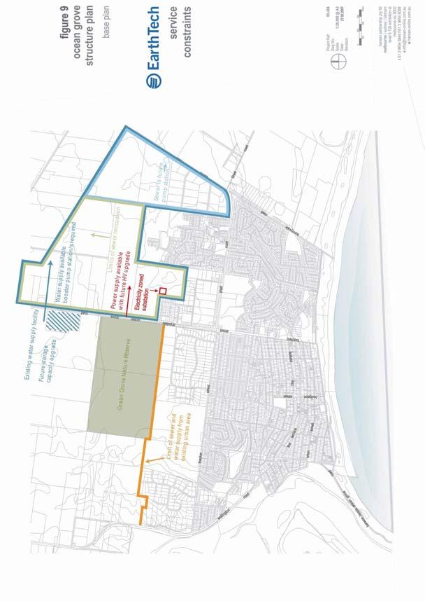
94 C-53
95 Many local roads include line marked bicycle lanes, however they are often used by residents as car parking lanes. This issue becomes more crucial during holiday periods further restricting cycling movements. The report outlined future issues to be addressed, these include: Formal recognition of a collector road network, to raise local awareness and influence land use planning decisions. The low density development of Goandra land located on the north side of Thacker Street inhibits further subdivision to the north or at a higher density, most probably resulting in a highly car dependent subdivision. Seek more intense development within existing urban areas of Ocean Grove and within the walking catchment of Ocean Grove town centre. Future street networks should be based on grid patterns for pedestrian and cyclist movements with roads suitable for future bus services. Community services and convenience retailing should be clustered around future bus stops. All housing should be within 400m of bus stop that is part of a direct route. Further residential development north of Shell Road, should have pedestrian, cycling and bus links to Ocean Grove Market Place, school and recreation precincts along Shell Road. Local services and convenience shops should be provided as further development proceeds. The development should also connect to Banks Road. A new bicycle route to the town centre could be achieved from the proposed shared path along the southern edge of the Ocean Grove Nature Reserve, Woodlands Drive connecting with Presidents Avenue. Future duplication of Grubb Road is recommended, keeping in mind protection of the existing vegetation, acquisition of land to either side might be required to enable suitable road median. Future intersections with roads leading into east of Grubb Road should be limited and determined in conjunction with VicRoads. Banks Road should be progressively upgraded to a collector road standard with appropriately designed intersections at various junctions. Bonnyvale Road is functioning as a collector road, traffic from Banks Road will contribute to Bonnyvale Road. The suggested road hierarchy in the draft Ocean Grove Structure Plan (March 2006) is recommended as supporting future residential areas to the north, however there is a clear gap in the proposed hierarchy north of Shell Road. It is suggested that Kingston Downs Drive and Banks Road be upgraded to collector roads. If Option 2 is chosen for the Barwon Heads Bridge then it is suggested the existing bridge should be retained as a recreational walking and cycling circuit for the two communities. The new location of the bridge would bring the two communities 1.5km closer reducing the travel distance. Comments from the Bellarine Peninsula Community Service Plan (2005) support these findings and identify key issues regarding access, movement and connections within and around the town and the Bellarine Peninsula include. These issues are important by improving access opportunities for those sectors in society that are often disadvantaged including the young, elderly and young families. Discussion Generally traffic and movement reports have identified that Ocean Grove requires improved access to public transport, improved traffic movement and management around and through Ocean Grove (especially through The Terrace and The Parade), a clear and functional road hierarchy, traffic calming measures and an expanded centrally located public car park. VicRoads has indicated that the duplication of Grubb Road is a high priority for Ocean Grove. As the town increases in size the opportunity for a town bus service should be investigated with the Department of Infrastructure (DOI) so that the town is more adequately serviced by public transport. C-54
96 The reports generally agree that future planning should be based on street networks aligned in a grid patterns for pedestrian and cyclist movements with roads suitable for future bus services. Community services and convenience retailing should be clustered around future bus stops and new housing should be within 400m of a bus stop that is part of a direct route Community Services Infrastructure Child Care and Kindergarten Comments from the Bellarine Peninsula Community Service Plan (2005) note that there has been a high proportion of children living in Ocean Grove who have been in early childhood education and care (95.4%). Some of the key issues raised include: The need for increased provision of childcare, increased flexibility and operating hours of local and early childhood and family support services; Increased ongoing Council support for community based activities for toy libraries and playgroups was also noted by parents; and Access to affordable childcare services for low income families. Other increases in services from future population projections particularly young children include: An increased number of kindergarten sessions, ranging from 7 11 sessions by 2020; Approximately 2 3 additional child care centres providing 90 places per centre; and Capacity for at least one additional maternal and child health nurse within a current or new facility; With the number of young families residing in Ocean Grove and the likelihood of more families to be accommodated with the future growth of the town, the provision of early childhood services will need to be increased. Education Primary and Secondary The town currently has three primary schools, with the projected future growth of the town it is likely that an additional primary school will be required. A new primary school will service the residential catchment north of Shell Road. The calculation for a primary school is based on approximately 3,000 households per additional primary school. The current secondary school provides education for students up to Year 8 with approximately 400 students, from thereon students travel to the Bellarine Secondary College (Drysdale Campus) for Years 9 12 that services the Bellarine Peninsula. The site provides the capacity for further expansion. A secondary school provides a community hub and therefore the expected growth of the town, a complete Year 7 12 secondary school would provide a positive outcome for the community. Open Space, Recreation and Entertainment Some of the key issues from the various reports investigating open space and recreation matters include: A lack of informal and formal (sporting) open space north of Shell Road; A number of existing parks and reserves are underutilised due to poor access; The need for improved pedestrian and cycling access throughout estates, to achieve a higher degree of walkability and connectivity; The need for an indoor swimming pool and multi functional indoor sporting facility. These issues are currently being considered for Shell Road Reserve, building upon the existing Surfside Community Centre. C-55
97 C-56
98 Ocean Grove has the highest proportion of youth on the Bellarine Peninsula with the sector of the demographic profile expected to increase in the future. Entertainment issues for youth are also raised by the community, the provision of a hall/cinema/events venue is seen as something to benefit the youth of the community. Other suggestions provided by the community include a youth drop in centre/internet café, active recreation challenges and improved access to the Potato Shed where youth cultural events are held. Medical/Community Services The Ocean Grove Medical Clinic is essentially the only large medical practitioner s office in Ocean Grove and is currently fulfilling the medical needs of the local community. The primary care and maternal and child health facilities in Ocean Grove and the Ocean Grove Community Health Centre also provides allied health to the community. The Ocean Grove Neighbourhood Centre is available to provide art and computer classes and services such as children s playgroup to the community. While these services and facilities are meeting the current needs of the community, in the future there will be a need to address medical, aged care and other health-related service demands. In particular it is likely that 6 16 new GP s will be required depending upon growth and the current ratio of GP s per 1,000 adults, given Ocean Grove is a sub-regional centre for Point Lonsdale and Barwon Heads. There is currently a Council customer service centre, library, neighbourhood house and maternal and child health service with community health centre located within the town centre. Growth in the service levels of these facilities will need to be addressed subject to future increases in population. Aged Care In 2001 Ocean Grove had significant proportions of people aged 65+ years (13.8%, 1395 people) and 80+ years (2.9%, 297 people). This sector of the population is expected to increase in the future and therefore the provision of services needs to address this change. The town currently has 60 nursing home beds located within walking distance of shops and public transport, a senior citizens club, medical facilities utilised by the elderly, recreational facilities including three bowling clubs and number of services including delivered meals, home care, home maintenance, personal care and respite care. A new aged care facility has been approved on Bonnyvale Road opposite the Collendina Reserve. This facility will assist in addressing the demand for aged care accommodation. Based on the ratio of approximately 1 bed per 10 persons over the age of 70, it is likely that between 158 and 229 beds are to be required. It is preferred that future aged care facilities be located within reasonable proximity of shops, public transport and community facilities to support residents of the accommodation. Discussion Ocean Grove is currently a small coastal community with a good spread of facilities and services for its population of approximately 10,055. However, as the population is steadily growing, the primary improvements to those community facilities that and services mentioned above will be needed over the coming years to accommodate the changing population include: An increase in the provision of early childhood services; An additional primary school; A complete Year 7 12 secondary school; Informal and formal (sporting) open space in the area north of Shell Road; Improved access to existing parks and reserves; Improved pedestrian and cycling access throughout estates; An indoor swimming pool and multi functional indoor sporting facility; A hall/cinema/events venue; Approximately 6 16 new general practitioners; C-57
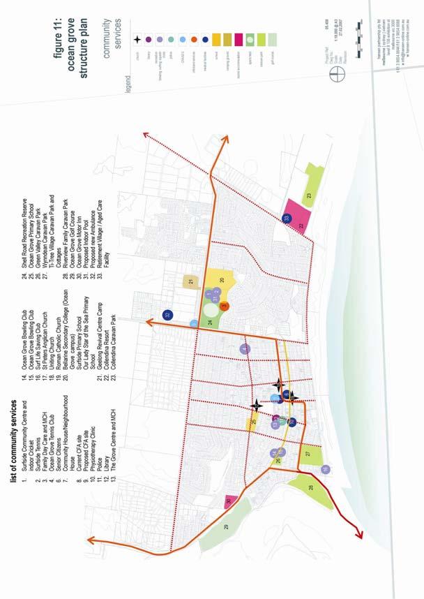
99 C-58
100 An increase in the provision of Council customer service centre services, library services, neighbourhood house services, and maternal and child health services; and The provision of aged care facilities within reasonable proximity of shops, public transport and community facilities. Emergency services Ocean Grove has excellent emergency service facilities which serve a regional role within the Bellarine and include: A 24hr staffed Police station in presidents Avenue adjacent to the town centre. A CFA station on the corner of Hodgson and The Avenue this site is to be vacated with CFA relocating to a site on the corner of Grubb and Shell roads which will better service their emergency response time targets. A new ambulance station located within the industrial estate off Grubb Road. Key Influences Basic infrastructure (drainage, water, sewerage, power, gas and telecommunications) is required to be provided in newly developed areas in a co-ordinated and staged manner and will involve augmentation of existing infrastructure. The design and appearance of the road network throughout the town will be instrumental in making Ocean Grove a safer, more attractive, cohesive and sustainable community. Social and community infrastructure including public transport services and accessible bus routes will need to be integrated into the urban area to meet current and future population needs, particularly the needs of the elderly and youth, with opportunities for co-location of facilities and multi-purpose facilities where possible. Accessibility and walkability considerations will influence the location of future social and community services and facilities in Ocean Grove. Opportunities exist to improve pedestrian and bicycle linkages throughout the town and within open spaces. Adequate provision for open space for both informal and formal recreation purposes needs to be designated to address the future recreational needs of the community. Beach access and facilities need to be improved and upgraded. Substantive drainage measures are needed to be put into place in new residential development to the north to minimise adverse stormwater drainage impacts on the nearby wetlands of Lake Victoria The funding of future infrastructure can be assisted by the preparation of a Developer Contributions Scheme. 7. Natural Environment Landscape and Topography The landscape and coastal setting of Ocean Grove provides edges to the town and shapes the direction of future development. To the south, the town overlooks the beach and the ocean with limited views due to the undulating topography and natural vegetation. The topography is steeply undulating and rises up to a high point to the north of the town where the water tank is located. A ridgeline forms an arc around the existing urban area and provides views to the sea and surrounding natural features. The natural vegetation to the north is a scattering of indigenous trees and grasses that reflect the harsh environment of sea breezes and coastal soils. To the west the Barwon River meanders through wetlands that create an open feature that divides Ocean Grove from Barwon Heads. The wetland provides a natural habitat for a variety of birds and wetland species and provides open views on approach to the town from the west. C-59
101 The domestic landscape features include well developed suburban gardens particularly in the north western and older parts of Ocean Grove. Street trees reflect native species that are informally planted especially in the older areas. Streetscape plantings have little consistency and provide an opportunity to further reinforce the seaside impression of the streetscape. Some existing stands of native trees, such as along Grubb Road, provide valuable natural features. Open Space and Biodiversity The Bellarine Recreation and Leisure Needs Study (2005) outlines the various recreation and open space issues that need to be addressed. These issues have been included in the structure plan and on corresponding plans. The study of open space networks primary recommendation is to acquire and develop Linear Linkage sites which allow improved pedestrian and cyclist movement within the town and between Ocean Grove and other towns in the district. It has been noted that there is a lack of open space in both Parks Estate and Kingston Estate and opportunities to provide additional open space need to be addressed. Ocean Grove is commonly recognised as an area with significant natural habitat and biodiversity. Specific strategies have been prepared for Lake Victoria and Buckley Park. The main concern relating to Lake Victoria is its frequent flooding experienced during prolonged periods of heavy rainfall. Buckley Park is noted for its significance to the community. The park will likely remain as an open space area and not become part of the recreational spaces of Ocean Grove. Active management of these natural assets is essential to ensure their use by future generations of Ocean Grove. Discussion Ocean Grove is acknowledged for its natural landscape, coastal setting, significant natural habitat and biodiversity and substantial range of recreational options. As these natural features make Ocean Grove one of the most attractive coastal towns in Greater Geelong, protection and management of these assets is fundamental to the town s future. However distinct gaps have been identified in relation to amenity and the provision of landscaping, informal parks and linear linkages. The landscaping and amenity improvements considered important to include creating a more consistent streetscape planting regime. This will assist in reinforcing the seaside nature of the town and beautify the pedestrian realm. Greater provision of informal parks and linear linkages is also required to improve pedestrian and cyclist movement within the town and between Ocean Grove and other towns in the district. New developments must also provide adequate open spaces to address the needs of future residents and maintain the landscape character of the town. Key influences Ocean Grove is bound by significant environmental features including the foreshore, Lake Connewarre (Barwon Estuary), Lake Victoria, Ocean Grove Nature Reserve and the Begola Wetlands. These and other natural features of the town need to be protected and enhanced, where appropriate. Whilst various environmental overlays currently protect the natural environmental assets of the town and environs, expansion of these overlays and, inclusion of some new overlays, will be necessary if the sensitive ecosystems of the area are to be protected. There is considerable scope for consolidation and expansion of the vegetation cover throughout the town thus reinforcing its coastal character and visual amenity. C-60
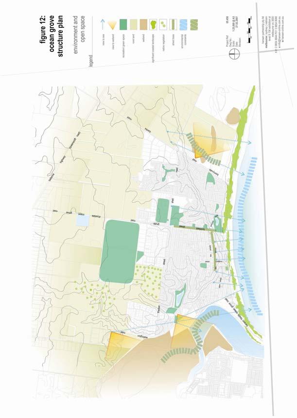
102 C-61
OCEAN GROVE STRUCTURE PLAN
 OCEAN GROVE STRUCTURE PLAN December 2015 1 WWW.GEELONGAUSTRALIA.COM.AU 2 Contents Part A Structure Plan 1 Introduction... 5 1.1 Purpose of the Structure Plan 5 1.2 How will this plan be used? 5 1.3 Plan
INCREMENTAL CHANGE AREA REVIEW March 2015 Page 1
 INCREMENTAL CHANGE AREA REVIEW March 2015 Page 1 Table of Contents Introduction... 3 Background to Review... 3 Comparison of the Schedules to the General Residential Zone... 7 Methodology... 7 Policy Context...
RE: AMENDMENT C375 GEELONG PLANNING SCHEME 1900 BARWON HEADS ROAD, BARWON HEADS
 Reference: #V157080 14 August 2018 Barwon Heads Lifestyle Group Pty Ltd C/- Best Hooper Lawyers Level 9, 451 Little Bourke Street MELBOURNE VIC 3000 Attention: Mr. Edward Mahony (Lawyer) Dear Edward RE:
Northern Territory Compact Urban Growth Policy
 Northern Territory Compact Urban Growth Policy A Reference Policy Document to clause 2.7 (Reference to Policy) of the NT Planning Scheme May 2015 Table of Contents 1 Policy Setting... 3 1.1 Context for
Tāhuhu whakaruruhau ā-taone The sheltering ridge pole
 B2. Tāhuhu whakaruruhau ā-taone - Urban growth and form B2.1. Issues Tāhuhu whakaruruhau ā-taone The sheltering ridge pole Auckland s growing population increases demand for housing, employment, business,
The Proposed Auckland Unitary Plan (notified 30 September 2013)
") 3 Business zones Introduction There are 10 business zones in the Unitary Plan: City Centre Metropolitan Centre Town Centre Local Centre Neighbourhood Centre Mixed Use General Business Business Park Light
3 Business zones Introduction There are 10 business zones in the Unitary Plan: City Centre Metropolitan Centre Town Centre Local Centre Neighbourhood Centre Mixed Use General Business Business Park Light
Contents of Part 6. Part 6 Zones
 Contents of Part 6 Part 6 Zones... 6-1 6.1 Preliminary... 6-1 6.2 Zone codes... 6-3 6.2.1 Low density residential zone code... 6-3 6.2.1.1 Application... 6-3 6.2.1.2 Purpose and overall outcomes... 6-3
PORT WHITBY COMMUNITY
 PORT WHITBY COMMUNITY SECONDARY PLAN UPDATE COMMUNITY IMPROVEMENT PLAN URBAN DESIGN GUIDELINES September 2015 DRAFT PROPOSED AMENDMENT NUMBER # to the Whitby Official Plan PURPOSE: The intent of this Amendment
Plan Modification to Chapter B2 of the Auckland Unitary Plan(AUP) Operative in part (15 November 2016)
 Operative in part (15 November 2016)") UNITARY PLAN UPDATE REQUEST MEMORANDUM TO FROM Phill Reid Linley Wilkinson DATE 25 September 2018 SUBJECT Plan Modification to Chapter B2 of the Auckland Unitary Plan(AUP) Operative in part (15 November
UNITARY PLAN UPDATE REQUEST MEMORANDUM TO FROM Phill Reid Linley Wilkinson DATE 25 September 2018 SUBJECT Plan Modification to Chapter B2 of the Auckland Unitary Plan(AUP) Operative in part (15 November
6 Growth Management Challenges and Opportunities
 6 Growth Management Challenges and Opportunities The Town has established a goal of attaining a 50% participation rate with respect to employment opportunities versus residential population. The Town s
4 RESIDENTIAL ZONE. 4.1 Background
 4 RESIDENTIAL ZONE 4.1 Background The residential areas within the City are characterised by mainly lowrise dwellings sited on individual allotments. Past architectural styles, settlement patterns and
I615. Westgate Precinct
 I615. Westgate Precinct I615.1. Precinct Description The Westgate Precinct is located approximately 18km west of the Auckland city centre. There are seven Sub-precincts in the Westgate Precinct: Sub-precinct
Appendix 1 Structure plan guidelines
 Appendix 1 Structure plan guidelines This appendix forms part of the regional policy statement [rps]. 1.1. Introduction Structure plans are an important method for establishing the pattern of land use
COMMUNITY ACTIONS for a SUSTAINABLE BARWON HEADS. February 2016
 COMMUNITY ACTIONS for a SUSTAINABLE BARWON HEADS February 2016 Acknowledgements Traditional Owners We acknowledge the traditional owners of this land and pay our respects to their elders past and present,
SECTION 2.4 URBAN DEVELOPMENT AND STRATEGIC URBAN DIRECTIONS
 SECTION 2.4 URBAN DEVELOPMENT AND STRATEGIC URBAN DIRECTIONS 2.4.1 INTRODUCTION In 1993/94 the Hastings District Council completed the Hastings Urban Development Strategy. The purpose of this study was:
DAREBIN PLANNING SCHEME AMENDMENT C137
 Who is the planning authority? Planning and Environment Act 1987 DAREBIN PLANNING SCHEME AMENDMENT C137 EXPLANATORY REPORT This amendment has been prepared by the Darebin City Council, who is the planning
DRYSDALE - CLIFTON SPRINGS STRUCTURE PLAN Prepared by the City of Greater Geelong Adopted September 2010
 DRYSDALE - CLIFTON SPRINGS STRUCTURE PLAN Prepared by the City of Greater Geelong Adopted September 2010 Table of Contents PART A STRUCTURE PLAN 1 1.0 Introduction... 1 1.1 Purpose of the Structure Plan...
Greater Geelong Planning Scheme Proposed Planning Scheme Amendment C and 5-19 Princes Highway, Norlane
 Greater Geelong Planning Scheme Proposed Planning Scheme Amendment C253 PLANNING SUBMISSION prepared for Bunnings Group Ltd by SJB Planning Pty Ltd Level 1, Building D 80 Dorcas Street SOUTHBANK VIC 3006
EAST VILLAGE STRATEGIC SITE NOVEMBER 2017
 EAST VILLAGE STRATEGIC SITE NOVEMBER 2017 East Village will be a sustainable, mixeduse precinct with a focus on innovative employment and education opportunities. Enhanced by green spaces and places for
Mollers Lane, Leopold, Victoria Significant Landscape Overlay Re-assessment
 XURBAN Mollers Lane, Leopold, Victoria Significant Landscape Overlay Re-assessment For: TGM Group November 2016 Final Mollers Lane, Leopold, Victoria Significant Landscape Overlay Re-assessment Client
THREE PARKS ZONE Three Parks Special Zone The process of applying for resource consents in the zone.
 .25 Three Parks Special Zone The purpose of this zone is to provide for growth and to give effect to the Wanaka 2020 Community (2002) and the more recent Wanaka Structure (2007) and Wanaka Transport Strategy
[PLANNING RATIONALE] For Site Plan Control and Lifting of Holding Zone By-Law 101 Champagne Avenue. May 23, 2014
![[PLANNING RATIONALE] For Site Plan Control and Lifting of Holding Zone By-Law 101 Champagne Avenue. May 23, 2014](/thumbs/75/71599615.jpg "[PLANNING RATIONALE] For Site Plan Control and Lifting of Holding Zone By-Law 101 Champagne Avenue. May 23, 2014") [PLANNING RATIONALE] For Site Plan Control and Lifting of Holding Zone By-Law 101 Champagne Avenue May 23, 2014 Contents 1.0 Introduction... 2 2.0 Site Context... 2 2.1 Adjacent Uses... 2 Figure 1: Site
[PLANNING RATIONALE] For Site Plan Control and Lifting of Holding Zone By-Law 101 Champagne Avenue May 23, 2014 Contents 1.0 Introduction... 2 2.0 Site Context... 2 2.1 Adjacent Uses... 2 Figure 1: Site
and services The protection and conservation of environmentally significant and sensitive natural heritage features and functions.
 6. Land Use 6.0 Preamble A healthy and livable city is one in which people can enjoy a vibrant economy and a sustainable healthy environment in safe, caring and diverse neighbourhoods. In order to ensure
RURAL ZONE - POLICY. Rural Zone Policy. Issue: Rural Environment. Ruapehu District Plan Page 1 of 8
 Rural Zone Policy RU2 RURAL ZONE - POLICY RU2.1 Introduction The natural resources of the rural environment in the Ruapehu District provide the basis for the existing and potential character, intensity
4.0 Zones and Overlays
 4.0 Zones and Overlays The following section details the existing zones and overlays within the Mooroopna West Growth Corridor. Revision 1 7 July 2009 Page 27 Due to the overall size (260 ha) and geographical
A Growing Community Rural Settlement Areas
 Town of Huntsville Official Plan Review - POLICY BACKGROUND PAPER A Growing Community Rural Settlement Areas BACKGROUND: In addition to the fully municipally-serviced Urban Settlement Area and the Hidden
PART 02 HASTINGS POINT IN CONTEXT
 PART 02 HASTINGS POINT IN CONTEXT 2.1 Background 2.1.1 Demographic Information 2.1.2 Existing Locality Characteristics 2.2 The Planning Framework 2.2.1 The Far North Coast Regional Strategy 2006 2.2.2
MAYFIELD WEST SECONDARY PLAN PHASE 2
 MAYFIELD WEST SECONDARY PLAN PHASE 2 Public Open House #3 February 25, 2010 Draft Preferred Land Use Scenario TOWN OF CALEDON PLANNING & DEVELOPMENT DEPARTMENT Open House Agenda TOWN OF CALEDON 1. Welcome
10.0 Open Space and Public Realm
 10.0 Open Space and Public Realm 10.0 Open Space and Public Realm The Public Open Space System is comprised of: outdoor spaces available for public use that are either publicly owned (e.g., parks and
Town of Cobourg Heritage Master Plan. Statutory Public Meeting
 Town of Cobourg Heritage Master Plan Statutory Public Meeting April 25 th 2016 Presentation Overview 1. Introduction 2. Project background and schedule overview 3. Review of strategic direction content
CITY OF FREMANTLE LOCAL PLANNING SCHEME NO. 4 AMENDMENT NO. 68 SCHEME AMENDMENT REPORT
 CITY OF FREMANTLE LOCAL PLANNING SCHEME NO. 4 AMENDMENT NO. 68 SCHEME AMENDMENT REPORT CITY OF FREMANTLE PLANNING AND DEVELOPMENT SERVICES 8 WILLIAM STREET FREMANTLE WA 6160 PLANNING AND DEVELOPMENT ACT
Newcourt Masterplan. November Exeter Local Development Framework
 Newcourt Masterplan November 2010 Exeter Local Development Framework Background The Exeter Core Strategy Proposed Submission sets out the vision, objectives and strategy for the development of Exeter up
GREENBANK DEVELOPMENT MASTERPLAN
 DEVELOPMENT MASTERPLAN POTENTIAL TRAIN STATION COMMUNITY CENTRE Greenbank will be a connected masterplanned community providing easy access to local and surrounding amenity. Affordable quality homes, green
LEOPOLD STRUCTURE PLAN. Prepared by the City of Greater Geelong September 2011 (Amended Jan 2013)
") LEOPOLD STRUCTURE PLAN Prepared by the City of Greater Geelong September 2011 (Amended Jan 2013) Table of Contents PART A STRUCTURE PLAN 1.0 Introduction... 3 1.2 How will this plan be used?... 3 1.3 Plan
LEOPOLD STRUCTURE PLAN Prepared by the City of Greater Geelong September 2011 (Amended Jan 2013) Table of Contents PART A STRUCTURE PLAN 1.0 Introduction... 3 1.2 How will this plan be used?... 3 1.3 Plan
Planning Proposal Charlestown Swim and Leisure Centre LEP Amendment
 Planning Proposal Charlestown Swim and Leisure Centre LEP Amendment Amendment No. 4 to Lake Macquarie Local Environmental Plan 2014 (PP_2014_LAKEM_005_00) Local Government Area: Name of Draft LEP: Lake
Woodbrook - Shanganagh
 Section 4: Key Sites Framework Strategy Woodbrook - Shanganagh Local Area Plan 2017-2023 4. Site Framework Strategies The Master Plans shall have regard to the thematic objectives under the LAP Development
WHITELEY TOWN COUNCIL NORTH WHITELEY DEVELOPMENT SEPTEMBER 2014
 WHITELEY TOWN COUNCIL NORTH WHITELEY DEVELOPMENT SEPTEMBER 2014 Dear Resident This Special Edition of the Whiteley Voice which has been prepared in conjunction with the North Whiteley Consortium is to
SCHEDULE THREE TO THE DEVELOPMENT PLAN OVERLAY EASTERN GOLF COURSE KEY REDEVELOPMENT SITE
 DD/MM/YY SCHEDULE THREE TO THE DEVELOPMENT PLAN OVERLAY Shown on the planning scheme map as DPO3 EASTERN GOLF COURSE KEY REDEVELOPMENT SITE 1.0 A permit may be granted before a development plan has been
BELLARINE PENINSULA Draft Localised Planning Statement JUNE 2014
 BELLARINE PENINSULA Draft Localised Planning Statement JUNE 2014 BELLARINE PENINSULA Draft Localised Planning Statement JUNE 2014 The Bellarine Peninsula Draft Localised Planning Statement has been developed
Welcome. Walk Around. Talk to Us. Write Down Your Comments
 Welcome This is an information meeting introducing the applications for proposed redevelopment of the Yorkdale Shopping Centre site at 3401 Dufferin Street and 1 Yorkdale Road over the next 20+ years,
STRATEGIC IMPLEMENTATION PANEL SUBMISSION
 STRATEGIC IMPLEMENTATION PANEL SUBMISSION AMENDMENT C375 to the GREATER GEELONG PLANNING SCHEME BARWON HEADS STRUCTURE PLAN IMPLEMENTATION Part A Submission to the Independent Panel Panel: Con Tsotsoros
Land Use Amendment in Southwood (Ward 11) at and Elbow Drive SW, LOC
 at and Elbow Drive SW, LOC") 2018 November 15 Page 1 of 10 EXECUTIVE SUMMARY This land use amendment application was submitted by Rick Balbi Architect on 2017 August 31 on behalf of Sable Developments Ltd, and with authorization from
2018 November 15 Page 1 of 10 EXECUTIVE SUMMARY This land use amendment application was submitted by Rick Balbi Architect on 2017 August 31 on behalf of Sable Developments Ltd, and with authorization from
ELMVALE ACRES SHOPPING CENTRE MASTER PLAN
 ELMVALE ACRES SHOPPING CENTRE MASTER PLAN Contents 1.0 INTRODUCTION... 2 2.0 LOCATION... 2 3.0 EXISTING CONTEXT... 2 4.0 VISION & GUIDING PRINCIPLES... 2 5.0 LAND USE AND BUILT FORM... 4 5.1 St. Laurent
REMARKABLES PARK ZONE
 .10 Remarkables Park Zone.10.1 Resources, Activities and Values The Remarkables Park Area comprises approximately 150 hectares of perimeter urban land in the vicinity of Frankton and occupies a strategic
TABLE OF CONTENTS. Human Habitats, 155 Dorcas St South Melbourne, Victoria 3205
 TARNEIT JUNCTION Town Planning Report DECEMBER 2013 TABLE OF CONTENTS Table of contents... 1 1 Introduction... 2 2 SIte context and surrounds... 4 2.1 Site Features... 4 2.2 Surrounding land uses... 4
QUEENSTOWN LAKES DISTRICT COUNCIL SUBDIVISION DESIGN GUIDELINES
 Attachment C: Draft QLDC Subdivision Design Guidelines QUEENSTOWN LAKES DISTRICT COUNCIL DESIGN GUIDELINES A DESIGN GUIDE FOR AND DEVELOPMENT IN THE URBAN ZONES QUEENSTOWN OFFICE 10 Gorge Road Queenstown
14.5 HOPEFIELD: (REFER PLAN 39 AND PLAN 40)
") URBAN DYNAMICS WESTERN CAPE INC. 248 14.5 HOPEFIELD: (REFER PLAN 39 AND PLAN 40) FIGURE 83: LOCALITY - HOPEFIELD Within the context of the Saldanha Bay Municipal area, Hopefield, an historical agricultural
URBAN DYNAMICS WESTERN CAPE INC. 248 14.5 HOPEFIELD: (REFER PLAN 39 AND PLAN 40) FIGURE 83: LOCALITY - HOPEFIELD Within the context of the Saldanha Bay Municipal area, Hopefield, an historical agricultural
Combined Planning Scheme Amendment Request and Planning Permit Application
 Combined Planning Scheme Amendment Request and Planning Permit Application Rezone land from the Farming Zone to the Commercial 1 Zone and develop a SubRegional Activity Centre Bellarine Gateway Plaza,
Planning Proposal Concurrent DA/LEP Amendment for Belmont North Pharmacy Amendment No. 24 to Lake Macquarie Local Environmental Plan (LMLEP) 2014
 2014") Planning Proposal Concurrent DA/LEP Amendment for Belmont North Pharmacy Amendment No. 24 to Lake Macquarie Local Environmental Plan (LMLEP) 2014 Local Government Area: Name of Draft LEP: Subject Land:
Planning Proposal Concurrent DA/LEP Amendment for Belmont North Pharmacy Amendment No. 24 to Lake Macquarie Local Environmental Plan (LMLEP) 2014 Local Government Area: Name of Draft LEP: Subject Land:
Complete Neighbourhood Guidelines Review Tool
 Complete Neighbourhood Guidelines Review Tool Prepared By: City of Regina Planning Department October 2014 Page 1 of 14 Community Development Review Checklist for Secondary Plans and Concept Plans The
APPENDIX 1 - OCEAN GROVE SIGNIFICANT TREE PROJECT SIGNIFICANT TREE AREA DEVELOPMENT PATTERNS 1960 S TO 2013
 APPENDIX 1 - OCEAN GROVE SIGNIFICANT TREE PROJECT SIGNIFICANT TREE AREA DEVELOPMENT PATTERNS 1960 S TO 2013 1966 1977 APPENDIX 1 - OCEAN GROVE SIGNIFICANT TREE PROJECT 1984 1990 APPENDIX 1 - OCEAN GROVE
Chapter 2: OUTLINE PLANNING APPLICATION PROPOSALS. A New Garden Neighbourhood Matford Barton 17
 Chapter 2: OUTLINE PLANNING APPLICATION PROPOSALS A New Garden Neighbourhood Matford Barton 17 2.1. SUMMARY AND STATUS OF THE PROPOSALS 2.1.1. The parameter plans and associated wording in this chapter
HOROWHENUA DEVELOPMENT PLAN June create a safe crossing for children moving to and from the school and other areas. 7.8 Ohau
 7.8 Ohau create a safe crossing for children moving to and from the school and other areas. Ohau has a traditional village form with a collective of school, church and reserve at the main road intersection.
Sustainable Growth. Sustainable Growth
 2 Sustainable Growth Sustainable Growth SUSTAINABLE GROWTH 2.1 COMMUNITY VISION... 2-5 2.2 THE CITY SYSTEM... 2-7 2.2.1 AREAS... 2-7 2.2.2 CITY-WIDE SYSTEMS... 2-8 2.2.3 PROVINCIAL PLAN BOUNDARIES AND
2A District-wide Policies
 2A Introduction This Chapter contains policies which are relevant to subdivision, use and development activities occurring across all zones and areas of the District. The policies in this Chapter implement
4.1.3 LAND USE CATEGORIES
 4.1.3 LAND USE CATEGORIES a. City Center District The City Center District incorporates the existing character and mix of uses in downtown Belmont to encourage redevelopment and new development in keeping
Draft Eastern District Plan
 Draft Eastern District Plan Submission_id: 31238 Date of Lodgment: 13 Dec 2017 Origin of Submission: Online Organisation name: Turrulla Gardens Pty Ltd C/- Mecone Organisation type: Industry First name:
AOTEA SUPERMARKET ZONE. Zone Introduction
 C18 AOTEA SUPERMARKET ZONE Zone Introduction C18.1 Objective This zone identifies a specific area in Aotea for a stand alone supermarket. The zone is site specific and has a range of objectives, policies
I609. Penihana North Precinct
 I609. Penihana North Precinct I609.1. Precinct description The Penihana North Precinct is located south of the Swanson Railway Station, adjacent to the Rural Urban Boundary (RUB) and Waitakere Ranges Heritage
Schedule of Planning Applications Committee Date: 23 May Reference: 06/17/0726/F Parish: Hemsby Officer: Mr J Beck Expiry Date:
 Schedule of Planning Applications Committee Date: 23 May 2018 Reference: 06/17/0726/F Parish: Hemsby Officer: Mr J Beck Expiry Date: 22-05-2018 Applicant: Proposal: Site: Mr Gillett Change of use to the
YONGE STEELES CORRIDOR SECONDARY PLAN. Young + Wright / IBI Group Architects Dillon Consulting Ltd. GHK International (Canada) Ltd.
 Ltd.") PART A: PREAMBLE 1.0 PURPOSE The purpose of this Secondary Plan is to provide a development framework for intensification of the Yonge/ Steeles corridor including the north side of Steeles Avenue West
PART A: PREAMBLE 1.0 PURPOSE The purpose of this Secondary Plan is to provide a development framework for intensification of the Yonge/ Steeles corridor including the north side of Steeles Avenue West
Rochford District Council Allocations Development Plan Document: Discussion and Consultation Document Sustainability Appraisal
 Option SWH1 Balanced Communities Option SWH1 1 To ensure the delivery of high quality sustainable communities where people want to live and work Will it ensure the phasing of infrastructure, including
Part 10 Other plans
 Contents of Part 10 Part 10 Other plans... 10-1 10.1 Preliminary... 10-1 10.2 Palmview Structure Plan... 10-2 10.2.1 Preliminary... 10-2 10.2.2 Master Strategic Framework... 10-6 10.2.3 Master Precincts
elbridge Core Strategy
 C elbridge Core Strategy Celbridge is designated as a Moderate Growth Town in the RPGs. The County Development Plan reinforces this designation in its settlement strategy. Moderate Growth Towns within
1.0 Purpose of a Secondary Plan for the Masonville Transit Village
 Report to Planning and Environment Committee To: Chair and Members Planning & Environment Committee From: John M. Fleming Managing Director, Planning and City Planner Subject: Masonville Transit Village
CASEY PLANNING SCHEME AMENDMENT C188
 Who is the planning authority? Planning and Environment Act 1987 CASEY PLANNING SCHEME AMENDMENT C188 EXPLANATORY REPORT This amendment has been prepared by the Growth Areas Authority (now known as the
141 GEORGE STREET PLANNING RATIONALE
 141 GEORGE STREET PLANNING RATIONALE MINOR ZONING BY-LAW AMENDMENT NOVEMBER 2, 2016 PLANNING RATIONALE 223 McLeod Street Ottawa, ON K2P 0Z8 613.730.5709 fotenn.com INTRODUCTION FOTENN Consultants is acting
Woodburn Comprehensive Plan Growth Management Goals and Policies
 Goal Woodburn Comprehensive Plan Growth Management Goals and Policies G-1. The City's goal is to manage growth in a balanced, orderly and efficient manner, consistent with the City s coordinated population
The West Vaughan Employment Area Secondary Plan Policies
 Part 2: The West Vaughan Employment Area Secondary Plan Policies 2.1 General Policies It is the policy of Council: 2.1.1. That the West Vaughan Employment Area (the WVEA), identified on Schedule 1, will
Keystone Business Park Precinct Structure Plan North East Industrial Precinct. Part 2 Design Principles
 Keystone Business Park Precinct Structure Plan North East Industrial Precinct Part 2 Design Principles Context Issues Services Landform Issues Geotech and contamination Ecology Traffic and access Issues
6 PORT SYDNEY SETTLEMENT AREA
 Section 6 Port Sydney Page 61 6 PORT SYDNEY SETTLEMENT AREA 6.1 Basis and Principles Village of Port Sydney Waterfront Community Existing Services 6.1.1 Port Sydney is an historic settlement that has developed
Ensure that development within the Arrowtown Urban Growth Boundary provides:
 URBAN DEVELOPMENT 4 4.2.5.2 Ensure that development within the Arrowtown Urban Growth Boundary provides: an urban form that is sympathetic to the character of Arrowtown, including its scale, density, layout
Draft Western District Plan
 Powered by TCPDF (www.tcpdf.org) Draft Western District Plan Submission_id: 31440 Date of Lodgment: 15 Dec 2017 Origin of Submission: Online Organisation name: Goodman Property Services Australia Pty Ltd
COMMUNITY DESIGN. GOAL: Create livable and attractive communities. Intent
 COMMUNITY DESIGN Intent An attractive, well-designed County will attract quality development, instill civic pride, improve the visual character of the community, and create a strong, positive image for
DRAFT FOR YOUR FEEDBACK DRAFT LOGAN RESERVE PLAN
 DRAFT FOR YOUR FEEDBACK CONTENTS INTRODUCTION... BACKGROUND... State Government... Council... PLANNING LEGISLATION AND RULES... CONSULTATION PROCESS...... ENVIRONMENT AND CONSERVATION... HOUSING... Proposed
STRATEGIC DIRECTION. QLDC PROPOSED DISTRICT PLAN [PART TWO] DECISIONS VERSION 3 strategic direction
![STRATEGIC DIRECTION. QLDC PROPOSED DISTRICT PLAN [PART TWO] DECISIONS VERSION 3 strategic direction](/thumbs/79/79711764.jpg "STRATEGIC DIRECTION. QLDC PROPOSED DISTRICT PLAN [PART TWO] DECISIONS VERSION 3 strategic direction") 3 STRATEGIC DIRECTION QLDC PROPOSED DISTRICT PLAN [PART TWO] DECISIONS VERSION 3 strategic direction QLDC DISTRICT PLAN [PART TWO] AUGUST 2015 3 strategic direction 3.1 Purpose This chapter sets out the
3 STRATEGIC DIRECTION QLDC PROPOSED DISTRICT PLAN [PART TWO] DECISIONS VERSION 3 strategic direction QLDC DISTRICT PLAN [PART TWO] AUGUST 2015 3 strategic direction 3.1 Purpose This chapter sets out the
CANOPY AT AMSTEL (THE AMSTEL GOLF COURSE REDEVELOPMENT)
") CANOPY AT AMSTEL (THE AMSTEL GOLF COURSE REDEVELOPMENT) 1000 CRANBOURNE FRANKSTON ROAD, CRANBOURNE The former Amstel Golf Course was rezoned to a General Residential Zone in 2015 to facilitate its redevelopment
CANOPY AT AMSTEL (THE AMSTEL GOLF COURSE REDEVELOPMENT) 1000 CRANBOURNE FRANKSTON ROAD, CRANBOURNE The former Amstel Golf Course was rezoned to a General Residential Zone in 2015 to facilitate its redevelopment
Official Plan Review
 Official Plan Review Summary Report - The Built Environment August 2014 Part 1: Introduction Planning for a healthy, prosperous and sustainable community is an important goal for our municipality. From
CITY VIEW OBJECTIVES
 SECTION 2: CITY VIEW OBJECTIVES CONTENTS 2.1 Introduction 1 2.2 Strategic Direction 1 2.3 The City View Resource Management Issues for the City 1 2.4 The Goal 3 2.5 The City View Objectives 3 Palmerston
Urban Design Brief. Watson Parkway North & Watson Road North Guelph, Ontario. Prepared by Coletara Development
 Urban Design Brief Watson Parkway North & Watson Road North Guelph, Ontario Prepared by Coletara Development December, 2013 Urban Design Brief, Coletara Development 1 Introduction This Urban Design Brief
LARA STRUCTURE PLAN Prepared by the City of Greater Geelong Adopted April 2011
 LARA STRUCTURE PLAN Prepared by the City of Greater Geelong Adopted April 2011 PART A STRUCTURE PLAN...5 1.0 Introduction...5 1.1 Purpose of the Structure Plan...5 1.2 How will this plan be used?...5
Integrated Urban Structuring in Australia An Overview of Principles and Practice
 ACNU08 Brisbane Integrated Urban Structuring in Australia An Overview of Principles and Practice Wendy Morris Ecologically Sustainable Design Pty Ltd Melbourne, Australia esdesign@netspace.net.au Ecologically
13 THORNHILL YONGE STREET STUDY IMPLEMENTATION CITY OF VAUGHAN OPA 669 AND TOWN OF MARKHAM OPA 154
 13 THORNHILL YONGE STREET STUDY IMPLEMENTATION CITY OF VAUGHAN OPA 669 AND TOWN OF MARKHAM OPA 154 The Planning and Economic Development Committee recommends the adoption of the recommendations contained
SECTION ONE North East Industrial Zone Design Guide Palmerston North City Council June 2004
 SECTION ONE North East Industrial Zone Design Guide Palmerston North City Council June 2004 young heart easy living 1 Preface Industrial areas are a very important component of the economic well-being
ELLIOTT HEADS STRUCTURE PLAN
 ELLIOTT HEADS STRUCTURE PLAN BACKGROUND This report has been prepared to provide an overview of the land that has been included in the Urban Footprint within the Wide Bay Burnett Regional Plan, September
WATERFORD Plan of Preservation, Conservation and Development Supplement Part 1 - Policy Element
 WATERFORD 2012 Plan of Preservation, Conservation and Development 2015 Supplement Part 1 - Policy Element Effective June 11, 2015 2015 Plan Update GOAL To respond to the evolving land use needs and continually
22.15 OUTDOOR ADVERTISING SIGNAGE POLICY
 22.15 OUTDOOR ADVERTISING SIGNAGE POLICY This policy applies to all land where a planning permit is required to construct or display a sign under the provisions of the Kingston Planning Scheme. 22.15-1
I539. Smales 2 Precinct
 I539. Smales 2 Precinct I539.1. Precinct Description The Smales 2 Precinct applies to a 4.8 hectare block of land located on the southern side of Northcote Road and fronting Lake Pupuke, Takapuna. The
Edward R. Sajecki Commissioner of Planning and Building
 Corporate Report Clerk s Files Originator s Files CD.03.POR DATE: TO: FROM: SUBJECT: Chair and Members of Planning and Development Committee Meeting Date: February 27, 2012 Edward R. Sajecki Commissioner
Summary of strategic directions
 Summary of strategic directions The overall project has complexities of land use within the green wedge and industrial zones. Also, the local councils strategic vision is to develop more integrated open
Appendix C: Interim Mixed-Use Evaluation Criteria
 Appendix C: Interim Mixed-Use Evaluation Criteria C-1 Appendix C: Interim Mixed-Use Evaluation Criteria PURPOSE: The implementation of numerous policies contained within the Master Plan hinges on the creation
City of Grande Prairie Development Services Department KENNEDY DEVELOPMENTS LTD. OUTLINE PLAN OP-09-01
 City of Grande Prairie Development Services Department KENNEDY DEVELOPMENTS LTD. OUTLINE PLAN OP-09-01 July 27, 2009 TABLE OF CONTENTS 1.0 Introduction... 1 1.1 Plan Area Location & Context... 1 1.2 Ownership
Page 1 of 19 URBAN DESIGN FRAMEWORK FOR BOLTON STREET WATERFORD
 Page 1 of 19 URBAN DESIGN FRAMEWORK FOR BOLTON STREET WATERFORD 1.0 Introduction: The relocation of the City Council stores and depot from Bolton Street creates an exciting opportunity for development
GATEWAY AREA STRUCTURE PLAN
 CHESTERMERE GATEWAY AREA STRUCTURE PLAN COMMUNITY OPEN HOUSE SEPTEMBER 22 nd, 2015 PLAN AREA ± 512 hectares (± 1,265 acres) GATEWAY LOCATION UNDEVELOPED LANDS PRESENT AGRICULTURAL USE REGIONAL LAND USE
URBAN DESIGN BRIEF URBAN DESIGN BRIEF 721 FRANKLIN BLVD, CAMBRIDGE August 2018
 URBAN DESIGN BRIEF URBAN DESIGN BRIEF 721 FRANKLIN BLVD, CAMBRIDGE August 2018 DESIGN BRIEF CONTENTS PART A 1.0 INTRODUCTION 2.0 DESCRIPTION & ANALYSIS OF SITE CONTEXT 3.0 DESIGN CONSTRAINTS AND OPPORTUNITIES
LUNDY S LANE COMMUNITY IMPROVEMENT PLAN STUDY
 PUBLIC INFORMATION MEETING #2 October 12, 2016 LUNDY S LANE COMMUNITY IMPROVEMENT PLAN STUDY AGENDA 5:00 to 5:30pm: Open House 5:30 to 6:15pm: Presentation 6:15 to 7:00pm: Individual paced workshop with
This page has been intentionally left blank.
 This page has been intentionally left blank. Chapter 3 3-2 3. Employment 3.A Niagara Economic Gateway 3.A.1 General The Niagara Economic Gateway comprises: a) The Gateway Economic Zone which includes all
The Five Components of the McLoughlin Area Plan
 The Five Components of the McLoughlin Area Plan This documents contains the complete language of the five components of the McLoughlin Area Plan: The Vision Statement The Values The Guiding Principles
CONTENTS 8.0 LAND USE 8.1 GENERAL LAND USE 8.2 RESIDENTIAL 8.3 MIXED USE 8.4 COMMERCIAL 8.5 EMPLOYMENT LANDS
 8-2 Land Use 8.0 LAND USE CONTENTS 8.1 GENERAL LAND USE 8.1.1 Uses provided for in all Land Use Designations 8.1.2 Uses prohibited in Hazardous Lands, Hazardous Sites and Special Policy Areas 8.1.3 Uses
Westwind Developments Ltd. PIONEER LANDS AREA STRUCTURE PLAN - PROPOSED AMENDMENT
 FEBRUARY 2013 TABLE OF CONTENTS 1.0 BACKGROUND... 1 1.1 Amendment... 1 2.0 LOCATION & CONTEXT... 2 2.1 Land Ownership... 2 3.0 POLICY CONTEXT... 3 3.1 Municipal Development Plan... 3 3.2 Capital Region