Document Quality Assurance
|
|
|
- Gyles Anthony
- 6 years ago
- Views:
Transcription


1 Technical Report -


2 Document Quality Assurance Bibliographic reference for citation: Boffa Miskell Limited 2014: Northern Growth Area Structure Plan Technical Report prepared by Boffa Miskell Limited and Aurecon Limited for Porirua City Council. Prepared by: Reviewed by: Hamish Wesney, Senior Planner Chris Duffy, Senior Urban Designer Boffa Miskell Limited Haden Walters, Civil Engineer Aurecon Limited Stephen Fuller Senior Ecologist/Director Marc Baily, Urban Planner/Director Boffa Miskell Limited Status: FINAL Issue date: 28 November 2014 FINAL Template revision:
3 Contents Executive Summary Introduction Background Purpose of a Structure Plan Structure Plan Area Structure Plan Methodology Vision, Objectives and Development Principles Vision Key Objectives Development Principles Context Analysis Projected Population and Housing Statutory and Planning Context Key Issues, Opportunities and Constraints Development Options Development Scenarios Evaluation of Scenarios Structure Plan Overview Structure Plan Approach Key Aspects of the Structure Plan Structure Plan Staging Structure Plan Detail Land Use Movement Infrastructure Natural, Heritage and Cultural Values Hazards Implementation Statutory Planning Infrastructure Open Spaces/Reserves 66
4 7.4 General References 70 Appendices Appendix 1: Development Principles Appendix 2: Constraints and Opportunities Maps Appendix 3: Structure Plan Key Features
5 Executive Summary This Northern Growth Area (NGA) Structure Plan provides a high level spatial plan, as well as a set of investigation and management actions to guide the area s development for the next 20+ years. It provides for some 1,800 households in new residential areas, rural residential enclaves and a village centre within a framework of open space and ecological corridors all of which are connected by a network of streets, walking and cycling paths. The location and form of development, as well as the provisions to manage stormwater, have been carefully planned to protect the ecological and landscape values of the Taupo Swamp, wetlands and Pauatahanui Inlet. The density of residential development will be encouraged to be varied to take advantage of the opportunities for higher density where topography allows, open space provides a setting for development, and places like at the village centre where a node of various activities is anticipated. The Structure Plan has been influenced by the Porirua Development Framework and Regional plans and strategies such as the Wellington Regional Strategy and the Regional Land Transport Strategy. Implementation of the Structure Plan will be reliant on changes to the District Plan with management of new public infrastructure included in Council s asset management plans. Key recommendations include Council drafting a District Plan change to enable a mix of rural residential, residential, future local shops, open space networks and management areas of landscape and ecological values to be provided for. The main areas of residential development are within three development areas: Pukerua Bay West, Camborne North, and New Village. The plan change will provide a tiered spatial planning approach. The Structure Plan provides guidance to Comprehensive Development Plans (CDP) in which further detail of housing densities, roading networks, open spaces, protected areas, and services will be provided for at a neighbourhood scale. These CDP would require approval of Council. Subsequent subdivision plans at an individual street scale would show details of lot boundaries, easements and cadastral information in accordance with the CDP. The provision for stormwater management requires a catchment management planning process. This requirement should be undertaken as part of the CDP process to guide the density of development and range of stormwater management methods that should be applied in each development area. A new village area will, in time, provide for small local shops, open space reserve, shared with a new primary school. Provision for smaller lots and town house density development around this central area are an opportunity. There is capacity within the existing road network for development in the Camborne North Development area to proceed before the Transmission Gully Motorway is operational. Some land areas at the north of the NGA will be deferred from development until after 2031 as they are not required to meet anticipated demand for housing until after this time. Following adoption of the final Structure Plan a district plan change will be prepared and associated design guide and Section 32 assessment. This step will begin the more formal statutory process. There are a number of implementation actions required to give effect to the Structure Plan and these will be undertaken by Council, stakeholders and private developers with a short or medium to long term time frame. Northern Growth Area Structure Plan Technical Report 3
6 1.0 Introduction The purpose of this report is to document the background and details of the Structure Plan for Porirua s Northern Growth Area, which has been identified as a key strategic planning exercise in the Porirua City Council s 2009 Porirua Development Framework. The Structure Plan proposes a spatial pattern for the future growth and development of the Northern Growth Area. The scale, nature and location takes into account the projected housing demand and recognises and responds to the area s environmental qualities, infrastructure requirements and community values. The Structure Plan area mainly relates to the existing rural area north of Camborne and south of Pukerua Bay. In addition, this project considers intensification of the neighbouring suburban areas of Camborne, Mana and Plimmerton. There are also implications for upgrading the level of service of some roads and services outside the Structure Plan area. The Structure Plan has been informed by an assessment of a range of opportunities and constraints in this area. In addition the Structure Plan is based on an evaluation of different development scenarios and the benefits and costs of these scenarios. The Structure Plan for the Northern Growth Area project will inform the review of the Porirua District Plan for this area. This review may result in re-zoning land and applying appropriate provisions for the Structure Plan area. These provisions will then become the basis on which the Council will make planning decisions on future development in the area. In addition, infrastructure planning and expenditure associated with such future development would be incorporated in the Council s various Asset Management Plans and Long Term Plan (LTP), including information on possible Development Contributions for the Northern Growth Area. 1.1 Background The Porirua Development Framework outlines a broad strategy for managing the nature, location and structure of development for Porirua City for the next 20 years (and beyond). The Development Framework was prepared with community consultation and a spatial plan (called Framework Map ) was prepared for the city identifying the indicative location of development areas and forms. Within the Framework document, specific strategic study areas were identified where significant change was anticipated. The Northern Growth Area is one of the strategic study areas and below is a summary of the key points relating to this area to be addressed: The area has desirable characteristics for future urban growth, being located on State Highway 1, with proximity to a well developed local centre, community facilities and easy access to rail and the coast. Transmission Gully Motorway is also likely to change the relative use of Mana Esplanade. The area also faces development challenges related to the capacity of its infrastructure, the management of its amenity, and its exposure to natural hazard risks. 4 Northern Growth Area Structure Plan Technical Report
7 Potential rural residential east of the urban growth area north of Camborne considering: o o o o The management of amenity, including landscapes; The effects on the Porirua Harbour (including Pauatahanui Inlet); Servicing and infrastructure (including roads and transportation networks and community facilities); and Exposure to natural hazards. To implement this strategic direction, the Framework document included an action plan. One of the actions (Ref PP3) was to undertake a Mana/Plimmerton/Camborne Future Development Study (i.e. this project). 1.2 Purpose of a Structure Plan The Ministry for the Environment defines a Structure Plan as a high-level plan that shows the arrangement of land-use types, and identifies public infrastructure, such as streets, schools, rail, reservoirs and natural features.. The Structure Plan s purpose is to consider how existing and future development in the Northern Growth Area should be integrated to ensure efficient use of land and natural and physical resources. The Northern Growth Area Structure Plan is intended to be strategic and to provide a high level vision and long term focus, identifying principles for the future development of the area, whilst ensuring that it is achievable and realistic. The Structure Plan does not provide a detailed plan for the area; more detailed planning will follow through the development of individual plans (Comprehensive Development Plans) for sub-areas. Another purpose for developing the Structure Plan has been the need to investigate and plan the overall servicing and transportation requirements for the area in order to coordinate and establish parameters for the provision of infrastructure and services, the estimated costs of such facilities and a process for recovering investment costs. 1.3 Structure Plan Area The Porirua Development Framework Map in Figure 1-1 below shows the indicative location and extent of the Northern Growth Area. This study area includes the existing urban areas of Mana, Camborne and Plimmerton (eastern side only), the business/industrial area north of Camborne/Plimmerton (referred to as Plimmerton Estate ), and rural land between Camborne/Plimmerton and Pukerua Bay. The extent of the Structure Plan area shown in Figure 1-2 is generally based on catchment and property boundaries. Effectively this area equates to the catchment of the Taupo Swamp and Stream, with a small part draining to Pauatahanui Inlet. The western and northern boundary follows the ridgeline of the Wairaka hills and the eastern boundary effectively follows the ridge of the Kakaho hills. The north-eastern boundary is the southern edge of the Pukerua Bay urban area and the southern boundary is the northern end of Camborne and Plimmerton. Northern Growth Area Structure Plan Technical Report 5


8 Figure 1-1: Porirua Development Framework Map with Northern Growth Area shown with red outline 6 Northern Growth Area Structure Plan Technical Report


9 Figure 1-2: Northern Growth Area Structure Plan - Project Area Northern Growth Area Structure Plan Technical Report 7
10 1.4 Structure Plan Methodology The preparation of the Structure Plan followed four phases: Phase 1: Issues, Opportunities and Constraints site analysis, understanding policy direction and initial landowner and community consultation (this phase/report) Phase 2: Development Options scoping and evaluating developments, including testing and obtaining feedback from the community Phase 3: Draft Structure Plan preparing a preferred development option and implementation requirements and incorporating into a single document and plan Phase 4: Final Structure Plan a formal consultation process to consider and finalise the Structure Plan document Each phase has involved input and consultation with a range of parties, including key landowners, businesses, central and local government agencies, interested organisations, and Council staff and Councillors and members of the public. This input and consultation has informed the Structure Plan to enable it to align with community expectations. The format of this Technical Report document is based on the four phases of preparing the Structure Plan. Background to the structure planning process is established initially along with the vision, key objectives and principles for the Northern Growth Area. The Context Analysis provides a view of the statutory and planning framework along with a summary of the key issues, opportunities and constraints that influence the plan. The evaluation of the development options is summarised. The key output of the structure planning process is the map that shows graphically how the key features of the plan for future development are documented, which will inform future decisionmaking in implementing the Structure Plan. The final section identifies the actions to implement the Structure Plan including staging. 8 Northern Growth Area Structure Plan Technical Report
11 2.0 Vision, Objectives and Development Principles 2.1 Vision The vision for the Porirua Northern Growth Area is derived from a synthesis of the key themes that have come from site analysis, community feedback and urban planning principles. These themes are specifically referenced in the key objectives below: The development of the Porirua Northern Growth Area creates areas of distinctive character that reflect the sensitive environmental context, are responsive to topography and provide a range of housing options connected internally and externally by a network of open spaces, active transport modes, public transport routes and a hierarchy of roads. 2.2 Key Objectives The objective sought from the Structure Plan is sustainable, integrated and coordinated urban and rural development. In particular, the Structure Plan seeks to ensure the following: Integrated land use and infrastructure development patterns with a network of connections for vehicles, cycles and pedestrians, and ensuring that links to the wider network are efficiently and safely developed Scale, form and intensity of development responds to the supporting capacity of the natural and physical resources, including infrastructure, landscape and ecological values Future development complements the existing urban areas and does not detract from their special qualities or degrade their infrastructure Protection of the sensitive receiving environment and areas of significant indigenous biodiversity, including Taupo Swamp (which is recognised as an Outstanding Natural Feature), Pauatahanui Inlet and coastal marine areas Efficient planning of services to meet the likely long term needs of housing and industry within the area Support for development that is affordable and economic in the short and long term for both Council and the community 2.3 Development Principles The objectives identified above are further defined through a range of principles, which are intended to guide the progressive development of the Structure Plan on the ground. These principles set the high level requirements which future development proposals should give effect to. The full list of principles is in Appendix 1 and cover the following topics: Regional/City Context Economic Identity Transportation and Movement Northern Growth Area Structure Plan Technical Report 9
12 Services Infrastructure Environment Heritage Open Space Social 10 Northern Growth Area Structure Plan Technical Report
13 3.0 Context Analysis The Northern Growth Area is located in Porirua City on the main transport (road and rail) between Wellington City and the Kapiti Coast. The area is currently a rural (farming) area separating the established urban areas (villages) of Pukerua Bay and Plimmerton/Camborne. The context for the Structure Plan, particularly issues, opportunities and constraints are contained in an earlier report (Issues, Opportunities and Constraints for the Northern Growth Area Structure Plan). A summary of the main points of that earlier report is set out below. 3.1 Projected Population and Housing Porirua City s current population (2013) is 51,717 people residing in 18,069 households. In the Northern Growth Area, the current population is approximately 7,800 people residing in approximately 2,900 households. The City s population is projected to increase by between 3,400-9,600 people in the next 20 years. City-wide the number of new dwellings in the next 20 years is projected to be 4,000 5,000. Taking into account the overall nature and location of new development in the city for the Northern Growth Area, the estimated population and housing growth projections for this area are 2,800 4,600 additional people and 1,200 2,000 new dwellings. 3.2 Statutory and Planning Context As outlined above, the 2009 Porirua Development Framework is a long term spatial plan for physical growth and development for Porirua City as a whole. This Framework aims to plan for future growth and development in a holistic and integrated manner, including the planning and delivery of infrastructure and other services. This Framework specifically identifies the Northern Growth Area (the Structure Plan area) as a location for future urban (residential) development, possible long-term business/industrial development and rural-residential development in the medium-to-long term. The Framework contains a specific action to prepare a future development study for the Northern Growth Area (i.e. this project). Statutory documents (including the Wellington Regional Policy Statement and Porirua City District Plan) set out the overall policies and direction for development and subdivision in the region and city as a whole. These documents provide direction on urban form, design and function for new development and subdivision, amongst a range of other matters. Similarly, the Wellington Regional Strategy includes a focus area of good regional urban form. In addition, there are a number of other statutory and non-statutory documents which influence or are relevant considerations in preparing the Structure Plan. These documents include various strategies (e.g. land transport, landscape management, Porirua Harbour and Catchment) and plans (e.g. Asset Management Plans and Village Plans). 3.3 Key Issues, Opportunities and Constraints An analysis of the key issues, constraints and opportunities within the Northern Growth Area has been summarised in the table below which the Structure Plan aims to address. Northern Growth Area Structure Plan Technical Report 11
14 Table 3-1: Summary of Issues, Opportunities and Constraints Item Land Use and Characteristics Geology and Geotechnical Hazards Transportation Rural area Urban areas Business/service areas Geology Ground shaking and fault rupture Liquefaction Stability Sea Level Rise/Storm Surge/Tsunami Flooding Road State Highway 1 Opportunities and Constraints Large area of rural land suitable for greenfield development. A number of gullies, wetlands and steep land pose constraints to development. Intensification of existing urban areas provides an opportunity to support existing town centres, transportation links and open space areas, as well as provide new types of housing not currently provided in Porirua City. Opportunity to provide local employment through live/work areas. Risk of changing the character or impacting amenity in existing residential areas. Mix of geology across project area which poses a stability and erosion risk. Care will be required for earthworks and building, including run-off (sediment management). The Pukerua Bay Fault and Ohariu Fault are in the vicinity of the project area and need to be considered in overall planning and development. Liquefaction potential is classed as being low to variable within low lying areas with specific consideration of the risks in these areas. Potential for slope failure risk across the project area. Measures will need to be investigated and adopted to address this risk. Low lying areas, particularly in Mana and Plimmerton are at risk from sea level rise, storm surges and tsunami. Consideration of these risks would be required if these areas are to be identified for more intensive development. Area around James Street, Ulric Street and Plimmerton Domain currently experiences periodic flooding. Development need to avoid areas of flooding, and potential opportunity to reduce extent and magnitude of flooding. Revocation of the State Highway status of existing SH1 to a local road (due to opening of Transmission Gully Motorway) provides opportunity for new connections and access. 12 Northern Growth Area Structure Plan Technical Report
15 Item Reticulated Infrastructure/ Services Community/Social Infrastructure Road Local Roads Public Transport - Bus Public Transport Rail Pedestrian/Cycling Water Supply Wastewater Stormwater Electricity Schools Opportunities and Constraints Network of local roads within existing urban areas, but limited roads in rural areas. Opportunity to create a connected network of new roads. Constraint with the capacity of existing local roads which new roads may connect with. No current bus service. Potential opportunity for a bus service for the area if population sufficient. North Island Main Trunk Railway traverses through project area with the Wellington passenger rail service operating. Opportunities to expand rail service (e.g. more regular services, improved park and ride facilities). Ara Harakeke pathway provides an active transport route through project area. Opportunities to extend walking/cycling network and integrate this throughout the future development corridor. GWRC bulk water supply runs through project area. New reservoir capacity would be required. Opportunity to incorporate water sensitive design to minimise demand for water. Existing wastewater trunk main is at or near capacity and an upgrade will be required to service new development. Opportunities to improve the efficiency of the existing wastewater network with additional flow. Contributions from development of the Structure Plan area will go towards upgrading the Porirua Wastewater Treatment Plant Stormwater follows natural watercourses with the majority entering Taupo Swamp or Pauatahanui Inlet. Opportunity to improve stormwater quality and quantity through design of stormwater management mechanisms as part of development, including adopting sustainable principles and measures. Extension of the electricity network would be required. An expansion to the James Street substation or new substation may be required. Capacity of existing primary schools likely to be exceeded by new population, prompting need for a new primary school. Existing secondary Northern Growth Area Structure Plan Technical Report 13
16 Item Opportunities and Constraints schools should have sufficient capacity, and if necessary this can be re-evaluated in the long term (beyond 2032) in considering further extension of the Structure Plan area. Landscape/ Environmental Health/medical Recreation/reserves Cemetery Rural Suburban Ecological Sites Existing local, city and regional facilities will generally met needs of the new community. Additional local facilities may be required. It is considered that there is no need for new sports fields in the new community, however upgrades to existing fields nearby are likely to be required to cater for growth associated with increased use from the new community. Opportunity for enhanced green network with two new local neighbourhood reserves and a community reserve and walking/cycling network. Need for a 3rd neighbourhood reserve could be re-evaluated in the long term (beyond 2032). Whenua Tapu Cemetery is a key community asset. Opportunity to protect inappropriate development adjacent to cemetery and provision for expansion to meet future need. Areas of special landscape value, such as coastal ridgeline on the western side and the Kakaho ridgeline on the eastern side, and the northern side of Pauatahanui Inlet. Different landscape character areas identified which have distinctive features, values and capacity for change. Development to take into account these landscape values. Existing urban areas have defined natural and physical characteristics. Intensification in these existing areas should respect and not detract from these qualities. New urban development should seek to reflect and adopt the positive attributes of the existing urban patterns and qualities. Number of significant ecological sites, including Taupo Swamp, regenerating indigenous vegetation and wetlands, principally in gullies. Risk to ecological values associated with development in close proximity to these areas. Opportunity to protect and enhance ecological values, such as connecting ecologically significant areas. 14 Northern Growth Area Structure Plan Technical Report
17 Item Heritage/Cultural Water bodies and Fish Species Heritage Sites and Values Cultural Sites and Values Opportunities and Constraints Number of small permanent and intermittent streams, with the majority of the project area in the Taupo Swamp catchment. Development has the potential to adversely affect water bodies through direct impacts on the streams themselves (e.g. levelling the landscape, piping and diversions) and indirect impacts (e.g. run-off and escaping pests and weeds). Opportunities to protect water bodies and expand wetlands and retire land for riparian areas (headwaters). Various heritage sites including buildings, pa, middens, notable trees and places of historic events. Development can protect the values of these sites. The project area has a long and rich history of use and occupation by Maori. Key areas of cultural interest include Ngati Toa Domain, Taua-Tapu Track, Taupo Swamp and Turi Kawera (old Toa Rangatira settlement). Development has the potential to disturb or destroy these values or sites. Opportunity to design development areas to avoid these sites. Northern Growth Area Structure Plan Technical Report 15


18 4.0 Development Options Potential development scenarios were identified and evaluated to determine the appropriate nature and type of development opportunities for the Northern Growth Area. This evaluation was informed by consultation with landowners, community and other interested parties. This section of the report provides a summary of the scenarios, evaluation and consultation. 4.1 Development Scenarios Five development scenarios were identified which were representative of different approaches to urban form. A sixth development option was also identified to evaluate whether a new business/commercial/industrial area in the Northern Growth Area was appropriate. The table below summarises the development scenarios. The illustrations are indicative only of the extent and location of development, and further work would identify and plan development for the preferred scenario. Table 4-1: Development Scenarios Scenario 1: Rural Residential (200 households) Scenario 2: New village (1800 standard density) Scenario 3: Extended existing urban (1000 standard density) 16 Northern Growth Area Structure Plan Technical Report
 is based on assessing a number of factors that influence land use,")
19 Scenario 4: Extend existing urban (2000 low/standard density) Scenario 5: Intensify existing urban (2500 medium density) Option: New business 4.2 Evaluation of Scenarios The process for evaluating the development scenarios and selecting a preferred development scenario(s) is based on assessing a number of factors that influence land use, development and subdivision Assessment Methodology A Multi-Criteria Analysis (MCA) evaluation framework was used to assess the relative merits of the identified development scenarios. For this assessment the intention of the MCA framework is to determine at a high-level the merits of each scenario and in particular to determine any key positive or negative differentiators between the scenarios. The MCA evaluation is based on predominantly desktop information for the purpose of large scale analysis, and it is recognised that there are a number of constraints that affect the exact location and nature of final development. For practical reasons, these constraints would need to be analysed in finer detail when detailed site investigations are undertaken at the time of considering subdivision/development. In terms of the methodology for evaluating the development scenarios, the overall purpose is to provide a systematic comparative evaluation of each of the scenarios against criteria (refer Development Principles in Appendix 1). In determining the criteria to apply, consideration was given to the criteria used in other similar projects (e.g. Pauatahanui Judgeford Structure Plan). The criteria also cover the four factors underpinning sustainable management, being economic, social, cultural, and environment, as reflected in the Local Government Act 2002 and Resource Management Act Rating or scoring is a commonly used technique to form judgements in MCA for weighing the different criteria. The assigned rating or score is simply a method for assessing the relative importance, significance or extent of an issue, and does not seek to attempt to capture the Northern Growth Area Structure Plan Technical Report 17
20 complexity or variability of that issue or effect. The relativeness is determined by reference to the other scenarios being considered. A simple system is used for rating the significance or extent of each criterion (acceptable, less acceptable, and undesirable). This rating is assigned in how each scenario compares to the other scenarios under consideration. This rating was based on assessing each criterion in terms of the severity of effect (positive or negative), number of positive or negative attributes, or degree of difficulty. The tables below provide guidance for each rating. Table 4-2: Scoring of Criteria Rating Acceptable (green shading) Less Acceptable (amber shading) Poor (red shading) Description Applies where the urban form scenario represents an opportunity or provides a positive benefit for the city or project. In addition, this rating applies where no known constraints have been identified which may impact on development in the future. Applies to those criteria may pose a minor constraint to the urban form scenario. The matter is unlikely to present a major obstacle for new development, but should be avoided if possible. Alternatively, it may mean additional costs could be incurred in undertaking development, or the scale and density of development may need to be carefully managed. This rating may also mean further investigation is required to determine whether there is any serious impediment. This applies where a major constraint is identified. Such a constraint is likely to pose a significant risk, significant adverse environmental effect or not affordable or economically prudent. Assignment of the above scores to the criteria was based on the expert opinions of attendees at a workshop held in April These expert opinions drew on the existing information base and initial field work by some specialists. In addition to determining the rating for each criterion, the reasoning behind the rating was also recorded as was other relevant information Summary of Evaluation of Development Scenarios The table below summarises the findings of the evaluation of the development scenarios. Table 2-3: Development Scenarios Evaluation Results PLANNING PRINCIPLE/ CRITERIA Scenario 1 Rural- Residential Scenario 2 New Village Scenario 3 Residential Extension Scenario 4 Residential Over Entire Area Scenario 5 Residential Intensification Option A Business Context Environment Transport Heritage/ cultural 18 Northern Growth Area Structure Plan Technical Report
21 PLANNING PRINCIPLE/ CRITERIA Scenario 1 Rural- Residential Scenario 2 New Village Scenario 3 Residential Extension Scenario 4 Residential Over Entire Area Scenario 5 Residential Intensification Option A Business Economics Identity Open space Social Services infrastructure Rating System Poor Less Acceptable Acceptable As the above table illustrates, Scenarios 2 (New Village) and 3 (Residential Extension) rated highest and were advanced for design testing and development in preparing the proposed Structure Plan. Residential intensification of existing areas (Scenario 5) has some potential but requires more detailed consideration around the social effects that would derive from a high density of development in existing neighbourhoods. Low-lying coastal areas are also prone to natural hazards from tsunami and longer-term sea level rise, raising the question of the suitability of relying on this scenario to provide expected future housing demand for this area. There are also issues around expansion of road capacity and grade-separation of the rail corridor (and the coordination of funding of these) in order to provide the necessary level of service for intensification of Plimmerton. It is proposed that intensification of existing urban areas be investigated separately to focus on the specific issues associated this type of development and locations. Rural-residential development across the entire project area (Scenario 1) rated poorly, but may be an appropriate consideration for some specific locations. This includes where fragmentation of rural land has already occurred, and where expansion of road and infrastructure capacity is difficult to co-ordinate and therefore makes urbanization of rural land impracticable, as well as in localities where buffer areas are appropriate between future suburban development and the rural hinterland. Northern Growth Area Structure Plan Technical Report 19
22 The option of expanding the business area rated poorly so it is not considered any further. In undertaking the above evaluation, some assumptions, risks and uncertainties where recognised. In addition, requirements for some matters need to be further evaluated (e.g. infrastructure servicing). Therefore, some further investigations were identified to assist in preparing the Structure Plan. Below is a summary list of aspects of future development that present risks, uncertainties and matters that have since been further considered: Social/economics The extent of land area required for development Cost viability of a new residential area/village in a central location (primarily related to reticulated/servicing infrastructure) Need for a school and/or multi-purpose community facility Need for social network/places Transport Design of the traffic (vehicular and non-vehicular) movement network taking into account the topography The future of existing State Highway 1 and new (future) connections Ability to enhance park and ride facilities at existing railway station Ability for safe access to public transport (rail and bus) Infrastructure Density and size of areas to make servicing efficient Is a standalone plant or extending existing system more efficient and affordable Environment Requirements and practicalities of managing water quality and quantity entering Taupo Swamp, Pauatahanui Inlet and Porirua Harbour The need for buffer and/or water treatment areas Potential for re-vegetation of headwaters and gully systems Strategy for the residual (undeveloped) land Open Space The need to create a new network within the project area and connecting to external areas Location and provision of new local neighbourhood reserves Heritage and cultural values and sites Procedures for identification and protection of currently unknown/unidentified heritage/cultural sites Natural Hazards Need to manage runoff to avoid increased flooding (extent and magnitude) Care required during construction (earthworks) due to erosion and instability risks These considerations form part of the preparation of the draft Structure Plan. 20 Northern Growth Area Structure Plan Technical Report
23 4.2.3 Consultation Consultation was undertaken during the first phase (opportunities and constraints), second phase (development scenarios and evaluation) and third phase (preliminary development concept) to understand and inform the Structure Plan. Consultation was undertaken with landowners in the project area, the general public/local community, tangata whenua representatives (Te Runanga O Toa Rangatira Inc), and interested organisations (e.g. Wellington Regional Council, Ministry of Education, NZ Transport Agency, Heritage NZ). Consultation events included a stakeholder workshop in December 2013, Enquiry-By-Design Workshop (community and stakeholders) in April 2014 and a further stakeholder and community interactive planning workshop in July This consultation raised a number of issues, some common across different parties while others were specific to individual people or organisations. Below are a summary of the main points raised during consultation and the outcomes desired for development in the Northern Growth Area (grouped into topics): Provide for a mix of housing opportunities and on-going farming of rural land o Greenfield development (e.g. standalone dwellings at typical residential density). o Intensification (e.g. townhouses and retirement village), include provision for smaller housing for older persons. o Rural-residential clusters. o Eco-housing (e.g. solar access and off-grid servicing). o Some land to be retained as rural use (mostly steeper and higher elevated land) to provide a green backdrop to urban development. Environmental and heritage/cultural values need careful management o Reduce sediment and pollutants entering Pauatahanui Inlet and Porirua Harbour. o Protect Taupo Swamp wetland from sediment, hydrology changes and impacts from adjacent land uses. o Strong interest in maintaining and enhancing indigenous biodiversity, such as through ecological corridors (terrestrial, freshwater and coastal). o Identification and protection sites of significance to tangata whenua and heritage value. Provide for recreation and community facilities. o Create an integrated walking and cycling network which links with existing network hierarchy of tracks (paved and off-road). o Provide local neighbourhood reserves within each main urban area. o Demand for a new primary school in the long term, with provision for increased capacity in existing primary schools in the short term. o New multi-purpose community facility/open space shared with new school (e.g. hall/community centre and playing fields). Range of transport matters and considerations o Recognition access from the existing State Highway 1 is restricted until Transmission Gully Motorway is operating. Interest in some land being developed prior to opening of Transmission Gully Motorway provided does not impact on safety and efficiency of local roads. Northern Growth Area Structure Plan Technical Report 21
24 o o o o Infrastructure matters o o o Concern about cost implications of possible handover of existing State Highway 1 to Council following opening of Transmission Gully Motorway. Enhanced access to and improved (more regular) rail services, including expanded Park and Ride facilities. Active transport infrastructure need to build walkway/cycling up front. Concern about possible increased traffic on local roads. Better understanding of the actual servicing constraints and timing/phasing of future upgrades. Costs who pays, and on-going maintenance. Existing infrastructure issues need fixing. Character and amenity matters o o o o o Desire to retain character of existing urban areas. New areas should develop a village feel. Open space character of landscape views across Pauatahanui Inlet need to be protected. Variable terrain means some locations naturally lend themselves towards development (i.e. flatter and broader areas), while other areas are more constrained (i.e. steeper and higher/elevated land). Number of discrete pockets of land where development could be appropriate due to special characteristics (e.g. sea views, inlet views, sheltered, northerly aspect). The draft Structure Plan was publicly notified in August 2014 for feedback via submissions. Thirteen submissions were received which generally supported the draft Structure Plan, with some changes and refinements sought. Changes and refinements sought by submitters related to the following matters: Traffic safety and access to the existing State Highway 1 Nature, form and timing of development in the Northern Growth Area and changes to the existing State Highway 1 in relation to the opening of the Transmission Gully Motorway. The location, extent and density of residential and other development areas The location and alignment of roads and walkways/cycleways Provision of reserves, including neighbourhoods reserves and sports fields The purpose and opportunities for the area identified as Environmental Greenbelt Nature and degree of land disturbance/earthworks and stream works Development opportunities to the south of Pukerua Bay Nature, accessibility and provision of public transport facilities Greater recognition of integrated catchment management, protecting significant indigenous biodiversity and outstanding natural features in the objectives, key drivers and development principles Timing and staging of development and clarification on subsequent steps and processes following adoption of the Structure Plan. 22 Northern Growth Area Structure Plan Technical Report
25 Submitters were given an opportunity to present to a Hearing (October 4 th ). The various matters raised in submissions and at the Hearing have been considered and responses to these have been incorporated into the Structure Plan and this report as appropriate. Northern Growth Area Structure Plan Technical Report 23
26 5.0 Structure Plan Overview 5.1 Structure Plan Approach The Structure Plan has been developed with a focus on five main areas: land use patterns, movement network, infrastructure, natural/heritage/cultural values and hazards. The following section provides greater detail on each of these layers and describe how they have responded to the vision, objectives and development principles outlined in the earlier section. Integrated management of these five layers is critical to the successful growth and development of Northern Growth Area. This chapter provides a summary of the key aspects proposed for the Northern Growth Area. Finally, the anticipated staging of the Structure Plan is outlined. 24 Northern Growth Area Structure Plan Technical Report


27 Figure 5-1 Structure Plan Northern Growth Area Structure Plan Technical Report 25
28 5.2 Key Aspects of the Structure Plan Overall, the Structure Plan provides for Porirua to have an expanded urban area with pockets of residential, rural-residential, open space and rural land. The form, density, nature and detail of new development needs to be carefully managed to create a quality, sustainable and integrated community. Natural (e.g. topography, wetlands) and physical boundaries (e.g. roads and property boundaries) have been used to define the location and extent of the development. The key features of the Structure Plan (see Appendix 3 Figures 5-1 and 5-7) are summarised under the four main areas as follows: Land Use and Development 1. A mix of residential areas will be provided in the Northern Growth Area to create diversity in the community and deliver a range of residential housing types to meet community needs. The density for the residential areas is to be determined as part of the preparation of each Comprehensive Development Plan, but higher densities (town houses and low rise apartments) are encouraged. This provides for the efficient use of land, enables a range of housing types to suit different social and demographic needs, and can support public transportation options and business diversity. It is anticipated that higher density residential development can be concentrated in close proximity to the new village centre, where there are open spaces to balance the density, where topography is suitable, and where other nodes are located relative to transport networks. Further residential intensification of the Mana/Camborne/Plimmerton area is to be further investigated in the future. Future development areas south east of Pukerua Bay are set aside and remain rural at this time. This area will provide for longer range (30+ years) residential development requirements, or can be brought on stream sooner if the demand occurs at a faster rate than projected. 2. Provision of rural-residential areas on the steeper and/or more sensitive land. Provides opportunities for living combined with different niche productive land uses, planting and/or retirement of land. There is expected to be a range of densities provided for with steeper land at lower density that allows for on-site water and waste water supply. The steeper land will also have a measure of catchment management required. Smaller rural-residential lots will be provided on-site (water and wastewater). 3. A new village/local centre is to be created in a central location within the Northern Growth Area. The new village/local centre will be located on the intersection of a new east-west road connecting to existing State Highway 1 and the main north-south road running the length of the Northern Growth Area. This new centre would accommodate a small cluster of local retail shops (in the long term), new primary school with shared community facility (hall) and sports field, and local neighbourhood park. 4. Provision of formal and informal open spaces in the form of local purpose neighbourhood reserves and gully areas. The formal reserves would be in central locations within each main neighbourhood and contain play equipment, open grassed areas and amenity planting. The informal open space would primarily constitute the large gully and wetland areas, serving as passive recreation areas (e.g. walking and cycling), stormwater management and ecological corridor. Some component of these informal open spaces may be appropriate for private ownership in association with a development lot. The development lot owner is required to retain the ecological or access functions by easement or covenants and can build elsewhere on the site. 26 Northern Growth Area Structure Plan Technical Report
29 5. Rural areas are typically where the farming operations in the north of the Northern Growth Area are expected to continue until the land is needed for urban uses. 6. Whenua Tapu Cemetery remains with provision for an expansion (long term). Movement 7. A primary arterial road connection that runs lengthwise through the area with several new connections to the existing State Highway 1. The exact location of this will need confirmation in the CDP, but the principle is connectedness between the development areas. A next tier hierarchy of connector and local roads will need to be formed when the CPD are planned. Indicative off-road (walking and cycling) paths are also expected to be provided. These will be a combination of within road reserve (separated from vehicle carriageway) or off road and more informal paths. The expectation is that these will be planned in CPD with the intention of connecting between neighbourhoods and destinations (such as rail stations, school, village centre etc). 8. Expanded Park and Ride facilities at Plimmerton and Pukerua Bay Railway Stations. More regular passenger rail services would also be provided in the future. 9. Main connector roads to include provision for future bus services between Pukerua Bay, new village centre, Camborne/Plimmerton, Mana and Porirua. 10. All roads are to be designed with consideration for walking and cycling. Larger roads will be expected to have some vehicle carriageway separation. Smaller local roads serving only a small number of lots may not require separate lanes. 11. A network and hierarchy of off-road paths for walking and cycling to provide active and passive recreation opportunities. This network would provide connections within and between residential neighbourhoods. Infrastructure 12. Infrastructure would be planned and provided in a staged manner to meet future needs. All residential areas and new village centre would be fully serviced (water, wastewater, stormwater, electricity, gas and telecommunication). 13. Rural-residential areas would be self-sufficient in terms of water, wastewater and stormwater (i.e. collect and dispose on-site). Some may be able to be serviced if smaller in size and in vicinity of networks. Electricity and telecommunications would be provided, with the potential for gas. 14. Infrastructure will typically be provided by the developer at the time of subdivision. However, Council will provide and/or upgrade specific facilities for larger-scale facilities (e.g. new water reservoirs and wastewater trunk main upgrades). 15. Apply stormwater management principles based on a catchment wide and water sensitive design approach. Includes retention for peak flow management and mimicking pre-development hydrology and natural systems and processes. Protects and retains headwaters and streams from development. Northern Growth Area Structure Plan Technical Report 27
30 Natural, Heritage and Cultural Values 16. Buffer areas adjacent to Taupo Swamp and other significant wetlands to minimise edge effects and provide opportunities for enhancement. Includes requiring development to be setback from the existing State Highway 1 to avoid visibility of this development from the road. 17. Protect existing native vegetation and habitats and extend native vegetation to link together isolated areas to form a viable ecological system. 18. Protect areas and sites of known heritage values, including archaeological sites, from damage and destruction. 19. Protect and enhance the cultural values of the area by applying water sensitive design principles and identifying and managing development in sensitive locations, such as Taua-Tapu Track and Taupo Swamp and surroundings. Hazards 20. Areas subject to identified natural and physical hazards are to be avoided. These areas include flooding, very steep slopes and non-engineered fill. 21. Development is to adopt measures to minimise worsening or exacerbating natural hazards, including through minimising earthworks in sensitive and/or hazard prone areas. 5.3 Structure Plan Staging Staging of the Structure Plan is based on the following expectations and with reference to Appendix 3 Figure 5-8: The first phase would be applying the more refined rural management approach to the whole Northern Growth Area (i.e. undertaking and completing the Rural Area Plan Change). This approach would apply for the short and long term framework for the areas identified in the Structure Plan as rural and rural-residential. The next phase would be the release of the first area for residential development. This area is adjacent to the existing Camborne urban area. The exact location and extent of this area of residential development (number of lots and access point) is dependent on an assessment of the capacity and effects (safety and efficiency) of the State Highway and local roads, as well as reticulated servicing infrastructure. The second phase of residential development is the main development area, including the new village/local centre. This area shall only be developed following the state highway status of the existing State Highway 1 being revoked following the opening of the Transmission Gully Motorway. Within this phase, the land area for the new village/local centre and school shall be set aside for the long term needs. In conjunction with the main development area, the area to the southwest of Pukerua Bay would also be released for development. This development is also contingent on the revocation of the State Highway status. Access to this residential area could be by way of a new bridge across the rail corridor to be constructed which would connect this development area with the former State Highway. Alternatively the existing road network comprised of Rawhiti Road through to Teihana Road West, as well as Teihana Road West through to the former State Highway, could be upgraded to enable road access to this future residential development area. 28 Northern Growth Area Structure Plan Technical Report
31 The final phase of development is the future development area to the southeast of Pukerua Bay through to Whenua Tapu. This area is anticipated to be mix of residential and rural-residential development. Based on current projections, it is anticipated this future development area would not be required for development until at least Table 3-1: Proposed Staging Stage Timing Location Comments Stage 1 Short term Entire Northern Growth Area Rural and rural-residential areas ( ) provided for. Stage 2 Stage 3 Stage 4 Short term ( ) Medium term ( ) Long term (2040+) Adjacent to Camborne Camborne, New Village and Pukerua Bay Southwest Pukerua Bay Southeast and opposite Whenua Tapu Subject to confirmation of the capacity and safety/efficiency of local roads and reticulated infrastructure. Subject to revocation of State Highway status. Conditional on a new bridge for Pukerua Bay southwest development area. Subject to other areas being sufficiently developed. 6.0 Structure Plan Detail 6.1 Land Use The Structure Plan provides primarily for a range of residential density land uses. There is potential for two small local centres with local shops. There is very limited potential for developing more significant employment generating land uses (although this has been considered in the relatively flat land on the east side of the highway opposite the existing light industrial commercial area in Ulric Street). Significant portions of the land will remain relatively open with low density development maintaining open space for catchment management of stormwater. Further detail on the provision of different types and areas of land use are described below. Reference can also be made to the Density Concepts in Appendix 3 Figure Neighbourhood Centres There is potentially a population base in the longer term when the area is more fully developed to support one or two small neighbourhood centres with local shops. These neighbourhood centres are expected to be no more than 3 or 4 shops or services (e.g. corner dairy, small childcare facility, café) providing for local needs and would be small scale. These neighbourhood centres would complement (and not compete) with retail offerings at a local or town centre scale such as in the Mana local centre and Porirua central business district. The location for these neighbourhood centres should be planned for and land set aside (potentially as grassed open space in the interim) for the centres to be developed when the population catchment makes the centre retail or other associates services viable. Alternatively the Northern Growth Area Structure Plan Technical Report 29
32 developer of the area around the centre may choose to build a centre with shops or services at the outset to provide some immediate amenity to assist with the attraction of new residential development. The proposed location for these new neighbourhood centres are indicated. One neighbourhood centre is in the mid-way residential/village area. This centre will likely be more viable for retail and services when the proposed deferred residential area to the north begins to develop. There is also the potential for a small neighbourhood centre in the southern development area north of Camborne Residential There are three main residential areas within the Structure Plan. These are planned for release for development within the planning period to 2031 and are expected to provide a yield of some 1,800 dwellings. These areas are identified as Pukerua Bay West, Camborne North and New Village and are described further below. There is an additional deferred future residential development area in the north-eastern portion of the Structure Plan area which can be used for any accelerated demand within the planning period, or which can provide supply in 30 + years time. This area has not been included for the purpose of infrastructure costs calculations. This will require a further investigation as noted in the Implementation Plan. Also, should any of the areas within the three standard residential areas not be enabled for development (through landowner s choice or other constraints), or if the landowners of the deferred area determined to service the area independently of Council investment, the deferred land may also be able to come on stream earlier than currently planned. The density for residential development for each area would be determined as part of the CDP formulation. It is anticipated there may be a range of densities provided for each area (see Density Concepts in Appendix 3), with higher density on the flatter areas and lower density on the steeper land. Higher density is anticipated in locations such at nodes where roads intersect, at the village centre as well as where larger open spaces are provided as a setting. Development planners may also opt to provide onsite open spaces with cluster of higher density development around. Retirement village concepts may also be attractive in some locations where there is good access to transport and facilities. The ultimate density of development will be determined as part of the CDP process, but the target yield of 1800 households is the basis for infrastructure capacity planning. A lesser yield will increase the relative costs of infrastructure provision. A higher yield may allow the infrastructure cost to be shared further. A significant increase in yield would require reconsideration of infrastructure capacity. The influence of density of development on stormwater management is important for the Northern Growth Area and any increase in density need consideration as part of the catchment planning approach (refer to Stormwater section 6.3 below). The gross density figures do not include an allowance for roads or reserves. However, because some of the roads will vary in their footprint (the aim is to minimise their horizontal extent as referred to in section 6.2 below) and some larger areas of reserve may be provided for in the Structure Plan itself, the net yields will vary from area to area. A rule of thumb allowance for roads and reserves is 30% of the total area. At this time to recognise the variability in the provision of land for roads and reserves from place to place, the gross yields are used as an indication of density and servicing needs. A yield of 8-10 dwellings per hectare have been used to show the potential at a standard residential density. 30 Northern Growth Area Structure Plan Technical Report
33 The three residential areas are described below: Pukerua Bay West This area is an extension from the end of Rawhiti Road south and is immediately west of the railway line and runs to the foot of the steeply rising hills that separate the land from the coast. The development area is 26 hectares and is relatively gently sloping with some gullies intersecting. There would be a gross yield of some households on the basis of the 8-10 dwellings per hectare density planned for the Standard Residential areas. The current owner of this area wishes to continue to farm the large residual area and the planned residential area enables existing farm buildings (e.g. woolshed, stock yards) and tracks to continue to be used for farming purposes. The Pukerua Bay West area has the advantages of being contiguous with an existing residential and a link road that enables the use of the existing schools, reserve (Greenmeadows Park) and small shopping centre locally. A significant constraint for this area of land is the road access. Rawhiti Road has insufficient capacity (as a local street) to cater for large volumes of traffic and more importantly the current connection to State Highway 1 is constrained by poor sightlines and would be unsuitable for any additional traffic volumes. In order for the Pukerua Bay West area to develop for residential purposes there will need to be a new road connection made to the highway. Options for this connection include a new bridge to be constructed over the railway corridor, or upgrading the south end of Rawhiti Road, Teihana Road West and the intersection to the existing State Highway 1. The benefit of a new road connection via a bridge over the rail corridor would be the potential to conduct traffic from the existing Pukerua Bay area west of the highway via a new link to the highway with improved safety in the design. This would require a new connection from the new bridge to the highway. The benefits of upgrading the existing road network include improved street access for existing residents, as well as improved intersection design to the existing state highway route. This would be necessitated by increased use of these roads. As it currently stands, there is not expected to be any ability to develop a new connection to State Highway 1 due to the volumes of traffic using the highway and the effects of a new connection on safety and traffic flows. Unless the New Zealand Transport Agency (NZTA) is amenable to some form of new connection on the highway, development in the Pukerua Bay West land will need to wait until a proportion of the highway traffic transfers to the alternative State Highway route (Transmission Gully Motorway) when it becomes operational in the future. This reduction in vehicle movements will free up some capacity within the current highway for local traffic and new connection points Camborne North From the current edge of Camborne an area of land has been identified for standard residential development which takes advantage of its position contiguous with the current urban area and ability to connect into existing facilities and infrastructure networks (e.g. roads, reticulated services, walking network). The area extends from the current urban edge north to a large gully that forms its northern most extent. The land is variable in its topography, but typically the slopes are less steep than the higher land to the east side of the Northern Growth Corridor. There is a projected capacity in this area of 90 hectares for some households at standard residential densities of 8-10 dwellings per hectare. As noted above, densities higher than this may be possible when considered holistically in combination with open space and catchment management. Northern Growth Area Structure Plan Technical Report 31
34 New road linkages to Grays Road and the current State Highway 1 are planned to link through the area as well as further north to the next Standard Residential area to the north (refer below). There is an opportunity for a road link between the highway and Grays Road to provide an alternative to the current route for traffic travelling to and from the highway via Grays Road to the north side of the Pauatahanui Inlet and on to State Highway 58. The design of this road link will seek to discourage use by heavy vehicles. The Camborne North residential area has the potential for some limited development in advance of the current State Highway 1 traffic transferring to the new Transmission Gully route. This potential is related to the capacity at Grays Road and the current James Street roundabout north of Plimmerton to take additional traffic. This potential for limited development will require further capacity studies in liaison with NZTA to determine whether it is possible. The consequences of this potential to use existing road connections is that this Camborne North area can develop as the first stage New Village Described as a new village this third residential development area is located within the lower half of the Northern Growth Area on the eastern side of the existing State Highway. This new village area is deliberately separated from the Camborne North area by a large gully open space. This area of open space ensures the new village area has its own spatial definition and is also separated from the deferred residential area to the north by another large gully open space. Connected to the highway by a new road and access point (probably a roundabout) this new village has provision for a local centre and also primary school (refer to section above). The village centre and school have the potential to generate a social place that can enable the village to take on its own identity as distinct from Pukerua Bay to the north and Camborne to the south. With an approximately area of 85 hectares the village area can accommodate some dwellings on the basis of a standard residential density of 8-10 dwellings per hectare. As noted above, densities higher than this may be possible when considered holistically in combination with open space and catchment management Rural Residential A significant part of the Northern Growth Area has been planned for as being a Rural- Residential land use. This nature and density of development reflects the need for less dense development uses on the steeper rural land areas to the east of the area, as well as the current rural residential land uses to the west. Existing patterns of land ownership fragmentation and limitations on existing access and servicing in these areas further define where rural residential land is the most practical option for further development. Rural residential subdivision can also provide a practical option for transition-buffering between suburban development and the rural hinterland. Much of the remainder of the land that is not either being retained for rural use or is shown as residential or wetlands will have a rural residential land use. The gross density planned for is between 2 and 5 hectares per dwelling, although on steeper land it may need to be less dense recognising the difficulties of erosion and effects on sensitive catchments. A Catchment Protection Overlay will apply to all Rural-Residential areas recognising specific consideration will be required in managing stormwater, earthworks, and vegetation clearance to protect the sensitive receiving environments. There is no indication in the Structure Plan as to the road networks that will be needed to service the Rural-Residential areas as design for these will be determined at the time of subdivision. The expectation also is that these areas will utilise on-site servicing (water supply 32 Northern Growth Area Structure Plan Technical Report
35 and wastewater treatment and disposal) rather than a reticulated service. However, on the west side of the Northern Growth Area, if a relatively high rural-residential density is applied (e.g. 1-2 hectares per lot), potential exists for contamination from on-site wastewater disposal which requires further consideration. Higher rural-residential subdivision densities will require proof of site suitability for building construction and sewage treatment and disposal, and also need to be appropriate in terms of the landform. The area at the southern-most extent of the Rural-Residential area which overlooks the Pauatahanui Inlet is subject to a Landscape Management overlay as identified in the Porirua Landscape Management Strategy. This area with the Landscape Management overlay is some 44 hectares in area. Given the special values in this area, it considered a small level of development can be provided in this area through carefully sited and designed houses. In providing for this low level of development, it is expected the reserving of the undeveloped land, in particular the escarpment, to provide for re-vegetation Other Land Uses A new primary school will be required to serve the anticipated new residential population within the Northern Growth Area due to the capacity of existing schools in the area. The mid-point village area is the preferred location for a primary as it would be readily access to the areas of new development with good access to main transport routes. The school will require an area of some 2 hectares and in combination with the local centre can share an open space reserve for playing grounds (a total area of 3 hectares). The Ministry of Education would likely designate an area of land at the centre which sets aside the land for school purposes. The timing of the construction of the school would be influenced by the rate of development of the land for residential purposes and the catchment s population growth. There would be advantages for the centre s retail and services viability for the school to be in place given the day to day influx of people to the location (some from out of the area potentially). A school will also assist to secure a sense of community to the new growth area with the potential to provide a social as well as educational function. As outlined earlier, no provision has been made for business (industrial/commercial) land apart from the small local centres Open Space There are several types of open space provided for within the Structure Plan. Open space is considered to be multi-functional, fulfilling much of the recreation, conservation, amenity and utility needs of the growth area. The open space provided should be as flexible as possible so that it integrates with the movement network, provides opportunities for play beyond formal equipment, and is these spaces are used to enhance ecology and surface water treatment. While the overall layout of open space aims to utilise natural features and areas, it is also important that the open space network is well integrated with good urban design principles. To achieve this, a green network approach has been taken that establishes a hierarchy of open space and linkages. Some open space elements are a primary part of the spatial plan, while other elements provide for linkages and movement corridors as well as serve local needs. The Structure Plan open space network has been broken down into the following hierarchical components; 1. Natural Open Spaces Northern Growth Area Structure Plan Technical Report 33
36 2. Large Scale (Primary) Open Spaces 3. Local (Secondary) Open Spaces In addition, within the Northern Growth Area there also remains substantial areas which are rural or rural residential which will maintain a relatively open landscape Natural Open Spaces There are some protected areas such as Taupo Swamp and QEII covenanted areas that have been identified and will continue to be protected for their ecological values. These areas can be added to as part of the framework of open spaces by considering the extension of open spaces to be contiguous and therefore generating opportunities for improving habitat as well as for potential recreational linkages Large Scale (Primary) Open Spaces To a large part motivated by seeking to protect the ecological values of the Taupo Swamp and the Pauatahanui Inlet and harbour water quality there are several large scale framework open spaces proposed to be maintained and enhanced in the growth area. These large scale open spaces are existing gully systems that feed directly to the wetlands and inlet and would be maintained as natural to the extent that they will be planted with native vegetation that will provide a stormwater management function as well as provide ecological benefits. They are considered as framework open space because they also provide breaks in the corridor between discrete development areas. In the event that there is some detention of stormwater function incorporated, these will be naturalised in appearance. There may be some walking and cycling networks within these open spaces also to provide for recreational and local area movements by active transport modes. The way in which these large scale framework spaces are owned and maintained will require further consideration by Council. These may be part privately owned where they are contiguous with a development lot and can form part of the principal area of that lot. Covenants that prevent development of the open space component and allow Council access for maintenance requirements Local (Secondary) Open Spaces Within the development areas there will be new local area reserves spaces needed. These open spaces will typically be local purpose reserves and their location determined at the next planning stage (Comprehensive Development Plan see below). These local parks should provide for variety and flexibility of use (i.e. formal/informal, passive/active recreation). Each local reserve should be located to serve a catchment within 600m radius (walkable and cycleable distance) for the Standard Residential areas. These are shown on Figure 5-1 as local nodes and the village centre. Council will also be seeking to determine the location and quality of the land areas provided for these purposes to ensure that it is in the appropriate strategic location for access, to satisfy CPTED principles and to serve the functions that it is set aside for. Typically these local reserves will need to be 4000m 2 in area and relatively flat. It is also expected that the reserves will be linked to by walking and cycling networks. There are some existing reserves that can also be linked into that, in addition to new spaces, will provide some amenity to the Northern Growth Area. An example is Greenmeadows Park at Pukerua Bay. There is no requirement for large scale new sports fields in the new community as the wider district currently has some capacity for such growth and the earthworks required to create them 34 Northern Growth Area Structure Plan Technical Report
37 would be untenable. However, within the local reserves there may be a need for smaller groups of courts or other recreational facilities for the resident community. Financial contributions would be required to both provide for local reserves as well as support the upgrade of existing fields nearby to accommodate any growth in the numbers of people playing sport. The proposed green space in the new Village area would be sufficient as a single field junior sports venue which can be linked to the primary school use. The suggested requirements for neighbourhood and community reserves and walkways and pathways is presented in the following table (Table 6-1). Figure 6-1 describes neighbourhood reserve features. Northern Growth Area Structure Plan Technical Report 35
38 Reserve or recreation asset type Number and location Macro Design specifications Function and purpose Cost components Neighbourhood reserves Medium term ( ): 2 North Camborne West of Pukerua Bay Long term (2040+): +1 South East of Pukerua Bay WHEN this area is eventually developed for residential Neighbourhood reserve: At least 4000m2 flat,(1:20) easy access, high visibility, with modern playground designed for quick play and kick about area. Shade and shelter and park furniture (seats/tables). All dwellings should be within 600m walking distance of a neighbourhood reserve. Serves local purpose reserve function quick playground including kick about space. No additional facilities other than park furniture (seats, table) Good drainage Land Formation Playground Should be linked with pathway network Community reserves 1 in central location in and around proposed village centre. Could form the hub of local village green. Community reserve (also serves dual function of neighbourhood reserve for local residents): Centrally located. 1.5 ha in area. (may adjoin other drainage or functional reserve areas) Centrally located. Flat contained in reserve (1:20) easy access, high visibility, with: Modern play park designed wide age range. Large kick-around area/junior sports field Designed to be a central community reserve for a suburb. Facilities are designed for wide age group, with conveniences. Good drainage Land Formation Playpark Toilets Car parking BBQ facilities Young teen facility (skatepark? Or similar) Half or whole court BBQ facilities and toilets Park furniture Shade and shelter Dedicated off road, or angle car parking area Dwellings should generally be within approximately 1,200m walking distance of a community reserve. Must be linked to pathway network. 36 Northern Growth Area Structure Plan Technical Report
39 Reserve or recreation asset type Walkways and pathways Number and location Macro Design specifications Function and purpose Cost components Total: Approx ~10km sealed combined walkway/cycleway pathway Approx ~10km gravelled walkway /cycle way Associated minor pathway structures, including bridges, and raised pathways. Estimated that approximately 7-8km of pathway (combined cycle and walkway) needed to join Camborne to Pukerua bay on the east side of SH1. If this connection is a high grade connection within 500m of SH1, expected that it would be at least 3m wide (to accommodate cycles and pedestrians) and sealed. Primary sealed pathway Gradient suited for walking, cycling and wheel chairs- 1:20. High walkway 3m gravel /sealed path suited for more challenging walking and cycling, gradient 1:15-1:10, Pukerua /Plimmerton walkway on west side of SH1 Pathway construction estimated at $120 per metre, including full cycleway, walkway and associated structures. Elements of pathway may be integrated with parts of roading network. A Secondary high link could be located on eastern edge of growth area- with pathway formed to a gravel standard. Linking walkways between the networks would be required in at least 4 locations. Table 6-1 Open Space Reserve Provision Northern Growth Area Structure Plan Technical Report 37


40 Figure 6-1 Neighbourhood Park Features 6.2 Movement A cohesive and efficient movement network is required for public transport, private vehicles, pedestrians and cyclists. Movement routes will be created as the Northern Growth Area develops, 38 Northern Growth Area Structure Plan Technical Report
41 and these will integrate with existing facilities and routes, providing effective linkages and efficient movement for all types of travel. The proximity of the residential growth areas to existing rail commuter stations, will encourage the community living in these areas to use public transport, reducing reliance on the use of private vehicles. Walkway and cycleway networks throughout the area will provide a range of movement options. A key objective of the movement network is to promote (vehicle, cycle and pedestrian) movement on the most efficient and desirable routes Road Hierarchy (main and secondary networks) Traffic Generation The likely development of the Transmission Gully Motorway (TGM) will have a significant impact on traffic volumes through the Northern Growth Area with a reduction in vehicles on the existing SH1 route. The table below shows traffic flows from the Wellington Strategy Model for two locations, north of Gray Street in Pukerua Bay and south of Steyne Avenue, Plimmerton. Note these figures are without the addition of traffic generated from the urbanisation of the Northern Growth Area. Table 6-2 Wellington Strategy Model traffic figures for SH SH1 North of Gray St SH1 South of Steyne Ave SH1 North of Gray St SH1 South of Steyne Ave SH1 North of Gray St SH1 South of Steyne Ave AM Peak 07:00-09:00 Inter Peak 11:00-13:00 PM Peak 16:00-18:00 24hr N/b 1,500 1,300 2,300 14,500 S/b 2,500 1,200 1,500 14,100 2-way 4,000 2,500 3,800 28,500 N/b 1,300 1,400 2,800 15,400 S/b 3,000 1,400 1,600 16,000 2-way 4,300 2,700 4,300 31,500 N/b ,000 5,300 S/b 1, ,400 2-way 1, ,500 10,700 N/b ,700 9,900 S/b 1, ,000 10,200 2-way 2,600 1,800 2,700 20,100 N/b ,200 6,000 S/b 1, ,100 2-way 1,700 1,000 1,700 12,200 N/b 900 1,000 1,900 11,000 S/b 2,000 1,000 1,100 11,300 2-way 2,800 2,000 3,000 22,200 Note: The 24hr volumes have been derived by using standard model factors (1 for AM and PM Peak, and 8.3 for Interpeak) These figures indicate an approximately 60% reduction in the 24hr traffic at Pukerua Bay with a 35% reduction south Steyne Avenue. A similar reduction is shown for the peak periods. The figures used Northern Growth Area Structure Plan Technical Report 39
 Rural Lifestyle Urban Outskirts (Sec 4.2 page 53) Design Daily Trips (vpd) 8.")


42 for trip generation rates for the Northern Growth Area are taken from NZTA Research Report 453 as shown in the following table. Table 6-3 Trip generation factors Residential Outer Suburban (Table 7.4) Rural Lifestyle Urban Outskirts (Sec 4.2 page 53) Design Daily Trips (vpd) (High) / 6 (Low) Using the above figures, the trips that are expected to be generated from within the Northern Growth Area are shown in the table below. Table 6-4 Daily trip generation figures for study area High Population Low Population Pukerua Bay South 3,200 2,200 Rural Residential 1, Village 4,500 3,000 North Camborne 7,300 5,800 Total 16,100 11,900 Assuming that 50% of the trips originating from the area use SH1 with the other 50% being trips within the area, the household estimates for the study area then the range for 24 hour vehicle movements on the SH1 route is 5,900 to 8,000. The distribution of these trips is shown below. HIGH LOW HIGH LOW HIGH LOW HIGH LOW Figure 6-2 SH1 24hr Traffic Volumes originating from the growth area for high and low range population- refer to Figure 5-1 Structure Plan for details of land uses 40 Northern Growth Area Structure Plan Technical Report

43 The types of these trips are expected to be different to the bulk of the existing SH1 traffic. Rather than being a large proportion of through traffic, traffic generated from the Northern Growth Area would be local trips i.e. for school pick up/drop off and local shops and services. This local traffic would also be more spread through the day with a lower proportion of the trips at peak periods compared with existing traffic. As noted above, these figures assume 50% of trips are in zone. The State Highway 1 route when returned as a local road will remain a busy road south of James Street with the ultimate population of the Northern Growth Area bringing the traffic volumes south of Steyne Avenue back to within 10%-20% of existing daily volumes at The situation would be improved at the Pukerua Bay end with volumes dropping around 40% compared with existing Connections to SH1 Route The proposed primary road connections to the study area are shown in the figures below. Refer to Figure 5-1 where the landuses are described. Figure 6-3 Southern connections to existing roading Figure 6-4 Northern connections to existing roading Note that road alignments shown are indicative only In the southern area Location A utilises the existing roundabout at James Street. Location B connects to Grays Road in a similar location to the existing farm access road. It is anticipated that this route could be developed to become the primary route for traffic heading to Transmission Gully or SH58 and avoiding the western most section of the existing Grays Road route from the State Highway. Location C would be a new connection to the SH1 route. This could be a roundabout or signalised intersection. Placing traffic lights at this location would improve the pedestrian and cycle connection to the Ara Harakeke route. Traffic signals at Location A would also facilitate improved connectivity across the road to Plimmerton and the rail station. The form of control (roundabout or signals) will require further investigations. In the northern area Location D is the existing intersection to Whenua Tapu Cemetery and would remain largely unchanged as a connection to rural/rural residential areas to the west. On the east side the existing access point would remain as is with a stop sign controlled intersection. Location E is a potential future connection but similar to the eastern side of Location D this would remain a sign controlled intersection. There are two options for road access to the Pukerua Bay West development area. Location F1 would have a bridge crossing over the rail corridor and a new intersection with SH1 whereas Northern Growth Area Structure Plan Technical Report 41


44 Location F2 would utilise the existing road corridor and widen the road along Rawhiti Terrace and Teihana Road West by 2m to allow for the increased traffic volumes and include an upgrade of the existing intersection. A signalised intersection at this location would have the advantage of improving the pedestrian and cycle connection to the railway station from the western side of the village. Rough order costs for the two options are shown below. Option F2 is a cheaper solution and has benefits to the pedestrian and cycle network while Option F1 has the benefit of incorporating Gray Street into the new intersection configuration and providing an alternative access to the SH1 route. Table 6-5 Pukerua Bay West Connection Options Capital Cost Estimate (+/- 30%) Option Signalised Intersection Roundabout F1 $4,500,000 $6,500,000 F2 $2,500, Internal Roading The major internal roads are within the southern portion of the area connecting Locations A, B and C as shown in Figure 6-3 above. Based on the expected traffic volumes these would be a Secondary (District) Arterial between A and B and Location C. As the topography is generally steep and many of the roads in the area would run along a slope this should be accounted for in developing the road profile. Separating the footpaths and cycle ways and combining these at a level above or below the carriage way would reduce the earthworks extents. Variations on the standard NZS 4404 sections should be developed for the area as shown in the example below. Figure 6-5 Example road cross section 42 Northern Growth Area Structure Plan Technical Report
45 Where this type of section is used CPTED principle should be applied to ensure the area is visible, well lit and does not include entrapment zones so that users feel safe particularly after dark. This should extend to the type of planting with consideration for the impact of vegetation when mature Public Transport Rail The Northern Growth Area has good proximity to the North Island Main Trunk Railway and the commuter rail service stopping at Mana, Plimmerton and Pukerua Bay stations. The Structure Plan has been designed to support increased patronage of rail passenger services by locating denser residential development in close proximity to the railway stations. In addition, the main road links and pedestrian/cycling network in the Structure Plan are designed to provide direct and easy access to the railway station. The existing residential areas around the Northern Growth Area have the highest rates in Porirua City for public transport use for journeys to work (approximately 20%). Based on estimated population figures from urbanisation of the Northern Growth Area this could result in an additional passengers. There are currently 3 trains per hour through Pukerua Bay and 5 trains per hour from Plimmerton during peak times. The figure below shows the capacity on the train network for peak am trains commencing in Waikanae, Plimmerton and Porirua. This shows that there are currently over 900 seats available at Plimmerton during the morning peak hour period. Figure 6-6: Kapiti Line Loading Profile. Peak AM busiest hour (Source: GWRC) Northern Growth Area Structure Plan Technical Report 43
46 There are Park and Ride facilities at all stations. However, the parking at Pukerua Bay and Plimmerton is currently limited. The provision for increasing park and ride facilities at Pukerua Bay and Plimmerton should be considered. Consideration in the preparation of the Structure Plan was given to the development of a new railway station (e.g. at or near Whenua Tapu) to provide better accessibility for residents in the central portion of the Northern Growth Area. However, this proposition for a new station is not supported for a number of reasons, including less efficient travel times for rail passenger services, development costs and limited catchment for future residents. The Regional Rail Plan includes adding flexibility to run more services from Plimmerton with services from north of Porirua becoming express services between Porirua and Wellington Bus In terms of bus services, there is no current service in the northern suburbs of Porirua City. However, over time as the Northern Growth Area develops, a new bus service linking Pukerua Bay, Camborne, Mana and the Porirua CBD may be considered and could be viable. This would be in line with the options within the Regional Rail Plan to expand the rail network reach. This new bus service would depend on the total population within the catchment. To future proof the Northern Growth Area for this potential business service the main road network provides for a circular route. The design of the main roads also includes provision for bus stops to be added in the future Pedestrian and Cycling Network The active mode movements of walking and cycling for recreation and commuting activities are proposed on-road and off-road. The main road network design needs to incorporate clearly defined pedestrian and cycling paths/areas which are expected to be within the road reserve, but if practicable off set from the carriageway by a berm. Paths which are above or below the road may also assist to reduce the benching and cut heights required to form the movement networks through the sloping terrain. Separate off-road routes are to be provided which would generally be incorporated within the primary open space networks or in rural areas in the form of tracks. The new pedestrian and cycling routes will connect to the existing wider network, such as the Camborne Walkway, Taua Tapu Track and Ara Harakeke. Both the on-road and off-road paths need to be carefully designed to ensure the safety of all road users and pedestrians/cyclists. A hierarchy of paths is proposed based on their location, context and anticipated type and level of use Shared Path A shared path spine (3m compacted surface or asphalt path) running north-south is proposed in the lower part of the Northern Growth Area on the east side running the length of the area. This new spine path would connect at strategic points to the current highway and Ara Harakeke path, as well as upslope to other network connections. This shared path will provide for 2-way movements of cyclist and walkers as well as part of a wider network for recreational use Local Paths In conjunction with the local road network there is proposed to be a parallel path which can be alongside the local road but separated from the road to recognise the benefits of user safety and 44 Northern Growth Area Structure Plan Technical Report
47 comfort, but also to address topographical constraints. CPTED principles will need to be used to guide the design for passive surveillance. In some instances local roads with low volume traffic may be suitable to accommodate a walking and cycle path directly alongside the traffic lanes Tracks In the more natural open spaces and on higher slopes where the land use may be rural or rural residential, there is a desire for a network of walking tracks that can be used primarily as recreational paths. These tracks will be rough formed (e.g. gravel) and follow the natural ground level. The land would continue to be privately owned and easements that allow public use will be established. The easements will define a pathway and any conditions around their use will be established at the time of enabling the residential/rural residential use of the land. In some instances farm fences may be required and these will need to be recognised in the costs of establishing the easements. An indicative network is shown on the Structure Plan, but this will require further development at the next planning stage. 6.3 Infrastructure Water Supply There is no reticulated urban supply within the Northern Growth Area at present, but the area does immediately abut serviced areas in Camborne (via Pope Street Reservoir) and Pukerua Bay (via Pukerua Bay Reservoir). Neither of these locations was designed to have capacity for the Northern Growth Area, which is currently zoned Rural, and new bulk supply, storage and reticulated network will be required. In calculating water supply requirements it has been assumed that those areas of the Structure Plan indicated as Rural will be not be serviced with a water supply. The Structure Plan can be broadly divided into two main areas of residential population being the Pukerua Bay West development area, and the Camborne North/Village areas. For the purposes of the Structure Plan assessment of infrastructure needs it has been assumed that these will be two separate supply zones. The following tables indicate the population, reservoir volumes and capital cost estimate for these areas. The capital cost is inclusive of bulk supply pump station, rising main, reservoir and main feed to local system. Table Pukerua Bay West Population Scenario Dwellings Volume Capital Cost Estimate (+/- 30%) High $1.6M Mid $1.5M Low $1.4M Northern Growth Area Structure Plan Technical Report 45
48 Table Camborne North/Village Population Scenario Population Volume Capital Cost Estimate (+/- 30%) High ,800 $4.7M Mid ,500 $4.2M Low 950 1,200 $3.7M In both cases a reservoir floor level at 125m RL will provide service pressure (35kPa 90kPa) to the majority of the residential development areas. The lower lying areas of the Village area (below approx. 40m RL) will require a pressure reducing valve in the system or alternatively a lower level reservoir (a reservoir is not included in the above costs) Bulk Water Supply Network Greater Wellington Regional Council (GWRC) provides the bulk water supply to the District and have assessed the Northern Growth Area demands in their network model. The results of this assessment indicate that the increase in flow will trigger the need for upgrades to the bulk supply network including pipeline between Cleat St and Conclusion St in Whitby and bringing forward the proposed Belmont Rd booster pump station upgrade. GWRC have estimated the cost of these at $3.6M, which they expect to be costs met by GWRC. Regarding the development GRWC have noted; Overall we are comfortable with the proposed development north of Plimmerton provided the planned peak day demand is not more than 2.07 ML/d, the top water level of any new reservoir(s) is not greater than 131.4mNCD and the reservoir storage provide is at least equal to the peak day demand at ultimate development. We have some concern that 450L/p/d may be on the low side for reservoir storage sizing, however this level of detail can be reviewed at design stage. The cost of constructing rising main(s) to any new reservoir(s) would typically be funded by the developer and the assets vested in GWRC. The cost of other (upstream) bulk supply upgrades related to this development would most likely be met by GWRC, however this would be subject to review and approval at design stage. There are two such upgrades with an estimated cost of $3.6m. Hydraulic modelling of the proposal was completed to assess the impact of additional demand on the Porirua Branch bulk supply system (GWRC ref # ). The assumptions were: a) All demand from the proposed development was supplied by a single 2.25 ML reservoir with rising main connected in the vicinity of the existing Pukerua Bay reservoir (i.e. the most hydraulically disadvantaged part of the network). b) Peak day demands of 2.07 ML/d were added to our existing demand projections through to 2031 which are based on Stats NZ medium and high growth scenarios. Population growth may flatten towards 2031 so this approach is likely to be conservative in the longer term (past 2031). c) The top water level for the proposed reservoir was 131.4mNCD, which would allow crossconnection of the reticulation with the Pukerua Bay zone. d) The same diurnal profile used for other PCC reservoirs in our hydraulic model was applied to the proposed reservoir. Our peak instant outflow is lower than quoted below, however this 46 Northern Growth Area Structure Plan Technical Report
49 is not expected to significantly affect the conclusions given the generally conservative modelling approach. e) Haywards pump station was off, with the hydraulic level at the Porirua branch offtake essentially governed by Haywards Reservoir and flows in the Kaitoke trunk main. f) The modelling was based on five consecutive peak days, with the target level of service being sufficient inflow to all reservoirs to maintain levels within the range %. The conclusions were: 1. The existing system cannot sustain an increase in peak demand without affecting the level of service provided to the two high level reservoirs (Ascot Park and Porirua East High Level). 2. Previous modelling indicated that an extension of the 450mm Steel main between Cleat St and Conclusion St may have been sufficient to provide the required hydraulic capacity to meet peak demands through to at least Depending on the rate of development at the proposed Plimmerton North site it is likely that timing for the proposed Belmont Rd booster will need to be brought forward. 3. With the 450mm Steel extension and Belmont Rd booster in place the capacity of the branch is sufficient even with the conservative approach of combining demands associated with the proposed development and Stats NZ high growth scenario. The top water level noted above is the same as the existing Pukerua Bay Reservoir and the 450 l/p/d requirement is for PCC from the Regional Water Standard Wastewater The wastewater flows expected from the Northern Growth Area are outlined in the table below. The scenarios for flow generation for high, medium and low household numbers have been based on extrapolating population estimates using an occupancy figure of 2.3 persons/dwelling. The lots per year rates range from 125/year for the high estimate to 75/year for the low estimate. All cases give an approximately 15 year span for the development occurring if commenced in 2021 which is when Transmission Gully is expected to become operational and so allow most development in the Northern Growth Area to occur. Table 6-8 Wastewater Flows from Northern Growth Area Scenario Dwellings Lots/Year Flow [l/s] High Mid Low ADWF PWWF ADWF PWWF ADWF PWWF The following figure shows the calculated PWWF rate growth over the development period. Northern Growth Area Structure Plan Technical Report 47
50 Figure 6-7 Wastewater Flow Growth from Northern Growth Area Downstream System The wastewater generated in the Northern Growth Area will enter the network via the existing gravity main running along the highway from Pukerua Bay. This pipe discharges to WWPS 13 at James Street. Wastewater is then pumped via WWPS 7 at Paramata Bridge to WWPS 6B south of the bridge, onto WWPS 20 at the CBD and to WWPS 34 at Takapuwahia before entering the WWTP. Lining works for the cross harbour rising main would see the above route augmented with a route from WWPS 6A through WWPS 6B to WWPS 35 then to the WWTP. The schematic below shows the network and the point at which the study area flows enter the system. 48 Northern Growth Area Structure Plan Technical Report
51 Figure 6-8 Wastewater System Schematic (from PCC Wastewater Asset Management Plan) The Pukerua Bay gravity line has capacity for the expected flows from the developments. There is an opportunity to improve the existing network by adding more flow to the Pukerua Bay line which will reduce the holding time in the siphon systems which have been installed to ensure self-cleaning velocities are achieved. The existing wastewater system in the Mana area is currently at capacity during wet weather events due in a large part to inflow and infiltration to an aging network with a high proportion of asbestos cement pipework. In discussions with Capacity it is understood that the additional flows from this area would be provided for through upgrades to pump stations and the provision of buffer storage capacity along with a programme of gravity network renewals to reduce inflow and infiltration. Porirua City Council have outlined in their most recent Asset Management Plan (July 2012), several capital works projects which will alleviate the pressure off the existing infrastructure. This includes: Rehabilitation of the currently out of service cross harbour pipeline linking Paremata and Onepoto, relieving the pressure off the northern SH1 line. These works are programmed for Additional storage added to the catchment in strategic locations. These works are programmed for Northern Growth Area Structure Plan Technical Report 49
52 While this may be sufficient for dry weather flows the extent of inlow and infiltration issues for events which could extend for days make this approach less feasible in the longer term as the volume of storage required becomes significant. The following table indicates the volume of additional storage required for a 24 hour period for the flows from the Northern Growth Area. While this is not a detailed analysis it does suggest that upgrades to rising mains along Mana Esplanade will be required to effectively provide for increased flows in wet weather in the future. Table hour Wastewater Volumes from Northern Growth Area Scenario 24hr Volume [m 3 ] High ADWF PWWF Mid ADWF PWWF Low ADWF PWWF Waste Water Treatment Plant The Waste Water Treatment Plant (WWTP) is owned by and accepts flows from both Porirua and Wellington City (North Wellington catchment). The North Wellington catchment has seen a steady period of growth with developments, such as at Churton Park, expanding in recent years. The WWTP is currently at capacity for storm events and has a number of upgrades planned to take capacity from an equivalent 80,000 population to a population of 130,000. These upgrades have been factored into a development contribution outlined in the Porirua City Council's Development Contributions Policy. The study area is outside of the current development catchment maps and the policy would need to be reviewed and updated to account for the area. If applied as per other areas of the city the northern growth area would contribute to the WWTP at $2,206/HEU. The development contributions for the upgrades are based on an apportionment of capital costs between Porirua and Wellington. Under the current deed this is Porirua 72.4% and Wellington 27.6% while the estimated flow split is in the order of Porirua 60% to Wellington 40% (PCC Assessment of Water and Sanitary Services 2012). A review of the apportionment of capital costs for upgrades to the plant is likely to change the rate of contributions applied for this work Stormwater Catchment Extents The Northern Growth Area is predominantly located within the Taupo Stream catchment as shown in the figure below. In addition there are areas to the east which drain to Pauatahanui Inlet and to the north via the Waimapihi Stream. There are a number of sensitive receiving environments including Taupo Swamp, Pauatahanui Inlet and identified wetlands within the major gully systems leading to the Swamp. 50 Northern Growth Area Structure Plan Technical Report

53 Figure 6-9 Catchment Extent The catchment areas within the Northern Growth Area are as shown below. Table 6-10 Area of catchment within structure plan Taupo Stream Pauatahanui Inlet Waimapihi Stream Area 1067 ha 234 ha 37 ha Proposed Residential Area ha Rural/Rural Res Rural/Rural Res Flood hazard areas are identified in the lower portion of the catchment and development around the downstream section of the Taupo Stream has restricted the channel capacity which leads to ponding of floodwaters primarily in the Plimmerton playing fields and James Street area as shown in the figure below from PCC H2Knowhow site. Flood depths over the majority of this area exceed 1m in extreme events and the area floods in events exceeding a 10 year ARI. Northern Growth Area Structure Plan Technical Report 51


54 Figure 6-10 Existing flood hazard (Source: PCC H2knowhow site) Development Issues There are a number of stormwater related principles proposed for consideration to mitigate development within the area; 52 Northern Growth Area Structure Plan Technical Report
 Limit the contaminants bought into the catchment as a result of development and make provision for treatment of areas that may generate contaminants which could make its way into the stormwater")
55 a) Reduction or no increase to existing downstream flood hazard. b) Limit peak flows (>10yr ARI) to prevent erosion and scour of downstream waterways. c) Limit the contaminants bought into the catchment as a result of development and make provision for treatment of areas that may generate contaminants which could make its way into the stormwater system. d) Treatment measures provided to mitigate suspended solids discharge from developed sites. e) Control earthworks the reduce sediment release. Controls in place on earthworks construction f) Encourage vegetation of undeveloped areas to improve stability and slow runoff. g) Encourage private property source control measures such as dual use rainwater tanks, downpipe rain gardens, green roofs etc. An integrated approach to stormwater management is proposed with an emphasis on onsite stormwater mitigation techniques. Measures such as rain tanks, porous paving, re-vegetation and bio-retention can allow for a balance between development and protecting the environment (refer to Figure 6-10). Figure 6-11 Stormwater Design Measure Options No single measure will provide the stormwater quantity and quality outcomes desired for this area to protect the sensitive downstream environments. The topography is steep and the soils are not suitable for disposal to ground as this is likely to lead to instability and erosion. A range of mitigation measures must be considered for development in the location suitable for the site constraints and as much as possible retention and treatment at or close to source is desirable. The application of these measures will be addressed in the preparation of the Comprehensive Development Plans as they will require an understanding of the specific design of the areas being developed, their density and environmental context. Measures include; Northern Growth Area Structure Plan Technical Report 53
56 a) Dual purpose rainwater tanks in conjunction with dual plumbing of dwellings. This has additional benefits of reducing water demand. b) Private rain gardens at downpipe locations* c) Encouraging green roof structures d) Porous paving for driveways* e) Kerbside bio-retention and filter strips for road areas* f) Sand or proprietary filters for village parking areas and high use roads g) Wetlands/ponds h) Downstream capacity works (i.e. improving the capacity of the lower section of Taupo Stream from playing fields to the beach). * measures noted require a liner installed to prevent infiltration in developed zones as the site soils are sensitive to water and can develop piping Quantity Measures To assess the potential increase in runoff as a result of development a HEC-HMS model was used to provide a comparative runoff volume and peak flow for a given hectare of developed area without stormwater mitigation measures. The model assumes a Type C soil with a CN = 79 with varying impervious areas as indicated below. Rainfall figures were derived from NIWA s HIRDS with a climate change allowance for 2 degrees of warming included. The basis for the model is that there is no detention in the catchment in the form of stormwater management measures as described above. Storage scenarios were calculated for attenuation of the volume to 100% of existing rural. Table 6-11 Comparative Stormwater Runoff and Volume Impervious Area Peak Flow (m 3 /s/ha) Volume (1,000m 3 /ha) Storage to Attenuate (m 3 /ha) ARI 100yr Rural (existing) Low Density Residential 25% Standard Residential 45% Village 65% ARI 10yr Rural (existing) Low Density Residential 25% Standard Residential 45% Village 65% For smaller storm events the source control measures are likely to provide much of the required storage to slow the runoff from the sites. In larger events the capacity of these measures will be exceeded and flows will bypass meaning that detention pond structures will be required. While the provision of storage ponds in the topography is difficult there are numerous locations where 2,000m 3 to 5,000m 3 of storage could be provided to service developed areas. Based on the 54 Northern Growth Area Structure Plan Technical Report

57 figures above for a 100yr event storage in the order of 23,000m 3 is required throughout the catchment to attenuate flows this would equate to 8 10 pond locations. Detention measures where required will be located as close as possible to the runoff source so as not to adversely impact existing downstream waterways and wetlands. As such it is intended that upgrades to culverts under SH1 are not required and that works to the lower section of Taupo Stream are intended to alleviate existing flood hazard in both frequency and extent Lower Taupo Stream Upgrade As an option to improve the existing flood hazard the lower reach of the Taupo Stream could be upgraded to improve capacity. At present in events at and above a 10 year return period significant ponding occurs in the Ulric Street/James Street area as a result of constrained capacity in the lower 500m reach of the Taupo Stream. This section is developed up to the stream edge and has numerous bridge constrictions (both public and private) along its length. As part of further development in the area this section of the stream should be investigated to identify and determine options to alleviate flood risks. For planning purposes, the scope of works include channel widening, retaining both sides along a 200m section, and works to improve bridge hydraulics. A budget capital cost of $3.8M has been estimated for this. There are additional costs that can be expected for consenting and potential for detailed design to identify new issues. A 30% contingency should be allowed for. Figure 6-12 Lower Reach of the Taupo Stream Summary for Stormwater Measures The following table provides a guide to benefits and distribution of costs for the proposed stormwater measures. Northern Growth Area Structure Plan Technical Report 55
58 Table 6-12 Summary of Stormwater Measures Measure Quantity Quality Capital Funder Maintenance Funder Dual Purpose Tank o P P / C* Household Rain gardens Porous Paved Driveways o P P o P P Kerbside Bio-retention o D C Sand Filters o D C Ponds D C Channel Works - C C o - in low return period events - in high return period events - in all events P Private Owner D Developer C - Council Electricity The Wellington Electricity substation at James Street is fed from the Transpower Pauatahanui substation and currently serves the area from Mana through to Pukerua Bay. Wellington Electricity has confirmed that the incoming lines to James Street have capacity for the expected development. However, the substation will need to be duplicated and can be accommodated within the existing site boundary. The majority of the existing distribution network is via overhead lines. The Porirua District Plan does not allow new overhead lines except in rural areas and new underground cabling would be at the cost of the developers of the Northern Growth Corridor. Wellington Electricity would normally require protection of any corridor existing rights and easements when land is developed. 6.4 Natural, Heritage and Cultural Values Natural Values The key natural values in the Northern Growth Area relate to the Pauatahanui Inlet, the coastal marine area at Plimmerton, Taupo Swamp and tributary wetlands as well as some bush areas. The Structure Plan is designed to protect these areas. In addition, there are opportunities to increase the protection of the values by the way in which additional framework open spaces are secured as part of the urbanisation of the Northern Growth Area. These additional spaces can provide a buffer to the Taupo Swamp or other areas of value and provide improve linkages and network to establish ecological corridors. There are landscape values identified in the Council s Landscape Management Strategy. Areas where the landscape is sensitive to change are responded to in the Structure Plan through the 56 Northern Growth Area Structure Plan Technical Report
59 nature and density of development (i.e. lower levels of development are proposed in areas sensitive to change). It has been a key theme in the development of the Structure Plan that the natural values of the Taupo Swamp and Pauatahanui Inlet are protected from the effects of any urban development in the Northern Growth Area. In order to ensure these values are protected the design and implementation of development in the area will require specific requirements that will achieve this outcome. These requirements include relatively low density of development in much of the area, framework open spaces where densities are higher, Low impact design stormwater management systems and construction methodologies Heritage Values Heritage values are largely attributable to archaeological sites within the Northern Growth Area. Most of these sites are of cultural value and have been mapped if they are known. The area comes within the rohe of Ngati Toa as tangata whenua having mana whenua for the area. Representatives of Ngati Toa (Te Runanga O Toa Rangatira Inc) who have participated in the design and information shops to-date, consider their identification to be appropriate. However, there may well be other sites that are not currently known and some form of process to recognise these in the next stages of planning is required. Te Runanga O Toa Rangatira Inc have indicated that the accidental discovery protocol that Ngati Toa has with Porirua City Council that is applied at the commencement of any earthworks for development is sufficient, in principle, to trigger appropriate processes for uncovering taonga, koiwi or other items of significance to tangata whenua. Further consultation with Te Runanga O Toa Rangatira Inc on this matter will be required moving forward, and in fact is a matter for on-going consultation between Ngati Toa and Porirua City Council in general. 6.5 Hazards Ground Shaking The northern west area adjacent Pukerua Bay including the Pukerua Bay South development area is recorded as being traversed by the Pukerua Bay Fault. This fault is classed as an active fault with an inferred return period estimated (by GNS) as between 2,000 and 3,500 years. Its position with respect to the subject land appears to be relatively accurately located as crossing the upper, western portions of the less steep, sloping terrain close to the base of the steeper slopes immediately above. The fault position will need to be taken into consideration in the overall planning of future development. The Ohairu fault is situated outside and east of the Northern Growth Area. With regard to the seismic hazard the bulk Northern Growth Area is classed as being of low to moderate risk of ground shaking Liquefaction The liquefaction potential is low to variable over the low lying ground opposite Ulric Street and immediately adjacent lower level valley bases. Northern Growth Area Structure Plan Technical Report 57
60 6.5.3 Stability Slope failure zoning ranges from low risk at the northern central portion of the Northern Growth Area to low to moderate over the southern areas. This range in susceptibility is comparable to much of the residentially developed land in the Wellington urban area. Some location faces which have a veneer of sensitive loess silt over rock are likely to be at high risk of shallow slope failures, but practicable geotechnical engineering measures can be adopted to address this Combined Geotechnical Hazard The combined geotechnical hazards (i.e. seismicity and stability) for the areas are classed as lowmoderate to moderate. There are some isolated high risk areas generally associated with steeper slopes Sea Level Rise/Storm Surge/Tsunami Sea level rise is currently occurring at a rate of approximately 2mm/year in the Wellington Region. Combined with vertical land movement this rate increases to around 3mm/year. This impacts on the tailwater levels of the Taupo Stream and over time will increase the flood hazard upstream. The Mana, Plimmerton and Ulric Street areas are within the credible worst case scenario for tsunami risk. Plimmerton centre and Mana are in the orange coded evacuation zone which would be evacuated on warning of a large tsunami with the industrial area of Ulric Street in the yellow zone which would only be evacuated in a very extreme situation Flood There is an existing flood hazard in the area around James Street which is generated by the barrier formed by the highway, the limitations on the culverts under the highway, and backwater effects of the Taupo Stream. This also affects the area in the vicinity of Ulric Street and the development of the sports fields in recent years has deliberately made provision for ponding in storm events. Further development of the Northern Growth Area catchment will result in higher downstream flows if no measures are taken to control runoff due to the increase in the impervious area of the catchment and concentration of the runoff from these areas. These hazard factors will need to be considered in the density of development and stormwater management techniques employed as part of development. The benefits and relative costs of seeking to provide additional capacity in the lower catchment outside of the Northern Growth Area will need to be given consideration in the design of the stormwater management regime. The practicalities of retrofitting the system outside of the development area may reduce the feasibility of this measure. 58 Northern Growth Area Structure Plan Technical Report
61 7.0 Implementation This section outlines the actions and methods for implementing the Structure Plan. There are several methods or approaches, including: 1. Statutory planning and District Plan mechanisms. 2. Investment in land, infrastructure and Council owned facilities and services, to facilitate, enable and support growth. 3. Other direct actions by Council, such as investigating proposals, developing guidelines and standards, operational policies, etc. 4. Indirect actions by Council, such as coordinating, liaising, encouraging, promoting or facilitating action by others. 5. Requiring action by others, such as developer provided infrastructure. 6. Actions that other parties are expected to take for their own reasons. The methods proposed for each action are identified in the tables below. 7.1 Statutory Planning The Structure Plan is an expression of intent by the Council which provides a strategic framework for urban growth in the Northern Growth Area. Implementation of the Structure Plan will require many of the actions to be translated into statutory documents, such as the District Plan for managing land use, subdivision and development, as well as the Long Term Plan for infrastructure works, community recreation and leisure assets, and their funding. District Plan (managing subdivision and development) In order to implement the Structure Plan, a review of existing objectives and policies within the District Plan will be needed. A Plan Change(s) would be needed to incorporate elements of the Structure Plan into the District Plan, and rezoning of some areas. It is anticipated this review and amendment of the District Plan may be undertaken as a specific Plan Change or incorporated as part of a wider review of the District Plan (e.g. review of the Suburban Zone chapter). The District Plan should contain strong specific policies that stage land use and facility development as well as secure the environmental outcomes to ensure the Northern Growth Area is developed as outlined in this Structure Plan. Northern Growth Area Structure Plan Technical Report 59
62 Given the size, nature and anticipated rate of development, as well as the large landholdings within the Northern Growth Area, a tiered approach to managing subdivision and development is anticipated to be the most efficient and effective approach. This tiered approach is based on broader and larger scale plans being progressively refined and detailed into smaller scale plans and individual developments/subdivisions. This approach provides certainty that the key outcomes of an integrated, connected and well-planned urban area is achieved, whilst still providing flexibility and adaption to the specific issues and opportunities of each area based on more detailed assessments. Below is a possible tiered approach for implementing the Structure Plan in the District Plan: Structure Plan Suburb Scale Plans overall land use patterns (development areas), main roads, main infrastructure, location of principal open space areas Incorporated in District Plan Comprehensive Development Plan Neighbourhood Scale Plans and designs land use patterns (development areas including density), all roads, all infrastructure, all open spaces/reserves, ecology/vegetation, waterways, stormwater management, erosion/sediment runoff, heritage and cultural values,landscape and coastal environment, local centre (if relevant), school site (if relevant) Land use resource consent (discretionary activity) - to be in accordance with Structure Plan Subdivision/ Scheme Plan Street Scale Plans and designs individual lots/properties, building location and design parameters (if applicable), all roads, all infrastructure, all open spaces/reserves Subdivision resource consent (controlled activity) - to be in accordance with approved Development Plan This approach recognises the Structure Plan within the District Plan as policy and as the base spatial framework which all consequent planning for development is to be consistent with. A Comprehensive Development Plan (CDP) would be prepared for each neighbourhood and which is consistent with the Structure Plan. A CDP would be submitted by the developer for each main urban area and would outline the approach to the urbanisation of these areas. Council will use the Structure Plan, Development Principles and the descriptive content provided in this report to guide the formation of the CDP s and to evaluate them by. Further detail on the consenting process for the CDP s will be required, in order to ensure that there is a clear basis for Council to approve the CDP s and for developers of the areas to have some certainty in regard to what will be required. 60 Northern Growth Area Structure Plan Technical Report
63 Long Term Plan (funding) Many of the actions in this Implementation Plan involve significant capital projects which require Council funding, some early and some spread over the planning horizon of the Structure Plan. These include new and improved water and wastewater systems, walkways/cycleways and many other key assets. Some of these costs will be recoverable from developers, thus representing Council s forward investment in the future growth of the Northern Growth Area, with a significant proportion of cost being ratepayer funded. Furthermore, all new capital projects involving assets and facilities involve ongoing streams of operational expenditure for day to day operations, the maintenance of assets and also their longer term refurbishment and renewal as they reach the end of their life. Naturally, as the population grows, so too does the rating base and the ability to service these costs. However, it is important to keep this in balance and long-term, intergenerational affordability must a key consideration of this Structure Plan. A number of the features proposed in the Structure Plan, such as the larger areas of open space and stormwater management facilities, will require additional operating costs to be budgeted over time. The Long Term Plan (LTP), Asset Management Plans and annual budgeting processes will all be vital in enabling these matters to be properly considered and funded, covering all of the expenditure requirements in implementing the Structure Plan. This will enable the Council to prioritise the allocation of funds, reflecting the values that the community places on the different aspects of this Structure Plan. Sources of funds that may be available to Council for implementing the Structure Plan include: Development Contributions where the cost of the growth related component of any capital work undertaken by Council in the Northern Growth that can be directly recovered from new subdivision/development in the area PCC Rates where the activity benefits the community and is to be funded by it PCC Reserve Funds if available and appropriate to the purpose NZTA Financial Assistance available for agreed transportation projects and operations Regional funding where a project has wider benefit to the region outside of the City, it may be possible to seek funding from the Regional Council. Government Funding where the activity relates to the provision of services and facilities provided by central government (e.g. Ministry of Education funding the establishment of a new primary school) Northern Growth Area Structure Plan Technical Report 61
64 Table 4-1: Summary of Statutory Planning Actions Ref# Action Responsibility (primary and support) SP1 Review the District Plan for the Northern Growth Area with the anticipated changes: Application of the Rural Landscape Management areas Introduction of Northern Growth Area Structure Plan as a policy with its attendant provisions Introduction of a new tiered approach for subdivision/development in the Northern Growth Area Determine the Consenting Regime for approving a Comprehensive Development Plan in relation to Structure Plan and subsequent subdivision plans Prepare an example Comprehensive Development Plan content outline to guide the developer preparation regarding Council expectations for level of detail Application of targeted provisions to the Northern Growth Area relating to : o o o o o o Financial contributions Staging of development Density of development to open space ratio in development areas Planning for future centres Stormwater management Open space provisions PCC (Environmental Policy) Cost Within existing Environmental Policy budget Timing Short term 62 Northern Growth Area Structure Plan Technical Report
65 Ref# Action Responsibility (primary and support) o o o Design Guidelines Walking and Cycling network standards Roading hierarchy and standards Cost Timing SP2 Identify local centres at Comprehensive Development Plan stage and land set aside for future development Developer Met by developer Medium term SP3 Designate a site for a new primary school in conjunction with a new centre and shared use of open space provision (3ha combined open space and school) Ministry of Education and PCC Within existing MoE budget Medium term SP4 Review the Regional Plan for the Taupo Swamp and Pauatahanui Inlet catchment to apply specific stormwater discharge requirements Greater Wellington Regional Council Within existing Regional Plan Review budget Short term 7.2 Infrastructure Various types of infrastructure will be required to support and facilitate development within the Northern Growth Area. The Structure Plan sets out the high-level provision of infrastructure. The responsibilities for installing new infrastructure within the Northern Growth Area to service subdivision and development there would generally be borne by developers. However, where upgrades to existing network infrastructure is required, these works would typically be undertaken by Council or other government organisations that may be responsible for providing them. Given the broad evaluations and investigations for infrastructure undertaken to inform the preparation of the Structure Plan, more detailed technical investigations and assessments will be required prior to development occurring. Depending on the nature of the work and issue, different parties will be responsible for these investigations and assessments. Many of the actions and infrastructure works will require changes to the various Council Asset Management Plans. Because infrastructure includes several different types movement networks (MN), stormwater (S), water supply (WS) and waste water (WW) the tables below are separated out accordingly. Northern Growth Area Structure Plan Technical Report 63
66 Tables 7-2: Summary of Infrastructure Actions Ref# Action MOVEMENT NETWORK Responsibility (primary and support) MN1 Assess the capacity of the James Street/State Highway 1 intersection and at Grays Road to accommodate additional traffic from development in the North Camborne Development Area. This assessment is to determine the number of lots than can be created in the North Camborne Development Area that can access James Street/State Highway 1 intersection and/or Grays Road to provide for development prior to the opening of the Transmission Gully Motorway. Identify the measures required to discourage use of heavy vehicles and consider the capacity accordingly. MN2 MN3 MN4 MN5 Assess the capacity of the Rawhiti Road/ Teihana Road West capacity, widening and intersection design to current State Highway 1 required to accommodate traffic from the Pukerua Bay South Development Area. Note this assessment is to consider the option as an alternative to a new bridge and road connection to the current State Highway 1 as shown on the Structure Plan. The use of current Teihana Road West/SH1 intersection for additional traffic will not be feasible until the opening of the Transmission Gully Motorway Investigate the nature, configuration and design of Mana Esplanade (including bridge) following the opening of the Transmission Gully Motorway Assess the impact of traffic from the Development Areas on SH58. NZTA has existing safety concerns on the SH58 route Investigate the location and design of new connection points from Development Areas to the current State Highway 1 following the opening of the Transmission Gully Motorway Cost PCC (Roading) To be determined estimate at $60k Timing Short term Developer Met by developer Medium term PCC and NZTA As part of discussion with NZTA regarding highway revocation process PCC and NZTA To be determined estimate at $20k PCC To be determined estimate at $50k Short term Medium term Medium term 64 Northern Growth Area Structure Plan Technical Report
67 Ref# Action MOVEMENT NETWORK Responsibility (primary and support) MN6 MN7 MN8 Determine the location of the primary road system and confirm the corridors for these as part of the Comprehensive Development Plans to ensure connectivity to adjacent development areas Investigate the options and costs for expanded Park and Ride facilities at the Plimmerton and Pukerua Bay Railway Stations Investigate the desired hierarchy for walking and cycling networks within the Northern Growth Area including a shared path, local road paths on and off the street, and tracks. Include in the investigation desired connections into existing networks beyond the Northern Growth Area including but not limited to provision for crossing current State Highway one to access the Plimmerton rail station as well as other facilities Cost Timing Developer and PCC Met by developer Medium term GWRC and PCC To be determined estimate at $40k PCC (Roading) To be determined estimate at $40k Medium term$ Medium term Ref# Action WASTE WATER Responsibility (primary and support) WW1 WW2 Include the Development Areas and their development capacity into the wastewater trunk network masterplan. Review financial contributions policy to recognise the Northern Growth Area including for its provision within the development catchment maps. Cost Timing PCC To be determined estimate at $30k PCC As part of SP1 Medium term Northern Growth Area Structure Plan Technical Report 65
68 Ref# Action STORMWATER Responsibility (primary and support) SW1 SW2 SW3 Develop a Catchment Management Plan for the development areas and their respective catchments to investigate stormwater area-wide control options within the catchment. These options would then guide the mix of measures that are appropriate to be used and the extent of these and to enable these to be provided for by developers in the CDP s Investigate stormwater area-wide control options within the catchment. Develop a strategy including suitable measures for stormwater management in the catchment that recognises the range of options as set out in 6.3. Cost PCC To be determined estimate at $75k PCC To be determined estimate at $50k Timing Medium term Medium term PCC As part of SW1 Medium term Ref# Action WATER SUPPLY Responsibility (primary and support) WS1 WS2 Liaise with GWRC regarding timing of upgrades to the bulk supply network including pipeline between Cleat St and Conclusion St in Whitby and bringing forward the proposed Belmont Rd booster pump station upgrade. Confirm locations and extent of land required for storage tanks and include these in Comprehensive Development plans as designated sites Cost Timing GWRC met by GWRC Medium PCC and developer Met by developer Medium 7.3 Open Spaces/Reserves The provision for open spaces and reserves in the Northern Growth Area has tiers of provision that relate to the planning strategy for Structure Plan, Comprehensive Development Plans and Subdivision Plans. 66 Northern Growth Area Structure Plan Technical Report
69 The Structure Plan identifies the framework open spaces and locations where local reserves would be expected to be provided. The Comprehensive Development Plans will confirm the extent of the framework open spaces and location and extent of local purpose reserves and the networks between as well as the approach to ownership and maintenance. The subdivision plan will provide definition as to cadastral boundaries of the opens spaces and reserves and accord title. To give effect to the planning for open spaces and reserves the following actions will be undertaken. Table 7-3: Summary of Open Space/Reserve Actions Ref# Action Responsibility (primary and support) OS1 OS2 OS3 OS4 Identify location and extent of framework open spaces provided for in Comprehensive Development Plans with design including the interface with development and to provide for recreation amenity, stormwater management and ecological values Identify local purpose reserves (including playground, courts or other recreational needs provision) in Comprehensive Development Plans see also SP3 in relation to school site and include design for the interface with surrounding development and demonstrate satisfaction of standards Investigate and confirm the approach to open space and reserve acquisition, ownership and maintenance recognising the public interest and performance of network functions of some open space (such as for stormwater management), as well as considering the costs of land and its on-going maintenance Determine the standards for local reserve provision (including the network expectations and facilities) within the Comprehensive Development Plans and at the time of subdivision Cost Timing Developer Met by developer As and when development occurs Developer Met by developer As and when development occurs PCC To be determined estimate at $30k Medium term PCC As part of SP1 Medium term Northern Growth Area Structure Plan Technical Report 67
70 Ref# Action Responsibility (primary and support) OS5 Determine the standards for the density of development and any requirements for open space to be maintained within a lot to address any stormwater management needs across the Northern Growth Area. Cost Timing PCC As part of OS3 Short term 7.4 General There are a series of actions which relate to a range of topics with various parties responsible. Some of these actions may relate to other actions listed above, or focus on specific issues. Table 7-4: Summary of General Actions Ref# Action Responsibility Cost Timing (primary and support) GN1 Determine the standards and implementation options for the development of new neighbourhood centre (shops) in combination with open space and new primary school PCC As part of SP1 Medium term GN2 GN3 Determine the requirements for a new primary school and the basis on which the land area can be secured and sharing of facilities such as open space agreed Investigate the potential, in conjunction with the revocation of Mana Esplanade to a local road, the intensification potential for mixed use development within Mana and within Plimmerton for residential intensification. Investigations are to include consideration of the potential hazards in these lower laying areas, effects on character of existing urban areas, form of Mana Esplanade (e.g. parking, lane numbers and widths, cycle and walking, amenity improvements) recognising traffic Ministry of Education and PCC PCC (Environmental Policy) and NZTA Within existing MoE budget Medium term $150,000 Short term 68 Northern Growth Area Structure Plan Technical Report
71 Ref# Action Responsibility (primary and support) volumes, and the economic feasibility of development including any commercial and residential combinations. Cost Timing GN4 Establish protocols for the accidental discovery of archaeological sites and/or other mechanisms for the protection of heritage and cultural values within the Northern Growth Area. PCC (Environmental Policy), Ngati Toa and Heritage NZ Within existing Environmental Policy budget Short term GN5 Investigation as required the infrastructure costing for the Deferred Area when this in nearer to being needed PCC or Developer To be determined at the time Long Term Northern Growth Area Structure Plan Technical Report 69
72 8.0 References Boffa Miskell Ltd (2005). Porirua Suburban Character Study. Prepared for Porirua City Council. Boffa Miskell Ltd. (2001). Inventory of Ecological Sites in Porirua City. Prepared for Porirua City Council. Greater Wellington Regional Council (2013). Regional Policy Statement for the Wellington Region. Greater Wellington Regional Council. Greater Wellington Regional Council (2012). Wellington Regional Strategy Growing a Sustainable Economy. Greater Wellington Regional Council. Greater Wellington Regional Council (2007). Wellington Regional Strategy Internationally Competitive Wellington. Greater Wellington Regional Council. Paremata Residents Association (2012). Paremata Village Plan. Plimmerton Residents Association Inc (2013). Plimmerton Village Plan. Porirua City Council (2013). Porirua Landscape Management Strategy for Rural and Open Space Areas. Porirua City Council. Porirua City Council (2012). Porirua City s Long Term Plan Porirua City Council. Porirua City Council, Wellington City Council, Greater Wellington Regional Council, Te Runanga O Toa Rangatira (2012). Porirua Harbour and Catchment Strategy and Action Plan. Porirua City Council. Porirua City Council (2012). Long Term Plan : Population data for Porirua City Background Document. Porirua City Council. Report No. PCC-# Porirua City Council (2012). Recreation + Open Space Strategy Porirua City Council. Porirua City Council (2012). Porirua Transportation Strategy. Porirua City Council. Porirua City Council (2012). Porirua City Council Assessment of Water and Sanitary Services. Porirua City Council. Report No. PCC-#662691v2. Porirua City Council (2010). Porirua City Council Economic Development Strategy & Action Plan. Porirua City Council. Porirua City Council (2010). Heritage Management Strategy. Porirua City Council. Porirua City Council (2009). Porirua Development Framework. Porirua City Council. Pukerua Bay Residents Association (2011). Pukerua Bay Village Plan. 70 Northern Growth Area Structure Plan Technical Report
73 Appendix 1: Development Principles
74 Regional/City Context Regional Land Supply: Provides land supply for Wellington Regional household projections Employment Land Supply: Encourages employment growth industrial and commercial land supply Living Environment Choice: Complements the choice of living environments in the region setting, densities, typology, tenures and age of residents City Context: Connects with existing villages/urban areas to allow sharing of amenities/facilities, services Distinctive Identity of Existing: Maintains the identity of existing villages/urban areas Pukerua Bay, Plimmerton, Mana, Camborne Economic Demand: Provides for the projected demand in terms of households numbers, dwelling sizes and business land needed Density: Provides for a range of housing densities that enable efficient use of the land and provide for a range of different housing needs within the city Viability: Provides for an economically viable form of development Economic Opportunities: Enhances business and employment opportunities and distribution to reflect local, city and regional needs Existing Uses: Provides for existing productive land uses such as farming to continue until land use changes (such as to residential) occur Interface between Land Uses: Enables appropriate transitional/buffer zones between different urban land uses and urban and rural land uses Staging: Provides for staged form of development to recognise market demand (rate and density of development) and practicalities of developing and maintaining essential infrastructure services and community facilities. Includes optimal performance and Whole of Life costs. Maintenance and Operational Costs: Provides a sustainable maintenance and operational basis of essential infrastructure and community facilities for Council and community. Includes minimising Whole of Life Costs and recognising asset depreciation and funding requirements, Identity Responds to Character and Amenity: Enables the natural and aesthetic qualities and attributes of the area (e.g. views, landscape, ecology, proximity to other centres) to be recognised and provided for in the character of the development Distinctive Form: Distinguishes the form of development from that of other villages/urban areas - building areas that are responsive to the topography of the land Appendix 1: Development Principles i
75 Transportation and Movement Public Transport: Provides for accessibility to and supports and enhances public transport services/infrastructure and usage Walkability and Cycling: Provides for accessibility to a village/urban centre by 10 minute walk or cycle Safety: Enables safe (including CPTED) walking and cycling corridors to social infrastructure within village/urban centre State Highway 1: Compatible with capacity and provides safe local connections to revoked State Highway 1 Other roads: Compatible with capacity and provides safe connections to existing local road network Other roads: Provides for an efficient and adaptive street and pedestrian/cycleway corridor layout and street orientation, which maximises connectivity and landscape responsive building development areas and minimises vehicle traffic/pedestrian/cyclist conflict Multi-modal Transportation Forms: Promotes multi-modal transportation forms, such as public transport routes, bus stops, cycleways, footpaths, bridge paths. Property Access: Provides all properties with legal and physical access to roads (i.e. avoids land locking properties) Services Infrastructure Network Approach: Provides for an efficient reticulated network design which considers all services in a comprehensive and spatial manner Water: Provides for potable and fire-fighting water supply with inbuilt resilience and water conservation considerations Sewer: Provides for sewer reticulation with inbuilt resilience, security, sustainability and water conservation considerations Stormwater Management: Provide for Low Impact Design storm water management within infrastructure and reduces discharges of sediment to sensitive environments including but not limited to Taupo Swamp, Pauatahanui Inlet and Porirua Harbour. Long Term Planning: Provides flexibility to future proof infrastructure for anticipated long term development Non-Council Infrastructure: Ability for infrastructure not in Council s control to be operated and maintained in the long term (e.g. on-site stormwater treatment to be simple and robust) Environment Landscapes of Value: Minimises the physical and visual impact on Special Amenity Landscapes and Outstanding Natural Features (includes Taupo Swamp) Porirua Landscape Management Strategy for Rural and Open Space Areas Landscape character: Maintains the local landscape character taking into account visual features, associative values and sensitivity to change Landscape Enhancement: Enables development to enhance the landscape e.g. land retirement, re-vegetation, feature protection ii Appendix 1: Development Principles
76 Ecological Sites: Maintains the values of recognised ecological sites and protect areas of significant indigenous biodiversity including but not limited to Taupo Swamp Ecological Enhancement: Enables development to provide ecological corridors, linkages between existing sites, and retirement of areas to enhance ecological values Stormwater Management: Reduces discharge of contaminants (sediment and pollutants) into sensitive environments (e.g. Taupo Swamp, Pauatahanui Inlet and Coastal Marine Area) Natural Hazards and Climate Change: Avoids development (buildings) in areas prone to high risk from natural hazards including Ground Shaking, Liquefaction, Stability, Sea Level Rise/Storm Surge/Tsunami, Flooding, including effects of climate change Resilience of Community Facilities: Resilience in the spatial distribution/ provision of community services and facilities, and service areas (shops, medical clinics, sites/facilities for the supply of goods and services) Impacts on Climate Change: Minimise impacts that contribute to climate change, such as through the provision of non-fossil-fuel transport mode enhancement (electric commuter trains, cycleways, walking), green corridors/neighbourhoods to reinforce biodiversity values, efficient use of energy (e.g. passive solar design) and potential forms of renewable electricity generation (such as small and community scale distributed energy generation) Hydrology: Stormwater management in terms of volume, peaks and flooding Earthworks: Minimisation of earthworks to reduce sedimentation of waterbodies. Erosion risk and not exacerbate natural hazards Stream Loss: Minimise impacts on stream loss, particularly headwaters, through no bulk earthworks. Development avoids perennial streams. Heritage Heritage/Cultural Sites: Protects the values of recognised sites of heritage/cultural value archaeological, built heritage and Maori sites Heritage/Cultural Management: Enables development to provide for the management, including but not limited to protection of heritage/cultural sites. Unknown Sites: Allows protection of unknown areas and sites/areas of possible cultural/heritage significance. Open Space Linked Network: Provides for a linked network of open space - alternative walking/cycling movement network, informal recreational use, and ecological corridors and access to natural places Local Open Space Recreation: Provide for local open space recreational uses including parks. Also provide variety in open space and recreation opportunities, for all ages and abilities. Non-urban Open Space: Provide for the sustainable management of open space land not developed for urban purposes. Crime Prevention through Design: Enables open space design in accordance with CPTED principles Appendix 1: Development Principles iii
77 Social Existing Capacity: Compatible with capacity of existing schools, healthcare and other social infrastructure needs within city context or provides for new facilities as appropriate Interaction: Provides for social interaction opportunities within urban form Social Services and Facilities: Enables safe operation of community social services and facilities in a way that contributes to community wellbeing for people of varying ages and abilities Village Plans: Realisation of community outcomes specified in Village Plans Demographics and abilities: Provide for the needs of all age groups (children > elderly) and people with a range of abilities. iv Appendix 1: Development Principles
78 Appendix 2: Constraints and Opportunities Maps
 Landcover (LCDB3) Pasture Forestry!")

79 January 17, 2014 W13104_ExistingLandUses_A3.mxd Boffa Miskell Ltd 2014!!!!!!!!!!!!!!!!!!!!!!!!!!!!!!!!!!!!!!!!!!!!!!!!!!!!!!!!!!!!!!!!!!!!!!!!!!!!!!!!!!!!!!!!!!!!!!!!!!!!!!!!!!!!!!!!!!!!!!!!!!!!!!!!!!!!!!!!!!!!!!!!!!!!!!!!!!!!!!!!!!!!!!!!!!!!!!!!!!!!!!!!!!!!!!!!!!!!!!!!!!!!!!!!!!!!!!!!!!!!!!!!!!!!!!!!!!!!!!!!!!!!!!!!!!!!!!!!!!!!!!!!!!!!!!!!!!!!!!!!!!!!!!!!!!!!!!!!!!!!!!!!!!!!!!!!!!!!!!!!!!!!!!!!!!!!!!!!!!!!!!!!!!!!!!!!!!!!!!!!!!!!!!!!!!!!!!!!!!!!!!!!!!!!!!!!!!!!!!!!!!!!!!!!!!!!!!!!!!!!!!!!!!!!!!!!!!!!!!!!!!!!!!!!!!!!!!!!!!!!!!!!!!!!!!!!!!!!!!!!!!!!!!!!!!!!!!!!!!!!!!!!!!!!!!!!!!!!!!!!!!!!!!!!!!!!!!!!!!!!!!!!!!!!!!!!!!!!!!!!!!!!!!!!!!!!!!!!!!!!!!!!!!!!!!!!!!!!!!!!!!!!!!!!!!!!!!!!!!!!!!!!!!!!!!!!!!!!!!!!!!!!!!!!!!!!!!!!!!!!!!!!!!!!!!!!!!!!!!!!!!!!!!!!!!!!!!!!!!!!!!!!!!!!!!!!!!!!!!!!!!!!!!!!!!!!!!!!!!!!!!!!!!!!!!!!!!!!!!!!!!!!!!!!!!!!!!!!!!!!!!!!!!!!!!!!!!!!!!!!!!!!!!!!!!!!!!!!!!!!!!!!!!!!!!!!!!!!!!!!!!!!!!!!!!!!!!!!!!!!!!!!!!!!!!!!!!!!!!!!!!!!!!!!!!!!!!!!!!!!!!!!!!!!!!!!!!!!!!!!!!!!!!!!!!!!!!!!!!!!!!!!!!!!!!!!!!!!!!!!!!!!!!!!!!!!!!!!!!!!!!!!!!!!!!!!!!!!!!!!!!!!!!!!!!!!!!!!!!!!!!!!!!!!!!!!!!!!!!!!!!!!!!!!!!!!!!!!!!!!!!!!!!!!!!!!!!!!!!!!!!!!!!!!!!!!!!!!!!!!!!!!!!!!!!!!!!!!!!!!!!!!!!!!!!!!!!!!!!!!!!!!!!!!!!!!!!!!!!!!!!!!!!!!!!!!!!!!!!!!! A km!!!!!!!!!!!!!!!! NORTHERN GROWTH AREA STRUCTURE PLAN OPPORTUNITIES & CONSTRAINTS Study Area (preliminary) Landcover (LCDB3) Pasture Forestry!!!!!!!!!!!!!!!!!!!!! Indigenous Vegetation District Plan Zones Urban Rural FOR DISCUSSION ONLY E X I S T I N G L A N D U S E 1 This plan has been prepared by Boffa Miskell Limited on the specific instructions of our Client. It is solely for our Client's use in accordance with the agreed scope of work. Any use or reliance by a third party is at that party's own risk. Where information has been supplied by the Client or obtained from other external sources, it has been assumed that it is accurate. No liability or responsibility is accepted by Boffa Miskell Limited for any errors or omissions to the extent that they arise from inaccurate information provided by the Client or any external source.
80 January 17, 2014 W13104_Infrastructure_A3.mxd Boffa Miskell Ltd 2014 A km NORTHERN GROWTH AREA STRUCTURE PLAN OPPORTUNITIES & CONSTRAINTS Study Area (preliminary) Powerline (LINZ) Services (PCC 2008) Water Stormwater Sewer FOR DISCUSSION ONLY EXISTING INFRASTRUCTURE 2 This plan has been prepared by Boffa Miskell Limited on the specific instructions of our Client. It is solely for our Client's use in accordance with the agreed scope of work. Any use or reliance by a third party is at that party's own risk. Where information has been supplied by the Client or obtained from other external sources, it has been assumed that it is accurate. No liability or responsibility is accepted by Boffa Miskell Limited for any errors or omissions to the extent that they arise from inaccurate information provided by the Client or any external source.
 Railway (NIMT) State Highway Other Road Track")
81 January 17, 2014 W13104_Transportation_A3.mxd Boffa Miskell Ltd 2014 A km NORTHERN GROWTH AREA STRUCTURE PLAN OPPORTUNITIES & CONSTRAINTS Study Area (preliminary) Railway (NIMT) State Highway Other Road Track (LINZ) FOR DISCUSSION ONLY T R A N S P O R T A T I O N 3 This plan has been prepared by Boffa Miskell Limited on the specific instructions of our Client. It is solely for our Client's use in accordance with the agreed scope of work. Any use or reliance by a third party is at that party's own risk. Where information has been supplied by the Client or obtained from other external sources, it has been assumed that it is accurate. No liability or responsibility is accepted by Boffa Miskell Limited for any errors or omissions to the extent that they arise from inaccurate information provided by the Client or any external source.
82 January 17, 2014 W13104_NaturalHeritageCultural_A3.mxd Boffa Miskell Ltd 2014 A km NORTHERN GROWTH AREA STRUCTURE PLAN OPPORTUNITIES & CONSTRAINTS Study Area (preliminary) Heritage Site (DP) Archaeological Site (DP) Landscape Protection Area (DP) Ecosites (DP) Ecosite 2009 (PCC) QE2 Covenant FOR DISCUSSION ONLY NATURAL FEATURES, HERITAGE & CULTURAL 4 This plan has been prepared by Boffa Miskell Limited on the specific instructions of our Client. It is solely for our Client's use in accordance with the agreed scope of work. Any use or reliance by a third party is at that party's own risk. Where information has been supplied by the Client or obtained from other external sources, it has been assumed that it is accurate. No liability or responsibility is accepted by Boffa Miskell Limited for any errors or omissions to the extent that they arise from inaccurate information provided by the Client or any external source.
 Reserve (LINZ) FOR DISCUSSION ONLY S O C I A L 5 This plan has been prepared by Boffa Miskell Limited on the specific instructions of our Client.")

83 January 17, 2014 W13104_Social_A3.mxd Boffa Miskell Ltd 2014! S A3! S! S! S! S! S km NORTHERN GROWTH AREA STRUCTURE PLAN OPPORTUNITIES & CONSTRAINTS Study Area (preliminary)! S School (MoE 2012) Reserve (LINZ) FOR DISCUSSION ONLY S O C I A L 5 This plan has been prepared by Boffa Miskell Limited on the specific instructions of our Client. It is solely for our Client's use in accordance with the agreed scope of work. Any use or reliance by a third party is at that party's own risk. Where information has been supplied by the Client or obtained from other external sources, it has been assumed that it is accurate. No liability or responsibility is accepted by Boffa Miskell Limited for any errors or omissions to the extent that they arise from inaccurate information provided by the Client or any external source.

 FOR DISCUSSION ONLY G E O L O G Y 6 This plan has been prepared by Boffa")


84 January 17, 2014 W13104_Geology_A3.mxd Boffa Miskell Ltd 2014 A km NORTHERN GROWTH AREA STRUCTURE PLAN OPPORTUNITIES & CONSTRAINTS Study Area (preliminary) Rock Types (NZLRI) Alluvium Greywacke Loess Peat Clays, Silts, Sands, Tephra & Breccias (unconsolidated) FOR DISCUSSION ONLY G E O L O G Y 6 This plan has been prepared by Boffa Miskell Limited on the specific instructions of our Client. It is solely for our Client's use in accordance with the agreed scope of work. Any use or reliance by a third party is at that party's own risk. Where information has been supplied by the Client or obtained from other external sources, it has been assumed that it is accurate. No liability or responsibility is accepted by Boffa Miskell Limited for any errors or omissions to the extent that they arise from inaccurate information provided by the Client or any external source.


85 January 17, 2014 W13104_SlopeAnalysis_A3.mxd Boffa Miskell Ltd 2014 A km NORTHERN GROWTH AREA STRUCTURE PLAN OPPORTUNITIES & CONSTRAINTS < > 35 Study Area (preliminary) FOR DISCUSSION ONLY S L O P E A N A L Y S I S 7 This plan has been prepared by Boffa Miskell Limited on the specific instructions of our Client. It is solely for our Client's use in accordance with the agreed scope of work. Any use or reliance by a third party is at that party's own risk. Where information has been supplied by the Client or obtained from other external sources, it has been assumed that it is accurate. No liability or responsibility is accepted by Boffa Miskell Limited for any errors or omissions to the extent that they arise from inaccurate information provided by the Client or any external source.
 Active Faults (GNS)!")
 FOR DISCUSSION ONLY H A Z A R D S 8 This plan has been prepared by Boffa Miskell Limited on the specific instructions of our Client.")
86 !!!!!! January 17, 2014 W13104_Hazards_A3.mxd Boffa Miskell Ltd 2014!!!!!!!!!!!!!!!!!!!!!!!!!!!!!!!!!!!!!!!!!!!!!!!!!!!!!!!!!!!!!!!!!!!!!!!!!!!!!!!!!!!!!!!!!!!!!!!!!!!!!!!!!!!!!!!!!!!!!!!!!!!!!!!!!!!!!!!!!!!!!!!!!!!!!!!!!!!!!!!!!!!!!!!!!!!!!!!!!!!!!!!!!!!!!!!!!!!!!!!!!!!!!!!!!!!!!!!!!!!!!!!!!!!!!!! A km NORTHERN GROWTH AREA STRUCTURE PLAN OPPORTUNITIES & CONSTRAINTS Study Area (preliminary) Active Faults (GNS)!!!!!!!!!!!!!!!!!!!!! High Groundshaking Severity (GWRC) High Liquefaction Potential (GWRC) Variable Liquefaction Potential (GWRC) High Slopefailure Severity (GWRC) Seismic Hazard (PCC) Contamination (GWRC) FOR DISCUSSION ONLY H A Z A R D S 8 This plan has been prepared by Boffa Miskell Limited on the specific instructions of our Client. It is solely for our Client's use in accordance with the agreed scope of work. Any use or reliance by a third party is at that party's own risk. Where information has been supplied by the Client or obtained from other external sources, it has been assumed that it is accurate. No liability or responsibility is accepted by Boffa Miskell Limited for any errors or omissions to the extent that they arise from inaccurate information provided by the Client or any external source.


87 January 17, 2014 W13104_LandscapeStrategy_A3.mxd Boffa Miskell Ltd 2014 A km NORTHERN GROWTH AREA STRUCTURE PLAN OPPORTUNITIES & CONSTRAINTS Study Area (preliminary) Outstanding Natural Feature Signicicant Amenity Landscape Character Types Hilltops, Ridgelines & significant Spurs Steeper Upper Slopes Mainly Foothills & Rolling Tops Valley Floors & Low Foothills Wetlands, Streams & Tidal Areas FOR DISCUSSION ONLY LANDSCAPE STRATEGY 2011/ This plan has been prepared by Boffa Miskell Limited on the specific instructions of our Client. It is solely for our Client's use in accordance with the agreed scope of work. Any use or reliance by a third party is at that party's own risk. Where information has been supplied by the Client or obtained from other external sources, it has been assumed that it is accurate. No liability or responsibility is accepted by Boffa Miskell Limited for any errors or omissions to the extent that they arise from inaccurate information provided by the Client or any external source.
88 Appendix 3: Structure Plan Key Features
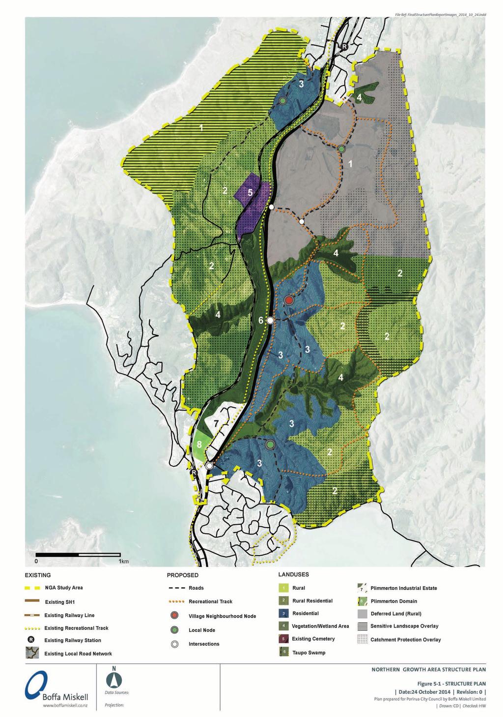
89
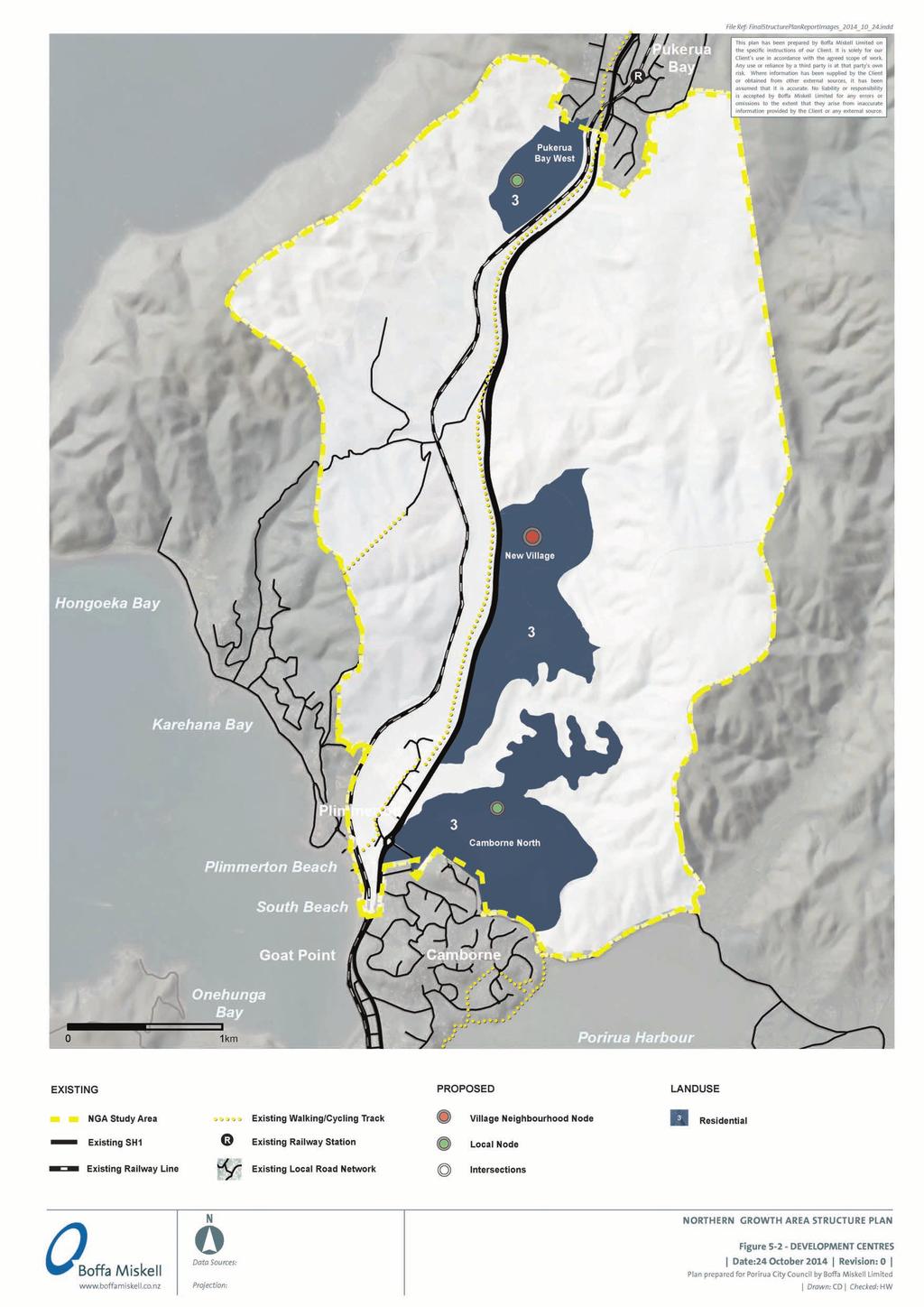
90

91

92

93

94


95 Figure Staging Plan R Stag age age Stag Stage Pha Ph age ag ase as a e Sub Su b ec ectt Ru Rura rall one P Pla lan n Ch Chan ange ge Stage Sta St Stag tage tag age age ag ge NB : All stages are to be read as exclusive of undevelopable land (e.g. Taupo Swamp 0 1km R Stage 1 2 2


 that can also")


96 Example : Katarawa Road, Reikorangi dw/ha 40 Ha Rural The rural area is generally open landscape where vegetation predominates over buildings. The area is characterised by a variety of vegetation and patterns, including pastoral, plantations and indigenous vegetation. Buildings are generally distributed sparsely throughout the area. Rural -Residential Rural-residential can meet the demand for rural lifestyle blocks while maintaining the open rural character of the land that is a valued quality of the area. Single detached houses can be clustered together with a common vegetation belt (preferably native planting) that can also function as a public access easement. The lots have a semi rural character with dense planting and views to the larger rural surrounds, while utilising the benefits of proximity to the City. Example : Murphys Road, Pauatahanui 0.35 dw/ha 2-5 Ha 6 dw/ha m² Low Density Residential Example : Mount Marua, Upper Hutt Large single detached dwellings in a garden setting. Houses suited to traditional family structure. Open space large enough to accommodate family leisure activities and a large garden. Garden may have some productive value such as fruit trees or vegetable patch. Large garages can be accommodated on site. Example : Aotea Development, Porirua 10 dw/ha m² Standard Residential Standard dwellings suited to a traditional family structure. Open space large enough to accommodate family leisure activities and a garden. Garages for one or two cars can be accommodated on site. Car is main form of transport to retail and community amenities. Medium Density Residential Dwellings are joined together by a shared party wall in a terrace or semi detached form. A garage for one car may be part of the structure. Open space on site is limited to a small private courtyard or balcony or a communal garden. Located close to the town centre, these dwellings are within walking distance of retail and community facilities, such as train stations. House types have benefits of low maintenance and cheaper heating/service bills. Diversity of housing types and sizes allows for different household structures and incomes. Example : Regents Park, Newtown 40 dw/ha m² Examples : Stone Street Studios, Miramar & Plimmerton Industrial Estate N/A N/A Industrial Areas compromising of range of industrial activities including warehousing, manufacturing and commercial services which cater for the immediate area, the city and the wider region. Because of the industrial nature of the activities in such areas, lower levels of amenity may be acceptable and are likely to include on site facilities such as car parking and loading areas. Mixed use development combines commercial and residential functions. Located in the town/village centre, the mix of uses brings more vitality to the central streets both during and outside commercial hours. Residents in these areas have the convenience of good access to retail and community facilities and local businesses have increased patronage. Different housing types allow for a greater diversity of household structures and incomes. Example : Churton Park Village Centre N/A N/A Commercial DENSITY CONCEPTS DESCRIPTION DENSITY AVERAGE (gross dw/ha) LOT SIZE (m²)
Tāhuhu whakaruruhau ā-taone The sheltering ridge pole
 B2. Tāhuhu whakaruruhau ā-taone - Urban growth and form B2.1. Issues Tāhuhu whakaruruhau ā-taone The sheltering ridge pole Auckland s growing population increases demand for housing, employment, business,
Plan Modification to Chapter B2 of the Auckland Unitary Plan(AUP) Operative in part (15 November 2016)
 Operative in part (15 November 2016)") UNITARY PLAN UPDATE REQUEST MEMORANDUM TO FROM Phill Reid Linley Wilkinson DATE 25 September 2018 SUBJECT Plan Modification to Chapter B2 of the Auckland Unitary Plan(AUP) Operative in part (15 November
UNITARY PLAN UPDATE REQUEST MEMORANDUM TO FROM Phill Reid Linley Wilkinson DATE 25 September 2018 SUBJECT Plan Modification to Chapter B2 of the Auckland Unitary Plan(AUP) Operative in part (15 November
Appendix 1 Structure plan guidelines
 Appendix 1 Structure plan guidelines This appendix forms part of the regional policy statement [rps]. 1.1. Introduction Structure plans are an important method for establishing the pattern of land use
RURAL ZONE - POLICY. Rural Zone Policy. Issue: Rural Environment. Ruapehu District Plan Page 1 of 8
 Rural Zone Policy RU2 RURAL ZONE - POLICY RU2.1 Introduction The natural resources of the rural environment in the Ruapehu District provide the basis for the existing and potential character, intensity
2A District-wide Policies
 2A Introduction This Chapter contains policies which are relevant to subdivision, use and development activities occurring across all zones and areas of the District. The policies in this Chapter implement
I615. Westgate Precinct
 I615. Westgate Precinct I615.1. Precinct Description The Westgate Precinct is located approximately 18km west of the Auckland city centre. There are seven Sub-precincts in the Westgate Precinct: Sub-precinct
HOROWHENUA DEVELOPMENT PLAN June create a safe crossing for children moving to and from the school and other areas. 7.8 Ohau
 7.8 Ohau create a safe crossing for children moving to and from the school and other areas. Ohau has a traditional village form with a collective of school, church and reserve at the main road intersection.
SECTION 2.4 URBAN DEVELOPMENT AND STRATEGIC URBAN DIRECTIONS
 SECTION 2.4 URBAN DEVELOPMENT AND STRATEGIC URBAN DIRECTIONS 2.4.1 INTRODUCTION In 1993/94 the Hastings District Council completed the Hastings Urban Development Strategy. The purpose of this study was:
Appendix A. Planning Processes. Introduction
 1 Planning Processes Introduction This appendix outlines a number of planning processes which are used in the Auckland Region to support the effective management of development in the region s rural and
4 RESIDENTIAL ZONE. 4.1 Background
 4 RESIDENTIAL ZONE 4.1 Background The residential areas within the City are characterised by mainly lowrise dwellings sited on individual allotments. Past architectural styles, settlement patterns and
H7 Open Space zones. (a) provide for the needs of the wider community as well as the needs of the community in which they are located;
 provide for the needs of the wider community as well as the needs of the community in which they are located;") H7. Open Space zones H7.1. Background The majority of land zoned as open space is vested in the Council or is owned by the Crown. However some areas zoned open space are privately owned. While the open
H7. Open Space zones H7.1. Background The majority of land zoned as open space is vested in the Council or is owned by the Crown. However some areas zoned open space are privately owned. While the open
Northern Territory Compact Urban Growth Policy
 Northern Territory Compact Urban Growth Policy A Reference Policy Document to clause 2.7 (Reference to Policy) of the NT Planning Scheme May 2015 Table of Contents 1 Policy Setting... 3 1.1 Context for
Newcourt Masterplan. November Exeter Local Development Framework
 Newcourt Masterplan November 2010 Exeter Local Development Framework Background The Exeter Core Strategy Proposed Submission sets out the vision, objectives and strategy for the development of Exeter up
12 Subdivision, Services and Infrastructure
 12 Subdivision, Services and Infrastructure Section 12A 12A Purpose of Subdivision Provisions... 1 12A.1 General Subdivision Objectives and Policies... 2 12A.2 Activity Status Rules... 4 12A.3 General
GREENBANK DEVELOPMENT MASTERPLAN
 DEVELOPMENT MASTERPLAN POTENTIAL TRAIN STATION COMMUNITY CENTRE Greenbank will be a connected masterplanned community providing easy access to local and surrounding amenity. Affordable quality homes, green
MAYFIELD WEST SECONDARY PLAN PHASE 2
 MAYFIELD WEST SECONDARY PLAN PHASE 2 Public Open House #3 February 25, 2010 Draft Preferred Land Use Scenario TOWN OF CALEDON PLANNING & DEVELOPMENT DEPARTMENT Open House Agenda TOWN OF CALEDON 1. Welcome
Chapter 3: Natural Environment. Proposed Waikato District Plan Stage 1. (Notified version)
") Chapter 3: Natural Environment Proposed Waikato District Plan Stage 1 Page 2 of 7 Contents Chapter 3: Natural Environment... 3 3.1 Indigenous Vegetation and Habitats... 3 3.1.1 Objective Biodiversity and
Chapter 3: Natural Environment Proposed Waikato District Plan Stage 1 Page 2 of 7 Contents Chapter 3: Natural Environment... 3 3.1 Indigenous Vegetation and Habitats... 3 3.1.1 Objective Biodiversity and
Land Use Amendment in Southwood (Ward 11) at and Elbow Drive SW, LOC
 at and Elbow Drive SW, LOC") 2018 November 15 Page 1 of 10 EXECUTIVE SUMMARY This land use amendment application was submitted by Rick Balbi Architect on 2017 August 31 on behalf of Sable Developments Ltd, and with authorization from
2018 November 15 Page 1 of 10 EXECUTIVE SUMMARY This land use amendment application was submitted by Rick Balbi Architect on 2017 August 31 on behalf of Sable Developments Ltd, and with authorization from
Section 6A 6A Purpose of the Natural Features and Landscapes Provisions
 Section 6A 6A Purpose of the Natural Features and Landscapes Provisions This Chapter addresses the protection and management of natural features and landscapes within the City. The City has a number of
3. Highway Landscaping Assessment
 Guidelines for Highway Landscaping 3-1 3. Highway Landscaping Assessment 3.1 Introduction This section outlines the steps necessary to assess the highway landscaping component of a state highway construction
Understanding Wellington City s DISTRICT PLAN
 Understanding Wellington City s DISTRICT PLAN Wellington City Council 1 UNDERTANDING WELLINGTON CITY S DISTRICT PLAN CONTENTS 1. Introduction...3 1.1. Overview of this Guide...3 1.2. What is the District
QUEENSTOWN LAKES DISTRICT COUNCIL SUBDIVISION DESIGN GUIDELINES
 Attachment C: Draft QLDC Subdivision Design Guidelines QUEENSTOWN LAKES DISTRICT COUNCIL DESIGN GUIDELINES A DESIGN GUIDE FOR AND DEVELOPMENT IN THE URBAN ZONES QUEENSTOWN OFFICE 10 Gorge Road Queenstown
B4. Te tiaki taonga tuku iho - Natural heritage
 B4. Te tiaki taonga tuku iho - Natural heritage Tuia I runga, tuia i raro, tuia ki te waonui a Tiriwa Bind the life forces of heaven and earth to the great realm of Tiriwa B4.1. Issues Auckland s distinctive
Section 12C Subdivision in the Rural Residential Zone
 Section 12C 12C Subdivision in the Rural Residential Zone The Rural Residential Zone provides part of the range of residential opportunities within the City. Land zoned rural residential is considered
WHITELEY TOWN COUNCIL NORTH WHITELEY DEVELOPMENT SEPTEMBER 2014
 WHITELEY TOWN COUNCIL NORTH WHITELEY DEVELOPMENT SEPTEMBER 2014 Dear Resident This Special Edition of the Whiteley Voice which has been prepared in conjunction with the North Whiteley Consortium is to
1. Assessment of Environmental Effects
 1. Assessment of Environmental Effects Table of Contents 1. Introduction and Overview 1 2. Statutory Assessment 3 3. Site Description 5 4. Proposal Description 7 5. Assessment of Effects on the Environment
TIDAPA Structure Plan
 TIDAPA Structure Plan Prepared by Tract Consultants 28 MARCH 2017 0217-0074 Table of Contents 01 STRATEGIC CONTEXT Executive Summary Regional Context Page 3 Page 4 02 LOCAL CONTEXT Aerial Photograph Local
Public Consultation. Land at Monks Farm, North Grove. Welcome
 Welcome Welcome to our public exhibition for development on Land at Monks Farm, orth Grove. Gallagher Estates and Gleeson Strategic Land are preparing an outline planning application for new homes, open
Town of Cobourg Heritage Master Plan. Statutory Public Meeting
 Town of Cobourg Heritage Master Plan Statutory Public Meeting April 25 th 2016 Presentation Overview 1. Introduction 2. Project background and schedule overview 3. Review of strategic direction content
SECTION E. Realizing the Plan
 SECTION E Realizing the Plan 60 DESIGN REGINA - OFFICIAL COMMUNITY PLAN SECTION E Realizing the Plan Design Regina has been an ambitious plan-making exercise, with a high level of community, stakeholder,
STATEMENT OF OBJECTION TO THE PROPOSED DEVELOPMENT OF LAND AT CHURCH CLIFF DRIVE FILEY
 STATEMENT OF OBJECTION TO THE PROPOSED DEVELOPMENT OF LAND AT CHURCH CLIFF DRIVE FILEY You will be aware that Scarborough borough council have adopted a new local plan that includes land at Church Cliff
AOTEA SUPERMARKET ZONE. Zone Introduction
 C18 AOTEA SUPERMARKET ZONE Zone Introduction C18.1 Objective This zone identifies a specific area in Aotea for a stand alone supermarket. The zone is site specific and has a range of objectives, policies
ROCHFORD LOCAL DEVELOPMENT FRAMEWORK: Sustainability Appraisal/ Strategic Environmental Assessment. Rochford Core Strategy Preferred Options Document
 ROCHFORD LOCAL DEVELOPMENT FRAMEWORK: Sustainability Appraisal/ Strategic Environmental Assessment Non Technical Summary Rochford Core Strategy Preferred Options Document October 2008 SUSTAINABILITY APPRAISAL
PART 5 - NATURAL AND PHYSICAL ENVIRONMENT
 CONTENTS...PAGE 5.1 INTRODUCTION...3 5.2 NATURAL RESOURCES...4 5.3 PHYSICAL RESOURCES...4 5.4 COASTAL ENVIRONMENT...4 5.5 HERITAGE FEATURES...4 5.6 HAZARDS...4 5.7 SUMMARY...4 ISTHMUS SECTION - OPERATIVE
I539. Smales 2 Precinct
 I539. Smales 2 Precinct I539.1. Precinct Description The Smales 2 Precinct applies to a 4.8 hectare block of land located on the southern side of Northcote Road and fronting Lake Pupuke, Takapuna. The
1.0 Purpose of a Secondary Plan for the Masonville Transit Village
 Report to Planning and Environment Committee To: Chair and Members Planning & Environment Committee From: John M. Fleming Managing Director, Planning and City Planner Subject: Masonville Transit Village
Section 3b: Objectives and Policies Rural Environment Updated 19 November 2010
 Page 1 of Section 3b 3b RURAL ENVIRONMENT 3b.1 Introduction The Rural Environment comprises all the land outside of the Residential, Town Centre and Industrial Environments. Most land within the District
DRAFT FOR YOUR FEEDBACK DRAFT LOGAN RESERVE PLAN
 DRAFT FOR YOUR FEEDBACK CONTENTS INTRODUCTION... BACKGROUND... State Government... Council... PLANNING LEGISLATION AND RULES... CONSULTATION PROCESS...... ENVIRONMENT AND CONSERVATION... HOUSING... Proposed
H1. Residential Large Lot Zone
 H1. Residential Large Lot Zone H1.1. Zone description The Residential Large Lot Zone provides for large lot residential development on the periphery of urban areas. Large lot development is managed to
9 CITY OF VAUGHAN OFFICIAL PLAN AMENDMENT NO BOCA EAST INVESTMENTS LIMITED
 9 CITY OF VAUGHAN OFFICIAL PLAN AMENDMENT NO. 631 - BOCA EAST INVESTMENTS LIMITED The Planning and Economic Development Committee recommends the adoption of the recommendations contained in the following
FORMER CANADIAN FORCES BASE (CFB) ROCKCLIFFE SECONDARY PLAN. Official Plan Amendment XX to the Official Plan for the City of Ottawa
 ROCKCLIFFE SECONDARY PLAN. Official Plan Amendment XX to the Official Plan for the City of Ottawa") FORMER CANADIAN FORCES BASE (CFB) ROCKCLIFFE SECONDARY PLAN Official Plan Amendment XX to the Official Plan for the City of Ottawa 1 INDEX THE STATEMENT OF COMPONENTS PART A THE PREAMBLE PAGE Purpose...
FORMER CANADIAN FORCES BASE (CFB) ROCKCLIFFE SECONDARY PLAN Official Plan Amendment XX to the Official Plan for the City of Ottawa 1 INDEX THE STATEMENT OF COMPONENTS PART A THE PREAMBLE PAGE Purpose...
Sustainability Statement. Whitby Business Park Area Action Plan
 Sustainability Statement Whitby Business Park Area Action Plan November 2014 Contents Page 1. Introduction 1 2. Scoping 3 3. Sustainability Appraisal of Options 6 4. Assessment of Draft Area Action Plan
SECTION ONE North East Industrial Zone Design Guide Palmerston North City Council June 2004
 SECTION ONE North East Industrial Zone Design Guide Palmerston North City Council June 2004 young heart easy living 1 Preface Industrial areas are a very important component of the economic well-being
Site Option 3: Te Matai
 Site Option 3: Te Matai Location Napier Drain looking south east Description The Te Matai growth option is located between the existing residential boundary (Ruamahanga Crescent) Napier Road (State Highway
8.0 Design and Form of Development 43/
 42/ 8.0 Design and Form of Development 43/ Rothwells Farm, Golborne/ Development Statement Figure 7. Site Constraints Key 44/ Site Boundary 360 Bus Route/Stops Existing Trees Underground Water Pipe Sensitive
The West Vaughan Employment Area Secondary Plan Policies
 Part 2: The West Vaughan Employment Area Secondary Plan Policies 2.1 General Policies It is the policy of Council: 2.1.1. That the West Vaughan Employment Area (the WVEA), identified on Schedule 1, will
CONSULTING SERVICES FOR THE WHITEBELT VISIONING EXERCISE ADDENDUM TO THE GTA WEST LAND USE STUDY WORK PROGRAM
 CONSULTING SERVICES FOR THE WHITEBELT VISIONING EXERCISE ADDENDUM TO THE GTA WEST LAND USE STUDY 1. Introduction WORK PROGRAM The Town of Caledon is a large, local municipality located in the Greater Toronto
Site Assessment Technical Document Appendix A: Glossary
 Central Bedfordshire Council www.centralbedfordshire.gov.uk Site Assessment Technical Document Appendix A: Glossary July 2017 1.1.11-1 - ii Appendix A: Glossary Term Agricultural Land Classification AONB
PUBLIC NOTICE UNDER CLAUSE 5 OF SCHEDULE 1 OF THE RESOURCE MANAGEMENT ACT 1991 PLAN CHANGE 12 TO THE OPERATIVE CITY OF NAPIER DISTRICT PLAN
 PUBLIC NOTICE UNDER CLAUSE 5 OF SCHEDULE 1 OF THE RESOURCE MANAGEMENT ACT 1991 PLAN CHANGE 12 TO THE OPERATIVE CITY OF NAPIER DISTRICT PLAN Public notice is given in accordance with Clause 5 of Schedule
CA.1 Coastal Area. Index. CA.1.1 Description and Expectations
 Index.1.2.3.4 CA.2 CA.2.1 CA.2.2 CA.2.3 CA.3 CA.3.1 CA.3.2 CA.3.1 CA.4 CA.4.1 CA.4.2 CA.4.3 CA.4.4 CA.5 CA.5.1 CA.5.2 Description and Expectations Objectives Policies Guidance Note Landuse Eligibility
Welcome. Walk Around. Talk to Us. Write Down Your Comments
 Welcome This is an information meeting introducing the applications for proposed redevelopment of the Yorkdale Shopping Centre site at 3401 Dufferin Street and 1 Yorkdale Road over the next 20+ years,
WELLINGTON CITY DISTRICT PLAN
 Section 32 Report WELLINGTON CITY DISTRICT PLAN PROPOSED DISTRICT PLAN CHANGE 54 REZONING 178 AND 180 OWHIRO BAY PARADE 1 Introduction Before a Proposed District Plan change is publicly notified the Council
The Proposed Auckland Unitary Plan (notified 30 September 2013)
") 3 Business zones Introduction There are 10 business zones in the Unitary Plan: City Centre Metropolitan Centre Town Centre Local Centre Neighbourhood Centre Mixed Use General Business Business Park Light
3 Business zones Introduction There are 10 business zones in the Unitary Plan: City Centre Metropolitan Centre Town Centre Local Centre Neighbourhood Centre Mixed Use General Business Business Park Light
CITY VIEW OBJECTIVES
 SECTION 2: CITY VIEW OBJECTIVES CONTENTS 2.1 Introduction 1 2.2 Strategic Direction 1 2.3 The City View Resource Management Issues for the City 1 2.4 The Goal 3 2.5 The City View Objectives 3 Palmerston
CONTENTS 8.0 LAND USE 8.1 GENERAL LAND USE 8.2 RESIDENTIAL 8.3 MIXED USE 8.4 COMMERCIAL 8.5 EMPLOYMENT LANDS
 8-2 Land Use 8.0 LAND USE CONTENTS 8.1 GENERAL LAND USE 8.1.1 Uses provided for in all Land Use Designations 8.1.2 Uses prohibited in Hazardous Lands, Hazardous Sites and Special Policy Areas 8.1.3 Uses
SH1 link to Matakana Road
 Future transport network for Warkworth Warkworth is expected to grow to a substantial satellite town of more than 20,000 people over the next few decades. To meet this anticipated growth, around 1,000
WELCOME GYPSY LANE. Wider Site Location plan. Proposals for the development of LAND OFF FOXLYDIATE LANE WEBHEATH. Proposals for the development of
 WELCOME The developers are preparing an outline planning application for a residential led development and need the community s views in order to develop the proposals further WHAT IS PROPOSED? A high
Complete Neighbourhood Guidelines Review Tool
 Complete Neighbourhood Guidelines Review Tool Prepared By: City of Regina Planning Department October 2014 Page 1 of 14 Community Development Review Checklist for Secondary Plans and Concept Plans The
Ipswich Issues and Options for the Ipswich Local Plan Review, August 2017, Public Consultation
 Ipswich Issues and Options for the Ipswich Local Plan Review, August 2017, Public Consultation Having reviewed the issues and options documents, the Society has made the following response: Part 1 Strategic
Planning Proposal Toronto Road, Booragul. Amendment to Lake Macquarie Local Environmental Plan (LMLEP) 2014
 2014") Planning Proposal Toronto Road, Booragul Amendment to Lake Macquarie Local Environmental Plan (LMLEP) 2014 Local Government Area: Name of Draft LEP: Subject Land: Land Owner: Applicant: Folder Number:
Planning Proposal Toronto Road, Booragul Amendment to Lake Macquarie Local Environmental Plan (LMLEP) 2014 Local Government Area: Name of Draft LEP: Subject Land: Land Owner: Applicant: Folder Number:
NEW REGIONAL OFFICIAL PLAN HIGH LEVEL PROCESS & FRAMEWORK
 NEW REGIONAL OFFICIAL PLAN HIGH LEVEL PROCESS & FRAMEWORK Why A New Official Plan Originally the role of Regionally Planning and content of Regional Official Plan (1970s) primarily focused on protecting
Appendix 18F: Tauriko Business Estate Services Strategy Statement and Sequencing Schedule
 Appendix 18F: Tauriko Business Estate Services Strategy Statement and Sequencing Schedule This statement describes key proposals for the development of infrastructure at Tauriko Business Estate. Appendix
GATEWAY AREA STRUCTURE PLAN
 CHESTERMERE GATEWAY AREA STRUCTURE PLAN COMMUNITY OPEN HOUSE SEPTEMBER 22 nd, 2015 PLAN AREA ± 512 hectares (± 1,265 acres) GATEWAY LOCATION UNDEVELOPED LANDS PRESENT AGRICULTURAL USE REGIONAL LAND USE
WELCOME. Land North of STEVENAGE. We would like to thank you for attending our public exhibition today.
 WELCOME We would like to thank you for attending our public exhibition today. The purpose of this event is to share our proposals and hear your thoughts on our ideas. Members of the project team are on
Rhode Island Shoreline Change Special Area Management Plan
 Rhode Island Shoreline Change Special Area Management Plan Draft Document Outline REVISED 10/12/2017 VOLUME 1 Executive Summary & How to Use this Document (Draft by Dec 2017) 1. Introduction (Revised draft
SECTION 7A: WHAKARONGO RESIDENTIAL AREA
 SECTION 7A: WHAKARONGO RESIDENTIAL AREA CONTENTS 7A.1 Introduction 1 7A.2 Resource Management Issues 1 7A.3 Objectives and Policies 1 7A.4 Methods 4 7A.5 Residential Zone 4 7A.5.1 Rules: Controlled Activities
LAND USE AMENDMENT CORNERSTONE (WARD 3) 60 STREET NE AND COUNTRY HILLS BOULEVARD NE MAP 26NE BYLAW 22D2017
 60 STREET NE AND COUNTRY HILLS BOULEVARD NE MAP 26NE BYLAW 22D2017") Page 1 of 14 EXECUTIVE SUMMARY This Land Use Amendment application covers an area of 43.76 hectares ± (108.14 acres ±) located in northeast Calgary, bound by Country Hills Boulevard NE to the south and
Page 1 of 14 EXECUTIVE SUMMARY This Land Use Amendment application covers an area of 43.76 hectares ± (108.14 acres ±) located in northeast Calgary, bound by Country Hills Boulevard NE to the south and
Planning Proposal Concurrent DA/LEP Amendment for Belmont North Pharmacy Amendment No. 24 to Lake Macquarie Local Environmental Plan (LMLEP) 2014
 2014") Planning Proposal Concurrent DA/LEP Amendment for Belmont North Pharmacy Amendment No. 24 to Lake Macquarie Local Environmental Plan (LMLEP) 2014 Local Government Area: Name of Draft LEP: Subject Land:
Planning Proposal Concurrent DA/LEP Amendment for Belmont North Pharmacy Amendment No. 24 to Lake Macquarie Local Environmental Plan (LMLEP) 2014 Local Government Area: Name of Draft LEP: Subject Land:
I611. Swanson North Precinct
 I611. Swanson North Precinct I611.1. Precinct Description Swanson North is located in the north eastern foothills of the Waitakere Ranges. It is outside the Waitakere Ranges Heritage Area Act and the Waitakere
SH1 - Causeway, Auckland, 2014 (Source: NZ Transport Agency)
") SH1 - Causeway, Auckland, 2014 (Source: NZ Transport Agency) Coastal effects assessment guide Environmental and social responsibility policy State highway environmental plan Transport Agency statement
SH1 - Causeway, Auckland, 2014 (Source: NZ Transport Agency) Coastal effects assessment guide Environmental and social responsibility policy State highway environmental plan Transport Agency statement
INCREMENTAL CHANGE AREA REVIEW March 2015 Page 1
 INCREMENTAL CHANGE AREA REVIEW March 2015 Page 1 Table of Contents Introduction... 3 Background to Review... 3 Comparison of the Schedules to the General Residential Zone... 7 Methodology... 7 Policy Context...
HAZARD MITIGATION GOALS AND OBJECTIVES
 SEWRPC Community Assistance Planning Report No. 282, 2nd Edition CITY OF MILWAUKEE ALL HAZARDS MITIGATION PLAN UPDATE Chapter IV HAZARD MITIGATION GOALS AND OBJECTIVES [NOTE: Throughout this plan update
BETTER URBAN PLANNING
 BETTER URBAN PLANNING SUBMISSION TO THE PRODUCTIVITY COMMISSION 3 OCTOBER 2016 BACKGROUND TO IPENZ The Institution of Professional Engineers New Zealand (IPENZ) is the lead national professional body representing
13 FUTURE DEVELOPMENT AND STRUCTURE PLANS
 13 FUTURE DEVELOPMENT AND STRUCTURE PLANS Contents 13.1 Introduction 13.2 Resource Management Issues 13.3 Objectives 13.4 Policies 13.5 Strategy 13.6 Implementation 13.6.1 District Plan Regulatory Methods
6 Growth Management Challenges and Opportunities
 6 Growth Management Challenges and Opportunities The Town has established a goal of attaining a 50% participation rate with respect to employment opportunities versus residential population. The Town s
The Proposed Auckland Unitary Plan (notified 30 September 2013)
") 8 Special Purpose zones 8.1 Airport zone The Airport zone applies to the Kaipara Flats Airfield, North Shore Airfield, Auckland International Airport and Ardmore Airport. Auckland International Airport
8 Special Purpose zones 8.1 Airport zone The Airport zone applies to the Kaipara Flats Airfield, North Shore Airfield, Auckland International Airport and Ardmore Airport. Auckland International Airport
Official Plan Review
 Official Plan Review Summary Report - The Built Environment August 2014 Part 1: Introduction Planning for a healthy, prosperous and sustainable community is an important goal for our municipality. From
WELLINGTON CITY COUNCIL REPORT OF THE HEARING COMMITTEE SUBJECT: PROPOSED DISTRICT PLAN CHANGE 47:TAKAPU ISLAND REZONING
 Approved by Council - 10 October 2007 WELLINGTON CITY COUNCIL REPORT OF THE HEARING COMMITTEE SUBJECT: PROPOSED DISTRICT PLAN CHANGE 47:TAKAPU ISLAND REZONING COMMITTEE MEMBERS: CRS Foster (Chair) McKinnon
Settlement Boundaries Methodology North Northumberland Coast Neighbourhood Plan (August 2016)
") Introduction This background paper sets out a methodology for the definition of settlement boundaries in the North Northumberland Coast Neighbourhood Plan. The neighbourhood plan is planning positively
Introduction This background paper sets out a methodology for the definition of settlement boundaries in the North Northumberland Coast Neighbourhood Plan. The neighbourhood plan is planning positively
PART 3 - RESOURCE MANAGEMENT
 CONTENTS... PAGE 3.1 INTRODUCTION... 3 3.2 NATURAL AND PHYSICAL ENVIRONMENT... 3 3.3 URBAN SUSTAINABLE MANAGEMENT... 5 3.4 RESOURCE MANAGEMENT ISSUES... 5 3.5 RESOURCE MANAGEMENT OBJECTIVES AND POLICIES...
THAT the attached Terms of Reference for the Thornhill Centre Street Study be approved.
 COMMITTEE OF THE WHOLE AUGUST 18, 2003 THORNHILL CENTRE STREET STUDY PLANNING FILE: 15.92 Recommendation The Commissioner of Planning recommends: THAT the attached Terms of Reference for the Thornhill
Subdivision and Development
 Subdivision and Development 8.0 Introduction - Subdivision and Development The principle purpose of subdivision is to provide a framework for land ownership so that development and activities can take
HURON COMMUNITY PLAN
 CITY OF KITCHENER DEPARTMENT OF DEVELOPMENT AND TECHNICAL SERVICES PD 94/7 HURON COMMUNITY PLAN Recommended by Planning and Economic Development Committee: October 31, 1994 Adopted by Kitchener City Council:
2 Policy Context. 2.1 Planning policy Proposed Regional Policy Statement (2009) Wellington Regional Strategy (2007) Landscape
 Wellington Regional Strategy (2007) Landscape") 2 Policy Context 2.1 Planning policy The design of the route has been informed by a number of policy documents which are particularly relevant as they contain key drivers for change in the Project area.
2 Policy Context 2.1 Planning policy The design of the route has been informed by a number of policy documents which are particularly relevant as they contain key drivers for change in the Project area.
Cotswolds AONB Landscape Strategy and Guidelines. June 2016
 Cotswolds AONB Landscape Strategy and Guidelines June 2016 Cotswolds AONB Landscape Strategy and Guidelines Introduction The evolution of the landscape of the Cotswolds AONB is a result of the interaction
Neighbourhood Planning Local Green Spaces
 Neighbourhood Planning Local Green Spaces Introduction... 2 1. Why green space is important... 4 2. Neighbourhood plans and green space... 6 3. Evidence... 8 Statutory designations... 9 Green space audit...
I609. Penihana North Precinct
 I609. Penihana North Precinct I609.1. Precinct description The Penihana North Precinct is located south of the Swanson Railway Station, adjacent to the Rural Urban Boundary (RUB) and Waitakere Ranges Heritage
A. WHAT IS A GENERAL PLAN?
 I. Introduction A. WHAT IS A GENERAL PLAN? A general plan is the planning guideline for the future of a city. It contains goals and policies which regulate urban development, the protection of the natural
THREE PARKS ZONE Three Parks Special Zone The process of applying for resource consents in the zone.
 .25 Three Parks Special Zone The purpose of this zone is to provide for growth and to give effect to the Wanaka 2020 Community (2002) and the more recent Wanaka Structure (2007) and Wanaka Transport Strategy
Neighbourhood Planning Site Assessment Pro-forma and Guide Version 2
 Neighbourhood Planning Site Assessment Pro-forma and Guide Version 2 September 2014 Site HNP 006 Land East of Stanbridge Road and North of Lower Road 1. Background information Site location and use Site
What progress have we made so far? NEWSLETTER PROPOSED IONA RESIDENTIAL DEVELOPMENT UPDATE
 MAY 2017 NEWSLETTER PROPOSED IONA RESIDENTIAL DEVELOPMENT UPDATE The Iona Working Group has been set up to encourage discussions between the parties involved in the Environment Court Process. This newsletter
Guidelines for Planning Authorities and Part V of the Planning and Development Act 2000: December 2000
 Slide 1 Slide 2 Slide 3 Slide 4 As a planner in practice, whether within the Local Authority, private practice or An Bord Pleanala, due regard must be given to the guidance provided by the Department in
Rural (Urban Expansion) Environment
 Environment") RUEE.1 Rural (Urban Expansion) Environment Subsequent to the receipt of appeals, a 'marked up' version of the Proposed District Plan was prepared. The provisions of the Proposed Version of the Plan subject
RUEE.1 Rural (Urban Expansion) Environment Subsequent to the receipt of appeals, a 'marked up' version of the Proposed District Plan was prepared. The provisions of the Proposed Version of the Plan subject
DAREBIN PLANNING SCHEME AMENDMENT C137
 Who is the planning authority? Planning and Environment Act 1987 DAREBIN PLANNING SCHEME AMENDMENT C137 EXPLANATORY REPORT This amendment has been prepared by the Darebin City Council, who is the planning
LONGDEN VILLAGE DEVELOPMENT STATEMENT
 LONGDEN VILLAGE DEVELOPMENT STATEMENT 2017-2027 1 Longden Development Statement 2017-2027 15/01/18 1. Background 1.1 Longden Village Longden village is a very rural and traditional community first mentioned
1.0 PLANNING MARKHAM S FUTURE CONTENTS
 1-1 Planning Markham s Future 1.0 PLANNING MARKHAM S FUTURE CONTENTS 1.1 THE PURPOSE OF THE OFFICIAL PLAN 1.2 THE MARKHAM CONTEXT 1.3 THE REGULATORY CONTEXT 1.3.1 Province of Ontario 1.3.2 York Region
MAYFIELD WEST SECONDARY PLAN PHASE 2
 MAYFIELD WEST SECONDARY PLAN PHASE 2 Council Information Workshop February 16, 2010 Draft Preferred Land Use Plan TOWN OF CALEDON PLANNING & DEVELOPMENT DEPARTMENT Workshop Agenda TOWN OF CALEDON 1. Welcome
E15. Vegetation management and biodiversity
 E15. management and biodiversity E15.1. Background contributes to a range of ecosystem services such as erosion and sediment control, reducing stormwater flows, protecting or enhancing water quality, amenity
PART 02 HASTINGS POINT IN CONTEXT
 PART 02 HASTINGS POINT IN CONTEXT 2.1 Background 2.1.1 Demographic Information 2.1.2 Existing Locality Characteristics 2.2 The Planning Framework 2.2.1 The Far North Coast Regional Strategy 2006 2.2.2
Strategic Environmental Assessment Screening Report. Dublin Port Masterplan Review 2017
 Strategic Environmental Assessment Screening Report Dublin Port Masterplan Review 2017 Table of Contents 1 Introduction... 1 2 Purpose of the Masterplan... 2 3 Task 1.1 Pre-Screening Check... 5 4 Task