Water Works: Downtown Minneapolis Riverfront Destination
|
|
|
- Lynette Howard
- 5 years ago
- Views:
Transcription
1

2 Water Works: Downtown Minneapolis Riverfront Destination Previous conceptual design process for Water Works began in 2012 along with the Central Mississippi Riverfront Regional Park Master Plan Update 2015 Water Works concept


3 Water Works: A Visionary Reset Preliminary design explorations in 2012 Conceptual design & community engagement in 2013/2014 Part of Central Riverfront Regional Park master plan update Concept design approved by Park Board in September 2015

4 A Park Program for the Next Generation

5 Phasing Strategy Mezzanine Phase Construction: 2017 Opening: 2019 Riverside Phase Construction: 2021 Opening: 2023
6 What Has Happened in the Past 12 Months Design / cultural resource team selected (DF, HGA, 106 Group, MacDonald & Mack, others) Deep historic / archeological analysis conducted Park and pavilion program analysis completed Precedents analyzed Former Fuji Ya building documented and deconstruction plans prepared Interviews with community leaders and elders and interpretive planning Rainwater reuse strategy completed and $900,000 granted by MWMO to implement it $12.3m of $15m philanthropic goal achieved
7 What Has Been Learned Water Works is even more complex than already understood The structural remnants of Bassett and Columbia Mills are rich and engaging There are countless untold stories that could be expressed Water Works holds the opportunity to be A venue for storytelling and more importantly, A venue for people and peoples to tell their own stories As a result an evolved concept
8 What Will Happen Over the Next 12 Months Apr-June May 1&2 June 7 June 28 June July-Aug July-Mar 2017 December 2018 Community reengaged around evolved concept Public Open Houses MPRB Planning Committee considers evolved concept 6:30 public hearing MPRB full Board approval, 5:00 PM Historic agency permits for Fuji Ya selective demo and stabilization Work on former Fuji Ya building begins Schematic design and construction docs Food vendor RFI released Finish out fundraising campaign Archaeological excavation and park construction

9 Water Works Cultural Resources 106 Group


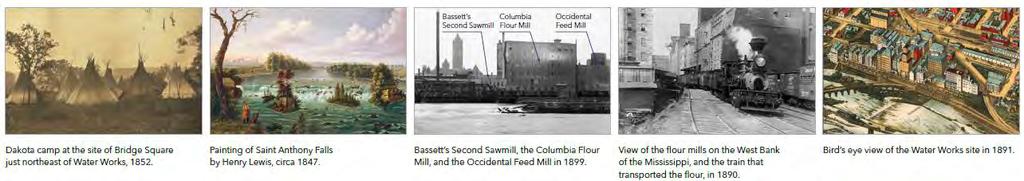
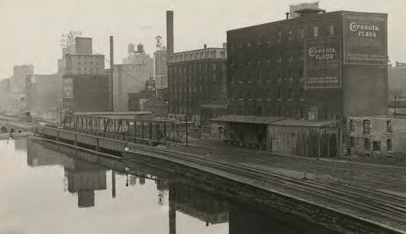
10 Historic Mill Structures Within the Mezzanine Phase of work include the foundations of the Bassett Mill, Columbia Mill, and Occidental Mill


11 Interpretive Planning Began in 2016 The cultural resources team is seeking to understand some of the lesser known history of marginalized communities around the site Team is currently conducting a second round of interviews with Native American elders and African American elders Read the Interpretive Planning Research and Implications

12 Cultural Resources


13 OPPORTUNITIES


14 OPPORTUNITIES
, Gold Medal Park (3.")
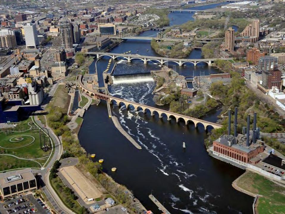
15 SITE CONTEXT Water Works is on the west bank of downtown Minneapolis just north of where the Stone Arch Bridge reaches the west bank and south of where the Third Avenue Bridge reaches the west bank of the river. This area referred to as the Mill District includes the Mill City Museum (1.5 blocks to the south), Gold Medal Park (3.5 blocks to the south), The Commons and US Bank Stadium further west, Cancer Survivors Park and the Gateway District along Hennepin Avenue to the north, and Nicollet Island and Hennepin Island and Water Power Park in the river to the east. West River Parkway extends through this entire area along the river.
, Riverwest (residential tower), Engine House (offices) and Mill Place (offices).")
16 SITE PLAN Project is bound by First Street on west, Third Avenue Bridge on north, West River Parkway on east, and Fifth Avenue on south. Adjacent buildings include the Crown Roller Mill (city offices), Riverwest (residential tower), Engine House (offices) and Mill Place (offices). West River Parkway divides the current project site from the river. The second phase of the project (Riverside Phase) will address the shoreline and area to the south and east of the parkway. At the south end of the project, the proposed pavilion forms a retaining wall between First Street and the lower park level. A plaza in front of the pavilion provides outdoor seating and flexible park space. The one story pavilion also has a usable rooftop deck that is generally at the elevation of First Street. North of the pavilion are the city steps that terrace from First Street down to the lower park level and can be used as informal social seating and gathering for performances. Adjacent to, and north of, the city steps, the hillside provides a natural area and children s place space overlooking the park below. In front of the city steps and hillside, a lawn area allows for flexible park uses.
17 SITE CIRCULATION West River Parkway and the adjacent bicycle and pedestrian pathway along the river are heavily traveled. At the southern end, the Stone Arch Bridge brings visitors to the park. The current bridge trail ends near a parking lot. A future connection will bring visitors directly to the existing river trail. The First Street and Fifth Avenue intersection is about 20 feet higher than West River Parkway. An accessible ramp at the southern corner of the project will bring pedestrians down to the lower park and parkway level where the main building entrance is. The northern end of the pavilion rooftop is accessible from the First Street sidewalk. Adjacent to the pavilion, the city steps also provide access from First Street to the lower level of the park. At the northern end of the site, the First Street and Third Avenue Bridge intersection is about 33 feet higher than West River Parkway. From the woonerf, pedestrians have accessible routes down to the lower park level (plaza, parkway, and building entrance), or up to the First Street and rooftop level. Bicyclists have a route from the woonerf to the parkway trails at the northern perimeter of the site.

18 CULTURAL RESOURCES Several historic structures exist on site and will be integrated into the plan. The small plaza at the south end of the site incorporates unidentified structural ruins. There are mill walls and mechanics underground, but the exact configuration is still unknown. Early archaeological digging will help the team design around the remnants. The pavilion will reuse the walls of the Bassett and Columbia Mills. The city steps will use the back wall of the Occidental feed mill and will work with the front wall if it exists. The historic railroad right-of-way extends straight off of the Stone Arch Bridge and swings west into the plaza and lawn area. An existing scale pit is directly between the historic rail path and the Columbia Mill. The historic rail right of way will be interpreted on site.

19 EXISTING CONDITIONS VIEW FROM 3 RD AVENUE BRIDGE
20 CONCEPT VIEW VIEW FROM 3 RD AVENUE BRIDGE Pavilion and city steps are at the far south end of the park. Along the east edge, First Street is generally level with the pavilion roof. West River Parkway forms the west edge of the project site; the narrow strip of land between the parkway and the river is included in the future second phase. Just east of West River Parkway, linear lawn space approximately 25 feet wide allows for small and large group use. The lawn is slightly above the parkway elevation at the northern half of the park. Accessible pathways from the woonerf provide access to the upper and lower levels of the park.

21 CONCEPT PLAN ENLARGED SOUTH AREA The southern area of the park is defined by the Crown Roller Mill, Riverwest, the new pavilion building, and West River Parkway which curves to form a triangular plaza south of the pavilion. An accessible route is provided through the triangular plaza from First Street to the lower level. The plaza in front of the pavilion opens directly onto the new parkway crossing that leads to the Stone Arch Bridge.

22 SECTION PARK PAVILION & PLAZA The pavilion acts as a retaining wall between the upper level on First Street and the lower level near West River Parkway. The building roof is slightly above First Street. Because the street slopes, the building roof elevation is even with the sidewalk on the north end, allowing for rooftop access. The building floor is even with the lower park level and the plaza is generally level with West River Parkway. Beyond the parkway, land slopes down to the river.

23 PARK PAVILION CONCEPT VIEW

24 PARK PAVILION CONCEPT VIEW The pavilion entrance is centrally located between historic mill walls and an outdoor plaza will be generally at the same level as the parkway and building entrance. West River Parkway will have new crossings and the team will examine strategies for crossings that prioritize pedestrians and methods for calming traffic.

25 PAVILION EXPLODED AXONOMETRIC
26 PAVILION ROOF PLAN 1ST STREET SIDEWALK RAMP UP VERTICAL CIRCULATION / LOBBY GREEN ROOF ROOFTOP PLAZA PARKWAY PLAZA BELOW
27 PAVILION PARKWAY FLOOR PLAN STORAGE / UTILITIES VERTICAL CIRCULATION UTILITIES KITCHEN TRASH RESTROOMS MEETING ROOM LOBBY / INFO DESK CAFE LOADING ENTRY VESTIBULE PARKWAY PLAZA

28 CAFE INTERIOR CONCEPT The public seating area inside the building cafe is a long, linear space with glass walls and likely will include doors leading directly to the outdoor seating plaza. The glass wall is just inside of the historic mill foundation wall that remains.

29 CONCEPT VIEW GREENROOF AND PLAZA
 of the pavilion is the edge of the plaza in front of the building.")
30 CONCEPT VIEW GREENROOF AND PLAZA On the roof a walkway around the edge and railing provide an overlook area. A small green roof area could be used for lawn games and flexible picnic area. To the right (east) of the pavilion is the edge of the plaza in front of the building. Further north is the mezzanine lawn with a walkway along the east side and the city steps and hillside shaping the space on the west.

31 ENLARGED PLAN NORTH SIDE The north end of the park is defined by the one story Engine House and the larger Riverwest and Mill Place buildings to the west. West River Parkway generally parallels First Street and forms a rectangular park area. An accessible route is provided from the upper First Street level to the lower woonerf level and then from the woonerf down to the parkway level. The city steps and hillside transition from the upper First Street level to the lower lawn level. A play area is incorporated into the hillside and lawn area. A future pedestrian connection will be provided from the Third Avenue/First Street intersection down to the park level. The woonerf is the primary bicycle route through the site down to the Stone Arch Bridge and riverfront trails. The bicycle route will eventually continue north under the Third Avenue bridge on the west side of West River Parkway and to the river trails on the east side.
32 CONCEPT VIEW EVENT LAWN AND CITY STEPS

33 CONCEPT VIEW EVENT LAWN AND CITY STEPS Mezzanine lawn is about 25 feet wide and is open for flexible use. To the right of the lawn in this view, a walkway provides a connection from the north end of the project to the plaza at the south end. The lawn stays fairly level and the walkway slopes down toward the plaza. Seating facing the river is provided where lawn and walkway meet. To the left of the lawn the city steps provide seating overlooking the lawn and river. The steps provide a transition for people to move between First Street at the upper level and the lawn and main park area below.

34 SECTION CITY STEPS AND MEZZANINE LAWN The city steps provide seating terraces down from the First Street level to the lower mezzanine lawn, which is several feet above West River Parkway. First Street is approximately one story higher than the lawn and parkway at this area.

35 SECTION PLAY AND MEZZANINE LAWN The hillside transitions down from the First Street level to the lower mezzanine lawn. An accessible walkway runs from First Street down the hillside to the woonerf. Childrens play is incorporated into the hillside and northern end of the park.

36 CONCEPT VIEW PLAY AREA AND MEZZANINE PROMENADE

37 CONCEPT VIEW PLAY AREA AND MEZZANINE PROMENADE Winter scene shows that sledding may be possible on the lower part of the hillside. Lights, luminaries, ice sculptures and other winter attractions may be a part of winter programming on the lawn.

38 SECTION WOONERF PLAZA The woonerf enters the site under First Street and the existing bridge abutment wall may be an opportunity for public art, etc. From the woonerf, an accessible route leads north to First Street or south down to the mezzanine lawn, walkway, and West River Parkway. The site in this area spans approximately three stories with the Third Avenue and First Street intersection at the top, the woonerf in the middle, and West River Parkway below.

39 CONCEPT VIEW VIEW FROM 3 RD AVENUE BRIDGE

40 CONCEPT VIEW VIEW FROM 3 RD AVENUE BRIDGE Pavilion and city steps are at the far south end of the park. Along the east edge, First Street is generally level with the pavilion roof. West River Parkway forms the west edge of the project site; the narrow strip of land between the parkway and the river is included in the future second phase. Just east of West River Parkway, linear lawn space approximately 25 feet wide allows for small and large group use. The lawn is slightly above the parkway elevation at the northern half of the park. Accessible pathways from the woonerf provide access to the upper and lower levels of the park.

41 Your Experience at Water Works Creating Community Life After the Ribbon Cutting Activities, Amenities, and Experiences to: Ensure the design realizes its fullest potential Celebrate the wonderful cultural diversity of the site and our city in the park Enable the life of the park to evolve to meet the ever-changing needs and opportunities of our community Our Output Crafting list of priority experience, uses and activities for user groups Developing the activities and events plan for the site
42 Fostering a Continuum of Experiences Ensuring Public Enjoyment Across Times and Seasons Places to sit Games to play Food to eat Walking your dog Water to drink Exercising Walking Biking Nap in the grass Photo ops Markets Small performances Picnics Buskers Family gatherings Art making classes Cultural and historical classes Community meetings Walking tours Community festivals Installations Field trips Weddings Outdoor movies Northern Spark Large concerts, performances Stone Arch Bridge Festival Opera Fitness events

43 What We ve Heard Thus Far:

44 What We ve Heard Thus Far Access to water and natural habitat Winter activities Programs, activities and amenities that are relevant to the diversity of cultures and traditions of the site Spaces for all ages Food to buy and eat onsite Comfortable venues to people watch Enhance the walking, running, and biking experience Clean and safe public restrooms

45 Water Works: The User Experience What do you want to be able to do at this space? Activities Uses Events Rituals Routines
46 Water Works: The User Experience Imagine yourself visiting Water Works Park alone or with others in 5 years. What is the one thing you notice, feel, experience most?
47 Water Works: The User Experience How can food be central to the Water Works experience?
5. Father Hennepin Blufs Park and Hennepin Island Father Hennepin Bluffs Park Supporting Initiatives (see Figure 36): 7-22
: 7-22") 5. Father Hennepin Blufs Park and Hennepin Island As described in existing conditions portion of Chapter 2, Father Hennepin Blufs Park lies on the upland portion of the park and Hennepin Island spans the
5. Father Hennepin Blufs Park and Hennepin Island As described in existing conditions portion of Chapter 2, Father Hennepin Blufs Park lies on the upland portion of the park and Hennepin Island spans the
JACKsON STREET PIER CONCEPTUAL DESIGN PACKAGE SEPTEMBER 21, 2017
 JACKsON STREET PIER CONCEPTUAL DESIGN PACKAGE SEPTEMBER 21, 2017 JACKsON STREET PIER Process outline DESIGN PROCESS OVERVIEW: Sandusky s Jackson Street Pier Conceptual Design process included input from
03 HIGH PRIORITY SITES
 03 HIGH PRIORITY SITES HOWARD PARK Howard Park is one of South Bend s largest riverfront parks, hosting nearly acres. Howard Park has a very passive landscape with a recreation building, ice skating rink,
Waterfront Development Master Plan
 PORT of VANCOUVER USA Vancouver, WA Waterfront Development Master Plan DRAFT - FINAL CONCEPTUAL MASTER PLAN PROJECT TEAM NBBJ Heritage Research Associates JLA Kittelson Associates Leland Consulting Group
4 Park Planning and Design
 4 Park Planning and Design Park Constellations Elliot Gateway/Mills Loring North Loop Commons Twins Minneapolis Park & Recreation Board Downtown Service Area Master Plan 4-1 PROJECT APPROACH REFERENCE
TOWN COUNCIL / PLANNING COMMISSION
 Workshop #3 TOWN COUNCIL / PLANNING COMMISSION January 20, 2011 Consultant Team In Attendance Tonight BMS Design Group Nevada City and San Francisco Michael Smiley, AICP, ASLA Partner-in-Charge Nancy L.
11TH STREET BRIDGE PARK COMPETITION
 11TH STREET BRIDGE PARK COMPETITION DESIGN PRINCIPLES, VALUES AND FACILITIES DESCRIPTION The design principles and list of facilities for a future 11th Street Bridge Park have been gathered through over
BRADENTON RIVERWALK EXPANSION MASTER PLAN
 BRADENTON RIVERWALK EXPANSION MASTER PLAN INTRODUCTION & AGENDA Process Update Community Engagement Summary Center for Active Design (CfAD) Recommendations Context and Existing Conditions Master Plan Alternatives
Johnson Street Bridge Public Realm Update
 Johnson Street Bridge Public Realm Update August 20, 2015 Background Johnson Street Bridge Replacement Project impacts a diverse range of stakeholders In addition to a new bridge, the project also includes
PIQUA OHIO PLACEMAKING INITIATIVE
 PIQUA OHIO PLACEMAKING INITIATIVE A HANDBOOK to understanding the Placemaking Initiative for Piqua, Ohio June 15 2016 GAMBLE ASSOCIATES urban design BOOKER DESIGN COLLABORATIVE landscape architecture CITYVISIONS
Stadium District Masterplan
 Stadium District Masterplan Masterplan (noun): an evolving long-term planning document that establishes the framework and key elements of a site. It reflects a clear vision synthesizing developer goals
City of Farmington. Downtown Plan. Amendment to the 1998 Master Plan Adopted October 11, 2004
 City of Farmington Amendment to the 1998 Master Plan Adopted October 11, 2004 Introduction Planning Background 1 Scope and Components of the Plan Amendment 2 Concept Introduction 3 Plan Concepts 3 Conceptual
WARM SPRINGS PARK MASTER PLAN
 TABLE OF CONTENTS page 1.0 Introduction and Overview 1 2.0 Information Gathering 2 3.0 Conceptual Alternative Development 8 4.0 Master Plan Development 14 5.0 Construction Cost Estimates 19 LIST OF FIGURES
Reconnecting to a Forgotten River St. Cloud MN. Aaron Hanson Design Design Thesis LA 572, Thesis, Spring 2012
 Reconnecting to a Forgotten River St. Cloud MN Aaron Hanson Design Design Thesis LA 572, Thesis, Spring 2012 site context 2.5 Miles Sartell St. Cloud to Fargo 170 Miles (2 hrs 45 mins) Hwy 10 infrastructure
Public Workshop 2 December 11, 2014 OLIN
 Public Workshop 2 December 11, 2014 OLIN TRIPLE IMAGE PANORAMA A NEW VISION FOR THE RIVERFRONT PROMENADE Burlington s Riverfront has historically been a defining character of the City s identity. This
South th E ast Communit ity Centre (SECC)
") South East Community Centre (SECC) 1 New Park Design & Community Centre Update Thursday, February 8, 2018 Public Open House Thank you for attending this Open House! The town and the Consulting Team will
South East Community Centre (SECC) 1 New Park Design & Community Centre Update Thursday, February 8, 2018 Public Open House Thank you for attending this Open House! The town and the Consulting Team will
City of Poughkeepsie Waterfront Redevelopment Strategy. Poughkeepsie Waterfront Redevelopment Strategy
 City of Poughkeepsie Waterfront Redevelopment Strategy Poughkeepsie Waterfront Redevelopment Strategy City of Poughkeepsie Prime Assets: Major Waterfront Advantages: - Central City of the Hudson River
1.1 WATERFRONT SEATTLE
 1.1 WATERFRONT SEATTLE Over the past few years, the City of has been actively re-imagining the future of its Central Waterfront. The imminent replacement of the Elliott Bay Seawall and removal of the Alaskan
DOWNTOWN GEORGETOWN PLANNING STUDY
 DOWNTOWN GEORGETOWN PLANNING STUDY Community Workshop #3 Thursday, May 4, 08 The Planning Partnership OVERVIEW OF STUDY, PROCESS & MILESTONES We are here PURPOSE OF THE STUDY To develop a clear vision
Project purpose. advise. The purpose of the Beaumaris Lake Open Space Rehabilitation project is to: + Develop a Functional Program Concept
 Project purpose owns Road Beaumaris Road The purpose of the Beaumaris Lake Open Space Rehabilitation project is to: + Develop a Functional Program Concept + Guide Rehabilitation of Landscape and Community
Potential Green Infrastructure Strategies May 6, 2015 Workshop
 Potential Green Infrastructure Strategies May 6, 2015 Workshop Background The City of Cortland is developing the Tioughnioga Urban Headwaters Green Infrastructure Action Plan with funding from the National
South Bend Park. Visioning Plan
 South Bend Park Visioning Plan 2007 South Bend Park, Visioning Program, Executive Summary The South Bend Park Visioning Program began with the receipt of an application from the Friends of South Bend Park,
Public Meeting. October 25, 2016 Industry. Project Funded By: ADJACENT PRIVATE DEVELOPERS/OWNERS
 RIVER NORTH PROMENADE Public Meeting October 25, 2016 Industry Project Funded By: ADJACENT PRIVATE DEVELOPERS/OWNERS Agenda Update On Scope + Schedule Where We Left Off What We Heard What We ve Learned
The Vision. Photo provided by The Minervini Group. 46 Vision, Objectives & Strategies
 Vision, Objectives & Strategies The is the public framework and guide for future development of the Grand Traverse Commons. The establishes public polices for infrastructure, the preservation of natural
APPENDIX C Township 9 Consistency with Applicable Plans
 Township 9 Consistency with Applicable Plans 1985 American River Parkway Plan Policies Project Consistency Policy 4.14: The following activities and facilities, which are incompatible with the Parkway,
MISSISSIPPI GORGE REGIONAL PARK MASTER PLAN
 MISSISSIPPI GORGE REGIONAL PARK MASTER PLAN Minneapolis Park and Recreation Board CAC MEETING #1 APRIL 23, 2018 AGENDA Mississippi Gorge Regional Park Master Plan CAC #1 01 / Welcome and Calling Circle
Bethlehem Pike Streetscape Master Plan
 Bethlehem Pike Streetscape Master Plan Prepared for Springfield Township October 2008 By Michael Baker Jr., Inc. Carter Van Dyke Associates Table of Contents 1. Introduction 3 2. General Corridor Wide
Courthouse Square Planning & Urban Design Study. Courthouse Square Working Group #13 October 15, 2014
 Courthouse Square Planning & Urban Design Study Courthouse Square Working Group #13 October 15, 2014 1 Courthouse Square Process Working Group Community Courthouse Square Advisory Groups & Civic Associations
Bloor Street East Potential Ravine Portal Overlook and Access Passage to the Rosedale Valley and Don River Valley Ravine, Toronto, Canada
 TRANSFORMATIVE IDEA 2. GREAT STREETS Bloor Street Christie Pits Park Bloor St Spadina Ave Bathurst St Shaw St 1 Recognize the significant public realm improvements along Bloor Street and extend and enhance
Welcome. Community Consultation Meeting November 28, Review and discuss the Bathurst Quay Neighbourhood Plan Framework
 Welcome Community Consultation Meeting November 28, 2016 Why Are We Here Today? Review and discuss the Bathurst Quay Neighbourhood Plan Framework Review and discuss an Action Plan for Implementation Next
Community Engagement Committee Meeting #1 December 10, :30pm-8:30pm
 Community Engagement Committee Meeting #1 December 10, 2014 6:30pm-8:30pm Welcome and Introductions Dana Murdoch Minneapolis Park and Recreation Board Project Manager Ryan French Walker Art Center Director
Town Center (part of the Comprehensive Plan)
") Town Center (part of the Comprehensive Plan) Mercer Island Town Center Looking North (2014) In 1994, a year-long process culminated in a set of design guidelines and code requirements for the Town Center
Town Center (part of the Comprehensive Plan) Mercer Island Town Center Looking North (2014) In 1994, a year-long process culminated in a set of design guidelines and code requirements for the Town Center
PORT OF VANCOUVER WATERFRONT DEVELOPMENT. Concept Development Plan City Center Redevelopment Authority April 20, 2017
 PORT OF VANCOUVER WATERFRONT DEVELOPMENT Concept Development Plan City Center Redevelopment Authority April 20, 2017 Port History PORT ESTABLISHED 1912 TERMINAL 1 ACQUIRED 1925 GWM SIGNS LEASE 1935 HARBOR
DRAFT SECTION 4(F) EVALUATION STILLWATER MUNICIPAL BARGE FACILITY
 EVALUATION STILLWATER MUNICIPAL BARGE FACILITY") DRAFT SECTION 4(F) EVALUATION I. DESCRIPTION OF SECTION 4(F) RESOURCE The Section 4(f) resource discussed in this evaluation is known as the Stillwater Municipal Barge Facility property, known previously
DRAFT SECTION 4(F) EVALUATION I. DESCRIPTION OF SECTION 4(F) RESOURCE The Section 4(f) resource discussed in this evaluation is known as the Stillwater Municipal Barge Facility property, known previously
SOUTH UNIVERSITY Street Design Alternatives in Progress
 1 Alternatives in Progress 2016.01.20 Meeting Agenda 2 1. Progress & Schedule 2. Utilizing the Street Design Manual 3. Site Characteristics and Input Received 4. Street Geometry What can we accomplish
UNION STUDIO Greater Kennedy Plaza!
 April May 2013 UNION STUDIO Greater Kennedy Plaza! It s time: Providence s civic plaza and transit hub is re-imagined as a vibrant urban gathering place 1 Kennedy Plaza Reborn THE TEAM Client: The City
Appendix I ARLINGTON COUNTY SECTOR PLANS SUMMARY RECOMMENDATIONS RELATED TO PUBLIC SPACES
 Appendix I ARLINGTON COUNTY SECTOR PLANS SUMMARY RECOMMENDATIONS RELATED TO PUBLIC SPACES The County has developed Sector Plans for various planning areas within Arlington County s Metro corridors. Following
EcoVerde MADISON TO DOWNTOWN TO BEACH. Legend Highway Major Connection Major Street Local Street Proposed Access. Response to Tropicana Field RFP
 EcoVerde TO BEACH 275 16th Street North 16th Street South 13th Street North 13th Street South 11th Street North 11th Street South 1st Avenue North Central Avenue 1st Avenue South TO DOWNTOWN 2nd Avenue
Mendota Heights 2040 Comprehensive Plan Draft Vers
 4 Parks and Trails The City of Mendota Heights boasts a variety of recreational and open space opportunities. Few cities can claim access to regional trails, riverside and lakeside parks, scenic bluffs
ROUND ONE PROJECTS. Capital Grants 18 DELAWARE VALLEY REGIONAL PLANNING COMMISSION
 ROUND ONE PROJECTS DVRPC awarded the first round Take Me to the River grants in 2008 (see Figure 5 for project locations). The 13 projects selected were chosen based on their ability to reconnect citizens
City of Plattsburgh DRI: Downtown Streetscapes & Riverfront Access. Downtown Streetscape and Riverfront Access Design
 City of Plattsburgh DRI: Downtown Streetscapes & Riverfront Access Welcome Thank you for coming this evening. Agenda PART I - Project Context The Downtown Revitalization Program Our DRI Projects Other
Classroom Science Building
 Classroom Science Building Public Realm Presented by: Gary Branville, Joe Moore, Justin Rechtzigel, Tom Roth & Hailey Wall Proposal Objective: To create a node on the Grand Rounds Parkway Connect the public
Elliot Park 2. Neighborhood Master Plan. Historical Perspective
 Elliot Park 2 Neighborhood Master Plan Historical Perspective August 2002 Early History Development patterns and the growth of Minneapolis largely grew out of the city s historical response to its geography.
GOODY CLANCY WITH KITTELSON & ASSOCIATES RHODESIDE & HARWELL FARR ASSOCIATES W-ZHA
 1 1. Welcome 5 min. 2. Follow-up from 9/22 / Corridor of Light, ground floor uses 20 min. 3. Small on-site open spaces / Overview of types, identities 15 min. 4. Rosslyn Plaza Park / Rosslyn Plaza PDSP
New Westminster Downtown Parking Strategy Public Open House #1 September 13, 2012
 New Westminster Downtown Parking Strategy Public Open House #1 September 13, 2012 The City is preparing a strategy for parking in Downtown New Westminster. The study team and a group of key stakeholders
Preliminary Sketch Plan for Fort Hunter Park
 Preliminary Sketch Plan for Fort Hunter Park Public Presentation November 19, 2009 Dauphin County Parks and Recreation 100 Fort Hunter Road Harrisburg, PA 17110 (717) 599-5188 www.dauphinc.org THOMAS COMITTA
Las Colonias Park Master Plan
 2013 Las Colonias Park Master Plan City of Grand Junction June 2013 Introduction Las Colonias Park, a 101 acre parcel on the edge of the Colorado River south of downtown, was deeded to the City of Grand
Sub-committee on Harbour Plan Review of Harbour-front Enhancement Committee. Ninth Meeting
 Sub-committee on Harbour Plan Review of Harbour-front Enhancement Committee Ninth Meeting Date: 5 October 2005 Time: 3:30pm Venue: Conference Room 15/F, North Point Government Offices, 333 Java Road, North
Public responses to the question what do you want Muscatine to be, 20 years from now? (Responses were categorized as follows)
") Mississippi Drive Kickoff Event 9/1/2015 Blue Zones Kickoff Presentation Public responses to the question what do you want Muscatine to be, 20 years from now? (Responses were categorized as follows) Physical
Mississippi Drive Kickoff Event 9/1/2015 Blue Zones Kickoff Presentation Public responses to the question what do you want Muscatine to be, 20 years from now? (Responses were categorized as follows) Physical
ROCKTON DOWNTOWN STREETSCAPE MASTER PLAN. Plan Commission Presentation April 10, 2018 Teska Associates Christopher Burke Engineering
 ROCKTON DOWNTOWN STREETSCAPE MASTER PLAN Plan Commission Presentation April 10, 2018 Teska Associates Christopher Burke Engineering AGENDA 1. Project Scope & Schedule 2. Steering Committee & Community
Figure 3-1: Public Realm Plan
 3 Public Realm Figure 3-1: Public Realm Plan 3.1 Public Realm Concept The public realm concept for the Little Mountain site integrates a clear and accessible movement network with public spaces for social
Chinatown. Green Street Demonstration Project. land + water. community
 Chinatown Green Street Demonstration Project land + water community 2 Purpose. Dear Stakeholder, Thank you for your interest in making our neighborhood a greener, more sustainable, and attractive place
FACT SHEET: COMMUNITY INPUT S IMPACT ON THE DESIGN FOR THE OBAMA PRESIDENTIAL CENTER
 FOR IMMEDIATE RELEASE January 10, 2018 Contact: Kate Berner, kberner@skdknick.com FACT SHEET: COMMUNITY INPUT S IMPACT ON THE DESIGN FOR THE OBAMA PRESIDENTIAL CENTER Since announcing initial plans in
TURN TO THE RIVER CITY PLAZA LANDSCAPE DESIGN CONCEPT May 25, 2016
 Turn to the River is a multi-year project of Art Spaces - Wabash Valley Outdoor Sculpture Collection, Inc. to connect downtown Terre Haute with the Wabash River through public art and design. The four-square
ROBBINSDALE LRT STATION CDI DEVELOPMENT GUIDELINES
 August 2018 OVERVIEW The City of Robbinsdale has a prime-opportunity site in the middle of the 13 mile stretch of the Bottineau LRT corridor / Blue Line extension. Robbinsdale offers a prominent, vital,
ARISE: The Rock Renaissance Area Redevelopment & Implementation Strategy
 2014 Professional Awards 1 ARISE: The Rock Renaissance Area Redevelopment & Implementation Strategy Janesville, WI Completed December 2014 Analysis & Planning Purpose of Project 2 The purpose of the Rock
Current City Warehouse Facility. City Market Re-Use Concept. Indoor Market/ Maker s Incubator 1.06 acres +/- Open Air Market 1.
 Current City Warehouse Facility City Market Re-Use Concept Indoor Market/ Maker s Incubator 1.06 acres +/- Open Air Market Open 1.63 acres Air Market +/- 1.63 acres +/- 4.59 acres +/- Artists Workshops/
open house 3 CITY OF SALEM Downtown Streetscape Plan
 open house 3 Streetscape concepts CITY OF SALEM Downtown Streetscape Plan analysis concepts we are here refined concepts & document Feb 13th 1 2 3 apr 18th KICKOFF OPEN HOUSE Streetscape Work Group Walking
Village of Pemberton DOWNTOWN ENHANCEMENT INITIATIVE FRONTIER STREET PILOT PROJECT WE NEED YOUR HELP TO REVIEW THE PLAN
 Village of Pemberton DOWNTOWN ENHANCEMENT INITIATIVE FRONTIER STREET PILOT PROJECT WELCOME TO THE NEW FRONTIER STREET! WE NEED YOUR HELP TO REVIEW THE PLAN The Village of Pemberton would like your feedback
Don Mills Crossing Study and Celestica Lands Development Application Community Meeting, Open House, and Breakout Discussions
 Consultation Summary Don Mills Crossing Study and Celestica Lands Development Application Community Meeting, Open House, and Breakout Discussions This report is not intended to provide a verbatim transcript
Millbrae TOD #2 Project Analysis
 Millbrae TOD #2 Project Analysis Project Description A Site Development Permit and Conditional Use Permit are proposed to allow for a mixed-use transitoriented development on approximately 9 Acres located
Our Legacy Projects DOWNTOWN JACKSONVILLE MASTER PLAN
 DOWNTOWN JACKSONVILLE MASTER PLAN A major component of our master plan is the creation of a strong and accessible open space and recreation system. The four most vital links in that system are our legacy
PHASE I BUDGET FOR THE GREATER DES MOINES BOTANICAL GARDEN IMPROVEMENTS
 The Greater Des Moines Botanical Garden proposes to improve the Des Moines Botanical Center through upgrades to the building and expansion of the exterior landscape. In May of 2011 the Greater Des Moines
Part A Frame Break Part B Aspire Summary
 Calder Plaza Redesign - Phase 1 - Today s Agenda Part A Frame Break Part B Aspire Summary Introductions GR Parks Department DGRI Progressive AE Stakeholder Participants A moment to prepare Tell Us a Story
Midtown Greenway Land Use and Development Plan Executive Summary
 Midtown Greenway Land Use and Development Plan Executive Summary Introduction The Midtown Greenway Land Use and Development Plan sets policy direction for land use and development in the Midtown Greenway
Memorial Park Workshop Notes March 20, :30 10:30am
 Memorial Park Workshop Notes March 20, 2012 7:30 10:30am Black Team Veronica, Jeff, Shelly, Pat, Darcey, Gordy, Jeff Strengths River Size/Space Central Location History River Riffles in River View from/going
LITTLETON RIVER DISTRICT REDEVELOPMENT PROJECT A LEGACY OF LEADERSHIP & COMMUNITY INVOLVEMENT
 LITTLETON RIVER DISTRICT REDEVELOPMENT PROJECT A LEGACY OF LEADERSHIP & COMMUNITY INVOLVEMENT Background Information Littleton Saranac Street Design Charrette Sponsored by the Town of Littleton and Plan
PHASE 3-4 PARKS SOUTH PARK AND CHANNEL PARK
 PHASE 3-4 PARKS SOUTH PARK AND CHANNEL PARK Sheet List L1.0 L2.0 L3.0 L4.0 L5.0 L6.0 L7.0 L8.0 L9.0 L10.0 L11.0 L12.0 L13.0 L14.0 L15.0 L16.0 L17.0 L18.0 L19.0 L20.0 L21.0 L22.0 Cover Open Space Context
THE NEIGHBORHOOD TODAY
 THE NEIGHBORHOOD TODAY CORE AREA VISION How are we Good Urbanism A Site s DNA thinking about Elements of great Unique elements urban communities embedded in a place the site and design? ELEMENTS LIKE:
DESIGN GUIDELINES CITY OF OTTAWA
 DESIGN GUIDELINES CITY OF OTTAWA DECEMBER 17, 2015 BASED ON THE ISLES: DOMTAR LANDS REDEVELOPMENT MASTER PLAN DATED APRIL 22, 2014 AND PREPARED BY PERKINS+WILL ZIBI DESIGN GUIDELINES Prepared by FOTENN
Emerson Park Master Plan Update. Public Meeting III August 27, 2014
 Emerson Park Master Plan Update Public Meeting III August 27, 2014 Meeting Agenda: Project Update Presentation of Master Plan Components Discussion and Feedback The Path Forward: Building on the Concept
Parker Pine Curve Master Plan January 28th, 2009, Public Workshop Comments
 Group 1 Big Ideas Pedestrian friendly within and to development - bridge over Main Street from downtown. Campus feel. Parking garage like Castle Rocks - Taj garage may be tucked in hillside. Large (big
2011 ASLA Design Awards. Centennial Park Merit Award Design Concepts CLA, Inc. Design over $500,000 Construction Budget
 2011 ASLA Design Awards Centennial Park Merit Award Design Concepts CLA, Inc. Design over $500,000 Construction Budget 2011 ASLA Colorado Professional Design Awards Project Name: Category: Location: Const.
PUBLIC RIGHT-OF-WAY IN THIS CHAPTER PUBLIC REALM
 PUBLIC RIGHT-OF-WAY This section provides design guidelines for improvements in the public right-of-way. The public right-of-way refers to streets, sidewalks, non-vehicular thoroughfares, parks and greenways
Highland Falls Waterfront Redevelopment Feasibility Study Village Board Meeting March 20, 2017
 Village Board Meeting March 20, 2017 Agenda I. Public Meeting #1 Visioning Summary II. Public Meeting #2 Comment Summary III. IV. IV. Case Study: Milton Train Station Schematic Design Concepts Schedule/Next
More than 30 adults and 19 children were involved in these community workshops.
 Linwood Workshops held at Household of Faith Deliverance Church 3.29.08 and 4.05.08 What is a Design Workshop? We use the term workshop (often called charrette among design professionals) to describe a
M E M O R A N D U M February 21, 2018
 M E M O R A N D U M February 21, 2018 Project: Action Requested: Background Information: CP18-001, Ordinance No. 1060-A, Amendment to the City of Southlake Parks, Recreation & Open Space / Community Facilities
Queensborough Eastern Neighbourhood Node. Community Open House
 Queensborough Eastern Community Open House The Vision The Queensborough Eastern will become the heart of eastern Queensborough. Through a sensitive mix of viable commercial and residential areas, the neighbourhood
Mississauga Waterfront. Parks Strategy - Draft
 Potential configuration for river s edge seating. Boating on Credit River: A regatta Boating on Credit River: Active enjoyment 5.2 Port Credit Memorial Park West Priority Park 5.2.1 Site Opportunities
Twain Harte Meadows Park Design Workshop #2
 Twain Harte Meadows Park Design Workshop #2 Description of Conceptual Design Schemes Important Notes Design Schemes are Conceptual The purpose of these design schemes is to take a step closer to the general,
Neighborhood Districts
 NEIGHBORHOOD DISTRICTS SEVEN MAIN DISTRICTS Neighborhood Districts While the Development Plan provides a broad-scale overview of the neighborhood, this section focuses on uses and relationships at the
Call for Artists for: Design and Construction of Environmental Art Activation Story Mill Community Park, Bozeman, MT
 Call for Artists for: Design and Construction of Environmental Art Activation Story Mill Community Park, Bozeman, MT Seeking artists to design, fabricate and install art elements in the nature sanctuary
MIXED-USE VILLAGE OVERLAY FLOATING DISTRICT
 MIXED-USE VILLAGE OVERLAY FLOATING DISTRICT Zoning regulations developed by committee to the Planning Board for the Town of DeWitt, NY Issue date: 13 July 2017 revised 3/12/2018, revised 4/26/2018, 5/9/2018
Throughout. square. (Crystal City Vision Plan 2050)
") 1: Terms related to the PSMP document 1 public space (see also public realm, civic space) An open space designated on the regulating plan, accessible to all, including Plazas, Mini Parks, and Neighborhoods
1: Terms related to the PSMP document 1 public space (see also public realm, civic space) An open space designated on the regulating plan, accessible to all, including Plazas, Mini Parks, and Neighborhoods
MCCOYS CREEK RESTORATION 30% DESIGN
 MCCOYS CREEK RESTORATION 30% DESIGN THE MCCOYS CREEK RESTORATION PLAN The restoration plan aims to reduce flooding, restore ecosystem health, expand recreational opportunities along the creek, and connect
Design Considerations
 Essential to the development of a successful Master Plan for the Park Complex is input from the community that the park will serve. The community outreach component of the planning process included numerous
The Capital Design Advisory Committee St. Mary s College of Maryland & Historic St. Mary s City
 The Capital Design Advisory Committee St. Mary s College of Maryland & Historic St. Mary s City Welcome April 21, 2010 Capital Design Advisory Presentation: Relocating Margaret Brent Hall Traffic Calming
The University District envisions, in its neighborhood
 Envisioning the University District Link Light Rail in Seattle s neighborhoods CIY OF SEALE CONCEP-LEVEL SAION AREA PLANNING RECOMMENDAION RESOLUION # 30165 EXHIBI L Vision 08.2000 he University District
OPPORTUNITIES AND CONSTRAINTS - OXBOW PARK ENTRANCE AND PUT-IN
 OPPORTUNITIES AT OXBOW EXISTING WETLANDS Site is undeveloped and we can design a park that works well from the start. SAND BEACH Potential to eliminate invasive species. DEBRIS (CONCRETE, OLD CARS) VEGETATION
Midtown Greenway to lake street
 Making the connection: Midtown Greenway to lake street May 2016 Design experiment: site amenities, wayfinding, and activities at Cepro, near the Midtown Global Market Recent Greenway Development Highlights
ROSENTHAL CARPARK LIFE BETWEEN BUILDINGS IN LANE COVE
 south square Life between buildings includes all the very different activities people engage in when they use common city space; purposeful walks from place to place, promenades, short stops, longer stays,
PLAN ELEMENTS WORKSHOP. April 5, 2016
 PLAN ELEMENTS WORKSHOP April 5, 2016 needs more housing. But there is no one-size fits-all solution. Every neighborhood has its own character. In some places, density is not only appropriate it is badly
PRELIMINARY DESIGN + DEVELOPMENT PLAN
 WELCOME! To The Public Open House May 30 th, 2017 HARBOUR WEST PARKS Vision Project Overview The City s vision for Port Credit Harbour West Parks is to develop a vibrant waterfront destination that integrates
Errol Heights Park and Community Garden Frequently Asked Questions March 22, 2018
 Errol Heights Park and Community Garden Frequently Asked Questions March 22, 2018 Question 1: What improvements are planned for Errol Heights Park? How will the community be engaged in the process to shape
1. Parks & Recreation Neighborhood Parks Community Parks Special Use Sites 2. Open Space 3. Trails
 Appendix A: Park Classifications The intent of parks and recreation classifications is to aid in making acquisition and design decisions for park sites, facilities and the organization of recreation space
Port of Camas-Washougal Waterfront Trail Master Plan
 Port of Camas-Washougal Waterfront Trail Master Plan The Port s facilities are the products of its mission: To make strategic investments that enhance the community s quality of life by bringing jobs,
Policies and Code Intent Sections Related to Town Center
 Policies and Code Intent Sections Related to Town Center The Town Center Vision is scattered throughout the Comprehensive Plan, development code and the 1994 Town Center Plan. What follows are sections
AN ORDINANCE THE COUNCIL OF THE CITY OF PHILADELPHIA HEREBY ORDAINS:
 AN ORDINANCE Amending Title 14 of The Philadelphia Code, entitled Zoning and Planning, by amending Section 14-507, entitled /CDO, Central Delaware Riverfront Overlay District, under certain terms and conditions.
- Document 2 - Algonquin Interpretation and The Continuing Conversation toward a Vision for a Revitalized Lansdowne
 140 - Document 2 - Algonquin Interpretation and The Continuing Conversation toward a Vision for a Revitalized Lansdowne On May 4, 2012, the City of Ottawa participated in a Forum with a number of Elders,
Turn to the River PUBLIC DESIGN CHARRETTE
 Turn to the River PUBLIC DESIGN CHARRETTE TURN TO THE RIVER The Turn to the River Public Design Charrette The Turn to the River Public Design Charrette was held at the Hilton Garden Inn in downtown Terre