01.02 Impervious Soil Coverage (Sealing of Soil Surface) (Edition 2007)
|
|
|
- Lesley Allison
- 5 years ago
- Views:
Transcription
1 Senate Department for Urban Development Impervious Soil Coverage (Sealing of Soil Surface) (Edition 2007) Overview Data on impervious soil coverage are regularly used in the offices of the Berlin administration responsible for environmental protection and for urban and landscape planning. One main area of application is the use and processing in various models, such as urban climate and water balance, or in various evaluation methods, such as soil protection. But the documentation of the condition of the impairment of nature and the landscape due to impervious soil coverage is also of great significance. Finally, policy-makers increasingly require data on impervious coverage in high time resolution, in order to monitor and measure the success of environmental or urban-planning strategies. Definition The impervious coverage of natural soils has a number of negative effects on the ecosystem and on the human habitat. Impervious coverage means the paving of the soil with non-porous materials. The categories of impervious areas are: built-up impervious areas, i.e., buildings of all kinds; and non-built-up impervious areas, i.e., roads, parking lots, paved walkways, etc. In addition to building complexes and surfaces completely imperviously paved with asphalt or concrete, more porous paving types are also considered impervious, although these often have very different ecological qualities. Such coverings as honeycomb brick or paving stones with wide seams still permit reduced plant growth, are partially permeable to water, and provide for a considerably more favorable microclimate. The existing types of pavement were grouped into four pavement classes, with different effects on the ecosystem (cf. Table 1). Tab. 1: Overview of Pavement Classes Pavement Class Estimated effects on ecosystem Type of pavement 1 extreme 2 high 3 medium 4 low Asphalt, concrete, paving stones with joint sealer or concrete substructure, synthetic surface materials Artificial stone and plates (edge length > 8 cm), concrete-stone composites, clinker, medium and large-sized paving stones Small-stone and mosaic paving (edge length < 8 cm) Grass trellis stones, water-bound pavement (i.e. ash, gravel or tamped ground), gravel lawn Tab. 1: Overview of impervious pavement classes [Examples: Pavement Class 1, Pavement Class 2, Pavement Class 3, Pavement Class 4.] The Effects of Impervious Coverage on the Natural Balance The effects of impervious coverage are felt primarily in cities and metropolitan areas, where a high proportion of the total area is impervious. Among the various effects on the ecosystem is first of all the fact the impervious coverage contributes to the development of a specific urban climate. The air is heated by the high heat-storage capacity of buildings and asphalt streets. Especially in summertime, nighttime cooling is reduced (cf. Fig. 1).
2 2 Fig. 1: Temperature curves over various surfaces (Kessler 1971 in: Mählenhoff 1989) At the same time, the relative atmospheric humidity too is reduced, since vegetation-covered areas and the evaporation they generate is lacking. This can lead to the occurrence of extreme values which can impair human well-being considerably. In this context, pervious areas, such as parks, play a major role. Parks of even one hectare in size or more have a demonstrably positive climatic effects on human well-being. Vegetation-covered areas also have an effect on the dust and pollutant contents of the air, since, with their large leaf surfaces, they are able to bind dust particles and other air pollutants. The effects of impervious coverage on the Berlin urban climate are described in detail in various maps of the chapter 04 Climate. Impervious coverage of the soil also causes profound changes in the water balance, due to the loss of evaporation and seepage surfaces for precipitation. The rainwater runoff from impervious areas, heavily polluted by tire abrasion, dust, dog excrement, etc., is passed by via the sewage system either directly into the tributaries or into sewage-treatment plants (cf. Map 02.09, Management of Rain and Waste Water). Impervious coverage and condensation moreover strongly disturb the functions of the soil. The blockage of the water and oxygen supply destroys most soil organisms. Since no more water can seep away, the pollutants introduced via the air and precipitation are no longer retained in the soil, and are washed into the surface waters. The complete impervious coverage of the soil causes the complete loss of all flora and fauna, but even partial impervious coverage always means habitat loss. Biotopes are fragmented or isolated, while sensitive species are crowded out in favor of more adaptable species. In addition to the above-described consequences for the ecosystem, the degree of impervious coverage in urban areas also has an immediate effect on the human habitat. A high degree of impervious coverage is usually associated with a disparity of open space per capita. Long rows of buildings, frequently interrupted only by asphalt or concrete surfaces, can have a depressing, monotonous effect on residents. Such factors of nature as the change of the seasons can no longer be experienced in the immediate residential environment. Increased dependence on nearby recreation areas at the outskirts of a city on the other hand generates traffic, which also has a negative effect on the environment. Impervious Coverage and Land Consumption in Germany In Germany, impervious areas account for approx. 6 % of the total area (Gunreben et al. 2007, not counting Saxony-Anhalt; 6.4 % UBA 2007). Given a total area of 35.7 million hectares, (Baratta 2003), this corresponds to an impervious area of 2.14 million hectares.
3 3 In the political debate, the environmental indicator land consumption is primarily cited, and has also found its way into the national sustainability strategy. There, since 2002, the goal of reducing land consumption to 30 hectares per day by 2020 has been formulated. Daily land-consumption demand in Germany is 115 hectares (2004) (Umweltbundesamt 2008). This figure has been reduced in recent years due to the economic situation, the drop in new road building, and the impervious coverage regulations for new buildings (in 2000, it was 129 hectares/day); however, for the last five years, it has been stagnating. Land consumption is calculated from the daily increase in built-up and traffic areas. This is not equal to the impervious area, since it also includes areas which are only slightly impervious, such as gardens in residential areas or green strips on roads, etc. (Gunreben et al. 2007). The reduction of land consumption, which is a goal of the Sustainability Strategy, is to be achieved by spacereduced construction of buildings, densification of urban areas, concentration of infrastructure, provision of compensation areas, and the removal of impervious surfaces no longer used (space recycling). With the increase of the quality of the living environment in residential areas, concentrated housing in the city is to be reestablished as an alternative to the home in the green suburbs once again. (Bundesregierung 2007). Germany s states and municipalities are to realize these targets in the context of their spatial and construction planning. Legally mandatory stipulations are also being used to reduce impervious coverage. The impervious-coverage removal requirement under 5 of the Federal Soil Protection Law (BBodSchG) of 1998 is designed to provide compensation for land consumption, by causing areas no longer used to be made pervious again, and thus regain their natural soil functions under 2 Sect. 2 BBodSchG. The law makes allowance for reasonable expense and burden (Oerder 1999,.p. 90 et seq.). A further possible instrument for reducing impervious coverage is financial incentives at the individual level. For example, Berlin has since January 1, 2000, invoiced the charge for precipitate-water sewage separately. The introduction of this so-called fee-splitting is based on a ruling by the Federal Administrative Court (verdict of June 12, 1972) and the Superior Administrative Court of Lüneburg (verdicts of June 14, 1968 and of April 10, 1980). These rulings stated that in municipalities in which the cost of precipitate-water sewage disposal accounts for more than 15% of the total costs of sewage disposal, the fees must be invoiced separately, so that the fee for precipitate-water sewage disposal is no longer linked proportionally to the general sewage fee, but is rather charged according to the impervious share of the property from which waste water is fed into the sewage system (BWB 1998). Therefore owners have since 2000 endeavored to keep the impervious area of their property as low as possible, in order to save sewage fees. Since the new Precipitate-Water Exemption Ordinance of August 2001 came into effect (the Ordinance on Exemption from Requirement for Permission for Harmless Percolation of Precipitate Water NWFreiV, 24 August, 2001), it is possible to obtain proportionate or full exemption from the precipitate-water sewage disposal fee (SenStadt 2001) via measures for relieving the rain water sewage system via-water percolation on one's own property, without permission. Statistical Base Data on impervious soil coverage for Berlin have been available in the Environmental Atlas since the beginning of the 80s. At first, this was true only for the western part of the city; since the political change in the East, a fullcoverage data stock has been built up and maintained over the course of a number of shifts of emphasis and updates. However, this data base was no longer up-to-date, and was moreover based on non-uniform surveying methods. In cooperation with the Berlin University of Technology, the Humboldt University and the company Digitale Dienste Berlin, a new data base has now been built up. Here, a new mapping procedure has been used, which was developed in the context of a preliminary study in 2005, and implemented generally in The following specialized information and geo-data, as well as satellite-image data, have been used: Urban and Environmental Information System, Block Map 1: 5000 (ISU 5) and Land Use Data The spatial reference of the ISU is oriented toward the structure of the statistical blocks of the Regional Reference System (RBS) of the Berlin-Brandenburg Bureau of Statistics. However, each block may be further subdivided into homogeneous-use block segments. For each of the approx. 23,000 sections of the ISU 5 structure, there is a 16- digit key, to which a database is linked. In this database, information on both section size and use is stored. A total of 63 section types with homogeneous use and spatial structures are distinguished. The ISU 5 was used for the impervious coverage maps current as of Dec. 31, The ISU data were used as follows in the evaluation process:
4 4 The geometric data served to delimit blocks and distinguish streets and bodies of water. Sections outside the statistical blocks were not analyzed. The degrees of impervious coverage were calculated at the level of the ISU blocks and block segments. The ISU utilization data was used for the stratification of the municipal area, and were fed into the rulebased classification system. Automated Map of Properties (ALK) In Berlin, the lot-referenced factual and geometric data of the Register of Land Properties is maintained in the form of the Automated Book of Properties (ALB) and Automated Map of Properties (ALK). The data stock of the Berlin ALK covers the entire area of the State of Berlin and consists of approx. 1.5 million properties, largely fields and buildings. The vector data of the ALK, current as of August 2006, were used for the delimitation of buildings within the ISU blocks, and for the specification of remaining areas as non-built-up block space and as analysis areas for satelliteimage evaluation. With regard to the integration of the ALK data into the evaluation process, it was ascertained that facilities on railyards and urban-rail stations, buildings in industrial and commercial areas, and also summer homes in allotment-garden areas were frequently missed. Map of Berlin 1 : K5 The map of Berlin by the State Mapping Agency at a scale of 1 : 5000 (K5) has been drafted by the Berlin boroughs on the basis the Berlin ALK. The above-ground railway lines shown in the K5 Map were used for the impervious-coverage maps current as of January 2006, to the extent that these were provided by the boroughs. The lot-precise recording of track beds was used primarily for the mapping of the shaded railway lines in forests, such as that north of Müggel Lake. Orthophotos The full-coverage digital orthophotos used were taken from real-color aerial-photography material shot in August In the K5 sheet-line system, they are available in a resolution of 0.25 m, and were used for the following work steps: Geocoding of satellite photos, Ascertainment and delimitation of reference sections, Ascertainment and delimitation of sections to be corrected (e.g. water bodies not recorded). Data on Impervious Soil Coverage of the Berlin Water Utility For the ascertainment of correction factors for optimization of the evaluation procedure, the current impervious coverage information of the Berlin Water Utility (BWB) was consulted. Starting in January 2000, these data were collected in connection with the changed calculation of the precipitate-water fees. The BWB aerial photography and the ALK served for the initial recording of the impervious sections of the properties. Moreover, the checked information of the property owners was incorporated (WTE 2004). The lot-precise data was aggregated at the ISU block-segment level, and was available for evaluation, current as of Only the details on the non-built-up impervious sections were used. Lot-precise local observation and recording permitted a very high degree of precision of data on impervious soil coverage to be obtained. The following restrictions had to be taken into account during the integration of the BWB data into the evaluation strategy: The BWB data were available only for properties with connection to the sewage system, particularly residential areas, not for all of Berlin. In traffic areas, parking lots, urban squares and promenades, green spaces, cemeteries, allotment gardens, areas with commercial or industrial use, areas with a low degree of built-up area, and supply and waste-disposal areas, the non-built-up impervious areas were often recorded only incompletely or not at all. The BWB definition of impervious coverage is different from that of the Environmental Atlas for some block types. While honeycomb-brick surfaces, or water-bound surfaces such as tamped ground and gravel surfaces are shown as 100% impervious in the Environmental Atlas, they are considered pervious in the BWB.

5 Multi-Spectral SPOT5 Scene 5 For the development of the procedure and the preparation of the impervious-coverage map, a multi-spectral SPOT5 scene (058/243) of September 5, 2005 was selected, and taken as a system-corrected data set. The photo was free of clouds. The analysis of the spectral bands showed only very low atmospheric impairment. The pan angle was approx. 1.9, and tilts of buildings were negligibly low, so that in the context of this project, an ideal scene could be used. Due to the seasonal lighting conditions, the shaded areas were relatively large; however, they were in any case treated separately in the development of the procedure. Methodology The Berlin University of Technology s Institute for Landscape Architecture and Environmental Planning, in cooperation with the Geographical Institute of the Humboldt University of Berlin and the company Digitale Dienste Berlin were contracted to design and implement a hybrid mapping procedure, with the goal of developing a homogeneous city-wide database which would be current and precise enough to ascertain the impervious coverage situation and provide a means for changing it. After evaluation of a test area, the procedure was developed further and applied to the entire municipal area of Berlin. The evaluation procedure is based on the use of ALK (Automated Map of Properties) data for impervious built-up sections, and on the analysis of highresolution multi-spectral satellite-image data for the impervious non-built-up sections. The development of the procedure was carried out with a SPOT5 scene. Relevant information from the Environmental Atlas, the Urban and Environmental Information System (ISU) and the Berlin Water Works (BWB data) are incorporated into the classification process. The ISU statistical blocks serve as reference surfaces. The mapping procedure consists of three evaluation steps: Mapping of impervious built-up sections, Mapping of impervious non-built-up sections, Ascertainment of the degree of impervious coverage. The mapping of impervious coverage concentrates on the areas of the statistical blocks; transportation routes and bodies of water are not considered. The following illustration shows the use of the various data from the agencies and from geo and satellite image data in the Berlin mapping procedure for impervious sections. The complete Final Report of the Study on the mapping of impervious coverage can be downloaded from the chapter Literature as a PDF file (in german). Fig. 2: Diagram of the hybrid mapping method
6 6 Mapping of Built-Up Impervious Sections The delimitation of the built-up impervious sections was carried out exclusively on the basis of ALK data. Their integration into the mapping process constituted the first component of the hybrid method approach. For these sections, no evaluation has been carried out via satellite-image data. With regard to the mapping precision of the built-up impervious sections, the familiar problems with regard to the topicality of ALK data must be considered. Particularly buildings on industrial and commercial areas as well as summer houses in allotment-garden areas are frequently missed, partially or entirely. In the future, there is a good chance that the data base can be completed. Mapping of Impervious Non-Built-Up Sections For the mapping of the impervious non-built-up sections, a classification approach was used in which satelliteimage data (SPOT5) and geo-data (ALK, ISU) were incorporated and combined. The method took into account the following requirements: Mapping of the entire municipal area, Low expenditure of time and effort for the pre-processing of the satellite-image data: - use of geo-coded, system corrected data, - coverage of the municipal area with as few scenes as possible, Low expenditure of time for the analysis of the satellite-image and geo-data, Restriction of use of terrestrial photos, or controls to ensure they be kept to a minimum, Flexible sensor and scene selection, Realization of a high degree of automation, Integration of the mapping results into the ISU. The satellite-image evaluation consists of the following five major evaluation focuses. Categorization of Section Types Relevant for Remote Sensing To improve the mapping results, a categorization of ISU section types according to the remote-sensing-relevant criteria building height, vegetation height, reflection quality, heterogeneity and relief, as well as the average degrees of impervious coverage (2001) was carried out. This permitted spatially separate segment classification, and optimized choice of methodology. Eighteen categories were defined (Table 2). Tab. 2: Remote-Sensing-Relevant Section-Type Categories Section-Type Categories (KAT) Mean Impervious Coverage [%] * ) Effect Factors Buildings height Vegetationheight Spectral reflection Total Built-up Non-builtup Heterogenity Densely built-up core, commercial and mixed 1 > 80 (> 66) > 66 > 10 (> 33) / / areas; block structure Imperial-era block-edge 2 > 66 (> 80) > 66 (> 33) > 10 buildings Block edge buildings of the 20s/ 30s, linear structure (no 3 > 66 > 10 > 10 concrete-plate housing) High buildings 4 > 66 > 10 > 10 Low and village-type buildings with gardens, tree 5 > 10 > 10 > 10 nurseries/ horticulture, water sports Traffic areas, urban squares/ 6 > 66 (> 80) > 10 > 66 / / promenades, sports facilities Public facilities/ special facilities (except traffic areas) 7 > 33 > 10 > 10 / / / /
7 Forest 8 > 1 < 1 > 1 Farmland 9 > 1 < 1 > 1 Parks, cemeteries, camp grounds 7 10 > 10 > 1 > 10 Allotment gardens 11 > 10 > 10 (> 1) > 10 (> 1) / Fallow areas 12 > 1 > 1 > 1 Slightly built-up areas w/ primarily commercial/ industrial use 13 > 66 > 10 > 33 / Schools 14 > 33 > 10 > 33 / / / Sports facilities 15 > 33 > 1 > 33 / Rail yards without track beds; Track beds Supply/ waste disposal areas 16 > 80 > 7 > 66 / 17 > 66 > 10 > 33 / / Airports 18 > 80 < 10 > 80 * ) according to Environmental Atlas data as of 2001 Reduction of map precision very low low medium high very high Tab. 2: Remote-Sensing-Relevant Section-Type Categories Spectral Classification of Non-Built-Up Areas The satellite-based remote-sensing data were further processed by means of a machine-based, automatic classification procedure. First, the degree of vegetation coverage of non-built-up areas was ascertained via the Normalized Differenced Vegetation Index (NDVI). This index is based on the fact that healthy vegetation reflects relatively little radiation in the visible spectral range (wavelengths of approx. 400 to 700 nm) and relatively much more in the subsequent near infrared range (wavelengths of approx. 700 to 1300 nm). In the near-infrared range, this reflection is strongly correlated with the vitality of a plant: the greater the vitality, the higher the increase of the reflection coefficient in this spectral range. Other surface materials, such as soil, rock or even dead vegetation, show no such distinctive difference in reflection coefficient for these two ranges. This fact can thus serve on the one hand to distinguish areas covered with vegetation from bare areas, and also to obtain information on photosynthetic activity, vitality and density of vegetation cover. This standardization yields a range of values between -1 and +1, where an area containing a dense vegetation canopy will tend to positive values (say 0.3 to 0.8) (Wikipedia 2007). Particularly relevant surface materials, such as sand, ash and tamped soil, railway-track gravel and artificial surfacing, as well as shaded areas, which are frequently evaluated faultily, must continue to be examined with special care. Fig. 3 shows the spectral classification procedure, which consists of 6 partial evaluations.

8 8 Fig. 3: Diagram of the Spectral Classification of Non-Built-Up Sections The degrees of impervious coverage are obtained step-by-step from the degrees of vegetation coverage per pixel ascertained. The method is based on the following assumptions: There is a linear connection between NDVI and degree of vegetation coverage: the higher the NDVI value, the more vital vegetation will be present. There is a high negative correlation between degree of vegetation coverage and degree of impervious coverage. Vegetation-free spaces (degree of vegetation: 0%) are reflected by low to very low index values. More detailed distinctions between impervious and pervious sections are not possible via NDVI. Areas completely covered by green vegetation, such as forests or grasslands (degree of vegetation: 100%) are largely reflected by high to very high index values. These areas were classified as pervious. The problem of the local coverage of impervious areas by treetops is not soluble via the evaluation of satelliteimage data. To correct for this error, context-related correction factors were ascertained and used, with the aid of ISU data. The ascertainment and distinction process of the graduations of degrees of vegetation coverage (degree of vegetation coverage: >0% and <100 %) was methodologically demanding. Medium index values predominated. The fact that identical index values could result from different signature mixtures had to be taken into account. The present procedural development made use of these differences: NDVI values which indicate partial vegetation coverage of sections (vegetation degree >0 %) were considered in a differentiated manner, and assigned to different degrees of impervious coverage in the rule-based classification system, depending on section type or section-type category. Based on this approach, 12 NDVI categories were established (cf. Table 3). In the future, it is to be possible to evaluated track gravel differently depending on the use of the data on impervious coverage. In some contexts, it is considered impervious, for others, they will be assigned to the pervious sections category. Therefore, they were classed separately within rail yards. A "track gravel" category was created, which can be assigned optionally to either of the two impervious coverage categories.

9 9 The spatial proximity of the materials iron, gravel and in some cases the wood of the rail ties yielded a largely characteristic reflection of track gravel. Here, ascertainment was more difficult, due to a category-typical spectral heterogeneity. Particularly distinction from such impervious surfaces as streets was not always possible for certain. To avoid mis-mapping, the mapping of track gravel was carried out exclusively within the section-type categories "Railyards without Track Beds" and "Track Beds." Moreover, the K5 route network was used, which made it possible to detect tracks covered by treetops as well. The corrected classification components were brought together into a pixel based data set, which formed the basis for the subsequent rule-based classification system. The mapped sand, artificial-surface and track-gravel sections were aggregated with the impervious built-up building sections from the ALK to form a classified combined-block section. The category "shaded" remained separated from the other categories. Rule-Based Classification Under rule-based classification, the results of spectral classification are combined with ISU data (section types) to yield degrees of impervious coverage derived at the pixel level. Figure 4 shows a schematic overview. Fig. 4: Diagram of rule-based classification The classes and the NDVI categories were then assigned to degrees of impervious coverage. A reliable delimitation of completely vegetation-free and completely vegetation-covered areas was achieved in the NDVI categories 1 and 12 (lowest or highest NDVI values, respectively). Corresponding threshold values were derived automatically by means of reference sections. NDVI Category 12 "Vegetation Certain:" Under the rules, such sections were classified as 0 % impervious. This applied to all section-type categories. NDVI Category 1 "Vegetation-Free Certain:" Vegetation-free spaces were only considered to be 100 % impervious once they had been determined to not be neither "Sand" nor "Track Gravel. The range of values between these NDVI limits is broken down via interval scaling into 10 additional NDVI categories of Vegetation Uncertain." In order to obtain a reliable assignment of degrees of vegetation and impervious coverage, they had to be interpreted differently, by section-type category or section type. Thus, a total
10 10 of 3 assignment variants were established (Table 3). For each NDVI and impervious coverage category, the mean percentage value (5 %, 15 %,..., 95 %) was established as the conversion factor. Recommendations from the concept study, the evaluation results of Haag 2006 and findings from aerial image interpretations and terrain inspections were incorporated. Also, results from the procedural validation process (cf. Validation) were taken into account for the iterative process optimization. NDVI (categories and degree of vegetation) KAT % Degree of impervious coverage % A % B % C Assignment variant Conversion factors for the calculation of pixel values: Degree of impervious coverage 100 % = 1.00; 95 % = 0.95 etc. Tab. 3: Assignment variants: Degree of vegetation Degree of impervious coverage The assignment variants were oriented toward certain section types, which are characterized by the spatial interconnection and the proximity of certain surface materials and types of buildings. Assignment Variant A: Vegetation and pervious vegetation-free sections. The intermediate stages of the degrees of vegetation coverage (5% - 95%) were interpreted as mixed signatures of vegetation and other pervious surface types. The corresponding sections were therefore classified as pervious. Examples: Fallow areas, Forest, Farmland. Assignment Variant B: Vegetation and impervious vegetation-free sections. The characteristic surface materials suggest a low share of vegetation-free pervious sections. Intermediate stages of the degrees of vegetation were therefore interpreted as mixed signatures of vegetation and impervious surfaces. The gradual increase in degree of vegetation per category thus corresponded to an adequate drop in degree of impervious coverage. Examples: Allotment gardens, traffic areas, block-edge buildings. Assignment Variant C: Vegetation and impervious vegetation-free sections block type "Airports". A variety of impervious surfaces characterized this block type. Some materials, such as concrete, showed strong spectral coincidences with sand and open soil. Such blocks indicate runways, parking areas etc. Within the airport area; green spaces were largely delimited as separate blocks. To achieve certain separation, it has proved useful to classify sections with low degrees of vegetation as completely impervious (NDVI categories 2 through 6). At the same time, the result of the rule-based classification system of the non-built-up blocks corresponded to the final result of the satellite-image classification process. The category non-built-up impervious sections has been described in the classification with the 12 impervious coverage-degree categories, a Shade class and a Track-Gravel class. Fig. 5.shows the result of the satellite-image evaluation and the mapping results of the built-up impervious sections. Both data sets were brought together, and in conclusion, the degrees of impervious coverage were calculated (cf. Calculation of the Degrees of Impervious Coverage).


, IC Non-built-up impervious sections (calculated from satellite")
11 11 Fig. 5: Result of rule-based classification Calculation of Degrees of Impervious Coverage The goal of the impervious-coverage mapping process was the derivation of the degrees of impervious coverage at block level. The absolute and relative section information was calculated. Three degrees of impervious coverage (IC) were distinguished: IC Built-up impervious sections (calculated from the Automated Map of Properties/ ALK data), IC Non-built-up impervious sections (calculated from satellite data), IC Total (sum of the above). For the calculations, the results of the pixel-based satellite-image classification were collated with the areas from the block map ISU 5.
12 12 First, a summation by impervious coverage class and block areas was carried out. Thus, the grid data of the classification system was no longer necessary for further analyses. There were thus 15 section-referenced statements in sq. m. for each block and block segment: Built-up areas (from the ALK) 12 categories of degrees of impervious coverage for non-built-up areas (corresponding to the NDVI categories) Track-gravel areas (optionally either 0 % or 100 % impervious), and Shaded area (unclassified). For the further improvement in the mapping results the following additional calculations were carried out. Optional Assignment of an Impervious-Coverage Value to Track-Gravel Areas The class "Track Gravel" has been maintained as a data field of its own, and can optionally be included in the calculations either as an impervious non-built-up (100 %) or pervious built-up area (0 %). This ensures the different evaluation of gravel according to the respective question at issue. In the result map shown, track gravel is considered 100 % impervious. Classification of Shaded Areas Shaded areas have been assigned impervious-coverage values at block level in a follow-up classification procedure using ISU data or BWB data. The shaded areas were evaluated depending on section type. For section types with predominantly residential use and adequate BWB data, the latter were used for the classification of the shaded areas. For all other section types, shaded areas were classified in accordance with their blockspecific surroundings. Evaluation of Built-Up and Non-Built-Up Impervious Sections in the Category "Allotment Gardens" For the category "Allotment Gardens," the data on impervious soil coverage usually showed only the overall degree of impervious coverage. Since the ALK hardly mapped any summer houses or cottages, the non-built-up impervious areas could only seldom be distinguished from the built-up impervious areas. Therefore, the degree of impervious coverage was ascertained almost entirely via satellite-image evaluation. For this impervious-coverage map, the differentiation between built-up and non-built-up areas was carried out with the help of average values from the Urban Development Department, Section IC, Allotment Gardens. A degree of impervious coverage for built-up areas of 9.6 % for West Berlin and 8.6 % for East Berlin was assumed. Introduction of Correction Factors For the further improvement in the mapping results, so-called correction factors were introduced. The BWB data on impervious soil coverage was used for this purpose. The principle of section-type-referenced corrections is based on the following well-founded assumptions: the BWB data are still largely up-to-date at the time of processing, the BWB data are adequately precise, due to the ascertainment methods (terrestrial inspection, aerialimage interpretation, building-owner information), the one-time calculation of correction factors makes them transferable to future evaluations, since they describe systematic trends in a city-wide comparison. Due to topicality, overlap problems, differing definitions of impervious coverage, and gaps in impervious coverage ascertainment of some types by the BWB, correction factors could be calculated only for 6 section types (cf. Table 4). The calculation of the correction factors was carried out on the basis of the non-built-up impervious areas. First, the sum of non-built-up impervious area was calculated for each selected section type from the BWB data and the classification result. If there was a rectified systematic over or underestimate of the impervious coverage degree, the ratio was incorporated into the system as the correction factor. Tab. 4: Correction Factor by Section type Section type BWB data Classification result Correction-
13 (TYPE) 13 impervious impervious non-built-up area non-built-up area [sq. m] [sq. m] factor 21 Village type 447, , Row house garden type 830,718 1,315, Gardens 4,129,760 6,349, Park-like gardens 1,353,980 1,411, Gardens, semi-private green space 1,133,823 1,367, Open residential buildings 1,024,595 2,186, Tab. 4: Correction factor by section type Validation of the Satellite-Data Evaluation A validation method was carried out within the context of the project, the results of which had already been taken into account during the development of the procedure. It quantified the general sensitivity and reproducibility of the procedure in case of transfer to other data sets and ascertainment times. Two SPOT5 scenes were used for the validation process. The basic development of the procedure, including the calculation of the result, was carried out with the data from a scene from This procedure was applied to a scene from 2006, adaptations of the method carried out, and cross-scene sensitivity and reproducibility were examined and assessed. Results and their Effects on the Hybrid Procedure The basic data for the selection of the validation scene were purposely selected as highly contrary to those of the work scene, to maintain a high degree of external influences. Nevertheless, a good level of agreement of degrees of impervious coverage was ascertained for the reference block areas between the two points in times. The developed methodology is thus well suited for extrapolations of the impervious coverage mapping procedure. The low number of absolute inaccuracies are of a procedure-specific nature, and are "transferred" for application to alternative points in times. Relative agreement is accordingly very good. A confrontation of NDVI values for reference areas of both SPOT5 scenes clearly showed the affect of phenology. Compared with the ascertainment time in June 2006, the generally higher photosynthetic activity in August 2005 resulted in higher NDVI values. After calibration of the NDVI values and their transfer to NDVI categories, a clear improvement in agreement could be obtained for both years. Thus, the phenological effect was largely compensated for by the use of the section-type categories. The information gained on the reproducibility of the analysis, and on the spatial and temporal stability, can be used to update the impervious coverage map (monitoring). Of particular significance for the time of ascertainment was the affect of the position of the sun on the overall area affected by shade, and by the effect of the vegetation situation. The result is that a period from the beginning of June to the end of July is recognized as preferable, in order on the one hand to minimize the shaded proportion of the graphical data and at the same time to be able to depict the vitality maximum of the vegetation. Precision of the Results After conclusion of the mapping process, an extensive precision analysis of the degrees of impervious coverage ascertained was carried out. The mapping of the non-built-up impervious areas was verified in a sample method by means of aerial-image analysis. The mapping of the impervious built-up areas was evaluated for how up-to-date the data used from the Automated Map of Properties (ALK) were, as well as for their section-type-specific completeness. The results of the partial mapping processes concluded with in an analysis of the overall mapping at the level of section types. Mapping of Non-Built-Up Impervious Areas The verification process concentrated on the precision analysis of the non-built-up block areas mapped by satellite remote sensing. Statistical statements were ascertained both for the level of section-type categories, and for the
14 14 level of section types. As a basis for the derivation of independent verification data, digital aerial-image material (2004) was consulted. For the entire urban area, verification areas were taken at random and evaluated via an aerial-image-supported systematic random-sample grid. Various analysis and evaluation methods were used for comparison of the mapping and verification data. The recording precision of the non-built-up impervious areas depends to a large degree on section type. Approximately half of the section types show a high to very high absolute precision (> 90 %) rate (cf. Table 6). The deviations and precisions for the various residential building types are very heterogeneous (very low to very high precision rates), and depend to a large degree on the use of the BWB data (shade evaluation, correction factors). Section types for which no block-specific shade evaluation could be carried out by means of the BWB data are notable for very high absolute deviations, and thus low precision rates. One major reason for mis-mapping is the frequently very small-scale proximity of dwellings and garages with surrounding non-built-up areas. A closer analysis of section types shows that while particularly those section types with a low mean degree of impervious coverage of non-built-up areas show very low deviations of percentage values (very high precision), they on the other hand show very high deviations in proportion to the degree of impervious coverage. This includes particularly the section types "Forest" (55), "Farmland" (56), "Fallow Areas" (57) and "Railyards without Track Beds" (92) and "Track Beds (exclusive)" (99). Nevertheless, the impervious coverage tendency is reflected fairly precisely by the maps in these largely very extensive block areas. Section types in which parking lots predominate show high to very high absolute deviations. Parking lots are especially often included in the section types "Camp Sites" (58) and "Water Sports" (15), as well as in the publicutilities types. The area under the trees is usually overshadowed here, so that the degree of impervious coverage is underestimated. Mapping of Built-Up Impervious Areas For the recording of the impervious built-up areas, building data from the ALK were used exclusively. In view of how highly up-to-date they were, the ascertainment precision of the impervious built-up areas was generally assumed to be 99 % for those section types which were covered completely by ALK data. For the section types "Rail Yards without Track Beds " (92) and "Track Beds (exclusive)" (99) there was only fragmentary ALK information or none at all available, so that no precision assessment of the mapping results was undertaken for these areas, as was also the case for "Allotment Gardens" (section types 34, 35 & 37) for the builtup share of which a general area-wide value was assumed. Area Weighting and Overall Precision Since the ascertainment precision for the impervious built-up areas of most section types, 99 %, is very high, while that of non-built-up impervious areas depends on their section type and varies between 75 % and 98 %, the precision for impervious coverage generally lies between these values, and, to be specific, depends on the relationship between built-up and non-built-up impervious areas (cf. Table 6). An overview of the overall precision is shown in the last three columns of Table 6. A four-step evaluation plan was used to evaluate the precision levels obtained. The distinction by "very low deviation" (very high precision), "low deviation" (high to medium precision), "high deviation" (low precision) and "very high deviation" (very low precision) took the spatial-geometric possibilities and the limits of the satellite sensors used (resolution: 10 m x 10 m) into account. The evaluation of the precision was carried out by means of the so-called absolute root mean squared error (RMSE) of the degrees of impervious coverage (in % of the respective areas). This does not show the deviation of the mapping results from the verification value, which could be described via the relative RMSE of the impervious area (in sq. m), where the mapping result is placed in relation to the verification result (100 %), regardless of the size of the reference area. Example: a mapped impervious coverage area of 1 hectare with a verification value of 1.5 hectares yields a difference of 0.5 hectares, for a relative RMSE of approx. 33 %. For the absolute RMSE, the same difference is referred to the block area: for a smaller block area of 10 hectares, an absolute RMSE of 5 % is obtained; for a larger block area of 20 hectares, it is 2.5 %. Thus, in the context of the precision consideration, the following aspects have to be taken into account: If only the absolute RMSE is considered, the mapping of small impervious-coverage areas in very large block areas may yield an overly positive assessment.
15 15 If only the relative RMSE is considered, the absolute area size remains undifferentiated, so that even slight differences between areas already describe extremely large errors, although in most cases, the impervious coverage characteristics will have been correctly recognized. The Results of Precision Investigation With the mapping method used, the overall result of the precision assessment of the degree of impervious coverage of Berlin was ascertained with a mean precision rate of approx. 95%. An overview of the precision levels (cf. Table 6) shows that very densely built-up section types are necessarily mapped with high or very high precision levels, due to their ALK integration (>90 %). Altogether, precision levels of over 90 % are achieved for 49 of the 62 section types. As expected, lower precision levels are primarily obtained for section types whose overall degree of impervious coverage mainly results from non-built-up areas. For ten section types, the mean precision levels are between 85 % and 90 %. Very low precision levels were ascertained for three section types (less than 85 %). These were "Camp Sites" (58), "Parking Lots" (91) and "Other Traffic Areas" (94), and their results are due to the insufficient ascertainment of their non-built-up impervious areas. Since the blocks of these section types cover a total area of only approx. 374 hectares citywide, these errors are acceptable. The overall picture of precision is that in the new hybrid-procedure approach integrating the use of both geo-data and satellite data, the respective advantages of these two information sources are combined. On the one hand, the built-up areas are as a rule mapped very precisely by means of ALK. On the other, the regular combination of high-resolution satellite-image data with geo-data, the non-built-up impervious areas are ascertained with high precision in most section types. The tendency to underestimate the degree of impervious coverage of non-built-up impervious areas is also a factor in the calculation of the overall degree of impervious coverage, and is methodologically inherent. Once this procedure has been used widely in the context of monitoring, this effect will be equalized, so that statements concerning changes will become possible at block level. Adoption of the Surface Types from 2001 The surface types of the non-built-up impervious block segments (walkways, courtyard areas etc.) were grouped into four surface-type classes, from concrete to grass pavers. Their respective distribution was investigated via selected test areas, and the results transferred to all areas of the same section type. The type-specific surface type distribution was not updated for the current map, but is based on a survey from 1988 (AGU Arbeitsgemeinschaft Umweltplanung 1988). The surface types are not shown on the map; however, they can be shown via the factual data display by block area. Tab. 5: Surface Classes of Non-Built-Up Impervious Areas Share of Surface Classes of Non- Built-Up Impervious Areas Section type Residential areas Courtyard Decorative or garden courtyard Preservation-oriented rehabilitation Shed court Post-war block-edge Uncoordinated reconstruction High-rise, large residential estate s residential estate, compact (4-storey apartment houses) s residential estate, expansive (single-family, duplex, row-houses; <4 storeys) Large courtyard and linear buildings, 20s & 30s (in E. Berlin: only large courts) Linear buildings, 50s %
16 16 Row-houses w/ garden Gardens Park-like garden Gardens w/ semi-private green Open residential buildings Village Core area Industrial/ commercial districts Mixed area II with sparse construction Mixed area II with dense construction Supply & Waste-Disposal Areas Community Services Security and order Postal service Administration Culture Universities and research institutions Hospitals Schools Sports facilities Water sports Churches Day-care centers Senior citizens homes Youth recreation centers Green and Open Spaces Allotment gardens, general Cemeteries Tree nurseries/horticulture Parks, green spaces Urban squares/promenades Forest Farmland Fallow areas Camp sites Weekend house areas Traffic Areas Parking lots Railway facilities Airports Other traffics areas Tab. 5: Impervious coverage classes in non-built-up impervious areas Map Description In the map, the degree of impervious coverage, i.e. the coverage of the earth's surface with impermeable materials, is represented in percent of the reference area (statistical block or block segment). Generally, the degree of impervious coverage declines from the center toward the outskirts, since the building structure toward the outskirts is less dense, and the outskirts areas are either completely undeveloped (forest or farmland), or characterized by detached homes. The exceptions to this are the traditional centers of boroughs like Spandau and Köpenick, which were separate cities prior to There, impervious coverage degree is about 60 %, and more than 90 % in their core areas. The large new development areas at the outskirts, such as Marzahn, Hellersdorf and
17 17 Hohenschönhausen, or Gropiusstadt in Neukölln and the Thermometer Estate in Lichterfelde, are between 50 % and over 80 % impervious. The following table shows the average degrees of impervious coverage and the mean precision levels per section type. The highest overall degrees of impervious coverage are shown for the section types "Closed Courtyard" with 83 %, and "Airport" with 86 %. The lowest degrees of impervious coverage, with 0 % each, are listed for the section types "Forest" and "Farmland.
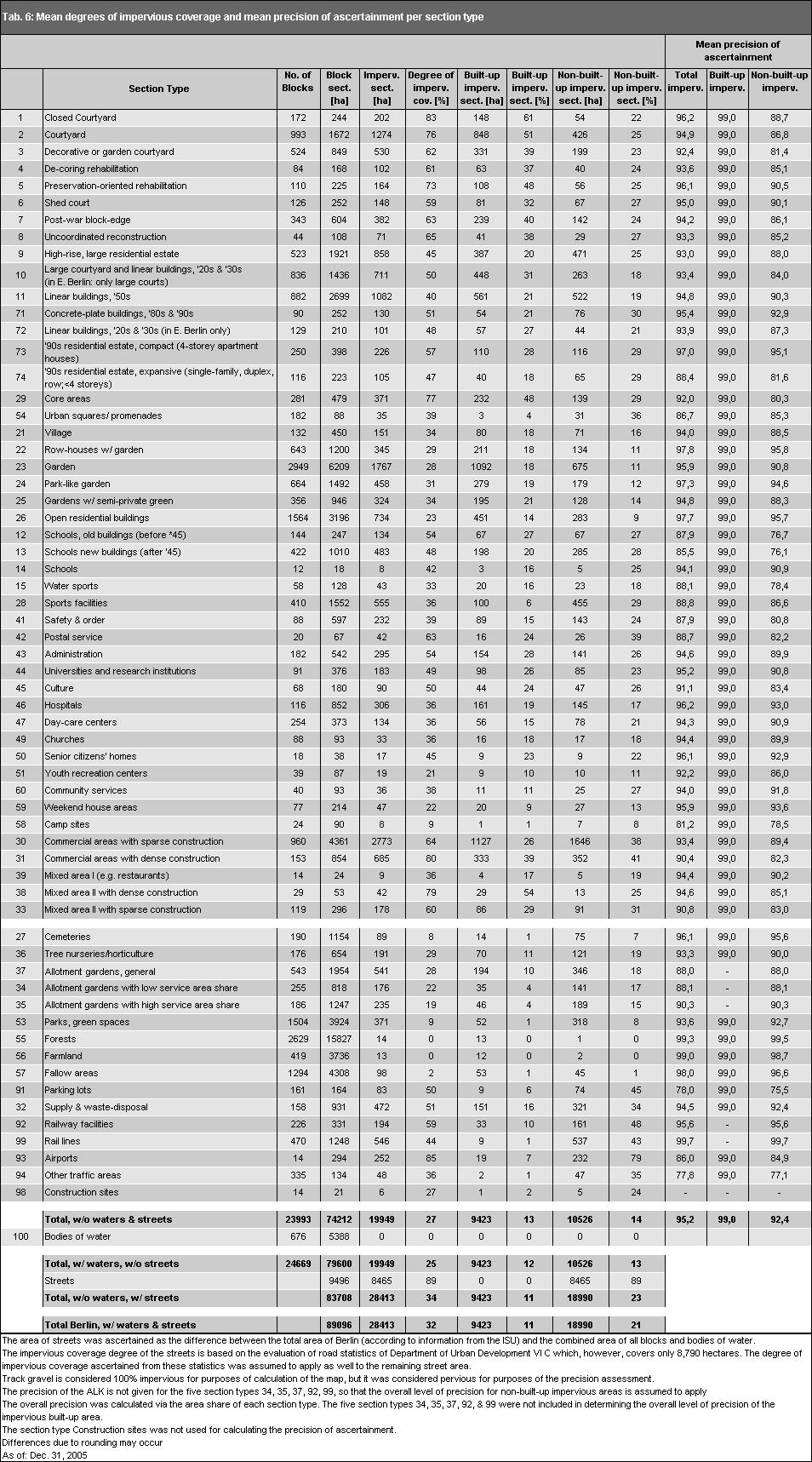
18 18
. Residential areas have an average degree of impervious coverage of 38 %.")
19 Tab. 6: Mean degrees of impervious coverage and mean precision of ascertainment per section type 19 For a better overview, the degrees of impervious coverage are also summarized for each land-use type (ISU categories). Residential areas have an average degree of impervious coverage of 38 %. The core areas have the highest mean degree of impervious coverage, with 77 %, while Forest and "Farmed fields" have the lowest. Tab. 7: Mean degrees of impervious coverage by land-use type The statistical blocks and partial blocks of Berlin (without streets and waters) are 27 % impervious, on the average. Of this, 13 % are on the impervious built-up areas, and 14 % on the impervious non-built-up areas. Including bodies of water and streets, Berlin is thus 32 % impervious. Of this, 11 % are on the impervious built-up area, and 21 % on the impervious non-built-up area. Berlin is thus one third impervious. The impervious area in turn consists of roughly equal parts of buildings, of streets, and of non-built-up impervious areas. Impervious Coverage in the Boroughs For the borough-referenced evaluation, the average degree of impervious coverage of the road surfaces was calculated. For this purpose, statistics on the pavement and road surfacing of Berlin s streets, bicycle paths and sidewalks were evaluated (SenStadt 2006).
 The borough with the lowest degree of impervious coverage is Treptow-Köpenick, with 21 %, while Kreuzberg-")
20 20 Fig. 6: Degree of impervious coverage by borough (in percent of total area w/o bodies of water) The borough with the lowest degree of impervious coverage is Treptow-Köpenick, with 21 %, while Kreuzberg- Friedrichshain and Mitte have the highest degrees, with 66 and 60 %, respectively. These two boroughs also have the highest shares of built-up areas, as a proportion of their total areas. Data on Impervious Soil Coverage in 2005 Compared with 1990 and 2001 Due to different ascertainment methods, a direct comparison between the impervious coverage values of 2001 and 2005 is possible only to a limited degree. No change in the impervious area over the course of this period of time can be ascertained from these figures. In 2001, the degree of impervious coverage in Berlin amounted to 34.7%, incl. streets and bodies of water. These data are to some extent based on evaluations of satellite images and other sources from the 80s (only in West Berlin). These mapping system were expanded to include East Berlin in 1990, and partially updated, in 2001 by means of aerial photography and topographical maps of the area. Here, use-specific flat values were assumed in some cases. Overall, the ascertainment methodology was non-uniform. The current set of maps now provides a data set obtained according to a considerably improved methodology which is uniform and completely automated. The result is that the degree of impervious coverage in 2005 amounts to 31.8%, and is thus approx. 3% below the values of However, this does not under any circumstances imply any reduction in impervious area. Tab. 8: Results of Impervious Coverage Maps in Berlin, 1990 to Total impervious Built-up impervious Non-built-up impervious
01.02 Impervious Soil Coverage (Sealing of Soil Surface) (Edition 2012)
 (Edition 2012)") Senate Department for Urban Development and the Environment 01.02 Impervious Soil Coverage (Sealing of Soil Surface) (Edition 2012) Overview Data on impervious soil coverage are regularly used in the offices
Senate Department for Urban Development and the Environment 01.02 Impervious Soil Coverage (Sealing of Soil Surface) (Edition 2012) Overview Data on impervious soil coverage are regularly used in the offices
06.07 Urban Structure Urban Structure differentiated (2011 Edition)
") Senate Department for Urban Development and the Environment 06.07 Urban Structure 06.08 Urban Structure differentiated (2011 Edition) Overview The effects of urban development upon the environment depend
Senate Department for Urban Development and the Environment 06.07 Urban Structure 06.08 Urban Structure differentiated (2011 Edition) Overview The effects of urban development upon the environment depend
Fire Mapping Chapter. Working Paper
 Fire Mapping Chapter Working Paper Version 1.0 as of September 2018 International Working Group on Satellite-based Emergency Mapping (IWG-SEM) Contents 1. FOREWORD... 3 2. IWG-SEM Fire delineation section...
ANALYSIS AND EVALUATION OF NATURE SPACE POTENTIAL IN PERI-URBAN SPACES USING REMOTE SENSING DATA AND GIS
 ANALYSIS AND EVALUATION OF NATURE SPACE POTENTIAL IN PERI-URBAN SPACES USING REMOTE SENSING DATA AND GIS Ellen BANZHAF UFZ-Centre for Environmental Research Leipzig-Halle, Permoserstr. 15, D-04318 Leipzig
06.07 Urban Structure Urban Structure Area Types Differentiated (2016 Edition)
") 06.07 Urban Structure 06.08 Urban Structure Area Types Differentiated (2016 Edition) Overview The effects of urban development upon the environment depend to a particular degree on the type and intensity
06.07 Urban Structure 06.08 Urban Structure Area Types Differentiated (2016 Edition) Overview The effects of urban development upon the environment depend to a particular degree on the type and intensity
CROWD-SOURCED REMOTE ASSESSMENTS OF REGIONAL-SCALE POST-DISASTER DAMAGE
 Eleventh U.S. National Conference on Earthquake Engineering Integrating Science, Engineering & Policy June 25-29, 2018 Los Angeles, California CROWD-SOURCED REMOTE ASSESSMENTS OF REGIONAL-SCALE POST-DISASTER
Draft Impervious Cover Reduction Action Plan for West Long Branch Borough, Monmouth County, New Jersey
 Draft Impervious Cover Reduction Action Plan for West Long Branch Borough, Monmouth County, New Jersey Prepared for West Long Branch Borough by the Rutgers Cooperative Extension Water Resources Program
B L A C K D I A M O N D D E S I G N G U I D E L I N E S for Multi-family Development
 B L A C K D I A M O N D D E S I G N G U I D E L I N E S for Multi-family Development Adopted June 18, 2009 This section of the Design and focuses on site planning and design guidance for new multi-family
BLACK/HARMONY/FAREWELL CREEK WATERSHED EXISTING CONDITIONS REPORT CHAPTER 5 IMPERVIOUS SURFACES
 BLACK/HARMONY/FAREWELL CREEK WATERSHED EXISTING CONDITIONS REPORT CHAPTER 5 IMPERVIOUS SURFACES Draft November 2009 TABLE OF CONTENTS 1.0 INTRODUCTION... 3 2.0 STUDY AREA AND SCOPE... 4 3.0 METHODOLOGY...
Draft Impervious Cover Reduction Action Plan for West New York, Hudson County, New Jersey
 Draft Impervious Cover Reduction Action Plan for West New York, Hudson County, New Jersey Prepared for the Town of West New York by the Rutgers Cooperative Extension Water Resources Program March 29, 2017
TOWN OF HILLSBOROUGH SAN MATEO COUNTY
 TOWN OF HILLSBOROUGH SAN MATEO COUNTY Planning Division 650/375-7422 Fax: 650/375-7415 1600 Floribunda Avenue Hillsborough California 94010 Administrative Review of Landscape Plans April 2017 WHAT TYPES
Brine Generation Study
 DOE/WIPP 00-2000 Brine Generation Study April 2000 Waste Isolation Pilot Plant Carlsbad, New Mexico Processing and final preparation of this report was performed by the Waste Isolation Pilot Plant Management
Reported Fires in High-Rise Structures in Selected Occupancies with and without Automatic Extinguishing Systems by Extent of Smoke Damage
 Reported Fires in High-Rise Structures in Selected Occupancies with and without Automatic Extinguishing Systems by Extent of Smoke Damage Marty Ahrens Fire Analysis and Research Division National Fire
PLANNING BOARD HEARING Miami Shores Village Town Hall Council Chambers NE 2 nd Avenue Miami Shores Workshop Date April 24, 2014
 MIAMI SHORES VILLAGE DEPARTMENT OF PLANNING & ZONING 10050 NE 2 nd Avenue Miami Shores FL 33037-2304 www.miamishoresvillage.com David A. Dacquisto AICP, Director dacquistod@miamishoresvillage.com Main
Newcourt Masterplan. November Exeter Local Development Framework
 Newcourt Masterplan November 2010 Exeter Local Development Framework Background The Exeter Core Strategy Proposed Submission sets out the vision, objectives and strategy for the development of Exeter up
THE LANDSCAPE ECOLOGICAL ASSESSMENT MODEL AND ITS APPLICATIONS
 The 5 th International Conference of the International Forum on Urbanism (IFoU) 2011 National University of Singapore, Department of Architecture Global Visions: Risks and Opportunities for the Urban Planet
Analysis of Environs of 1000 New York Street, German Methodist Episcopal Church
 Item No. 3: L-14-00028 p.1 Analysis of Environs of New York Street, German Methodist Episcopal Church Step One Historical Significance and Context According to the application for Historic Landmark Designation,
STORM WATER UTILITY FREQUENTLY ASKED QUESTIONS
 STORM WATER UTILITY FREQUENTLY ASKED QUESTIONS In 2007, the City Council adopted Ordinance No. 1155 establishing a storm water utility in the City. No fee structure was adopted at that time. The idea of
APPENDIX A SIMPLIFIED APPROACH TO STORMWATER MANAGEMENT FOR SMALL PROJECTS. In West Sadsbury Township, Chester County, Pennsylvania
 APPENDIX A SIMPLIFIED APPROACH TO STORMWATER MANAGEMENT FOR SMALL PROJECTS In West Sadsbury Township, Chester County, Pennsylvania TABLE OF CONTENTS I. Introduction 3 II. Importance of Stormwater Management
County of Fairfax, Virginia
 County of Fairfax, Virginia To protect and enrich the quality of life for the people, neighborhoods, and diverse communities of Fairfax County DATE: July 16, 2007 TO: SUBJECT: All Architects, Attorneys,
DRAFT DESIGN GUIDELINES
 IHZ Booklet #7 May 6, 2010 DRAFT DESIGN GUIDELINES CANTERBURY 7 Overview During the recent planning process for the Plan of Conservation and Development community character was identified as an important
Duplex Design Guidelines
 Duplex Design Guidelines Adopted by Council May 29, 2006 Prepared By: Table of Contents 1.0 Application and Intent 1 2.0 Areas of Application 2 3.0 Design Principles 3 4.0 Design Guidelines 4 4.1 Site
Keep the Rain, not the runoff! Residential Best Management Practice (BMP) Incentive Program Criteria
 Incentive Program Criteria") CleanSScapes Keep the Rain, not the runoff! Residential Best Management Practice (BMP) Incentive Program Criteria Howard County Office of Community Sustainability, 410-313-0678 CleanScapes Program, www.cleanwaterhoward.com
CleanSScapes Keep the Rain, not the runoff! Residential Best Management Practice (BMP) Incentive Program Criteria Howard County Office of Community Sustainability, 410-313-0678 CleanScapes Program, www.cleanwaterhoward.com
A Growing Community Rural Settlement Areas
 Town of Huntsville Official Plan Review - POLICY BACKGROUND PAPER A Growing Community Rural Settlement Areas BACKGROUND: In addition to the fully municipally-serviced Urban Settlement Area and the Hidden
STORMWATER UTILITY FREQUENTLY ASKED QUESTIONS
 STORMWATER UTILITY FREQUENTLY ASKED QUESTIONS What is Stormwater? Stormwater is water that falls to the ground during a precipitation event. When land is undeveloped or covered with vegetative surface,
Introduction Post Construction Stormwater Management Performance Requirements
 Introduction Post Construction Stormwater Management Performance Requirements The primary objective of these Post Construction Stormwater Management Performance Requirements is to minimize the downstream
Impervious Cover Reduction Action Plan for City of Vineland, Cumberland County, New Jersey
 Impervious Cover Reduction Action Plan for City of Vineland, Cumberland County, New Jersey Prepared for the City of Vineland by the Rutgers Cooperative Extension Water Resources Program May 23, 2016 Table
CITY OF URBANA STORMWATER UTILITY FEE FREQUENTLY ASKED QUESTIONS
 CITY OF URBANA STORMWATER UTILITY FEE FREQUENTLY ASKED QUESTIONS GENERAL QUESTIONS 1. What is the stormwater utility fee? A stormwater utility fee is a fee that produces revenue that is dedicated to improving
Ancient Greek and Roman planners recognized the importance of centralized gathering spaces within urban
 TEAMS Competition 2014 Urban Green Space Design Introduction Ancient Greek and Roman planners recognized the importance of centralized gathering spaces within urban areas. Early Greek agora and Roman forums
Metropolitan Area Planning Council 60 Temple Place, Boston, Massachusetts fax
 Metropolitan Area Planning Council 60 Temple Place, Boston, Massachusetts 02111 617-451-2770 fax 614-482-7185 www.mapc.org Serving the 101 Cities Towns in the Metropolitan Boston Region MEMORANDUM TO:
Chapter 1 - General Design Guidelines CHAPTER 1 GENERAL DESIGN GUIDELINES
 CHAPTER 1 GENERAL DESIGN GUIDELINES 1.0 INTRODUCTION This Publication has been developed to provide current, uniform procedures and guidelines for the application and design of safe, convenient, efficient
Raingardens. Conserving and Protecting Water L
 L-5482 08-08 Raingardens Justin Mechell, Extension Assistant, and Bruce Lesikar, Extension Program Leader for Biological and Agricultural Engineering,The Texas A&M University System A raingarden is an
Draft. Impervious Cover Reduction Action Plan for Dunellen Borough, Middlesex County, New Jersey
 Draft Impervious Cover Reduction Action Plan for Dunellen Borough, Middlesex County, New Jersey Prepared for Dunellen Borough by the Rutgers Cooperative Extension Water Resources Program September 22,
V-5 TREE PROTECTION AND LANDSCAPING REQUIREMENTS
 V-5 TREE PROTECTION AND LANDSCAPING REQUIREMENTS V-5.1 General A. Intent: It is the intent of this section to establish protective regulations for trees within the City of Milton, in order to better control
F. Driveways. Driveways which provide access to off-street parking or loading from public streets shall comply with the following:
 Section 20.945.040 General Design Standards for Surface Parking Areas. A. Review Authority. Parking lot design and drainage shall be subject to review and approval of the City Transportation Manager. B.
Research on Decision Tree Application in Data of Fire Alarm Receipt and Disposal
 Research Journal of Applied Sciences, Engineering and Technology 5(22): 5217-5222, 2013 ISSN: 2040-7459; e-issn: 2040-7467 Maxwell Scientific Organization, 2013 Submitted: October 09, 2012 Accepted: December
HEALTH SCIENCES BUILDING REDEVELOPMENT PROJECT
 INTRODUCTION In recent years, the University of Cincinnati (University) has demonstrated a commitment to identifying and implementing sustainable goals and objectives throughout University s Uptown Campuses.
Metropolitan Area Planning Council 60 Temple Place, Boston, Massachusetts fax
 Metropolitan Area Planning Council 60 Temple Place, Boston, Massachusetts 02111 617-451-2770 fax 614-482-7185 www.mapc.org Serving the 101 Cities and Towns in the Metropolitan Boston Region MEMORANDUM
SPECIFIC PLAN Requirements
 CITY OF LANCASTER PLANNING DEPARTMENT 44933 Fern Avenue, Lancaster, California 93534 (661) 723-6100 SPECIFIC PLAN Requirements Purpose The purpose of a specific plan is to provide for the logical development
Impervious Cover Reduction Action Plan for Hampton Township, Sussex County, New Jersey
 Impervious Cover Reduction Action Plan for Hampton Township, Sussex County, New Jersey Prepared for Hampton Township by the Rutgers Cooperative Extension Water Resources Program November 8, 2016 Table
Structure Fires in Hotels and Motels
 Structure Fires in Hotels and Motels John Hall Fire Analysis and Research Division National Fire Protection Association October 2006 National Fire Protection Association, 1 Batterymarch Park, Quincy, MA
Section 9 NEIGHBORHOOD DESIGN
 Section 9 NEIGHBORHOOD DESIGN City of Lancaster Comprehensive Plan D u n k i n, S e f k o & A s s o c i a t e s, I n c. NEIGHBORHOOD DESIGN INTRODUCTION There are many ways in which a neighborhood can
Chapter 19.5 LANDSCAPING REQUIREMENTS
 Chapter 19.5 LANDSCAPING REQUIREMENTS Sec. 19.5-1. Intent The intent of the landscaping requirements stated herein are as follows: To aid in stabilizing the environment's ecological balance by contribution
3.10 LAND USE SETTING PROJECT SITE EXISTING LAND USE DESIGNATIONS AND ZONING. General Plan Land Use Designations.
 This section of the Draft EIR addresses the existing land uses on and adjacent to the project site and discusses the potential impacts of the proposed project on existing land uses. Key issues addressed
Public Works and Infrastructure Committee Front Yard Parking Regulations. Transportation Services. June 8, 2017
 RE: PW22.5 Public Works and Infrastructure Committee Front Yard Parking Regulations Transportation Services June 8, 2017 1 BACKGROUND 2 HISTORY Providing parking on the boulevard and/or front yard within
Catawba Area Plan Advisory Group
 Catawba Area Plan Advisory Group Meeting #3 Natural Environment, Part I September 23, 2008 Advisory Group Meeting #3 Welcome and Introductions Review Handouts Vision Statement GDP - Environment Draft Vision
ALBERTA FOREST PROTECTION THERMAL INFRARED PROGRAM
 ALBERTA FOREST PROTECTION THERMAL INFRARED PROGRAM Eleventh Biennial USDA Forest Service Remote Sensing Applications Conference Salt Lake City, Utah April 25 Ken Dutchak, P. Biol. Reconnaissance and Remote
SIMPLIFIED APPROACH TO STORMWATER MANAGEMENT FOR SMALL PROJECTS
 SIMPLIFIED APPROACH TO STORMWATER MANAGEMENT FOR SMALL PROJECTS Introduction As required by federal and state law, the Borough of Swarthmore has adopted regulations that affect stormwater runoff and surface
SMALL PROJECTS SIMPLIFIED APPROACH
 SMALL PROJECT APPLICATION AND STORMWATER MANAGEMENT DESIGN ASSISTANCE MANUAL FOR SMALL PROJECTS IN FULTON TOWNSHIP LANCASTER COUNTY, PENNSYLVANIA SMALL PROJECTS SIMPLIFIED APPROACH Prepared By: Light-Heigel
06.05 Availability of Public, Nearresidential Green Spaces (Edition 2013)
") Senate Department for Urban Development and the Environment 06.05 Availability of Public, Nearresidential Green Spaces (Edition 2013) Overview Densely built-up urban space is characterized by high structural
Senate Department for Urban Development and the Environment 06.05 Availability of Public, Nearresidential Green Spaces (Edition 2013) Overview Densely built-up urban space is characterized by high structural
A study on the regional landscape planning framework on the relationships between urban and rural areas: case study of Tokachi region, Hokkaido, Japan
 A study on the regional landscape planning framework on the relationships between urban and rural areas: case study of Tokachi region, Hokkaido, Japan K. Yamagishi & H. Kobayashi Laboratory of Urban Planning
CONTENTS 8.0 LAND USE 8.1 GENERAL LAND USE 8.2 RESIDENTIAL 8.3 MIXED USE 8.4 COMMERCIAL 8.5 EMPLOYMENT LANDS
 8-2 Land Use 8.0 LAND USE CONTENTS 8.1 GENERAL LAND USE 8.1.1 Uses provided for in all Land Use Designations 8.1.2 Uses prohibited in Hazardous Lands, Hazardous Sites and Special Policy Areas 8.1.3 Uses
2.1 Decision Making Matrix
 2.1 Decision Making Matrix The following decision-making matrix merges the elements of architectural and historical significance and current condition within the over-arching treatment recommendation of
Landscape and fencing requirements of this Chapter shall apply to all new landscaped areas.
 Chapter 19.06. Landscaping and Fencing. Sections: 19.06.01. Purpose. 19.06.02. Required Landscaping Improvements. 19.06.03. General Provisions. 19.06.04. Landscaping Plan. 19.06.05. Completion of Landscape
CaseStudy Climate-ADAPT. Stuttgart: combating the heat island effect and poor air quality with green ventilation corridors
 CaseStudy Climate-ADAPT Stuttgart: combating the heat island effect and poor air quality with green ventilation corridors Cover design: EEA Cover photo: EEA Layout: EEA Legal notice The contents of this
Lecture: Landscape Ecology
 Borderland: Border Landscapes Across Europe 2013 Lecture: Landscape Ecology Dr Iwona Markuszewska Department of Landscape Ecology iwmark@amu.edu.pl Presentation schedule: Landscape ecology as a scientific
THE GARDEN CITY PLAN. City of St. Catharines Official Plan. City of St. Catharines
 THE GARDEN CITY PLAN City of St. Catharines Official Plan City of St. Catharines August 2010 APPROVAL INFORMATION This Official Plan of the City of St. Catharines Planning Area, known as the Garden City
Master Gardener Recommended Horticulture Best Management Practices
 Master Gardener Recommended Horticulture Best Management Practices Practices that should always be recommended: Group plants with similar needs (water, fertilizer, sun ) for easier maintenance Fertilize
Peoria has a tremendous opportunity to get sewer overflows under control and fight stormwater runoff head-on
 Peoria has a tremendous opportunity to get sewer overflows under control and fight stormwater runoff head-on The time is right to find funding solutions that address our aging infrastructure. We can enable
Chapter 10 IMPLEMENTATION RECOMMENDATIONS
 Chapter 10 IMPLEMENTATION RECOMMENDATIONS The recommended land use plan presented in the previous chapter provides a design for the attainment of the urban and rural development and open space preservation
CITY OF CYPRESS 5275 Orange Avenue Cypress, California (714) DESIGN REVIEW COMMITTEE PERMIT PROCESS
 DESIGN REVIEW COMMITTEE PERMIT PROCESS") CITY OF CYPRESS 5275 Orange Avenue Cypress, California 90630 (714) 229-6720 DESIGN REVIEW COMMITTEE PERMIT PROCESS 1. Discuss project with Planning staff to determine zoning regulations, any unusual characteristics
CITY OF CYPRESS 5275 Orange Avenue Cypress, California 90630 (714) 229-6720 DESIGN REVIEW COMMITTEE PERMIT PROCESS 1. Discuss project with Planning staff to determine zoning regulations, any unusual characteristics
HUDSON VALLEY REGIONAL COUNCIL 3 Washington Center, Newburgh NY
 PROJECT AREA: HYDE PARK HUDSON VALLEY REGIONAL COUNCIL 3 Washington Center, Newburgh NY 12550 http://www.hudsonvalleyregionalcouncil Insert aerial site photo with streets labeled GREEN INFRASTRUCTURE CONCEPT
Understanding total measurement uncertainty in power meters and detectors
 Understanding total measurement uncertainty in power meters and detectors Jay Jeong, MKS Instruments. Inc. INTRODUCTION It is important that users of calibrated power meters and detectors understand and
Minnesota Department of Natural Resource - Natural Resource Guidance Checklist Conserving Natural Resources through Density Bonuses
 Minnesota Department of Natural Resource - Natural Resource Guidance Checklist Conserving Natural Resources through Density Bonuses NRDB Why Use Density Bonuses & This Checklist Local units of government
Option 1 Turf shall not exceed 40 percent of the landscapable area. Turf shall not be installed on slopes greater than 4:1.
 WaterSense Water Budget Approach and Tool I. Introduction On May 22, 2008, EPA released a draft specification for water-efficient single-family new homes (www.epa.gov/watersense/specs/homes.htm). To meet
5. Land use database applications
 48 Towards an urban atlas 5. Land use database applications The Murbandy/Moland project is a continuously evolving activity. To date, the territorial data sets have been completed and validated for 25
Follow the Drop. Activity Overview Students observe and collect information about water runoff on their school property.
 Follow the Drop Activity Overview Students observe and collect information about water runoff on their school property. Objective Students will: 1. Practice observation and investigative skills 2. Survey
DESIGN REVIEW COMMITTEE AGENDA ITEM
 DESIGN REVIEW COMMITTEE AGENDA ITEM AGENDA DATE: OCTOBER 3, 2012 TO: Chair Woollett and Members of the Design Review Committee THRU: FROM: SUBJECT: Leslie Aranda Roseberry, Planning Manager Daniel Ryan,
Swatara Township Stormwater Program. 1. There are no storm sewers on or near my property. Why should I pay a fee?
 1. There are no storm sewers on or near my property. Why should I pay a fee? All properties produce stormwater runoff that must be managed by the Township. Even if your property has never flooded and there
City of Petersburg, VA Stormwater Utility Frequently Asked Questions
 Q. What is stormwater runoff? A. Stormwater runoff is the water that flows off roofs, driveways, parking lots, streets and other hard surfaces during rain storms. Stormwater runoff is also the rain that
Green Infrastructure and Low-Impact Development Technologies
 Green Infrastructure and Low-Impact Development Technologies The guiding principles of these technologies is to manage stormwater at their sources using natural means, and establish conditions so that
Chesapeake Bay Critical Area Conservation Plan
 The Maryland-National Capital Park and Planning Commission Prince George s County Planning Department Development Review Division 301-952-3530 Note: Staff reports can be accessed at www.mncppc.org/pgco/planning/plan.htm.
CITY OF HOLLY SPRINGS STORMWATER UTILITY FREQUENTLY ASKED QUESTIONS
 CITY OF HOLLY SPRINGS STORMWATER UTILITY FREQUENTLY ASKED QUESTIONS GENERAL What is a Stormwater Utility and why is it needed in Holly Springs? A Stormwater Utility is an entity responsible for the daily
CHAPTER 13 DESIGN GUIDELINES
 CHAPTER 13 DESIGN GUIDELINES Section 1300.00 Section 1300.01 Design Guidelines Purpose The purposes of this section are to: A. The purpose of this Section is to establish procedures and standards to serve
150 Eighth Street Zoning By-law Amendment Application Preliminary Report
 REPORT FOR ACTION 150 Eighth Street Zoning By-law Amendment Application Preliminary Report Date: March 27, 2019 To: Etobicoke York Community Council From: Director, Community Planning, Etobicoke York District
CITY OF CLEVELAND GREEN DESIGN GUIDELINES
 CITY OF CLEVELAND GREEN DESIGN GUIDELINES SEPTEMBER 18, 2008 PROJECT COMPLIANCE PATH: 1. Approved master plan 2. Approved design district boundaries 3. Approved district design guidelines, Green design
ATTACHMENT. To the west, north, and east of the block, primarily singlefamily detached residential patterns, with some townhouses, predominate.
 COMMENT / REVISION MATRIX (as of ) for Washington and Kirkwood Special GLUP Study "Plus" and Concept Plan 1 2 Resolve inconsistency between American Legion site area noted in Map 1 1.36 AC 1.29 AC and
Draft. Impervious Cover Reduction Action Plan for Fair Haven, Monmouth County, New Jersey
 Draft Impervious Cover Reduction Action Plan for Fair Haven, Monmouth County, New Jersey Prepared for Fair Haven by the Rutgers Cooperative Extension Water Resources Program June 10, 2016 Table of Contents
Rebate Amount for Lawn Conversions. $150 (300 ft² LOTS < 4,750 ft²) $250 (500 ft² LOTS 4,750 ft²)
 $250 (500 ft² LOTS 4,750 ft²)") CASH FOR GRASS EXISTING HOME CONVERSIONS REBATE PROGRAM This program is subject to change without notice and is subject to the availability of funding. Program Goal: To encourage a permanent reduction
CASH FOR GRASS EXISTING HOME CONVERSIONS REBATE PROGRAM This program is subject to change without notice and is subject to the availability of funding. Program Goal: To encourage a permanent reduction
What is stormwater runoff? Why is it a problem? Available Financial Incentives for Stormwater BMP s Downspout Disconnection - up to $20
 What is stormwater runoff? Stormwater is any form of natural precipitation (including ice and snow melt) that flows across undeveloped or developed land. In a natural setting, a majority of the water seeps
RESEARCH HIGHLIGHT. Technical Series Urban Heat Island Mitigation Measures and Regulations in Montréal and Toronto
 RESEARCH HIGHLIGHT May 2014 Technical Series 14-100 Urban Heat Island Mitigation Measures and Regulations in Montréal and Toronto INTRODUCTION The Heat Island Research Group of the Department of Geography
DESIGN REVIEW COMMITTEE AGENDA ITEM
 DESIGN REVIEW COMMITTEE AGENDA ITEM AGENDA DATE: OCTOBER 17, 2012 TO: Chair Woollett and Members of the Design Review Committee THRU: FROM: SUBJECT: Leslie Aranda Roseberry, Planning Manager Daniel Ryan,
Official Journal of the European Union. (Non-legislative acts) REGULATIONS
 REGULATIONS") 19.6.2015 L 154/1 II (Non-legislative acts) REGULATIONS COMMISSION DELEGATED REGULATION (EU) 2015/942 of 4 March 2015 amending Delegated Regulation (EU) No 529/2014 supplementing Regulation (EU) No 575/2013
19.6.2015 L 154/1 II (Non-legislative acts) REGULATIONS COMMISSION DELEGATED REGULATION (EU) 2015/942 of 4 March 2015 amending Delegated Regulation (EU) No 529/2014 supplementing Regulation (EU) No 575/2013
Team number Page 1 of Canon Envirothon Soils Station Test. Soils and Climate Change
 Team number Page 1 of 9 2006 Canon Envirothon Soils Station Test Soils and Climate Change There are many kinds of soil on the surface of the earth. The kind of soil that is present at a given location
Fire Sprinklers Working Group Final Report
 Introduction The Building Act received Royal Assent on March 25, 2015. The Act aims to establish more consistent building requirements across British Columbia and create a more robust and modern building
Transportation Research Center
 Increasing Design Flexibility in the AASHTO Green Book Your Department Name Presentation to AASHTO Subcommittee on Design Doug Harwood, MRIGlobal July 2017 Transportation Research Center Resolution of
ARTICLE 6: Special and Planned Development Districts
 ARTICLE 6: Special and Planned Development Districts 6-10 Traditional Neighborhood Development (TND) District 6-10.10 Purpose and Intent The Traditional Neighborhood Development (TND) District provides
River Friendly Landscape Program Frequently Asked Questions (FAQs) December 2016
 December 2016") 1. What plants can I use in my water-efficient landscape? The River Friendly Landscape Rebate Program does not require particular plants, only that when fully mature, the plants cover at least fifty percent
1. What plants can I use in my water-efficient landscape? The River Friendly Landscape Rebate Program does not require particular plants, only that when fully mature, the plants cover at least fifty percent
tinyan lee the hastings experience masterplan : hastings corridor individual design sustainable urbanism : the hastings corridor
 tinyan lee the hastings experience masterplan : hastings corridor individual design Research Context Managing urban growth in Burnaby has become an increasing challenge. Burnaby currently has an estimated
Site design measures. Chapter. This Chapter explains how site design measures can reduce the size of your project s stormwater treatment measures.
 Chapter 4 Site Design Measures This Chapter explains how site design measures can reduce the size of your project s stormwater treatment measures. Site design measures for water quality protection are
CITY CLERK. Parkland Acquisition Strategic Directions Report (All Wards)
") CITY CLERK Clause embodied in Report No. 10 of the, as adopted by the Council of the City of Toronto at its meeting held on November 6, 7 and 8, 2001. 10 Parkland Acquisition Strategic Directions Report
CITY CLERK Clause embodied in Report No. 10 of the, as adopted by the Council of the City of Toronto at its meeting held on November 6, 7 and 8, 2001. 10 Parkland Acquisition Strategic Directions Report
Cities and Situations
 Cities and Situations after 20 years a new Plan for Bologna Twenty years after the last general urban plan, Bologna has commenced the programme for the approval of a new instrument governing the territorial
DETECTION AND MONITORING OF ACTIVE FIRES USING REMOTE SENSING TECHNIQUES
 DETECTION AND MONITORING OF ACTIVE FIRES USING REMOTE SENSING TECHNIQUES Source: Unknown n.d., http://www.hotrodsandclassics.net/featuredpictures/featurepictures2.htm. by Claire Riddell DETECTION AND MONITORING
Analysis of Landscape Character for Visual Resource Management 1
 Analysis of Landscape Character for Visual Resource Management 1 Paul F. Anderson 2/ Abstract: Description, classification and delineation of visual landscape character are initial steps in developing
Draft Impervious Cover Reduction Action Plan for Newark, Essex County, New Jersey Volume 2
 Draft Impervious Cover Reduction Action Plan for Newark, Essex County, New Jersey Volume 2 Prepared for the City of Newark by the Rutgers Cooperative Extension Water Resources Program April 16, 2018 Table
Saying Mahalo to Solar Savings: A Billing Analysis of Solar Water Heaters in Hawaii
 Saying Mahalo to Solar Savings: A Billing Analysis of Solar Water Heaters in Hawaii Jenny Yaillen, Evergreen Economics Chris Ann Dickerson, CAD Consulting Wendy Takanish and John Cole, Hawaii Public Utilities
Town of Washington Master Plan & Regulatory Audit: Interim Results
 Town of Washington Master Plan & Regulatory Audit: Interim Results May 20, 2008 Presented by: 30 Bank Street Lebanon, NH 03766 www.uvlsrpc.org Introduction & Purpose Compare the Master Plan to the regulations
MIDTOWN MIXED-USE VILLAGE. TECHNICAL DATA SHEET COMPONENT C-1 FOR PUBLIC HEARING - PETITION NUMBER Project No RZ1.1. Issued.
 N MIDTOWN MIXED-USE VILLAGE TECHNICAL DATA SHEET COMPONENT C- FOR PUBLIC HEARING - PETITION NUMBER 04-00 Project No. 496 Issued Revised SCALE: " = 0' N 0 0 0 40 RZ. c GENERAL PROVISIONS: a. SITE LOCATION.
Housing and Coach House Guidelines - Ladner
 Housing and Coach House Guidelines - Ladner Policy D.8: Encourage Compatible Housing Design Encourage housing design that is sensitive to existing single family housing neighbourhoods by requiring a design
FNGLA Landscape Maintenance Manual Fertilization
 How to Fertilize Fertilizer should be broadcast uniformly over the desired areas of the landscape. Consideration shall be given to root location, fertilization objectives and plant species. Areas where