City of Tacoma Planning Commission
|
|
|
- Herbert Henderson
- 5 years ago
- Views:
Transcription
1 City of Tacoma Planning Commission Sean Gaffney, Chair Scott Winship, Vice-Chair Chris Beale Donald Erickson Benjamin Fields Tina Lee Alexandria Teague Erle Thompson Stephen Wamback AGENDA MEETING: Regular Meeting TIME: Wednesday, January 8, 2014, 4:00 p.m. (Note: Rescheduled from January 1, 2014) LOCATION: Room 335, Tacoma Municipal Building (Note: Change of location; not in Room 16) 747 Market Street, Tacoma, WA A. Call to Order B. Quorum Call C. Approval of Minutes Regular Meeting and Field Trip on December 18, 2013 D. Discussion Items 1. Tacoma LINK Expansion Update Sound Transit staff will provide an update of the project and seek the Commission s feedback on the selection of a preferred alignment for environmental impact analysis purposes. (See Agenda Item D-1 ; Lihuang Wung, , lwung@cityoftacoma.org) 2. Point Defiance Park Development Regulation Agreement Policy (Annual Amendment # ) Review staff analysis of the application and, if appropriate, authorize the distribution of the proposal for public review. (See Agenda Item D-2 ; Elliott Barnett, , elliott.barnett@cityoftacoma.org) 3. Affordable Housing Policy and Code Amendments (Annual Amendment # ) Review staff analysis of the application and proposed code language. (See Agenda Item D-3 ; Elliott Barnett, , elliott.barnett@cityoftacoma.org) 4. Open Space Habitat and Recreation Element (Annual Amendment # ) Review staff analysis of the application and, if appropriate, authorize the distribution of the proposal for public review. (See Agenda Item D-4 ; Elliott Barnett, , elliott.barnett@cityoftacoma.org) 5. Sustainability Code Amendment (Annual Amendment # ) Review staff analysis of the application and proposed code language. (See Agenda Item D-5 ; Stephen Atkinson, , satkinson@cityoftacoma.org) 6. Status of 2014 Annual Amendment Review status of 2014 Annual Amendment. (See Agenda Item D-6 ; Lihuang Wung, , lwung@cityoftacoma.org) The City of Tacoma does not discriminate on the basis of disability in any of its programs, activities, or services. To request this information in an alternative format or to request a reasonable accommodation, please contact the Planning and Development Services Department at (253) (voice) or (253) (TTY). 747 Market Street, Room 345 Tacoma, WA (253) FAX (253)
2 Planning Commission Agenda Wednesday, January 8, 2014 Page 2 E. Communication Items & Other Business (a) Transportation Commission s Roles and Responsibilities (See Agenda Item E-1 ) (b) Sound Transit Open House on Tacoma LINK Light Rail Expansion Project, Thursday, January 9, 2014, 4:00 to 7:00 p.m., Stadium High School Auxiliary Gym, 111 North E Street, Tacoma. (c) Planning Commission meeting, January 22, 2014 (rescheduled from January 15, 2014), 4:00 p.m., Council Chambers; agenda includes: Public Hearing Hilltop Subarea Plan and EIS Public Hearing Temporary Homeless Camp Permitting Process Proposed Point Ruston Mixed-Use Center Urban Forestry Landscaping Code Update Affordable Housing Policy and Code Amendments Mixed-Use Centers Code Review (d) Infrastructure, Planning and Sustainability Committee meeting, January 22, 2014, 4:30 p.m., Room 16; agenda includes: 2013 Mobility Master Plan Accomplishments Downtown on the Go F. Adjournment
3 City of Tacoma Planning Commission Sean Gaffney, Chair Scott Winship, Vice-Chair Chris Beale Donald Erickson Benjamin Fields Tina Lee Alexandria Teague Erle Thompson Stephen Wamback Part I. Time: Field Trip MINUTES (draft) Wednesday, December 18, 2013, 2:30 p.m. Location: Point Ruston LLC, 5219 N. Shirley St., Suite 100, Ruston, WA Present: Absent: Sean Gaffney (Chair), Scott Winship (Vice-Chair), Chris Beale, Tina Lee, Alexandria Teague, Erle Thompson, Stephen Wamback Donald Erickson, Benjamin Fields A. CALL TO ORDER AND QUORUM CALL Chair Gaffney called the meeting to order at 2:35 p.m. and declared a quorum present. B. FIELD TRIP Point Ruston Mixed-Use Center (Annual Amendment Application # ) Loren Cohen of Point Ruston LLC and J. J. McCament of McCament & Rogers hosted the Planning Commission s visit of the Point Ruston development site. Mr. Cohen provided an introduction of the company, the history of the old ASARCO site, the company s development plan for the site, and the intent of the request for designating that portion of the site within the City as a Mixed-Use Center. Discussion ensued as the Commissioners toured the site on a van. The field trip ended at 3:30 p.m. and the Commission took a recess. Part II. Time: Regular Meeting Wednesday, December 18, 2013, 4:00 p.m. Location: Visibility Center, 9th FL, Tacoma Municipal Building, 747 Market Street Present: Absent: Sean Gaffney (Chair; excused at 6:00 p.m.), Scott Winship (Vice-Chair; excused at 4:25 p.m.), Chris Beale, Donald Erickson, Tina Lee, Alexandria Teague, Erle Thompson, Stephen Wamback Benjamin Fields C. RECONVENE AND APPROVAL OF MINUTES Chair Gaffney reconvened the meeting at 4:00 p.m. and declared a quorum present. The minutes of the regular meeting on December 4, 2013 were approved as submitted. D. DISCUSSION ITEMS 1. Point Ruston Mixed-Use Center (Annual Amendment Application # ) Elliott Barnett, Planning Services Division, presented the revised staff analysis on the application for designating that portion of the Point Ruston development site within the City as a Mixed-Use Center (MUC), largely in response to the Commission s inquiries and suggestions made at the previous meeting on October 16, He indicated that the proposed MUC designation meets the policy intent and direction contained in the Comprehensive Plan in most regards, with the possible exceptions of providing affordable housing options and of providing alternatives to car travel particularly transit. Mr. Barnett stated staff s view that the issues of the application are understood, and recommended that the proposal 747 Market Street, Room 345 Tacoma, WA (253) FAX (253)
4 Planning Commission Minutes Regular Meeting and Field Trip, Wednesday, December 18, 2013 Page 2 be released for formal public comment. He also passed out a memo prepared by the applicant which discusses these issues. (Vice-Chair Winship was excused at 4:25 p.m.) The Commissioners were supportive of sending the application and staff report out for public comment, though some reiterated their questions or concerns about the housing affordability issue, the fact that the site is not yet developed, the market reality for the site, the lack and uncertainty of current and future transit services, and that planning for 500 parking spaces over and beyond the code requirement is against the principle of multimodal transportation, among other issues. The Commissioners voted unanimously to move the application and the revised staff analysis report as presented, along with the applicant s memo, for public review in February-March Urban Forestry Landscaping Code Update (Annual Amendment Application # ) Elliott Barnett, Planning Services Division, provided a progress report on the code development in response to the Commission s direction and questions from the November 20, 2013 meeting, as well as on ongoing stakeholder outreach. He stated that the main issues on which staff have been working include Small, Medium, Large Tree definitions and sliding scale; minimum tree spacing, soil volumes and unpaved areas; the self-managed agencies approach (a.k.a., Landscape Master Plans); determining appropriate key corridors in industrial districts for purposes of adding Street Tree requirements; and determining appropriate ratios for incentives and bonuses. He stated that staff felt it made sense to provide this update now in order to get the Commission s direction before drafting proposed code language. He indicated that staff will continue the code development effort and conduct some road testing of the current proposal with hypothetical development proposals. Mr. Barnett also stated that staff anticipate the need to make some adjustments to the code s existing landscaping distribution requirements in order to ensure that the Small, Medium, Large Tree Size approach will function as intended. The Commissioners generally concurred with staff s approach to date. They reiterated their concern in regards to inspection, enforcement and maintenance and asked staff to continue to work with Code Enforcement on that issue. They discussed that it would be desirable to incentivize private property owners to help maintain trees on public rights-of-way; expressed interest in seeing a proposal for street tree requirements for M-2 and PMI districts; and suggested that the width of planting strips in the current proposal, i.e., 4 feet, is not adequate for larger trees. 3. Temporary Homeless Camps Permitting Process John Harrington, Development Services Division, facilitated the Commission s continued review of the proposed amendments to the Tacoma Municipal Code intended to establish the permitting process and development standards for temporary homeless camps run by religious organizations. He presented the revised version of the proposed code amendments, largely in response to the Commission s inquiries and suggestions made at the previous meeting on November 20, (Chair Gaffney was excused at 6:00 p.m., and Commissioner Erickson was designated as the Chair Pro Tem to preside over the meeting.) Discussion ensued. The Commission made the following modifications to the revised version of the proposed code amendments: (a) allow no more than two camps of up to 100 residents each operating within the City at any given time; (b) require any camp be located within ¼ mile of a transit stop; (c) clarify that a camp may only return to the same church owned site, not to the same parcel of land, after the allowed time lapse; and (d) require minimum 2-foot separation on side and rear of tents. The Commission unanimously approved the proposed code amendments, with said modifications, for public review purposes and set January 22, 2014 as the date for a public hearing.
5 Planning Commission Minutes Regular Meeting and Field Trip, Wednesday, December 18, 2013 Page 3 4. Hilltop Subarea Plan and EIS Brian Boudet, Manager of the Planning Services Division, facilitated the Commissioners review of the Revised Draft Hilltop Subarea Plan, dated December 2013, compiled with Appendix A Proposed Amendments to Tacoma Municipal Code Chapter 13.06: Zoning. It was noted that this version was largely the same as the version handed out at the last meeting on December 4, 2013, with the primary changes being the incorporation of some additional background information and revised maps and the inclusion of the limited, proposed code changes. Upon completing the review, the Commission unanimously approved the document for public review purposes and set January 22, 2014 as the date for a public hearing. 5. Mixed-Use Centers Code Review (Annual Amendment Application # ) Brian Boudet, Manager of the Planning Services Division, provided an update on the Mixed-Use Centers Code Update project, which is designed to evaluate the existing regulatory standards applicable within the centers and identify potential barriers to achieving the desired development. The project focuses on evaluation of the existing development requirements applicable within the Neighborhood Mixed-Use Centers, and particularly those applicable to mixed-use projects in the core of these districts. Mr. Boudet indicated that prototype development scenarios are being utilized to help identify potential barriers and alternatives that could be pursued, either on a temporary or permanent basis. He presented the schematic plans for the prototype building form and layout. The prototype is envisioned as a mixeduse project located on a relatively small lot (100-feet wide) along a Core Pedestrian Street within a Neighborhood Mixed-Use Center. Three test sites for the prototype project have been selected from three centers Proctor, Hilltop, and 56th & South Tacoma Way. These sites reflect different areas of the City and different circumstances in relation to certain standards, such as stormwater requirements. E. COMMUNICATION ITEMS AND OTHER BUSINESS (a) Lihuang Wung, Planning Services Division, provided the following information: Agenda for the Transportation Commission and Bicycle Pedestrian Technical Advisory Group joint meeting, December 18, 2013 Agenda for the Planning Commission meeting, January 8, 2014 Agenda for the Infrastructure, Planning and Sustainability Committee meeting, January 8, 2014 (b) Mr. Wung presented Planning Commission Year in Review 2013, summarizing the Commission s activities and accomplishments in He expressed staff s appreciation to the Commissioners for their service and advice. The Commissioners also commended staff for their professionalism and dedication. (c) Mr. Boudet reported that the South Downtown Subarea Plan was adopted by the City Council on December 17, (d) Commissioner Lee stated that she will be attending a class at the University of Washington Tacoma on 10 consecutive Wednesdays, starting January 8, 2014, and will be missing or only attending part of the next few meetings until early March. F. ADJOURNMENT The meeting was adjourned at 7:04 p.m.
6
7 Agenda Item D-1 City of Tacoma Planning and Development Services To: Planning Commission From: Lihuang Wung, Planning Services Division Subject: Tacoma Link Expansion Update Meeting Date: January 8, 2014 Memo Date: January 2, 2014 At the Planning Commission s meeting on January 8, 2014, Sound Transit staff will provide an update of the Tacoma Link Light Rail Expansion project. As a background, in May 2013, after gathering feedback from Tacoma citizens and the City Council, the Sound Transit Board of Directors identified the North Downtown Central Corridor (Hilltop via the Stadium District) as the preferred corridor for the potential expansion of Tacoma Link, subject to securing necessary funding. Sound Transit, in cooperation with the City of Tacoma and Pierce Transit, has begun the next phase of the project to define possible routes and conduct a preliminary evaluation of them. The Sound Transit Board may select an alignment or alignments to further study in the environmental phase of the project as early as February 27, To meet Sound Transit s timeline, the City Council is scheduled to review public comments on the project at the Study Session on January 21, 2014, and may consider making a recommendation to the Sound Transit Board in the following week. The presentation on January 8 is an opportunity for the Commission to provide comments and feedback on the potential expansion route, which would then be incorporated in the public comments to be reviewed by the City Council on January 21. The Commission may also consider making a formal recommendation to the City Council via a letter of recommendation. For more information, the Commissioners are encouraged to attend a Sound Transit Open House scheduled for Thursday, January 9, 2014, from 4:00 to 7:00 p.m., in the Stadium High School Auxiliary Gym (111 North E Street, Tacoma), or visit the project website at: If you have any questions, please contact me at or lwung@cityoftacoma.org. c: Peter Huffman, Director 747 Market Street, Room 345 Tacoma, WA (253) FAX (253)
8
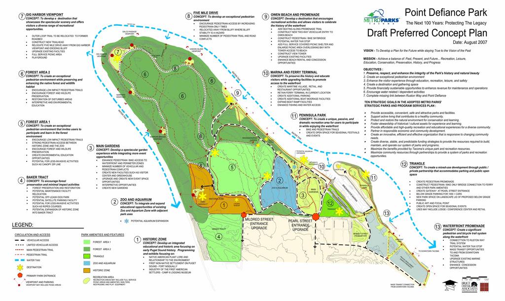
9 Agenda Item D-2 City of Tacoma Planning and Development Services To: Planning Commission From: Elliott Barnett, Planning Services Division Subject: Application # Point Defiance Park Policy and Code Meeting Date: January 8, 2014 Memo Date: January 2, 2014 At the January 8 th meeting, staff will present draft policy and code changes, along with a draft staff report, addressing Metro Parks Tacoma s (MPT) application to amend the Comprehensive Plan and development regulations in support of their Destination Point Defiance plan. The intent of the application is to provide a clear City review pathway for MPT, as a precursor to a future application for City permits. In this case, City staff recommended consideration of the Development Regulation Agreement (DRA) approach as a process intended to allow a direct application of the City s Comprehensive Plan policies to large, signature development proposals. While there is strong policy support for the plan, it s combination of features makes it somewhat unique, particularly in the context of the site s R-1 Single-family Residential zoning designation. The park plan includes commercial, lodging, educational and other features in keeping with the character of the park as a major destination. These features are not typical in single-family districts, and would require a discretionary review process in any scenario. The proposed amendments would lay the groundwork for a future DRA application by establishing clear policy support and code authority to utilize the City s DRA process to review plans for Point Defiance Park. The park has existed with the single-family Comprehensive Plan designation for many years, and is already characterized by large, destination features such as the zoo. The DRA process is already in code and MPT could potentially use it without the changes proposed in this application. However, MPT wishes to increase their certainty in regards to the review process, before proceeding. Alternatively, should MPT pursue a different review approach, such as Conditional Use Permits or a Rezone, the policy language proposed through this application would also lend support to those applications. Attached is a proposed staff report and supporting exhibits for this application. Staff will request any guidance from the Commission, and if the Commission agrees will request authorization to release the package for continued public outreach and review. If you have any questions, please contact me at or elliott.barnett@cityoftacoma.org. Attachments (5) c: Peter Huffman, Interim Director 747 Market Street, Room 345 Tacoma, WA (253) FAX (253)
10
11 2014 Annual Amendment Staff Analysis Report Application No.: Proposed Amendment: Applicant: Location & Size of Area: Current Land Use & Zoning: Neighborhood Council Area: Staff Contact: Date of Report: (Planning Commission review date; draft or final) Point Defiance Park Policy and Code Metro Parks Tacoma, Curtis Hancock Point Defiance Park, 768 acres R-1 Single-Family Residential District, S-4, S-5 and S-15 Shoreline Districts West End Elliott Barnett, Planning Services Division (253) January 8, 2014 (draft) I. Description of the Proposed Amendment: 1. Describe the proposed amendment, including the existing and proposed amendatory language, if applicable. Metro Parks Tacoma s (MPT) long range plan and vision for the 768-acre park, generally referred to as Destination Point Defiance, was developed through a multi-year, broadly inclusive public process. The conceptual plan for Point Defiance Park enjoys very consistent, strong public and stakeholder support and was officially approved by the MPT Board in The Parks District has submitted this application, which would add recognition to the City s Comprehensive Plan for Destination Point Defiance and for the unique role that Point Defiance Park plays as a significant citywide destination, as a preparatory step to submitting applications for City permits. The proposal would also clarify potential City permitting pathways that MPT could utilize, including the City s Development Regulation Agreement (DRA) process. Specifically, this amendment would add a new policy to the Open Space Habitat and Recreation Element of the Comprehensive Plan expressing support for Destination Point Defiance and recognizing the unique role and destination function that Point Defiance Park plays. In addition, the proposal would modify the Tacoma Municipal Code (TMC) Parks, recreation and open space section by clarifying that the DRA process is available for Parks, Recreation and Open Space land uses. TMC provides guidance on permitting requirements for park and recreation uses, and makes a distinction between park features that are allowed by right in residential zones, and larger or more intensive park and recreation features that require a Conditional Use Permit. While the DRA process is also currently available to park, recreation and open space uses, it is currently not explicitly cited in TMC (see Exhibit D). Annual Amendment Application # Page 1 of 9 Staff Report ( )
12 2. Describe the intent of the proposed amendment and/or the reason why it is needed. This application is a preliminary step intended to establish a clear policy and code framework for MPT to utilize a DRA for Point Defiance Park. MPT staff have indicated that they intend to submit a DRA application within the next year. MPT s Point Defiance Park conceptual plan, the outcome of a multi-year planning effort, recognizes that the park functions not only as a local attraction but also as a destination for the people of the city and region. The plan includes commercial, educational and recreational features (including the zoo, a lodge, eating establishments, gift shops, a visitor s center, additional pavilion buildings, a farmers market, entertainment and educational facilities, and bike and kayak rental facilities) that broaden the use of the park and expand its function as a unique destination. While the character of most of the park would remain essentially unchanged, the plan calls for an increased intensity and range of activities in some areas particularly in the southeast corner of the park. Plans for this area, referred to as the Triangle, include a mixed-use development with educational, conference center, commercial, parking and lodging elements. The Triangle area is considered appropriate for this type of activity due to its location at the edge of the park adjacent to Point Ruston, the Breakwater Marina and the City of Ruston; and, because it is already developed with MPT maintenance facilities, batting cages, racetrack, and the Tacoma School District s Science and Math Institute (SAMI). The majority of the park is within the R-1 Single-family Dwelling District (see Exhibit A). Under that zoning designation, the more intensive land uses would require a Conditional Use Permit (CUP), and the mixed-use aspects could potentially not be considered to be permitted through the CUP process. Alternatively, consideration could be given to rezoning the park to a zoning designation that allows mixed-use development. This approach would be complicated by the fact that there is currently no zoning district that provides a clear fit. Tacoma s residential zoning districts are structured to incorporate parks, recreation and open space, and a mixed-use or commercial designation would not reflect the park and open space intent. Thus, despite the established character of the park as including major destination features such as the zoo, a more flexible City review process is appropriate. Given the Point Defiance Park vision and intent, and the City s zoning and land use approach, the DRA process is an appropriate City review process. DRAs, as laid forth in TMC , provide an optional process for direct application of the Comprehensive Plan s policies to projects meeting the criteria of that section. A flexible review process intended for large, strategic development proposals, DRAs fit the scope and scale of MPT s plans for Point Defiance Park. DRAs also provide ample public notice, a mechanism to determine appropriate conditions of approval, and are approved directly by the City Council. 3. Describe the geographical areas associated with the proposed amendment. Include such information as: location, size, parcel number(s), ownership(s), site map, site characteristics, natural features, current and proposed Comprehensive Plan land use designations, current and proposed zoning classifications, and other appropriate and applicable information for the affected area and the surrounding areas. The 768-acre park is located at the northern end of the peninsula that forms north Tacoma. Established over 125 years ago, the park is owned by the City of Tacoma and managed by MPT. Point Defiance Park is bordered by the Puget Sound on three sides, and by the Cities of Ruston and Tacoma along its southern boundary, including the Point Ruston Development on its southeastern Annual Amendment Application # Page 2 of 9 Staff Report ( )
13 corner. It is largely forested, ringed by shorelines, and includes a range of recreational, cultural, educational and maintenance facilities. The park is also the location of the Tacoma Yacht Club, the Vashon Island ferry station, eating establishments, boating facilities, and Tacoma School District s Science and Math Institute (SAMI) campus. The park is zoned R-1 Single-Family Residential District, and S-4 Point Defiance Park - Natural, S-5 Point Defiance Park - Urban Conservancy, and S-15 Point Ruston/Slag Peninsula Shoreline Districts. The Comprehensive Plan land use designation is Low Intensity and Shoreline. The site includes the following parcel numbers: , , , , , and Provide any additional background information associated with the proposed amendment. This proposal builds on MPT s planning efforts as well as four recent City initiatives: In 2008, the City Council adopted the Open Space Habitat and Recreation Element which is the City s policy direction for parks, recreation and open space. In 2010, the City created TMC Development Regulation Agreements which established an alternative process for major projects in key locations, including on public sites larger than 5 acres in size. DRAs are not available in Shoreline Districts. In 2011, the City created TMC Parks, recreation and open space which established that those uses are generally Permitted outright in residential zones, but that major features likely to generate neighborhood impacts would be Conditional Uses. This update simplified the review process for most park projects, but stopped short of explicitly establishing a process for a large, complex park sites like Point Defiance Park. As part of the 2014 Annual Amendments, updates are separately being proposed to the Open Space Habitat and Recreation Element. One objective of those updates is to provide additional guidance on how park and open space planning efforts for specific areas of the City should be considered. The proposal includes the addition to the Element of a new section indicating that plans listed therein are supported by the City s Comprehensive Plan. This proposal links these initiatives together by updating the Open Space Habitat and Recreation Element to reflect and support MPT s Destination Point Defiance plan, and by clarifying the role that DRAs can play for park, recreation and open space land uses. Annual Amendment Application # Page 3 of 9 Staff Report ( )
14 II. Analysis of the Proposed Amendment: 1. How does the proposed amendment conform to applicable provisions of State statutes, case law, regional policies, the Comprehensive Plan, and development regulations? The proposed policy and code amendments are consistent with the applicable provisions of State, regional and local law and policy. By furthering the enhancement of one of Tacoma s signature parks, this proposal supports the Comprehensive Plan. Open Space Habitat and Recreation Element: Destination Point Defiance is a signature project that helps to implement Tacoma s parks, recreation and open space vision and policies. The OSHRE calls for developing and increasing the range of recreational opportunities to meet community demand. It supports incorporation of multiple uses into park sites. Destination Point Defiance provides scenic views, trails, shoreline access and water-oriented activities, and the conservation and restoration of natural forested areas within the City. All of these activities are consistent with Tacoma s policies. Generalized Land Use Element: The GLUE calls for the provision of open space and amenities as being highly important to the City s growth vision. Neighborhood Element West End section: This Element indicates that recreation and open space is a priority for the West End Neighborhood Goal WE-3 Recreation & Open Space (Neigh-56). It also specifically cites the Ruston Way Pedestrian Promenade as a priority Policy WE-3.4 Ruston Way Pedestrian Promenade (Neigh-57). The proposal is consistent with the intent of Residential Zoning Districts. TMC Residential Districts. A. District purposes. The specific purposes of the Residential Districts are to: 1. Implement the goals and policies of the City s Comprehensive Plan. 7. Allow for creative designs while ensuring desired community design objectives are met. 8. Allow for the enhancement of residential neighborhoods with parks, open space, schools, religious institutions and other uses as deemed compatible with the overall residential character. The proposal is consistent with the purpose and applicability provisions of TMC Development Regulation Agreements Development Regulation Agreements. A. Purpose. Pursuant to RCW 36.70B , the purpose of this section is to create an optional application procedure that could authorize certain major projects in key locations to be reviewed, rated, approved, and conditioned according to the extent to which they advance the Comprehensive Plan s goals and policies. In addition to demonstrating precisely how it significantly advances the goals and policies of the Comprehensive Plan by achieving the threshold set forth in subsection (D) TMC, a threshold established based on the Comprehensive Plan goals and policies, a project located within the areas described in B(1) or B(2) must document specific compliance with the policies and standards set forth in the Downtown Element of the Comprehensive Plan. It is anticipated that there will be a degree of flexibility in the application of the City s development regulations so that any conditions are tailored to the specifics of the proposed project and community vision in such a manner as to ensure that significant public benefits are secured. Project approval is embodied in a Annual Amendment Application # Page 4 of 9 Staff Report ( )
15 contract designed to assure that anticipated public benefits are realized according to agreed upon terms and conditions that may include, but are not limited to, project vesting, timing, and funding of on- and off-site improvements. The City is authorized, but not required, to accept, review, and/or approve the proposed Development Regulation Agreements. This process is voluntary on the part of both the applicant and the City. *** B. Applicability. Development Regulation Agreements shall only be allowed for one of the following project types: *** 4. Proposed projects located on a public facility site, as defined in subsection P TMC, that are at least five acres in size and are not a public utility site. If MPT were to pursue the DRA process, the proposal would be subject to the following review and approval criteria: D. Review criteria. The City Manager, and such designee or designees as may be appointed for the purpose, shall negotiate acceptable terms and conditions of the proposed Development Regulation Agreement based on the following criteria: *** 2. Appropriate project or proposal elements, such as permitted uses, residential densities, nonresidential densities and intensities, or structure sizes, are adequately provided to include evidence that the site is adequate in size and shape for the proposed project or use, conforms to the general character of the neighborhood, and would be compatible with adjacent land uses. 3. Appropriate provisions are made for the amount and payment of fees imposed or agreed to in accordance with any applicable provisions of state law, any reimbursement provisions, and other financial contributions by the property owner, inspection fees, or dedications. 4. Adequate mitigation measures including development conditions under chapter 43.21C RCW are provided. 5. Adequate and appropriate development standards such as maximum heights, setbacks, drainage and water quality requirements, landscaping, and other development features are provided. 6. If applicable, targets and requirements regarding affordable housing are addressed. 7. Provisions are sufficient to assure requirements of parks and open space preservation. 8. Best available science and best management practices shall be used to address critical areas within the property covered by a Development Regulation Agreement adopted pursuant to this section. Review of a development activity s critical area impacts that go beyond those exempted activities identified in Section TMC shall occur during the Development Regulation Agreement review process, and a separate critical areas permit is not required. Any Development Regulation Agreement approval(s) shall, to the maximum extent feasible, avoid potential impacts to critical areas, and any unavoidable impacts to critical areas shall be fully mitigated, either on- or off-site. 9. Interim uses and phasing of development and construction is appropriately provided. In the case of an interim use of a property or portion of a property, deferments or departures from development regulations may be allowed without providing a demonstrated benefit to the City; provided, that any departures or deferments to the Code requested for a final use of the property shall comply with criterion No. 10 below. The agreement shall clearly state the conditions under which the interim use shall be converted to a permanent use within a stated time period and the penalties for noncompliance if the interim use is not converted to the permanent use in the stated period of time. 10. Where a phased Development Regulation Agreement is proposed, a site plan shall be provided and shall clearly show the proposed interim and final use subject to the agreement. Annual Amendment Application # Page 5 of 9 Staff Report ( )
16 11. In the case of a Development Regulation Agreement where the proposed use would be the final use of the property, it shall be clearly documented that any departures from the standards of the Code, requested by the applicant, are in the judgment of the City, off-set by providing a benefit to the City of equal or greater value relative to the departure requested. In no case shall a departure from the Code be granted if no benefit to the City is proposed in turn by the applicant. 12. Conditions are set forth providing for review procedures and standards for implementing decisions, together with conditions explicitly addressing enforceability of Development Regulation Agreement terms and conditions and applicable remedies. 13. Thresholds and procedures for modifications to the provisions of the Development Regulation Agreement are provided. 14. A build-out or vesting period for applicable standards is provided. 15. Any other appropriate development requirements or procedures necessary to the specific project or proposal are adequately addressed. 16. If appropriate and if the applicant is to fund or provide public facilities, the Development Regulation Agreement shall contain appropriate provisions for reimbursement, over time, to the applicant. 17. Appropriate statutory authority exists for any involuntary obligation of the applicant to fund or provide services, infrastructure, impact fees, inspection fees, dedications, or other service or financial contributions. 18. Penalties for noncompliance with the terms of the Development Regulation Agreement are provided. 19. The building(s) shall be L.E.E.D. certified to a gold level or certified under another well-recognized rating system to be comparable to a building that is L.E.E.D. certified to a gold level. The proposal is consistent with the purpose, scope and applicability provisions of the TMC Future development activities would be required to meet any applicable development standards of that section Parks, recreation and open space. A. Purpose: This section describes the review process for parks, recreation and open space uses in residential zones, and provides development standards applicable to those uses in specified zones. Parks, recreation and open space uses are generally permitted outright in non-residential zones, as specified in the pertinent sections of the Zoning Code. B. Scope and Applicability: The review process provisions of this section apply to all parks, recreation and open space uses in residential zones; the development standards are applicable as specified in subsection D, below. C. Review Process in Residential Zoning Districts: The following definitions of Conditional park and recreational features are intentionally descriptive, rather than proscriptive. The intent is to provide clarity, while retaining adequate flexibility to accommodate future trends in park and recreational activities. *** TMC D describes a range of more intensive parks, recreation and open space features that would require a Conditional Use Permit. This proposal, if approved, would clarify that in addition to the Conditional Use Permit process, the Development Regulation Agreement process is also an appropriate review pathway for features that are not permitted outright in parks, recreation and open space land uses. 2. Would the proposed amendment achieve any of the following objectives? Address inconsistencies or errors in the Comprehensive Plan or development regulations; Annual Amendment Application # Page 6 of 9 Staff Report ( )
17 Respond to changing circumstances, such as growth and development patterns, needs and desires of the community, and the City s capacity to provide adequate services; Maintain or enhance compatibility with existing or planned land uses and the surrounding development pattern; and/or Enhance the quality of the neighborhood. MPT s Destination Point Defiance project is a multi-year planning effort reflecting extensive public input. Its intent is to continue the long history of improvements to Point Defiance Park as one of Tacoma s signature parks serving both Tacomans and visitors. The proposed amendment would support MPT s efforts to enhance and compliment the character of the surrounding neighborhoods which contain a mix of land uses, including retail, commercial and residential. Allowing additional commercial and retail uses within the Park is intended to support and enhance the public users experience in Point Defiance, and reflects the community vision established through MPT s planning efforts. It also reflects the major change to the area heralded by development of Point Ruston as a mixed-use community. The proposed amendment would improve consistency between MPT s plans and the City s by updating the Comprehensive Plan to reflect MPT s Point Defiance plans. It would also improve consistency between Tacoma s Plan and regulations by adding parallel language in both places. Third, it would clarify how the City s parks and the DRA code sections work together. 3. Assess the proposed amendment with the following measures: economic impact assessment, sustainability impact assessment, health impact assessment, environmental determination, wetland delineation study, traffic study, visual analysis, and other applicable analytical data, research and studies. The proposal is likely to have a positive economic impact on the neighborhood and the City as a whole. Enhancing one of Tacoma s signature parks and integrating new activities such as lodging and commercial space all promise to make the park more attractive and build its user base. In addition, these new features could generate a sustainable revenue stream to help offset the Park s maintenance and operations cost. The proposal can be anticipated to have a positive sustainability impact. The plans concentrate new development in areas of the park which have already been disturbed and leave natural areas undisturbed; use land efficiently by concentrating additional growth within and adjacent to compact, mixed-use neighborhoods; enhance the ability to bike or walk to and from the park, providing an alternative to travel by car; and, promote the re-use of a former brownfield site. More fundamentally, improvements at the scale proposed, promise to improve the City s attractiveness for residents and employers. Investment in the City of Tacoma is sustainable generally, in that it concentrates development in a compact community with existing infrastructure, as opposed to on farm and forest lands outside the City. Improvements to Point Defiance Park will have a positive health impact, particularly for active transportation choices. The park plan maintains the existing trails system, provides a new trail connection through Point Ruston, integrates with abutting city streets, and serves the ferry terminal. MPT has conducted a full buildout assumptions analysis of the Point Defiance plan, which has been used to date to project traffic flow at the Pearl Street park entrance. Environmental determinations Annual Amendment Application # Page 7 of 9 Staff Report ( )
18 under the State Environmental Protection Act (SEPA) will be addressed at the time of the DRA and/or at the project permit level. 4. Describe the community outreach efforts conducted for the proposed amendment, and the public comments, concerns and suggestions received. Outreach for this application will build on the extensive public process for the Destination Point Defiance project. In addition, MPT has engaged BCRA, a consultant firm, to assist with the public process. City staff are coordinating with them to identify the stakeholders. Beginning in September of 2005, MPT undertook a major public process to develop a Point Defiance Park concept plan. In February 2008, after more than 100 public meetings, over 1,000 participants, and meetings/presentations to multiple stakeholders, the Metro Parks' Board approved the plan. The public and stakeholders also had the opportunity to provide input through design charettes, , mail, phone calls, and surveys on and off line. The concept plan reflects that input. Public participation did not stop in Along with numerous on and offline surveys, MPT continues to host Third Thursday meetings on Point Defiance Park. In addition, in 2012 MPT conducted a public process to create a Master Plan for the area called the Triangle (the area to the right of the Pearl Street entrance). MPT continues to involve stakeholders including the Cities of Tacoma and Ruston, several Washington State departments, the Tacoma School District, Point Ruston LLC, WSDOT Ferries and Highways, and others. MPT reports that the stakeholder and public input has been consistently positive. Overall, MPT summarizes the input into 3 Guiding Principles: 1 - Preserving the Character of the Park; 2 - A pedestrian focus by creating safe and easy access throughout the park; 3 - Providing activities yearround. For this application, staff and the applicants have identified and had preliminary discussions with the following stakeholders: Community Council - endorsement for plan (08/28/12) West End and North End Neighborhood Councils Town of Ruston (meeting on 10/03/13) Puyallup Tribe Ruston Pearl Business District (meeting on 09/30/13) Staff s preliminary outreach has revealed general support. Staff will continue to work with the stakeholders, and conduct additional outreach as part of the 2014 Annual Amendment package. 5. Will the proposed amendment benefit the City as a whole? Will it adversely affect the City s public facilities and services? Does it bear a reasonable relationship to the public health, safety, and welfare? The proposed amendment will benefit the City as a whole by supporting the enhancement of one of Tacoma s most well-regarded public assets Point Defiance Park. Annual Amendment Application # Page 8 of 9 Staff Report ( )
19 III. Staff Recommendation: Staff recommends that the proposed amendments to the Comprehensive Plan and the Tacoma Municipal Code pertaining to Point Defiance Park, as applied by Metro Parks Tacoma, and as depicted in Exhibits C and D, be distributed for public review. Staff will continue to engage in public outreach and provide a summary to the Planning Commission prior to the public hearing process which is tentatively scheduled for February-March IV. Exhibits: A. Zoning Map B. Development Concept Map C. Proposed Amendments to the Comprehensive Plan D. Proposed Amendments to the Tacoma Municipal Code Annual Amendment Application # Page 9 of 9 Staff Report ( )
20
21 Exhibit A 2014 Annual Amendment Application No Point Defiance Park Policy and Code City of Tacoma Zoning Districts S-4 S-5 R-1 S-15 1
22
23 Exhibit C 2014 Annual Amendment Application No Point Defiance Park Policy and Code DRAFT COMPREHENSIVE PLAN CHANGES January 8, 2014 *Note These amendments show all of the changes to the existing Comprehensive Plan. The sections included are only those portions of the plan that are associated with these amendments. New text is underlined and text that is deleted is shown in strikethrough. Open Space Habitat and Recreation Element: *** Plans for Specific Areas Over time, the City and partners will improve the capacity to achieve the goals of this Element by developing plans for specific areas. This list is intended for larger, signature parks and open space sites. It is not exhaustive, and is intended to be updated regularly. Other public agencies, in particular Metro Parks Tacoma, maintain separate project lists which should be consulted as well. The plans are available from the City Planning and Development Services Department. Inclusion in this section is intended to convey the City Council s support for and recognition of the policy direction in these plans, and to convey that they are planning and implementation priorities. Inclusion in this section lends support to applications for City approvals such as Conditional Use Pemits, Rezones and Development Regulation Agreements meeting the intent of these plans, as well as the policies of the OSHRE. This section also provides a forum for the Council to refine their policy direction on a given site, in consultation with the Planning Commission and other stakeholders. *** OS-SP-2 Point Defiance Park MPT s conceptual plan for their signature 768-acre park, referred to as Destination Point Defiance, was developed over multiple years with broad public input and support. It includes commercial, educational and recreational features (including the zoo, a lodge, eating establishments, gift shops, a visitor s center, additional pavilion buildings, a farmers market, entertainment and educational facilities, and bike and kayak rental facilities) that broaden the use of the park and expand its function as a unique destination. While the current (2013) Land Use Intensity Designation is Single-Family, the City recognizes the unique role that Point Defiance Park plays as a citywide and regional destination. Therefore, or until the Land Use Designation changes, alternative review processes such as Development Regulation Agreements may provide an appropriate avenue for City review of more intensive, destination-oriented features within the park. 1
24 Exhibit D 2014 Annual Amendment Application No Point Defiance Park Policy and Code DRAFT LAND USE REGULATORY CODE CHANGES January 8, 2014 *Note These amendments show all of the changes to the existing land use regulations. The sections included are only those portions of the code that are associated with these amendments. New text is underlined and text that is deleted is shown in strikethrough. Chapter Parks, recreation and open space. *** Section C. Review Process in Residential Zoning Districts *** 5. Development Regulation Agreements. Per the provisions of TMC , Development Regulation Agreements are an optional application procedure for major projects in key locations. In the case of park, recreation and open space uses, DRAs may facilitate application review by encompassing one or more features defined as Conditional in this section; and, DRAs can authorize alternative development standards and additional land uses to those authorized by the zoning district, that support and complement the plan and functions of a major park, recreation or open space location. 1
25 Agenda Item D-3 City of Tacoma Planning and Development Services To: From: Subject: Planning Commission Meeting Date: January 8, 2014 Memo Date: January 2, 2014 Elliott Barnett, Planning Services Division Application # Affordable Housing Policy & Code Amendments (Phase 2) At the next meeting on January 8 th, the Planning Commission will continue the discussion of proposed Comprehensive Plan and Tacoma Municipal Code (TMC) changes intended to implement the next phase of the Affordable Housing Planning Work Program established by the City Council. The focus of this phase is voluntary and incentive-based approaches to achieve affordable housing goals. This application is one step in a multi-year, multi-departmental effort, initiated by the Council-appointed Affordable Housing Policy Advisory Group (AHPAG). Since the last discussion on this topic on November 6 th, staff have been working on issues identified by the Commission and the City Council Neighborhoods and Housing Committee, and collaborating with the AHPAG. The AHPAG has recommended changes to the scope of work on this effort. The scope includes two components creating affordable housing incentives and code; and, encouraging the provision of smaller, affordable housing types. After meeting three times since November 6 th, the AHPAG feels that developing an effective affordable housing incentives program and code will take more time than remains in the Annual Amendment cycle. They are recommending decoupling that item from the current package, with the exception of adding supportive language to the Comprehensive Plan. The affordable housing incentives code development effort would continue on its own timeline. The rest of the package would move forward on schedule. In addition, the AHPAG has recommended adding review of the City s Small Lots standards as a method to promote housing affordability. In response, staff have prepared proposed amendments to the City s small lot standards. At the January 8 th meeting, staff will present a revised key issues analysis along with proposed draft policy and code language. Our objective is to gain the Commission s direction on these issues, then return on January 22 nd with a staff report and proposed public review package. If you have any questions, please contact me at or elliott.barnett@cityoftacoma.org. Attachments (3) A Key issues analysis B Draft Comprehensive Plan amendments C Draft Land Use Regulatory Code amendments c: Peter Huffman, Interim Director 747 Market Street, Room 345 Tacoma, WA (253) FAX (253)
26
27 Affordable Housing Amendments Key Issues (revised) Annual Amendments # January 8, 2014 Attachment A SUMMARY: As part of the 2014 Annual Amendments, the Planning Commission will consider amendments to the Comprehensive Plan and Land Use Regulatory Code to implement Affordable Housing incentive, bonus, and inclusionary strategies recommended by the Affordable Housing Policy Advisory Group (AHPAG), and referred by the City Council to the Commission for analysis. Proposed Scope (revised) Based on the AHPAG recommendations and the Council-adopted Affordable Housing Planning Work Program, staff are recommending consideration of the following: Approaches to strengthen incentives for affordable housing: o Adopt policies in the Housing Element supportive of the future development of affordable housing incentives Approaches to remove barriers to affordable housing types: o Create parking exemption for small, affordable housing types (Group Housing, Student Housing, Small Multi-family Developments mini-flats ) o Update design and development requirements for Accessory Dwelling Units (ADUs) o NEW ITEM: Update parking standards for Group Housing and Multi-family Land Uses o NEW ITEM: Update Single-family Residential Small Lot Standards Postponed (removed from the Annual Amendment cycle, schedule to be developed): o Create an Affordable Housing Incentives code section o Require voluntary residential upzones to include 10% affordable housing o Consider other potential bonuses to promote inclusion of affordable housing Outreach and Collaboration The AHPAG recommended the scope changes listed above. In addition, staff briefed and received direction from the City Council Neighborhood and Housing Committee, and PDS is working closely with the City Housing Division. 1
28 Affordable Housing Amendments Key Issues (revised) Annual Amendments # January 8, 2014 Key Strategies Affordable Housing Incentives Policy (AHPAG Recommendations # s 3.2.1, 3.2.2, and 3.3) The goal of this strategy is to review existing affordable housing incentives and bonuses, and to consider refinements or the addition of new tools. As part of this discussion, staff have developed proposed changes to one policy and the addition of four new policies, as well as the addition of three proposed Legislative/Regulatory implementation steps in the Housing Element: Housing Element policies: H-HC-7 Land Use Incentives (modifications proposed) H-HA-5 Affordable Housing Incentive Program H-HA-6 Regulatory Assistance to Developers of Affordable Housing H-HA-7 Inclusionary Requirements for Voluntary Residential Upzones H-HA-8 Inclusionary Requirements for City Initiated Upzones Legislative/Regulatory actions: Affordable Housing Incentive Program Inclusionary rezones Area-wide Environmental Review These policies and recommended action items, if adopted, would provide policy support for the future development of affordable housing incentives code and bonuses. 2
29 Affordable Housing Amendments Key Issues (revised) Annual Amendments # January 8, 2014 Promote small, affordable housing types new parking exemption (AHPAG Recommendation #3.5.5) The AHPAG recommended promoting small, affordable housing options (including boarding houses, rooming houses and SROs). In the TMC these housing types fit into the Group Housing category, which is currently permitted in all zones where residential development is permitted (the permitted number of unrelated residents varies by district). Staff have identified an opportunity to promote development of these housing types through a new parking exemption. Originally presented under the heading, mini-flats, this proposal has been modified and expanded based on AHPAG input. The revised proposal is to offer an exemption to vehicular parking requirements for Group Housing, Student Housing, and small Multi-family developments ( mini-flats ), when certain criteria are met. The intent is to reduce the cost of development of these smaller housing types, and increase housing choice in areas served by transit (Mixed-Use Centers and Downtown). Rather than creating a new Mini-flats code section (as originally proposed), staff have developed proposed modifications to the Parking Section (TMC ). This approach would be easier to implement and more consistent with other parking exemptions and bonuses. In addition, analysis shows that most of the area of MUCs and Downtown are served by transit, making it somewhat redundant to require a maximum ¼ mile distance from transit criterion (as originally proposed). Specifically, the proposal would offer an exemption to providing vehicular parking to Group Housing, Student Housing and Efficiency Multi-family Dwellings square feet in size, when: Located within X District or Downtown District Accessible parking still required 0.75 bike parking spaces per dwelling/unit are provided (indoors) Within a single building, no more than 20 dwellings or 50% of the total dwellings (whichever is greater) can utilize the exemption 3
30 Affordable Housing Amendments Key Issues (revised) Annual Amendments # January 8, 2014 Accessory Dwelling Units design (AHPAG Recommendation #3.5.1) ADUs offer an approach to increase residential densities and housing choices in a manner consistent with neighborhood character. ADUs are currently allowed in all zones where residential development is permitted. However, Detached ADUs are not currently allowed in single-family zoning districts. This year, new ADU design standards and development requirements may be considered, intended to reduce barriers and cost, and increase flexibility. The proposal is the same as at the previous Commission meeting, with three proposed refinements (below): Allow Detached ADUs to go to 25 feet in height with design standards (rather than the current Conditional Use Permit requirement) Reduce minimum ADU size to 200 sf (currently 300 sf) Allow ADUs on Small Lots meeting design standards (4,500-5,000 sf in R-2 Districts) Allow Attached ADUs on substandard lots (with no increase to building footprint) Provide some flexibility for pedestrian walkways (share space with driveways) Relax design requirements for Detached ADUs (allow them to complement rather than match design features of the main building) Remove the current 10% limit on Detached ADU building footprint (rely instead on Accessory structure limits already in place) PROPOSED REFINEMENTS: No additional parking required if house is already meeting parking requirements original proposal removed requirement altogether Allow Home Occupations (businesses) in both the main dwelling and ADU onsite customers allowed at only one of the two Application process streamlined to require only one notarized document 2 currently required 4
31 Affordable Housing Amendments Key Issues (revised) Annual Amendments # January 8, 2014 Update parking standards for Group Housing and Multi-family Land Uses (AHPAG Recommendation #3.5.5) PROPOSED ADDITION TO SCOPE The AHPAG recommended promoting development of small, affordable housing options (including boarding houses, rooming houses and SROs). In the TMC, these housing types fit into the Group Housing land use category, which is currently permitted in all zones where residential development is permitted. To meet the intent of promoting these, and similar, housing types, staff have identified an opportunity to clarify ambiguity in the parking code, and to promote the development of affordable housing types through parking requirement reductions. Currently, Group Housing in multi-family zones is required to provide 1 to 2 parking spaces per room/dwelling, with one existing bonus option for senior housing. The proposal would reduce that number to a baseline of 1 parking space per room/dwelling, with two bonus options available that could reduce required parking to a minimum of 1 space per 3 rooms/dwellings, if criteria are met. One of the new parking reduction options would also be available to Multi-family housing generally. The new bonus would allow Multi-family, Group Housing, and Student housing to utilize the MUC parking bonus palette and receive 50% of the parking reduction credits per bonus feature provided. 5
32 Affordable Housing Amendments Key Issues (revised) Annual Amendments # January 8, 2014 Small Lots in multi-family zoning districts (AHPAG Policy #3.8.1) PROPOSED ADDITION TO SCOPE The AHPAG recommended consideration for allowing smaller lot sizes as a way to encourage infill development and promote housing affordability and choice. In response, staff have developed proposed changes to the Residential Districts code (TMC ) and to Small Lot Single-family residential development code (TMC ). The changes are intended to allow additional infill development, and promote compatibility with neighborhoods. Key changes proposed: Infill to follow established neighborhood pattern o Add intent statement calling for harmony with neighborhood scale and character Add flexibility and enhance design standards for Single-family Small Lot Residential Development o Sliding scale for minimum average lot width from 35 feet in R-2 to 25 in R-5 o Sliding scale for minimum lot size down to 2,500 in R-5 o Additional design standards for Small Lot development o Small lot development to follow the established neighborhood pattern Add flexibility and enhance design standards for Two-family and Three-family Dwellings in multi-family districts o Make duplex and triplex development more consistent with current approach to townhouses o Allow townhouses in R-5 Districts o Sliding scale for minimum lot size for two-family and three-family in multi-family zones (from 6,000 sf to 3,500 sf) o Reduce duplex minimum average lot width in multi-family districts from 50 to 32 feet (consistent with townhouses) o Make two-family and three-family development subject to standards currently applicable in MUC Districts These changes are intended to increase potential development options, in particular by allowing some lots which don t meet current lot width requirements to develop. Staff anticipate that these changes would allow some additional infill, without altering the densities currently permitted in each zone. Providing for neighborhood compatibility is a major emphasis. 6
33 Attachment B Housing Element Index: Section I Introduction H-HP-3 H-HP-4 H-HP-5 Housing Conditions Survey Housing Improvement Legislation Energy Conservation Assistance Section II Housing Needs Trends in Population Housing Stock Land Capacity Section III Goal and Policies Goal To maintain and support vibrant and stable residential neighborhoods while promoting a variety of housing opportunities to meet the needs of all members of the community. Policies Neighborhood Quality (NQ) H-NQ-1 Neighborhood Investment H-NQ-2 Neighborhood Infill Housing H-NQ-2A Vacant/Underutilized Sites H-NQ-2B Accessory Dwelling Units H-NQ-2C Small Lot Development H-NQ-2D Mixed-Use Centers H-NQ-3 Historic/Cultural Amenities H-NQ-4 Residential Zoning Protection H-NQ-5 Neighborhood Design Concepts Housing Choice (HC) H-HC-1 Innovative Development Techniques H-HC-2 Jobs-Housing Balance H-HC-3 Manufactured Housing H-HC-4 Adaptive Reuse for Housing H-HC-5 Low Impact Development H-HC-6 Green Housing Construction H-HC-7 Land Use Incentives H-HC-8 Other Construction Factors Housing Affordability (HA) H-HA-1 Affordable Housing Supply H-HA-2 Home Ownership H-HA-3 Public-Private Partnership H-HA-4 Special Needs Housing and Support Services H-HA-5 Affordable Housing Incentive Program H-HA-6 Regulatory Assistance to Developers of Affordable Housing H-HA-7 Inclusionary Requirements for Voluntary Residential Upzones H-HA-8 Inclusionary Requirements for City Initiated Upzones Housing Fairness (HF) H-HF-1 Housing Discrimination H-HF-2 Areawide Fair Share and Housing Dispersal H-HF-2A Sex Offenders H-HF-2B Housing and Service Facilities for High Risk Populations H-HF-3 Relocation Assistance and Replacement H-HF-4 Housing Accessibility Housing Preservation (HP) H-HP-1 Existing Housing Stock H-HP-2 Substandard Housing Affordable Housing Amendments Application #
34 Section III Goal and Policies * * * Housing Choice (HC) Intent The policy intent is to promote a range of housing types that meet the diverse needs of all households in the city. While the general housing preference continues to be single-family detached homes, future residential development must take into consideration less available land as well as the demands of a population that includes students, aging baby boomers, low income and persons with special needs. Specifically, the City will encourage a mixture of housing types ranging from higher density apartments and condominiums located in or near major employment centers such as downtown and within other mixed-use centers, to single family homes in neighborhoods. One consequence of this changing population has been a gradual reduction in the average household size with more people living alone. Many baby boomers that are approaching retirement are starting to reduce the size of their housing increasing the demand for smaller housing units that are located near transit, parks, shopping and many other conveniences. It is important the City begins to address this changing demographic and provide a variety of housing options for the community. The City supports the provision of innovative housing types that help reduce housing costs while increasing the supply of housing. This innovation can take many forms including: infill housing, cottage housing, townhouses, zero lot line lots, zipper lots, accessory dwelling units (ADUs), conversion of nonresidential structures, Planned Residential Development (PRDs) as well as numerous variations in site, design and lot standards. It is also important that additional residential structures be compatible with overall density, intensity and character of established residential neighborhoods. The City s designated mixed-use centers are a priority location for higher intensity, innovative housing types. In particular, the use of ADUs is expected to become a significant option in the housing tool box. This type of housing is useful since it can address a number of needs such as (1) extra income for homeowners who wish to stay in their home; (2) housing for mother-in-law family situations; (3) added affordable housing and (4) a less visible accommodation of density. The City also supports housing development that considers environmental factors such as critical areas (e.g. steep slopes, wetlands, gulches), minimizes the negative impacts on air, soil and water quality and considers factors as limited energy resources, green construction and sustainability in the design of new housing. Policies H-HC-1 Innovative Development Techniques Promote innovative development techniques to better utilize land, promote design flexibility, preserve open space and natural features and conserve energy resources. Ensure new housing is compatible with the overall density, intensity and character of the area. H-HC-2 Jobs-Housing Balance Promote construction of housing units in the downtown, Tacoma Mall and other mixed-use centers to enable people to live near employment, shopping and other services. H-HC-3 Manufactured Housing Allow new manufactured homes on individual lots in all residential zones if the housing meets the building code and other residential development standards. H-HC-4 Adaptive Reuse for Housing Support the conversion of nonresidential buildings (e.g. schools, hotels, storage buildings) to residential uses. H-HC-5 Low Impact Development Promote housing development that considers environmental factors (e.g. steep slopes, wetlands, gulches) to minimize erosion and reduce negative impacts on air, soil and water quality. Affordable Housing Amendments Application #
35 H-HC-6 Green Housing Construction Promote green housing construction methods that support more sustainable, affordable and healthier home design and landscaping through use of low toxic materials and better ventilation, especially in mixed-use centers. H-HC-7 Land Use Incentives Provide Consider land use incentives (e.g. density or development bonuses, lot size reductions, transfer of development rights, height or bulk bonuses increases, fee waivers, accelerated permitting, parking requirement reductions, and tax incentives) to facilitate the development of housing in designated areas, particularly within mixed-use centers. H-HC-8 Other Construction Factors Promote new housing that maximizes nuisance abatement techniques, is designed to provide safety and security from natural and manmade hazards, and encourages privacy from nearby units and public areas. Housing Affordability (HA) Intent The policy intent is to increase the amount of housing that is affordable, especially for lower income families and special needs households. The generally accepted definition of affordability is for a household to pay no more than 30 percent of its annual gross income on housing. Families that pay more than 30 percent of their income for housing are considered cost burdened and may have difficulty affording necessities such as food, clothing, transportation and medical care. The challenge for Tacoma is that there is a mismatch between the cost of housing in the City and the incomes of Tacoma s populations. Large portions of Tacoma s population do not have sufficient income to afford the housing available in Tacoma s private market at a cost of no more than 30 percent, or even 50 percent or more, of their income. Due to an aging population and other factors, this mismatch is likely to increase in the future, resulting in a significant increase in the need for additional affordable housing. The City, through its policies and programs, is supportive of increasing the supply of housing that is affordable to its citizens. While the City recognizes the ongoing need by government and nonprofit corporations to provide housing and community support services, especially for households who pay more than 30% of their income for housing, it also recognizes the need to enlist the engine of private market rate developments to include a measure of affordable units. As a general rule, the need for affordable housing extends along a housing continuum that extends from basic emergency shelter for the homeless to temporary transitional housing to permanent rental housing and for some households to home ownership. Each segment of this continuum requires ongoing financial support for both public agencies and individuals. In addition, there are individuals and families with special needs (e.g. disabled, frail elderly, large families, female heads-of-household) that often require additional assistance. It is the intent of the City to: (1) recognize the housing needs of, and provide housing programs for, low income and special needs households and (2) promote housing opportunities and the reduction of isolation of these groups by improving housing and community services delivery. Further, it is the intent of the City to apply the following principles and acknowledgments to the formulation of policies and support of programs that will increase the amount of affordable housing available to the community. Principles and Acknowledgements 1. Affordable Housing is Vital to Important Civic Interests The City s welfare requires an adequate supply of well built and well managed affordable housing serving the full range of incomes appearing among its residents. An adequate supply of this housing is vital to the following important civic needs or values: The City s prosperity, economic development and growth of employment opportunities; The appropriate management of the City s projected population growth and transportation needs; Affordable Housing Amendments Application #
36 The City s fulfillment of its legal obligations under the Growth Management Act to make adequate provisions for existing and projected [housing] needs of all economic segments of the community and to comply with the related directives of the Pierce County Countywide Planning Policies. The survival of green spaces throughout the City and Pierce County; The success of the City s schools; The effectiveness of the City s emergency services; The City s ability to continue its accommodation of a population that is increasingly diverse by income, race, ethnicity, ability, disability and age; The City s ability to accommodate a population that, in the aggregate, is getting older; and The City s values of social justice. 2. Affordable Housing is Attractive, Innovative and Well Managed Affordable housing developments by nonprofit developers, public and private, in the City, region and nation have been among the most attractively designed, most environmentally innovative and best managed in the market place. 3. The City Needs to Enlist the Engine of Private Development Nonprofit developments of affordable housing will never likely be adequate to meet the City s need. The City also needs a companion strategy to enlist the engine of private market rate developments to include a measure of affordable units. These strategies also provide the added benefit of economic and demographic integration. 4. Affordable Housing Developments Spur Other Investments Affordable housing developments have spurred the revitalization of neighborhoods, encouraging both public and private investment, helping the City attain its desired density, and furthering a neighborhood s economic development. 5. The City Should Welcome Affordable Housing Developments Affordable housing is an asset to be encouraged and not a detriment to be tolerated and controlled. 6. Every City Neighborhood Needs Affordable Housing Developments The City should promote the development of affordable housing in every City neighborhood. 7. Affordable Housing as Innovative Design In seeking the appropriate balance, the City should not have to compromise important neighborhood design standards in order to promote affordable housing. Instead proper design should allow affordable housing to show the way for all developments serving all incomes toward a greener, more sustainable urban future that accommodates the appropriate density that the City s planning documents anticipate to be necessary for the City s projected population allocations. 8. Affordable Housing as a High City Priority amid Competing Interests In a complex community like Tacoma, interests and policies often clash. Good governance is the effort to balance them appropriately. In doing so, the City should give a very high priority to the promotion of affordable housing development. Policies H-HA-1 Affordable Housing Supply Support both public and private sector development and preservation of affordable housing (e.g. Section 8, LIHTC) especially for lower income and special need households. H-HA-2 Home Ownership Facilitate home ownership (both single-family homes and condominiums) for all segments of the community, including lower income households. Affordable Housing Amendments Application #
37 H-HA-3 Public-Private Partnership Work in partnership with for-profit and non-profit housing developers to facilitate the provision of new permanent affordable rental and owner housing. H-HA-4 Special Needs Housing/ Support Services Encourage and support emergency and transitional housing as well as needed support services for persons with special needs (e.g. frailty, family size and disability). H-HA-5 Affordable Housing Incentive Program Offer incentives to for-profit and non-profit developers of new construction and rehabilitation of pre-existing housing so they include units affordable to a range of incomes. The incentives could include, but would not be limited to, the following: density bonuses; lot size reductions; height or bulk bonuses; fee waivers; accelerated permitting; and parking requirement reductions. H-HA-6 Regulatory Assistance to Developers of Affordable Housing Develop City capacity to support affordable housing development, through such measures as developing permit-ready residential plan sets, fee waivers, and designating staff to manage permit review process. H-HA-7 Inclusionary Requirements for Voluntary Residential Upzones Develop code provisions to condition rezone proposals that would permit a higher residential density to include at least 10% affordable units in the market rate mix. H-HA-8 Inclusionary Requirements for City initiated Residential Upzones Consider an approach that would condition Cityinitiated residential upzones that would permit a higher residential density to include at least 10% affordable units in the market rate mix. Housing Fairness (HF) Intent The policy intent is to expand the number and location of housing opportunities, both market rate and assisted, for families and individuals throughout the city, the county and the region. Currently, many households are limited to only a few locations for housing due to the higher cost of housing in some neighborhoods as well as discrimination based upon a number of factors. It is important that the City be proactive in expanding housing opportunities and also ensure that affordable housing opportunities are not concentrated in a few neighborhoods, but rather dispersed throughout the city. Policies H-HF-1 Housing Discrimination Ensure the local housing market provides adequate housing opportunities to renters or purchasers of housing regardless of race, religion, color, national origin or ancestry, sex, gender identity, sexual orientation, age, marital status, familial status or the presence of any sensory, mental or physical disability. H-HF-2 Area-wide Fair Share and Housing Dispersal Disperse affordable housing opportunities, especially for lower income households and persons with special needs, throughout the city, the county and region. Discourage the concentration of facilities for high risk populations in any one geographic area. (Note: For the purposes of this document, high risk populations shall include individuals released and/or under supervision of adult and juvenile correctional institutions, mental hospitals and drug rehabilitation programs, homeless persons and other special needs persons residing in group homes not subject to application of the federal Fair Housing Act). H-HF-2A Sex Offenders Policy Intent Statement Work in partnership with state agencies and other jurisdictions, using tools such as a communitywide plan, to achieve a well coordinated, fair and equitable distribution of registered adult sex offenders throughout Affordable Housing Amendments Application #
38 the city, county, region and the rest of the state of Washington. Encourage the placement of registered adult sex offenders under the supervision of the Department of Corrections in the community in which they resided when they committed their offenses. Explore methods to prevent the concentration of registered adult sex offenders residing in any one neighborhood within the city, particularly in areas already burdened with other high risk populations. H-HF-2B Housing and Service Facilities for High Risk Populations Policy Intent Statement To promote safe and healthy neighborhoods in Tacoma, efforts should be made to equitably distribute and monitor the location of service facilities and housing for high risk populations. Many of these existing facilities are located in Tacoma and more specifically in the Upper Tacoma community. In addition, a coordinated and equitable distribution system is needed to better disperse housing opportunities for high risk populations throughout Tacoma, Pierce County and the region. Policy Statements 1. Promote safe, healthy and livable residential neighborhoods by avoiding a concentration of service facilities and housing for high risk populations in any neighborhood; 2. Improve cooperation and communication between housing providers and affected neighborhoods through the use of tools such as Good Neighborhood Agreements (GNAs); 3. Give funding priority to housing providers that contribute to the deconcentration of service facilities and housing for high risk populations; 4. Support statewide fair share legislation which would require the placement of offenders, released under the supervision of the State Department of Corrections, in the community in which they resided prior to incarceration. 5. Investigate citizen complaints regarding facilities that violate City regulations pertaining to service facilities and housing for high risk populations such as emergency and transitional shelters; 6. Strongly encourage service facilities and housing shelter providers, which serve high risk populations, to develop sound management practices including the provision of professional on-site staff and restrictions on negative behaviors. Establish neighborhood advisory committees to monitor the impact of a facility on the neighborhood and to address community concerns. H-HF-3 Relocation Assistance and Replacement Discourage the displacement of persons through government actions such as eminent domain or code enforcement unless fair and equitable relocation assistance is provided to the occupants or replacement housing is available. H-HF-4 Housing Accessibility Support barrier-free access for all housing consistent with the Americans for Disabilities Act (ADA). Consider additional actions to increase access such as implementation of visitability and universal design features. Section IV Recommended Actions to Implement Housing Policies The overall housing goal and policies will be implemented by a combination of financial resources and local regulations which must be carefully coordinated with the Generalized Land Use Element to ensure that sufficient land is provided for all community uses. City staff along with the Planning Commission work closely to address the land use requirements. Likewise, three key organizations involved in providing affordable housing include the City of Tacoma, Tacoma Housing Authority (THA) and Tacoma Community Redevelopment Authority (TCRA). These three organizations work closely with the other groups to coordinate available public (e.g. federal Housing and Urban Development) and private financial resources. The City s housing goal and policies will be implemented through a combination of the following actions classified as legislative or Affordable Housing Amendments Application #
39 regulatory, financial, administrative, and planning. Legislative/Regulatory This set of actions involves support or initiating enactment of and/or changes to state and federal laws and regulations as well as local ordinances, codes and standards to accomplish desired housing objectives. 1. ADU Amendments Revise existing ADU standards to: (1) allow such units in detached buildings, (2) increase the ADU size; (3) reduce parking in unique situations, and (4) establish design requirements. 2. Minimum Lot Size Reduce minimum lot standards in single family residential districts to support new infill housing subject to consistency with the comprehensive plan including the Neighborhood Element. Allow further reduction of the requirements subject to design and development standards. 3. Section 8 Authorization Provide political support to continue funding the federal Section 8 rental subsidy program. 4. Manufactured Housing Revise land use and building code regulations to permit new manufactured housing in all residential zones so long as the housing is in compliance with all applicable codes. 5. Residential Zoning Code Update Update the residential section of the Land Use Regulatory Code to reflect housing and residential needs and conditions. 6. Affordable Housing Incentive Program Develop an affordable housing incentive program and supporting code provisions. 7. Inclusionary rezones develop code provisions to include 10% affordable housing as part of residential upzones, and consider similar provisions for City initiated rezones. 8. Area-wide Environmental Review Pursue SEPA programmatic EISs for specific areas of the City that need housing investment and revitalization to eliminate the need for projects in those areas that conform to the area wide EIS and associated regulations to conduct their own environmental review. Financial This set of actions involves support for housing and housing-related projects, programs and services and for capital improvements to neighborhoods and mixed-use centers to facilitate residential development and housing preservation. 1. Housing Trust Fund Support raising a minimum of $5 million to further capitalize the local Housing Trust Fund established in 1999 for affordable housing activities. 2. Emergency Shelter Funding Support increasing the amount of state and federal funds needed to support local shelter programs. 3. ADU Financial Incentives Facilitate the provision of ADUs by reducing utility costs (e.g. hook-up fees) and charging both units at the single-family rate. 4. Affordable Housing Incentives Continue to exempt subsidized housing projects from building permit fees and support property tax exemptions by the Pierce County Assessor. 5. Community Land Trusts (CLT) Establish a private non-profit corporation to acquire and hold land for community development and housing. A key goal will be to facilitate affordable home ownership. 6. Mixed Use Development Work with lenders to increase financing for upper story housing units. Continue use of the 10 year multifamily tax exemption for new and rehabilitated market-rate and affordable housing in mixed-use centers. 7. Condominium Liability Insurance Work to remove barriers to condominium construction and support condominiums as a viable form of home ownership. 8. Downpayment Assistance Increase the amount of local and federal (e.g. CDBG) funding to support first time home buyers with down payment assistance. Affordable Housing Amendments Application #
40
41 Attachment C 2014 Annual Amendment Application No Affordable Housing Regulations DISCUSSION DRAFT LAND USE REGULATORY CODE CHANGES January 8, 2014 Chapter Zoning Residential Districts Small-lot single-family residential development Accessory Dwelling Units Building design Standards Off-Street Parking and Storage Areas Chapter 13.06A Downtown 13.06A.065 Parking Standards Note: These amendments show proposed changes to existing Land Use regulations. The sections included are only those portions of the code that are associated with these amendments. New text is underlined and text that has been deleted is shown as strikethrough. Text highlighted in blue summarizes the AHPAG recommendations that provide the foundation for the proposed amendments. This language is provided for informational purposes only and should not be considered text amendments. Exhibit C -- Affordable Housing Amendments Application # Draft Page 1
42 Residential Districts. The 100 series will contain regulations for all residential classifications, including the following: R-1 Single-Family Dwelling District R-2 Single-Family Dwelling District R-2SRD Residential Special Review District HMR-SRD Historic Mixed Residential Special Review District R-3 Two-Family Dwelling District R-4 Multiple-Family Dwelling District R-4-L Low-Density Multiple-Family Dwelling District R-5 Multiple-Family Dwelling District PRD Planned Residential Development District (see Section ) A. District purposes. The specific purposes of the Residential Districts are to: 1. Implement the goals and policies of the City s Comprehensive Plan. 2. Implement the Growth Management Act s goals and county-wide and multi-county planning policies. 3. Provide a fair and equitable distribution of a variety of housing types and living areas. 4. Protect and enhance established neighborhoods,. and ensure that new development is in harmony with neighborhood scale and character. 5. Provide for predictability in expectations for development projects. 6. Allow for creative designs while ensuring desired community design objectives are met. 7. Strengthen the viability of residential areas by eliminating incompatible land uses, protecting natural physical features, promoting quality design, and encouraging repair and rehabilitation of existing residential structures. 8. Allow for the enhancement of residential neighborhoods with parks, open space, schools, religious institutions and other uses as deemed compatible with the overall residential character. * * * C. Land use requirements. * * * 3. Use table abbreviations. P = Permitted use in this district. TU = Temporary Uses allowed in this district subject to specified provisions and consistent with the criteria and procedures of Section CU = Conditional use in this district. Requires conditional use permit, consistent with the criteria and procedures of Section N = Prohibited use in this district. 4. District use table. (see next page for table) Exhibit C -- Affordable Housing Amendments Application # Draft Page 2
43 * * * Uses R-1 R-2 R-2SRD HMR-SRD R-3 R-4-L R-4 R-5 Additional Regulations 1 Dwelling, single-family detached P P P P P P P P No lot shall contain more than one-dwelling unless each dwelling complies with the use regulations, height regulations, area regulations, and parking regulations of the district. Dwelling, two-family N N P/CU P/CU P P P P In the R-2SRD and HMR-SRD districts, two-family dwellings are permitted if lawfully in existence at the time of reclassification to R- 2SRD/HMR-SRD or only upon issuance of a conditional use permit. See Section Subject to additional requirements contained in Section N. Dwelling, three-family N N P/CU P/CU P P P P In the R-2SRD and HMR-SRD districts, three-family dwellings are permitted if lawfully in existence at the time of reclassification to R- 2SRD or HMR-SRD. New three-family dwellings are permitted only upon issuance of a conditional use permit. See Section For R-3, three-family dwellings are permitted, provided existing single- or two-family dwellings shall not be enlarged, altered, extended, or occupied as a three-family dwelling, unless the entire building is made to comply with all zoning standards applicable to new buildings; and, further provided such existing structures shall not be enlarged or extended, unless such enlargement, extension, or alteration is made to conform to the height, area, and parking regulations of this district. Subject to additional requirements contained in Section N. Dwelling, multiple-family N N N P/N N P P P In the HMR-SRD district, only multiple-family dwellings lawfully in existence on December 31, 2005 are permitted. Such multiple-family dwellings may continue and may be changed, repaired, and replaced, or otherwise modified, provided, however, that the use may not be expanded beyond property boundaries owned, leased, or operated as a multiple-family dwelling on December 31, Dwelling, townhouse N N CU N P P P NP Subject to additional requirements contained in Section G. Dwelling, accessory (ADU) P/N P/N P/N P/N P P P P In the R-1, R-2, R-2SRD and HMR-SRD districts, detached ADUs are prohibited while attached ADUs are permitted. Subject to additional requirements contained in * * * Exhibit C -- Affordable Housing Amendments Application # Draft Page 3
44 Table D. Lot size and building envelope standards. Minimum Lot Area (in square feet, unless otherwise noted) single-family detached dwellings Standard Lots single-family detached dwelling Small Lots R-1 R-2 R-2SRD HMR-SRD R-3 R-4-L R-4 R-5 7,500 5,000 5,000 5,000 5,000 5,000 5,000 5,000 6,750 4,500 4,500 4,500 3,500 3,000 2,500 2,500 two-family dwellings 6,000 6,000 6,000 6,000 4,250 6,000 3,750 6,000 3,500 three-family dwellings 9,000 9,000 9,000 6,000 5,500 6,000 5,000 6,000 4,500 multiple-family dwellings 6,000 sq. ft. plus 1,500 sq. ft. for each unit in excess of four 6,000 6,000 Townhouse dwellings Mobile home/trailer court Pre-existing lots Single-family Small Lots Exceptions to Standard Minimum Lot Area Requirements 3.5 acres, provided at least 3,500 sq. ft. is provided for each mobile home A lot which was a single unified parcel of land as indicated by the records of the Pierce County Auditor as of May 18, 1953 or a lot which was configured legally to conform to the applicable requirements but which became nonconforming as a result of subsequent changes to this chapter or other official action by the City, and which has been maintained in that configuration since, having an average width, frontage, or area that is smaller than the applicable minimum requirements may be occupied by a single-family dwelling; provided all other applicable requirements are complied with, including required setbacks, yards and design standards (see Sections and ). Reductions to minimum detached single-family dwelling lot area requirements, as shown above, may be allowed pursuant to Section Single-family Small lot development must follow the existing neighborhood pattern. Small lot exceptions are not applicable to pipestem lots. Exhibit C -- Affordable Housing Amendments Application # Draft Page 4
45 R-1 R-2 R-2SRD HMR-SRD R-3 R-4-L R-4 R-5 Lot Measurements (in feet) Minimum Average Lot Width Standard Lots Single-family Small Lots Minimum Average Lot Width for townhouse dwellings; 32 for two-family dwellings Minimum Lot Frontage The minimum lot frontage requirement does not apply to townhouse dwellings. Pipestem lots which only serve one single-family dwelling are not required to meet the minimum lot frontage requirements, provided the access easement or lot extension to such pipestem lot has a minimum width of 10 feet. Small Lots Exceptions to Minimum Average Lot Width Reductions to minimum lot width, as shown above, may be allowed pursuant to Section Single-family Small lot development must follow the existing neighborhood pattern. Small lot exceptions are not applicable to pipestem lots. Lot Coverage (percentage) Maximum lot coverage Max. Height Limits (in feet) Main Buildings Accessory Buildings 15 feet Exceptions Buildings within a View Sensitive Overlay district are subject to the additional height restrictions contained in Certain specified uses and structures are allowed to extend above height limits, per Section Single-family Small Lot development on lots with an average width between 40 and 50 feet: Maximum height is 30 feet. Single-family Small Lot development on lots with an average width of less than 40 feet: Maximum height is 25 feet. * * * Exhibit C -- Affordable Housing Amendments Application # Draft Page 5
46 Small-lot single-family residential development. A. Purpose. These regulations are intended to supplement and amend the regulations pertaining to single-family detached residential development by providing criteria for small-lot single-family detached development in the R-1, R-2, R-2SRD, HMR-SRD, R-3, R-4, R-4-L and R-5 Districts. These regulations are intended primarily to promote residential infill development within the City to be consistent with the mandate of the State Growth Management Act and the City s Comprehensive Plan, to encourage growth within urban areas, and to minimize sprawl. These provisions are designed to provide a mechanism to create new lots and develop existing lots that have a smaller area and/or width than the standard lot size requirements in the R Districts. However, in allowing for the creation of and development on these smaller lots, additional design standards are applied to better ensure that new single-family development on such lots is compatible with the desired character of the City s residential areas. B. Lot size standards. 1. New Small Llots that are are up to 10% smaller than the applicable standard minimum lot dimensions size and/or width requirements in Section D, shall be allowed, without variance, in the R-1, R-2, R-2SRD, HMR- SRD, R-3, R-4, R-4-L and R-5 Districts, subject to the following Small Lot standards of that section, and provided that all new dwellings meet the design standards in Section E. Minimum Lot Area R-1 R-2 R-2SRD HMR-SRD R-3 R-4 R-4-L R-5 Min. Lot Area (in square feet) (These requirements are 10% smaller than the standard requirements for each zone). Min. Lot Measurements 6,750 4,500 4,500 4,500 4,500 4,500 4,500 4,500 Min. Average Lot Width (in feet) (These requirements are 10% smaller than the standard requirements for each zone) Minimum Lot Frontage (in feet) New lots that are more than 10% smaller than the applicable ssmall llot minimum lot size and/or width dimensions requirements in Section D shall only be allowed with approval of a variance (see Section ), and provided that all new dwellings meet the design standards in Section E and F. 3. New small lot development must follow the existing neighborhood development pattern. 4. The provisions of this section are not applicable to pipestem lots, which are required to meet the applicable Standard Lot dimensions specified in Section D. C. Building envelope standards. New single-family detached dwellings on small lots shall be subject to the standard building envelope requirements for single-family dwellings in the applicable zoning district (see Section D). D. Design standards - Applicability. 1. New single-family dwellings on new lots that are up to 10% smaller than applicable standard minimum lot size and/or width requirementsdimensions in Section D (for example, 10% is 4,500 square feet and 45 feet average width in most zones) shall be subject to the design requirements found in Section E. 2. New single-family dwellings on new lots that are more than 10% smaller than applicable standard minimum lot size and/or width requirementsdimensions in Section D (such lots can only be created by approval of a variance) (where greater reductions are permitted, or a variance has been approved) shall be subject to the design requirements found in Sections E and F. 3. New single-family dwellings on pre-existing lots that are smaller than applicable standard minimum lot size and/or width requirementsdimensions shall be subject to the design requirements found in Section E. Exhibit C -- Affordable Housing Amendments Application # Draft Page 6

47 E. Design Standards Level 1. The following design standards shall be met for all new single-family dwellings on new Small Llots that are up to 10% smaller, than the applicable minimum lot size and/or width requirements in Section D, and on all pre-existing lots that are smaller than the current, applicable minimum lot size and/or width requirements in Section D: 1. Clear building entries. Dwellings shall provide a clearly defined building entrance that faces the street and provide weather protection that is at least 4 feet deep along the width of the building entry. A porch may serve to comply with this provision. 2. Garages: a. The garage shall be located in the rear with rear access if suitable access is available, such as abutting right-ofway that is or can be practicably developed. b. Where vehicular access is not available from an alley or side street, garages or carports shall be setback at least 5 feet behind the front facade of the house or the front of a covered porch (where the porch is at least 48 square feet and contains no dimension less than 6 feet). In addition, vehicular doors and carports (measurement based on width of canopy) shall not occupy more than 50% of the width of the front façade. 3. Façade transparency. At least 15% of any façade facing a street shall be transparent. The façade shall include all vertical surfaces of the façade of the dwelling. 4. Rooflines. Primary roofline(s) shall be oriented towards the front of the lot, with the tallest ridgelines running perpendicular to the street or front property line to minimize shade and shadow impacts to adjacent properties. An exception to this standard is allowed for projects involving multiple, adjacent single-family dwellings on small lots where alternating roofline orientation is being used to meet the Housing Style Variety requirement in Subsection 7, below. 5. Driveways. a. The maximum width of driveway approaches shall be 20 feet. b. Driveway approach widths for lots less than 45 feet wide shall be no greater than 14 feet. c. In no case shall a driveway approach occupy more than 50% of any lot frontage. Exhibit C -- Affordable Housing Amendments Application # Draft Page 7
48 6. Functional yard space. All lots shall provide at least one contiguous yard space equivalent to at least 10 % of the lot size. (See examples below) This usable yard space shall: a. Feature minimum dimensions of 15 feet on all sides, except for lots that are less than 3,500 SF, where the minimum dimensions shall be no less than 12 feet. b. Not include alleys or driveway space c. Not be located within the required front yard Exhibit C -- Affordable Housing Amendments Application # Draft Page 8

49 7. Housing style variety. Duplicative front façade elevations adjacent to each other are prohibited. In order to qualify as a different façade elevation, dwellings shall have different roofline configurations and different entry/porch designs. Simple reverse configurations of the same façade elevation on adjacent lots are not sufficient to meet this requirement. In addition, a minimum of two of the following alternatives shall be utilized: a. Different window opening locations and designs, b. One and two story dwellings, c. Different exterior finish materials and finishes, or d. Different garage location, configuration and design. Exhibit C -- Affordable Housing Amendments Application # Draft Page 9

50 Example Layouts: These single-family dwellings employ different rooflines, material treatments, porch design, windows, and details to add visual interest and differentiate the dwellings from each other. 8. Prohibited materials. Plywood and other similar sheet siding materials, such as T1-11 siding, shall not be used for front facades and facades facing streets, except that board and batten siding shall be allowed. F. Design Requirements Level 2. In addition to meeting all the design requirements listed in subsection E, above, all new single-family dwellings on new lots that are more than 10% smaller than the applicable standard minimum lot size and/or width requirements in Section D (for which a lot size variance is requiredwhere greater reductions are permitted, or a variance has been approved), shall meet the following design standards: 1. Architectural details. At least three of the following architectural details shall be incorporated into the streetfacing façades of the dwelling: a. Decorative porch or entry design, including decorative columns or railings, b. Bay windows or balconies, c. Decorative molding / framing details around all front facade windows and doors, d. Decorative door design including transom and/or side lights or other distinctive feature, Exhibit C -- Affordable Housing Amendments Application # Draft Page 10
51 e. Decorative roofline elements, such as brackets, multiple dormers, and chimneys, f. Decorative building materials, including decorative masonry, shingle, brick, tile, stone, or other materials with decorative or textural qualities, g. Landscaped trellises or other decorative elements that incorporate landscaping near the building entry, or h. Other decorative façade elements or details that meet the intent of the criteria 2. At least one of the following must be provided: a. Dwelling(s) shall meet Built Green or other equivalent environmental certification for new construction, or b. Dwelling(s) shall include a porch with a minimum area of 60 square feet and no dimension less than 6 feet. Exhibit C -- Affordable Housing Amendments Application # Draft Page 11
52 Accessory dwelling units. A. Intent. Accessory dwelling units (hereinafter referred to as ADUs ) are intended to: 1. Provide homeowners with a means of providing for companionship and security. 2. Add affordable units to the existing housing supply. 3. Make housing units within the City available to moderate income people. 4. Provide an increased choice of housing that responds to changing needs, lifestyles (e.g., young families, retired), and modern development technology. 5. Protect neighborhood stability, property values, and the single-family residential appearance by ensuring that ADUs are installed in a compatible manner under the conditions of this section. 6. Increase density in order to better utilize existing infrastructure and community resources and to support public transit and neighborhood retail and commercial services. B. Procedures. Any property owner seeking to establish an ADU in the City of Tacoma shall apply for approval in accordance with the following procedures: 1. Application. Prior to installation of an ADU, the property owner shall apply for an ADU permit with Planning and Development Services. A complete application shall include a properly completed application form, floor and structural plans for modification, and fees as prescribed in subsection B.2 below, and an affidavit of owner occupancy as prescribed in subsection B.3 below. 2. Fees. Fees shall be required in accordance with Section Upon sale of the property, a new owner shall be required to sign a new affidavit and to register the ADU, paying the applicable fee in accordance with Section Affidavit. The property owner shall sign an affidavit before a notary public affirming that the owner occupies either the main building or the ADU, and agrees to all requirements provided in subsection C. 43. Notice on title. The owner of any property containing an ADU shall record with the Pierce County Auditor a notice on title of the ADU. Such notice shall be in a form as specified by Planning and Development Services, and shall include as a minimum: (a) the legal description of the property which has been permitted for the ADU; (b) affirmation that the owner shall occupy either the main building or the ADU, and agrees to all requirements provided in subsection C.; and (bc) the conditions necessary to apply the restrictions and limitations contained in this section. The property owner shall submit proof that the notice on title has been recorded prior to issuance of an ADU permit by Planning and Development Services. The notice on title shall run with the land as long as the ADU is maintained on the property. The property owner may, at any time, apply to Planning and Development Services for a termination of the notice on title. Such termination shall be granted upon proof that the ADU no longer exists on the property. 54. Permit. Upon receipt of a complete application, application fees, a notarized affidavit, proof of recorded notice on title, and approval of any necessary building or other construction permits, an ADU permit shall be issued. 65. Inspection. The City shall inspect the property to confirm that minimum and maximum size limits, required parking and design standards, and all applicable building, health, safety, energy, and electrical code standards are met. 76. Violations. A violation of this section regarding provision of ownership shall be governed by subsection C.8, and a violation of provision of legalization of nonconforming ADUs shall be governed by subsection C.14. Violations of any other provisions shall be governed by Section Exhibit C -- Affordable Housing Amendments Application # Draft Page 12
53 C. Requirements. The creation of an ADU shall be subject to the following requirements, which shall not be subject to variance. 1. Number. One ADU shall be allowed per residential lot as a subordinate use in conjunction with any new or existing single-family detached dwelling in the City of Tacoma. The lot must meet the standard minimum lot size requirement for a single-family detached dwelling in the applicable zoning district (for example, in the R-2 zoning district a single-family lot must be at least 5,000 square feet to be eligible to have an ADU). 2. Occupancy. The maximum number of occupants in an ADU shall be 4 persons. Maximum occupancy may be further limited by the Minimum Building and Structures Code in Title Location. The ADU shall be permitted as a second dwelling unit added to or created within the main building or, when allowed, permitted as a detached unit preferably located in the rear yard and/or adjacent to alleys. A detached ADU shall not be located in front of the main building or in the side yard setback area. 34. Composition. The ADU shall include facilities for cooking, living, sanitation, and sleeping. 5. Size. The ADU, excluding any garage area and other non-living areas, such as workshops or greenhouses, shall not exceed 40 percent of the total square footage of the main building and the ADU combined, after modification or construction. In addition, the maximum square footage of a detached ADU shall not exceed 10% of the square footage of the lot. An ADU shall not contain less than 300 square feet or more than 1,000 square feet. 6. Height. The maximum height limit for detached ADUs shall be the same as for other detached accessory structures (see Section D); provided that two-story structures, where a detached ADU is located on the second floor, may be allowed up to 25 feet in height with the approval of a conditional use permit. 7. Setbacks. Detached ADUs shall be setback a minimum of 5 feet from the side and rear property lines, except when the detached ADU abuts an alley where no setback along the alley shall be required. 48. Ownership. The property owner (i.e., title holder or contract purchaser) must maintain his or her occupancy in the main building or the ADU. Owners shall sign an affidavitrecord a notice on title which attests to their occupancy and attests that, at no time, shall they receive rent for the owner-occupied unit. Falsely attesting owner-residency shall be a misdemeanor subject to a fine not to exceed $5,000, including all statutory costs, assessments, and fees. In addition, ADUs shall not be subdivided or otherwise segregated in ownership from the main building. 9. Design Attached ADUs. An attached ADU shall be designed to maintain the architectural design, style, appearance, and character of the main building as a single-family residence. If an attached ADU extends beyond the current footprint or existing height of the main building, such an addition must be consistent with the existing facade, roof pitch, siding, and windows. Only one entrance for the main building is permitted to be located in the front facade of the dwelling. If a separate outside entrance is necessary for an attached ADU, it must be located either off the rear or side of the main building. Such entrance must not be visible from the same view of the building which encompasses the main entrance to the building and must provide a measure of visual privacy. For units with a separate exterior entrance, a pedestrian walkway, which shall be at least 4 feet wide and composed of materials that are distinct from any adjacent vehicle driving or parking surfaces, shall be provided between the ADU and the nearest public sidewalk, or where no sidewalk exists, the nearest public street right-of-way. 10. Design Detached ADUs. A detached ADU shall be designed to match the architectural design, style, appearance, and character of the main building by utilizing complimentary colors and finish materials, window styles, and a roof design similar to the main building. The entrance door to a detached ADU shall not face the same property line as the entrance door to the main building except when the entrance door to the ADU is located behind the rear wall of the main building. A pedestrian walkway, which shall be at least 4 feet wide and composed of materials that are distinct from any adjacent vehicle driving or parking surfaces, shall be provided between the detached ADU and the nearest public sidewalk, or where no sidewalk exists, the nearest public street right-of-way Parking. If the existing dwelling is providing at least two off-street parking spaces, no additional One off-street parking space isshall be required for the ADU. If not, then one off-street parking space shall be provided for the Exhibit C -- Affordable Housing Amendments Application # Draft Page 13
54 ADU., in addition to the off-street parking required for the main building, pursuant to Section If additional ADU parking is provided, ssuch parking shall be located in the rear portion of the lot and shall not be accessed from the front if suitable access to the rear is available, such as an abutting right-of-way that is or can practicably be developed. If access is not practicably available to the rear yard, subject to determination by the City Engineer, then vehicular access to the front may be developed subject to the limitations in Section A Home occupations. Home occupations shall be allowed, subject to existing regulations, in either the ADU or the main building, but not both. However, if both the main building and the ADU contain home occupations, only one of the two is permitted to receive customers on the premises. 13. Legalization of Nonconforming ADUs. Nonconforming ADUs existing prior to the enactment of these requirements may be found to be legal if the property owner applied for an ADU permit prior to December 31, 1995, and brings the unit up to Minimum Housing Code standards. After January 1, 1996, owners of illegal ADUs shall be guilty of a misdemeanor and, upon conviction thereof, subject to a fine not to exceed $1,000, including all statutory costs, assessments, and fees, plus $75 per day after notice of the violation has been made. All owners of illegal ADUs shall also be required to either legalize the unit or remove it. D. Bulk, Location and Design Requirements. The creation of an ADU shall be subject to the following requirements. 1. The lot must meet the standard minimum lot size requirement for single-family detached dwellings in the applicable zoning district (for example, in the R-2 zoning district a single-family lot must be at least 5,000 square feet, or 4,500 with Small Lot Design Standards, to be eligible to have an ADU). Attached ADUs that do not increase the building envelope of the existing structure are exempt from this requirement. 2. Size. The ADU, excluding any garage area and other non-living areas, such as workshops or greenhouses, shall not exceed 40 percent of the total square footage of the main building and the ADU combined, after modification or construction. An ADU shall not contain less than 200 square feet or more than 1,000 square feet. In addition, detached ADUs shall meet the standards of F. Accessory building standards. 3. Height. The maximum height limit for detached ADUs shall be the same as for other detached accessory structures (see Section D). Alternatively, two-story detached ADUs may be allowed up to 25 feet in height provided the following: The structure shall not intercept a 45-degree daylight plane inclined into the ADU site from a height of 15 feet above existing grade, measured from the required 5 foot setback line; and, second story windows facing abutting properties, and within 10 feet of the property line, shall be constructed in a manner to prevent direct views into the neighboring property, through such methods as clerestory windows, or semi-translucent glass. 4. Location. The ADU shall be permitted as a second dwelling unit added to or created within the main building or, when allowed, permitted as a detached structure located in the rear yard. 5. Setbacks. Detached ADUs shall be setback a minimum of 5 feet from the side and rear property lines, excepting that no setback from the alley shall be required. 6. Design - Attached ADUs. An attached ADU shall be designed to maintain the architectural design, style, appearance, and character of the main building as a single-family residence. If an attached ADU extends beyond the current footprint or existing height of the main building, such an addition must be consistent with the existing facade, roof pitch, siding, and windows. Only one entrance is permitted to be located in the front facade of the dwelling. If a separate outside entrance is necessary for an attached ADU, it must be located either off the rear or side of the main building. Such entrance must not be visible from the same view of the building which encompasses the main entrance to the building and must provide a measure of visual privacy. 7. Design - Detached ADUs. A detached ADU shall be designed to complement the architectural design, style, appearance, and character of the main building by utilizing complementary colors and finish materials, window styles, and roof design to the main building. The entrance door to a detached ADU shall not face the same property Exhibit C -- Affordable Housing Amendments Application # Draft Page 14
55 line as the entrance door to the main building except when the entrance door to the ADU is located behind the rear wall of the main building. 8. Walkways. For ADUs with a separate exterior entrance, a pedestrian walkway shall be provided between the ADU and the nearest public sidewalk, or where no sidewalk exists, the nearest public street right-of-way. The walkway shall be at least 4 feet wide and composed of materials that are distinct from any adjacent vehicle driving or parking surfaces. The walkway may function as a shared pedestrian/vehicle space provided that it is constructed of distinct materials, is located along an exterior edge of a driving surface, and vehicles are not permitted to park on the walkway. TMC Building design standards * * * Exhibit C -- Affordable Housing Amendments Application # Draft Page 15
56 N. X-District Single, Two, and Three-Family Dwelling Standards. The following requirements apply to all single, two, and three-family dwellings in X-Districts, and to all two and three-family dwellings in all districts. They are intended to emphasize pedestrian access, compatibility with residential neighborhoods, building orientation to the street, and to minimize impacts of vehicular access. 1. Covered entries are required for each common entry or individual dwelling unit entry with minimum dimensions of 4 feet by 6 feet. 2. Windows on the street. At least 15 percent of the street-facing facades (all vertical surfaces facing the street) shall be comprised of transparent windows and/or doors. Rough openings are used to calculate this requirement. 3. Garage design standards. a. Vehicular access and garages for all units shall be placed off of the alley, where suitable access, such as an abutting right-of-way that is or can be developed, is available. b. For garages that include vehicular doors facing the front property line, the building or portion of the building with such doors shall be setback at least 20 feet from the property line or private road easement. c. The garage face or side wall shall occupy no more than 50 percent of the length of a ground-level facade facing a street. d. Where the garage faces the side, but is visible from the frontage, the garage shall incorporate a window on the front-facing facade so that it appears to be a habitable portion of the building. The window size and design must be compatible with the windows on habitable portions of the dwelling. e. Driveway approaches shall also be consistent with the standards in Section Corner duplexes. Duplexes located on corner lots shall be designed with pedestrian entries located on opposite street frontages so that the structure appears to be a single-family dwelling from each street. Where no alley is available for vehicular access, separate driveways for each unit may be placed on opposite streets. 5. Building design, duplexes and triplexes. Duplexes and triplexes shall be articulated to either look like two or three distinct dwelling units from the street or to look like one singlefamily dwelling. Specifically: a. Buildings articulated to look like distinct dwelling units shall include individual covered entries plus one of the following: (1) Roofline modulation consistent with Section I.1 to distinguish one unit from another (or the appearance of separate units) as viewed from the street; or (2) Vertical building modulation to help distinguish between the different units in the building. The minimum depth and width of modulation shall be 2 and 4 feet, respectively, if tied to a change in building material/siding style. Otherwise, the minimum depth and width of modulation shall be 10 and 15 feet, respectively. b. Buildings designed to look like one large single-family dwelling shall feature only one entrance visible from the street. This could be a common entrance for all units, or the entrances for additional units could be provided at the side or rear of the building. Exhibit C -- Affordable Housing Amendments Application # Draft Page 16
57 6. Building design, single-family detached. Single-family detached dwellings shall not use front facades that are duplicative with adjacent single-family detached dwellings. In order to qualify as a different façade elevation, dwellings shall have different roofline configurations and different entry/porch designs. Simple reverse configurations of the same façade elevation on adjacent lots are not sufficient to meet this requirement. In addition, a minimum of two of the following alternatives shall be utilized: a. Different window opening locations and designs, b. One and two story dwellings, c. Different exterior finish materials and finishes, or d. Different garage location, configuration and design. 7. Utilities. a. Utility meters, electrical conduit, and other service utility apparatus shall be located and/or designed to minimize their visibility from the street. If such elements are mounted in a location visible from the street, common open space, or shared auto courtyards, they shall be screened with vegetation or by architectural features. b. Service, loading, and garbage areas. Developments shall provide a designated area for service elements (refuse and disposal). Such elements shall be sited along the alley, where available. Such elements shall not be located along the street frontage. Where there is no alley available, service elements shall be located to minimize the negative visual, noise, odor, and physical impacts and shall be screened from view from the street and sidewalk. 8. Fencing. a. Chain link fencing, with or without slats, is prohibited for required screening. b. Barbed or razor wire. The use of barbed or razor wire is limited to those areas not visible to a public street or to an adjacent residential use. c. Chain link. Chain link or similar wire fencing is prohibited between the front of a building and a public street, except for wetland preservation and recreation uses. d. Electrified. The use of electrified fencing is prohibited in all zoning districts. e. The maximum height of free-standing walls, fences, or hedges between any public street and building shall be 3 feet. Exception: Decorative fences up to 8 feet in height may be allowed between a public street and any residential use provided such fence is at least 50 percent transparent and features a planting strip at least 5 feet wide with Type C or D landscaping to soften the view of the fence and contribute to the pedestrian environment. * * * Exhibit C -- Affordable Housing Amendments Application # Draft Page 17
58 Off-street parking and storage areas. * * * TABLE 1 Required Off-Street Parking Spaces Residential 9, 14 Use Unit Required parking spaces Single-family detached dwelling, Adult family home, Dwelling Staffed residential home 1, 2, 12 Two-family dwelling in all districts 1, 2, 12 Dwelling Townhouse dwelling in R-2SRD, R-3, R-4L and R-4 Districts. Min. Dwelling 1.00 Three-family in R-2SRD, HMR-SRD and R-3 1, 2, 12 Dwelling Group housing up to 6 residents 2.00 Group housing 7 or more residents 1, 16 Room, suite or dwelling Lots not conforming to area/width 3 Dwelling , 2, 12 Mobile home park 1, 2, 12, 16 Multiple-family dwelling and mobile home park Located in R-4-L, T, HMR-SRD, and PRD Districts 12 Dwelling Located in R-4, C-1, C-2, HM, and M-1 Districts 12 Dwelling Located in R-5 District 12 Dwelling Mixed-Use Center District Retirement homes, apartment hotels, residential hotels, residential clubs, fraternities, sororities, and group living quarters of a university or private club 1 Residential in DR, DCC, DMU, and WR Districts * * * See TABLE 2 (next table). Guest room, suite, or dwelling. See Chapter 13.06A. Same as for multiplefamily. TABLE 1 Footnotes 1. Guest rooms, dwellings or suites in group housing, retirement homes, apartment hotels, residential hotels, and residential clubs shall be construed to be dwelling units for purposes of determining the number of off-street parking stalls required. The parking requirements may be reduced to one parking space every three dwelling units; provided, the following conditions exist: a. The use will provide residency for retirement age persons with an estimated average persons-per-dwelling unit factor of 1.5 or less, or low-income elderly personsindividuals or households, or a combination thereof; b. Yard space is available on the same lot the use is to be located upon or an adjoining lot, where off-street parking at a future time could be provided should the use be converted to an apartment or for other reasons additional parking is needed to serve the premises. If these conditions do not exist, a variance of the number of parking spaces to be provided is required. * * * Exhibit C -- Affordable Housing Amendments Application # Draft Page 18
59 16. Parking requirements may be reduced through provision of one or more of the Parking Quantity Reduction options offered in Mixed-Use Center Districts (Table 2), up to a minimum of 1 stall per 2 rooms, suites or dwellings. Each parking reduction option provided shall receive 50 percent of the credit available in Mixed- Use Center Districts. This reduction may not be utilized in combination with the bonus offered through Footnote 1 of this table (Table 1). TABLE 2 Parking in Mixed-Use Center Districts Quantity Exemptions Residential Uses. Minimum 1.0 stall per unit. Commercial or Office Uses. Minimum 2.5 stalls per 1000 square feet of floor area. UCX-TD Commercial or Office Uses (including retail, service and eating and drinking establishments). Minimum 0 stalls per 1000 square feet of floor area. Other Uses. For uses not specifically listed above, the parking requirement in the Mixed-Use Center Districts shall be 70% of the parking requirement for that use identified in Table 1. See Section B.2.f for use of compact stalls. For purposes of calculating parking quantity requirements, floor area, when used, shall not include space devoted to parking. No parking is required for any structure in existence upon the date the Mixed-Use Center was created within which it exists (see Section ). New development shall provide parking as required. In NCX and CCX Districts, no parking is required for buildings located within 10 feet of the right-of-way of the designated core pedestrian streets (see Section C). In NCX, CCX, and UCX Districts, no parking is required for the first 3,000 square feet of each ground-level retail or eating and drinking establishment. Small, affordable housing types: Group housing; student housing; and, efficiency multi-family dwellings ( sf in size) are exempt from vehicular parking requirements (with the exception of required accessible parking), provided the following: A minimum of 0.75 bicycle spaces per dwelling or unit are provided in an indoor, locked location. Within a single building, no more than 20 dwelling units, or 50 percent of the total dwelling units (whichever is greater), may utilize this bonus. Parking Quantity Reductions. The parking requirements for mixed-use, multi-family, group housing, commercial, institutional and industrial developments within X-Districts may be reduced as follows: Transit Access Trip Reduction Plan Car-Sharing Stalls Parking requirement shall be reduced by 25% for sites located within 500 feet of a transit stop and 50% for sites located within 500 feet of a transit stop at which a minimum of 20-minute peak hour service is provided (routes which serve stops at least every 20 minutes during peak hours). Applicants requesting this reduction must provide a map identifying the site and transit service schedules for all transit routes within 500 feet of the site. Parking requirement shall be reduced by 25% for developments that create and implement a site-specific Trip Reduction plan and program that includes features such as employer-provided transit passes, telecommuting, ridesharing, carpooling, carsharing, bicycling, flexible work schedules, etc. The trip reduction plan shall be reviewed and approved by the City s CTR Coordinator and yearly reports shall be provided to evaluate the effectiveness of the program and ensure its continued maintenance and operation. Parking requirements shall be reduced by one stall for each stall that is dedicated and designated for use by a locally-operating car sharing program, such as Zipcar. Exhibit C -- Affordable Housing Amendments Application # Draft Page 19
60 Mixed-Use/Shared Parking Credit On-Street Parking Credit Bicycle Parking Credit Motorcycle/Scooter Parking Credit No parking shall be required for the residential units in a mixed-use project where at least 50 percent of the floor area is designed for commercial or institutional use. Parking requirements shall be reduced ½ stall per each new public, on-street parking stall provided as part of the project (through the installation of angled or perpendicular spaces with bulb-outs and curbs or other methods). Any modifications to the right-ofway are subject to the acceptance and approval of the Public Works Department. This one-time credit applies at the time of the development and shall not be affected by any future changes to the right-of-way configuration, design or alignment. For every five non-required bicycle parking spaces provided on the site (beyond the standard requirements, as found in Section D), the automobile parking requirement shall be reduced by one space. This credit is limited to a maximum of 5 automobile spaces, or 15% of the standard parking requirement for the development, whichever is less. For every 4 motorcycle/scooter parking spaces provided, the automobile parking requirement shall be reduced by one space. Each motorcycle/scooter parking space must be at least 4 feet wide and 8 feet deep and may be located in areas that are otherwise unusable for automobile parking (such as in corners, at aisle ends and near pillars). This credit is limited to a maximum of 5 automobile spaces, or 5% of the standard automobile parking requirement for the development, whichever is less. The Director or designee shall have the authority to require any and all necessary agreements or documentation, as they deem appropriate, to ensure that projects utilizing this parking quantity reduction program maintain all required features for the life of the project. Any such agreements or documentation shall be in a format acceptable to the City Attorney and shall be recorded on the title of the property. * * * Downtown Tacoma 13.06A.065 Parking Standards * * * C. Parking Quantity Standards Outside of the RPA * * * 6. Group housing; student housing; and, efficiency multi-family dwellings ( sf in size) are exempt from vehicular parking requirements (with the exception of required accessible parking), provided the following: a. A minimum of 0.75 bicycle spaces per dwelling or unit are provided in an indoor, locked location. b. Within a single building, no more than 20 dwelling units, or 50% of the total dwelling units (whichever is greater), may utilize this bonus. Exhibit C -- Affordable Housing Amendments Application # Draft Page 20

61 Agenda Item D-4 City of Tacoma Planning and Development Services To: Planning Commission From: Elliott Barnett, Planning Services Division Subject: Application # Open Space Element Update Meeting Date: January 8, 2014 Memo Date: January 2, 2013 At the next Planning Commission meeting staff will present proposed amendments to the Open Space Habitat and Recreation Element of the Comprehensive Plan. The intent is to update the Element, which was adopted in 2008, to reflect planning, programmatic progress and changing circumstances since its adoption; update inventories of projects, land and facilities; and enhance guidance on implementation. In addition, this update will provide a forum for interested stakeholders to help refine the City s park and open space vision, goals and objectives. One of the key strategies is to update the Element to incorporate recent policy direction, goals and objectives from several City planning efforts. Over the past several years, a number of policy initiatives have refined parks and open space goals and objectives for specific areas of the City, including shorelines and Downtown. In addition, the City s Open Space Program has undergone a transition with new and reallocated roles, responsibilities and resources based on the nexus between natural open space and surface water goals. The timeline of this update has been informed by the planning guidelines of the Washington State Recreation and Conservation Office (RCO). Certain grants administered by RCO have a requirement that local jurisdictions update their park and open space plans once every six years to maintain eligibility. At the January 8 th meeting, staff will present an overview of the proposed changes along with staff analysis and plans for ongoing outreach efforts. Attached are the draft staff report and Element with proposed updates. If you have any questions please contact me at or elliott.barnett@cityoftacoma.org. Attachment c: Peter Huffman, Interim Director 747 Market Street, Room 345 Tacoma, WA (253) FAX (253)
62
63 Open Space Habitat and Recreation Element Index: Vision Create an integrated system of habitat and recreation lands and facilities in Tacoma that defines and enhances the built and natural environment, supports and nurtures plant and wildlife habitat, offers a well-balanced range of recreation opportunities and enriches the lives of Tacoma s current and future citizens. Section I Introduction Open Space Vision An Integrated Open Space Habitat and Recreation System Plan Objectives Section II Open Space Definition, System and Functions Open Space Definition Open Space System Section III Open Space Vision and Goals Vision: 20-Year and 100-Year Tacoma s Open Space Goals Section IV Policies Recreation Lands and Facilities OS-R-1 Develop and Improve Recreation Opportunities OS-R-2 Meet Community Needs OS-R-3 Recreational Distribution OS-R-4 Design and Development OS-R-5 Multiple Use OS-R-6 Scenic Sites and Vistas OS-R-7 Bicycle Facilities OS-R-8 Skating Corridors and Facilities OS-R-9 Public Events and Festivals Multi-purpose Trails OS-T-1 Trail Corridors OS-T-2 Non-Motorized Transportation System OS-T-3 Trail Design OS-T-4 Hillside Pedestrian Pathways Urban Parks in Downtown and Mixed-use Centers OS-UPMUC-1 Open Space within Centers OS-UPMUC-2 Siting and Design OS-UPMUC-3 Identify Open Space Needs within Centers OS-UPMUC-4 Partner with Public Institutions and Private Landowners OS-UPMUC-5 Mechanisms to Create Urban Parks OS-UPMUC-6 Fee In Lieu Program OS-UPMUC-7 Streets and Sidewalks as Temporary Open Space OS-UPMUC-8 Public Streets as Linear Urban Parks OS-UPMUC-9 Reconnect the Waterfront Green Infrastructure OS-GI-1 Green Neighborhoods OS-GI-2 Green Streets OS-GI-3 Green Corridors OS-GI-4 City Leadership OS-GI-5 Tree Planting and Maintenance OS-GI-6 Encourage Voluntary Plantings OS-GI-7 Sustainable Development Practices City-wide OS-GI-8 Streetscape Improvements OS-GI-9 Highway Planting OS-GI-10 Stormwater nexus Community Gardens OS-CG-1 Community Gardens Waterfront Open Spaces and Shoreline Access OS-SH-1 Prioritize Tacoma s Shorelines and Waters OS-SH-2 Shoreline and Water Access OS-SH-3 Shoreline and Water Activities OS-SH-4 Reconnect Shorelines and Uplands Habitat Adopted 12/9/08, Amended Ordinance No OS-1
64 Open Space Habitat and Recreation Element City of Tacoma Comprehensive Plan OS-SH-5 OS-SH-6 Shoreline Trail Connections Shoreline Public Access Alternatives Habitat Areas and Habitat Corridors OS-HA-1 Citywide Gain In Habitat Functions OS-HA-2 Habitat Corridors OS-HA-3 Delineate High Value Habitat Lands OS-HA-4 Acquire, Conserve and Restore Habitat Areas OS-HA-5 Funding for Habitat Acquisition OS-HA-6 Low-impact Access and Recreation OS-HA-7 Sustainable Development Practices for City Properties within Corridors OS-HA-8 Conserve Threatened Properties OS-HA-9 Habitat Area Acquisition Strategy OS-HA-10 Habitat Restoration Strategy OS-HA-11 Habitat Stewardship Outreach and Training OS-HA-12 Development Standards within Habitat Corridors OS-HA-13 Habitat Corridor Identity and Connections Critical Areas Preservation OS-CAPO-1 Advanced Mitigation of Wetland/Stream Impacts OS-CAPO-2 Fee In Lieu Program OS-CAPO-3 Streamlined Permitting Process for Restoration OS-CAPO-4 Habitat Management Plans Administration and Operation Strategic Action Program and Funding OS-PF-1 Strategic Action Program Collaborative Implementation OS-PF-2 Open Space Funding Allocation OS-PF-3 Identify New Funding Sources OS-PF-4 Leverage Funding OS-PF-5 Capital Recommendations OS-PF-6 Surface Water Funds Citizen Involvement, Public Outreach and Education OS-CI-1 Promote Citizen Involvement OS-CI-2 Volunteer Stewardship Partnerships OS-P-1 Coordinate Efforts OS-P-2 Cooperation beyond Tacoma s Borders OS-P-3 Green Tacoma Partnership OS-P-4 OS-P-5 OS-P-6 Private Organizations and Individuals Joint Use for Habitat Restoration Current Use Assessment Citywide Conservation Approach OS-CW-1 Street Vacation and Surplus Property Process OS-CW-2 Transfer of General Government Property OS-CW-3 Streamline Processes and Reduce Costs Acquisition and Management of Land and Facilities OS-LF-1 Acquisitions OS-LF-2 Open Space Inventory OS-LF-3 Long-term Additions to Publicly Beneficial Open Space OS-LF-4 Adaptive Management OS-LF-5 Best Management Practices OS-LF-6 Coordinated Management Plans OS-LF-7 Renovation, Maintenance, and Security OS-LF-8 Historic, Cultural, and Art Resources OS-LF-9 Site Amenities OS-LF-10 Accommodate Non-motorized Transportation OS-LF-11 Way-Finding System OS-LF-12 Scenic Views Private Benefit OS-LF-13 Scenic Views Public Benefit OS-LF-14 Harvesting of Secondary Forest Products OS-LF-15 Transfer of Development Rights OS-LF-16 Landscape Conservation and Local Infrastructure Program Plans for Specific Areas OS-SP-1 MPT Green Vision 2030 OS-SP-2 Destination Point Defiance Park OS-SP-3 First Creek Action Plan OS-SP-4 Wapato Hills Conceptual Plan OS-SP-5 Downtown Subarea Plans OS-SP-6 Shoreline Public Access Alternatives OS-SP-7 Tacoma Landfill Land Use Plan OS-SP-8 Port of Tacoma Public Access Plan OS-SP-9 Swan Creek Master Plan Section V Implementation OSHRP Strategic Action Program Open Space Element Update Annual Amendment Application #
65 Open Space Habitat and Recreation Element City of Tacoma Comprehensive Plan Measuring and Reporting Progress Volunteer Coordination and Management Education and Outreach Ongoing Review of the Strategic Action Program Section VI Open Space Maps Figure 1 Tacoma s Open Space System Map Figure 2 Habitat Map Figure 3 Recreation Lands and Facilities Map Section VII Supporting Materials Open Space Needs Assessment Capital Facilities Program APPENDICES: I: Parks, Recreation and Open Space Projects List II: Parks and Open Spaces Inventory Open Space Element Update Annual Amendment Application #
66 Open Space Habitat and Recreation Element City of Tacoma Comprehensive Plan Section I Introduction Open Space Vision The following is the purpose of the Open Space Habitat and Recreation Plan Element (OSHRPE). The policies and other guidance contained in the Plan are intended to support achievement of this vision: Create an integrated system of habitat and recreation lands and facilities in Tacoma that defines and enhances the built and natural environment, supports and nurtures plant and wildlife habitat, offers a well-balanced range of recreation opportunities and enriches the lives of Tacoma s current and future citizens. The OSHREP is both a plan for an environmentally green Tacoma, and for a livable and active Tacoma. As Tacoma s green plan, the OSHRPOSHRE envisions the conservation, restoration and stewardship of the City s invaluable habitat areas and enhancement of habitat functions city-wide. As Tacoma s recreation and active living plan, the OSHRPOSHRE envisions a system of recreation lands and facilities that meet community expectations and promote healthy living. A balanced and well-developed system of habitat and recreation lands and facilities is an essential component of a prosperous, livable and sustainable Tacoma. An Integrated Open Space Habitat and Recreation System Tacoma benefits from invaluable natural assets including extensive shorelines, distinctive steep slopes and gulches, wetlands and streams and upland habitat areas, as well as a welldeveloped system of parks, playgrounds and recreational facilities. The City of Tacoma, Metro Parks Tacoma, other public and private organizations and Tacoma s citizens have a long history of planning for the acquisition, conservation, enhancement and management of these assets. The plan you are reading represents the latest update to a long line of parks and open space plans. In recognition of the need for a comprehensive guide for open space and recreation, the City of Tacoma and the Metropolitan Park District of Tacoma (in short, Metro Parks Tacoma or MPT) worked together to formulate the Recreation and Open Space Facilities Plan, which was adopted in 1983 and amended in 1989, 1994 and In 2006, Metro Parks Tacoma adopted its own standalone Strategic Plan, and the City amended the Recreation and Open Space Facilities Element of the Comprehensive Plan. This Open Space Habitat and Recreation Plan Element (OSHRPOSHRE) is an element of the Comprehensive Plan which replaces and supersedes the Recreation and Open Space Facilities Element. The OSHRPOSHRE was developed in close collaboration with MPT and in harmony with the MPT s Strategic Parks and Program Services Plan, with active participation by community groups including the Green Tacoma Partnership. Metro Parks Tacoma and the City of Tacoma have long been partners and key providers of open space habitat and recreational lands and facilities. From the outset of this effort participants have recognized that, while playing a central role, the City, Metro Parks and other public agencies cannot bring about Tacoma s open space vision by themselves. This plan seeks to build the framework for ongoing and broadening collaboration to bring about Tacoma s open space goals. The OSHRPOSHRE is Tacoma s vision and plan for an integrated network of open space lands and facilities, including parks, habitat areas, trails, community gardens, shorelines and landscaped boulevards, as well as habitat connections provided by trees planted city-wide. The key premise of the OSHRPOSHRE is that, irrespective of their ownership, Tacoma s open space lands and facilities are complementary to each other, serve multiple functions, provide numerous community benefits and form a cohesive system. The many public agencies, private parties and citizens managing open space in Tacoma can benefit from an integrated open space planning perspective. The plan s name was chosen to emphasize the importance of two key open space functions in Tacoma space for recreation and for habitat. Open Space Element Update Annual Amendment Application #

67 Open Space Habitat and Recreation Element City of Tacoma Comprehensive Plan These purposes are mutually supportive. Most open space lands provide habitat value as well as serving other open space functions. While some lands contain habitat for rare or endangered species, many lands with habitat value can also appropriately serve other open space functions. Likewise, lands being managed for other functions, such as stormwater retention or recreation, can also provide valuable habitat functions. Parks, facilities and trails are more attractive, aesthetically pleasing and environmentally healthy when they are near or integrated with natural features and lands. Habitat areas, in turn, can benefit from appropriate access and low-impact recreation through increased community stewardship, safety, and a heightened sense of community ownership. The numerous functions provided by open space are a fundamental benefit contributing to a complete and livable urban environment. Plan Objectives This OSHREP is intended to be used in harmony with other elements of the City s Comprehensive Plan, as well as Metro Parks Tacoma s Strategic Parks and Program Services Plan (as updated), and will serve as a blueprint for achieving the vision and goals of Tacoma open space and in particular, the following objectives: Identify and communicate the City s vision, goals and policy direction for open space. Call for development of coordinated strategies a Strategic Action Program to guide implementation, support partnerships and monitor progress. Provide a consistent and well-developed guide for future identification, acquisition, restoration and maintenance of public open space. Provide a clear basis to direct future capital projects and funding allocations intended to acquire, manage, maintain or restore a variety of open space lands and facilities. Foster active citizen involvement and community stewardship of habitat areas. Aid citizens in understanding the important issues, challenges and opportunities related to Tacoma s habitat and recreation lands and facilities. Promote active living and foster livability through recreation lands and facilities that serve the needs and preferences of the citizens of Tacoma. Set a city-wide goal not only to reverse the decline of habitat functions and values, but to achieve the greatest possible net gain over the next 20 years. Designate Tacoma s most valuable open space habitat areas as Habitat Corridors. Create a framework for wetland and stream mitigation required under the Critical Areas Preservation Ordinance to achieve greater positive habitat outcomes. Call for city-wide strategies that support healthy habitats, including planting and maintaining trees and low impact development stormwater techniques. Meet the intent and requirements of the Growth Management Act related to open space, recreation and environmental protection and restoration. Provide a plan which is compatible with the Washington State Comprehensive Outdoor Recreation Plan and satisfies the Washington State Recreation and Conservation Office requirement to update the plan every six years to maintain eligibility for state funding. Maintain eligibility and improve competitiveness for funding sources including: o Pierce County Conservation Futures Program o Department of Ecology Hazardous Waste, Wetlands, Open Space Element Update Annual Amendment Application #

68 Open Space Habitat and Recreation Element City of Tacoma Comprehensive Plan o o o Coastal Zone Management, and Water Quality Department of Natural Resources Urban Forestry Recreation and Conservation Office -Salmon Recovery Funding Board, Washington Wildlife and Recreation Program, Aquatic Lands Enhancement Account, and Land and Water Conservation Fund National Oceanic and Atmospheric Administration Coastal Lands and Estuarine Protection Program Section II Open Space Definition, System and Functions Open Space Definition The term open space evokes a variety of connotations to different people. In its simplest, broadest definition, it is land which is unoccupied by buildings. For the purposes of this plan, and in collaboration with Metro Parks Tacoma s Strategic Parks and Program Services Plan, Open Space refers to lands which are uncovered, unoccupied or undeveloped which perform one or more of the following functions: Open Space for the Conservation of Natural Resources: includes, but is not limited to, most natural areas regulated under the City s Critical Areas Preservation Ordinance; areas used for the conservation of plant and animal life, including habitat for fish and wildlife species; areas used for ecologic and other scientific study purposes; rivers, streams, wetlands, bays and estuaries; forested areas, oak woodlands, meadows; areas providing important habitat connectivity, including utility easements and unimproved rights-of-way; and marine beaches, lake shores, banks of rivers and streams, and watershed lands. Open Space for Public Health & Safety: includes, but is not limited to, areas which require special management or regulation because of hazardous or special conditions such as steep slopes and unstable soil areas, floodplains and watersheds; areas required for the protection of water quality and water reservoirs; and areas required for the protection and enhancement of air quality. Open Space for Outdoor Recreation: includes, but is not limited to, areas of outstanding scenic, historic, cultural, scientific and/or educational value; areas offering a wide spectrum of high and lowimpact recreation opportunities, including play and sports facilities; areas providing access to lake shores, marine beaches, and rivers and streams; areas providing a natural separation or buffer between land-uses; Open Space Element Update Annual Amendment Application #
69 Open Space Habitat and Recreation Element City of Tacoma Comprehensive Plan areas serving as links between major recreation and open-space sites, including banks of rivers and streams, trails, and scenic highway corridors. Open Space for the Managed Production of Resources: includes, but is not limited to, areas of importance for the production of food or fiber; areas required for recharge of groundwater aquifers; and, bays, estuaries, marshes, rivers and streams which are important for fisheries. Open Space System Functioning within a highly urbanized setting, the City of Tacoma and Metro Parks Tacoma together offer a system of open spaces ranging from low-impact, natural resource-driven habitat areas to recreation-oriented, high-impact parks and sport complexes. The open space system is integrated into the overall community fabric to provide recreation, conservation, aesthetic benefits and relief from urban development and the built environment. Though open space sites can be categorized according to this system, most of Tacoma s open space sites provide a range of benefits and support the City s integrated open space system. This system of open space lands is made up of both public and private ownerships. On the public side, the City and Metro Parks are the primary owners of most of those lands categorized below. However, the Tacoma School District owns school properties that serve residents recreation needs during non-school hours. This spectrum of publicly-owned open space is complemented by lands managed by private landowners, with whom the City will continue to partner. Included below are the types of open space that make up the City s open space system, ranging from low-impact to high-impact recreational use: Open Space Habitat Areas: Lands that support, nurture and preserve natural and wildlife habitats and native vegetation. Habitat lands usually contain natural resources, such as wetlands, streams, wildlife, native and forested habitats, that are managed for stewardship and conservation via best management practices. These lands often provide opportunities for environmental research and interpretative programs, in addition to low-impact recreational activities. Aside from the gulches, wetlands and other habitat areas managed by the City of Tacoma, Metro Parks Tacoma also manages greenspace, a sub-component of open space habitat, used mainly for conservation, environmental education and low-impact recreation purposes, such as walking and nature viewing. Community Gardens: Land gardened by a community group for food, plant or fiber production, either for personal or charitable uses. Community gardens provide access to fresh produce; encourage a connection to the environment; support general health and wellbeing through outdoor activity and the therapeutic benefits of gardening; include safety and beautification benefits; create healthy soil, which helps with stormwater management; and add to a neighborhood s livability. Properly designed and managed, community gardens can greatly enhance a neighborhood s vitality and can be created on their own or in coordination with neighborhood parks, playgrounds, housing developments or apartment complexes. Community gardens generally depend on local governmental support in terms of ownership, access and management. Neighborhood Parks: Neighborhood parks provide daily convenient, walking access to basic recreational opportunities for nearby residents living within a ¾-mile radius of the park. Generally small in size, neighborhood parks are a combination of playground and other amenities/ facilities designed primarily for spontaneous, non-organized recreation activities. Properly designed and managed, these parks can enhance neighborhood identity, preserve neighborhood natural space, and improve the quality of life of nearby residents. Schoolyards offering playground opportunities often function as neighborhood parks to meet the recreational needs of the nearby residents. Community Parks: Designed to serve those residents living within a 1.5-mile radius of the park, community parks provide a wider range of recreational opportunities to accommodate large group activities, structured recreation programs, and major Open Space Element Update Annual Amendment Application #

70 Open Space Habitat and Recreation Element City of Tacoma Comprehensive Plan outdoor recreation facilities, such as sports facilities. Community parks can enhance neighborhood and community identities, preserve natural and green space, and enhance the quality of life of community residents. Some community parks portray a design theme. These signature community parks have a wider community appeal and contribute to the identity of the larger community as a whole. Regional Parks: Regional parks provide visitors with access to unique features and attractions that will draw visitors from throughout the District and beyond. Regional parks often accommodate large group activities and have infrastructure to support special events and festivals. Regional parks enhance the economic vitality and identity of the entire City or region. Urban Parks: Urban parks provide visitors with access to open space in the downtown area, mixed-use centers and corridors, and high-density residential areas. Examples of urban parks include public squares, promenades, urban plazas and landscaped courtyards. Urban amenities, a subset of urban parks, include features such as landscaped boulevards, prominent public staircases, mini parks and enhanced sidewalk and landscaping features. Urban parks sometimes serve the neighborhood park needs of surrounding residents and often provide opportunities for community events. Urban parks can enhance the quality of life of the urban dwellers and workers, create an identity for the urban core and mixed-use districts, as well as promote tourism and economic development for the entire City. Open spaces on private property, such as downtown plazas associated with an office building, can serve roles similar to those of publicly owned urban parks. Metro Parks Tacoma. Examples of recreational facilities include: Multi-purpose centers Mission-led specialty centers, such as sports complexes, athletic fields, golf courses, outdoor and indoor pools, boathouse marinas, nature centers, zoos and aquariums, wildlife parks, botanical conservatories, and historic interpretative centers. Active Transportation and Trails: Trails, sidewalks, bicycle facilities and other active transportation faciltiies are part of Tacoma s recreation and active living system. Walking, bicycling, skateboarding and other nonmotorized activities play a vital role in health and well-being. Furthermore, many recreation and open space areas serve a dual role as active transportation links. The City s Open Space System links with multiple other systems and ownerships to provide this important service. Recreation Facilities: Outdoor or indoor facilities offer opportunities for programmed activities to promote active living, an appreciation for nature and the environment, and to foster respect for culture and heritage amongst all ages. These facilities can be free-standing or sited within a community or regional park and are usually managed by Open Space Element Update Annual Amendment Application #

71 Open Space Habitat and Recreation Element City of Tacoma Comprehensive Plan Section III Open Space Vision and Goals Vision: 20-Year and 100-Year The following statements are intended to articulate Tacoma s open space vision. The OSHRP plan horizon is 20 years, and the 20 year vision incorporates the specific strategies and objectives of the Plan. Progress in achieving the 20 year vision is, to a greater extent, measurable, and will be incorporated in ongoing monitoring and reporting. By contrast, the hundred year vision is beyond the current planning period and not tied to specific actions. However, the long term vision informs and motivates our actions today. 20-Year Vision: By the year , Tacoma will be a more livable and green City through implementing the policies in this Plan. Significant progress will have been made toward conserving Tacoma s habitat areas. Habitat restoration efforts will be well-established and active community stewardship will play a major role. The City as a whole will have more vegetation, supporting a healthy tree canopy coverage, while achieving a decrease in invasive species. Tacoma will have achieved a net gain in overall habitat health and a reduction in the City s environmental footprint over conditions. Tacoma s parks and recreation facilities will be assets within each neighborhood, including the downtown business district and shoreline areas. The City will have developed and improved its trail system and established links with regional trails. Tacoma s parks and open spaces will support a high quality of life, a healthy environment and a vital economy. 100-Year Vision: One hundred years from now, Tacoma s citizens will enjoy the benefits resulting from long-term sustained efforts to enhance our livability and environment. Tacoma s habitat corridors will have been conserved and restored through ongoing stewardship, providing mature, high quality habitat. New habitat connections will have been established between previously isolated areas. Natural ecological functions will be integrated into each neighborhood, reducing Tacoma s impact on the environment and positioning Tacoma to respond to evolving expectations and conditions. A high quality of life, supported by excellent recreational opportunities, environmentally sound practices and a healthy urban forest will make Tacoma an excellent place to live and work and help to minimize the City s environmental footprint. Though it is unknown what opportunities and challenges will arise over the next century, the City of Tacoma, its partners and its citizens will continue to work toward this vision, ensuring that Tacoma remains a vibrant, sustainable and beautiful community today and for the generations to follow. Tacoma s Open Space Goals The OSHRPOSHRE Management Team conducted a needs assessment, including an analysis of plan assumptions, the community benefits provided by open space and Tacoma s Strengths, Weaknesses, Opportunities and Threats related to open space. The policies of the OSHRPOSHRE were developed in order to achieve Tacoma s open space vision, based upon this needs assessment. A summary of the needs assessment is included below under Supporting Documents. 1. Create an interconnected system of open space lands and facilities A. Conserve corridors of habitat areas B. Create trails through, between and among open space areas C. Create efficiency of scale for land management Open Space Element Update Annual Amendment Application #

72 Open Space Habitat and Recreation Element City of Tacoma Comprehensive Plan D. Provide recreational and educational benefits to citizens E. Improve recreation lands and facilities to meet community needs 2. Protect environmentally significant areas A. Conserve contiguous habitat areas and protect wildlife corridors B. Protect habitat and species diversity C. Protect significant natural features D. Preserve shoreline, wetlands and streams E. Achieve a city-wide net gain in habitat functions 3. Foster active citizen involvement in Tacoma s open spaces A. Provide education about the values, benefits, and opportunities of conservation B. Provide technical assistance and conservation incentives to landowners C. Keep citizens informed of conservation programs and opportunities D. Support community restoration activities 4. Promote citywide green infrastructure A. Engage in and promote tree and vegetation planting and maintenance B. Utilize and promote sustainable development practices C. Integrate open space and environmental considerations into design and development of public infrastructure Section IV Policies Recreation Lands and Facilities Intent Recreational lands and facilities provide invaluable benefits to the citizens of Tacoma. The OSHRPOSHRE goal is to locate, acquire, and manage or improve an equitable and optimal distribution of both neighborhood and communitywide recreational lands and facilities, which provide for a variety of recreational opportunities that are easily accessible. The City will continue to partner with Metro Parks Tacoma and others to plan, develop and manage Tacoma s parks and recreational facilities. The improvement or development of both neighborhood parks with features including open turf and informal play fields, play equipment, picnic facilities, pathways and trails, providing residents with close-to-home recreation opportunities, as well as of regional parks, major urban parks, athletic complexes, pools, indoor multi-purpose facilities, and signature attractions which draw users from across and outside the city, both greatly improve quality of life for Tacomans. Special events such as parades, and public events such as farmers markets, also add greatly to community vitality. Open Space Element Update Annual Amendment Application #

73 Open Space Habitat and Recreation Element City of Tacoma Comprehensive Plan OS-R-1 Develop and Improve Recreation Opportunities Acquire, improve and maintain land and facilities valuable for recreation purposes that support the goals of the OSHRPOSHRE, other elements of the Comprehensive Plan and Metro Parks Tacoma s Strategic Parks and Program Services Plan. OS-R-9 Public Events and Festivals Partner with public and private entities to encourage, sponsor and support a range of public activities and events within appropriate open spaces, as well as within temporarily closed streets, such as markets, festivals and parades. OS-R-2 Meet Community Needs Work with partners to provide a broad range of recreation opportunities to serve all citizens. Adopt a proactive approach to adapting to changing community preferences, while emphasizing key long term priorities such as enhancing waterfront access and Tacoma s parks. Customize park design to address the diverse demographic needs of the community. OS-R-3 Recreational Distribution Design and locate appropriate recreational developments, facilities and services within areas demonstrating a need for such facilities and services taking care to serve all people fairly and equitably. OS-R-4 Design and Development Promote design and development of recreation and open space facilities that provide for play that will enhance Tacoma's natural setting and that complement the ecology and unique features of the site or area. OS-R-5 Multiple Use Encourage compatible, multiple use of open space and recreation facilities. OS-R-6 Scenic Sites and Vistas Develop and maintain a system of scenic view sites and vistas in order to take advantage of the natural beauty of Tacoma and its siting in the Puget Sound Region, while respecting and conserving natural features and habitat areas. OS-R-7 Bicycle Facilities Locate and develop bicycle and pedestrian facilities that provide on- and off-road recreation for the community. OS-R-8 Skating Corridors and Facilities Develop new corridors and facilities for rollerbladers and skateboarders that do not conflict with other recreational uses. Multi-purpose Trails Intent Trails serve both a recreation and an nonmotorizedactive transportation function. The OSHRPOSHRE incorporates planning for trails inasmuch as they are recreational facilities contributing to the City s parks and open space system. TheA non-motorizedctive transportation issues associated with trails areis discussed in the Transportation Element. Walking and bicycling provide many benefits to individuals as well as to the community. In Tacoma, trails provide opportunities for walking, bicycling, jogging, in-line skating, dog walking and wildlife watching. An integrated, safetyoriented multi-purpose trail increases mobility choices, reduces reliance on single-occupant vehicles, provides convenient access to schools, centers, transit, parks and other destinations, and encourages regular physical activity to enhance health and wellness. The OSHRPOSHRE Map shows existing and planned trails within the City, as well as missing trail links that would provide valuable connections. Tacoma trails include both lowimpact habitat area access trails and nonmotorized corridors such as the Scott Pierson and Water Ditch Trails. In addition, the City will support development of segments of regional trails within Tacoma. More discussion of trails Open Space Element Update Annual Amendment Application #

74 Open Space Habitat and Recreation Element City of Tacoma Comprehensive Plan and non-motorized policies can be found in the Transportation Element of the Comprehensive Plan. OS-T-1 Trail Corridors Develop or partner with others to provide trails and trail corridors both within open space lands and connecting destinations across the City, and create trail linkages with regional trail systems. Coordinate trail planning efforts with public agencies to ensure that city and regional trails connect with major destinations, such as community and regional parks, habitats areas, schools, libraries, business districts and Mixeduse Centers. OS-T-2 Non-MotorizedActive Transportation System Design trails to support and link with the City s non-motorized transportation system, whenever feasible and appropriate to habitat area sensitivity. Design multi-purpose trails to encourage walking, hiking, bicycling, skateboarding, rollerblading and similar modes of travel. OS-T-3 Trail Design Design specific trails according to the purposes served and the location. Trails developed primarily for low-impact access to or through habitat areas should be developed to minimize their impact to the environment through location choices, narrower width, and use of pervious surfaces. Pervious pavement and low impact development techniques are preferred, especially within habitat areas. Trails developed as non-motorized transportation corridors should be wide enough for the projected use and developed with a durable hard surface. OS-T-4 Hillside Pedestrian Pathways In areas where streets are separated by steep slopes which are not ideal for the development of streets, and where public rights-of-way are available, consider development of staircases or paths to create pedestrian connectivity while minimizing the impact on the slope and any natural features present. When appropriate, within downtown and mixed-use centers, pursue opportunities to incorporate urban amenities such as landscaping, plazas or architectural features and/or to incorporate such pedestrian connections as part of an urban park. Urban Parks in Downtown and Mixed-use Centers Intent As the areas planned for the most intense and dense development within the City, downtown and the other mixed-use centers are home to many of Tacoma s residents as well as where Tacoma residents work, shop, dine and recreate. Attractive, well-designed public parks and open spaces are essential assets to the community and economic vitality of these areas. Urban parks should be well-designed and fitted to their unique locations. Urban parks and facilities are among the defining characteristics of their neighborhoods and the City as a whole. New recreational facilities in downtown and the centers should be designed to use land efficiently. Small but well-designed parks, plazas, gardens or other open spaces can provide invaluable relief from the built environment, as well as recreational and social opportunities. Open Space Element Update Annual Amendment Application #
75 Open Space Habitat and Recreation Element City of Tacoma Comprehensive Plan Urban parks and open spaces serve multiple purposes and should be designed for flexible and creative uses. Open spaces in dense urban neighborhoods serve as parks, as well as providing viewpoints (such as Fireman s Park in downtown), extensions of the pedestrian system (such as mid-block staircases or hill-climb assists), gathering places for public events like farmers markets, theatrical events and other functions. Urban park design should integrate building, landscaping, indoor, and outdoor pedestrian areas with easy access to the pedestrian network of the center, and should accommodate a diversity of activities. Downtown and the centers also provide opportunities to pursue innovative approaches to parks and open space development. Because of the higher land values of land downtown and in centers, public-private partnerships may be a possibility. Given the complexity of issues within the centers, such projects should typically address multiple goals. In the downtown area, one significant issue is the separation from the waterfront caused by State Route 705. Some innovative examples of multi-functional open spaces include the open space and pedestrian connection between downtown and the Thea Foss Waterway via the Bridge of Glass and Seattle s Convention Center which is built on top of Interstate 5. Landscaped sidewalks and widened boulevards are important open spaces for pedestrians, shoppers, diners and others and should be developed attractively according to complete streets principles. Linear parks within streetscapes can be developed and improved with street furniture, gardens, court games, water features, public art and other amenities. Streets are also valuable temporary open space areas for special events such as parades and farmers markets. Private open spaces such as courtyards, balconies and rooftop gardens play a vital role. The City s zoning regulations encourage private open space by offering development incentives for the private provision of open space and public amenities. Further discussion of downtown and Mixed-use Centers can be found in the Growth Strategy, Generalized Land Use and Downtown Elements. OS-UPMUC-1 Open Space within Centers Ensure open space is provided in the Mixeduse Centers as the population in the center increases. OS-UPMUC-2 Siting and Design Recognize the primary importance of urban parks and open spaces, and invest in wellchosen designs and locations. Provide a range of urban parks suited to their unique locations and accommodating a broad range of activities and park users, ranging from small plazas and gardens to large urban attractions. Park designs should connect with and provide easy access to the pedestrian network of the center. OS- UPMUC-3 Identify Open Space Needs within Centers Work with the Green Tacoma Partnership, Metro Parks Tacoma, Neighborhood Councils, business district associations, property owners, and residents to identify open space, park, and recreation needs within Mixed-use Centers. Identify potential locations and opportunities for further action and use innovative methods and partnerships to fund the identified needs. OS-UPMUC-4 Partner with Public Institutions and Private Landowners Recognize and collaborate with public and private organizations, including schools, universities and colleges, utilities, hospitals, churches, businesses and private landowners, some of which have a large footprint incorporating open space and pedestrian features. Explore options for public-private partnerships and other innovative approaches to providing open spaces within centers. OS-UPMUC-5 Mechanisms to Create Urban Parks Develop zoning incentives, controls and/or funding mechanisms, such as Transfer of Development Rights, to create highly functional urban parks and amenities within Mixed-use Centers, downtown and Planned Residential Developments. OS-UPMUC-6 Fee In Lieu Program Consider adopting a fee-in-lieu program that would allow development to contribute toward open space, park, community garden, or recreation space within a Mixed-use Center rather than providing on-site open space. Open Space Element Update Annual Amendment Application #

76 Open Space Habitat and Recreation Element City of Tacoma Comprehensive Plan OS-UPMUC-7 Streets and Sidewalks as Temporary Open Space Support and encourage the use of streets and sidewalks within centers as open space on a temporary or intermittent basis for a range of activities such as markets, festivals, shopping, dining and recreation, while ensuring safety and balancing street and sidewalk use for transportation. OS-UPMUC-8 Public Streets as Linear Urban Parks Seek opportunities, including joint ventures with public or private partners, to create a parklike environment within public rights-of-way, incorporating features such as widened sidewalks, street amenities and furniture, and landscape planting. Engage in a collaborative process to identify appropriate streets for such treatment, based upon factors including current uses and travel demand, maintenance issues, adjacent land uses and partnership opportunities. OS-UPMUC-9 Reconnect the Waterfront Seek opportunities to re-connect the waterfront to abutting neighborhoods, in particular downtown and the Thea Foss Waterway, through developing multi-functional open spaces, trails and/or recreational facilities that provide or enhance pedestrian connectivity between downtown or other centers and the waterfront. Green Infrastructure Intent To achieve a greener Tacoma, the OSHRPOSHRE calls for restoring and enhancing environmental functions throughout the City through planting and maintaining trees and landscaping, and reducing impacts from stormwater and environmental pollution. Enhanced vegetation along streets and freeways, as well as on private land, can help create habitat connections that support and expand the habitat areas. Vegetation, such as trees and shrubs, filter air pollutants, help to counteract climate change, produce oxygen, buffer noise, improve pedestrian safety and comfort, and provide beauty and shade. In addition, street trees add a human scale to the built environment and help soften affects of urbanization. These strategies promote the overall health of the urban forest within which we live and improve the aesthetic experience and image of the City. Habitat areas provide cleaner air and water but their health is in turn affected by runoff, pollutants and other impacts. The benefits are very important to the health and well-being of Tacoma residents, the Puget Sound and the greater region. These strategies require cooperation among various City departments and public agencies, as well as voluntary actions by businesses and individuals. In publicly-owned areas such as streets and utility easements, the City and its partners will lead by example. Volunteers can play a major role in planting, maintenance and habitat restoration. Public streets and sidewalks constitute a large percentage of the City s impervious surface, generating runoff and pollutants. Reducing the amount of impervious surface, implementing low-impact development (LID) stormwater techniques and increasing vegetation planting within City rights-of-way can assist in creating a greener Tacoma. Techniques to accomplish this include reducing the amount of pavement, utilizing pervious pavement, installing rain gardens, and installing traffic circles and medians which can be planted with vegetation. These techniques can also help to achieve traffic calming goals and a better balance Open Space Element Update Annual Amendment Application #

77 Open Space Habitat and Recreation Element City of Tacoma Comprehensive Plan between vehicles, pedestrians and bicycles, and are part of a complete streets approach. Complete streets is a term used to describe streets designed to enable safe, attractive and comfortable access for all users. The City of Tacoma defines green streets as a subset of complete streets where implementation of green infrastructure practices such as reducing road widths, utilizing low impact development stormwater techniques and vegetation planting will be prioritized. Interstate 5 and State Route 16 provide many visitors to Tacoma with their first impressions of the City. Attractive landscaping will greatly improve this impression by signaling to visitors the importance Tacoma places on the environment. Landscaping will provide a buffer from traffic impacts to nearby neighborhoods, as well as provide invaluable habitat functions. In addition to their primary function as transportation corridors, these routes can serve as green corridors connecting habitat areas across the City and beyond. Other opportunities include engaging in habitat restoration on utility properties and corridors, and trail corridors. Often, utility properties can be maintained in a largely undeveloped state and still serve their utility function. Trail corridors may also include room for vegetation. Additional discussion can be found in the Environmental Policy, Transportation, Land Use, Neighborhood and Capital Facilities Elements. OS-GI-1 Green Neighborhoods Establish an achievable goal to increase the forest canopy cover by 2028 to a citywide percentage that achieves Tacoma s vision as an environmentally sustainable community. Determine the existing canopy coverage and develop a process to monitor progress toward achieving the indentified goal. Amend the Comprehensive Plan to adopt the specific canopy goal once it is established. OS-GI-2 Green Streets Designate specific streets, trails and other public rights-of-way which are the most appropriate for implementation of green infrastructure practices, based on their location, width, traffic volumes, adjacent uses, prominence, potential to enhance habitat connectivity, contiguity with open space areas and/or other considerations. Prioritize those streets for implementation of such measures. OS-GI-3 Green Corridors Green Tacoma through citizen mobilization, outreach, and education working to identify, designate, and green corridors throughout the city. Provide connections between habitat areas and recreational opportunities through neighborhood green corridors. Use incentives and innovation to achieve canopy cover goals. Partner with local farms and nurseries to offer options for local residents to increase tree plantings in yards. OS-GI-4 City Leadership The city will lead by example and seek opportunities for pilot projects and innovative designs that reduce the footprint of construction or infrastructure projects and/or green the city. OS-GI-5 Tree Planting and Maintenance Actively engage in tree planting, maintenance of native and climate-adapted trees and plants, and preservation of large trees city-wide. Encourage and work with partners to conserve, plant and maintain trees and landscaping. Prioritize street and freeway rights-of-way, and include utility rights-of-way, parks, school sites, and other public property when appropriate. Trees and landscaping should be appropriate to the location and conditions, and seek to avoid or minimize conflicts with existing public infrastructure and/or utility facilities. Open Space Element Update Annual Amendment Application #
78 Open Space Habitat and Recreation Element City of Tacoma Comprehensive Plan OS-GI-6 Encourage Voluntary Plantings Develop an incentive and/or outreach program to encourage voluntary plantings of native and climate-adapted trees and plants on private property. OS-GI-7 Sustainable Development Practices City-wide Encourage and support sustainable development practices throughout the City, such as low impact development stormwater management, green building and complete streets. Review and update City regulations on an ongoing basis, as new information and opportunities become available, to better achieve outcomes in terms of green infrastructure goals. OS-GI-8 Streetscape Improvements Recognize that streets and sidewalks provide a vast amount of public space, and develop complete streets standards and low impact development street sections for creating a balance between pedestrians, bicycles and automobiles, making sidewalks pleasant and functional public spaces, and accommodating low impact development stormwater management. OS-GI-9 Highway Planting Partner Engage with the Washington State Department of Transportation (WSDOT) to initiate andconvey the high priority Tacoma sets on the quality and timeliness of installing maintain landscape plantings along interstate and highway routes within the City.. It is very important that landscape installation, and ongoing maintenance, be effective in beautifying these vital gateways to Tacoma; enhancing natural function and connectivity within Habitat Corridors; providing effective screening from freeways for sensitive neighborhoods; and, making substantial progress to achieve Tacoma s urban forestry goals through planting a mix of tree sizes and species, including large height and canopy trees. Prioritize highway planting as it offers a large opportunity for carbon sequestration as well as city beautification. OS-GI-10 Stormwater Nexus Recognize and leverage the role that natural open spaces play in achieving stormwater management and water quality goals. Community Gardens Intent Community gardens are locations for individuals to grow food on public or communally held land an innovative approach to incorporating small-scale agriculture into the lives of city dwellers. Such practices can support Tacoma s open space goals in a number of ways, including bringing a positive community use to underutilized urban open spaces, adding to the City s vegetation and green canopy, preventing undesired or illegal activities through fostering community ownership of open spaces, aiding stormwater management by improving soil quality, raising awareness of both urban open space and regional farmland issues, creating a sense of community, and improving health. Community gardens provide residents with access to fresh produce while supporting physical activity and general well-being. The affects of bringing residents together at a literal grassroots level results in a more closely knit, safer and more visually pleasing neighborhood. Metro Parks Tacoma currently manages three community gardens -- Kandle, Franklin and North 21 st & Proctor which at the time of this writing are filled to capacity. Other community gardens, such as Neighbors Park, are run by community groups, nonprofits or educational institu Tacoma is now (2014) home to more than 35 community gardens, including 11 on City-owned property. Gardens are managed by MPT, churches, community groups, schools and other organizationstions and the interest continues to grow. OS-CG-1 Community Gardens Make Tacoma a model for city and communitysupported Community Gardens. Support and develop existing and new community gardens within parks and on appropriate public and private lands. Consider Continue to enhance Tacoma s existing gardens, and support creative approaches to managing community gardens, such as support by education institutions or volunteer management by community organizations. Open Space Element Update Annual Amendment Application #


79 Open Space Habitat and Recreation Element City of Tacoma Comprehensive Plan Waterfront Open Spaces and Shoreline Access Intent Tacoma s shorelines and waterfront areas are a source of economic activity, entertainment and recreation, as well as providing invaluable ecological and cultural functions. As such, the promotion of shoreline access and recreation is a major priority for Tacomans. Recognizing the multiple benefits and values of its shorelines, the City and others have made substantial investments to clean up environmental pollution and improve shoreline access, recreation and cultural opportunities. Major parks and open space improvements have been and continue to be made, including the Thea Foss esplanade and parks, Chinese Reconciliation Park, Ruston Way promenade, Point Defiance Park, Titlow Beach boardwalk, and other sites. Given the strong connection many people feel to shorelines, investments like these will provide benefits that will be enjoyed and appreciated by a great number of people, improving Tacoma s livability and long-term prosperity. Waterfront areas attract a variety of people and uses, from community events attracting thousands of people from Tacoma and the region, including the 4 th of July and the Tall Ships Festival, to regular visitors seeking recreational and cultural opportunities. For others, shorelines are the site of daily life and a place to meet daily needs a place where they live, work and travel. Recreation activities on and in the water, including fishing, SCUBA diving and boating, are also important, with marinas and boat launch facilities on the Thea Foss, Point Defiance Park, Titlow Beach and elsewhere. Shoreline areas are also highly valuable as community heritage sites and for the very important environmental and habitat functions they serve. Shoreline open spaces and parks will only increase in importance as Tacoma grows. Tacoma has a legacy of industrial and railroad development along the shorelines that has reduced public access and environmental functions. At the same time, the Port of Tacoma and other industrial areas are major economic assets to the City. Continued partnerships with a range of stakeholders to reclaim shoreline areas Open Space Element Update Annual Amendment Application #
.")
80 Open Space Habitat and Recreation Element City of Tacoma Comprehensive Plan for public access, recreation, educational and interpretive displays, public art, community events, habitat restoration and other open space purposes are important. Further discussion and policies and regulations for shorelines are contained within the City s Shoreline Master Program (SMP). OS-SH-1 Prioritize Tacoma s Shorelines and Waters Recognize the strong community connection to Tacoma s shorelines and waters as cultural, historic, recreational, educational, economic, natural and aesthetic assets of tremendous value. Work with partners to undertake a broad range of activities that enhance Tacoma s identity as a waterfront community, including designating and enhancing shoreline areas for public access, recreation, educational and interpretive displays, public art, community events, habitat restoration and other activities. OS-SH-2 Shoreline and Water Access Develop opportunities for public access to the Puget Sound for water-oriented recreation and enjoyment of shorelines, including public access to both natural and man-made waterfront features such as beaches, tidelands, wharfs, piers, esplanades, parks, heritage sites, and waterfront trails and paths. OS-SH-3 Shoreline and Water Activities Develop and enhance opportunities for swimming, boating including use of Tacoma s water trails, fishing, SCUBA diving, educational activities, wildlife observation and other shoreline and water-dependent activities. OS-SH-4 Reconnect Shorelines and Uplands Habitat Recognize the critical habitat functions and the loss of historic habitat connectivity between shorelines and upland areas and water courses, and seek to re-create these connections through habitat conservation and restoration efforts. OS-SH-5 Shoreline Trail Connections Recognizing that many of Tacoma s existing and planned trails follow the shoreline or connect shoreline and upland areas, partner to develop and maintain trails oriented to the shorelines, slopes and gulches. Development of trails should be coordinated with habitat restoration efforts. OS-SH-6 Shoreline Public Access Alternatives Implement the priority actions identified in the Shoreline Master Progam Public Access Alternatives. Habitat Areas and Habitat Corridors Intent Open Space Habitat Areas are lands that support, nurture and preserve natural wildlife habitats and vegetation. Habitat areas can range in size from a few hundred square feet to many acres and provide a broad range of benefits to the people of Tacoma, including low-impact recreation; health benefits; storm water retention; waterfront access; bird and wildlife observation; climate regulation; increased property values; improved air and water quality; and, a greener, more livable city. Often referred to as ecosystem services, these are benefits that, without functional and healthy habitat areas, would not be available or would have to be provided by human actions. Ecosystem services provide not only local benefits, but also enhance the health of the Puget Sound by filtering stormwater and air. Over time, fragmentation of habitat areas and proliferation of invasive non-native plants in those areas has diminished the value of Tacoma s open space habitat lands. Non-native species of wildlife have moved in. This is not necessarily an irreversible condition. Over time, with acquisition, restoration, backyard wildlife enhancements, native wildlife species can reestablish themselves in urban Tacoma. Habitat lands add to the quality of our lives in economic, environmental and public safety terms. Many open space habitat areas are Open Space Element Update Annual Amendment Application #

81 Open Space Habitat and Recreation Element City of Tacoma Comprehensive Plan undeveloped because they are inherently less developable. Steep slopes are not only more expensive to build on, but are also susceptible to slope failure. Wetlands and riparian corridors are periodically subject to flooding. Leaving geologically hazardous and flood-prone areas undeveloped improves public safety, as well as allowing the natural systems to perform functions which benefit the environment. Vegetation stabilizes steep slopes, reducing erosion and slope failure. Plants absorb carbon dioxide and supply oxygen, thus counteracting human-caused climate change. Foliage captures dust and airborne pollutants, cleaning the air. The shade and transpiration of vegetation cools air and stream temperatures. Habitat areas, especially in highly developed urban areas, are often treasured and can be the focus of community building activities. Undeveloped places within urban areas often have groups loosely organized to advocate their conservation or restoration or they provide an opportunity to coalesce such groups. They are a focus for community building and for strengthening relationships between neighbors and public agencies responsible for acquiring, managing and maintaining them. Many of the functions and values provided by habitat areas are dependent on connectivity with other habitat areas. Habitat Corridors are generally larger, geographically connected or contiguous, defined areas that typically combine multiple habitat functions and features (such as streams, wetlands, slopes and larger contiguous habitat areas). Tacoma s Habitat Corridors were identified based on factors including the size of the undeveloped area, the presence of environmental features, potential connectivity with other habitat areas, and current ownership and land uses (see map Figures 1 and 2). The Habitat Corridors contain Tacoma s most valuable habitat lands. The vision is to conserve and restore habitat for as much of these areas as possible. Reflecting their greater degree of habitat features and connectivity, the designated Habitat Corridors are considered priority areas for habitat-related open space programs, including habitat acquisition and restoration. Habitat-related open space projects within Habitat Corridors, all things being equal, will be given priority over similar efforts outside the corridors. Habitat areas outside the designated Habitat Corridors do provide valuable habitat functions and should also be conserved when possible. It should be noted that the Corridors also encompass existing development if feasible, such sites should be managed to enhance the habitat function of the overall Corridor via vegetation planting and maintenance and other approaches. Critical areas regulations pertaining to development proposals within the designated Habitat Corridors should be evaluated. For instance, currently, these regulations apply to development impacts on steep slopes for hazards such as slope stability, but do not consider the habitat value of natural vegetation and topography. Thus, vegetation removal and slope stabilization can potentially lead to a complete loss of habitat functions. The review should consider regulatory and/or incentivebased measures to provide greater protection to undeveloped land within the Habitat Corridors. OS-HA-1 Citywide Gain In Habitat Functions Proactively seek not only to reverse the decline but to achieve the greatest possible gain in habitat functions city-wide over the next 20 years. OS-HA-2 Habitat Corridors Target habitat-related resources and programs within the designated Habitat Corridors the City s priority areas for habitat conservation and stewardship depicted on the Open Space System Map. Open Space Element Update Annual Amendment Application #
82 Open Space Habitat and Recreation Element City of Tacoma Comprehensive Plan OS-HA-3 Delineate High Value Habitat Lands Work with the Green Tacoma Partnership and other partners to delineate and designate all habitat lands with high natural habitat values within the City, in order to guide their future land use and management. OS-HA-4 Acquire, Conserve and Restore Habitat Areas Acquire ownership or interest in all high value habitat lands depicted on the Open Space System map, or otherwise delineated, by Proactively seek permanent conservation and restoration. Lands acquired for their habitat functions and values, including new acquisitions and those currently owned by the City, shall be conserved as habitat lands in perpetuity, or in rare circumstances replaced by acquisition and conservation of habitat areas elsewhere in the City of greater habitat value. OS-HA-5 Funding for Habitat Acquisition Use innovative, creative methods to fund opportunities to conserve habitat areas. Consideration should be given to developing a fund that would provide match for any privately raised funds. OS-HA-7 Sustainable Development Practices for City Properties within Corridors Strive to minimize development of new public infrastructure and improvements on valuable habitat lands within the designated Habitat Corridors. On-going maintenance, alterations and redevelopment of currently developed sites is acceptable. However, new development, with the exception of low-impact recreation or environmental education facilities such as interpretative signage and trails, of previously undeveloped city-owned habitat lands is strongly discouraged and should be considered only if other feasible alternatives are not available. When new development of such lands is deemed necessary, design and construct, to the extent feasible, to minimize the impacts to habitat functions through use of low impact development stormwater techniques, alternative routes and siting, green building techniques and other approaches. OS-HA-8 Conserve Threatened Properties Partner with non-profits, private parties and public agencies to conserve habitat areas from development both permanently and temporarily, until such time as they may be permanently conserved. OS-HA-6 Low-impact Access and Recreation Develop low-impact access and recreation/education opportunities within publicly-owned habitat areas, such as hiking, bird and wildlife observation, and waterfront access, when such access is desired by the public, appropriate to the habitat and site conditions and will minimize or avoid impacts to the habitat. Seek to prevent public access, including off-leash pets, that is harmful to habitat functions. Access is not appropriate to sites that contain endangered species or other similarly sensitive features. Open Space Element Update Annual Amendment Application #

83 Open Space Habitat and Recreation Element City of Tacoma Comprehensive Plan OS-HA-9 Habitat Area Acquisition Strategy Habitat area acquisition strategy and alternatives ranking will place the highest priority on acquiring properties with the following characteristics: A high degree of habitat health and quality, location within Habitat Corridors, presence of threatened or endangered species or habitats, presence of wetlands, stream, lake or shoreline, and the probability of loss of the property. Also significant in ranking are the site s habitat restoration potential, offered sale price, and manageability issues. Of lesser but still relevant significance are the site s proximity to other protected sites, the presence of a volunteer restoration group, whether the site serves one or more valuable open space functions in addition to providing habitat, whether conservation of the site would support habitat health within or near a designated Wetland or Stream of Local Significance, and whether the site is within an area underserved by open space. OS-HA-10 Habitat Restoration Strategy Habitat restoration strategy and alternatives ranking will place highest priority on areas with the greatest potential to reach their target habitat community and condition, and will factor in costs, available resources, and the presence of a volunteer stewardship group. Restoration shall be completed according to applicable Best Management Practices. OS-HA-11 Habitat Stewardship Outreach and Training Partner with other public and non-profit organizations to inform citizens of the stewardship needs of habitat areas, and to develop, offer and support habitat restoration training opportunities and practical information resources. OS-HA-12 Development Standards within Habitat Corridors Identify potential regulatory and/or incentivebased approaches to providing greater protection for the habitat functions of habitat lands located within the designated Habitat Corridors. Update regulations, if appropriate. Open Space Element Update Annual Amendment Application #

84 Open Space Habitat and Recreation Element City of Tacoma Comprehensive Plan OS-HA-13 Habitat Corridor Identity and Connections Engage in and encourage activities that improve environmental connectivity, enhance the profile of, and encourage public access to Habitat Corridors, including converting landscaped areas on developed sites to native plantings and expanding such landscaped areas, and developing interpretive signage and thematic streetscape design features. concentrating them within Tacoma s most valuable habitat areas. This landscape approach can in certain situations be more effective than the standard approach which emphasizes onsite, in kind mitigation. Another application of this concept is a fee-in-lieu program for wetlands, which allows mitigation to occur offsite by collecting a fee which will be used to pay for mitigation in a pre-designated site within the Habitat Corridors. Streamlining the permit process for voluntary restoration activities occurring within critical areas or their required buffers, and utilizing Best Management Practices, will facilitate such efforts while ensuring they are done right--without inadvertently harming sensitive environments. Critical Areas Preservation Intent The GMA requires that local jurisdictions adopt regulations based on the best available science that ensure there will be no net loss in critical areas functions and values, which the City has accomplished through adoption of the Critical Areas Preservation Ordinance (CAPO). Open space habitat areas often contain critical areas such as streams, wetlands, steep slopes, and animal and plant habitat. Thus, there is a strong link between the City s environmental and open space goals and the CAPO. The CAPO requires that activities that have impacts on wetlands or streams mitigate those impacts. However, mitigation options are often limited if the site is small or disconnected from other wetlands or streams. The designation of the Habitat Corridors creates the framework for allowing required mitigation to occur within an area that has been pre-identified as having a higher priority for mitigation. Thus, the positive benefits from the mitigation can be magnified by In addition, tthe development of voluntary Habitat Management Plans (HMPs), which can be used in lieu of full permitting processes for habitat restoration activities, can help facilitate restoration. Backyard Wilds HMPs would focus on providing approved example plans for individual homeowners that wish to remove invasive vegetation and replant native vegetation within wetland, stream or fish and wildlife habitat conservation area buffers. Community HMP s would focus on providing a process for larger, more complex plans to be adopted or approved through a formal process. Metro Parks or Municipal HMP s would focus on formally designated, larger open spaces such as an entire gulch or stream corridor. The HMPs would incorporate streamlined permitting and provide ongoing guidance for restoration activities. OS-CAPO-1 Advanced Mitigation of Wetland/Stream Impacts Develop regulations to allow the use of advanced mitigation techniques, including offsite mitigation accomplished within preidentified mitigation sites and mitigation banks. OS-CAPO-2 Fee In Lieu Program Develop a fee in lieu program, to include wetlands and their buffers, and riparian corridor areas of streams, that directs required mitigation eligible for fees in lieu to appropriate high value habitat areas within the Habitat Corridors. Funds collected shall be adequate to mitigate permitted impacts, and commensurate with those impacts. Open Space Element Update Annual Amendment Application #

85 Open Space Habitat and Recreation Element City of Tacoma Comprehensive Plan OS-CAPO-3 Streamlined Permitting Process for Restoration Continue to rreview regulations to identify opportunities to streamline permitting for restoration projects, including invasive species control, hazard tree removal, and other standard restoration activities, while ensuring that impacts to critical areas and their buffers are avoided. Update regulations, if appropriate. OS-CAPO-4 Habitat Management Plans Continue to refinedevelop regulations and a supporting review criteria and framework for Habitat Management Plans that support and streamline habitat restoration activities. Administration and Operation A key objective of the OSHRPOSHRE is to provide guidance for public agencies responsible for acquiring, restoring, developing and/or managing open space lands and facilities. The following sections contain policy guidance on these administrative and operational issues. The policies apply most directly to Tacoma s Open Space Program, but some are pertinent to the open space-related decisions of other City departments. The policies may also be useful for other public and private parties, in particular for City coordination with Metro Parks Tacoma. Intent The City s Open Space Program is responsible for pursuing the achievement of the City s open space goals, and administers funds dedicated to that purpose. Policy guidance is necessary in order to enable the Program to be consistently effective in terms of utilizing funds and resources, identifying new funding strategies, and prioritizing and scheduling implementation actions. Furthermore, aa structured approach to developing and cooperatively implementing a work program, and to monitoring progress, promises to greatly improve results. The following policies provide guidance on the creation, funding and administration of such an approach the OSHRP Strategic Action Program. Further guidance is contained in Section V Implementation. OS-PF-1 Strategic Action ProgramCollaborative Implementation Develop and implement a Strategic Action Programcollaborative strategy that directs implementation of the OSHRPOSHRE, by identifying tasks and short-term objectives and specifying timing, funding and responsibilities for each. Develop an ongoing monitoring and reporting approach for progress in implementing the Program. OS-PF-2 Open Space Funding Allocation The City s Open Space Fund will be utilized toward the achievement of the OSHRPOSHRE vision and goals. The Open Space Fund will be spent, as allocated in the OSHRP Strategic Action Program, for the acquisition, restoration, development and management of open space lands and facilities, with a smaller portion allocated toward planning, outreach and education. The Wetland Mitigation Fund will be used to acquire property and/or enhance wetland and/or stream functions in order to achieve a net gain in such functions. Strategic Action ProgramImplementation and Funding Open Space Element Update Annual Amendment Application #

86 Open Space Habitat and Recreation Element City of Tacoma Comprehensive Plan OS-PF-3 Identify New Funding Sources Recognizing that an increase in funding is essential to the timely achievement of the goals of the OSHRPOSHRE, identify and pursue new funding sources and strategies. New funding sources may include new allocations of City funds, funding from other public agencies, public bond measures, grants, non-profit or private sources, and/or other sources, as well as innovative funding mechanisms such as a Transfer of Development Rights program. OS-PF-4 Leverage Funding Utilize City funds to leverage other funding sources whenever feasible, including funds from state and federal agencies, loans, foundation gifts, grants, and private donations. OS-PF-5 Capital Recommendations Potential acquisitions, development projects and other open space habitat and recreation investments should be evaluated using the following prioritization criteria: Consistency with the goals and policies of the OSHRPOSHRE and other Comprehensive Plan elements; responsiveness to City Council priorities; ongoing maintenance and cost impacts; citizen input; multiple benefits served by the project; the availability of special funding; affordability and cost/benefit analysis; positive neighborhood impacts; suitability of the site; the geographic distribution of similar features; long-term economic impacts; and, the possibility of losing a distinct opportunity. OS-PF-6 Surface Water Funds Dedicated funds generated through surface water fees will be utilized to conserve, restore and manage the City s natural Open Space Inventory, pursuant to achieving surface water management goals. Citizen Involvement, Public Outreach and Education Intent Citizen involvement in the provision and maintenance of open space is vital to a successful open space program. Involvement can occur in many different ways. Numerous committees, boards, and advisory groups provide citizen comment and review on a variety of related topics. Citizens are also involved in planning, stewardship, maintenance and security, fundraising and advocating, and of course visiting, utilizing and enjoying habitat and recreation lands and facilities. Community groups take a direct hand in open space conservation through volunteer work parties, donations and advocacy. OS-CI-1 Promote Citizen Involvement Foster and empower citizen involvement in planning, locating and utilizing recreational services and facilities in accordance with the needs and desires of those to be served, as well as in initiating, planning and participating in habitat restoration activities. OS-CI-2 Volunteer Stewardship Support and empower citizens and community groups to adopt local habitat areas in order to engage in restoration activities. Support existing and new volunteer stewardship programs including but not limited to those established by the Metro Parks Tacoma (CHIPin!), Citizens for a Healthy Bay (Adopt-A- Wildlife Area program, Storm Water Education program, and Citizen Keeper program), City of Tacoma Adopt-A-Spot and Splash Grant programs, Washington State Department of Transportation Adopt-A-Highway program, and others. Open Space Element Update Annual Amendment Application #

87 Open Space Habitat and Recreation Element City of Tacoma Comprehensive Plan Partnerships Intent Given the scarcity of funding and staff resources for open space purposes, there is a real need to develop cooperative approaches that allow pooling of those resources. No single agency, nor indeed the public sector as a whole, has sufficient resources to achieve the OSHRPOSHRE vision. For this reason, cooperative arrangements and partnerships between public, private and non-profit entities and individuals are necessary. Another reason for partnerships is that natural features and trail corridors often span jurisdictional boundaries as well as multiple public and private ownerships. The City of Tacoma and Metro Parks Tacoma are two of many agencies, organizations and individuals involved with parks, recreation and habitat conservation and stewardship in Tacoma. The following is a representative list: There are state agencies (Departments of Fish and Wildlife, Ecology and Transportation, the Recreation and Conservation Office, the Washington State Historical Society); other local governments (Pierce County, Port of Tacoma, Tacoma-Pierce County Health Department, Tacoma Public Utilities, Tacoma Housing Authority); educational institutions (Tacoma School District, Tacoma Community College, University of Puget Sound, Pacific Lutheran University, Evergreen State College, University of Washington Tacoma); non-profit organizations (Citizens for a Healthy Bay, Tahoma Audubon Society, Cascade Land Conservancy, Sierra Club, Puget Creek Restoration Society) and site specific neighborhood groups. Each has particular interests, resources and responsibilities. organizations, businesses and land owners will be an integral part of the open space program. Parks, habitat areas, trails and other features don t typically end at the city limits. Habitat areas, in particular, follow the lay of the land rather than political boundaries or agency service areas. This highlights a need to coordinate with Tacoma s neighboring jurisdictions and other political entities. The OSHRPOSHRE Map designates Habitat Corridors within the City, and also shows where those habitat areas extend across Tacoma s borders into neighboring jurisdictions. The map also indicates opportunities for Tacoma to connect to regional trails. Open Space Current Use Assessments are a program authorized by State law (RCW 84.34) to encourage and support private land conservation efforts. Current Use Assessments reduce the property tax burden on landowners who agree to conserve the open space qualities of their property. Only areas valuable as open space, and meeting state, county and local criteria, are eligible and the reduction is proportional to the public benefits of retaining the site as open space. High taxes can create a perverse incentive to develop open space properties. Current Use Assessments can be effective when public funds for conservation are limited and purchase of property or property rights is not currently possible. The cost to the public is relatively small and is proportional to the public benefits in each case. Thus, Current Use Assessments are a useful tool that can help retain open space until such time as it can be permanently conserved. Joint use and planning for achieving multiple purposes should be pursued whenever possible, while ensuring that activities are complementary and enhance habitat and recreation goals. Joint use and planning can provide opportunities to meet multiple goals on a single site, such as habitat enhancement within a high-impact recreation park or utility property. In many cases, such cooperation can lead to efficiency gains as well as helping to create vibrant, interesting and attractive spaces where a range of activities and facilities work together synergistically. Joint use and planning is not limited only to public agencies private Open Space Element Update Annual Amendment Application #

88 Open Space Habitat and Recreation Element City of Tacoma Comprehensive Plan OS-P-1 Coordinate Efforts Coordinate and cooperate with federal, state, regional and local governmental jurisdictions, non-profits and the private sector, as well as with other City departments, on the full spectrum of strategies to conserve, restore and manage our natural resources and to develop high quality recreation opportunities. OS-P-2 Cooperation beyond Tacoma s Borders Work with adjacent jurisdictions, state and federal agencies, and non-profit organizations to conserve and restore habitat areas that transcend the City borders, to develop and connect to regional trails, and to explore opportunities to cooperate in planning and development of recreational opportunities. OS-P-3 Green Tacoma Partnership Work with the Green Tacoma Partnership and other partners to implement the habitat conservation and stewardship goals of the OSHRP. OS-P-4 Private Organizations and Individuals Encourage private citizens, landowners, businesses and organizations to provide recreation and open space lands or facilities for public purposes through the dedication of land or easements, private conservation efforts, donations to open space programs, sponsorship of recreational or habitat restoration activities and other actions. OS-P-5 Joint Use for Habitat Restoration Partner with public and private landowners to support and encourage habitat restoration on properties, such as utility corridors or sites with critical areas, which are intended to remain relatively undeveloped and can support significant habitat functions. OS-P-6 Current Use Assessment Encourage and support the use of the Open Space Current Use Assessment program for privately owned sites valuable as open space. Inform the public of the program and seek opportunities to streamline the review process. Citywide Conservation Approach Intent The reality of habitat conservation efforts is that available funding and staffing resources rarely keep pace with the need. To illustrate this point, Tacoma s Open Space Plan indicated the City s estimate of approximately 800 acres of open space for conservation. Though progress has been madetoday, the majority of those areas remain unprotected. Tacoma has a long way to go to conserve the majority of its most valuable habitat areas. Fundamentally, the attempt to conserve Tacoma s habitat areas is a race against the clock development and other impacts, many of them effectively irreversible, are sure to continue as time goes on. Given this inherent urgency, efforts to remove barriers, reduce costs and streamline processes for open space acquisition, management and restoration are needed. Some examples of practices and procedures that can have significant implications for open space habitat areas include street vacations, the surplus and sale of public property, subdivision requirements, the regulation of critical areas and utility fees. When appropriate, permit application fees could be waived for publicly beneficial permit applications (this is already the practice with some affordable housing permit fees). Stormwater utility fees that are charged to all property, including open space parcels, place a burden on limited funds, although habitat areas do not generate but rather infiltrate stormwater since they are undeveloped and vegetated. Open Space Element Update Annual Amendment Application #

89 Open Space Habitat and Recreation Element City of Tacoma Comprehensive Plan Undeveloped properties located within designated Habitat Corridors in public ownership should be reviewed to determine whether such properties are important in meeting the mission of the department that owns title. If not, then the properties should be considered for inclusion in the Open Space Inventory and permanently conserved as habitat lands. Likewise, properties currently on the Open Space Inventory which are located outside the Habitat Corridors and/or provide little value as open space, could be transferred to another use or sold. OS-CW-1 Street Vacation and Surplus Property Process Recognizing that street vacation requests and City property identified as surplus often pertain to habitat areas, the City will take steps to ensure that such processes are reviewed in light of the goals of the OSHRPOSHRE. Sites and properties located within the designated Habitat Corridors should, whenever feasible, be retained by the City and conserved as habitat areas. OS-CW-2 Transfer of General Government Property General Government properties located within the designated Habitat Corridors that are deemed unnecessary for the department holding title s primary mission, should be considered for transfer to the Open Space Inventory for conservation and stewardship purposes. Easements and other encumbrances may be retained if necessary for onsite utilities or other reasons. Likewise, properties currently on the Open Space Inventory which provide little value as open space should be transferred to another use or sold. OS-CW-3 Streamline Processes and Reduce Costs Given the scarcity of funds and resources available for habitat area acquisition, restoration and maintenance, City fees and processes should be reviewed and modified when feasible to ensure that the minimum administrative cost is borne by public funds intended for conservation and restoration. Acquisition and Management of Land and Facilities Intent The following policies provide guidance for the acquisition, development, management and maintenance of open space lands and facilities the range of actions for which open space lands and facilities managers are responsible. Such guidance is necessary in order to ensure consistency and effectiveness in the implementation of the City s Open Space Program, and will also provide pertinent policy guidance to other City departments responsible for activities on or affecting open space lands and/or facilities. Finally, this guidance will be useful for other public and private parties seeking to effectively and consistently manage open space lands and facilities. These policies apply generally to all types of habitat and recreational lands and facilities managed under the OSHRP. Transfer of Development Rights (TDR) is an innovative policy tool for achieving public goals, including conservation of open space. TDR uses a voluntary, market-based approach to move development rights from areas where growth is deemed less appropriate, such as farms, natural lands, historic sites, parks and recreation areas, into areas where infrastructure, roads, schools, parks and services are available to support development. Development rights are purchased from landowners in sending areas, in exchange for a covenant that prevents future development of the property. The development rights are then used to purchase an increase in development potential within receiving areas, such as urban centers where more growth is planned. Tacoma s Generalized Land Use Open Space Element Update Annual Amendment Application #
90 Open Space Habitat and Recreation Element City of Tacoma Comprehensive Plan Element calls for Tacoma to cooperatively explore options for development of a TDR program, and indicates that if such a program is developed, the mixed-use centers are appropriate receiving areas for the transfer of development rights from other locations in the City, county and region. Such transfers could potentially occur within or between Mixed-Use Centers if appropriate sending sites are identified within them. OS-LF-1 Acquisitions Purchase or accept donations of land or interests in land suitable for habitat and/or recreation, according to the acquisition process and ranking criteria outlined in the OSHRPOSHRE and Strategic Action Program. Avoid accepting land that has little value as open space or carries management liabilities that outweigh the benefits to the public of City ownership. OS-LF-2 Open Space Inventory Maintain an official inventory of City-owned open space properties. Properties on this inventory shall, whenever feasible, be permanently conserved for open space purposes and managed according to the policies of the OSHRPOSHRE. Properties shall not be removed from the inventory unless it is verified that they were added in error or determined that they do not provide significant open space benefits, they are being transferred to another party which will maintain them in permanent conservation or, in rare circumstances, they will be replaced by the addition of lands of significantly greater habitat or other open space value. OS-LF-3 Long-term Additions to Publicly Beneficial Open Space Develop zoning and other approaches to ensure the provision of publicly beneficial open space when redevelopment occurs. OS-LF-5 Best Management Practices Develop and use Best Management Practices (BMPs) for the management and maintenance of habitat lands. BMPs will provide guidance on the full spectrum of issues pertinent to ongoing habitat land management. The City of Tacoma and its partners shall strive to fully implement the BMPs through management of publiclyowned habitat lands, and will support and encourage all property owners to implement them. BMPs will be updated according to advances in the field and science. OS-LF-6 Coordinated Management Plans Partner with public and private entities, including community groups, to develop coordinated management plans for specific habitat lands, incorporating a holistic approach to managing the unique challenges and opportunities for joint use, public access, habitat restoration and social issues. Such sitebased plans may be integrated with Critical Areas Preservation Ordinance Habitat Management Plans when critical areas are present. OS-LF-7 Renovation, Maintenance, and Security Seek to ensure that Tacoma s open space system provides a sense of security, safety, and well-being for its users. Partner with Metro Parks Tacoma and other stakeholders to address concerns. Proactively seek to eliminate illegal activities such as dumping, transient encampments, littering and graffiti by fostering positive community engagement in the area, application of Crime Prevention Through Environmental Design (CPTED) principles, and other means. Recognize that community engagement is the best way to ensure safety. OS-LF-4 Adaptive Management Plan for ongoing land management at the land acquisition stage, incorporating the principle of adaptive management to allow for changing conditions or new information. Open Space Element Update Annual Amendment Application #
91 Open Space Habitat and Recreation Element City of Tacoma Comprehensive Plan OS-LF-8 Historic, Cultural, and Art Resources Pursue incorporation, preservation and, if appropriate, display of historic, cultural and art resources within open spaces. Adopt formalized policies, procedures and criteria for accepting, siting, and designing public art, interpretive displays, historical monuments, commemorative displays, or other cultural or artistic installations within publicly-owned open space and parks. The presence of historic and/or cultural features supports the conservation of an area as open space. OS-LF-9 Site Amenities Provide well-designed, barrier-free and appropriate access and amenities at parks and facilities intended for public access, such as lighting, seating, drinking fountains, trash receptacles, bicycle racks, and shelters. Provide internal pathways connecting park elements and features within high-impact recreational areas. OS-LF-10 Accommodate NonmotorizedActive Transportation Design and develop recreation lands and facilities, as appropriate to each site, to accommodate and encourage non-motorized travel modes, including walking, hiking, bicycling, skateboarding and rollerblading. Accommodate non-motorized travel to and within recreation areas, and provide ample bicycle parking at high-impact recreation sites. OS-LF-11 Way-Finding System Provide consistent and easily understood wayfinding features using common architectural elements, maps, and signage to connect trails, recreation facilities, and habitat corridors with public access. Where appropriate, develop interpretive displays reflecting the historic, cultural and ecological features of the site. OS-LF-12 Scenic Views Private Benefit Topping or removal of public trees for the purposes of retaining or creating private views should not be allowed, but limited pruning may be allowed for this purpose. The selective thinning of limbs can allow a view of an object from a predetermined point by opening "windows" through trees for a view, but such pruning must be limited to less than 20 percent of any tree s live crown within any five-year period, to preserve the health of the tree. No view pruning will be allowed in critical areas or their buffers unless as part of a coordinated approach resulting in net habitat enhancement for the area. OS-LF-13 Scenic Views Public Benefit Preserve and enhance existing public scenic views, vistas and landscape panoramas. A public survey, or other suitable public involvement techniques such as comprehensive, shoreline, or neighborhood planning, should be used to identify and nominate additional public natural and/or scenic views. Seek mechanisms to protect significant public views when planning and reviewing public and private development proposals. New planting on public property should consider potential impact on public views and seek a balance between view and habitat restoration objectives. OS-LF-14 Harvesting of Secondary Forest Products Harvesting of secondary forest products from City-owned open space lands shall be for personal use only. Any harvesting that has a significant negative impact on habitat health is prohibited. Commercial harvesting on Cityowned land is prohibited, unless as part of a City-sanctioned site management plan. OS-LF-15 Transfer of Development Rights Utilize the City s TDR Program to conserve valuable city and regional assets, and continue to develop and enhance the program. Lands meeting the City s criteria for conservation which are located within the designated Habitat Corridors, and lands achieving other open space goals of this Plan, are appropriate sending areas for the transfer of development rights to other locations in the City, county and region. Open Space Element Update Annual Amendment Application #
92 Open Space Habitat and Recreation Element City of Tacoma Comprehensive Plan OS-LF-16 Landscape Conservation and Local Infrastructure Program Implement LCLIP, a state authorized policy tool combining TDR with tax increment financing, to bring resources to bear that can support Tacoma s conservation goals. Plans for Specific Areas Over time, the City and partners will improve the capacity to achieve the goals of this Element by developing plans for specific areas. This list is intended for larger, signature parks and open space sites. It is not exhaustive, and is intended to be updated regularly. Other public agencies, in particular Metro Parks Tacoma, maintain separate projects lists which should be consulted as well. The plans are available from the City Planning and Development Services Department. Inclusion in this section is intended to convey the City Council s support for and recognition of the policy direction in these plans, and to convey that they are planning and implementation priorities. Inclusion in this section lends support to applications for City approvals such as Conditional Use Pemits, Rezones and Development Regulation Agreements meeting the intent of these plans, as well as the policies of the OSHRE. This section also provides a forum for the Council to refine their policy direction on a given site, in consultation with the Planning Commission and other stakeholders. OS-SP-1 MPT Green Vision 2030 MPT s 2012 update to their 2006 Strategic Plan provides the Parks District s plans for their parks and open space system. OS-SP-2 Point Defiance Park MPT s conceptual plan for their signature 768- acre park, referred to as Destination Point Defiance, was developed over multiple years with broad public input and support. It includes commercial, educational and recreational features (including the zoo, a lodge, eating establishments, gift shops, a visitor s center, additional pavilion buildings, a farmers market, entertainment and educational facilities, and bike and kayak rental facilities) that broaden the use of the park and expand its function as a unique destination. While the current (2013) Land Use Intensity Designation is Single-Family, the City recognizes the unique role that Point Defiance Park plays as a citywide and regional destination. Therefore, or until the Land Use Designation changes, alternative review processes such as Development Regulation Agreements may provide an appropriate avenue for City review of more intensive, destinationoriented features within the park. OS-SP-3 First Creek Action Plan In the City collaborated with community stakeholders to develop a consensus vision and framework for action to improve East Tacoma s 3.5 mile First Creek corridor. The plan identifies actions to be implemented by multiple stakeholders over a 5-10 year planning period. OS-SP-4 Wapato Hills Conceptual Plan In 2013 the City and MPT collaborated to update the 1996 conceptual plan for the 80-acre Wapato Hills. The final conceptual plan recognizes that Wapato Hills functions primarily as a natural area for recreational walking on a system of trails and viewpoints. The conceptual plan also includes the existing park in the southwest corner and a proposed visitor center on the eastern side. OS-SP-5 Downtown Subarea Plans From 2011 to 2014, the City has worked to develop the South Downtown, Hilltop and North Downtown Subarea Plans and EIS s. The South Downtown Plan and EIS was adopted in 2013 and the others are scheduled for adoption in These plans provide thorough guidance on open space and recreation issues and priorities. OS-SP-6 Shoreline Public Access Alternatives In 2013 the City adopted updates to the Shoreline Master Program (SMP), including the Shoreline Public Access Alternatives. This plan thoroughly addresses open space and recreation issues and priorities in Tacoma s Shoreline Districts. OS-SP-7 Tacoma Landfill Land Use Plan This 1998 plan represents incorporation of ideas gathered for the future uses of the closed portions of the City Landfill. The plan reports that Open Space Element Update Annual Amendment Application #
93 Open Space Habitat and Recreation Element City of Tacoma Comprehensive Plan over 151 acres will eventually be filled and capped. After landfilling ceases, much of the area may be utilized as a recreation and open space asset. OS-SP-8 Port of Tacoma Public Access Plan In 2013 the Port Commission adopted a public access plan to identify specific needs and opportunities to provide public shoreline access. The plan will guide Port actions to meet the City of Tacoma s SMP requirements for the Port to provide public access to shorelines. OS-SP-9 Swan Creek Master Plan Swan Creek Park is a 383-acre greenspace nestled on the boundary between East Tacoma and Pierce County with a salmon bearing stream, wooded canyon, upland forest, paved and natural trails, and a community garden. In 2011 MPT adopted a long-term vision and plan for future site development, stewardship, and programming. Open Space Element Update Annual Amendment Application #

94 Open Space Habitat and Recreation Element City of Tacoma Comprehensive Plan Section V Implementation This section provides guidance for the development and implementation of the Strategic Action ProgramOSHRE. somewhat distinct from most other Comprehensive Plan elements in that it is also the guidance document for a specific City program the Open Space Program. The OSHRP is an action-oriented plan, and actions will be phased over the 20 year planning horizon. The Strategic Action Program provides a collaborative work program for achieving Tacoma s open space goals. The Strategic Action Program will identify funding and staffing resources, lay out tasks to implement the OSHRP, and designate key partnerships and timelines for each task. These tasks will be those identified as the highest priorities and/or most effective steps toward fulfilling the goals of the OSHRP. The Strategic Action Program is the guidance document for the utilization of the City Open Space Fund, Wetland Mitigation Fund, and other funds allocated in the future. The Program will be reviewed and updated, typically on a biennial basis, by City staff in coordination with Open Space Program partners. This review will include a progress report summarizing success in completing the tasks identified in the Program for the 2 previous years. The OSHRE is an action-oriented plan, and actions will be phased over the 20 year planning horizon. The OSHRE is somewhat distinct from most other Comprehensive Plan elements in that it is also the guidance document for a specific City program the Open Space Program. OSHRP Strategic Action Program The City will collaborate, in coordination with multiple partners including Metro Parks Tacoma, the Green Tacoma Partnership, the Tacoma School District, the Pierce Conservation District and others to implement this planand other partners will develop a Strategic Action Program to assist in achievement of the OSHRP goals. To make that collaboration effective, joint planning and coordination on many levels is warranted.the OSHRP is While the Strategic Action Program will incorporate activities related to the full range of open space goals, the primary focus of the City s Open Space Program is on habitat-related efforts. The Strategic Action Program will be coordinated with MPT s Strategic Plan, which serves as the primary guidance for implementation of recreation-related goals. The Strategic Action Program will be organized according to the policy groupings of the OSHRP. Below is additional guidance on development, implementation and tracking of the Program. Measuring and Reporting Progress The OSHRP is both a long range and a resultsoriented plan for the shorter term. Therefore, iin order to gain an understanding of its effectiveness, the OSHRPOSHRE calls for ongoing monitoring and reporting of progress. This practice will provide invaluable feedback to be used to refine the approach and improve Open Space Element Update Annual Amendment Application #

95 Open Space Habitat and Recreation Element City of Tacoma Comprehensive Plan results. In addition, monitoring and reporting on both successes and challenges will increase the accountability of the City and its partner agencies, and help build public knowledge and understanding of issues, goals and challenges. A progress report card approach will be used to measure success and effectiveness in implementing OSHRPOSHRE goals for habitat areas. The report card will summarize the most important outcomes, i.e., acres of habitat areas placed in conservation status, acres of habitat areas restored, and provision of low-impact recreation and access to habitat areas. The progress report card will also report on achievement of city-wide green infrastructure strategies, trail development, code updates and other goals. Finally, the progress report should also report on achievements in developing the Open Space Program s organizational capacity, including development of partnerships, education and outreach efforts, and new or leveraged sources of funding. Volunteer Coordination and Management Volunteers have long played a major role in Tacoma s habitat restoration, community gardens, park cleanups and other efforts. That role is expected to grow. As has been stated above, tthe OHSRP is based on the premise The City recognizes that public agencies alone cannot achieve the goals and vision. One of the major purposes of the OSHRP, and will strive tois to provide support and direction to empower volunteer efforts, and to ensure that volunteer restoration is accomplished according to the appropriate best management practices. Active volunteer restoration activities have additional benefits, including increased community presence and sense of ownership of habitat areas, discouragement of unwanted or illegal activities, and building an active constituency in support of open space issues. Volunteer coordination, training and management is a key function under the OSHRP Strategic Action Plan. The City, Metro Parks Tacoma and the Green Tacoma Partnership will work together to provide leadership and support to existing and new volunteer groups. Education and Outreach Public education and outreach is a very important strategy to promote open space goals. another core function identified under the OSHRP Strategic Action Program. Education can include training of volunteer stewards who help maintain or restore habitat value to open space properties. Environmental education can be a full time job, as well, coordinating with schools, writing curricula and organizing educational opportunities and programs. The City, Metro Parks Tacoma and the Green Tacoma Partnership all conduct this activity and should formulate a coordinated approach. In addition, the open space partners should coordinate with ongoing efforts from other departments and agencies, including the City s EnviroChallenger program and Metro Parks Tacoma s Environmental Education Program, the Zoological and Environmental Education Program, and the Surface Water Utility Public Education Program. Open Space Element Update Annual Amendment Application #

96 Open Space Habitat and Recreation Element City of Tacoma Comprehensive Plan The GTPGreen Tacoma Partnership, or a future organization filling a similar function, is the ideal organizationwell positioned to coordinate education and outreach programs for the habitat-related functions of the OSHREP, as well provide the support and training functions for a coordinated stewardship program. The GTP could support restoration activities in multiple ways, including by creating a library of education and outreach materials for use by local stewardship groups. This can conserve resources that are better spent on other projects and will help to create a unified image for the coordinated programs. GTP Steering Committee, will coordinate opportunities for GTP review and participation. Ongoing Review of the OSHRP Strategic Action Program The OSHRP Management Team is an interagency and inter-departmental work group which has led the effort and done the work of crafting this plan. The group includes key staff from the Green Tacoma Partnership, Metro Parks Tacoma and the City of Tacoma. As such, the team has a unique familiarity with the issues and expertise in the pertinent fields. In particular the group should provide key input into updates to the Strategic Action Program, and coordinate regularly on the work tasks currently underway. It is very important to provide effective forums for stakeholders to provide iinput.the City and partners should coordinate through the Green Tacoma Partnership and other avenues to solicit public input. In addition, printed and web-based materials should be developed to inform and engage the public. Consideration may be given in the future to other approaches, such as supporting a community-based advisory group. will be vital to future plan amendments and Strategic Action Program updates. The Green Tacoma Partnership is an ideal forum to provide that input. The GTP represents a broad spectrum of community groups and professionals and has a broad expertise and perspective on open space issues. The GTP, or a future organization filling a similar function, will serve on an ad hoc basis, providing input and guidance as needed on policy and program issues. The coordinating body of the GTP, the Section VI Open Space Maps The maps on the following pages depict the City of Tacoma s open space system. The maps are based on an inventory updated and maintained by the Community and Economic Development Department. Open Space Element Update Annual Amendment Application #

97 Open Space Habitat and Recreation Element City of Tacoma Comprehensive Plan Open Space Element Update Annual Amendment Application #

98 Open Space Habitat and Recreation Element City of Tacoma Comprehensive Plan Open Space Element Update Annual Amendment Application #

99 Open Space Habitat and Recreation Element City of Tacoma Comprehensive Plan Open Space Element Update Annual Amendment Application #
100 Open Space Habitat and Recreation Element City of Tacoma Comprehensive Plan Section VII Supporting Materials Open Space Needs Assessment Background To build upon Tacoma s successes, much work remains in order to restore and manage existing open space habitat areas, to connect fragmented public ownership and to enhance and expand our system of parks and recreation facilities. Open space and parks and recreational facilities require active management in order to function properly and serve the community well. Tacoma benefits from invaluable natural assets including extensive shorelines, distinctive steep slopes and gulches, wetlands and streams, upland habitat areas, as well as a well-developed system of parks, playgrounds and recreational facilities. The City of Tacoma, Metro Parks Tacoma, other public and private organizations and Tacoma s citizens have a long history of planning for the acquisition, conservation, enhancement and management of these assets. Our parks, playgrounds and habitat lands are essential components for the quality of life enjoyed by Tacoma s citizens, and to the environment. Today we benefit from the foresight of early civic leaders, who conserved and enhanced some of the City s jewels like Wright Park and Point Defiance Park. The City s earliest plans, dating from over one-half century ago, have emphasized the importance and value of open spaces to the citizens of Tacoma. Building upon those strong beginnings, the City now counts over 450 acres in its open space inventory as well as many parks and recreational facilities, and Metro Parks Tacoma manages approximately 2,700 acres of parks, greenspaces and recreation lands. The Tacoma Public School District, colleges and universities are also major providers of recreational facilities and open space. In addition, other public agencies, private enterprises and individual citizens provide open space on private properties that augments the public open space and parks network. Over the years, many habitat areas have been developed, and as Tacoma continues to grow, pressure on remaining undeveloped land will only increase. In addition, an open space management issue has become critical: Many open space areas are rapidly declining in habitat quality due to invasive species such as English ivy, blackberry, laurel and holly that prevent the regeneration of native species. Recent studies show that, without a concerted restoration effort, Tacoma will lose significant forested canopy and biodiversity within the next 20 years. Also, these habitat areas often contain sensitive features such as wetlands and streams, which continue to be impacted by urbanization and invasive species. Assumptions The following list of assumptions form the basis for the OSHRP s goals and policies. Open space habitat and recreation lands and facilities are important, necessary, and beneficial to residents physical and mental health, as well as to the long-term livability and prosperity of our community. Urban vegetation and open space plays an important role in addressing environmental challenges including climate change and stormwater runoff management. Metro Parks Tacoma and the City of Tacoma are the primary providers of public parks and open space and will continue to work together to meet open space goals. Open Space Element Update Annual Amendment Application #
101 Open Space Habitat and Recreation Element City of Tacoma Comprehensive Plan The natural setting and features of the city will become more valuable as urban growth and development occurs, and demand will increase for access to and conservation of open spaces throughout the City. Due to the importance of habitat connectivity, the identification and protection of habitat corridors is important to the survival within the City of many wildlife species. Though the OSHRP does not apply to privately-owned recreational facilities, educational institutions, or to any land or parcels owned by the Puyallup Tribe of Indians, the plan acknowledges that these entities play a key role in meeting the community s open space and recreational needs and aspirations. Community Benefits of Open Space Open space plays a significant role in an urbanized city like Tacoma. Open space, ranging from high-impact to low-impact uses, contributes to the creation of livable cities in the following ways: Functions and Benefits of Open Space Habitat and Recreation Lands For economic development Raise property values. Contribute to attracting residents, businesses and tourists. For non-motorized transportation Open spaces can link with an integrated pedestrian and bicycle system, increasing mobility choices and reducing reliance on single-occupant vehicles. For nurturing arts, culture and heritage Provide opportunities for cultural and artistic events, which can play an integral role in community revitalization. Preserving historic assets within city parks can create continuity with the past. For community engagement Build a sense of community. Provide opportunities to interact in a shared environment. Channel positive community participation. Parks can help revive distressed areas. For green infrastructure Preserve essential ecological functions and protect biodiversity. Help define the urban form and buffer incompatible uses. Reduce public costs for stormwater management, flood control and other built infrastructure. For climate change management Moderate artificially higher temperatures and precipitation anomalies from the urban heat island effect through shading and evapo-transpiration. Enhance local wind patterns in cities (cooler air over parks replaces warmer air in adjacent city neighborhoods). Sequester carbon and other pollutants that may otherwise alter local and global atmospheric composition. For reduction of natural hazards Reduce hazards in environmentally sensitive areas such as steep slopes, flood plains, shorelines. For habitat conservation Help preserve natural habitats including wetlands, streams, forestlands and native habitats. For creating safer neighborhoods Serve as gathering spaces where neighbors form social ties that produce stronger, safer neighborhoods. For helping children learn and grow Offer children a direct experience with nature and opportunities to play explore, socialize and engage in physical activity. Foster a sense of place, self-identity and being part of their community Open Space Element Update Annual Amendment Application #
102 Open Space Habitat and Recreation Element City of Tacoma Comprehensive Plan For smart growth Enhance mixed-use development and redevelopment strategies, offsetting high density concerns with accessibility to green space. Strengthen the urban core, revitalize the inner city, and protect the fringe from over-development. For food, plant and fiber production Community gardens and certain open space can be a good source for native plant, food and fiber production. Growing locally can help reduce carbon footprint, promote active living through gardening, and bring neighborhoods together. For improving personal and public health Provide spaces to relieve mental fatigue and reduce aggression. Connect people with nature, known to confer certain health benefits and enhance well-being. Help increase activity level, reduce obesity and promote physical health. Reduce climate, air and water pollution impacts on public health. SWOT Analysis As part of this update, the OSHRPOSHRE management team conducted an analysis of Strengths, Weaknesses, Opportunities and Threats (SWOT analysis). Citizen input from public meetings helped to provide information for the analysis along with input from the management team, data gathered as part of the open space inventory, and from other sources. This analysis provided the basis for development of the OSHRPOSHRE goals and policies. Strengths: Tacoma s Critical Areas Preservation Ordinance provides protection of critical areas including fish and wildlife habitat, wetlands and streams, and provides some protection for steep slopes. Tacoma s existing recreation lands and facilities provide a range of high and lowimpact recreation opportunities as well as habitat benefits. The City benefits from dedicated citizen and volunteer groups that help with maintenance and improvement of existing open spaces. Collaboration between MPT and Tacoma Public School District school properties provide indoor and outdoor recreational opportunities for Metro Park Tacoma s programs. The City has been doing open space planning for several decades and has built organizational capacity and expertise. Several related City efforts, including but not limited to Tacoma s Clean up And Revitalization Efforts (CARES) which helps improve and maintain open space areas through clean-up and enforcement efforts, a recent update to City s Surface Water Management Manual to encourage Low Impact Development techniques, and the Green Ribbon taskforce for Climate Change create a supportive framework for open space efforts. Open Space Element Update Annual Amendment Application #
103 Open Space Habitat and Recreation Element City of Tacoma Comprehensive Plan Weaknesses: Current regulations do not fully protect vegetation and habitat in steep slope areas. Lack of connectivity/trail linkages between parks, schools, open spaces, neighborhoods and mixed use centers. Lack of street trees and boulevards and overall tree canopy coverage. The City s Open Space Program is in need of better operational guidance and understanding of conditions in order to prioritize actions. According to a needs assessment done by MPT, there is a need for more parks and recreational facilities in some areas. Funding and staff resources are limited and subject to many competing demands and needs. Lack of coordination between and within public agencies in open space efforts. Opportunities: There is strong community interest in tree and landscape plantings to create green corridors along freeways, streets and boulevards city-wide. Dedicated volunteer groups and non-profits continue to work to restore degraded habitat areas with non-native plants. Implement Green Ribbon Task Force recommendations supporting open space goals. Update the baseline open space data to provide an accurate a picture of open spaces in Tacoma. Empower City employees and citizens to safely and efficiently remove non-native invasive plant species. Seek grant opportunities to pursue achievement of Tacoma s open space goals. Utilize Tacoma s extensive waterfront to provide public access to the Puget Sound for water-related recreation and trail uses. Use MPT s Strategic Plan to assist with siting, design and building necessary facilities. Partner with other public agencies to provide needed recreation programs. While resources are limited, there are numerous stakeholders with common open space goals who can work together. Threats and Challenges: Ongoing development within open space areas not under public ownership. Ongoing harm to habitat areas resulting from invasive species and other threats. Environmental and health issues posed by loss of natural habitat areas, including impacts to air, water, stormwater runoff, and human health. Reduced community livability, prosperity and health in areas underserved by recreational opportunities. Due to limited resources and funding, these ongoing impacts may outpace achievement of open space goals. This SWOT analysis informed the development of the OSHRPOSHRE and was utilized to target the efforts of the City and its partners through the OSHRP Strategic Action Program. Based upon this assessment, the OSHRP proposes a collaborative approach that is responsive to the strengths, weaknesses, opportunities and threats. Open Space Element Update Annual Amendment Application #
104 Open Space Habitat and Recreation Element City of Tacoma Comprehensive Plan Capital Facilities Program (Adopted per Ordinance No , December 9, 2008) This appendix is a compilation of selected information from the Capital Facilities Program , as applicable to the Open Space Habitat and Recreation Element. It provides the recreation and open space facilities inventories, demand and need analysis, and the capital improvement program to meet the eligibility requirements for local, state and federal funding. Additional information is available in the complete Capital Facilities Program. The City s open space inventory and projects are listed here, along with information on programs that are closely related and supportive of open space goals. However, it should be noted that the Open Space Habitat and Recreation Element contains policies calling for partnerships with and voluntary cooperative actions by various City departments, Tacoma Public Utilities, other public agencies and private parties. While it is impractical to list such actions here, they do implement the Open Space Habitat and Recreation Element. Specifically, the appendix contains the following sections of the Capital Facilities Program : Cover Ordinance No. (adopted on December, 2008) Chapter 1 Introduction Chapter 2 Capital Facilities Program o Community Development Summary of Project Expenditures Economic and Community Improvement o Municipal Facilities and Services Community and Human Service Facilities o Parks, Recreation and Cultural Facilities Parks and Open Spaces o Transportation Facilities Non-motorized Transportation and Streetscape Chapter 3 Six-Year Spending Plan Summary Chapter 4 Inventory of Public Facilities o Community Development Economic and Community Improvement o Municipal Facilities and Services Community and Human Service Facilities o Parks, Recreation and Cultural Facilities Parks and Open Spaces o Transportation Facilities Non-motorized Transportation and Streetscape Open Space Element Update Annual Amendment Application #
105 Open Space Habitat and Recreation Element City of Tacoma Comprehensive Plan APPENDIX I: Parks, Recreation and Open Space Projects Open Space Element Update Annual Amendment Application #
106 Open Space Habitat and Recreation Element City of Tacoma Comprehensive Plan APPENDIX II: Parks and Open Space Inventory Open Space Element Update Annual Amendment Application #
107 1 Plan APPENDIX I: City of Tacoma Parks, Recreation and Open Space Projects The following consolidated projects list constitutes the City's recommended parks, recreation and open space projects. These projects have been identified through multiple planning and policy development efforts. This list is intended to serve as an implementation tool in support of further project prioritization and refinement. Implementation is resourcedependent and may involve one or more public agencies. This list reflects information currently available and is intended to be regularly updated. South Downtown Subarea Plan Element Project Location Project Type Description Lead Agency Cost Funding Priority Prairie Line Trail Core Vision The South Downtwon Subarea Plan envisions an integrated system of habitat and recreation lands that enriches the lives of Tacoma current and future residents, enhances the environment, and nurtures habitats. As the South Downtown area grows in population and employment, open space will be critical in maintaining a vibrant, walkable, mixed-use community. Non-motorized trail This project will provide open space and non-motorized connectivity through UWT campus and the Brewery District. COT UWT has funded the section between S. 17th and S 21st streets. Near-term priority Foss Waterway Esplanade Open space connector Long-term vision is a 1.5 mile Esplanade running from head of the Waterway to Thea's Park at its end. COT Central Park Open space 0.7 acre vacant waterfront property at 1147 Dock FWDA 3,930,000 Street will become the site of a new "Central Park." Park is not yet designed. Waterway Park Open Space Waterfront Access Planned for the FWDA property located adjacent to D Street at the head of the Waterway. FWDA/COT/ MPT Bridge to the Foss Pedestrian bridge A bridge located near the former A Street crossing restore pedestrian connectivity to the Waterway and would provide much more convenient access from the COT Unidentified Unidentified Listed as "Proposed or Planned" Brewery District. *Discussions with the BNSF Railroad for a crossing easement are underway. UWT Central Open Space and Grand Stairs Open space/ pedestrian connector The 2008 UWT Master Plan Update proposes a central open space integrated with pedestrian hill climb extending from the existing 19th Street Grand Stairs up to the corner of Tacoma Avenue and 17th Street. UWT Long-term priority Holgate Shareduse Street Shared-use street The 2010 Brewery District Development Concept Study proposed catalyst redevelopment projects on several sites located around Holgate Street between 23rd and 25th Streets. This concept included turning Holgate into a shared use street and farmers market location. Hillside-to- Brewery-District Pedestrian Corridor Pedestrian corridor One possible alignment would be along 23rd Ave. This alignment would allow for integration with future redevelopment on the vacant City-owned properties adjacent to 23rd Av between Tacoma and Jefferson Avenues. It could also be extended across Pac. Ave. and under the I-705 overpass to connect with future pedestrian bridge to Thea Foss Waterway.
108 2 B Street "Gulch" Green space corridor The B Street Gulch is a swath of vacant land in and around the former East B Street right-of-way between Puyallup Ave and E 26th Street, and continuing to the south beneath I-705 interchange ramps. The location is opportune for a green space corridor with natural drainage features. C Street Green Street The Water Ditch Trail Ped/Bike trail on the east side of Foss Waterway Green Street Trail Ped/Bike trail East C Street between East 27th Street and Puyallup Avenue is an opportune site for a green street, as proposed in the 2008 Tacoma Dome District Development Strategy Update. Connecting to South C Street and running parallel to Tacoma Way to the southwest and beyond the Subarea. On the east side of the Foss Waterway from the D Street bridge south to the Center for Urban Waters. Plan MLK Subarea Plan Core Vision The purpose of the MLK Subarea Plan is to anticipate, promote and guide the long-term redevelopment of the MLK subarea including the district core, hospitals, and residential neighborhoods. DRAFT PLAN AS OF JANUARY Project Location Project Type Description Lead Agency Cost Funding Priority Peoples Community Center Plaza Park Redevelop the green space in front of People's Community Center into more formal plaza type park with active features such as picnic shelters, tables, benches, splash fountain, and play equipment. Peoples Community Center Pool Pool Resolve a financial source of funds to finish refurbishment, retrofit, and expansion of the existing facility to include indoor leisure pool elements, party rooms and concessions as proposed in the People s Community Center master plan. Greenways Community Gardens Native habitat Greenways, open space, conservation cooridors Community garden Open spaces, street cooridors Designate a system of coordinated open spaces, conservation corridors, greenways and green streets to link MLK parks and community facilities, and connect the MLK district to adjacent neighborhoods, the Prairie Line Trail, UW Tacoma and the Thea Foss Waterway. Plant community or pea patch gardens on vacant sites as well as other available lands within MLK. In some cases to serve as temporary uses on sites waiting for redevelopment. Plant street trees, reforest open spaces, remove invasive species, and promote use of native and drought resistant plants to restore wildlife habitat in and around MLK s public facilities and within MLK s green, urban, and parkway street corridors. Storm water Green infrastructure Develop rain gardens, green roofs and walls, biofiltration swales, and other green development features in and around the MLK subarea s public facilities and within the MLK area s green and urban streets as well as in new project developments.
109 3 Brownfields Plan Capital Facilities Program Core Vision Open space Identify all known sites of hazardous materials including former gas stations and laundries, develop appropriate mitigation strategies, and create a funding source for proactively mitigating the sites to support redevelopment. The City has conducted ongoing review and development of its Open Space Inventory in order to improve accuracy and completeness, as part of continuing efforts to improve open space management. Metro Parks Tacoma and the Tacoma School District also keep their own inventories. Effort to improve accuracy and completeness of the City's Open Space Inventory will be an ongoing process. Project Location Project Type Description Lead Agency Cost Funding Priority Chinese Reconciliation Park Phase III Park 4 Acre Ruston Way Chinese Garden/Reconciliation Park, Phase II includes construction of perimeter fencing, interpretive and way finding signage, parking, lighting, a multicultural pavilion, a gate, restrooms, a reflection pond, additional landscaping and irrigation 6,895,166 Grants, private contribution, Capital Projects Fund, Open Space Fund. systems, and various garden features with Chinese motif. Near-term priority Site 1 Park Phase 2 Park This project will provide picnic tables, benches and 15,000 Unidentified. Near-term signage for the Thea Foss Site 1 Park. priority Waterway Park Park This project includes planning, design, permitting, remediation and construction of the future Waterway Park and rowing center on the Foss Waterway. 3,930,000 Debt financing, Foss Waterway Development Fund, Potential Grant, State Grant, Unidentified. Fireman's Park Park This project will construct safety improvements. 200,000 Capital Projects Fund Old Town Dock Old Town Dock Rehabilitation 2,609,000 Debt Financing, Capital Projects Fund, MPT Open Space Access Improvements Open Space Acquisitions Shoreline Trails- West Slope Planning and development of trails, viewpoints and other access improvements within City open space areas citywide. Activities may include acquisition trail maintenance or construction, signage, fencing, lighting, trailheads, pedestrian furniture or other improvements. Acquisitions of open space that meets the City's conservation objectives. Activities may consist of fee simple purchase or the purchase of development rights. Larger individual acquisitions are listed separately in the CFP. Establish a shoreline trail from the City's southern boundary at Lemons Beach Rd and West 27th Street north to Titlow Park and extending from HWY 16 to Point Defiance Park. This trail will require use of City of Tacoma right of way along Seashore Drive as well as Burlington Northern Railroad right of way, with some segments traversing the slopes along the Tacoma Narrows. 140,000 Open Space Fund, unidentified. 160,000 Open Space Fund, unidentified. 150,000 Potential Grant. Near-term priority Near-term priority
110 4 South Tacoma Wetlands Conservation Area Expansion Acquisition for open space conservation purposes of as much as possible of a 14-acre target area within the South Tacoma Wetlands Conservation Area. The 14 acres are located between two large block of City open space and form and important habitat linkage between them. 530,000 Open Space Fund, State Grant. Plan Public Access Alternatives Plan Core Vision The purpose of the Plan is to implement the policies of the TSMP and State SMA and guide the development of new public access opportunities along the shoreline and to increase public access to the shoreline over time. This Plan will allow for more efficient use of public and private resources by providing alternative mechanisms in addition to the standard permit requirements to provide public access to the shoreline and the public waters. Project Location Project Type Description Lead Agency Cost Funding Priority Blue Trail Access Point Boating - nonmotorized S-1a Shoreline District: Western Slope South Develop a blue trail access point where beach grade is COT conducive for kayak and hand launch craft. Near-term priority West Slope Trail- Crystal Springs Creek Segment Linear Trail/View From City s southern boundary at Lemons Beach Road and West 27th Street north to Titlow Park at Sixth Avenue. Trail will use City of Tacoma property along Seashore Drive and will require use of Burlington COT Estimated to cost $ for the entire 6 mile trail. Northern Railroad ROW. Long-term priority West Slope Trail- Crystal Springs Creek Segment Public Boat Launch West Slope Trail- Titlow Park S-1b Shoreline District: Western Slope South Linear Trail/View From City s southern boundary at Lemons Beach Road and West 27th Street north to Titlow Park at Sixth COT Same as previous. Avenue. The trail will use City of Tacoma property along Seashore Drive and will require use of Burlington Northern Railroad ROW. S-2 Shoreline District: Western Slope Central Boating - motorized If the Tacoma Outboard Association site transitions to other uses, seek opportunities to improve existing launch ramp for public use. Linear Trail/View The trail will use the Burlington Northern Railroad rightof-way and the Titlow Park trail system to the War COT/MPT Memorial trail near Hwy 16. Estimated to cost $1,616,000 for the entire 6 mile trail. Long-term priority Long-term priority Long-term priority West Slope Trail- War Memorial Park Segment West Slope Trail- War Memorial Park Segment Linear Trail/View The trail will require use of the Burlington Northern Railroad right-of-way and traverse the steep slopes COT Same as previous. above. In addition, the trail will extend to a trailhead at War Memorial Park. S-3 Shoreline District: Western Slope North Linear Trail/View The trail will require use of the Burlington Northern COT Same as Railroad right-of-way and traverse the steep slopes previous. above. Long-term priority Long-term priority
111 5 West Slope Trail- Gold Creek Gulch Segment Linear Trail/View This trail segment will extend from the boundaries of Point Defiance Park to the Tacoma-Lake Cushman COT Same as previous. Transmission Line south of Gold Creek Gulch. The proposed trail will form a loop by using a portion of the Burlington Northern Railroad right-of-way and traversing the steep slopes above. In order to accomplish this, a public access easement or dedication for the purpose of trail right-of-way needs to be pursued with Burlington Northern. In addition, the corridor trail will follow Gold Creek through the gulch to a trailhead at Narrows Drive. Long-term priority View Platforms View In conjunction or in advance of trail development, COT Long-term provide viewing platforms along the West Slope that priority will facilitate public views of the Tacoma Narrows. Point Defiance Trail System Point Defiance Trail System Passenger Only Ferry Terminal/Water Taxi Trail/View Public access to/within the park the City will strive to coordinate/leverage resources with Metro Parks MPT Mid-Term Priority Tacoma. S-5 Shoreline District: Pt. Defiance Trail/View/ Public access to/within the park the City will strive to MPT Mid-Term Beachcombing coordinate/leverage resources with Metro Parks Priority Tacoma Nonmotorized Transportation MPT Long-term priority Guest Moorage Boating-Motorized Provide additional capacity for guest moorage to serve MPT Long-term the needs of recreational boaters. priority Peninsula Park Trail/View/Gatheri ng Space S-4 Shoreline District Pt. Defiance Develop a low impact terminal for water taxi or passenger only ferry access that could connect Point Defiance to other shoreline areas, including the Foss Waterway. S-15 Shoreline District: Point Ruston/Slag Peninsula Construct a public park on Slag Peninsula that will take advantage of the unique viewing opportunities and provide a large gathering and recreation area for the public. The park could include an amphitheater to promote outdoor events. Mid-Term Priority Transient Moorage Boating - Motorized Expand capacity for transient/guest moorage. Moorage should be clearly signed and identified for water-craft. Long-term priority Point Ruston Promenade Linear Trail/View/Gatheri ng Places COT Near-term priority S-6 Shoreline District: Ruston Way Old Town Dock Fishing/View Replace the pilings, structural elements, dock surface, ramps, and floats. Improve the landscaping around the COT/MPT 2,000,000 COT/MPT Near-term priority dock and accessibility of the dock. Mason Gulch Trail Construct a public promenade averaging 100 in width, the length of the Point Ruston development site, connecting the Ruston Way promenade to Slag Peninsula and Point Defiance. Pedestrian Trail Trail or viewpoints providing visual and/or pedestrian COT Mid-Term access to portions of the gulch and from the gulch to Priority the Ruston Way shoreline. Puget Gulch Trail Pedestrian Trail Provide pedestrian access to the gulch and from residential areas and Puget Park to Ruston Way. COT Mid-Term Priority Garfield Gulch Trail Pedestrian Trail Provide pedestrian access to the gulch and from residential area at the top of the slope to the Schuster COT Mid-Term Priority Parkway Buckley Gulch Trail Pedestrian Trail Provide visual and/or pedestrian access to portions of the gulch and from the gulch to the Ruston Way COT Long-term priority shoreline.
112 6 Transient Moorage Boating - Motorized Expand capacity for transient/guest moorage along the Ruston Way shoreline. Moorage should be clearly signed and identified for water-craft. COT Long-term priority Underwater Park Scuba Diving Enhance existing in-water area for scuba diving and underwater recreation. Include signage and provide MPT Long-term priority amenities necessary to support scuba diving, such as a facility to rinse equipment. Could include underwater trail system. Chinese Reconciliation Park Gathering Space/ Educational The Chinese Reconciliation Park is a planned 3.9 acre park that is located at the southern end of the 1.5-mile Ruston Way waterfront along Commencement Bay, and is in the proximity of the early Chinese settlement that was burned down during the tragic expulsion. The park design is a mixture of traditional Chinese scholar s style gardens and beautiful natural waterfront setting. COT and The Chinese Reconciliation Park Foundation Estimated to cost $12,000,000 $5,000,000 in funding has been secured. Additional funds have not been identified at this time. Near-term priority Construction of the park will proceed through IV Phases. Two phases are nearing completion. Esplanade/ Boardwalk S-6/7 and S-7 Shoreline Districts: Schuster Parkway and Schuster Parkway Transition Linear Walkway/ Construct 15' waterside or overwater public COT $60,000 has Design and Near-term Views esplanade/boardwalk that will serve pedestrians, roller skaters, bicyclists and provide lighting, street furniture, been allocated construction has for a feasibility not been funded at priority landscaping and supporting utilities. study for the projects identified in the S-7 district. this time. Bayside Trail Linear Trail/ Connector Improve the Bayside Trails to provide a natural trail parallel to the shoreline with connecting access from upland residential areas to shoreline paths. COT Same as previous. Same as previous. Near-term priority Schuster Parkway Multimodal Train Transportation non-motorized Construct a multi-use path to replace existing sidewalk. Path will require slope stability measures as well as design treatments such as bollards, rest areas, wayfinding signage, and lighting. COT Same as previous. Same as previous. Near-term priority Garfield Gulch Viewpoint Shuster Parkway Overlook View Construct a viewpoint/overlook at the top of the bluff COT Same as in Garfield Gulch, connecting to the Bayside Trail and previous. Garfield Gulch trail systems. View Develop pedestrian overpass linking the improved trail to the waterside of Schuster Parkway and a scenic COT Same as previous. viewpoint overlooking Commencement Bay and with views of existing industrial users. Same as previous. same as previous. Near-term priority Near-term priority S-8 Shoreline District: Thea Foss Waterway West Foss Shoreline Extend Esplanade Linear Walkway/ Views Construct public esplanade that will serve pedestrians, roller skaters, bicyclists and provide lighting, street furniture, landscaping and supporting utilities. COT/FWDA Near-term priority Repair Esplanade West Foss Central Park Linear Walkway/ Views Repair and replace deteriorated public esplanade to serve pedestrians, roller skaters, bicyclists and provide lighting, street furniture, landscaping and supporting utilities. COT/FWDA Near-term priority Gathering Space Acquire and develop a 1 acre park and recreation area COT/FWDA Mid-Term for large events on the central Foss Waterway. Priority
113 7 21st Street Park Boat Launch and Public Float Boating- Nonmotorized This project will construct a kayak float on the west side of the Thea Foss Waterway, south of the State Highway 509 bridge and includes an aluminum gangway, upland concrete work, gates and landscaping. COT/FWDA Estimated to cost $3,000,000. Near-term priority 15th Street Gateway- Prairie Line Trail 11th Street Gateway- Murray Morgan Bridge Fireman's Park Hill Climb Passenger Only Ferry Terminal/Water Taxi Connector This project will design and construct a Class 1 trail along the BNSF railroad track through downtown COT Near-term priority Tacoma. The new trail segment will connect the Foss Waterway to the Water Ditch Trail project along South Tacoma Way. Connector This project will improve wayfinding and install design details to create a gateway from 11th street to the Foss COT Near-term priority Waterway, including improvements to the Murray Morgan Bridge. Nonmotorized access Nonmotorized Transportation Walkway, stair connection from Fireman s Park to Dock Street Improve the Municipal Dock site to accommodate the necessary infrastructure for a passenger-only-ferry that could serve both local water taxi and regional POF service. COT COT/FWDA Near-term priority Near-term priority East Foss Shoreline Waterway Park Gathering Space Develop a park and recreation area at the 3.7 acre Berg Scaffolding site. Near-term priority Delin Docks View Platforms View Improve signage, design elements and capacity of the Delin Docks access view point. Investigate potential for COT Near-term priority incorporation of Heritage Trail element. 11th Street ROW Boat Launch Pedestrian Bridge Johnny's Dock Waterfront Walkway Boating motorized and nonmotorized Linear Walkway/ connector Linear walkway/ pedestrian improvements Improve existing public right-of-way to accommodate a recreational and/or commercial boat launch Explore opportunities to develop a pedestrian and bicycle bridge across the Wheeler-Osgood that would connect future walkway improvements and create a more direct route across the waterway and a scenic viewpoint. If Johnny s Dock redevelops, pursue an easement for a waterfront walkway that will enhance pedestrian access and views of downtown Tacoma. COT Mid-Term Priority Long-term priority Long-term priority Waterfront Walkway Linear walkway/ pedestrian improvements Mid-Term Priority Sea Plane Float Guest Moorage Construct a moorage float designed to accommodate COT Long-term sea planes, to support diverse forms of transportation priority and recreation. East Foss Central Park Puyallup River Levee Trail As an alternative to the Wheeler-Osgood pedestrian bridge, establish a walkway adjacent to the waterway, connecting the north and south ends of the Foss Waterway. Walkway would connect the Wheeler- Osgood Waterway to the Murray Morgan Bridge. Investigate opportunities to incorporate Heritage Trail elements. Gathering Space Seek acquisition of BNSF property at the mouth of the Wheeler-Osgood for development of a nature park and COT Long-term priority open space. S-9 Shoreline District: Puyallup River Linear Construct 2.5 mile trail along the Puyallup River levee, COT Construction Long-term Trail/Habitat from the City limits with Fife to 11th Street. cost estimate is priority Observation $ S-10 Shoreline District: Port Industrial Area
114 8 Transient Moorage NE Tacoma Trail Network- Segment 1 East Peninsula Viewpoint Boating - motorized Construct and install transient/guest moorage on the east side of the Foss Waterway to attract recreational boaters and support the redevelopment of the east Foss. COT Mid-Term Priority Natural Train/View Construct 6 mile trail along the slope top of Marine View Dr. from Slayden Rd. to Norpoint Way, with an COT Estimated cost is $ Long-term priority extension from Browns Pt. Blvd. to Northshore Parkway and a connector between Crescent Heights and Alderwood Parks. View Provide viewpoint on City of Tacoma property at the COT Mid-Term head of the Foss Peninsula, as well as public amenities, Priority including seating, waste bins, and signage. Blue Trail Access Point Middle Waterway Blue Trail Access Point Marine View Drive Viewpoint Beach Access/Boatingnonmotorized Habitat Observation Beach Access/Boating - nonmotorized Unidentified COT S-11 Shoreline District: Marine View Drive Develop a blue trail access point where beach grade is Unidentified conducive, for kayak and hand launch craft. Mid-Term Priority Near-term priority Near-term priority View/Turnout Improve a turnout and scenic viewpoint for COT Mid-Term automobiles along Marine View Drive. Provide signage Priority and public amenities. NE Tacoma Trail Network- Segment 2 Natural Train/View Construct 6 mile trail along the slope top of Marine View Dr. from Slayden Rd. to Norpoint Way, with an extension from Browns Pt. Blvd. to Northshore Parkway COT Estimated to cost $ Long-term priority and a connector between Crescent Heights and Alderwood Parks. View Platform View In conjunction or in advance of trail development, provide view platforms along the top of the bluff and COT Mid-Term Priority along the shoreline where possible to facilitate public views of the water. Provide wayfinding and educational signage where appropriate. Hylebos Creek Trail Natural Trail/Habitat Observation S-14 Shoreline District: Wapato Lake Near-term priority Wapato Park Gathering Places Improve existing facilities and expand capacity for MPT Near-term recreational uses, including trails, picnic areas, priority nonmotorized boating, and view points. Plan First Creek Action Plan Projects Summary Core Vision Develop a blue trail access point where beach grade is conducive, for kayak and hand launch craft Construct a habitat viewing platform with associated educational signage and seating area. Site could be located at head of Middle Waterway on publicly owned properties near the Fire Station or along Middle Waterway Road. S-12 Shoreline District: Hybelos Creek Construct a low impact habitat viewing area and a natural trail, including educational and wayfinding signage, to provide opportunities to learn about habitat and wildlife along the creek. The purpose of the Plan is to provide a framework for community action to establish First Creek as a healthy, valued natural asset and center of community in East Tacoma. The plan is a collaborative effort to help realize a shared vision of a healthy First Creek. Within the Plan are a set of detailed actions for implementation by a variety of stakeholders, including the City of Tacoma, the Puyallup Tribe of Indians, Tacoma Housing Authority, community stewards and residents, and more. The actions include both long-term (10 year) and short-term (immediate) goals. The action items are organized by plan objectives: access, safety, identity, habitat, water, community, and education. Partner Agencies' Plans Reference A complete list of the action items can be found starting on page 11 of the First Creek Action Plan. Cost Each action item varies from under $10000 to over $50000.
115 9 Agency Metro Parks Tacoma Plan Core Vision Green Green Vision 2030 envisions a sustainable community by focusing on 4 goals: fostering active and healthy lifestyles, stewardship, appreciation Vision 2030 of culture and heritage, and to be an accountable agency in order to contribute to a livable city. Projects Summary Included in Green Vision 2030 is the Capital Improvement Program (CIP), which is one of the tools to implement the plan. The CIP was developed with extensive consultation with the public through workshops and webpage updates held in January Included in the CIP is a detailed list of 58 projects to take place over the next seven years, ranging from regional parks sites to neighborhood parks and community center sites. Reference For the complete list of CIP projects see Chapter Seven of Green Vision 2030, page 57. Cost The total capital outlay is estimated to be in excess of $53 million Agency Port of Tacoma Plan Core Vision Shoreline This plan is meant to be implemented over time consistent with the Port of Tacoma's Strategic Plan , the Port's Port-Wide Habitat Public Strategy, and City of Tacoma's Shoreline Master Program. The Shoreline Public Access Plan has identified 3 goals: to provide a streamlined and Access Plan predictable permitting process, provide shoreline access in appropriate and desirable locations, and to increase public awareness of the port. Projects Summary In order to meet the three goals of this plan, this plan examines each goal and identifies steps to reach them. Some of these include working closely with they City to created a streamlined permit process through an inter-local agreement. Another is conducting public outreach in order to better understand where public shoreline access is appropriate and desirable. The Port plans on realizing their final goal through signage at key locations, social media, e-newsletters, community events/booths and tours. The Port also lists priorities and policies that will help reach the goals of the Plan. Reference For the complete list of priorities and policies of the Plan see pages 3-5. Cost Unidentified.
116 Parks and Open Spaces 13 W N E 37 The Narrows TH S 19TH 6TH 30 JACKSON NARROWS MILDRED 22 VASSAULT N 26TH WESTGATE BLVD 6TH VASSAULT S 12TH PEARL PEARL 6 PEARL PEARL 22 1 TOWN OF N 51ST RUSTON N 30TH 6TH REGENTS LAKEWOOD DR N 46TH ORCHARD ORCHARD ORCHARD S 66TH STEVENS STEVENS TYLER TYLER STEVENS TYLER N 30TH N 11TH N 11TH S 19TH 1 ORCHARD ORCHARD N 21ST 29 6 S 12TH 16 S 56TH 25 6TH 31 PROCTOR PROCTOR CENTER S TACOMA WAY S TACOMA WAY RUSTON WAY UNION UNION UNION UNION UNION S 19TH WARNER 35 ALDER ALDER CEDAR PINE S 38TH S 47TH S 56TH S 66TH JUNETT PINE PINE OAKES OAKES N 21ST N 11TH 6TH S 12TH PINE 35 Commencement Bay N 30TH STEELE STEELE S 15TH McCARVER AINSWORTH S TACOMA WAY MALL BLVD TACOMA TACOMA MALL BLVD L SPRAGUE SPRAGUE ALASKA I ALASKA 2 ALASKA TACOMA 27 DIVISION 6TH S 9TH S 11TH S 15TH S 19TH SHERIDAN 5 5 S 48TH 34 SHERIDAN S 38TH SHERIDAN SCHUSTER PKWY 3 26 YAKIMA 12 YAKIMA S 25TH CENTER S 43RD S 64TH THOMPSON TACOMA YAKIMA YAKIMA S 9TH TACOMA TACOMA S 48TH S 56TH PACIFIC PACIFIC PACIFIC PACIFIC EAST SIDE DR NE SLAYDEN A-1 E D ST E 15TH ST PUYALLUP E 26TH ST E D ST S 34TH E 43RD 29 E 48TH 19 51ST ST NE MCKINLEY PORTLAND MCKINLEY 21ST AVE NE E 11TH E L ST FAIRBANKS E 38TH E 56TH E 64TH NORPOINT BROWNS MARINE VIEW DRIVE LINCOLN PORTLAND PORTLAND 20 BAY ST FAIRBANKS E 44TH POINT NORTHSHORE PKWY E 11TH PORT OF TACOMA GRANDVIEW ROOSEVELT NASSAU RD ST NE PIONEER WAY E 64TH BLVD WALLER RD WALLER RD 45TH AVE NE LINCOLN YAKIMA ALEXANDER TACOMA NORPOINT TAYLOR NORPOINT MARINE VIEW DRIVE TACOMA 6TH AVE S 7TH S 11TH FAWCETT S 9TH MARKET S S 74TH S TACOMA WAY S 74TH S 84TH HOSMER SHERIDAN S 72ND S 84TH YAKIMA 8 3 PACIFIC E 84TH MCKINLEY E 72ND E 85TH E 90TH PORTLAND BROADWAY A-1 PACIFIC SCHUSTER S 11TH 20 S 15TH 11 S 17TH PACIFIC PACIFIC 28 Legend S 96TH S 96TH E 96TH City Limits City Managed Urban Parks and Urban Amenities City Owned Open Space IV-32
117 Inventory of City-owned Open Space Parks and Open Spaces (2012 Changes) ID # Description Address Year Acquired Estimated Current Value Size or Capacity (Acres) 1 Bantz Drumlin 0 $ Bayside Park 0 $ Bayside Trail 0 $ Buckley Gulch 0 $ Center Street 0 $ Community Gardens 0 $ Eastside Slope 0 $ Fern Hill Gulch 0 $ First Creek 0 $ Garfield Gulch/Trail 0 $ Harbor Ridge Plat 0 $ Julia s Gulch 0 $ Marine View Drive 0 $ Mason Gulch 0 $ McMurray Road Slope 0 $ Mullen Wetland 0 $ Narrows Drive View 0 $ Narrows Slope 0 $ Northeast Tacoma 0 $ Northshore & Norpoint 0 $ Northwood Plat 0 $ Parkside Plat 0 $ Portland Ave & Wright 0 $ Puget Gulch 0 $ Ruston Way 0 $ Ruston Way Slope 0 $ South 23rd & Alaska 0 $ Swan Creek 0 $ Tacoma & Eastern Gulch 0 $ Titlow Beach 0 $ Tyler Street Gulch 0 $ Wakefield Drive 0 $ Wapato Hills 0 $ Wapato Lake 0 $ Water Ditch Trail 0 $ West Slope 0 $ Westridge Plat 0 $ Woodland Glen 0 $ Total: Acres IV-33
118 Inventory of City-managed Urban Parks and Urban Amenities ID # Description Address Year Acquired Estimated Current Value Size or Capacity (Acres) 1 Commencement Park 1743 N Schuster Division Ave Mini Park 1505 S. 5th St Fern Hill Playground S 84th & Park Ave Fireman's Park 803 A St Frost Memorial Park 9th St. & Pacific Ave Gas Station Park S 48th & Park Ave Hamilton Park 2319 Ruston Way Marine Park & Les Davis Pier 3427 Ruston Way Harbor View Park 929 Fawcett Ave McCormick Park Fawcett & Ct. E, 9th & 11th Jefferson Ave Mini Park 17th St & Jefferson Ave People's Community Center 1619 Martin Luther King Jr Way Pt Defiance Park N Pearl St & N Park Ave Ray C. Roberts Memorial Park 802 E Division Lane Ruston Way - Tidelands Ruston Way Waterfront Chinese Reconciliation Park 1741 Schuster Pkwy South End Neighborhood Center 7802 S L St Ben Gilbert Park Market St & St Helens Ave Titllow Beach (Scuba Beach) th Ave Broadway Plaza Broadway S. 9th to 15th St 21 Gateway Park N 30th & Starr St Janelle s Pond 6th & Pearl St. (SE corner) Gunderson Point 9th & St Helens (NE corner) 24 Ledger Square 7th & St Helens (SE corner) Mason Avenue Median Mason Ave N 9th to 28th St Norton Memorial Park Tacoma Ave & S 1st Ave Spanish Steps 701 Broadway Tollefson Plaza S 17th St & Pacific Ave Union Avenue Median Union Ave from 9th & 30th St War Memorial Park 6th Ave & N. Jackson Ave View Point Park Norpoint Way at Marine View 2.00 Total: Acres IV-34
119 Agenda Item D-5 City of Tacoma Planning and Development Services To: Planning Commission From: Stephen Atkinson, Planning Services Division Subject: Sustainability Code Amendment (Annual Amendment Application # ) Meeting Date: January 8, 2014 Memo Date: January 2, 2014 At the next meeting on January 8, 2014, the Planning Commission will review draft amendments to TMC Off Street Parking and Storage Areas, and Pedestrian and Bicycle Support Standards as part of the 2014 Sustainability Code Amendments. The purpose of the presentation is, firstly, to inform the Commission, and second to seek the Commission s concurrence with staff s proposed approach and to identify any questions or areas of concern for the Commission. This presentation will address three of the seven topics proposed as part of the sustainability code amendments. The amendments to would add requirements and design standards for off-street electric vehicle parking facilities to support ongoing trends and market growth for electric vehicles. The primary focus of these amendments is to ensure a supply of electric vehicle charging facilities at both trip origins and regional destinations. As the range of electric vehicles and their affordability continues to improve the availability of electric charging facilities at the trip origin will be the biggest barrier to continued market growth. However, the availability of electric vehicle charging stations and parking facilities at destinations (regional and cultural attractions, shopping centers, employment concentrations) will continue to play a role in individual decisionmaking to purchase electric vehicles. The proposed development regulations in Attachment A are derived from a model ordinance developed by the Puget Sound Regional Council ( and recommendations from the Regional Code Coordination Committee and would require all new single family construction and new enclosed parking structures associated with a single family residence to identify where an electric vehicle charging station can be provided on-site and to equip the site with the electrical conduit to accommodate the charging station in the future. For non-single family uses, the amendments include off-street parking quantity requirements for new electric vehicle parking and charging facilities, with the greatest emphasis on multi-family residential uses followed by employment and other destinations. The quantity of electric vehicle parking spaces to be provided would be calculated as a percentage of the auto parking that is provided by the use rather than the parking that is required per TMC Attachment B contains applied examples of the proposed requirements. The amendments to in Attachment C will update the requirements for bicycle parking and start and end of trip bicycle infrastructure. Over time the City of Tacoma has been steadily decreasing auto parking requirements, and in some cases has removed parking minimums altogether (i.e. Downtown and Primary Pedestrian Streets). The current bicycle parking requirements are based on a percentage of the required auto parking. Therefore, by default, as 747 Market Street, Room 345 Tacoma, WA (253) FAX (253)
120 auto parking requirements are decreased, bicycle parking requirements have decreased as well. The amendments would de-couple the bicycle parking requirements from the auto parking requirements and reset the quantity requirements in-line with the City s goals for urban design, healthy living, transportation mode shifts, and greenhouse gas reduction. The bicycle parking amendments will: 1. Support mode shifts, with emphasis given to the mixed-use centers, to encourage healthy lifestyles and greenhouse gas reductions; 2. Focus on making biking more convenient and accessible at the start and end of trip; 3. Shift to a differentiation of long and short term bicycle parking to better serve the market; 4. Provide options for shared facilities or off-site provision of bicycle parking. The requirements for the design and location of short and long-term bicycle parking have been drafted with consideration given to the policies and design guidelines of the Mobility Master Plan ( and the Pedestrian and Bicycle Design Guidelines ( Attachment D includes benchmarking case studies and Attachment E includes a comparison of existing and proposed bicycle parking quantity rates. The proposed draft also includes requirements for shower and changing facilities that supports the option to bicycle commute. These requirements would be triggered for a new development when it is required to provide 10 or more long-term bicycle parking spaces. If you have any questions, please contact me at or satkinson@cityoftacoma.org. Attachments (5) c: Peter Huffman, Director
121 Attachment A Tacoma Municipal Code b. Surfacing of storage areas. Surfacing of storage areas and vehicle storage areas must provide for the following minimum standards of approval: (1) Dust is controlled; (2) Stormwater is treated to City standard; and (3) Rock and other debris is not tracked off-site. If, after construction, the City determines that the surfacing is not providing the standards listed above, paving shall be required. c. Entrances and exits shall be provided in accordance with Section B.2.a above. d. If provided, lighting shall meet requirements of Section B.2.h above. e. Application. The foregoing regulations shall apply in all zoning districts with exceptions only as noted. E. Vehicle services and repair; and vehicle service and repair, industrial. 1. Intent. It is the intent of this regulation to require minimum standards for all vehicle repair uses in order to protect adjoining property, minimize nuisances, and maintain a landscaped setting along street frontages. 2. Minimum standards. a. Screening. Vehicles awaiting repair must be fully screened from public view. These areas shall be screened by a six-foot tall, opaque screening fence. b. Junk vehicles and auto parts must be stored inside an enclosed building, except in the M, PMI, UCX, or UCX-TD Districts. c. Customer vehicles awaiting repair or pickup must be parked on business property and not on City right-of-way. d. All repairs must be conducted entirely within an enclosed building. e. No windows or openings are allowed if facing a residential district. 3. Application. The foregoing regulations shall apply in all zoning districts with exceptions only as noted. F. Electric vehicle parking requirements. The purpose of this section is to ensure that new development provides an adequate supply of electric vehicle parking and charging facilities to support the continued growth of electrical vehicle usage, to improve the cost effectiveness of future electric vehicle charging station installations and the reduction of greenhouse gas emissions associated with the continued growth of electric vehicle use. 1. Requirements for Single family, Duplex, Townhouse Uses. a. All new home construction or addition of a new enclosed parking structure shall be built to accommodate one electricvehicle charging station level 2, consistent with the National Electric Code Article 625. b. The plan will identify a specific place or area where a level 2 charging station could be safely installed in the futurewithout creating a tripping hazard. c. The new construction or addition shall include installation of the necessary conduit to a potential future level 2 charging station. d. The electrical load of the building shall accommodate a level 2 charging station, including any applicable ventilation requirements. 2. Requirements for Multifamily and Nonresidential Uses. a. The uses identified in Table 1 of this subsection shall be required to provide electric vehicle infrastructure for the percentage of parking spaces provided when development meets one of the following thresholds: b. A new structure with associated parking or a new off street parking structure of principle use; c. Expanding the square footage of an existing structure by 20 percent, as long as the original building footprint is aminimum size of 4,000 square feet; or d. The construction valuation is 50 percent of the existing site and building valuation. City Clerk s Office (Revised 06/2013)
122 Attachment A Tacoma Municipal Code Table 1 Required infrastructure for future electric vehicle charging stations based on use* Land Use Type Use Size threshold % EV Multi-family residential No size threshold. 10% of parking provided Lodging No size threshold. 3% of parking provided Office No size threshold. 3% of parking provided Institutional At least 12,000 sq. ft. 3% of parking provided, up to 6 spaces Retail and Shopping Center At least 15,000 sq. ft. 1% of parking provided, up to 8 spaces Auditorium, stadium, and theater At least 500 seats 1% of parking provided, up to 12 spaces *If the formula for determining the number of electric vehicle parking spaces results in a fraction, the number of reqired electric vehicle parking spaces shall be rounded to the nearest whole number, with fractions of 0.50 or greater rounding up and fractions below 0.50 rounding down. 3. Location and Design Criteria for Off Street Electric Vehicle Charging Stations. a. Where provided, parking for electric vehicle charging purposes is required to include the following: i. Signage. Each charging station space shall be posted with signage indicating the space is only for electric vehicle charging purposes. Days and hours of operations shall be included if time limits or tow away provisions are to be enforced. ii. Maintenance. Charging station equipment shall be maintained in all respects, including the functioning of the charging equipment. A phone number or other contact information shall be provided on the charging station equipment for reporting when the equipment is not functioning or other problems are encountered. iii. Accessibility. Where charging station equipment is provided within an adjacent pedestrian circulation area, such as a sidewalk or accessible route to the building entrance, the charging equipment shall be located so as not to interfere with accessibility requirements of WAC iv. Lighting. Where charging station equipment is installed, adequate site lighting shall exist, unless charging is for daytime purposes only. b. Parking for electric vehicles should also consider the following: i. Notification. Information on the charging station, identifying voltage and amperage levels and any time of use, fees, or safety information. ii. Signage. Installation of directional signs at the parking lot entrance and at appropriate decision points to effectively guide motorists to the charging station space(s). iii. Data Collection. To allow for maintenance and notification, the local permitting agency will require the owners of any private new electric vehicle infrastructure station that will be publicly available (see definition electric vehicle charging station public ) to provide information on the station s geographic location, date of installation, equipment type and model, and owner contact information. 4. Accessible Electric Vehicle Charging Stations a. Where electric vehicle charging stations are provided in parking lots or parking garages, accessible electric vehicle charging stations shall be provided as follows: b. Accessible electric vehicle charging stations shall be provided in the ratios shown on the following table. Number of EV Charging Stations Minimum Accessible EV Charging Stations City Clerk s Office (Revised 06/2013)


123 Attachment A Tacoma Municipal Code OFF-STREET ACCESSIBLE ELECTRIC VEHICLE CHARGING STATION - OPTION 1 Puget Sound area parking garage. Photo by ECOtality North America. OFF-STREET ACCESSIBLE ELECTRIC VEHICLE CHARGING STATION - OPTION 2 Fashion Island Shopping Mall, Newport Beach, CA. Photo by LightMoves. Comment: The illustrations and photos above show two options for providing accessible EV charging stations. Option 1 is a likely scenario for installation in existing parking lots. By using an existing wider end parking stall or restriping, an accessible EV charging station may be more cost effectively installed. Where feasible, a wider clear area around the equipment (60 ) is preferable. Additionally, this location away from the near building prime parking has a better likelihood of being available for disabled persons, since the accessible charging station is not exclusively reserved for disabled persons. Option 2 provides a location that has a shorter travel distance for disabled persons and can be easily installed in a new parking lot. This option may allow the installer to provide a wider, more fully-compliant aisle. While other options, depending on the specific layout of the new or reconfigured parking area, are likely, at a minimum, an accessible EV charging station must be located within accessible reach of the barrier-free access aisle (minimum 44-inch width) and the electric vehicle and connect to a barrier-free route of travel. However, because the charging station facility is not a parking facility, the accessible charging station does not need to be located immediately adjacent to the building entrances or reserved exclusively for the use of disabled persons. City Clerk s Office (Revised 06/2013)
124 Attachment A Tacoma Municipal Code Director. For purposes of this Chapter (13.06 of the Tacoma Municipal Code) Director means the Director of Planning and Development Services unless otherwise specified. Drive-through. A business or a portion of a business where a customer is permitted or encouraged, either by the design of physical facilities or by service and/or packaging procedures, to receive services or partake in business while seated in a motor vehicle. This definition does not include uses where the service is not provided while the customer is in the vehicle, such as fueling stations, passenger drop-off/pick-up zones for schools, hospitals, hotels or similar uses. Drive-through within a building. A drive-through in which the window and all driving and stacking lanes are contained within a building. Dwelling. A building or portion thereof designed and used entirely as the residence of one or more families, except hotels. Dwelling, group. Two or more dwelling structures located upon a single lot. Dwelling, multiple-family. A building or portion thereof designed for or used as the residence of four or more families living independently of each other. Dwelling, single-family detached. A building designed for or used as the residence of one family that is not attached to any other dwelling unit, except for an accessory dwelling unit as allowed. Dwelling, three-family. A building designed for or used as the residence of three families living independently of each other. Dwelling, townhouse. A building on its own separate parcel of land containing one single-family dwelling unit that occupies space from the foundation to the roof and is attached to one or more other townhouse dwelling units by at least one common wall. Dwelling, two-family. A building designed for or used as the residence of two families living independently of each other. Dwelling unit. Two or more rooms and kitchen designed for or used as the living quarters of one family E Eating and drinking. Establishments in which food and/or beverages are prepared and sold at retail for immediate consumption. Eating and drinking establishments include restaurants and drinking establishments as defined below: 1. "Drinking establishment" means an establishment other than a restaurant, licensed to sell alcoholic beverages for consumption on premises; that limits patronage to adults of legal age for the consumption of alcohol; and in which limited food service may be accessory to the service of alcoholic beverages. Drinking establishments may include but are not limited to taverns, saloons, bars, pubs, or cocktail lounges associated with restaurants. This use does not include brewpubs, catering services, or industrial-scale food production facilities. 2. "Restaurant" means a use in which food and/or beverage preparation and service is provided for individual consumption either on- or off-premises, and in which any service of alcoholic beverages is accessory to the service of food. This classification includes, but is not limited to, cafés, eateries, bistros, diners, restaurants, sandwich shops, and coffee shops. Eave. That part of a roof which projects over the side wall. Electric vehicle charging stations. A public or private parking space that is served by battery charging station equipment that has as its primary purpose the transfer of electric energy (by conductive or inductive means) to a battery or other energy storage device in an electric vehicle. 1. Accessible electric vehicle charging station means an electric vehicle charging station where the battery charging station equipment is located within accessible reach of an access aisle for a designated accessible parking space (minimum 44-inch width) and the electric vehicle. City Clerk s Office
125 Attachment A Tacoma Municipal Code 2. Battery charging station means an electrical component assembly or cluster of component assemblies designed specifically to charge batteries within electric vehicles, which meet or exceed any standards, codes, and regulations set forth by chapter RCW and consistent with rules adopted under RCW Charging level means the standardized indicators of electrical force, or voltage, at which an electric vehicle s battery is recharged. Levels 1, 2, and 3 are defined by the speed of charging and typically have the following specifications: a. Level 1 slow charging. Typically 15- or 20-amp breaker on a 120-volt alternating current. b. Level 2 medium charging. Typically 40-amp to 100-amp breaker on 208- or 240-volt alternating current. c. Level 3 - fast or rapid charging [station]. Typically 60-amp or higher dedicated breaker on a 480-volt or higher three-phase circuit with special grounding equipment. 4. Electric vehicle means any vehicle that operates, either partially or exclusively, on electrical energy from the grid, or an off-board source, that is stored on-board for motive purpose. Electric vehicle includes: (1) a battery electric vehicle; (2) a plug-in hybrid electric vehicle; (3) a neighborhood electric vehicle; (4) a medium-speed electric vehicle, (5) electric scooters and motorcycles. 5. Electric vehicle infrastructure (EVI) means the site design must provide electrical, associated ventilation, accessible parking, and wiring connection to transformer to support the additional potential future electric vehicle charging stations pursuant to National Electrical Code (2008) Article Electric vehicle parking space means any marked parking space that identifies the use to be exclusively for the parking of an electric vehicle. 7. Rapid charging station means an industrial grade electrical outlet that allows for faster recharging of electric vehicle batteries through higher power levels and that meets or exceeds any standards, codes, and regulations set forth by chapter RCW and consistent with rules adopted under RCW Emergency and transitional housing. Establishments offering daily meal service and housing to persons who are in need of shelter. This classification does not include confidential shelters, or facilities licensed for residential care by the state of Washington. Emergency medical care. Facilities providing emergency medical service on a 24-hour basis with no provision for continuing care on an inpatient basis. Emergency medical care. Facilities providing emergency medical service on a 24-hour basis with no provision for continuing care on an inpatient basis. Equipment enclosure. A structure, shelter, cabinet, or vault used to house and protect the electronic equipment necessary for processing wireless communication signals. Associated equipment may include air conditioning, backup power supplies, and emergency generators. Existing grade. The elevation of the natural ground surface, excluding vegetation, before any site preparation work has been done. Existing grade shall not be artificially increased for building height measurement purposes by placement of fill on the site; provided, however, that existing grade for any lot which is within a development which is required to receive final plat approval shall be the ground surface at the time of final plat approval. If existing grade surrounding the entire foundation is lowered by more than five feet in preparing the site for construction, except excavation for a foundation, a basement, or daylight basement, then the height measurement will be taken from the lowered grade. Soil investigations, elevation markers, grade stakes, or other verification may be required to verify existing grade. Extended care facility. Establishments providing 24-hour supervised nursing care for persons requiring regular medical attention, but excluding facilities providing surgical or emergency medical services. Such facilities are licensed by the state as nursing homes F FAA. Federal Aviation Administration. Facade variety. Illustrated as required in certain districts of this chapter: City Clerk s Office
126 Attachment B Electric Vehicle Parking Requirement Case Studies Non-Mixed-use Centers Land Use Type Size Auto Parking Auto EV % EV # Rate Parking # Multi-family Residential 150 units 1.25 per unit % 19 in R-4 Lodging 350 guest.5 per 175 3% 5 rooms guestroom Office - Professional 100,000 sq. ft. 3 per 1, % 14 sq. ft. Institutional Art 36,000 sq. ft. 2.5 per 1, % 3 museum sq. ft. Shopping Center 150,000 sq. ft. 4 per 1, % 6 sq. ft. Auditorium, stadium and theater 10,000 seats.25 per seat % 12 (reaches cap) Electric Vehicle Parking Requirement Case Studies Mixed-use Centers Land Use Type Size Auto Parking Auto EV % EV # Rate Parking # Multi-family Residential 150 units 1 per unit % 15 Lodging 350 guest 70% of noncenter 123 3% 4 rooms Office - Professional 100,000 sq. ft. 2.5 per 1, % 8 sq. ft. Institutional Art 36,000 sq. ft. 70% of noncenter 63 3% 2 museum Shopping Center 150,000 sq. ft. 2.5 per 1, % 4 sq. ft. Auditorium, stadium and theater 10,000 seats 70% of noncenter % 12 (reaches cap)
127 Attachment C Tacoma Municipal Code (Ord Ex. F; passed Jun. 25, 2013: Ord Ex. O; passed Dec. 4, 2012: Ord Ex. A; passed Sept. 25, 2012: Ord Ex. C; passed Jun. 12, 2012: Ord Ex. D; passed Jun. 14, 2011: Ord Ex. A; passed Jun. 15, 2010: Ord Ex. A; passed Jul. 28, 2009: Ord Ex. D; passed Jun. 30, 2009: Ord Ex. C; passed Dec. 9, 2008: Ord Ex. A; passed Sept. 18, 2007: Ord ; passed Oct. 31, 2006: Ord ; passed Nov. 15, 2005: Ord ; passed Nov. 16, 2004: Ord ; passed Jun. 22, 2004: Ord ; passed Apr. 29, 2003: Ord ; passed Jul. 16, 2002: Ord ; passed Mar. 5, 2002) Transit support facilities. A. Purpose. It is found and declared that new development and redevelopment in the City of Tacoma creates a need for transit support facilities, namely benches and shelters, and that such development should provide for such facilities based on existing or potential transit ridership and Pierce Transit standards. Such seating and weather protection, where warranted, are needed for those who depend on transit for daily transportation; these facilities also help encourage use of the transit system, which is consistent with the Comprehensive Plan. B. Applicability. These provisions apply Citywide to all new development and alternations that, within a two-year period, exceed 50 percent of the value of existing development or structures, as determined by the Building Code, on streets where regularly scheduled transit service is provided. The standards do not apply to remodels that do not change the exterior form of the building. However, if a project involves both exterior and interior improvements, then the project valuation shall include both exterior and interior improvements. No alteration shall increase the level of nonconformity or create new nonconformities to these standards. C. Projects required to provide transit support facilities. Any single-family or multiple-family residential, commercial, industrial, or park or recreation project that will be located on, or within 500 feet of, a street where regularly scheduled transit service is provided, and meets the project size thresholds in Table D.1 below, shall be required to provide a concrete pad(s) for the required transit support facilities and pay to Pierce Transit the costs of providing and installing such facilities, unless mutually agreeable alternative arrangements for providing support facilities that conform to Pierce Transit s standards are agreed to between the project applicant and Pierce Transit. In addition, for parks, recreation and open space uses required to obtain a Conditional Use Permit, the Director shall determine the appropriate transit support facilities based on the methodology outlined below. For projects subject to the transit support facilities standard, evidence of compliance with this requirement shall be provided to Planning and Development Services prior to issuance of a certificate of occupancy. D. Facility standards. Two benches and foundation pads are to be provided at a bus stop within 500 feet of the proposed project where at least five transit riders are expected to board buses on an average weekday. Two foundation pads and shelters are to be provided at a bus stop within 500 feet of the proposed project where at least ten transit riders are expected to board buses on an average weekday. Where there are multiple transit stops within 500 feet of the project site, Pierce Transit shall be consulted as to the need for an appropriate location for the transit support facilities. TABLE D.1 Office Retail and service 2 Benches and Foundation Pads (for future transit provided shelters) 16,000 32,000 square feet of floor area 5,000 10,000 square feet of floor area 2 Foundation Pads and Shelters Over 32,000 square feet Over 10,000 square feet Shopping center 4,000 8,000 square feet of floor area Over 8,000 square feet Convenience market 2,000-4,000 square feet of floor area Over 4,000 square feet Fast-food restaurant 1,000-2,000 square feet of floor area Over 2,000 square feet Manufacturing 45,000 90,000 square feet of floor Over 90,000 square feet area Single-Family Housing dwelling units More than 120 dwelling units Duplexes, Triplexes and Multi-family dwelling units More than 60 dwelling units Housing Parks and recreation (as defined in Section C) High-intensity recreation facilities Destination facilities Note: These project thresholds are generally based on trip generation rates published in the Institute of Transportation Engineers (ITE) Trip Generation Manual, 6th Edition, and Pierce Transit data showing 3% of weekday vehicular trips are on transit. City Clerk s Office (Revised 06/2013)
 (a bench or shelter) already exist(s) at the nearest bus stop pair (the closest stops on both sides of")
128 Attachment C Tacoma Municipal Code E. Exemptions. Projects shall be exempt from these requirements when the required transit support facility(ies) (a bench or shelter) already exist(s) at the nearest bus stop pair (the closest stops on both sides of the street) or when Pierce Transit determines that the required facilities would not enhance the capacity or function of the transit system, such as when there are accessibility issues or pending route changes. (Ord Ex. O; passed Dec. 4, 2012: Ord Ex. D; passed Jun. 14, 2011: Ord Ex. A; passed Jun. 15, 2010: Ord Ex. A; passed Dec. 12, 2006: Ord ; passed Apr. 29, 2003: Ord ; passed Mar. 5, 2002) Pedestrian and bicycle support standards. A. General Applicability. 1. Application. The pedestrian and bicycle support standards apply to all new development and alternations that, within a twoyear period, exceed 50 percent of the value of existing development or structures, as determined by the Building Code, unless specifically exempted herein. The standards do not apply to remodels that do not change the exterior form of the building. However, if a project involves both exterior and interior improvements, then the project valuation shall include both exterior and interior improvements. No alteration shall increase the level of nonconformity or create new nonconformities to these standards. 2. Standards. Each item of this section shall be addressed individually. Exceptions and exemptions noted for specific development situations apply only to the item noted. 3. Super regional malls. Additions to super regional malls which add less than 10,000 square feet of floor area shall be exempt from these standards. Larger additions shall meet the requirements of this table at a ratio of at least 1 to 3 for the entire mall site (in the same manner described above, under subsection 3), except that additions of an anchor tenant of 140,000 or more square ft. shall require full provision of these requirements for the entire mall site. 4. Temporary. Temporary structures are exempt from the standards of this section. 5. Residential or Mixed-Use. Residential structures of 4 dwelling units or fewer only need to comply with the standards of subsection B, below. Mixed-use structures shall comply with all of the standards. 6. Parks, recreation and open space uses shall meet the standards of this table, except as specifically exempted below. 7. Historic. In any conflict between these standards and those applied by the Tacoma Landmarks Preservation Commission, the standards of the commission shall prevail. 8. Fractions. Any requirement resulting in a fraction when applied shall be rounded up or down to the nearest whole number. B. Walkways (Illustrated). To support transportation choices, including walking, the following standards shall be met to assist pedestrian safety, comfort, and mobility, including access to uses from public ways and access from parking areas. 1. Direct. A direct walkway shall be provided between all customer and/or public entrances and the nearest public sidewalk. For residential dwellings, the required walkway shall be provided between the front entrance and the nearest public sidewalk, or where no sidewalk exists, the nearest public street right-of-way. 2. Multiple use sites. Shopping centers and sites with multiple uses shall provide a walkway network along building facades and through the parking lot that provides pedestrian circulation within the development and that links all customer and/or public building entrances to the public sidewalk. For walkways that are longer than 25 feet, trees shall be provided adjacent to the walkways at a ratio of 3 per 100 feet and pedestrian-scaled lighting at a ratio of 2 per 100 feet. For example, a 50-foot long walkway would require 2 trees and 1 pedestrian-scaled light while a 90-foot long walkway would require 3 trees and 2 pedestrian-scaled lights. Trees shall be planted a minimum of 10 feet from pedestrian light standards or parking lot light standards. 3. Minimum connection frequency. Additional walkways are required when needed to provide at least one connection to the public sidewalk for each 150 feet of street frontage or every three parking aisles, whichever is less. Walkways shall be located to provide the shortest practical route from the public sidewalk or walkway network to customer and/or public building entrances. This standard does not apply to residential uses containing 4 or fewer dwelling units. Parks and recreation uses (excluding passive open space), or portions thereof, which are undeveloped with buildings, shall provide a minimum of one walkway, and an additional walkway for each additional improved street frontage greater than 500 feet in length (unless topography, critical areas or public safety issues preclude reasonable provision of such additional accesses). City Clerk s Office (Revised 06/2013)


129 Attachment C Tacoma Municipal Code 4. Size and materials. All walkways must either be a raised sidewalk or composed of materials different from parking lot and vehicle access areas. Required walkways must be at least 5 feet wide, excluding vehicular overhang, except for walkways accessing individual residential dwelling units, where the minimum width shall be 4 feet. When more than one walkway is required, at least one walkway must be 10 feet wide. 5. Transit access. A direct walkway shall be provided between the principal customer and/or public building entry and any bus stop adjacent to the site. This may be the same as the walkways above. A separate walkway is required if the bus stop is not within 100 feet of a walkway connection to the sidewalk. This standard does not apply to residential structures of 4 dwelling units or fewer, or to parks, recreation and open space uses without buildings adjacent to the street. C. Street Furniture. To support transportation choices, including walking, the following standards shall be met to assist pedestrian safety, comfort, and mobility, including resting places at reasonable intervals. 1. Minimum. A minimum of one fixed bench or equivalent seating area for every 250 feet of street frontage. This requirement determines quantity and not distribution, not required if site has less than 250 feet of street frontage. Projects in the PMI District are exempt from this requirement. Parks, recreation and open space uses are only required to provide street furniture adjacent to buildings fronting on a street. 2. Minimum on designated pedestrian streets in Mixed-Use Center Districts. A minimum of one fixed bench or equivalent seating area for every 150 feet of street frontage. This requirement determines quantity and not distribution, not required if site has less than 150 feet of street frontage. Parks, recreation and open space uses are only required to provide street furniture adjacent to buildings fronting on a street. 3. Design. Furniture shall be consistent with any applicable adopted business area improvement plans and shall utilize designs that discourage long-term loitering or sleeping, such as dividers or individual seating furniture. See examples below. 4. Credit. Any adjacent public street furniture can be counted toward this requirement. D. Bicycle Parking. To support transportation choices, including biking, the following standards shall be met for more visible and secure locations for bicycle parking. 1. Quantity in T, C-1, C-2, HM, and PDB. Minimum 3 percent of the requirement for automobile parking spaces for the first 300 car stalls and 1 percent of car stalls in excess of 300. A minimum of 2 bike spaces is required, except sites requiring 5 or fewer car stalls are exempt from bike parking. Adjacent public bike racks can be counted toward this requirement. 2. Quantity in Mixed-Use Center Districts. Five percent of the requirement for automobile parking spaces for the first 300 automobile stalls and 1.5 percent of automobile stalls in excess of 300, but no less than 2 bicycle stalls. Sites requiring 5 or fewer automobile stalls are exempt from this requirement, except for sites exempted from parking requirements due to their location along core pedestrian streets in neighborhood mixed-use centers (see Section A.1 Table 2), where the number of required bicycle parking stalls shall be based on the amount of parking that would ve been required for the project if it were not exempted. Adjacent public bike racks can be counted toward this requirement. Any form of vehicle storage, including auto dealers, counts only customer and employee parking to determine bike parking requirement. 3. For park and recreation uses where no vehicular parking is required, a minimum of 2 bike spaces for every 500 feet of street frontage is required in all residential, commercial or industrial zones; in Mixed-Use Center zones a minimum of 2 bike spaces for 250 feet of street frontage is required. The amount shall be no less than 2 bike spaces. Adjacent public bike racks can be counted toward this requirement. 4. Location. Bicycle parking shall be located within 50 feet of the primary building entrance for individual sites. Bicycle parking may be grouped near an owner designated primary entrance in shopping centers. Bicycle parking may be shared at a common location on the same block and same side of the street; provided, the quantity meets the total requirement and is no more than 100 feet from any site served. Bicycle parking shall not block pedestrian use of a walkway and shall be located where there is sufficient space to allow bicycle maneuvering and allow access to the rack without moving another bicycle. City Clerk s Office (Revised 06/2013)


130 Attachment C Tacoma Municipal Code 5. Design. Bicycle parking facilities, such as racks and lockers, shall be consistent with any applicable, adopted business area improvement plan or streetscape design plan. Racks and lockers shall also be securely anchored and designed to accommodate the required number of bicycles, support bicycles upright, and allow for the frame and at least one wheel to be secured with a standard U-lock. See examples below. (Ord Ex. D; passed Jun. 14, 2011: Ord Ex. A; passed Jun. 15, 2010: Ord Ex. A; passed Jul. 28, 2009: Ord ; passed Jun. 22, 2004: Ord ; passed Apr. 29, 2003: Ord ; passed Mar. 5, 2002) D. Short and Long Term Bicycle Parking. Purpose: To promote bicycling as an important and integral mode of transportation, which enables healthy lifestyles, is affordable, and reduces greenhouse gas emissions, and to provide the necessary bicycle parking facilities for a bicycle friendly community. The following requirements and standards are intended to provide for safe and efficient bicycle parking at the trip origin and destination and to serve the needs of specific uses that generate bicycle traffic by residents, customers, guests and employees. 1. Bicycle parking shall be provided as follows: a. The minimum number of off-street parking spaces for bicycles required for specified uses is set forth in Table E. In the case of a use not shown on Table E, there is no minimum bicycle parking requirement. b. After the first fifty (50) spaces for bicycles are provided, additional spaces are required at one half (1/2) the ratio shown in Table E, except for rail transit facilities; passenger terminals; and park and ride lots. Spaces within dwelling units or on balconies do not count toward the bicycle parking requirement. c. Vehicle parking spaces, other than spaces required for electric vehicles and accessible parking, shall be permitted to be used for the installation of required long-term bicycle parking spaces. d. Bicycle parking facilities shared by more than one use are encouraged. 2. Location of short-term bicycle parking facilities: a. Short-term bicycle parking shall be located within 50 feet of, and visible from, the primary building entrance for individual sites. b. Short-term bicycle parking may be shared at a common location on the same block and same side of the street, provided the quantity meets the total requirement and is no more than 100 feet from any site served, except as provided in subsection 9 below. c. Where directional signage is provided at the main building entrances, short-term bicycle parking shall be permitted to be provided at locations not visible from the main entrance. d. Short-term bicycle parking may be grouped near an owner designated primary entrance in shopping centers. e. Short-term bicycle parking shall not block pedestrian use of a walkway and shall be located where there is sufficient space to allow bicycle maneuvering and allow access to the rack without moving another bicycle. f. Short-term bicycle parking shall be located at the same grade as the sidewalk or at a location reachable by ramp or accessible route. City Clerk s Office (Revised 06/2013)


131 Attachment C Tacoma Municipal Code 3. Design of short-term bicycle parking facilities: a. Bicycle parking facilities shall be consistent with any applicable, adopted business area improvement plan, streetscape design plan, or other applicable design guidelines; i. If the location is not currently lighted, it shall be provided with illumination of not less than 1 footcandle at the parking surface; ii. iii. iv. It shall have an area of not less than 24 inches by 60 inches for each bicycle; It shall be provided with a rack or other facility for locking or securing each bicycle in an upright position and to allow for the frame and at least one wheel to be secured with a standard U-lock. See examples below. To increase visibility to pedestrians, racks should have a minimum height of 33 inches or be indicated or cordoned off by visible markers. Examples of short-term bicycle parking (from the Bicycle and Pedestrian Design Guidelines): Post and ring rack Coat hanger rack Inverted U rack Wheel well with support arm 4. Location of long-term bicycle parking facilities: a. Long-term bicycle parking facilities for residential uses shall be located on site. b. Non-residential long-term bicycle parking shall be located on-site or within a shared bicycle parking facility within threehundred (300) feet of the lot, except as provided in subsection 7 below. c. Long-term bicycle parking shall be in a secure location where access to the bicycles is limited and is not available to the general public. d. Bicycle parking facilities may include, but are not limited to, the following: Designated indoor bike room with locking system; Bike cage with locking system in a parking garage; City Clerk s Office (Revised 06/2013)

 Post and Ring Wall-Mounted Racks with fixed attachment points Wheel well - Secured,")

132 Attachment C Tacoma Municipal Code Uncaged bike parking in a garage or area with 24-hour secured access (protect bike parking areas not in a cage from autos with bollards, curbs, or other means); Individual bicycle lockers with locking system; Designated bike space with racks inside an office area which can be locked when it is not occupied. e. If garage racks are accessible to the general public they must be directly adjacent to an attendant booth that is occupied 24-hours a day. 5. Design of long-term bicycle parking facilities: a. The following rack types are acceptable for long-term bicycle parking: Inverted U (single or fastened in series) Post and Ring Wall-Mounted Racks with fixed attachment points Wheel well - Secured, with arm or feature that supports frame Modified Coat hanger Two-Tier, or Double-Decker b. Long term bicycle shall be provided with a permanent cover including, but not limited to, parking structure, roof overhang or awning. c. A minimum 3 feet parallel spacing between conventional ground-level bicycle racks (e.g. inverted-u racks) to allow access to bicycles parked adjacent to each other. d. A minimum 5 feet perpendicular access aisle between rows of bicycle parking to allow users to safely move and park their bicycles. e. A minimum 2 feet 6 inches perpendicular spacing between a row of conventional ground-level bicycle racks (e.g. inverted-u racks) and walls or obstructions to allow the bike to be placed correctly on the rack. f. Allow 24" minimum clearance for user access between a wall or other obstruction and the side of the nearest parked bicycle (may use 18" minimum for some rack types such as wall-mount). g. Provide at least 25% ground-level bicycle parking spaces, to allow for use by those unable to lift their bicycles to higher racks and those with bicycle types that may not fit in upper-level or wallhanging racks (e.g. recumbents, folding bicycles, cargo bicycles, or those with trailers). Examples of long-term bicycle parking facilities: Bike cage in Penn Station Bike station Bike lockers at a transit station 6. Bicycle parking for non-residential uses may be located in a facility within three hundred (300) feet of the lot that is not a shared bicycle parking facility, if the Director determines that: City Clerk s Office (Revised 06/2013)
City of Tacoma Planning and Development Services
 Agenda Item D-1 City of Tacoma Planning and Development Services To: Planning Commission From: Elliott Barnett, Planning Services Division Subject: Application #2014-08 Open Space Element Update Meeting
CITY OF PUYALLUP. Background. Development Services
 CITY OF PUYALLUP Development Services 333 South Meridian Puyallup WA 98371 To: City Council From: Katie Baker, AICP, Planning Division Re: South Hill Neighborhood Plan Adoption Date: (Meeting date: February
2018 AMENDMENT TO THE COMPREHENSIVE PLAN
 2018 AMENDMENT TO THE COMPREHENSIVE PLAN AND LAND USE REGULATORY CODE Summary of Proposed Amendments A Plan or Code Amendment is the process through which the City considers changes, additions, and updates
City of Tacoma Planning and Development Services
 Agenda Item E-1 City of Tacoma Planning and Development Services To: Planning Commission From: Elliott Barnett, Planning Services Division Subject: Tacoma Mall Regional Center Subarea Plan and EIS Meeting
City of Tacoma Planning and Development Services
 Agenda Item D-3 City of Tacoma Planning and Development Services To: Planning Commission From: Stephen Atkinson, Associate Planner, Planning Services Division Subject: Land Use Designations - Phase 2 Meeting
City of Tacoma Planning Commission
 City of Tacoma Planning Commission Sean Gaffney, Chair Scott Winship, Vice-Chair Chris Beale Donald Erickson Benjamin Fields Tina Lee Alexandria Teague Erle Thompson Stephen Wamback HANDOUTS and PRESENTATIONS
City of Tacoma Planning Commission
 City of Tacoma Planning Commission Chris Beale, Chair Stephen Wamback, Vice-Chair Donald Erickson Jeff McInnis Meredith Neal Anna Petersen Brett Santhuff Dorian Waller Scott Winship PRESENTATIONS and HANDOUTS
RESOLUTION NO. R Refining the route, profile and stations for the Downtown Redmond Link Extension
 RESOLUTION NO. R2018-32 Refining the route, profile and stations for the Downtown Redmond Link Extension MEETING: DATE: TYPE OF ACTION: STAFF CONTACT: Capital Committee Board PROPOSED ACTION 09/13/2018
2040 LUP is a part of the Comprehensive Plan and carries the same legal authority. Economic Challenges
 1.1. Guiding Anchorage s Growth Where will new residents settle over the next two decades? Where will people work, shop, and play? Will there be enough room to grow? How will Anchorage look? Will growth
Plan Overview. Manhattan Area 2035 Reflections and Progress. Chapter 1: Introduction. Background
 Plan Overview The Manhattan Urban Area Comprehensive Plan (the Comprehensive Plan) is a joint planning initiative of the City of Manhattan, Pottawatomie County, and Riley County. The 2014 Comprehensive
CITY OF CHARLOTTESVILLE, VIRGINIA CITY COUNCIL AGENDA
 CITY OF CHARLOTTESVILLE, VIRGINIA CITY COUNCIL AGENDA Agenda Date: December 16, 2013 Action Required: Adoption of Resolution Presenter: Staff Contacts: Title: James E. Tolbert, AICP, Director of NDS James
Introduction. Chapter 1. Purpose of the Comprehensive Plan Plan Organization Planning Process & Community Input 1-1
 Chapter 1 Introduction Lakewood 2025: Moving Forward Together Purpose of the Comprehensive Plan Plan Organization Planning Process & Community Input 1-1 Purpose of the Comprehensive Plan The Comprehensive
1.0 Purpose of a Secondary Plan for the Masonville Transit Village
 Report to Planning and Environment Committee To: Chair and Members Planning & Environment Committee From: John M. Fleming Managing Director, Planning and City Planner Subject: Masonville Transit Village
PSRC REVIEW REPORT & CERTIFICATION RECOMMENDATION
 PSRC REVIEW REPORT & CERTIFICATION RECOMMENDATION KITSAP COUNTY COUNTYWIDE PLANNING POLICIES July 2, 2012 BACKGROUND A major emphasis of the Washington State Growth Management Act (GMA) is the need to
LU Encourage schools, institutions, and other community facilities that serve rural residents to locate in neighboring cities and towns.
 Application No. 891627: Comprehensive Plan Text Amendment - Rural School Policies - Amend policies consistent with State Legislation allowing schools in the rural area and extension of sewer service to
Welcome to the Oakridge Centre Open House
 Welcome to the Oakridge Centre Open House Why is the City hosting this event? This open house is to inform you of a rezoning application submitted to the City of Vancouver to amend the existing CD-1 (Comprehensive
CITY OF VAUGHAN EXTRACT FROM COUNCIL MEETING MINUTES OF NOVEMBER 15, 2016
 Item 11, Report No. 38, of the Committee of the Whole, which was adopted without amendment by the Council of the City of Vaughan on November 15, 2016. Regional Councillor Di Biase declared an interest
Staff Report and Recommendation
 Community Planning and Development Planning Services 201 W. Colfax Ave., Dept. 205 Denver, CO 80202 p: 720.865.2915 f: 720.865.3052 www.denvergov.org/cpd TO: City Council Neighborhoods and Planning Committee
Glenborough at Easton Land Use Master Plan
 Implementation 114 9.0 IMPLEMENTATION 9.1 OVERVIEW This chapter summarizes the administrative procedures necessary to implement the proposed land use plan, infrastructure improvements, development standards,
Options for addressing City of Edmonds Alternatives to Ecology s Required Changes addressing Edmonds Marsh Buffers and Setbacks.
 Options for addressing City of Edmonds Alternatives to Ecology s Required Changes addressing Edmonds Marsh Buffers and Setbacks. This document presents Ecology s response to the City of Edmonds alternatives
FOUR MILE RUN VALLEY WORKING GROUP AND CHARGE
 FOUR MILE RUN VALLEY WORKING GROUP AND CHARGE Adopted April 16, 2016 Amended July 19, 2016 Overview of Integrated Effort The overall goal of the Four Mile Run Valley (4MRV) initiative is to develop a comprehensive
SUBJECT: Waterfront Hotel Planning Study Update TO: Planning and Development Committee FROM: Department of City Building. Recommendation: Purpose:
 Page 1 of Report PB-23-18 SUBJECT: Waterfront Hotel Planning Study Update TO: Planning and Development Committee FROM: Department of City Building Report Number: PB-23-18 Wards Affected: 2 File Numbers:
Town Center (part of the Comprehensive Plan)
") Town Center (part of the Comprehensive Plan) Mercer Island Town Center Looking North (2014) In 1994, a year-long process culminated in a set of design guidelines and code requirements for the Town Center
Town Center (part of the Comprehensive Plan) Mercer Island Town Center Looking North (2014) In 1994, a year-long process culminated in a set of design guidelines and code requirements for the Town Center
Staff Report to the North Ogden City Planning Commission
 Staff Report to the North Ogden City Planning Commission SYNOPSIS / APPLICATION INFORMATION Application Request: Concept review on a legislative application to rezone land located at approximately 1750
Urban Planning and Land Use
 Urban Planning and Land Use 701 North 7 th Street, Room 423 Phone: (913) 573-5750 Kansas City, Kansas 66101 Fax: (913) 573-5796 Email: planninginfo@wycokck.org www.wycokck.org/planning To: From: City Planning
D-O LRT Zoning Discussion. Chapel Hill Boards & Commissions October 16, 2017
 D-O LRT Zoning Discussion Chapel Hill Boards & Commissions October 16, 2017 Update on Overall D-O LRT Station Area Initiative Objectives Design and educate on principles of Good Transit-Oriented Development
Chapter 1.0 Introduction
 Chapter 1.0 Introduction 1.1 Background The North Metro commuter rail line is part of the RTD FasTracks regional transit system expansion program to build more than 100 miles of rail transit throughout
Official Plan Review: Draft Built Form Policies
 PG.30.1 REPORT FOR ACTION Official Plan Review: Draft Built Form Policies Date: May 15, 2018 To: Planning and Growth Management Committee From: Chief Planner and Executive Director, City Planning Division
ARTICLE 6: Special and Planned Development Districts
 ARTICLE 6: Special and Planned Development Districts 6-10 Traditional Neighborhood Development (TND) District 6-10.10 Purpose and Intent The Traditional Neighborhood Development (TND) District provides
2035 General Plan Update and Belmont Village Specific Plan. Joint Study Session with the City Council and Planning Commission April 12, 2016
 2035 General Plan Update and Belmont Village Specific Plan Joint Study with the City Council and Planning Commission April 12, 2016 Agenda 1. Welcome and Introductions 2. General Plan Update Status of
Request for Proposals: Architectural/Design Guidelines
 Request for Proposals: Architectural/Design Guidelines January 11, 2017 1.0 INTRODUCTION The City of Issaquah, Washington is soliciting proposals from qualified consulting firms to lead a community conversation
PART 1. Background to the Study. Avenue Study. The Danforth
 The Danforth 1.1/ Study Purpose & Key Municipal Goals 1.2/ The Local Advisory Committee 1.3/ The Project Team 1.4/ Study Process/Summary of Method 1.5/ Summary of Consultation 1.1 Study Purpose and Key
Illustration of Eastlake Farmer s Cooperative Grain Elevator. Chapter 5: implementation 5-1
 Illustration of Eastlake Farmer s Cooperative Grain Elevator Chapter 5: implementation 5-1 chapter 5: implementation Introduction The Eastlake Subarea Plan includes a wide range of recommendations intended
FOUR MILE RUN VALLEY WORKING GROUP AND CHARGE Adopted April 16, 2016 Amended July 19, 2016
 FOUR MILE RUN VALLEY WORKING GROUP AND CHARGE Adopted April 16, 2016 Amended July 19, 2016 Working Group Charge The Working Group is charged by the County Board to collaborate with staff to provide commission,
~!VAUGHAN NOV Z November 21, Mr. Denis Kelly, Regional Clerk The Regional Municipality of York Yonge Street Newmarket, ON L3Y 6Z1
 ~!VAUGHAN NOV Z 5 2016 November 21, 2016 Mr. Denis Kelly, Regional Clerk The Regional Municipality of York 17250 Yonge Street Newmarket, ON L3Y 6Z1 Dear Mr. Kelly: RE: NEW KIRBY GO STATION IN BLOCK 27
Planned Development Review Revisions (Project No. PLNPCM )
") Planned Development Review Revisions (Project No. PLNPCM2014-00139) Standard residential development Planned Development Example: Smaller lot sizes than what is allowed to create open space amenity. What
Planned Development Review Revisions (Project No. PLNPCM2014-00139) Standard residential development Planned Development Example: Smaller lot sizes than what is allowed to create open space amenity. What
TREASURE COAST REGIONAL PLANNING COUNCIL M E M O R A N D U M. To: Council Members AGENDA ITEM 5H
 TREASURE COAST REGIONAL PLANNING COUNCIL M E M O R A N D U M To: Council Members AGENDA ITEM 5H From: Date: Subject: Staff October 17, 2008 Council Meeting Local Government Comprehensive Plan Review Draft
CDAC. Update: Downtown Dartmouth Update: CDAC July 25 th Motion
 CDAC Update: Downtown Dartmouth Update: CDAC July 25 th Motion 2018-10-24 Downtown Dartmouth Plan Open House October 22, 2018 6:00 pm Open House 6:30 pm Presentation + Q&A 7:20 pm Open House 8:30 pm Close
City Council Special Meeting AGENDA ITEM NO. C.
 City Council Special Meeting AGENDA ITEM NO. C. DATE: 01/04/2019 TO: Honorable Mayor and City Council Members SUBJECT: Transit Villages Specific Plan project Study Session (Development Services Director
A. WHAT IS A GENERAL PLAN?
 I. Introduction A. WHAT IS A GENERAL PLAN? A general plan is the planning guideline for the future of a city. It contains goals and policies which regulate urban development, the protection of the natural
Chapter Master Planned Communities (MPC) District
 District") Sections 14.53.010 Purpose and Intent 14.53.020 Applicability 14.53.030 Procedure 14.53.040 MPC Standards 14.53.050 Required Findings 14.53.010 Purpose and Intent Chapter 14.53 Master Planned Communities
Sections 14.53.010 Purpose and Intent 14.53.020 Applicability 14.53.030 Procedure 14.53.040 MPC Standards 14.53.050 Required Findings 14.53.010 Purpose and Intent Chapter 14.53 Master Planned Communities
Chapter 10 IMPLEMENTATION RECOMMENDATIONS
 Chapter 10 IMPLEMENTATION RECOMMENDATIONS The recommended land use plan presented in the previous chapter provides a design for the attainment of the urban and rural development and open space preservation
Point Defiance Park. Master Plan Update. April 23 rd 2015
 Point Defiance Park Master Plan Update April 23 rd 2015 Public Participation 1/29, 2/26, 3/26 & 4/23 Tonight s Agenda: Introduction: March Meeting Recap: Overview Feedback Responses Presentation of Master
SDOT DPD. SDOT Director s Rule DPD Director s Rule DCLU DR SED DR of 7 CITY OF SEATTLE
 SDOT SDOT Director s Rule 2-07 DPD Applicant: CITY OF SEATTLE Page 1 of 7 Supersedes: DCLU DR 11-93 SED DR 93-4 Seattle Department of Transportation (SDOT) Department of Planning and Development (DPD)
PLANNING ADVISORY BOARD AGENDA OCTOBER
 ! City of Langley PLANNING ADVISORY BOARD AGENDA OCTOBER 1, 2014 3-5pm LANGLEY CITY HALL - 112 2 nd Street, Langley WA 1) Call to Order and Roll Call 2) Approval of the Minutes September 10, 2014 3) Public
Town of Cobourg Heritage Master Plan. Statutory Public Meeting
 Town of Cobourg Heritage Master Plan Statutory Public Meeting April 25 th 2016 Presentation Overview 1. Introduction 2. Project background and schedule overview 3. Review of strategic direction content
CITY OF BELLINGHAM PLANNING DEPARTMENT STAFF REPORT
 1 1 1 1 1 1 1 1 0 1 0 1 0 1 0 CITY OF BELLINGHAM PLANNING DEPARTMENT STAFF REPORT Agenda Topic: For: Staff Contact: I. Project Summary Review of the Waterfront District subarea plan and associated documents,
Edward R. Sajecki Commissioner of Planning and Building
 Corporate Report Clerk s Files Originator s Files CD.03.POR DATE: TO: FROM: SUBJECT: Chair and Members of Planning and Development Committee Meeting Date: February 27, 2012 Edward R. Sajecki Commissioner
Promoting Economic Development Through Upfront SEPA Review: Lessons from South Downtown Tacoma
 Promoting Economic Development Through Upfront SEPA Review: Lessons from South Downtown Tacoma 1 This session will focus on the City of Tacoma s South Downtown Subarea Plan and associated Non-Project SEPA
Town of Oakville Streetscape Strategy
 Town of Oakville Streetscape Strategy Endorsed by PDC on February 10, 2014 (PD-011-14) Town of Oakville Streetscape Strategy [endorsed by PDC February 10, 2014] 0 Town of Oakville Streetscape Strategy
CHAPTER 1. Ms. Guajardo s Class - Central Elementary CH 1 1
 INTRODUCTION CHAPTER 1 Ms. Guajardo s Class - Central Elementary CH 1 1 1.1 SETTING South Centre City is a linear corridor south of Downtown Escondido paralleling Centre City Parkway and South Escondido
The transportation system in a community is an
 7 TRANSPORTATION The transportation system in a community is an important factor contributing to the quality of life of the residents. Without a sound transportation system to bring both goods and patrons
DRAFT Subject to Modifications
 TREASURE COAST REGIONAL PLANNING COUNCIL M E M O R A N D U M To: Council Members AGENDA ITEM 8 From: Date: Subject: Staff May 19, 2017 Council Meeting Florida Department of Transportation Complete Streets
LAND USE AMENDMENT DOWNTOWN COMMERCIAL CORE (WARD 7) MACLEOD TRAIL SE AND 5 AVENUE SE BYLAW 254D2017
 MACLEOD TRAIL SE AND 5 AVENUE SE BYLAW 254D2017") Page 1 of 10 EXECUTIVE SUMMARY This Land Use Amendment application seeks to redesignate a full downtown block (currently the YWCA site) from a Direct Control based on the CM-2 District (Land Use Bylaw
Page 1 of 10 EXECUTIVE SUMMARY This Land Use Amendment application seeks to redesignate a full downtown block (currently the YWCA site) from a Direct Control based on the CM-2 District (Land Use Bylaw
DRAFT Amsterdam/Churchill Community Plan (4/17/08) Adopted By the Gallatin County Commission
 Adopted By the Gallatin County Commission") DRAFT Amsterdam/Churchill Community Plan (4/17/08) Adopted By the Gallatin County Commission Table of Contents Acknowledgements Chapter 1: Introduction A Brief History What s Next Authority Organization
DRAFT Amsterdam/Churchill Community Plan (4/17/08) Adopted By the Gallatin County Commission Table of Contents Acknowledgements Chapter 1: Introduction A Brief History What s Next Authority Organization
Gold Line Bus Rapid Transit Transit Oriented Development (BRTOD) Helmo Station Area Plan
 Helmo Station Area Plan") Appendix F Gold Line Bus Rapid Transit Transit Oriented Development (BRTOD) Helmo Station Area Plan Introduction and Purpose of the Plan The Gold Line Bus Rapid Transit facility is an eleven-mile dedicated
Appendix F Gold Line Bus Rapid Transit Transit Oriented Development (BRTOD) Helmo Station Area Plan Introduction and Purpose of the Plan The Gold Line Bus Rapid Transit facility is an eleven-mile dedicated
master plan of highways bus rapid transit amendment
 Scope of Work master plan of highways bus rapid transit amendment September 2011 Montgomery County Planning Department M-NCPPC MontgomeryPlanning.org 1 Scope of Work master plan of highways bus rapid transit
North Fair Oaks Community Plan Summary and Information
 North Fair Oaks Community Plan Summary and Information WHAT IS THE NORTH FAIR OAKS COMMUNITY PLAN? The North Fair Oaks Community Plan is part of the San Mateo County General Plan, and establishes policies
COLVER ROAD INDUSTRIAL CONCEPT PLAN
 COLVER ROAD INDUSTRIAL CONCEPT PLAN A CONCEPTUAL LAND USE AND TRANSPORTATION PLAN FOR TA-4 AN URBAN RESERVE AREA OF THE CITY TALENT City of Talent Adopted by City Council Resolution No., June, 2015 PART
TREASURE COAST REGIONAL PLANNING COUNCIL M E M O R A N D U M. To: Council Members AGENDA ITEM 5I
 TREASURE COAST REGIONAL PLANNING COUNCIL M E M O R A N D U M To: Council Members AGENDA ITEM 5I From: Date: Subject: Staff December 12, 2008 Council Meeting Local Government Comprehensive Plan Review Town
CITY CLERK. Parkland Acquisition Strategic Directions Report (All Wards)
") CITY CLERK Clause embodied in Report No. 10 of the, as adopted by the Council of the City of Toronto at its meeting held on November 6, 7 and 8, 2001. 10 Parkland Acquisition Strategic Directions Report
CITY CLERK Clause embodied in Report No. 10 of the, as adopted by the Council of the City of Toronto at its meeting held on November 6, 7 and 8, 2001. 10 Parkland Acquisition Strategic Directions Report
Staff will be providing an overview of the project need, purpose and intent for consideration as part of the Amendment cycle.
 Agenda Item D-2 City of Tacoma Planning and Development Services To: Planning Commission From: Stephen Atkinson, Planning Services Division Subject: Open Space Corridors Project Meeting Date: March 1,
TO: Denver Planning Board FROM: Analiese Hock, Senior City Planner DATE: March 13, 2018 RE:
 Community Planning and Development Planning Services 201 W. Colfax Ave., Dept. 205 Denver, CO 80202 p: 720.865.2915 f: 720.865.3052 www.denvergov.org/cpd TO: Denver Planning Board FROM: Analiese Hock,
Living in Albemarle County s Urban Places
 Living in Albemarle County s Urban Places ALBEMARLE COUNTY, VIRGINIA A Closer Look at Albemarle s Approach to Managing Growth and Creating Quality Urban Environments www.albemarle.org Page 2 Living in
This page intentionally blank.
 This page intentionally blank. Parks, Recreation, and Open Space Chapter Relationship to Vision Vision Parks, Recreation and Open Space Chapter Concepts County Government. County government that is accountable
THE CORPORATION OF THE TOWN OF OAKVILLE BY-LAW NUMBER
 THE CORPORATION OF THE TOWN OF OAKVILLE BY-LAW NUMBER 2017-120 A by-law to adopt an amendment to the Livable Oakville Plan, Official Plan Amendment Number 20 (Downtown Oakville Growth Area) WHEREAS the
Welcome. Walk Around. Talk to Us. Write Down Your Comments
 Welcome This is an information meeting introducing the applications for proposed redevelopment of the Yorkdale Shopping Centre site at 3401 Dufferin Street and 1 Yorkdale Road over the next 20+ years,
ARLINGTON COUNTY, VIRGINIA. County Board Agenda Item Meeting of June 16, 2018
 ARLINGTON COUNTY, VIRGINIA County Board Agenda Item Meeting of June 16, 2018 DATE: June 7, 2018 SUBJECT: Z-2604-18-1 Rezoning from R-6 and R-5 Single Family Residential Districts to S-3A Special District
THAT the attached Terms of Reference for the Thornhill Centre Street Study be approved.
 COMMITTEE OF THE WHOLE AUGUST 18, 2003 THORNHILL CENTRE STREET STUDY PLANNING FILE: 15.92 Recommendation The Commissioner of Planning recommends: THAT the attached Terms of Reference for the Thornhill
Future Proposed Development
 Future Proposed Development on and around Link light rail s Capitol Hill Station Meeting September 24, 2012 Tonight s Agenda 6:00 pm Open House 6:30 pm Introductions Richard Conlin, City of Seattle Councilmember/Sound
Receive recommendations from representatives of the Future Land Use Plan Advisory Committee regarding their review of the Land Use Element of the
 Receive recommendations from representatives of the Future Land Use Plan Advisory Committee regarding their review of the Land Use Element of the Keller Master Plan and portions of the plan to be retained,
Dwelling Units Max 12 dwelling units per acre/min 8 dwelling units per acre. Development Mix 80% non residential/20% residential
 13. OSTEEN LOCAL PLAN Background: The Osteen Local Plan area is located in southwest Volusia County along the SR 415 corridor between Lemon Bluff Road and Acorn Lake Road and includes 3,990 acres. The
Atlanta BeltLine Corridor Environmental Study. Scoping Meeting August 2008
 Atlanta BeltLine Corridor Environmental Study Scoping Meeting August 2008 What Will We Be Discussing Today? Study Overview - How Did We Get Here? - What Is the Study About? - Who Is Involved? - Where Is
Narcoossee Roadway Corridor
 Community Meeting Narcoossee Roadway Corridor April 5, 2012 Meeting Agenda Purpose of Meeting Continuation of Study Update Process (Previous Meetings Oct. & Nov., 2011) Tonight s Objective Review Proposals
EXECUTIVE SUMMARY DRAFT CHAPTER 1 INTRODUCTION EXECUTIVE SUMMARY
 CHAPTER 1 EXECUTIVE SUMMARY INTRODUCTION Through the joint efforts of the City of Tulsa planning staff and the Land Services division of Indian Nations Council of Governments (INCOG), the Berryhill Land
V. Vision and Guiding Principles
 V. Vision and Guiding Principles The Master Plan for the Powers Ferry Corridor seeks a foundation in the desires of the community. At times, various elements of the community offered opposing viewpoints,
CHAPTER 12 IMPLEMENTATION
 CHAPTER 12 IMPLEMENTATION The 2010 Town of Denton Comprehensive Plan is intended to capture a vision of the future of Denton. As such, it provides a basis for a wide variety of public and private actions
Area Plans. September 18, 2012
 Area Plans September 18, 2012 Transfer ratio for existing development up to 1:6 depending on sending parcel sensitivity and distance from community centers and/or transit routes. Within Town Center and
Shoreline Master Program Town of La Conner, Washington
 Shoreline Master Program Town of La Conner, Washington Department of Ecology approval effective Adopted September 24, 2013 by Town of La Conner Ordinance No.1106 Amended May 13, 2014 by Town of La Conner
Town of Peru Comprehensive Plan Executive Summary
 Town of Peru Comprehensive Plan Executive Communities that plan grow by choice, not by chance. A plan makes growth thoughtful, understandable, and predictable. A plan shows that a community is managing
S A C R A M E N T O C O U N T Y JACKSON HIGHWAY & GRANT LINE EAST VISIONING STUDY
 JACKSON HIGHWAY & GRANT LINE EAST S A C R A M E N T O C O U N T Y P L A N N I N G D E P A R T M E N T SUMMARY AND WORKBOOK November 19, 2008 History of the Visioning Study Sacramento County has two growth
38 Queen s University Campus Master Plan Part 1
 38 Queen s University Campus Master Plan Part 1 46 The Campus at the City Scale Chapter 4 The Campus at the City Scale 39 Queen s is an urban University centrally located in Kingston. Decisions made by
TEMPLE MEDICAL & EDUCATION DISTRICT
 City of Temple, Texas TEMPLE MEDICAL & EDUCATION DISTRICT 1 Description. The City of Temple joined in partnership with key public and private entities to jointly promote education and medical activities
REZONING GUIDE. Zone Map Amendment (Rezoning) - Application. Rezoning Application Page 1 of 3. Return completed form to
 - Application. Rezoning Application Page 1 of 3. Return completed form to") Zone Map Amendment (Rezoning) - Application COMMUNITY PLANNING & DEVELOPMENT REZONING GUIDE Rezoning Application Page 1 of 3 PROPERTY OWNER INFORMATION* CHECK IF POINT OF CONTACT FOR APPLICATION Property
Zone Map Amendment (Rezoning) - Application COMMUNITY PLANNING & DEVELOPMENT REZONING GUIDE Rezoning Application Page 1 of 3 PROPERTY OWNER INFORMATION* CHECK IF POINT OF CONTACT FOR APPLICATION Property
Welcome! Agenda. South Downtown
 Welcome! Agenda 4:00 Open House 5:00 Presentation Welcome Subarea Plan Overview Existing Studies Next steps: Scoping 6:00 Questions and Answers 6:30 Open House continues Project background and purpose
Be it enacted by the Town Board of the Town of Guilderland that the following new A (Transit Oriented Development (TOD) District) is adopted:
 District) is adopted:") Local Law No. 4 of 2018 (Adoption of 280-18A (Transit Oriented Development District) Be it enacted by the Town Board of the Town of Guilderland that the following new 280-18A (Transit Oriented Development
Local Law No. 4 of 2018 (Adoption of 280-18A (Transit Oriented Development District) Be it enacted by the Town Board of the Town of Guilderland that the following new 280-18A (Transit Oriented Development
LEGAL NOTICE. City of Tacoma Determination of Environmental Nonsignificance. Fred Wagner, Wagner Development. Demolition of Manitou school buildings
 LEGAL NOTICE City of Tacoma Determination of Environmental Nonsignificance Lead Agency: Applicant: Proposal: Location: City of Tacoma Fred Wagner, Wagner Development Demolition of Manitou school buildings
Planning Commission Report
 Planning Commission Report To: From: Subject: Planning Commission Meeting: January 6, 2016 Agenda Item: 8-B Planning Commission David Martin, Planning & Community Development Director Introduction to the
DRAFT MAP AMENDMENT FLU 04-4
 DRAFT MAP AMENDMENT FLU 04-4 SW 24 TH AVENUE ROADWAY CORRIDOR The University of Florida participates with the Metropolitan Transportation Planning Organization (MTPO) in its responsibilities for the continuing,
DENVER DESIGN DISTRICT GDP
 DENVER DESIGN DISTRICT GDP Urban Design Standards and Guidelines November 17, 2008 Amended February 3, 2016 City and County of Denver CF Property Management, Inc. C/O Denver Design District - Starboard
John M. Fleming Managing Director, Planning and City Planner. Old East Village Dundas Street Corridor Secondary Plan Draft Terms of Reference
 Report to Planning and Environment Committee To: From: Subject: Chair and Members Planning & Environment Committee John M. Fleming Managing Director, Planning and City Planner Old East Village Dundas Street
City Center Neighborhood Plan
 [1] City Center Neighborhood Plan As adopted by Ordinance No. 2014-09-049 and amended by Ordinance Nos. Formerly CBD Neighborhood as adopted by Ordinance No. 8868 and amended by Ordinance Nos. 8946, 9693,
NEW REGIONAL OFFICIAL PLAN HIGH LEVEL PROCESS & FRAMEWORK
 NEW REGIONAL OFFICIAL PLAN HIGH LEVEL PROCESS & FRAMEWORK Why A New Official Plan Originally the role of Regionally Planning and content of Regional Official Plan (1970s) primarily focused on protecting
At first Work Session on October 22, At second Work Session on November 19, At third Work Session on December 3, 2015
 At first Work Session on October 22, 2015 Staff Reviewed Infrastructure: Transportation Capacity School Capacity Willett Branch Proposed Staging Language At second Work Session on November 19, 2015 Land
December 1, 2014 (revised) Preliminary Report -- Thomas Jefferson Site Evaluation
 Preliminary Report -- Thomas Jefferson Site Evaluation") December 1, 2014 (revised) TO: FROM: RE Arlington County Board Thomas Jefferson Site Evaluation Working Group by Carrie Johnson, Chair Preliminary Report -- Thomas Jefferson Site Evaluation The Thomas
December 1, 2014 (revised) TO: FROM: RE Arlington County Board Thomas Jefferson Site Evaluation Working Group by Carrie Johnson, Chair Preliminary Report -- Thomas Jefferson Site Evaluation The Thomas
Steering Committee Meeting
 Neighborhood Planning Initiative NPI EAST CENTRAL AREA PLAN Steering Committee Meeting November 9, 2017 6:00PM 8:00PM Tears McFarlane House East Central Area Plan Steering Committee Meeting 11/9/17 AGENDA
Remi Mendoza City Planning Academy March 13, 2017
 Remi Mendoza City Planning Academy March 13, 2017 1 What is the General Plan? The 2030 General Plan 5-Year Update (2035 General Plan) Questions and Answers 2 Guidebook for development and growth Required
New Partners for Smart Growth Conference February 5, 2010
 Dan Stroh, Planning Director City of Bellevue Planning and Community Development Bellevue, WA New Partners for Smart Growth Conference February 5, 2010 Summary of Project Long-range plan update for Bel-Red
IMPLEMENTING SOMERSET COUNTY S INVESTMENT FRAMEWORK
 IMPLEMENTING SOMERSET COUNTY S INVESTMENT FRAMEWORK SMART CONSERVATION THROUGH SMART GROWTH NJ LAND CONSERVATION RALLY March 22, 2014 Laurette Kratina, PP, AICP, Supervising Planner Somerset County Planning
Implementation Guide Comprehensive Plan City of Allen
 Implementation Guide 2030 Comprehensive Plan City of Allen DRAFT 2015 Implementation Guide Allen 2030 Comprehensive Plan INTRODUCTION The Comprehensive Plan serves as a guide for the growth and development