Introduction to the Shoreline Master Program (SMP) Update. City of Bellingham Planning Department 2005
|
|
|
- Aileen Edwards
- 5 years ago
- Views:
Transcription
1 Introduction to the Shoreline Master Program (SMP) Update City of Bellingham Planning Department 2005
2 Purpose of tonight s meeting: Specify which water-bodies are subject to the SMP. Identify the State s requirements for SMP s and how other local planning efforts might be integrated. Tools necessary to achieve No Net Loss of ecological function. Coordination with other agencies & groups. Public process and next steps.
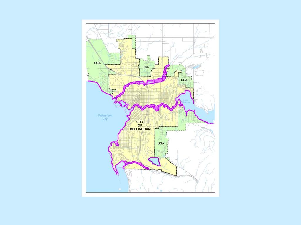
3 What areas are subject to the SMP? SHORELINES OF THE STATE which are: All areas waterward of the Ordinary High Water Mark (OHWM) and, All uplands within 200 feet of the Ordinary High Water Mark (OHWM) or the elevation of the Mean Higher High Tide (MHHT) and, up to the edge of 100-year floodplains and contiguous wetlands and, critical areas that are within or partly within these areas. Page 3 (A) and Page 77, section.180
4 Bellingham s Shorelines of the State: Bellingham Bay including Chuckanut Bay, Padden Lagoon and Padden Creek upstream to McKenzie Avenue. Whatcom, Squalicum and Chuckanut Creeks. Lakes Whatcom and Padden.
5
6 What is the SMP exactly? Local version of the SMA: (RCW 90.58) which requires local governments to: Page 6 (D)
7 Require water-dependent, water-related and waterenjoyment uses (a.k.a. water-oriented uses)

8 Protect shoreline natural resources
9 Promote public access

10 Manage Shorelines of Statewide Significance for the long-term benefit of all citizens of the State
11 SMP Guidelines Handbook for local governments intending to update their SMP s. State legislature directed DOE to update the 1972 version in Several iterations later the final SMP Guidelines were adopted in Guidelines translate SMA policies into standards for regulating uses on shorelines that result in a NO NET LOSS of ecological function.
12 The GMA requires the SMP to be consistent with and implement goals and policies in Bellingham s Comprehensive Plan (1995 and 2005) AND Provide a level of protection that is equal to or greater than level of protection of critical areas within shorelines. RCW 36.70A
13 What parts of the City of Bellingham Comprehensive Plan might interface with the SMP? The 1995 version and 2005 update include the following shoreline related sub-elements :

14 Neighborhood Plans Please See Appendix #3

15 Parks Open Space Plan

16 WFG Guiding Principles
17 .as well as Goals and Policies within the Framework, Land Use, Transportation, and Capital Facilities chapters...
18 ...For example: LUG-3 Bellingham continues to retain its natural, green setting by protecting unique natural features and public open spaces, creating greenbelts and preserving wooded hillsides in and around the city. New development is encouraged to incorporate existing mature vegetation and additional trees and native vegetation. Open space corridors along creeks include connections from the Bay to Whatcom and Padden lakes as well as along the Squalicum and Chuckanut Creek corridors heading to the mountains. In order to preserve or create these green corridors and open spaces, the community employs a variety of techniques, including incentives and regulations for the design and siting of new development, as well as public acquisition.

19 Bay City Supply

20 Another example: LUG-37 Land uses that promote and allow public access to the waterfront should be encouraged.
21 Other plans that will serve as a basis for identification of restoration planning and public access opportunities: (not an exhaustive list) Bellingham Bay Demonstration Pilot Project (BBPP) EIS and Comprehensive Strategy. BBPP Land Use and Habitat Documentation Reports. Bellingham Wildlife Habitat Assessment. Restoration Plan and Environment Assessment for Whatcom Creek (result of pipeline event).
22 How do the CAO and SMP relate to one another? The SMP must reference critical areas as specified in the CAO that are within jurisdiction of Shorelines of the State AND identify critical areas within MARINE shorelines. Please see page 77, Section.180) The SMP must provide an equal to or greater level of protection of critical areas specified within the CAO and for critical areas within MARINE shorelines. Please see page 9, L.

23 : ; : : NG CRA SS /..
24 Our task: Integrate all these elements and develop an SMP that achieves the following objectives:

25 Protection of ecological function

26 Requirements for public access

27 Designate preferred uses such as: WATER-DEPENDENT USES Please see section Shoreline Designations - D. High Intensity

28 WATER-RELATED USES Please see section Shoreline Designations - D. High Intensity

29 WATER-ENJOYMENT USES Please see section Shoreline Designations
30 AKA: WATER-ORIENTED USES

31 Shorelines for NON-WATER ORIENTED USES

32 AND... Identify restoration opportunities Please see APPENDIX #2
33 How do we get there?
34 Characterize shoreline resources Please see Shoreline Inventory - final report on web-page and page 23. Whatcom Creek Drainage Analysis Landscape Setting Land Use Landscape Setting Whatcom Creek is the only natural surface water outlet of Lake Whatcom. Whatcom Creek is 4.3 miles long with a drainage basin of approximately 5,790 acres. A control dam is located at the upper extent of Whatcom Creek, which is used for down-stream flood control, utility storage for water quantity and water quality considerations in the lake, and to maintain lake levels. The hydroperiod of Lake Whatcom is controlled for recreation and erosion control purposes. Lake levels are maintained at higher levels during the summer and lowered during the winter. This manipulation of water level and discharge affects the hydroperiod of Whatcom Creek. (Ref# 8,13,37,47,71 for above) Geology Upper reaches: Continental sedimentary rock, resulting in a narrow incised channel with steep slopes and bedrock substrate and outcrops. Lower reaches: Glaciomarine drift in narrow, incised channels that are surrounded by relatively flat terrain. (Ref# 21,103 for above) Soils Upper reaches: Moderate infiltration rates with moderate runoff potential. Lower reaches: Very slow infiltration, with high runoff potential. The mouth of Whatcom Creek is dominated by artificial fill. (Ref# 47,51,63 for above) Current Conditions Whatcom Creek flows through the heart of the City of Bellingham, and into Bellingham Bay in the middle of dense industrial development. Commercial, industrial, and residential uses dominate the land use in close proximity of the creek in the lower portion of Whatcom Creek. The Iowa Street corridor between Interstate-5 and Whatcom Falls Park is the only remaining length of the creek where there is development potential. Whatcom Falls Park located in the upper reaches of the SMA. (Ref# 8,16,33,34,71 for above)
35 Develop Shoreline Goals that address the following: Please see page 25, section.140, Shoreline Goals Shorelines uses Circulation Recreation Public Access Conservation Water Quality Historical, Cultural, educational, scientific Flood damage minimization Economic Development

36 Assign shoreline designations - for example: Please see page 33, section.150, Shoreline Designations
37 Develop general regulations For example: Development within shorelines designated NATURAL shall not be allowed within 200 of the OHWM.
38 And use specific regulations For Example: Docks, piers, floats and pilings within Lake Whatcom shall not be constructed with chemically treated wood. Please see page 68, section.170, Use Regulations, J.
39 Implement mitigation sequencing Avoid the impact Minimize the impact Rectify the impact by restoration Reduce the impact by preservation Compensate by replacing or enhancing Monitor impacts and make corrections Please see page 115, section.205, Mitigation Sequencing

40 Implement Restoration Planning Please see APPENDIX #2

41 Coordinate with other agencies including but not limited to:

42 These folks comprise our Technical Advisory Committee
43 This group s task is to: Review our shoreline inventory and ID data gaps. Provide assistance on determining jurisdiction and assigning designations. Review our goals and policies. Review our regulations to assure that they achieve a no net loss of ecological function. Assist in creating a framework for restoration planning.
44 Involve the general public Multiple public hearings and website info Review and comment on Shoreline Goals Review and comment on Shoreline Designations - uses Review and comment on Use Policies Identify restoration opportunities
45 NEXT STEPS: Planning Commission Public Hearing scheduled for December 15, 2005, 7 PM City Council Chambers Gather all comments and arrange by topic, present to Planning Commission, allow for further direction, recommendations.
Shoreline Master Program Town of La Conner, Washington
 Shoreline Master Program Town of La Conner, Washington Department of Ecology approval effective Adopted September 24, 2013 by Town of La Conner Ordinance No.1106 Amended May 13, 2014 by Town of La Conner
Public Visioning City of Kelso Planning Commission
 Shoreline Master Program Update Public Visioning City of Kelso Planning Commission November 13, 2012 Schedule Jurisdiction Inventory Analysis Visioning Topics Process Governing Principles Structure of
FAQ S about Restoration Planning FROM THE Department of Ecology WEBSITE:
 FAQ S about Restoration Planning FROM THE Department of Ecology WEBSITE: http://www.ecy.wa.gov/programs/sea/sma/st_guide/smp/restoration/qanda.html Notations in parentheses are staff notes directing you
Staff will be providing an overview of the project need, purpose and intent for consideration as part of the Amendment cycle.
 Agenda Item D-2 City of Tacoma Planning and Development Services To: Planning Commission From: Stephen Atkinson, Planning Services Division Subject: Open Space Corridors Project Meeting Date: March 1,
Stevens County Partnership Shoreline Master Program Update
 Stevens County Partnership Shoreline Master Program Update Public Open Houses 1 Overview Welcome and open house purpose Overview of Shoreline Management Act (SMA) Shoreline Master Program (SMP) update
Chapter 6. Overall Vision RECOMMENDATIONS. More Trail and Trail. Connections. Equal Access to Park. Facilities and Programs. Water Access.
 Overall Vision More Trail and Trail Connections Equal Access to Park Facilities and Programs Water Access Environment Variety Chapter 6 RECOMMENDATIONS Chapter 6 The following recommendations for park,
Chapter 14. Shorelines
 Chapter 14 Shorelines Contents City of Spokane Comprehensive Plan 14.1 INTRODUCTION... 7 14.2 SPOKANE S SHORELINE MASTER PROGRAM...11 14.3 ENVIRONMENTS AND MANAGEMENT POLICIES...15 14.5 GOALS AND POLICIES...22
City Center Neighborhood Plan
 [1] City Center Neighborhood Plan As adopted by Ordinance No. 2014-09-049 and amended by Ordinance Nos. Formerly CBD Neighborhood as adopted by Ordinance No. 8868 and amended by Ordinance Nos. 8946, 9693,
Existing Facilities. Chapter 3:
 Leave all the afternoon for exercise and recreation, which are as necessary as reading, I will rather say more necessary because health is worth more than learning. - Thomas Jefferson Chapter 3: Existing
E X I S T I N G F A C I L I T I E S
 E X I S T I N G F A C I L I T I E S An extensive network of park, recreation and open space facilities is provided by the City and other agencies including County, School District, Port and State and is
City of Richland Comprehensive Plan: Integrated Non-project Final Environmental Impact Statement
 City of Richland Comprehensive Plan: Integrated Non-project Final Environmental Impact Statement September 12, 2017 Prepared for: City of Richland Prepared by: Oneza & Associates With assistance from:
Clallam County Shoreline Master Program Update. Salt Creek and Tongue Point, 2006
 Clallam County Shoreline Master Program Update Salt Creek and Tongue Point, 2006 Presentation to the Sequim Association of Realtors 23 February 2011 Why Shoreline Master Program? Accommodate future development
Chapter 5: Natural Resources and Environment
 NATURAL RESOURCES AND ENVIRONMENT 5-1 5 Chapter 5: Natural Resources and Environment BACKGROUND AND INTENT Urban expansion represents the greatest risk for the future degradation of existing natural areas,
City of Tacoma Shoreline Master Program Update Stakeholder Advisory Committee Meeting September 10, 2009
 City of Tacoma Shoreline Master Program Update Stakeholder Advisory Committee Meeting September 10, 2009 Agenda Overview Progress to Date Upcoming Schedule Structure of the SMP Shoreline Environment Designations
Working Group Meeting
 April 4,, 2017 Parks Operations Bldg Working Group Meeting Arts Districts Overview Stormwater/RPA/Stream Considerations First Principles Agenda 7:00pm 7:05pm 7:10pm 7:40pm 8:30pm 9:40pm 9:45pm Welcome
SHORELINE MASTER PROGRAM
 SHORELINE MASTER PROGRAM 2013 CITY OF PORT ORCHARD CITY OF PORT ORCHARD MARCH 2013 REVISED FEBRUARY 2018 Page 2 City of Port Orchard Shoreline Master Program March 2013 Rev. Feb 2018 ACKNOWLEDGEMENTS MAYOR
Irongate Neighborhood Plan
 Plan As adopted by Ordinance No. 2010-12-068 and amended by Ordinance 2015-11-044 Mt. Baker Neighborhood - As adopted by Ordinance No. 8868 and amended by Ordinances 8946, 8995, 9174, 9271, 9601, 9697,
Advice from Department of Ecology
 Advice from Department of Ecology The simplest way to reduce landslide risk is to avoid slideprone areas in the first place. Simple practices such as building a house farther from the edge of a steep slope,
Joe Pool Lake Lake Master Plan Public Information Meeting Presentation of Final Draft Revision July 31, 2018
 Joe Pool Lake Lake Master Plan Public Information Meeting Presentation of Final Draft Revision July 31, 2018 Presented By Jeremy Spencer Lake Manager U.S. Army Corps of Engineers Fort Worth District US
EXHIBIT A CITY OF FORT WALTON BEACH, FLORIDA COASTAL MANAGEMENT & CONSERVATION
 EXHIBIT A CITY OF FORT WALTON BEACH, FLORIDA INTRODUCTION The Coastal Management and the Conservation Elements required by Chapter 9J-5.012 and 5.013, F.A.C., respectively, have been combined into one
When planning stormwater management facilities, the following principles shall be applied where possible.
 2.0 Principles When planning stormwater management facilities, the following principles shall be applied where possible. 2.0.1 Drainage is a regional phenomenon that does not respect the boundaries between
Introduction. Chapter 2 Land Use
 Chapter Two Land Use Introduction The fundamental precepts of the Whatcom County Comprehensive Plan are to comply with the Growth Management Act (GMA), adhere to the Countywide Planning Policies and implement
St. Croix County Shoreland Overlay Zoning Districts. Public Hearing Community Development Committee December 19, 2013
 St. Croix County Shoreland Overlay Zoning Districts Public Hearing Community Development Committee December 19, 2013 Timeline CDC Review October 17 Public Information Meeting October 29 (6:00-8:00 pm)
CHAPTER ONE INTRODUCTION
 1.0 Introduction Bellingham s central waterfront is in a state of transition from its long history as an active industrial site to a new mixed-use neighborhood. Over the past several years, the Port of
Memorandum Planning. Thursday, January 8, 2015
 Memorandum Planning Thursday, January 8, 2015 7.A. To: Coastal Advisory Committee From John Ciampa, Associate Planner Subject: Review Draft Local Coastal Program Copies: James Pechous, City Planner Purpose
Chapter WAC SHORELINE MASTER PROGRAM GUIDELINES. Table of Contents WAC AUTHORITY, PURPOSE AND EFFECTS OF GUIDELINES.
 Chapter 173-26 WAC SHORELINE MASTER PROGRAM GUIDELINES Table of Contents WAC 173-26-171 AUTHORITY, PURPOSE AND EFFECTS OF GUIDELINES. 5 WAC 173-26-176 GENERAL POLICY GOALS OF THE ACT AND GUIDELINES FOR
Washington State Growth Management Act: The Basics. Kitsap County Department of Community Development
 Washington State Growth Management Act: The Basics Kitsap County Department of Community Development Purpose/History Enacted in 1990 Amended virtually every year since Manage Growth Concentrating population
7.0 SOCIAL, ECONOMIC, AND ENVIRONMENTAL ISSUES
 7.0 SOCIAL, ECONOMIC, AND ENVIRONMENTAL ISSUES The following list of social, economic, and environmental issues have been identified based on a preliminary inventory of resources in the project area, an
RECREATION, OPEN SPACE AND GREENWAYS ELEMENT GOALS, OBJECTIVES, AND POLICIES
 RECREATION, OPEN SPACE AND GREENWAYS ELEMENT GOALS, OBJECTIVES, AND POLICIES GOAL R-1: DEVELOP A RECREATION, OPEN SPACE AND GREENWAYS SYSTEM AS AN INTEGRAL COMPONENT OF AN OVERALL, COUNTY-WIDE ECONOMIC
2011 ASLA Design Awards. Westside Creeks Restoration Plan Merit Award AECOM, Fort Collins. Planning & Urban Design
 2011 ASLA Design Awards Westside Creeks Restoration Plan Merit Award AECOM, Fort Collins Planning & Urban Design Project Fact Sheet Category of Entry: Rotating Specialty Award: 2011 2011 ASLA Colorado
Stormwater Regulations & Considerations Morse Study Area. Pam Fortun, P.E. CFM Senior Stormwater Treatment Engineer Engineering Services Division
 Stormwater Regulations & Considerations Morse Study Area Pam Fortun, P.E. CFM Senior Stormwater Treatment Engineer Engineering Services Division Stormwater Regulations Development Considerations Floodplain
Exhibit A Comprehensive Plan Amendments
 Exhibit A Comprehensive Plan Amendments May 2010 Draft Chapter One - Introduction Chapter One INTRODUCTION NOTE: For brevity and ease in viewing the proposed changes, portions of chapter one that are not
RECREATION AND OPEN SPACE ELEMENT GOALS, OBJECTIVES, AND POLICIES
 RECREATION AND OPEN SPACE ELEMENT GOALS, OBJECTIVES, AND POLICIES Goal 7 To provide park facilities, recreation programs, and open space resources that are safe, adequate, and accessible to all City residents,
CITY OF BELLINGHAM PLANNING DEPARTMENT STAFF REPORT
 1 1 1 1 1 1 1 1 0 1 0 1 0 1 0 CITY OF BELLINGHAM PLANNING DEPARTMENT STAFF REPORT Agenda Topic: For: Staff Contact: I. Project Summary Review of the Waterfront District subarea plan and associated documents,
Draft Rhode Island Stormwater Design and Installation Standards Manual
 Draft Rhode Island Stormwater Design and Installation Standards Manual Summary The May 2009 Public Review Draft version of the RI Stormwater Design and Installation Standards Manual consists of approximately
Ridgefield and the Growth Management Act
 1 2 Ridgefield and the Growth Management Act 3 Why Do We Plan History of Planning in Ridgefield Washington experiences rapid growth in the late 1980 s that began to change the perceived quality of life.
Level 1 Downstream Analysis
 Level 1 Downstream Analysis Newcastle Way Apartments Newcastle, Washington King County April 14, 2014 Revised July 10, 2014 Prepared by: Dean A. Furr, P.E. Reviewed by: Donald Scarberry, P.E. Coffman Engineering,
SAN RAFAEL GENERAL PLAN 2040 INTRODUCTION AND OVERVIEW
 SAN RAFAEL GENERAL PLAN 2040 INTRODUCTION AND OVERVIEW Steering Committee Presentation February 14, 2018 Purpose of General Plan Guide land use and development decisions Coordinate transportation, infrastructure,
Cornwall Park Neighborhood Plan
 [1] Cornwall Park Neighborhood Plan As adopted by Ordinance No. 8868 and amended by Ordinance Nos. 8946, 9200, 9201, 9233, 9301, 9305, 9749, 9787, 9764, 10502 and 10738, 2000-12-094, 2004-12-087, 2004-12-091,
This page intentionally blank.
 This page intentionally blank. Parks, Recreation, and Open Space Chapter Relationship to Vision Vision Parks, Recreation and Open Space Chapter Concepts County Government. County government that is accountable
DISCUSSION TOPIC: ST JOHNS RIVER & ITS TRIBUTARIES (BPII) 2030 COMPREHENSIVE PLAN POLICES AND REGULATORY FRAMEWORK
 2030 COMPREHENSIVE PLAN POLICES AND REGULATORY FRAMEWORK") DISCUSSION TOPIC: ST JOHNS RIVER & ITS TRIBUTARIES (BPII) 2030 COMPREHENSIVE PLAN POLICES AND REGULATORY FRAMEWORK St. John s River & Its Tributaries Issue Summary: The St. Johns River is an important
DISCUSSION TOPIC: ST JOHNS RIVER & ITS TRIBUTARIES (BPII) 2030 COMPREHENSIVE PLAN POLICES AND REGULATORY FRAMEWORK St. John s River & Its Tributaries Issue Summary: The St. Johns River is an important
TO: Port of Orcas FROM: Tina Whitman, Science Director SUBJECT: Master Plan Update DATE: September 7, 2018
 TO: Port of Orcas FROM: Tina Whitman, Science Director SUBJECT: Master Plan Update DATE: September 7, 2018 Friends of the San Juans appreciates the opportunity to provide input to the Port of Orcas Master
Zoning Ordinance Chapter 10
 CHAPTER 10 - WASHES SECTION 10.0 GENERAL: A. The purpose of this Ordinance is to establish standards for development in or near Major and Minor Washes as defined in Appendix A Glossary of Terms and Definitions
Planning for Staten. Habitat Restoration and Green Infrastructure. Island s North Shore
 Habitat Restoration and Green Infrastructure Planning for Staten Island s North Shore Community Board 1 March 1, 2018 NYC Parks Forestry, Horticulture, and Natural Resources Funded by the NYS Department
Mendota Heights 2040 Comprehensive Plan Draft Vers
 4 Parks and Trails The City of Mendota Heights boasts a variety of recreational and open space opportunities. Few cities can claim access to regional trails, riverside and lakeside parks, scenic bluffs
MUCKLESHOOT INDIAN TRIBE Fisheries Division nd Avenue SE. Auburn, Washington
 MUCKLESHOOT INDIAN TRIBE Fisheries Division 39015-172nd Avenue SE. Auburn, Washington 98092-9763 Phone: (253) 939-3311. Fax: (253) 931-0752 Mr. David Radabaugh Shoreline Planer W A Dept. of Ecology 3190
City of Tacoma Planning and Development Services
 Agenda Item D-1 City of Tacoma Planning and Development Services To: Planning Commission From: Elliott Barnett, Planning Services Division Subject: Application #2014-08 Open Space Element Update Meeting
Draft Stillwater 2030 Comprehensive Plan- Goals and Policies
 Draft Stillwater 2030 Comprehensive Plan- Goals and Policies Instructions- Review each goal and policy and discuss with group any changes, deletions for additions to the list using your groups pen. Keep
INTRODUCTION PLANNING HISTORY
 INTRODUCTION The Upper Rock Creek Master Plan Area lies in the east central part of Montgomery County. The Master Plan Area is adjacent to the City of Rockville to the south, the Olney Planning Area to
Riparian Buffer on the Bushkill Creek. Policies
 Riparian Buffer on the Bushkill Creek Riparian buffers provide numerous benefits to landowners and the community by protecting groundwater recharge areas, providing flood control, providing stormwater
Existing Conditions and Environmental Consequences Floodplains
 3.9 Environmental Consequences 3.8 3.8.1 WHAT ARE FLOODPLAINS? are low-lying areas adjacent to rivers, streams, and other waterbodies that are susceptible to inundation (flooding) during rain events. These
The City shall enhance and improve the accessibility of parks and recreational facilities while protecting their quality. by:
 GOALS, OBJECTIVES AND POLICIES GOAL 1: To provide open space and recreation as an essential element needed for the betterment of the City s character and quality of urban life. The City shall plan for
Pinellas County Greenways
 Pinellas County Greenways USING GREENWAYS TO LINK OPEN SPACES The Florida Greenways Commission has defined a greenway as...a corridor of protected open space that is managed for conservation and/or recreation.
City of Lafayette Study Session Staff Report Design Review Commission
 ++ City of Lafayette Study Session Staff Report Design Review Commission Meeting Date: January 08, 2018 Staff: Subject: Chris Juram, Planning Technician SS12-17 Miramar Homebuilders, R-20 Zoning: Request
Watershed Planning Workshop
 Watershed Planning Workshop Upper Four Mile Run, Gulf Branch and Donaldson Run March 18, 2010 Langston Brown Community Center Outline Overview of Arlington s s Watersheds Watershed Management in Arlington
Waterfront Redevelopment. City Council Briefing May 15, 2006
 Waterfront Redevelopment City Council Briefing May 15, 2006 Topics Reason for this presentation Recap of recent waterfront events Marina/Park economic and feasibility evaluation Planned next steps Recap
Planning Commission Retreat March 23 rd Comprehensive Plan Update Discussion
 Planning Commission Retreat March 23 rd 2011 Comprehensive Plan Update Discussion Purpose of This Discussion Go Over Key Aspects of the Update Discuss Element By Element Key Concepts Big Ideas What Policies
Chapter 10 IMPLEMENTATION RECOMMENDATIONS
 Chapter 10 IMPLEMENTATION RECOMMENDATIONS The recommended land use plan presented in the previous chapter provides a design for the attainment of the urban and rural development and open space preservation
Urban Fringe Subarea Plan
 Urban Fringe Subarea Plan Updated February 27, 2018 Table of Contents Page I. Existing Goals and Policy Framework 2 A. Growth Management Act (GMA) B. County-wide Planning Policies C. Whatcom County Comprehensive
17.18 SENSITIVE AREAS
 17.18 SENSITIVE AREAS 17.18.010 Purpose...1 17.18.020 Definitions...1 17.18.030 Review Process...1 17.18.040 Sensitive Areas Analysis...2 17.18.050 Standards and Development Plan...3 17.18.060 Geotechnical
TERRESTRIAL NATURAL HERITAGE SYSTEM STRATEGY APPENDIX F: MODEL POLICIES FOR THE IMPLEMENTATION OF THE TARGET TERRESTRIAL NATURAL HERITAGE SYSTEM
 TERRESTRIAL NATURAL HERITAGE SYSTEM STRATEGY APPENDIX F: MODEL POLICIES FOR THE IMPLEMENTATION OF THE TARGET TERRESTRIAL NATURAL HERITAGE SYSTEM C H A P T E R 1 M O D E L P O L I C I E S F O R I M P L
WASHINGTON COUNTY OREGON
 WASHINGTON COUNTY OREGON LONG RANGE PLANNING DIVISION North Bethany Subarea Stream Corridors: Existing Regulations In Oregon, there is a distinct difference between the land use rules that apply in rural
The following principles guide the development of goals and strategies to protect and promote these amenities:
 OPEN SPACE/PARKS/TRAILS/RECREATION GOALS/STRATEGIES Cherry Hills Village is a living environment that offers low density development, open areas, public scenic vistas, public trails and public parks. This
HAZARD MITIGATION GOALS AND OBJECTIVES
 SEWRPC Community Assistance Planning Report No. 282, 2nd Edition CITY OF MILWAUKEE ALL HAZARDS MITIGATION PLAN UPDATE Chapter IV HAZARD MITIGATION GOALS AND OBJECTIVES [NOTE: Throughout this plan update
A larger version of this map is located on the last page of this PDF.
 MAP Committee Input McLoughlin Area Draft Vision Map A larger version of this map is located on the last page of this PDF. 1. The map above is intended to portray a vision for the McLoughlin area. It highlights
Parks, Trails, and Open space Element
 Parks, Trails, and Open space Element Parks, Trails, and Open Space element Parks, Recreation, and Open Space are important components of the quality of life desired by the residents of Elk Grove. This
PUBLIC MEETING SEPTEMBER 19, 2012
 PUBLIC MEETING SEPTEMBER 19, 2012 M-NCPPC Project Manager Marian Elsasser Project Engineer Kim Paniati PROJECT TEAM Consultants Greenman-Pedersen, Inc. (GPI) Project Manager Liz Marcy Environmental Specialist
Woodland Conservation and the Master Plan
 1 WHAT IS A MASTER PLAN? A Vision for the Future of Your Community Woodland Conservation and the Master Plan Goals Objectives Strategies 2 How Will Your Community Look? TREE PRESERVATION AND THE MASTER
ST. MARY S SOIL CONSERVATION DISTRICT (SMSCD) AND DPW&T CONCEPT EROSION AND SEDIMENT CONTROL AND STORMWATER MANAGEMENT GUIDELINES AND CHECKLIST
 AND DPW&T CONCEPT EROSION AND SEDIMENT CONTROL AND STORMWATER MANAGEMENT GUIDELINES AND CHECKLIST") St. Mary s Soil Conservation District 26737 Radio Station Way, Suite B Leonardtown, MD 20650 Phone: 301-475-8402 ext. 3 Fax: 301-475-8391 www.stmarysscd.com St. Mary s County Government Department of Public
St. Mary s Soil Conservation District 26737 Radio Station Way, Suite B Leonardtown, MD 20650 Phone: 301-475-8402 ext. 3 Fax: 301-475-8391 www.stmarysscd.com St. Mary s County Government Department of Public
Auke Bay Area Plan. Complete List of Goals and Policies for the Auke Bay Area Plan
 Auke Bay Area Plan Complete List of Goals and for the Auke Bay Area Plan Recreation Goals & Pedestrian Access Goal 1: Link the Auke Bay area with an accessible system for recreation and transportation.
Parks, Trails, and Open Space Element
 P arks, Recreation, and Open Space are important components of the quality of life desired by the residents of Elk Grove. This Element of the General Plan addresses the City s goals, policies, and actions
Rule D Wetland and Creek Buffers
 Rule D Wetland and Creek Buffers 1 Policy It is the policy of the Board of Managers to ensure the preservation of the natural resources, recreational, habitat, water treatment and water storage functions
6Natural. Environment Development Permit Guidelines
 6Natural Bylaw 2600-2016, being "Official Community Plan Bylaw, 2016" Schedule "A" CITY OF ABBOTSFORD OFFICIAL COMMUNITY PLAN Environment Development Permit Guidelines Part V - 6-1 Area Subdivision or
Key Elements of Successful Conservation Planning. John Paskus October 17, 2013 Pierce Cedar Creek Institute Michigan Natural Features Inventory
 Key Elements of Successful Conservation Planning John Paskus October 17, 2013 Pierce Cedar Creek Institute Michigan Natural Features Inventory What is Conservation Planning? Pressey et al (2008): The process
ELIGIBILITY CRITERIA CHECKLIST OPEN SPACE CLASSIFICATION
 THURSTON COUNTY DEVELOPMENT SERVICES OPEN SPACE TAX PROGRAM ELIGIBILITY CRITERIA CHECKLIST OPEN SPACE CLASSIFICATION Use this checklist to help you determine whether your property is eligible for open
APPENDIX C. Architectural and Environmental Design Standards. Environmentally sensitive areas should be protected.
 APPENDIX C Architectural and Environmental Design Standards Environmentally Sensitive Areas Goal A. Environmentally sensitive areas should be protected. Development, such as roads, houses, and other structures,
Manchester. Vision for Manchester
 Manchester Vision for Manchester The Manchester Community Plan is a statement of the community values and aspirations for the future. This is an effort to recognize what originally attracted visitors in
DRAFT MAP AMENDMENT FLU 04-4
 DRAFT MAP AMENDMENT FLU 04-4 SW 24 TH AVENUE ROADWAY CORRIDOR The University of Florida participates with the Metropolitan Transportation Planning Organization (MTPO) in its responsibilities for the continuing,
3. VISION AND GOALS. Vision Statement. Goals, Objectives and Policies
 Vision Statement Queen Creek s interconnected network of parks, trails, open spaces and recreation opportunities provide safe and diverse activities and programs that sustain its unique, small town, equestrian
Community LID Workgroup Issue Paper #6
 Community LID Workgroup Issue Paper #6 Topic: Hard and Impervious Surface Coverage Limits Objective: Minimize the amount of hard and impervious surfaces in developments to allow more stormwater to infiltrate
Options for addressing City of Edmonds Alternatives to Ecology s Required Changes addressing Edmonds Marsh Buffers and Setbacks.
 Options for addressing City of Edmonds Alternatives to Ecology s Required Changes addressing Edmonds Marsh Buffers and Setbacks. This document presents Ecology s response to the City of Edmonds alternatives
Dwelling Units Max 12 dwelling units per acre/min 8 dwelling units per acre. Development Mix 80% non residential/20% residential
 13. OSTEEN LOCAL PLAN Background: The Osteen Local Plan area is located in southwest Volusia County along the SR 415 corridor between Lemon Bluff Road and Acorn Lake Road and includes 3,990 acres. The
LAND USE ELEMENT. Purpose. General Goals & Policies
 LAND USE ELEMENT Purpose This Land Use Element contains the goals and policies necessary to support the City s responsibility for managing land resources and guiding development through implementing regulations,
Welcome. Tannery and Waterworks Parks Shoreline Improvements Environmental Assessment. Public Information Centre #1 November 27, pm to 8 pm
 Welcome Tannery and Waterworks Parks Shoreline Improvements, Environmental Assessment Tannery and Waterworks Parks Shoreline Improvements Environmental Assessment #1 6 pm to 8 pm Why We Are Here Tannery
NJ Department of Environmental Protection
 NJ Department of Environmental Protection COASTAL AND LAND USE PLANNING New Jersey Coastal Management Program Covers NJ coastal waters to limit of tidal influence including 239 municipalities in 19 counties,
CONSERVATION ELEMENT GOALS, OBJECTIVES, AND POLICIES
 CONSERVATION ELEMENT GOALS, OBJECTIVES, AND POLICIES Goal 4 To conserve, manage, appropriately use and protect the natural resources of the City ensuring continued resource availability and environmental
Rural Land Use Designations Kittitas County December 6, 2007 Draft
 KITTITAS COUNTY COMMUNITY DEVELOPMENT SERVICES 411 N. Ruby St., Suite 2, Ellensburg, WA 98926 CDS@CO.KITTITAS.WA.US Office (509) 962-7506 Fax (509) 962-7682 Rural Land Use Designations Kittitas County
SENSITIVE LANDS OVERLAY
 SENSITIVE LANDS OVERLAY Chapter 22 Sensitive Lands Overlay 22.1 PURPOSE 22.2 APPLICATION AND ANALYSIS REQUIREMENTS 22.3 SENSITIVE LAND REGULATIONS 22.4 ADMINISTRATIVE PROVISIONS 22.5 DESIGN STANDARDS 22.6
I. STAFF POLICY RECOMMENDATIONS. The following RMP policy strategies are proposed by staff in support of a Scenic Resource Protection Program:
 Policy Consideration: Scenic Resource Protection Program Status: For Consideration by the Highlands Council at September 14, 2006 Work session Date: September 12, 2006 I. STAFF POLICY RECOMMENDATIONS The
4.1 LAND USE AND HOUSING
 4.1 This section provides a project-level analysis of potential impacts to land use, Shorelines of the State (shorelines), and housing. The study area for the land use and housing analysis in the Final
City of Surrey Ecosystem Management Study. Integration of ecological processes with land use
 City of Surrey Ecosystem Management Study Integration of ecological processes with land use Natural areas in Surrey are changing as the City grows and evolves. Many important natural areas remain or may
CONSERVATION ELEMENT:
 CONSERVATION ELEMENT: Goals, Objectives and Policies Goal 1: To conserve, protect and enhance the functions and values of the natural resources within Jupiter to ensure the highest environmental quality
Richton Park Western Development Corridor Green Infrastructure Development Plan August 18, 2017
 Richton Park Western Development Corridor Green Infrastructure Development Plan August 18, 2017 Conservation Design Forum Geosyntec Consultants 403 W. St. Charles Road 1420 Kensington Road, Suite 103 Lombard,
Minnesota Department of Natural Resource - Natural Resource Guidance Checklist Conserving Natural Resources through Density Bonuses
 Minnesota Department of Natural Resource - Natural Resource Guidance Checklist Conserving Natural Resources through Density Bonuses NRDB Why Use Density Bonuses & This Checklist Local units of government
Section 3 Non-Structural BMPs
 3.1 Stream Buffers A stream buffer or stream setback is a designated area around a stream, lake, or wetland left in a natural, densely vegetated state so as to protect the receiving water quality and provide
1. Parks & Recreation Neighborhood Parks Community Parks Special Use Sites 2. Open Space 3. Trails
 Appendix A: Park Classifications The intent of parks and recreation classifications is to aid in making acquisition and design decisions for park sites, facilities and the organization of recreation space
CHAPTER Committee Substitute for Senate Bill No. 1472
 CHAPTER 2007-99 Committee Substitute for Senate Bill No. 1472 An act relating to beaches and shores; amending s. 161.021, F.S.; amending a definition; amending s. 161.085, F.S.; restricting the use of
Florida Forever Conservation Needs Assessment Overview Maps
 Florida Forever Conservation Needs Assessment Overview Maps Prepared by Florida Natural Areas Inventory, The maps in this document are derived from the Florida Forever Conservation Needs Assessment, an
APPENDIX I Presentations
 APPENDIX I Presentations Workshop Summary Report 11 Peel Region Official Plan Review May 5, 2010 Compatible Active Recreation Workshop July 29, 2010 Components of PROPR Sustainability Planning Tools/Updates
Nick Sigmund, Sr. Zoning Officer
 Nick Sigmund, Sr. Zoning Officer Wisconsin Department of Natural Resources Administrative Code NR 115 under the authority of Wisconsin Statute 59.692, establishes and provides that shoreland zoning regulations