CITY OF TARPON SPRINGS DCA#11-1AR
|
|
|
- Valentine Atkinson
- 5 years ago
- Views:
Transcription
1 Agenda Item #3.H.2 05/09/11 TAMPA BAY REGIONAL PLANNING COUNCIL LOCAL GOVERNMENT COMPREHENSIVE PLAN ADOPTED AMENDMENT REPORT CITY OF TARPON SPRINGS DCA#11-1AR 1
2 ADOPTED WITH THE FOLLOWING CHANGES: Ordinance was amended to include Section 5. ADOPTION BY REFERENCE INTO THE COMPREHENSIVE PLAN. This section addresses the advisory comment provided by DCA. Page 3-38; The Transitional Review Process, under Section I, LOCAL ADOPTION PROCESS, has been removed (no longer applicable, since a regulating/zoning plan has been adopted concurrently with Ordinance ). The notation February 2011 First Edition has been added to cover and inside cover (DCA Advisory comment). Table 4-2; Title was corrected to reflect Proposed Future Land Use Development Standards. The following changes were required by the Pinellas County Countywide Planning Authority o Impervious Surface Ratios (ISR) were added to all Character Districts (Tables 3-1 through 3-10). o Bed & Breakfast uses shall be subject to a density restriction of 3.0 units per base residential district density. o Within the Spring Bayou District (Table 3-7), Inns shall be limited to 30 units per acre and an FAR of.50; hotels shall be subject to 30 units per acre and.75 FAR. 2
3 Amendment # Community Redevelopment District with Special Area Plan FLUM Amendment 1. Local Government Name: Tarpon Springs 2. Amendment Number: 10-1AR 3. Is the RPC precluded from commenting on the proposed plan or element pursuant to s (5). F.S., or Rule 9J , L.O.F.; or commenting on the proposed amendment pursuant to s (4)(b), F.S.? (YES) (NO) 4. Date DCA Notified RPC that Amendment Package was Complete, if Applicable: 5. Date Amendment Review must be Completed and Transmitted to DCA: 11/21/10 6. Date the Amendment Review was transmitted to DCA: 7. Description of the Amendment: From: Residential Urban, Residential Medium, Residential Office General, Commercial Neighborhood, Commercial Limited, Commercial General, Commercial General Fishing, Industrial Limited, Industrial General, Preservation, and Water To: Size: Community Redevelopment District (CRD) 248 acres Location: City of Tarpon Springs Existing Use: Community Redevelopment Area & Sponge Docks Proposed Use: Community Redevelopment District The FLUM amendment contains approximately 248 acres and will designate the area as CRD, Community Redevelopment District, with a Special Area Plan. The area encompasses the City s Community Redevelopment Area and the tourist area known as the Sponge Docks. The proposed amendment is intended to promote mixed use development and a livable, walkable community in accordance with the adopted Goal 4 of the City s Future Land Use Element. THE STUDY AREA The study area comprises the core urbanized heart of Tarpon Springs. It includes approx. 248 acres of an elongated area roughly between Meres Boulevard at the south end and the Anclote River at the north end. It is comprised mostly of the City s CRA. Other overlapping local 3
4 jurisdictions include the Tarpon Springs National Register Historic District and the City s Multi- Modal Transportation District (MMTD). SPECIAL AREA PLANCTION The Special Area Plan (SAP) provides the basis for amending the Countywide Plan Map to allow mixed use development in the planning area consistent with specific standards, guidelines, and policies which address the following: mix, location, densities, and intensities of permitted uses; form, character and design of development; transportation and mobility; infrastructure impacts; the plan s relationship to existing local and regional plans and policies; and other factors addressed under Section of the Countywide Plan Rules. Subsequent to the adoption of the SAP, the City will prepare and adopt form-based regulations applicable to the planning area and consistent with the approved Special Area Plan. The regulations will address the correlation between Character District, street and building (use) type. The primary objective of the regulations will be to provide new development and redevelopment projects with a framework for implementing the mixed use, pedestrian oriented neighborhoods envisioned through the Character Districts. The area subject to this Special Area Plan (SAP) has been divided into ten Character Districts. The Character Districts are like neighborhoods with generally similar use and functional characteristics and distinct edges that form the limits of the districts. The number of districts and their respective locations were derived over a number of Planning & Redevelopment Focus Group (PRFG) public meetings and communitywide workshops. Character District designations and configurations are also considerate of the generally agreed upon future land uses, function and development character planned for each district. The Character Districts will carry forward into the form-based land development regulations that will be drafted for the area following adoption of the Special Area Plan. The purpose of the Community Redevelopment District (CRD) category is to depict areas that are now designated, or appropriate to be designated, as community centers and neighborhoods for redevelopment. Typical uses include residential, office, commercial, industrial, institutional and transportation/utility facilities. The category is intended to encourage development and redevelopment with a combination of these uses in areas designed to serve as local retail, financial, governmental, residential, and employment focal points for a community. This category is also intended to support infill and redevelopment in a way that is compatible with the existing character and to promote diverse and vibrant built environments. The CRD category is implemented by a special area plan. 4
5 The proposed CRD including the ten Character Districts covers approximately 201 acres (not including public rights-of-way). The special area plan specifies development standards (Residential Density, Building FAR, Non-Residential FAR, and Recommended Building Heights) and building uses. The standards will be defined in greater detail in the land development regulations based on specific street types and location within a character district following the adoption of the Special Area Plan. Therefore, the standards set forward in the SAP are absolute maximums and, thus, specific project uses, densities, intensities and building heights ultimately approved will be subject to and limited by the land development regulations. The Character Districts are as follows: Sponge Docks The Sponge Docks character district is primarily comprised of tourist-oriented commercial business, restaurants and industrial waterfront uses. The character district will continue to support the working waterfront and tourist trade while increasing the number of actual residents to the area in order to improve overall neighborhood stability and support local businesses. Density (Base/Max.) in dus/acre 14 / 22 FAR (Max.) 1.0 Non-Residential FAR (Max.) 0.65 Municipal Gateway The Municipal Gateway character district is mostly city owned property and located adjacent to some ecologically sensitive areas on the Anclote River. This character district is suited to mostly civic uses and possibly an eco-friendly hotel or inn. Density (Base/Max.) in dus/acre 4 / 4 FAR (Max.) 1.0 Non-Residential FAR (Max.) 0.75 Uptown The Uptown character district is a predominantly residential district with medium density and mixed use residential development. Density (Base/Max.) in dus/acre 12 / 16 FAR (Max.) 1.0 Non-Residential FAR (Max.) 0.65 North Pinellas The North Pinellas Avenue character district is focused on the North Pinellas Ave. retail corridor extending from Live Oak to Center Street. The general focus of this district will continue to be retail with some medium density and mixed use residential development. Density (Base/Max.) in dus/acre 14 / 18 FAR (Max.) 1.0 Non-Residential FAR (Max.)
6 Downtown The Downtown character district is focused on Tarpon Ave. which is the main street for the CRA. The suggested uses for this district are intended to promote retail development and encourage medium density and mixed use residential development to support the retail along Tarpon Ave. Density (Base/Max.) in dus/acre 15 / 22 FAR (Max.) 1.25 Non-Residential FAR (Max.) 1.0 Downtown Gateway The Downtown Gateway character district is focused on Tarpon Ave. which is the main street for the CRA. The suggested uses for this district are intended to promote mixed use residential development to support the retail along Tarpon Ave. Density (Base/Max.) in dus/acre 14 / 20 FAR (Max.) 1.0 Non-Residential FAR (Max.) 0.5 Spring Bayou The Spring Bayou character district is a predominantly residential district located near Spring Bayou. The waterfront location is suited to a residential scaled bed & breakfast or inn in this district along with some medium density residential building types and commercial mixed use and residential mixed use. Density (Base/Max.) in dus/acre 12 / 18 FAR (Max.) 0.75 Non-Residential FAR (Max.) 0.5 South Pinellas The South Pinellas Avenue character district is focused on the South Pinellas Ave. retail corridor extending from Boyer to Morgan St. The primary intent of this character district is to encourage mixed use along the corridor with ground floor retail and residential or offices on upper floors. Density (Base/Max.) in dus/acre 18 / 24 FAR (Max.) 1.25 Non-Residential FAR (Max.) 1.0 South Gateway The South Gateway character district consists of some large acreage redevelopment sites. The intent of the character district development standards is to encourage mixed use development with ground floor retail and residential or offices on upper floors. Density (Base/Max.) in dus/acre 18 / 24 FAR (Max.) 1.5 Non-Residential FAR (Max.) 1.0 6
7 South Safford The South Safford character district is limited to the parcels located along the eastside of South Safford Ave. between Boyer and Meres Blvd. This district is mostly residential with some light industrial and neighborhood retail. The intent of the character district development standards is to encourage residential development with limited neighborhood retail development. Density (Base/Max.) in dus/acre 10 /12 FAR (Max.) 0.75 Non-Residential FAR (Max.) Is the Amendment consistent with the Strategic Regional Policy Plan? Consistent with SRPP. 9. Applicable Strategic Regional Policy Plan Goals and Objectives: Economic Development: Policy 2.9; Transportation: Goal 5B, Policies 5.19, 5.20, 5.23, 5.28, 5.35, 5.37, 5.41, The effects on the Proposed Amendment on Regional Resources or Facilities Identified in the Strategic Regional Policy Plan: Not applicable to the amendment. 11. Extra-Jurisdictional Impacts that would be Inconsistent with the Comprehensive Plan of the Affected Local Government: Not applicable to the amendment. Analysis of the effects of the proposed amendments on the following issues to the extent they are addressed in the Strategic Regional Policy Plan on: 12. Compatibility among local plans including, but not limited to, land use and compatibility with military bases: The amendment is compatible with local plans. 13. Impacts to significant regional resources and facilities identified in the Strategic Regional Policy Plan, including, but not limited to, impacts on groundwater recharge and the availability of water supply: The City s upcoming reverse osmosis water treatment facility is expected to meet the City s average and peak capacity drinking water needs for more than 20 years without a facility expansion and will render the City water supply independent, and the current projected need for water by the year 2025 is 3.7 mgd. Adequate system capacity appears to be available to meet the potential increased demand for potable water. All other public facilities will be able to meet demand. 7
8 14. Affordable housing issues and designation of adequate sites for affordable housing: The Special Area Plan does not address affordable housing provisions. Affordable housing is not as substantial of a concern in the study area relative to other parts of the City. As part of the updated development regulations that will follow the adoption of the Special Area Plan, the City may explore affordable housing development incentives in certain areas. 15. Protection of natural resources of regional significance identified in the Strategic Regional Policy Plan including, but not limited to, protection of spring and groundwater resources, and recharge potential: Not applicable to the amendment. 16. Compatibility with regional transportation corridors and facilities including, but not limited to, roadways, seaports, airports, public transportation systems, high speed rail facilities, and intermodal facilities: Mobility and transit are addressed primarily through the City s multimodal plan. The City has a number of projects currently underway to improve mobility, including the reconstruction of Lemon Street and Safford Avenue, and the extension of Meres Blvd. The City is also nearly complete with a signage and wayfinding master plan that will help to improve circulation throughout the CRA and Sponge Docks. The area included within the Special Area Plan is part of the City s recently established Multimodal Transportation District (MMTD). In fact, much of the genesis for drafting this Special Area Plan was to further implement the MMTD by redeveloping and enhancing the City s core as a mixed use, diverse, pedestrian friendly area that encourages and supports walking, bicycling and transit use, and thus helps to alleviate vehicular travel demand on primary City roadways. 17. Adequacy and compatibility with emergency preparedness plans and local mitigation strategies including, but not limited to, the impacts on and availability of hurricane shelters, maintenance of county hurricane clearance times, and hazard mitigation: The area subject to the Special Area Plan is located mostly within a Community Redevelopment Area. Certain portions of the Special Area Plan fall within the Coastal High Hazard Area (CHHA), as indicated on the map on the following page. The CHHA map will be updated every year to reflect the most recent conditions. The maximum build-out potential of the plan area as a whole amounts to an overall increase in the total number of potential residential dwelling units by 2,069, from 661 to 2,730. The vast majority of these units will be built outside of the CHHA. Implementation of the Special Area Plan will include provisions limiting residential development within the CHHA to maximum densities as permitted under the property s former Future Land Use Map category. The table below lists the existing development standard limitations for each of the Future Land Use categories within the study area. The issue of maintaining current maximum densities will be further minimized because properties will be permitted to transfer their density to other properties within the CRD. However, density transfers to properties within the CHHA will not be permitted. Also, the extension of Meres Boulevard from Pinellas Avenue to U.S. Highway 19 will act as an additional hurricane evacuation route, especially for persons located in the South Pinellas Avenue and South Gateway Character Districts. 8

9 18. Analysis of the effects of extra-jurisdictional impacts which may be created by the amendment: Not applicable to the amendment. Existing Future Land Use -- CRA Special Area Plan 9

10 Future Land Use -- CRA Special Area Plan 10

11 Special Area Plan Character Districts 11
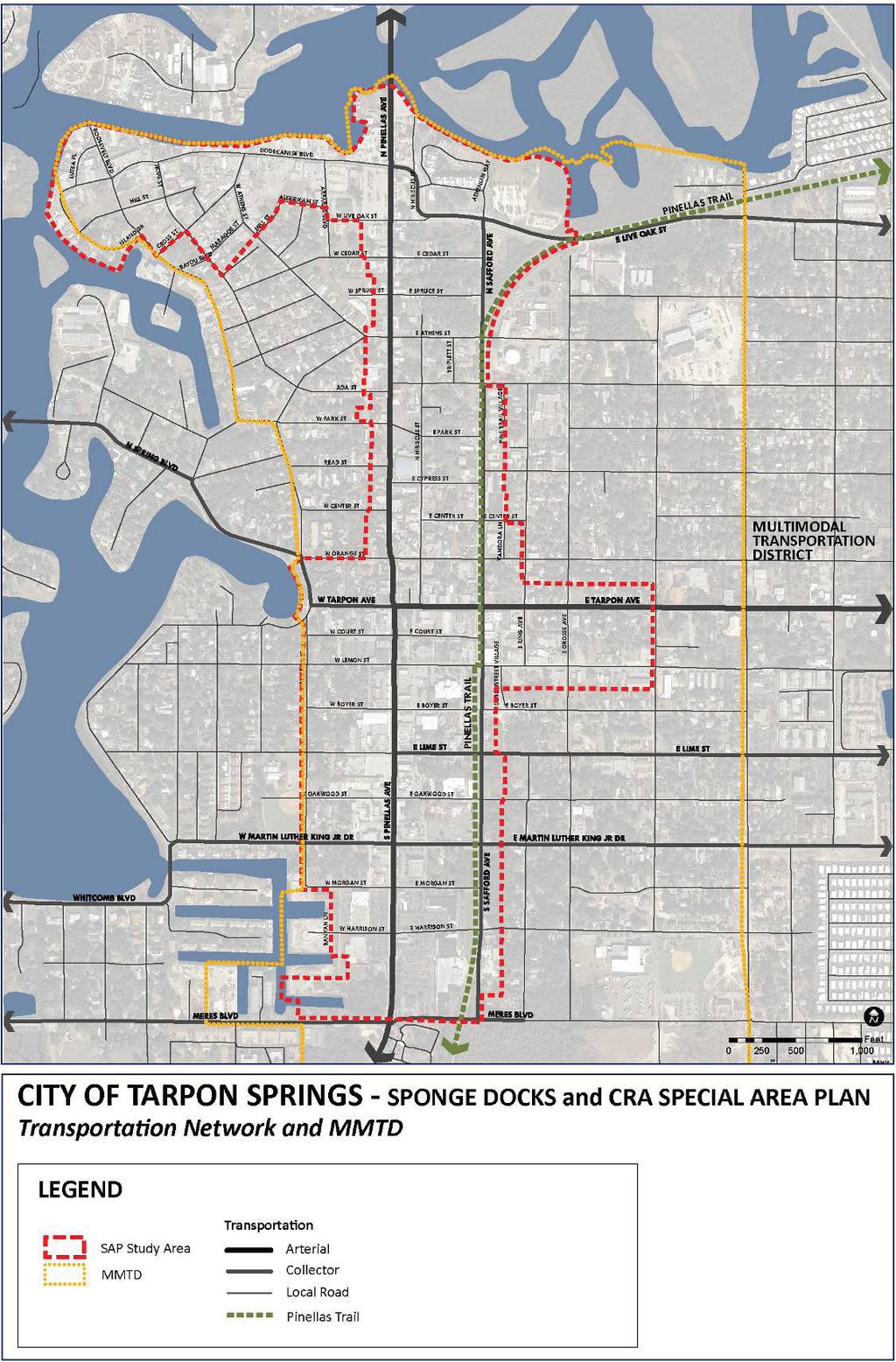
12 Transportation & MMTD 12
TREASURE COAST REGIONAL PLANNING COUNCIL M E M O R A N D U M. To: Council Members AGENDA ITEM 5H
 TREASURE COAST REGIONAL PLANNING COUNCIL M E M O R A N D U M To: Council Members AGENDA ITEM 5H From: Date: Subject: Staff October 17, 2008 Council Meeting Local Government Comprehensive Plan Review Draft
TRANSPORTATION ELEMENT GOALS, OBJECTIVES, AND POLICIES
 TRANSPORTATION ELEMENT GOALS, OBJECTIVES, AND POLICIES GOAL 2 The City shall provide a safe, convenient, effective, and energy efficient multimodal transportation system which is coordinated with the Future
Mobility Districts and Traffic Studies
 Mobility Districts and Traffic Studies During the last Comprehensive Plan update in 2008, the City of Sarasota identified the need to develop a citywide strategy for enhancing the mobility options of all
2040 LUP is a part of the Comprehensive Plan and carries the same legal authority. Economic Challenges
 1.1. Guiding Anchorage s Growth Where will new residents settle over the next two decades? Where will people work, shop, and play? Will there be enough room to grow? How will Anchorage look? Will growth
CHARLES PUTMAN CHARLES PUTMAN AND ASSOCIATES, INC
 MEMORANDUM CHARLES PUTMAN & ASSOCIATES, INC. LAND DEVELOPMENT CONSULTANTS PLANNING ZONING PERMITTING 4722 NW Boca Raton Boulevard, Suite C-106 Boca Raton, Florida 33431 Phone: 561/994-6411 FAX: 561/994-0447
Goals, Objectives and Policies
 Goals, Objectives and Policies GOAL ONE: THE PATTERN OF LAND USE IN PINELLAS COUNTY SHALL PROVIDE A VARIETY OF URBAN ENVIRONMENTS TO MEET THE NEEDS OF A DIVERSE POPULATION AND THE LOCAL ECONOMY, CONSERVE
MEMORANDUM AGENDA ITEM #6c
 South Florida Regional Planning Council MEMORANDUM AGENDA ITEM #6c DATE: FEBRUARY 1, 2010 TO: FROM: SUBJECT: COUNCIL MEMBERS STAFF CITY OF PARKLAND PROPOSED COMPREHENSIVE PLAN AMENDMENT (ALTERNATIVE REVIEW)
Town Center (part of the Comprehensive Plan)
") Town Center (part of the Comprehensive Plan) Mercer Island Town Center Looking North (2014) In 1994, a year-long process culminated in a set of design guidelines and code requirements for the Town Center
Town Center (part of the Comprehensive Plan) Mercer Island Town Center Looking North (2014) In 1994, a year-long process culminated in a set of design guidelines and code requirements for the Town Center
DOMINION BOULEVARD CORRIDOR STUDY AND ECONOMIC DEVELOPMENT STRATEGIC PLAN A MODEL FOR CHESAPEAKE S FUTURE
 DOMINION BOULEVARD CORRIDOR STUDY AND ECONOMIC DEVELOPMENT STRATEGIC PLAN A MODEL FOR CHESAPEAKE S FUTURE Overview I. Draft Plan Process II. Draft Plan Overview a. Market Analysis b. Master Land Use Plan
Future Land Use and Transportation
 Planning & Zoning Board Workshop Comprehensive Plan for Village of Estero Future Land Use and Transportation April 6, 2017 January Kick-off Meeting Public Input What do you like about Estero? Location
CHAPTER 7: Transportation, Mobility and Circulation
 AGLE AREA COMMUNITY Plan CHAPTER 7 CHAPTER 7: Transportation, Mobility and Circulation Transportation, Mobility and Circulation The purpose of the Transportation, Mobility and Circulation Chapter is to
FUTURE LAND USE ELEMENT
 FUTURE LAND USE ELEMENT GOAL I: To create and sustain a great place to live, play, and prosper Objective 1: The City of Ocala shall incorporate the principles and strategies of the Ocala 2035 Vision into
Broadway District Specific Plan. Community Workshop #2 February 23,2016
 Broadway District Specific Plan Community Workshop #2 February 23,2016 1 Agenda Introductions Project Progress Status Upcoming Milestones Emerging Framework Land Use Urban Design Circulation Infrastructure
LAND USE ELEMENT. Purpose. General Goals & Policies
 LAND USE ELEMENT Purpose This Land Use Element contains the goals and policies necessary to support the City s responsibility for managing land resources and guiding development through implementing regulations,
What Pioneer Grove Will Look Like?
 The City of Deerfield Beach has embarked on a journey to create a new town center within the old heart of Deerfield Beach. The new town center is known as Pioneer Grove. Pioneer Grove will be Everybody
, C-MS I June 3, 2016 $1500 pd chk #216918
 , C-MS-8 LOTS 21 THROUGH 40, INCLUSIVE, BLOCK 299 CLEMENTS ADDITION TO THE CITY OF DENVER SOUTHEAST QUARTER OF SECTION 34, TOWNSHIP 3 SOUTH, RANGE 68 WEST, SIXTH PRINCIPAL MERIDIAN, CITY
3.0 PROJECT DESCRIPTION
 3.0 PROJECT DESCRIPTION 3.1 BACKGROUND Under California law (Government Code Section 65300 et seq.), every city and county is required to have a general plan. The general plan is to be comprehensive and
Planning Commission April 4, 2013 BOCC Workshop Page 1
 Planning Commission April 4, 2013 BOCC Workshop Page 1 Planning Commission April 4, 2013 BOCC Workshop Page 2 Planning Commission April 4, 2013 BOCC Workshop Page 3 Planning Commission April 4, 2013 BOCC
CHAPTER 1. Ms. Guajardo s Class - Central Elementary CH 1 1
 INTRODUCTION CHAPTER 1 Ms. Guajardo s Class - Central Elementary CH 1 1 1.1 SETTING South Centre City is a linear corridor south of Downtown Escondido paralleling Centre City Parkway and South Escondido
A. WHAT IS A GENERAL PLAN?
 I. Introduction A. WHAT IS A GENERAL PLAN? A general plan is the planning guideline for the future of a city. It contains goals and policies which regulate urban development, the protection of the natural
TRANSIT ORIENTED DEVELOPMENT PINELLAS COUNTY MPO LIVABLE COMMUNITIES INITIATIVE PINELLAS COUNTY COMPREHENSIVE PLAN AMENDMENTS
 PINELLAS COUNTY MPO LIVABLE COMMUNITIES INITIATIVE MODEL LAND DEVELOPMENT CODE TRANSIT ORIENTED DEVELOPMENT PINELLAS COUNTY COMPREHENSIVE PLAN AMENDMENTS MPO Livable Communities Initiative Goal: Improve
DRAFT Land Use Chapter
 Stevens Creek Urban Village DRAFT 1 18 17 Land Use Chapter INTRODUCTION This Land Use Chapter describes how the Stevens Creek Urban Village will accommodate the growth that is planned for it in the Envision
VILLAGE OF CLEMMONS PLANNING BOARD DRAFT STAFF REPORT
 VILLAGE OF CLEMMONS PLANNING BOARD DRAFT STAFF REPORT PETITION INFORMATION Docket # C-226 Staff Megan Ledbetter Petitioner(s) JBJH Properties, LLC Owner(s) JBJH Properties, LLC Subject Property 5892-49-1766
City of Long Beach. creating vibrant and exciting places
 City of Long Beach creating vibrant and exciting places Land Use Element Urban Design Element Overview of the two draft General Plan elements Discuss areas of change Economic goals of the plans Case study
2136 & 2148 Trafalgar Road Town of Oakville Region of Halton
 PLANNING JUSTIFICATION REPORT 2136 & 2148 Trafalgar Road Town of Oakville Region of Halton Zoning By-Law Amendment Application 2500674 Ontario Inc. November 2016 Table of Contents Page 1.0 Location/Summary
Urban Development Areas Frederick County
 18 Urban Development Areas Frederick County UDA Needs Profile: All UDAs Frederick County, Virginia's northernmost county has two UDA s, surrounded by the City of Winchester and located adjacent to the
City of Fort Lauderdale UPTOWN URBAN VILLAGE. Public Workshop December 7, 2016
 Public Workshop December 7, 2016 Workshop Agenda Introductions Project Presentation o o o History Project Scope/Timeline Character of Study Area o o o o Land Use Public Realm/Pedestrian Mobility Multimodal
Planning Commission March 14, Presented by: City of Bellingham Port of Bellingham
 Planning Commission March 14, 2013 Presented by: City of Bellingham Port of Bellingham 1 Agenda Waterfront District Background Waterfront District Proposal Overview Sub-area Plan Development Regulations
ARLINGTON COUNTY, VIRGINIA
 ARLINGTON COUNTY, VIRGINIA County Board Agenda Item Meeting October 15, 2005 DATE: September 28, 2005 SUBJECT: Request to Advertise the adoption of the 2005 Clarendon Sector Plan C. M. RECOMMENDATION:
AWH REPORT OF THE PLANNING AND DEVELOPMENT DEPARTMENT FOR APPLICATION FOR REZONING ORDINANCE TO PLANNED UNIT DEVELOPMENT
 AWH REPORT OF THE PLANNING AND DEVELOPMENT DEPARTMENT FOR APPLICATION FOR REZONING ORDINANCE TO PLANNED UNIT DEVELOPMENT MAY 8, 2014 The Planning and Development Department hereby forwards to the Planning
SECTION ONE: INTRODUCTION. introduction
 introduction 1 INTRODUCTION Since it was first established in 1843 as a trading post for the Hudson s Bay Company, Victoria has evolved into a Provincial capital city that is recognized across Canada and
Bourne Downtown Site Planning
 Prepared for: The Town of Bourne, MA In Cooperation with: Bourne Financial Development Corporation Prepared by:, Inc. June 24, 2009 Table of Contents Introduction and Summary... 1 Site Existing Conditions...
SECTION UNIFIED DEVELOPMENT ORDINANCE SECTION Part 1 Ordinance. ARTICLE 1 Zoning Districts
 SECTION 1-100 UNIFIED DEVELOPMENT ORDINANCE SECTION 1-300 Part 1 Ordinance SECTION 1-100. Introduction. ARTICLE 1 Zoning Districts Crystal Lake strives to maintain a balance of various land uses for a
Introduction. Chapter 1. Purpose of the Comprehensive Plan Plan Organization Planning Process & Community Input 1-1
 Chapter 1 Introduction Lakewood 2025: Moving Forward Together Purpose of the Comprehensive Plan Plan Organization Planning Process & Community Input 1-1 Purpose of the Comprehensive Plan The Comprehensive
SAN RAFAEL GENERAL PLAN 2040 INTRODUCTION AND OVERVIEW
 SAN RAFAEL GENERAL PLAN 2040 INTRODUCTION AND OVERVIEW Steering Committee Presentation February 14, 2018 Purpose of General Plan Guide land use and development decisions Coordinate transportation, infrastructure,
The Five Components of the McLoughlin Area Plan
 The Five Components of the McLoughlin Area Plan This documents contains the complete language of the five components of the McLoughlin Area Plan: The Vision Statement The Values The Guiding Principles
Corridor Vision. 1Pursue Minnehaha-Hiawatha Community Works Project. Mission of Hennepin County Community Works Program
 1Pursue Minnehaha-Hiawatha Community Works Project Minnehaha-Hiawatha Community Works is a project within the Hennepin Community Works (HCW) program. The mission of the HCW program is to enhance how the
PLAN ELEMENTS WORKSHOP. April 5, 2016
 PLAN ELEMENTS WORKSHOP April 5, 2016 needs more housing. But there is no one-size fits-all solution. Every neighborhood has its own character. In some places, density is not only appropriate it is badly
ORDINANCE NO
 ORDINANCE NO. 8923-16 AN ORDINANCE OF THE CITY OF CLEARWATER, FLORIDA, MAKING AMENDMENTS TO THE COMPREHENSIVE PLAN OF THE CITY BY UPDATING INTRODUCTION AND THE FUTURE LAND USE NEEDS SUMMARY SECTIONS OF
CITY OF PUYALLUP. Background. Development Services
 CITY OF PUYALLUP Development Services 333 South Meridian Puyallup WA 98371 To: City Council From: Katie Baker, AICP, Planning Division Re: South Hill Neighborhood Plan Adoption Date: (Meeting date: February
17.11 Establishment of Land Use Districts
 17.11 Establishment of Land Use Districts 17.11.010 Purpose. To promote the health, safety, and general welfare of City residents and those who come to South Salt Lake to work, exchange commerce and recreate.
THAT the attached Terms of Reference for the Thornhill Centre Street Study be approved.
 COMMITTEE OF THE WHOLE AUGUST 18, 2003 THORNHILL CENTRE STREET STUDY PLANNING FILE: 15.92 Recommendation The Commissioner of Planning recommends: THAT the attached Terms of Reference for the Thornhill
West Ocala Vision & Community Plan City Council Work Session. Presented by West Ocala Community Plan Steering Committee
 West Ocala Vision & Community Plan City Council Work Session Presented by West Ocala Community Plan Steering Committee November 29,2011 Ocala 2035 Vision West Ocala Community Vision & Master Plan West
EXHIBIT A. Tax Increment Reinvestment Zone No. 1 (Town Center) First Amended Project Plan 1
 First Amended Project Plan 1") EXHIBIT A Tax Increment Reinvestment Zone No. 1 (Town Center) First Amended Project Plan 1 1 As amended by Resolution No. 2008-02-001(TR1R) of the Tax Increment Reinvestment Zone No.1, and approved to
EXHIBIT A Tax Increment Reinvestment Zone No. 1 (Town Center) First Amended Project Plan 1 1 As amended by Resolution No. 2008-02-001(TR1R) of the Tax Increment Reinvestment Zone No.1, and approved to
DALY CITY VISIONING PROCESS COMMUNITY WORKSHOP 3 MAY 8, 2008
 DALY CITY VISIONING PROCESS COMMUNITY WORKSHOP 3 MAY 8, 2008 PROCESS General Plan - a statement of the community s values, vision and aspirations for now and into the future... Timeframe LONG TERM - 2030
1. FUTURE LAND USE ELEMENT Goals, Objectives, and Policies
 1. Goals, Objectives, and Policies The has limited vacant land remaining for new development. Redevelopment is anticipated to represent nearly all development activity within the City. More City residents
Urban Development Areas Bedford County
 5 Urban Development Areas Bedford County UDA Needs Profile: All UDAs Bedford County has designated two UDAs: areas just outside the Bedford City Limits (generally to the south and east of the city) and
Somers Point Master Plan
 Somers Point Master Plan Progress Report and Public Meeting August 20, 2014 Master Plan Reexamination Municipal Land Use Law require that all municipalities reexamine their master plan every ten years.
City of Tacoma Planning and Development Services
 Agenda Item D-3 City of Tacoma Planning and Development Services To: Planning Commission From: Stephen Atkinson, Associate Planner, Planning Services Division Subject: Land Use Designations - Phase 2 Meeting
DRAFT Subject to Modifications
 TREASURE COAST REGIONAL PLANNING COUNCIL M E M O R A N D U M DRAFT Subject to Modifications To: Council Members AGENDA ITEM 5F From: Date: Subject: Staff September 17, 2010 Council Meeting Local Government
S A C R A M E N T O C O U N T Y JACKSON HIGHWAY & GRANT LINE EAST VISIONING STUDY
 JACKSON HIGHWAY & GRANT LINE EAST S A C R A M E N T O C O U N T Y P L A N N I N G D E P A R T M E N T SUMMARY AND WORKBOOK November 19, 2008 History of the Visioning Study Sacramento County has two growth
MEMORANDUM AGENDA ITEM #IV.C
 MEMORANDUM AGENDA ITEM #IV.C DATE: NOVEMBER 27, 2017 TO: FROM: COUNCIL MEMBERS STAFF SUBJECT: LOCAL GOVERNMENT COMPREHENSIVE PLAN PROPOSED AND ADOPTED AMENDMENT CONSENT AGENDA Pursuant to Section 163.3184,
DRAFT City of Titusville 2040 Comprehensive Plan Future Land Use, Housing, and Transportation Elements April 16, 2018
 DRAFT City of Titusville 2040 Comprehensive Plan Future Land Use, Housing, and Transportation Elements April 16, 2018 Prepared by Canin Associates for the City of Titusville About the Comprehensive Plan:
Transit / Housing Oriented Redevelopment
 Broward County Urban Planning and Redevelopment Department Kick-Off Meeting October 24, 2007 Transit / Housing Oriented Redevelopment 1 Future Land Use 2 Broward County Charter Voters approved in 1974.
PSRC REVIEW REPORT & CERTIFICATION RECOMMENDATION
 PSRC REVIEW REPORT & CERTIFICATION RECOMMENDATION KITSAP COUNTY COUNTYWIDE PLANNING POLICIES July 2, 2012 BACKGROUND A major emphasis of the Washington State Growth Management Act (GMA) is the need to
Prosperity Hucks Area Plan. Transportation and Planning Committee May 11, 2015
 Prosperity Hucks Area Plan Transportation and Planning Committee May 11, 2015 Presentation Outline 1. Background and Location 2. Community Dialog Process 3. Activity Center Recommendations 4. Wedge Recommendations
VICTORIA DOWNTOWN DEVELOPMENT PLANNING
 VICTORIA DOWNTOWN DEVELOPMENT PLANNING A Vision & Guide for the Future Downtown Victoria thrives as a center for the community, offering a great mix of entertainment, culture, business, and recreational
future land use element
 1 The purpose of this element is to establish future land use patterns consistent with the goals, objectives, and policies of this Plan. Future land use patterns are depicted on the Future Land Use Map
Northwest Rail Corridor and US 36 BRT Development Oriented Transit Analysis 4.4 STATION AREA FINDINGS
 4.4 STATION AREA FINDINGS Each station is different, and each one requires a separate set of recommendations based on the vision for the site. This section outlines an initial TOD strategy and recommendations
4.1.3 LAND USE CATEGORIES
 4.1.3 LAND USE CATEGORIES a. City Center District The City Center District incorporates the existing character and mix of uses in downtown Belmont to encourage redevelopment and new development in keeping
Chapter Three, Future Land Use Element City of St. Petersburg Comprehensive Plan
 FUTURE LAND USE ELEMENT Chapter Three, Future Land Use Element Sections: 3.1 Introduction 3.2 Goals, Objectives and Policies ISSUE: Implementation of the Vision 2020 Plan ISSUE: Conceptual Land Use Pattern
LAND USE OVERVIEW WHAT YOU WILL FIND IN THIS CHAPTER
 LAND USE WHAT YOU WILL FIND IN THIS CHAPTER Information about the City s expected population and employment growth. Description and capacity of existing and future land use designations. Policies that
Sheridan Boulevard S TAT I O N A R E A P L A N S H E R I D A N B O U L E VA R D S TAT I O N A R E A P L A N
 Sheridan Boulevard S TAT I O N A R E A P L A N 1 City of Lakewood Adopted November, 2006 S H E R I D A N B O U L E VA R D S TAT I O N A R E A P L A N The Vision The City of Lakewood s overall vision is
TREASURE COAST REGIONAL PLANNING COUNCIL M E M O R A N D U M. To: Council Members AGENDA ITEM 5I
 TREASURE COAST REGIONAL PLANNING COUNCIL M E M O R A N D U M To: Council Members AGENDA ITEM 5I From: Date: Subject: Staff December 12, 2008 Council Meeting Local Government Comprehensive Plan Review Town
Table of Contents. Elm Avenue Improvement Plan City of Waco, Texas. Introduction 1. Existing Context 1 Figure 1 2.
 Table of Contents Introduction 1 Existing Context 1 Figure 1 2 Plan Guidelines 3 Future Urban Form 4 The West-End 4 Main Street 6 The East-End 7 Figure 2 9 Public Improvement Recommendations 7 General
open public hearing and allow public comment request to continue LPA public hearing to January 16, 2014 at 10:30 am
 TODAY S AGENDA Work Session LPA Transmittal Public Hearing open public hearing and allow public comment request to continue LPA public hearing to January 16, 2014 at 10:30 am staff will issue a recommendation
REPORT OF THE PLANNING AND DEVELOPMENT DEPARTMENT FOR APPLICATION FOR REZONING ORDINANCE TO PLANNED UNIT DEVELOPMENT AUGUST 18, 2016
 REPORT OF THE PLANNING AND DEVELOPMENT DEPARTMENT FOR APPLICATION FOR REZONING ORDINANCE TO PLANNED UNIT DEVELOPMENT AUGUST 18, 2016 AWH The Planning and Development Department hereby forwards to the Planning
McCowan Precinct Plan Study Background & Deliverables
 1 DRAFT & WITHOUT PREJUDICE McCowan Precinct Plan Study Background & Deliverables In September, 2011, City Planning (Scarborough District) began a study of an area within the Scarborough Centre, identified
This Review Is Divided Into Two Phases:
 Semiahmoo Town Centre Review The purpose of this review: To review the Semiahmoo Town Centre Concept Plan, originally approved in 1993, to ensure that this centre will continue to serve the needs of South
Staff Report and Recommendation
 Community Planning and Development Planning Services 201 W. Colfax Ave., Dept. 205 Denver, CO 80202 p: 720.865.2915 f: 720.865.3052 www.denvergov.org/cpd TO: City Council Neighborhoods and Planning Committee
City Center Neighborhood Plan
 [1] City Center Neighborhood Plan As adopted by Ordinance No. 2014-09-049 and amended by Ordinance Nos. Formerly CBD Neighborhood as adopted by Ordinance No. 8868 and amended by Ordinance Nos. 8946, 9693,
Welcome to the Oakridge Centre Open House
 Welcome to the Oakridge Centre Open House Why is the City hosting this event? This open house is to inform you of a rezoning application submitted to the City of Vancouver to amend the existing CD-1 (Comprehensive
YONGE STEELES CORRIDOR SECONDARY PLAN. Young + Wright / IBI Group Architects Dillon Consulting Ltd. GHK International (Canada) Ltd.
 Ltd.") PART A: PREAMBLE 1.0 PURPOSE The purpose of this Secondary Plan is to provide a development framework for intensification of the Yonge/ Steeles corridor including the north side of Steeles Avenue West
PART A: PREAMBLE 1.0 PURPOSE The purpose of this Secondary Plan is to provide a development framework for intensification of the Yonge/ Steeles corridor including the north side of Steeles Avenue West
DRAFT ROOSEVELT ROAD. District Recommendations. Figure 5.23 The Roosevelt Road Corridor
 CHAPTER 5 Figure 5.23 The Road Corridor Road will develop as a mixed-use corridor, emphasizing regional retail, west of the river and mixed-use development east of the river. KEY RECOMMENDATIONS 1. High
III. Design Principles
 III. Design Principles The design of Bay Meadows Phase II has been guided by a series of Urban Design Principles. These principles, informed by consultant site analysis, City staff recommendations, and
Urban Planning and Land Use
 Urban Planning and Land Use 701 North 7 th Street, Room 423 Phone: (913) 573-5750 Kansas City, Kansas 66101 Fax: (913) 573-5796 Email: planninginfo@wycokck.org www.wycokck.org/planning To: From: City Planning
6 PORT SYDNEY SETTLEMENT AREA
 Section 6 Port Sydney Page 61 6 PORT SYDNEY SETTLEMENT AREA 6.1 Basis and Principles Village of Port Sydney Waterfront Community Existing Services 6.1.1 Port Sydney is an historic settlement that has developed
SOUTH NATOMAS COMMUNITY PLAN
 SOUTH NATOMAS Community Plan Part Three : COMMUNITY PLAN AREAS AND SPECIAL STUDY AREAS SACRAMENTO 2030 GENERAL PLAN Contents Community Location... 3-SN-3 Community Vision... 3-SN-4 Community Profile...
Route 1 Corridor Study
 Route 1 Corridor Study Westbrook, Connecticut A Vision for the Connecticut Shoreline Public Informational Meeting July 28, 2015 Lower Connecticut River Valley Council of Governments Fitzgerald & Halliday,
Corridors. Re-vitalize our Corridors and Gateways
 Corridors Re-vitalize our Corridors and Gateways Artist s rendering from the 287 Strategic Plan, 2015 Corridors are the major throughways of Loveland but they also provide important commercial, community
Blueprint Denver A BLUEPRINT FOR AN INCLUSIVE CITY. Executive Summary
 Blueprint Denver A BLUEPRINT FOR AN INCLUSIVE CITY Executive Summary PUBLIC REVIEW DRAFT 2 1/7/2019 DENVERIGHT BLUEPRINTDENVER Blueprint Denver: A Blueprint for an Inclusive City An Equitable City Planning
Policies and Code Intent Sections Related to Town Center
 Policies and Code Intent Sections Related to Town Center The Town Center Vision is scattered throughout the Comprehensive Plan, development code and the 1994 Town Center Plan. What follows are sections
Anatomy of A Vibrant Downtown. Anatomy of a Vibrant Downtown
 Anatomy of A Vibrant Downtown The goal of MAIN ST. REVITALIZATION PLANNING is to provide a framework that will help transform your downtown into a VIBRANT DOWNTOWN a place where people love to LIVE, WORK,
ORDINANCE NO WHEREAS, the recommendations from the Pinellas County Local Planning Agency have been received and considered.
 ORDINANCE NO. 16-55 AN ORDINANCE OF THE COUNTY OF PINELLAS, AMENDING THE FUTURE LAND USE AND QUALITY COMMUNITIES ELEMENT OF THE PINELLAS COUNTY COMPREHENSIVE PLAN TO ADOPT THE CRYSTAL BEACH COMMUNITY OVERLAY;
Welcome. Walk Around. Talk to Us. Write Down Your Comments
 Welcome This is an information meeting introducing the applications for proposed redevelopment of the Yorkdale Shopping Centre site at 3401 Dufferin Street and 1 Yorkdale Road over the next 20+ years,
Plano Tomorrow Vision and Policies
 Plano Tomorrow Vision and Policies PLANO TOMORROW PILLARS The Built Environment The Social Environment The Natural Environment The Economic Environment Land Use and Urban Design Transportation Housing
Planning & Zoning Commission Staff Report
 Planning & Zoning Commission Staff Report Meeting Date: May 26, 2015 Drafted by: Katherine Harrison-Rogers CASE # Z2886 PROJECT NAME: APPLICANT/ REPRESENTATIVE: Shawna Runyan PROPERTY OWNER: 1840 (previously
LAND USE AMENDMENT DOWNTOWN COMMERCIAL CORE (WARD 7) MACLEOD TRAIL SE AND 5 AVENUE SE BYLAW 254D2017
 MACLEOD TRAIL SE AND 5 AVENUE SE BYLAW 254D2017") Page 1 of 10 EXECUTIVE SUMMARY This Land Use Amendment application seeks to redesignate a full downtown block (currently the YWCA site) from a Direct Control based on the CM-2 District (Land Use Bylaw
Page 1 of 10 EXECUTIVE SUMMARY This Land Use Amendment application seeks to redesignate a full downtown block (currently the YWCA site) from a Direct Control based on the CM-2 District (Land Use Bylaw
WELCOME and introduction
 1 WELCOME and introduction Mobility Hub Locations within Burlington STUDY OVERVIEW STUDY OBJECTIVES The City of Burlington is developing four Area Specific Plans, one for each of Burlington s Mobility
CITY OF BELLINGHAM PLANNING DEPARTMENT STAFF REPORT
 1 1 1 1 1 1 1 1 0 1 0 1 0 1 0 CITY OF BELLINGHAM PLANNING DEPARTMENT STAFF REPORT Agenda Topic: For: Staff Contact: I. Project Summary Review of the Waterfront District subarea plan and associated documents,
TABLE OF CONTENTS APPENDIX A PUBLIC WORKSHOP INFORMATION APPENDIX B BUSINESS CENTER TECHNICAL REPORTS APPENDIX C CORRESPONDENCE IN SUPPORT/OPPOSITION
 TABLE OF CONTENTS RCTOD REZONE AMENDMENT DESCRIPTION... 1 MAP SERIES... 2 RESIDENTIAL COMMERCIAL TRANSITION OVERLAY DISTRICT... 7 FINDINGS OF FACT.15 CONCURRENCY SUMMARY REPORT... 16 APPENDIX A PUBLIC
Land Use. Hardware Street Vendor Mixed-Use
 Land Use Definition Land Use is the way a piece of real estate is utilized. Existing, proposed, and adopted land uses all play a role in the planning process. Once a land use plan is adopted, the next
Status Report: MD 355 Project
 Status Report: MD 355 Project OCTOBER 2006 M-NCPPC MONTGOMERY COUNTY PLANNING DEPARTMENT Summary of Community Comments, and break to the Results of the MD 355 Participation Session Brookside Gardens -
DENVER DESIGN DISTRICT GDP
 DENVER DESIGN DISTRICT GDP Urban Design Standards and Guidelines November 17, 2008 Amended February 3, 2016 City and County of Denver CF Property Management, Inc. C/O Denver Design District - Starboard
Former Rockcliffe Airbase Community Design Plan Guiding Design Vision and Principles December 4, 2013
 APPENDIX 5 - Guiding Design Vision and Principles Former Rockcliffe Airbase Community Design Plan Guiding Design Vision and Principles December 4, 2013 Vision Statement The redevelopment of the former
REZONING GUIDE. Zone Map Amendment (Rezoning) - Application. Rezoning Application Page 1 of 3. Return completed form to
 - Application. Rezoning Application Page 1 of 3. Return completed form to") Zone Map Amendment (Rezoning) - Application COMMUNITY PLANNING & DEVELOPMENT REZONING GUIDE Rezoning Application Page 1 of 3 PROPERTY OWNER INFORMATION* CHECK IF POINT OF CONTACT FOR APPLICATION Property
Zone Map Amendment (Rezoning) - Application COMMUNITY PLANNING & DEVELOPMENT REZONING GUIDE Rezoning Application Page 1 of 3 PROPERTY OWNER INFORMATION* CHECK IF POINT OF CONTACT FOR APPLICATION Property
Land Use Amendment in Southwood (Ward 11) at and Elbow Drive SW, LOC
 at and Elbow Drive SW, LOC") 2018 November 15 Page 1 of 10 EXECUTIVE SUMMARY This land use amendment application was submitted by Rick Balbi Architect on 2017 August 31 on behalf of Sable Developments Ltd, and with authorization from
2018 November 15 Page 1 of 10 EXECUTIVE SUMMARY This land use amendment application was submitted by Rick Balbi Architect on 2017 August 31 on behalf of Sable Developments Ltd, and with authorization from
Sustainable Growth. Sustainable Growth
 2 Sustainable Growth Sustainable Growth SUSTAINABLE GROWTH 2.1 COMMUNITY VISION... 2-5 2.2 THE CITY SYSTEM... 2-7 2.2.1 AREAS... 2-7 2.2.2 CITY-WIDE SYSTEMS... 2-8 2.2.3 PROVINCIAL PLAN BOUNDARIES AND
Tyvola & Archdale Transit Station Area Plan. June 5, 2008
 Tyvola & Archdale Transit Station Area Plan Second Public Meeting June 5, 2008 Presentation Outline 1. Purpose and Process 2. Station Area Overview 3. Plan Recommendations 4. Comments Received and Proposed
Guiding Principles, Objectives, Strategies and Policies
 Guiding Principles, Objectives, Strategies and Policies Section 1 Introduction These Guiding Principles were adopted as part of the 1999 Athens-Clarke County Comprehensive Plan and are carried over, in